HAL Id: hal-01824190
https://hal.univ-lorraine.fr/hal-01824190
Submitted on 26 Jun 2018
HAL is a multi-disciplinary open access
archive for the deposit and dissemination of
sci-entific research documents, whether they are
pub-lished or not. The documents may come from
teaching and research institutions in France or
abroad, or from public or private research centers.
L’archive ouverte pluridisciplinaire HAL, est
destinée au dépôt et à la diffusion de documents
scientifiques de niveau recherche, publiés ou non,
émanant des établissements d’enseignement et de
recherche français ou étrangers, des laboratoires
publics ou privés.
subsurface: a review
Guillaume Caumon
To cite this version:
Guillaume Caumon. Geological objects and physical parameter fields in the subsurface: a review.
B.S. Daya Sagar, Qiuming Cheng, Frits Agterberg. Handbook of Mathematical Geosciences, Springer,
pp.567-588, In press, 978-3-319-78998-9. �10.1007/978-3-319-78999-6_28�. �hal-01824190�
es: Fifty Years of IAMG. https://doi.org/10.1007/978-3-319-78999-6_28
28 Geological objects and physical parameter
fields in the subsurface: a review.
Guillaume Caumon,
GeoRessources-ENSG, Université de Lorraine – CNRS –CREGU. 2 rue du Doyen
Marcel Roubault, F-54500 Vandoeuvre-lès-Nancy, France.
Abstract: Geologists and geophysicists often approach the study of the Earth using different and complementary perspectives. To simplify, geologists like to define and study objects and make hypotheses about their origin, whereas geo-physicists often see the earth as a large, mostly unknown multivariate parameter field controlling complex physical processes. This chapter discusses some strate-gies to combine both approaches. In particular, I review some practical and theo-retical frameworks associating petrophysical heterogeneities to the geometry and the history of geological objects. These frameworks open interesting perspectives to define prior parameter space in geophysical inverse problems, which can be consequential in under-constrained cases.
28.1 Introduction
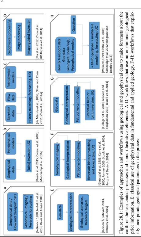
The earth is three-dimensional, heterogeneous and, for its major part, inacces-sible to direct observations. A consequence is that the static and dynamic parame-ters governing physical processes below the earth surface are generally poorly known. A recurrent challenge for geoscientists and engineers is, therefore, to pre-dict the likely nature or behavior of the subsurface from limited data. In all fields of geophysics sensu lato, these forecasts may use physically and mathematically-based data processing such as upward continuation of potential fields, seismic processing, classical processing of ground penetrating radar (Nobakht et al. 2013), reservoir production decline curves (Davis and Annan 1989; Fetkovich 1980, Fig. 28.1A) or the resolution of an inverse problem that explicitly uses physical models computing observations from some earth parameters and physical parameters (Fig. 28.1B-D,F-H). In geology, forecasts (e.g., about the location and volume of a spe-cific formation or resource) and geological scenarios involve direct observations and geophysical images (Jackson and Rotevatn (2013); Perrouty et al. (2014); Fig. 28.1E). In this process, the loop may not always close: in the end, the interpreta-tions are not guaranteed to be compatible with the initial geophysical observainterpreta-tions. This may or may not be a problem, depending on the purpose of this interpreta-tion. For example, a qualitative match between reflection
Fig ur e 28 .1 : E xam ples of a pp ro ac hes an d wo rk flo ws us in g geo lo gical an d ge op hy sical data to m ak e fo rec asts a bo ut th e ea rth o r th e ass ociate d pr oce ss es an d so m e illu str ativ e re fe ren ce s. A -D: wo rk flo ws th at us e no o r m in im al ge olo gical pr io r in fo rm atio n. E : class ical u se of g eo ph ys ical data in f un dam en tal an d ap plied g eo lo gy . F -H: wo rk flo ws th at ex pli c-itly in co rp or ate geo lo gical par am eter s in th e pr oce ss .
seismic data and structural interpretations is probably sufficient to discuss fault growth models (Jackson and Rotevatn 2013), whereas such mismatch can be prob-lematic in other tasks such as natural resource assessment (Caumon 2010; Jessell et al. 2014). Another practical problem is the interpretation and fusion of several independent data sets corresponding to different physical or geological observa-tions (Corbel and Wellmann 2015; Paasche 2016). Geostatistics (Chiles and Delfiner 2012; Goovaerts 1997) was historically developed with these problems in mind, and is an attractive theoretical framework to recombine point and volume data coming from geophysical images consistently with spatial statistics. However geological reasoning and statistical reasoning are of different nature (Frodeman 1995), so honoring some spatial statistics is very useful but not always sufficient to represent geological concepts. Therefore, several methodologies have been in-troduced to explicitly incorporate geological knowledge in subsurface interpreta-tion, all of them explicitly considering geological objects (Fig. 28.1F-H).
The main focus of this chapter is to review the main frameworks by which geo-logical concepts can be represented in earth models and inverse methods address-ing several types of physics. Thus, it aims at complementaddress-ing the existaddress-ing reviews and discussions of Linde et al. (2015) and Jessell et al. (2014), who address this problem with similar objectives but different perspectives. As the topic is very vast, the reader is also referred to previous review papers related to this topic (Farmer 2005; Lelièvre and Farquharson 2016; Linde et al. 2015; de Marsily et al. 2005; Mosegaard and Hansen 2016; Oliver and Chen 2011; Pyrcz et al. 2015; Zhou et al. 2014a). Several books also present complementary perspectives and more complete descriptions and details (Agterberg 2014; Caers 2011; Mallet 2014; Mallet 2002; Perrin and Rainaud 2013; Pyrcz and Deutsch 2014). Section 28.2 provides further motivations for considering geology in geophysical models, and tries to define what “geology” means in that sense. Then, Section 28.3 briefly describes the type of parameterizations classically used in computational physics. We discuss some links between these physical parameterizations and the frame-works used to represent geological domains in Section 28.4.
28.2 Motivations for explicit geological parameterizations
A wealth of perspectives is essential and complementary to make progresses in the understanding of our planet and its resources. This is exemplified by the vari-ous disciplines involved in natural resource characterization, see for instance Ringrose and Bentley (2015). Feedbacks and interactions between the various ap-proaches generate many types of possible workflows to integrate geological data and produce forecasts, as illustrated in Fig. 28.1. For example, geophysical pro-cessing and inverse methods that use minimal geological prior information (Fig. 28.1A-D) are typically considered as data for geological interpretations (Fig. 28.1E). Whereas these “minimal prior” approaches are not this chapter’s focus,
they are very useful and are always used to some extent in practical studies, be-cause they provide at least a useful first-order view of the geological domain. This is illustrated in particular in deterministic workflows of Fig. 28.1H that strive for fit-for purpose, simplest as possible, subsurface models (Elrafie et al. 2008; Ringrose and Bentley 2015; Williams et al. 2004). They are also conceptually sat-isfying in the sense that they produce images or forecasts that depend on the phys-ics, hence can be claimed to be parsimonious and objective. As a consequence of this parsimony and of the non-linear nature of most involved physical processes, these models make it difficult to evaluate uncertainty (Watson et al. 2013). The term “objective” is also relative, as some choices are always made in these meth-ods. In data processing methods these subjective choices relate to the underlying model assumptions (e.g., sub-horizontal layers). In inverse methods, choices must also be made about the parameterization, and a statistical model (e.g., the multi-Gaussian model) or a particular regularization (e.g., Mosegaard 2011).
Among the approaches that try to get the most out of the physics with minimal assumptions, recent and most promising developments use several types of data and petrophysical models to constrain local anisotropy, see for instance Clapp et al. 2004; Ma et al. 2012; Sava et al. 2014; Zhou et al. 2014b and recent reviews in geophysical imaging (Meju and Gallardo 2016), reservoir seismology (Bosch et al. 2010), hydrogeophysics (Linde and Doetsch 2016), mineral exploration (Lelièvre and Farquharson 2016), petroleum exploration (Moorkamp et al. 2016). Two main ideas underlie these approaches. First, some local structural orientations are in-ferred from borehole data or other geophysical data to constrain the covariance function used during inversion. Second, a petrophysical model that associates the various physical parameters is used to exploit the existing correlation between the physical parameters. As these correlations generally depend on the rock type, the model often includes discrete variables that estimate or sample the rock type at a given location. This notion of rock type is close to the notion of lithofacies, so it is a way to integrate geological reasoning into inverse methods.
In the field of reservoir engineering and hydrogeology, methods incorporating prior geological knowledge in flow and transport models have also been devel-oped very early on, as discussed in several review papers (Farmer 2005; Linde et al. 2015; de Marsily et al. 2005; Oliver and Chen 2011; Zhou et al. 2014a). One fundamental reason is that flow and transport processes can be highly non-linear while pressure and concentration measurements are generally quite sparse as com-pared to the number of potential factors influencing fluid transfers in porous and fractured media. The same observation holds in potential field inversion, where geological prior information can significantly help addressing the ill-posedness of the inverse problem (Lelièvre and Farquharson 2016). But what does “geological prior” exactly mean?
As noted in particular by Frodeman (1995), geology is an interpretive science which includes a significant component of historical thinking. One aim of geology is to describe the earth in historical terms by identifying the main geological pro-cesses and their impact. In terms of scientific philosophy, it is interesting to high-light that geology generally produces refutable scenarios, whereas mathematics are concerned with formal and irrefutable proofs (given some hypotheses). The encounter of these two scientific methods is deeply written in the DNA of Mathe-matical Geosciences. Advanced methods in physically-based modeling have been developed to quantitatively model geological processes. Some very interesting in-verse methods that use such models have been developed recently to quantitative-ly integrate spatial observations (Charvin et al. 2009; Cross and Lessenger 1999; Gallagher et al. 2009). These methods are ideal in the sense that they could in principle unify geology and geophysics rigorously. However, the interplay of mul-tiple coupled physical and chemical processes at geological time scales remains extremely challenging to model on a computer. The use of such models in an in-verse framework is also very challenging, as the number of unknown or poorly known parameters makes the inverse problem highly ill-posed and computational-ly intractable. This empty space problem is very general and applies to most in-verse problems in geosciences, but it is critical when an explicit time dimension is considered because the density of information in time-space is very small (e.g., only a few points typically constrain pressure and temperature in basin studies). This explains why most of the methods in Fig. 28.1-E-H do not explicitly consider geological time and instead use an object-based approach, a statistics-based ap-proach or a combination of both to represent the geological prior information and make forecasts in the 3D physical space.
Classically, the object-based strategy is essential to the geological approach. For example, geological mapping typically decomposes a complex reality into discrete and interconnected tectonic, igneous, metamorphic, diagenetic, strati-graphic and sedimentological objects. These object definitions do integrate histor-ical and process-based considerations. For instance, time is explicitly considered in the definition of the remarkable surfaces that sequence stratigraphers use to in-terpret geoscience data. The characterization of these objects in mathematical and computational terms has been a significant focus of the IAMG for that last 50 years. The statistics-based approach, another clear focus of the IAMG, is clearly complementary to the object-based approach. Indeed, objects are heterogeneous, boundaries between objects may be difficult to define and objects can be difficult to map from available observations. Statistical reasoning is key to address these problems. In this chapter, we will try to explain a few manners by which the ob-ject-based and statistics-based methods interact in the frame of geo-data and phys-ical modeling integration. For this, we will start from the perspective of what physical modeling needs.
28.3 Parameterizations for physical models
Sambridge et al. (2012), among others, give a very crisp and generic summary of the parameterizations used in most numerical physical modelling methods. In this view, a model is defined at any point of the physical space by a set of basis functions:
. (1)
For example, in the finite element method with linear triangular elements, a basis function is defined for each mesh vertex : is equal to 1, is
equal to 0 and linearly decreases in the mesh elements adjacent to . The val-ues are the parameter values (e.g., thermal conductivity) associated to the mesh vertices.
The general formulation (1) allow to compute or approximate differential opera-tors to solve partial differential equations describing physical processes. Many re-cent advances in computational physics consist of particular choices of basis func-tions. For instance, in the extended finite element method, the use of Heaviside basis functions to represent internal discontinuities in a mesh was a step change in the computation of fracture growth (Moës et al. 2002). Another very active re-search field concerns the combination of basis functions at several scales (e.g., Efendiev et al. 2013). These methods have been applied for instance in finite vol-ume modeling of flow in porous media to solve the flow and transport equations at two distinct and interacting scales (Jenny et al. 2003; Møyner and Lie 2014). Equation (1) is also compatible with the theory of spatial random fields. At point scale, the values are seldom known below the Earth surface. Geostatistics of-fers many ways to estimate or simulate such values (Chiles and Delfiner 2012; Goovaerts 1997) using statistical parameters inferred from subsurface data. One of these parameters is the variogram, which models the statistical correlation be-tween two variables as a function of the distance. In dual kriging, Eq. (1) is also used, as the unknown value is estimated as a linear combination of covariance functions centered on the data points. The use of point-based parameterizations is also much studied in computational physics under the term “meshless methods”, see for instance Liu and Gu (2005). In the practice of geostatistical methods, the values are generally modeled on a Cartesian grid, but recent papers also dis-cuss about the application of geostatistics on unstructured grids (Gross and Bou-cher 2015; Manchuk et al. 2005; Zaytsev et al. 2016), or directly on points (Zagayevskiy and Deutsch 2016). A major interest of these methods is to estimate or simulate values directly on the physical modeling support, and also to use adap-tive resolution depending on the local information density and on the sensitivity between the model parameters and the physical process.
Last, but not least, Equation (1) is compatible with a new breed of inverse meth-ods in which the number of parameters is variable, see Sambridge et al. (2012) and references therein. These transdimensional inverse methods show much prom-ise to address some of the challenges highlighted in this chapter.
The beauty of equation (1) lies in its potential to unify object-based geological de-scriptions and mathematical dede-scriptions. In a sense, the goal of the various work-flows described in Fig. 1 and in the associated references can be seen as a quest to find “geological basis functions” to model the earth. The purpose of Section 28.4 is to try to establish a more explicit correspondence between geological concepts and existing mathematical and computational models for representing geological domains in three-dimensional space. In doing so, we keep in mind that these 3D models will eventually need to be expressed by Eq. (1) in physical models. 28.4 Geological parameterizations
As discussed in Section 28.2, geologists apply the divide and conquer principle to analyze the earth. Hundreds of years of geological reasoning have essentially led to identify multiple geological features at various scales, depending on their origin:
- Tectonic objects: Faults, joints, folds, cleavages.
- Sedimentary objects: stratigraphic units, horizons and unconformities, sedimentary bodies, facies, bedding structures.
- Intrusive and effusive objects: salt diapirs, salt sheets, shale diapirs, shale mounds, sills or dykes, lava flows, etc.
- Epigenetic objects (originating from chemical and mineralogical process-es after rock formation): Metamorphic units, hydrothermalized faciprocess-es, dissolved rocks (karsts).
These features typically exist at kilometric to micrometric scales (from plates to minerals and fluid inclusions). It is not useful (and not possible) for a model to ex-plicitly represent all objects across these scales. Rather, most modeling approaches hierarchically subdivide the domain to represent a few nested scales (Pyrcz and Deutsch 2014; Ringrose and Bentley 2015).
Two main complementary mathematical and numerical frameworks exist to represent these geological features: spatial random fields and object-based meth-ods. The choice of which framework is most appropriate (or whether and how the-se frameworks should be combined) depends on the size of the features with
re-gard to the density of observations and on the likely impact of the features for the question at hand. Whereas the object size can be objectively discussed and charac-terized, the impact of features is often based on rules of thumb derived from expe-rience (Ringrose and Bentley 2015). This may be a source of biases in forecasts. In practical studies, choices may also be constrained by very practical reasons, as some methods are implemented only in commercial software or in distinct soft-ware which are not interoperable. These problems and the need for better and ab-stract knowledge integration are also discussed by Perrin and Rainaud (2013). 28.4.1 Spatial random fields
As geological processes are not random and result from many physical pro-cesses, the resulting spatial fields are generally correlated in space. The character-ization of the correlation structure by statistical inference is an essential aspect of geostatistics (Chiles and Delfiner 2012; Goovaerts 1997). Indeed, trust can be gained when data are numerous enough to provide robust statistics – even though the modeling assumptions themselves may remain questionable (Journel 2005). In inverse modeling of flow and transport in porous media, this has led to many ap-proaches that perturb parameters on a grid while preserving variogram or spatial covariance models (de Marsily et al. 2005; Oliver and Chen 2011; Zhou et al. 2014a).
In geostatistics, a result of the divide-and-conquer strategy used in geology is the definition of many types of discrete categories to describe the physical world. These categories can be localized in space in the form of a geological map (or, in three dimensions, a 3D geological model). From a geostatistical standpoint, cate-gories can be modeled with indicator variables. This has led to significant advanc-es, in particular in the field of multiple-point geostatistics (MPS), to represent dis-crete facies from sparse data and analog training images. Since the seminal work of Guardiano and Srivastava (1993), a vast community of mathematical geoscien-tists has embraced this field and made essential advances, see Hu and Chugunova (2008), Mariethoz and Caers (2014). In particular, MPS have opened concrete and effective ways to using complex (and deliberately subjective) geological priors models in inversion (Linde et al. 2015; Melnikova et al. 2015). MPS have shown, in a number of instances, the impact of applying analog reasoning and scenarios to find sensible sets of solutions to inverse problems and to assess uncertainties. They also make up an interesting formalism to analyze complex geological sys-tems (Scheidt et al. 2016).
However, even though progresses can still be made (see for instance Renard et al. 2011), a recurrent challenge with the indicator geostatistical approaches is to ensure that some categories are always connected or adjacent to other categories. This is why, to echo a friendly discussion we had with Andre Journel in 2005, I persist considering that there is more to geological realism than MPS (in its spatial
understanding). The Truncated Gaussian method and the Pluri-Gaussian methods (Armstrong et al. 2011), even though they rely on multi-Gaussian assumptions, enforce continuity conditions that approach geological reasoning in a very inter-esting way. For instance, they can produce consecutive successions of facies from shallow marine to offshore environments. This type of method is appropriate when the discrete geological categories originate from an underlying continuous varia-ble (in the previous example, this variavaria-ble can be assimilated to bathymetry, all facies being defined between consecutive threshold values). In the Pluri-Gaussian approach, the application of Boolean operations on simulated random fields is also a way to emulate the succession of geological events (e.g. simulation of late diagenetic facies overprinting the depositional facies).
In general, spatial random field methods are implemented on grids of fixed res-olution. As a result, the discontinuities that may exist in the medium are sampled at that particular resolution. However, some important features such as fractures or shale lenses may be much smaller than the grid resolution, hence cannot be explic-itly represented in the grid. Under some hypotheses, this can be addressed by di-rectly modeling a field of equivalent properties assumed representative of the block scale (e.g., equivalent dual porosity and dual permeability fields in fractured media). However, this can be a source of bias in a number of cases (Jackson et al. 2014). The explicit consideration of these objects generally relies on fewer as-sumptions and provides a way to deal with more complex geometries and with spatial observations, as will be discussed in Section 28.4.2. Note that these two approaches are not mutually exclusive and a combination of both equivalent and explicit approaches are, in general, relevant (Bourbiaux et al. 2002; Maier et al. 2016).
Another important aspect of geological reality is that the orientation and the magnitude of spatial correlation can vary in space. This can be modelled with ran-dom fields using locally varying anisotropy (Boisvert et al. 2009; Stroet and Snepvangers 2005; Xu 1996). In geophysics, the use of local anisotropy is illus-trated for instance by Clapp et al. (2004) and by the image-guided inversion meth-ods mentioned in Section 28.2 and Fig. 28.1D. In the absence of exhaustive data to constrain these orientations, one should estimate or simulate the orientations away from local observations (Gumiaux et al. 2003; Stroet and Snepvangers 2005; Xu 1996). A practical challenge in the presence of locally varying anisotropy is the in-ference of geostatistical parameters, as the domain is non-stationary. Object ap-proaches offer another way of dealing with locally varying anisotropy, as will be discussed in the next section.
28.4.2 Object models
In a general sense, object models directly represent the tectonic, sedimentological, intrusive and epigenetic features listed at the beginning of
Sec-tion 28.4. As geological objects originate from distinct geological processes at dif-ferent periods of time, they often correspond to contrasts or discontinuities of the physical parameters of interest. This explains why, beyond pure cartographic goals, so much effort is dedicated to object modeling in geosciences.
Geometry and topology
As discussed by Mallet (2002) and Perrin and Rainaud (2013), geological ob-jects can be represented in geometrical and topological terms. Topology refers to essential characteristics: the dimension of objects (line, surface or volume), whether objects have inclusions or holes, and if they are connected to other ob-jects. Depending on the type of geological objects, some topological configura-tions are impossible (Caumon et al. 2004). For instance, a chronostratigraphic horizon must be an open surface and may include internal holes due to faults or in-trusions. More generally, the continuity of objects can have a relation to the gene-sis of the object, hence is a way to constrain geological models. Knowing what is topologically possible and what is not gives precious insights to design modeling methods and to test the validity of geological models (Pellerin et al. 2017; Wellmann et al. 2014). Topological analysis also provides interesting metrics to characterize and understand geological objects such as karsts (Collon et al. 2017), fracture networks (Sanderson and Nixon 2015) and structural models (Lindsay et al. 2013; Pellerin et al. 2015; Thiele et al. 2016a; Thiele et al. 2016b). Last, but not least, topology is very important for flow modeling, as it directly relates to the connectivity of permeability conduits and barriers. The links between connectivity and effective flow properties has been much studied at multiple scales in the frame of percolation theory (Berkowitz and Balberg 1993; King et al. 2001). In the cases where geological considerations are not sufficient to fully characterize the topolo-gy of the medium, specific methods have been proposed to find possible object geometry honoring some prescribed connectivity (Borghi et al. 2012; Collon-Drouaillet et al. 2012; Henrion et al. 2010).
Geometry concerns the embedding of the topological objects in 3D space, and is typically described either analytically (e.g., ellipses for fractures) or numerically (using a mesh). Meshes provide much flexibility to discretize the geometry of rock volumes (geological bodies), surfaces (geological boundaries) and lines (contacts between boundaries). All these geometric components are linked by topological relationships (Pellerin et al. 2017). More fundamentally, meshes are a way to de-fine basis functions approximating the geometry of the true object. For example, one can define mathematically a triangulated surface as a set of a “hat” basis func-tions centered on each surface node (taking the value 1 at each node and linearly decreasing it to zero at the node’s neighbors), as in Eq. (1). This description is very powerful to devise advanced geometry processing algorithms and reduce the dimensionality of complex geometrical shapes (Vallet and Lévy 2008). In the frame of inverse modeling, several inverse methods use the meshed model
geome-try as an unknown parameter (Fullagar et al. 2000; Gjøystdal et al. 1985; Mondal et al. 2010).
Over the past decade, computational advances have also made it possible to consider implicit surfaces to represent geological boundaries. In these approaches, the surfaces are considered as level sets of some three-dimensional scalar field (Calcagno et al. 2008; Cowan et al. 2003; Frank et al. 2007; Henrion et al. 2010). These methods share the same principles as the Truncated Gaussian and Pluri-Gaussian methods (Mannseth 2014), but the underlying random function model is not necessarily Gaussian, and their focus is set on the geometry of object bounda-ries. These level set methods are very powerful to automate geometric modeling tasks such as interpolation and extrapolation. In particular, they have shown much interest in stratigraphic modeling as one single scalar field can represent a con-formable stratigraphic series at once, which opens new possibilities in structural data interpolation (Calcagno et al. 2008; Caumon et al. 2013; Hillier et al. 2014; Laurent et al. 2016). Implicit surfaces also offer very nice ways to consider geo-metric model perturbations needed to address inverse problems in geosciences (Cardiff and Kitanidis 2009; Caumon et al. 2007; Noetinger 2013; Zheglova et al. 2013). A major distinction between explicit and implicit surface models is about topological control: the surface topology has to be chosen before interpolation in explicit methods, whereas it emerges from the interpolation in implicit models, see also Collon et al. (2016) for more discussions.
As in Pluri-Gaussian simulation, it is possible to indirectly account for geologi-cal time in object models using the truncation between implicit or explicit objects (Calcagno et al. 2008; Caumon et al. 2009; Gjøystdal et al. 1985). Boolean opera-tions also provide ways to obtain sharp features in object geometry using construc-tive solid geometry principles (Rongier et al. 2014; Ruiu et al. 2016). In terms of Eq. (1), Boolean operations between implicit objects can be described as indicator (or Heaviside) basis functions (Mannseth 2014; Moës et al. 2002): these functions are equal to zero on one side of the interface and equal to 1 on the other side. The representation of faults is a major challenge which is specific to geosciences. In-deed faults are not just discontinuities or sharp geometric features: they result from sliding of rocks that were previously connected. Several authors have pro-posed mathematical or numerical solutions to address this problem by considering directly or indirectly the displacement between either sides of a fault (Calcagno et al. 2008; Georgsen et al. 2012; Hale 2013; Holden et al. 2003; Jessell and Valenta 1996; Laurent et al. 2013; Mallet 2014; Mallet 2002).
From objects to physical parameters
Generally, geological object geometry cannot be described analytically and de-termining the associated physical parameter fields is not straightforward. In most cases, objects are first discretized in space with a mesh that will support the
nu-merical resolution of the physical equations (Kolditz et al. 2012; Pellerin et al. 2017). This mesh is a numerical translation of Eq. (1) discretizing the space in el-ementary volumes deemed representative of some effective physical properties (the values in Eq. (1)).
A possible working assumption is to consider a constant (or analytically de-fined) parameter value associated to each type of geological object. This principle is used for simplicity in a number of numerical models (Gjøystdal et al. 1985; Jackson et al. 2015). However, as discussed above, heterogeneity exists at many different scales and can have an impact on the physical process below the scale of the objects that are explicitly represented in a numerical model. For example, it is well known in stochastic hydrogeology and reservoir engineering that petrophysical heterogeneity exists within layers or sedimentary facies and impacts flow and transport (see for instance de Marsily et al. 2005 for a review). In many cases, the orientation of heterogeneities within a geological object depends on the object geometry (e.g., crystal orientations in a dyke may be preferentially aligned along the dyke boundaries; sedimentary heterogeneities tend to be more continu-ous along layers than orthogonally to layers). This can be addressed in modeling by explicitly using locally variable directions of anisotropy (Boisvert et al. 2009) or by considering a geometric transform between two spaces (Mallet 2014; Shtuka et al. 1996). This last option is very promising as it provides a way to simplify geostatistical modeling, and as it allows to define some useful geological variables such as the apparent sedimentation rate (Kedzierski et al. 2007; Mallet 2014; Massonnat 1999). Such use of indirect geological parameters is an essential and powerful way to introduce geological principles in earth models.
Nonetheless, one should not neglect that object geometry affects model predic-tions at the two main stages of geostatistical models: (1) geostatistical inference (distributions of continuous variables within each subdomain, multivariate rela-tionships between different variables, trends, spatial variability) and (2) geostatistical modeling (interpolation or simulation). The separation of integrated modeling into an object-modeling phase and a petrophysical modeling phase are, therefore, relatively easy in the classical case where objects are known, when a clear separation of scales exist between representative elementary volume (REV) properties and object geometry, and when objects do not affect geostatistical pa-rameters. However, uncertainty about object geometry and topology can have a significant impact on statistical parameters (Lallier et al. 2016), which can be a significant source of complexity in practical studies. More generally, finding at what scale explicit objects properties and REV effective properties can be separat-ed is a fundamental problem in modeling. Therefore, more research is clearly needed to capture the interactions between object geometric (and topological) pa-rameters and random field papa-rameters.
Geometric uncertainty can be sampled by adding geometric perturbations to an existing reference model (Caumon et al. 2007; Corre et al. 2000; Lecour et al. 2001) or creating several models after perturbing data (Lindsay et al. 2013; Wellmann et al. 2010). As the very existence of some objects is also uncertain in many cases, it is also useful to consider object-based stochastic simulation. In ran-dom set theory, geometric objects are placed ranran-domly and independently in the domain by combining the simulation of points (Poisson Point Process) and the simulation of objects shapes around these points (see Chiles and Delfiner 2012 and references therein; Lantuéjoul 2002). Classically, objects are geometric primi-tives defined analytically, whose shape, orientation and size parameters are simu-lated from some input distribution. Random set theory places a lot of emphasis on the statistical aspects of this process and on conditioning to spatial data, see in par-ticular Lantuéjoul (2002) and Allard et al. (2006). These models, in parpar-ticular the Boolean Model, have been used to simulate many types of geological objects such as fractures (Chiles 1988), shale lenses (Haldorsen and Lake 1984) or sedimentary channels (Deutsch and Wang 1996; Holden et al. 1998). Extensions of the Boole-an Model have also been proposed to introduce interactions between objects such as attraction or repulsion between fractures to reproduce their mechanical interac-tions (Aydin and Caers 2017; Bonneau et al. 2016; Chiles 1988; Hollund et al. 2002).
From a random set perspective, a deterministic object model is a particular real-ization of some underlying random set process. In this case, the relatively large data density allows one to consider mainly the data conditioning problem rather than focusing on the number of objects and on their spatial density. Another focus of deterministic object modeling approaches relates to the expert-guided definition of the interactions between objects using interactive editing tools to ensure that the connectivity between objects is compatible with the geological history of the do-main (e.g., how faults branch one onto another and how faults displace horizons). Yet, more and more complex geometric object parameterizations have recently been introduced in object-based simulation methods. For instance, several authors propose to anchor sedimentary channels on discrete polygonal curves (Mariethoz et al. 2014; Pyrcz et al. 2009; Rongier et al. 2017; Ruiu et al. 2016; Viseur 2004). Other variants consider the bounding surfaces of stratigraphic deposits together with some rules to mimic depositional processes (Graham et al. 2015; Labourdette 2008; Michael et al. 2010; Pyrcz et al. 2015; Pyrcz et al. 2005; Rongier et al. 2017; Ruiu et al. 2016; Sech et al. 2009). As argued in the review of Pyrcz et al. (2015), these models make it possible to consider genetic principles such as ero-sion, progradation and aggradation of sedimentary deposits in an automatic way. Similarly, pseudo-process-based models have also been proposed in the area of fracture modeling to approximate mechanical interactions and truncations that oc-cur during fracture growth (Bonneau et al. 2013; Davy et al. 2013; Srivastava et al. 2005). At a larger scale, a recent trend has been to simulate possible stochastic
geometries where the number and the connectivity of faults is variable (Aydin and Caers 2017; Cherpeau et al. 2012; Cherpeau et al. 2010; Cherpeau and Caumon 2015; Holden et al. 2003; Julio et al. 2015a). In all these approaches, the use of rules is often a means to generate realistic objects and to produce likely connectivities and spatial features without being constrained by some input grid resolution. However, conditioning to dense spatial data sets remains challenging with these approaches. A possible way forward is to consider parameter-rich ob-ject-models and to consider process-based rules backward in time (Parquer et al. 2016; Ruiu et al. 2015). In all cases, expert control of model realism is also diffi-cult and may call for additional “geological likelihood” functions to scrutinize the realizations (Jessell et al. 2010).
Interestingly, the use of continuous functions around the Poisson points used in object-based simulation (Random Function Model (Jeulin 2002)), is a possible way to relate random sets to Eq. (1). However, formalizing the link between object models and basis functions used in physical models is not easy and relies on the assumption that values are analytically defined on each object, and that objects have stationary statistics (Jeulin 2012; Oda 1986). Dealing with more realistic ge-ometries and sequential Boolean operations to reproduce the succession of geolog-ical events calls for further numergeolog-ical and mathematgeolog-ical developments. Mean-while, as statistical properties of random sets are not easily checked in practical cases, the numerical approach to relate objects to physics clearly remains an area of much interest (Botella et al. 2016; Cacace and Blöcher 2015; Karimi-Fard and Durlofsky 2016; Merland et al. 2014; Mustapha 2011; Pellerin et al. 2014; Zehner et al. 2015).
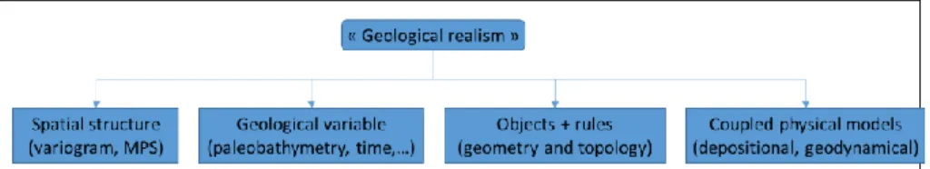
Figure 28.2: Summary of the various complementary ways to incorporate geolog-ical knowledge in earth models.
28.5 Conclusions and challenges
Several complementary ways exist to incorporate geological information in earth models (Fig. 28.2): spatial statistics, geological variables, geometry and to-pology of geological objects and explicit geological process modeling. Links exist between the random field and object-based frameworks in cases where the canoni-cal random field theory is applicable (e.g., homogeneous and stationary object
densities). This forms the rationale for most modeling methods where “small” ob-jects are treated though their (spatially correlated) equivalent properties at the rep-resentative elementary volume scale. “Large” objects are modeled explicitly using rules and parameters that incorporate geological principles and may be calibrated from data and analogs.
Although geostatistics has proven an invaluable theoretical framework to rigor-ously describe geological domains, it needs to be complemented by geological reasoning (sensu Frodeman 1995). Namely, considering discrete time steps ap-proximating geological history and geological variables which cannot be directly measured can significantly help generating more predictive geological models, which may not always have stationary statistical properties. Geometric and topo-logical interactions between objects have a direct connection to geotopo-logical history and prove a powerful tool to characterize geological domains.
From a physical modeling perspective, geometric object models allow to repre-sent small spatial features which can have a large impact on physical processes (Jackson et al. 2015; Julio et al. 2015b; Matthäi et al. 2007). This calls for specific developments in meshing and physical simulation, for example to better account for object features directly in the numerical code (Pichot et al. 2012). In the frame of inverse problems, sensitivity analysis is essential in practical studies. Theoreti-cally, specific methods integrating the probability of existence of objects also need to be considered more widely, such as random vector parameterization (Cherpeau et al. 2012), reversible jump Monte-Carlo Markov Chain simulation (Green 1995; Sambridge et al. 2012) or ensemble-based methods (Scheidt and Caers 2009). Both in forward and inverse physical models, an additional and significant chal-lenge is to better characterize the multi-sale interactions between geometrical and petrophysical parameterizations (basis functions and associated parameters val-ues).
28.6 Acknowledgements
The ideas expressed in this chapter owe much to Bruno Lévy, Albert Tarantola, Andre Journel and Jean-Laurent Mallet. Their encouragements, trust and critical remarks have been essential influences. I am also grateful to the graduate students and colleagues of the Research for Integrative Numerical Geology (RING) Team, especially my colleagues Pauline Collon and Paul Cupillard, for their multiple contributions to such a stimulating research environment. Discussions in the frame of the HIWAI ANR project led by Yann Capdeville also fed some of the ideas about scale expressed in this chapter. Last, but not least, at a time where research funding is getting more and more complex, I express my great appreciation to the academic and industrial sponsors of RING-Gocad Consortium for their continued support and to ASGA for its effective Consortium management.
28.7 References
Agterberg F. Geomathematics: Theoretical Foundations, Applications and Future Developments [Internet]. Cham: Springer International Publishing; 2014 [cited 2015 Aug 17]. Available from: http://link.springer.com/10.1007/978-3-319-06874-9
Allard D, Froidevaux R, Biver P. Conditional Simulation of Multi-Type Non Sta-tionary Markov Object Models Respecting Specified Proportions. Math. Geol. 2006 Nov;38(8):959–86.
Armstrong M, Galli A, Beucher H, Loc’h G, Renard D, Doligez B, et al. Plurigaussian simulations in geosciences. Springer Science & Business Media; 2011.
Aydin O, Caers JK. Quantifying structural uncertainty on fault networks using a marked point process within a Bayesian framework. Tectonophysics [Internet].
2017 May [cited 2017 May 9]; Available from:
http://linkinghub.elsevier.com/retrieve/pii/S0040195117301610
Berkowitz B, Balberg I. Percolation theory and its application to groundwater hy-drology. Water Resour. Res. 1993 Apr;29(4):775–94.
Boisvert JB, Manchuk JG, Deutsch CV. Kriging in the Presence of Locally Vary-ing Anisotropy UsVary-ing Non-Euclidean Distances. Math. Geosci. 2009 Jul;41(5):585–601.
Bonneau F, Caumon G, Renard P. Impact of a Stochastic Sequential Initiation of Fractures on the Spatial Correlations and Connectivity of Discrete Fracture Net-works. J. Geophys. Res. Solid Earth. 2016;121(8):5641–5658.
Bonneau F, Henrion V, Caumon G, Renard P, Sausse J. A methodology for pseu-do-genetic stochastic modeling of discrete fracture networks. Comput. Geosci. 2013 Jul;56:12–22.
Borghi A, Renard P, Jenni S. A pseudo-genetic stochastic model to generate karstic networks. J. Hydrol. 2012 Jan;414–415:516–29.
Bosch M, Mukerji T, Gonzalez EF. Seismic inversion for reservoir properties combining statistical rock physics and geostatistics: A review. GEOPHYSICS. 2010 Sep;75(5):75A165-75A176.
Botella A, Lévy B, Caumon G. Indirect unstructured hex-dominant mesh genera-tion using tetrahedra recombinagenera-tion. Comput. Geosci. 2016 Jun;20(3):437–51. Bourbiaux B, Basquet R, Cacas MC, Daniel JM, Sarda S. An integrated workflow to account for multi-scale fractures in reservoir simulation models: implementa-tion and benefits. Abu Dhabi Int. Pet. Exhib. Conf. 2002.
Cacace M, Blöcher G. MeshIt—a software for three dimensional volumetric meshing of complex faulted reservoirs. Environ. Earth Sci. 2015 Sep;74(6):5191– 209.
Caers J. Modeling uncertainty in the earth sciences. John Wiley & Sons; 2011. Calcagno P, Chilès J-P, Courrioux G, Guillen A. Geological modelling from field data and geological knowledge: Part I. Modelling method coupling 3D potential-field interpolation and geological rules. Phys. Earth Planet. Inter. 2008;171(1):147–57.
Cardiff M, Kitanidis PK. Bayesian inversion for facies detection: An extensible level set framework: LEVEL SETS FOR FACIES DETECTION. Water Resour. Res. 2009 Oct;45(10):n/a-n/a.
Caumon G. Towards stochastic time-varying geological modeling. Math. Geosci. 2010;42(5):555–69.
Caumon G, Collon-Drouaillet P, Le Carlier De Veslud C, Viseur S, Sausse J. Sur-face-based 3D modeling of geological structures. Math. Geosci. 2009;41(8):927– 45.
Caumon G, Gray G, Antoine C, Titeux M-O. Three-Dimensional Implicit Strati-graphic Model Building From Remote Sensing Data on Tetrahedral Meshes: The-ory and Application to a Regional Model of La Popa Basin, NE Mexico. Geosci. Remote Sens. IEEE Trans. On. 2013 Mar;51(3):1613–21.
Caumon G, Lepage F, Sword CH, Mallet J-L. Building and editing a sealed geo-logical model. Math. Geol. 2004;36(4):405–24.
Caumon G, Tertois A-L, Zhang L. Elements for stochastic structural perturbation of stratigraphic models. EAGE Pet. Geostat. 2007.
Charvin K, Gallagher K, Hampson GL, Labourdette R. A Bayesian approach to inverse modelling of stratigraphy, part 1: method. Basin Res. 2009 Feb;21(1):5– 25.
Cherpeau N, Caumon G. Stochastic structural modelling in sparse data situations. Pet. Geosci. 2015;21(4):233–47.
Cherpeau N, Caumon G, Caers J, Lévy B. Method for Stochastic Inverse Model-ing of Fault Geometry and Connectivity UsModel-ing Flow Data. Math. Geosci. 2012;44(2):147–68.
Cherpeau N, Caumon G, Lévy B. Stochastic simulations of fault networks in 3D structural modeling. Comptes Rendus Geosci. 2010;342(9):687–94.
Chiles JP. Fractal and geostatistical methods for modeling of a fracture network. Math. Geol. 1988;20(6):631–654.
Chiles J-P, Delfiner P. Geostatistics: modeling spatial uncertainty. 2nd ed. Hobo-ken, N.J: Wiley; 2012.
Clapp RG, Biondi BL, Claerbout JF. Incorporating geologic information into re-flection tomography. GEOPHYSICS. 2004 Mar;69(2):533–46.
Collon P, Bernasconi D, Vuilleumier C, Renard P. Statistical metrics for the char-acterization of karst network geometry and topology. Geomorphology. 2017 Apr;283:122–42.
Collon P, Pichat A, Kergaravat C, Botella A, Caumon G, Ringenbach J-C, et al. 3D modeling from outcrop data in a salt tectonic context: Example from the Inceyol minibasin, Sivas Basin, Turkey. Interpretation. 2016 Aug;4(3):SM17-SM31.
Collon-Drouaillet P, Henrion V, Pellerin J. An algorithm for 3D simulation of branchwork karst networks using Horton parameters and A*: Application to a syn-thetic case. Geol. Soc. Lond. Spec. Publ. 2012 Jan 1;370(1):295–306.
Corbel S, Wellmann JF. Framework for multiple hypothesis testing improves the use of legacy data in structural geological modeling. GeoResJ. 2015 Jun;6:202– 12.
Corre B, Thore P, de Feraudy V, Vincent G. Integrated Uncertainty Assessment For Project Evaluation and Risk Analysis. SPE Eur. Pet. Conf. Paris, France: So-ciety of Petroleum Engineers; 2000.
Cowan EJ, Beatson RK, Ross HJ, Fright WR, McLennan TJ, Evans TR, et al. Practical implicit geological modelling. Fifth Int. Min. Geol. Conf. 2003. p. 17–9. Cross TA, Lessenger MA. Construction and application of a stratigraphic inverse model. 1999;
Davis JL, Annan AP. GROUND-PENETRATING RADAR FOR HIGH-RESOLUTION MAPPING OF SOIL AND ROCK STRATIGRAPHY1. Geophys. Prospect. 1989;37(5):531–551.
Davy P, Le Goc R, Darcel C. A model of fracture nucleation, growth and arrest, and consequences for fracture density and scaling: A DISCRETE FRACTURE NETWORK MODEL. J. Geophys. Res. Solid Earth. 2013 Apr;118(4):1393–407. Deutsch CV, Wang L. Hierarchical object-based stochastic modeling of fluvial reservoirs. Math. Geol. 1996;28(7):857–80.
Efendiev Y, Galvis J, Hou TY. Generalized multiscale finite element methods (GMsFEM). J. Comput. Phys. 2013 Oct;251:116–35.
Elrafie EA, White JP, Awami FH. The Event Solution--A New Approach for Ful-ly Integrated Studies Covering Uncertainty AnaFul-lysis and Risk Assessment. SPE-105276-PA. 2008 Oct 1;
Farmer CL. Geological Modelling and Reservoir Simulation. In: Iske A, Randen T, editors. Math. Methods Model. Hydrocarb. Explor. Prod. [Internet]. Berlin, Heidelberg: Springer Berlin Heidelberg; 2005. p. 119–212. Available from: http://dx.doi.org/10.1007/3-540-26493-0_6
Fetkovich MJ. Decline Curve Analysis Using Type Curves. SPE-4629-PA. 1980 Jun 1;
Frank T, Tertois A-L, Mallet J-L. 3D-reconstruction of complex geological inter-faces from irregularly distributed and noisy point data. Comput. Geosci. 2007;33(7):932–43.
Frodeman R. Geological reasoning: Geology as an interpretive and historical sci-ence. Geol. Soc. Am. Bull. 1995 Aug 1;107(8):960–8.
Fullagar P, Hughes N, Paine J. Drilling-constrained 3D gravity interpretation. Explor. Geophys. 2000 Jun 1;31(1/2):17–23.
Gallagher K, Charvin K, Nielsen S, Sambridge M, Stephenson J. Markov chain Monte Carlo (MCMC) sampling methods to determine optimal models, model resolution and model choice for Earth Science problems. Mar. Pet. Geol. 2009 Apr;26(4):525–35.
Georgsen F, Røe P, Syversveen AR, Lia O. Fault displacement modelling using 3D vector fields. Comput. Geosci. 2012 Jan 7;16(2):247–59.
Gjøystdal H, Reinhardsen JE, Åstebøl K. COMPUTER REPRESENTATION OF COMPLEX 3‐ D GEOLOGICAL STRUCTURES USING A NEW “SOLID MODELING” TECHNIQUE*. Geophys. Prospect. 1985;33(8):1195–211. Goovaerts P. Geostatistics for natural resources evaluation. Oxford University Press; 1997.
Graham GH, Jackson MD, Hampson GJ. Three-dimensional modeling of clinoforms in shallow-marine reservoirs: Part 1. Concepts and application. AAPG Bull. 2015 Jun;99(06):1013–47.
Green PJ. Reversible jump Markov chain Monte Carlo computation and Bayesian model determination. Biometrika. 1995;82(4):711–32.
Gross H, Boucher AF. Geostatistics on Unstructured Grid-Coordinate Systems, Connections and Volumes. Pet. Geostat. 2015 [Internet]. 2015 [cited 2016 Jul 13].
Available from:
http://www.earthdoc.org/publication/publicationdetails/?publication=82214 Guardiano FB, Srivastava RM. Multivariate geostatistics: beyond bivariate mo-ments. Geostat. Troia’92 [Internet]. Springer; 1993 [cited 2017 Apr 30]. p. 133– 144. Available from: http://link.springer.com/chapter/10.1007/978-94-011-1739-5_12
Gumiaux C, Gapais D, Brun J. Geostatistics applied to best-fit interpolation of orientation data. Tectonophysics. 2003 Dec;376(3–4):241–59.
Haldorsen HH, Lake LW. A New Approach to Shale Management in Field-Scale Models. SPE-10976-PA. 1984 Aug 1;
Hale D. Methods to compute fault images, extract fault surfaces, and estimate fault throws from 3D seismic images. GEOPHYSICS. 2013;78(2):O33–43. Henrion V, Caumon G, Cherpeau N. ODSIM: An Object-Distance Simulation Method for Conditioning Complex Natural Structures. Math. Geosci. 2010;42(8):911–24.
Hillier MJ, Schetselaar EM, de Kemp EA, Perron G. Three-Dimensional Model-ling of Geological Surfaces Using Generalized Interpolation with Radial Basis Functions. Math. Geosci. 2014 Nov;46(8):931–53.
Holden L, Hauge R, Skare Ø, Skorstad A. Modeling of fluvial reservoirs with ob-ject models. Math. Geol. 1998;30(5):473–496.
Holden L, Mostad P, Nielsen BF, Gjerde J, Townsend C, Ottesen S. Stochastic structural modeling. Math. Geol. 2003;35(8):899–914.
Hollund K, Mostad P, Fredrik Nielsen B, Holden L, Gjerde J, Grazia Contursi M, et al. Havana—a fault modeling tool. Nor. Pet. Soc. Spec. Publ. 2002;11:157–71. Hu LY, Chugunova T. Multiple-point geostatistics for modeling subsurface heter-ogeneity: A comprehensive review: REVIEW OF MULTIPLE POI. Water Resour. Res. [Internet]. 2008 Nov [cited 2017 Apr 30];44(11). Available from: http://doi.wiley.com/10.1029/2008WR006993
Jackson CA-L, Rotevatn A. 3D seismic analysis of the structure and evolution of a salt-influenced normal fault zone: A test of competing fault growth models. J. Struct. Geol. 2013 Sep;54:215–34.
Jackson M, Percival J, Mostaghimi P, Tollit B, Pavlidis D, Pain C, et al. Reservoir Modeling for Flow Simulation by Use of Surfaces, Adaptive Unstructured Mesh-es, and an Overlapping-Control-Volume Finite-Element Method. SPE-163633-PA. 2015 May 1;
Jackson MD, Hampson GJ, Saunders JH, El-Sheikh A, Graham GH, Massart BYG. Surface-based reservoir modelling for flow simulation. Geol. Soc. Lond. Spec. Publ. 2014;387(1):271–92.
Jenny P, Lee S., Tchelepi H. Multi-scale finite-volume method for elliptic prob-lems in subsurface flow simulation. J. Comput. Phys. 2003 May;187(1):47–67. Jessell M, Ailleres L, De Kemp E, Lindsay M, Wellmann JF, Hillier M, et al. Next generation three-dimensional geologic modeling and inversion. Econ. Geol. 2014;18:261–272.
Jessell MW, Ailleres L, de Kemp EA. Towards an integrated inversion of geoscientific data: What price of geology? Tectonophysics. 2010 Jul;490(3– 4):294–306.
Jessell MW, Valenta RK. Structural geophysics: integrated structural and geo-physical modelling. Comput. Methods Geosci. 1996;15:303–24.
Jeulin D. MODELLING RANDOM MEDIA. Image Anal. Stereol. 2002;21(4):31. Jeulin D. Morphology and effective properties of multi-scale random sets: A re-view. Comptes Rendus Mécanique. 2012 Apr;340(4–5):219–29.
Journel AG. Beyond covariance: the advent of multiple-point geostatistics. Geostat. Banff 2004. 2005;225–233.
Julio C, Caumon G, Ford M. Sampling the uncertainty associated with segmented normal fault interpretation using a stochastic downscaling method. Tectonophysics. 2015a Jan 12;639:56–67.
Julio C, Caumon G, Ford M. Impact of the en echelon fault connectivity on reser-voir flow simulations. Interpretation. 2015b Nov;3(4):SAC23-SAC34.
Karimi-Fard M, Durlofsky LJ. A general gridding, discretization, and coarsening methodology for modeling flow in porous formations with discrete geological fea-tures. Adv. Water Resour. 2016 Oct;96:354–72.
Kedzierski P, Mallet JL, Caumon G. Combining Stratigraphic and Sedimentological Information for Realistic Facies Simulations. EAGE Pet. Geostat. 2007.
King PR, Buldyrev SV, Dokholyan NV, Havlin S, Lee Y, Paul G, et al. Predicting oil recovery using percolation theory. Pet. Geosci. 2001 Mar 1;7(S):S105–7. Kolditz O, Bauer S, Bilke L, Böttcher N, Delfs JO, Fischer T, et al. OpenGeoSys: an open-source initiative for numerical simulation of thermo-hydro-mechanical/chemical (THM/C) processes in porous media. Environ. Earth Sci. 2012 Sep;67(2):589–99.
Labourdette R. ‘LOSCS’ Lateral Offset Stacked Channel Simulations: Towards geometrical modelling of turbidite elementary channels: Lateral offset stacked channels simulations,. Basin Res. 2008 Jun 4;20(3):431–44.
Lallier F, Caumon G, Borgomano J, Viseur S, Royer J-J, Antoine C. Uncertainty assessment in the stratigraphic well correlation of a carbonate ramp: Method and application to the Beausset Basin, SE France. Comptes Rendus Geosci. 2016;348(7):499–509.
Lantuéjoul C. Boolean model. In: Lantuéjoul C, editor. Geostat. Simul. Models Algorithms [Internet]. Berlin, Heidelberg: Springer Berlin Heidelberg; 2002. p. 153–66. Available from: http://dx.doi.org/10.1007/978-3-662-04808-5_13
Laurent G, Ailleres L, Grose L, Caumon G, Jessell M, Armit R. Implicit modeling of folds and overprinting deformation. Earth Planet. Sci. Lett. 2016 Dec 15;456:26–38.
Laurent G, Caumon G, Bouziat A, Jessell M. A parametric method to model 3D displacements around faults with volumetric vector fields. Tectonophysics. 2013 Apr 1;590:83–93.
Lecour M, Cognot R, Duvinage I, Thore P, Dulac J-C. Modelling of stochastic faults and fault networks in a structural uncertainty study. Pet. Geosci. 2001 Mar 1;7(S):S31–42.
Lelièvre PG, Farquharson CG. Integrated Imaging for Mineral Exploration. Integr. Imaging Earth [Internet]. John Wiley & Sons, Inc; 2016. p. 137–66. Available from: http://dx.doi.org/10.1002/9781118929063.ch8
Linde N, Doetsch J. Joint Inversion in Hydrogeophysics and Near-Surface Geo-physics. Integr. Imaging Earth [Internet]. John Wiley & Sons, Inc; 2016. p. 117– 35. Available from: http://dx.doi.org/10.1002/9781118929063.ch7
Linde N, Renard P, Mukerji T, Caers J. Geological realism in hydrogeological and geophysical inverse modeling: A review. Adv. Water Resour. 2015 Dec;86:86– 101.
Lindsay MD, Jessell MW, Ailleres L, Perrouty S, de Kemp E, Betts P. Geodiversity: Exploration of 3D geological model space. Tectonophysics. 2013;594:27–37.
Liu GR, Gu YT. An introduction to meshfree methods and their programming. Dordrecht ; New York: Springer; 2005.
Ma Y, Hale D, Gong B, Meng Z (Joe). Image-guided sparse-model full waveform inversion. GEOPHYSICS. 2012;77(4):R189–98.
Maier C, Karimi-Fard M, Lapene A, Durlofsky LJ. An MPFA-based Dual Contin-uum–Discrete Feature Model for Simulation of Flow in Fractured Reservoirs. ECMOR XV-15th Eur. Conf. Math. Oil Recovery [Internet]. 2016 [cited 2017
May 14]. Available from:
http://www.earthdoc.org/publication/publicationdetails/?publication=86292 Mallet JL. Geomodeling. Oxford University Press, USA; 2002.
Mallet J-L. Elements of mathematical sedimentary geology: The GeoChron mod-el. EAGE publications; 2014.
Manchuk J, Leuangthong O, Deutsch CV. Direct geostatistical simulation on un-structured grids. Geostat. Banff 2004 [Internet]. Springer; 2005 [cited 2017 Apr 30]. p. 85–94. Available from: http://link.springer.com/chapter/10.1007/978-1-4020-3610-1_9
Mannseth T. Relation Between Level Set and Truncated Pluri-Gaussian Method-ologies for Facies Representation. Math. Geosci. 2014 Aug;46(6):711–31. Mariethoz G, Caers J. Multiple-point geostatistics: stochastic modeling with train-ing images. John Wiley & Sons; 2014.
Mariethoz G, Comunian A, Irarrazaval I, Renard P. Analog-based meandering
channel simulation: ANALOG-BASED MEANDERING CHANNEL
SIMULATION. Water Resour. Res. 2014 Feb;50(2):836–54.
de Marsily G, Delay F, Gonçalvès J, Renard P, Teles V, Violette S. Dealing with spatial heterogeneity. Hydrogeol. J. 2005 Mar;13(1):161–83.
Massonnat GJ. Breaking of a paradigm: geology can provide 3D complex proba-bility fields for stochastic facies modelling. SPE Annu. Tech. Conf. Exhib. Society of Petroleum Engineers; 1999.
Matthäi SK, Geiger S, Roberts SG, Paluszny A, Belayneh M, Burri A, et al. Nu-merical simulation of multi-phase fluid flow in structurally complex reservoirs. Geol. Soc. Lond. Spec. Publ. 2007;292(1):405–29.
Meju MA, Gallardo LA. Structural Coupling Approaches in Integrated Geophysi-cal Imaging. Integr. Imaging Earth [Internet]. John Wiley & Sons, Inc; 2016. p. 49–67. Available from: http://dx.doi.org/10.1002/9781118929063.ch4
Melnikova Y, Zunino A, Lange K, Cordua KS, Mosegaard K. History Matching Through a Smooth Formulation of Multiple-Point Statistics. Math. Geosci. 2015 May;47(4):397–416.
Merland R, Caumon G, Lévy B, Collon-Drouaillet P. Voronoi grids conforming to 3D structural features. Comput. Geosci. 2014 Aug;18(3–4):373–83.
Michael HA, Li H, Boucher A, Sun T, Caers J, Gorelick SM. Combining geolog-ic-process models and geostatistics for conditional simulation of 3-D subsurface heterogeneity. Water Resour. Res. 2010;46(5):W05527.
Moës N, Gravouil A, Belytschko T. Non-planar 3D crack growth by the extended finite element and level sets-Part I: Mechanical model: NON-PLANAR 3D CRACK GROWTH-PART I. Int. J. Numer. Methods Eng. 2002 Apr 20;53(11):2549–68.
Mondal A, Efendiev Y, Mallick B, Datta-Gupta A. Bayesian uncertainty quantifi-cation for flows in heterogeneous porous media using reversible jump Markov chain Monte Carlo methods. Adv. Water Resour. 2010 Mar;33(3):241–56. Moorkamp M, Heincke B, Jegen M, Hobbs RW, Roberts AW. Joint Inversion in Hydrocarbon Exploration. Integr. Imaging Earth [Internet]. John Wiley & Sons,
Inc; 2016. p. 167–89. Available from:
Mosegaard K. Quest for consistency, symmetry, and simplicity — The legacy of Albert Tarantola. GEOPHYSICS. 2011 Sep;76(5):W51–61.
Mosegaard K, Hansen TM. Inverse Methods. Integr. Imaging Earth [Internet]. John Wiley & Sons, Inc; 2016. p. 7–27. Available from: http://dx.doi.org/10.1002/9781118929063.ch2
Møyner O, Lie K-A. The Multiscale Finite-Volume Method on Stratigraphic Grids. SPE-163649-PA. 2014 Oct 1;
Mustapha H. G23FM: a tool for meshing complex geological media. Comput. Geosci. 2011;15(3):385–97.
Nobakht M, Clarkson CR, Kaviani D. New type curves for analyzing horizontal well with multiple fractures in shale gas reservoirs. J. Nat. Gas Sci. Eng. 2013 Jan;10:99–112.
Noetinger B. An Explicit Formula for Computing the Sensitivity of the Effective Conductivity of Heterogeneous Composite Materials to Local Inclusion Transport Properties and Geometry. Multiscale Model. Simul. 2013 Jan 1;11(3):907–24. Oda M. An equivalent continuum model for coupled stress and fluid flow analysis in jointed rock masses. Water Resour. Res. 1986;22(13):1845–56.
Oliver DS, Chen Y. Recent progress on reservoir history matching: a review. Comput. Geosci. 2011 Jan;15(1):185–221.
Paasche H. Post-Inversion Integration of Disparate Tomographic Models by Mod-el Structure Analyses. Integr. Imaging Earth [Internet]. John Wiley & Sons, Inc; 2016. p. 69–91. Available from: http://dx.doi.org/10.1002/9781118929063.ch5 Parquer M, Collon P, Caumon G. Conditioning channel backward migration mod-eling to seismic data. 78th EAGE Conf. Exhib. 2016 Proc. Vienna, Austria; 2016. Pellerin J, Botella A, Bonneau F, Mazuyer A, Chauvin B, Lévy B, et al. RINGMesh: A programming library for developing mesh-based geomodeling ap-plications. Comput. Geosci. [Internet]. 2017 Mar [cited 2017 May 1]; Available from: http://linkinghub.elsevier.com/retrieve/pii/S0098300417302637
Pellerin J, Caumon G, Julio C, Mejia-Herrera P, Botella A. Elements for measur-ing the complexity of 3D structural models: Connectivity and geometry. Comput. Geosci. 2015 Mar;76:130–40.
Pellerin J, Lévy B, Caumon G. Toward Mixed-element Meshing based on Re-stricted Voronoi Diagrams. Procedia Eng. 2014;82:279–90.
Perrin M, Rainaud J-F. Shared Earth Modeling: Knowledge Driven Solutions for Building and Managing Subsurface 3D Geological Models. Editions Technip; 2013.
Perrouty S, Lindsay MD, Jessell MW, Aillères L, Martin R, Bourassa Y. 3D mod-eling of the Ashanti Belt, southwest Ghana: Evidence for a litho-stratigraphic con-trol on gold occurrences within the Birimian Sefwi Group. Ore Geol. Rev. 2014 Dec;63:252–64.
Pichot G, Erhel J, de Dreuzy J-R. A Generalized Mixed Hybrid Mortar Method for Solving Flow in Stochastic Discrete Fracture Networks. SIAM J. Sci. Comput. 2012 Jan;34(1):B86–105.
Pyrcz MJ, Boisvert JB, Deutsch CV. ALLUVSIM: A program for event-based stochastic modeling of fluvial depositional systems. Comput. Geosci. 2009 Aug;35(8):1671–85.
Pyrcz MJ, Catuneanu O, Deutsch CV. Stochastic surface-based modeling of turbidite lobes. AAPG Bull. 2005 Feb;89(2):177–91.
Pyrcz MJ, Deutsch CV. Geostatistical reservoir modeling. Oxford university press; 2014.
Pyrcz MJ, Sech RP, Covault JA, Willis BJ, Sylvester Z, Sun T, et al. Stratigraphic rule-based reservoir modeling. Bull. Can. Pet. Geol. 2015 Dec;63(4):287–303. Renard P, Straubhaar J, Caers J, Mariethoz G. Conditioning facies simulations with connectivity data. Math. Geosci. 2011;43(8):879–903.
Ringrose P, Bentley M. Reservoir Model Design [Internet]. Dordrecht: Springer
Netherlands; 2015 [cited 2017 Apr 27]. Available from:
http://link.springer.com/10.1007/978-94-007-5497-3
Rongier G, Collon P, Renard P. A geostatistical approach to the simulation of stacked channels. Mar. Pet. Geol. [Internet]. 2017 Feb [cited 2017 Feb 21]; Avail-able from: http://linkinghub.elsevier.com/retrieve/pii/S0264817217300375 Rongier G, Collon-Drouaillet P, Filipponi M. Simulation of 3D karst conduits with an object-distance based method integrating geological knowledge. Geomor-phology. 2014 Jul;217:152–64.
Ruiu J, Caumon G, Viseur S. Semiautomatic interpretation of 3D sedimentological structures on geologic images: An object-based approach. Inter-pretation. 2015 Jul 16;3(3):SX63-SX74.
Ruiu J, Caumon G, Viseur S. Modeling Channel Forms and Related Sedimentary Objects Using a Boundary Representation Based on Non-uniform Rational B-Splines. Math. Geosci. 2016;48(3):259–84.
Sambridge M, Bodin T, Gallagher K, Tkalcic H. Transdimensional inference in the geosciences. Philos. Trans. R. Soc. Math. Phys. Eng. Sci. 2012 Dec 31;371(1984):20110547–20110547.
Sanderson DJ, Nixon CW. The use of topology in fracture network characteriza-tion. J. Struct. Geol. 2015 Mar;72(0):55–66.
Sava P, Revil A, Karaoulis M. High definition cross-well electrical resistivity im-aging using seismoelectric focusing and image-guided inversion. Geophys. J. Int. 2014 Jun 26;198(2):880–94.
Scheidt C, Caers J. Representing Spatial Uncertainty Using Distances and Ker-nels. Math. Geosci. 2009 May;41(4):397–419.
Scheidt C, Fernandes AM, Paola C, Caers J. Quantifying natural delta variability using a multiple-point geostatistics prior uncertainty model: DELTA VARIABILITY AND GEOSTATISTICS. J. Geophys. Res. Earth Surf. 2016 Oct;121(10):1800–18.
Sech RP, Jackson MD, Hampson GJ. Three-dimensional modeling of a shoreface-shelf parasequence reservoir analog: Part 1. Surface-based modeling to capture high-resolution facies architecture. AAPG Bull. 2009 Sep;93(9):1155–81. Shtuka A, Samson P, Mallet JL. Petrophysical Simulation Within an Object-Based Reservoir Model. SPE-35480-MS. SPE: Society of Petroleum Engineers; 1996. Srivastava RM, Frykman P, Jensen M. Geostatistical simulation of fracture net-works. Geostat. Banff 2004. 2005;295–304.
Stroet CBM te, Snepvangers JJJC. Mapping Curvilinear Structures with Local An-isotropy Kriging. Math. Geol. 2005 Aug;37(6):635–49.
Thiele ST, Jessell MW, Lindsay M, Ogarko V, Wellmann JF, Pakyuz-Charrier E. The topology of geology 1: Topological analysis. J. Struct. Geol. 2016a Oct;91:27–38.
Thiele ST, Jessell MW, Lindsay M, Wellmann JF, Pakyuz-Charrier E. The topol-ogy of geoltopol-ogy 2: Topological uncertainty. J. Struct. Geol. 2016b Oct;91:74–87. Vallet B, Lévy B. Spectral geometry processing with manifold harmonics. Com-put. Graph. Forum. Wiley Online Library; 2008. p. 251–60.
Viseur S. Caracterisation de reservoirs turbiditiques: simulations stochastiques ba-sees-objet de chenaux meandriformes (10 fig.). Bull. Soc. Geol. Fr. 2004;175(1):11–20.
Watson TA, Doherty JE, Christensen S. Parameter and predictive outcomes of model simplification: Outcomes of Model Simplification. Water Resour. Res. 2013 Jul;49(7):3952–77.
Wellmann JF, Horowitz FG, Schill E, Regenauer-Lieb K. Towards incorporating uncertainty of structural data in 3D geological inversion. Tectonophysics. 2010 Jul;490(3–4):141–51.
Wellmann JF, Lindsay M, Poh J, Jessell M. Validating 3-D Structural Models with Geological Knowledge for Improved Uncertainty Evaluations. Eur. Geosci. Union Gen. Assem. 2014 EGU Div. Energy Resour. Environ. ERE. 2014;59(0):374–81. Williams GJJ, Mansfield M, MacDonald DG, Bush MD. Top-Down Reservoir Modelling. SPE-89974-MS. SPE: Society of Petroleum Engineers; 2004.
Xu W. Conditional curvilinear stochastic simulation using pixel-based algorithms. Math. Geol. 1996;28(7):937–949.
Zagayevskiy Y, Deutsch CV. Multivariate grid-free geostatistical simulation with point or block scale secondary data. Stoch. Environ. Res. Risk Assess. 2016 Aug;30(6):1613–33.
Zaytsev V, Biver P, Wackernagel H, Allard D. Change-of-Support Models on Ir-regular Grids for Geostatistical Simulation. Math. Geosci. 2016 May;48(4):353– 69.
Zehner B, Börner JH, Görz I, Spitzer K. Workflows for generating tetrahedral meshes for finite element simulations on complex geological structures. Comput. Geosci. 2015 Jun;79:105–17.
Zheglova P, Farquharson CG, Hurich CA. 2-D reconstruction of boundaries with level set inversion of traveltimes. Geophys. J. Int. 2013 Feb 1;192(2):688–98. Zhou H, Gómez-Hernández JJ, Li L. Inverse methods in hydrogeology: Evolution and recent trends. Adv. Water Resour. 2014a Jan;63(0):22–37.
Zhou J, Revil A, Karaoulis M, Hale D, Doetsch J, Cuttler S. Image-guided inver-sion of electrical resistivity data. Geophys. J. Int. 2014b Apr 1;197(1):292–309.