HAL Id: insu-01104244
https://hal-insu.archives-ouvertes.fr/insu-01104244
Submitted on 16 Jan 2015HAL is a multi-disciplinary open access archive for the deposit and dissemination of sci-entific research documents, whether they are pub-lished or not. The documents may come from teaching and research institutions in France or abroad, or from public or private research centers.
L’archive ouverte pluridisciplinaire HAL, est destinée au dépôt et à la diffusion de documents scientifiques de niveau recherche, publiés ou non, émanant des établissements d’enseignement et de recherche français ou étrangers, des laboratoires publics ou privés.
TDIP imaging of watershed over crystalline basement
Christian Camerlynck, L Longuevergne, C Roques
To cite this version:
Christian Camerlynck, L Longuevergne, C Roques. TDIP imaging of watershed over crystalline base-ment. 3rd International Workshop on Induced Polarization, Apr 2014, Oléron, France. 2 p., 3rd International Workshop on Induced Polarization. Abstract book. �insu-01104244�
3rd International Workshop on Induced Polarization 6 – 9 April 2014 (Ile d’Oléron, France)
TDIP imaging of watershed over crystalline basement
C. Camerlynck(1), L. Longuevergne(2) and C. Roques(2)
(1) Sorbonne Université, UPMC-Université Paris 6, UMR 7619 Metis, Paris, France (2) Université Rennes 1, Géosciences Rennes, UMR 6118, Rennes, France
Aquifers located in Brittany (Western France) are set over crystalline geology. Water is generally flowing through highly permeable fractures. We show the TDIP potentiality in picturing hydro-geophysical contexts. Those preliminary results need now to be confirmed by both sample measurement and in-situ characterizations.
Saint-Brice-en-Cogles (Northern Brittany, N48.422°, W1.377°)
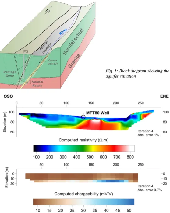
The geological context comprises fractured schists with granite inclusions, located on a granite basement. Normal faults from Caledonian to Hercinian era define a horst/graben situation (Fig. 1). A borehole drilled thanks to the CASPAR program produced 43 m3 h–1 during a preli-minary pumping test, showing the high potentiality for consumable water production.
Fig. 1: Block diagram showing the aquifer situation.
Fig. 2: Saint-Brice. a) Computed resistivity (Wenner-Schlumberger array, inter-electrode spacing = 3m). b) Computed chargeability (dipole-dipole array, inter-electrode spacing = 3 m).
3rd International Workshop on Induced Polarization 6 – 9 April 2014 (Ile d’Oléron, France) Several electrical resistivity tomographies were performed in the west-east direction (Fig. 2). While the resistivity tomography shows a striking picture of the recharge zone associated with a conductive anomaly, the TDIP results make not coincide the highest chargeability with the MFT80 borehole location (close to productive F3 borehole) in which pyrite have been seen associated with fracturing in drilled sample. The association of fractures (so hydraulic transmissivity) with high chargeability response linked to pyrite is therefore to be discussed, with probable oxidation phenomena clearly visible on core drilling samples (Fig. 3).
Fig. 3: MFT80 core drilling. Oxidized (top, from 25 m depth) and unaltered (bottom) schist samples.
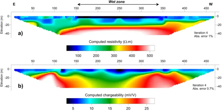
Guidel (Southern Brittany, N47.755°, W3.481°)
An unexploited aquifer could be consider in a pristine state, at the opposite of the more well-known Ploemeur aquifer located some kilometres to the east and pumped for the last 30 years. At least one borehole shows some artesian condition. A wet zone is probably supplied from below, with surface water properties very similar to those of deep water. Electrical resistivity tomography shows a discrepancy between resistivity and chargeability, both in measurements and inversed values (Fig. 4). We think that higher permeability and water circulations can be associated with a decreasing of induced polarization properties, probably through oxidation of polarisable materials.
Fig. 4: Guidel (Wenner-Schlumberger array, inter-electrode spacing = 5m). a) Computed resistivity. b) Computed chargeability.