Confrontation, Compromise and Reconstruction of The Walled
City of Shahjahanabad
By
Ajit Singh
Bachelor of Architecture
School of Planning and Architecture Delhi, India
June 2002
Submitted to the Department of Architecture in Partial Fulfillment of the Requirements for the Degree Master of Science in Architecture Studies
at the
Massachusetts Institute of Technology June 2006
@ 2006 Ajit Singh. All rights reserved
The author hereby grants to M.I.T permission to reproduce and to distribute publicly paper and electronic copies of this thesis document in whole or in part in any medium now known or hereafter created.
Signature of Author:
Ajit Singh Department of Architecture May 25, 2006
Certified by:
Michael Dennis Professor of Architecture, MIT
Accepted by:
Julian Beinart ofessor of Architieture, MIT Chairman, Department Committee on Graduate Studies Course IV
MASSACHUSETTS INSTITUTE OF TECHNOLOGY
RorCH11
JUN 15 2006
Confrontation, Compromise and Reconstruction of
The Walled City of Shahjahanabad
By Ajit Singh
Thesis Committee Michael Dennis
Professor of Architecture
Department of Architecture, MIT
John de Monchaux
Professor of Architecture and Planning, MIT Department of Architecture and Planning, MIT Department of Urban Studies and Planning, MIT
Readers
Julian Beinart
Professor of Architecture, MIT Chairman, Department Committee on Graduate Studies Course IV
Eran Ben Joseph
Associate Professor Landscape Architecture, MIT
Confrontation, Compromise and Reconstruction of The Walled
City of Shahjahanabad
Abstract:
Cities offer a platform for cultural, social, physical and economic co-existence and conflict. Many traditional cities of India, which were conceived on the basis of relative autonomy of the existing societal structure, got transformed in to complex, fragmentary patterns of urban development due to their failure to support continuous population pressure and new trends of urbanization. One of these cities, Shahjahanabad (commonly known as Old Delhi), stands out as one of the perfect examples. The walled city of Shahjahanabad initially evolved on the basis of formal geometries of axial planning, and later got transformed in to a chaotic hub of complex form; initially due to the conscious neglect by the British colonialism and later due to endless problems generated by human immigration.
Although, the walled city is known for its historical significance due to numerous architectural monuments, the indigenous settlement is taboocd as "Old Delhi" due to its persistent socio- cultural patterns that isolate the traditional core of Delhi from rest of the city structure. Nonetheless, the walled city of Shahjahanabad is characterized by its introvert nature of public activities bolstered by specialized bazaars and indigenous neighborhoods (Mohallas) structured around religious sanctuaries. Although the traditional core is known for its local economy, the inner city continues poses serious threats of inner traffic congestion, excessive commercialization. Though there have been numerous efforts to decongest and revitalize the traditional core, all the efforts seemed too shortsighted to capture the genesis of all the problems; the problems which exists beyond the city peripheries, to the largely urban and economic growth of the city. The thesis tries to address the inner city issues and problems of the walled city of Shahjahanabad, which are largely because of its separation, and isolation from the rest of city growth. On the basis of problem analysis the research argues that the problems of the historic core need not follow "city revitalization" process, but needs to adopt city "integration process", which would not only provide important city services through urban design interventions, but also provide solutions to many inner city problems.
The growth pattern of Shahjahanabad exhibit various historical layers, changes over the period of time due to shifting and concentration of forces, which in turn has resulted in the fragmented landscapes along its outer peripheries. The thesis considers these spaces as important transitional spaces, which needs to be redeveloped in order to integrate segregated core of Shahjahanabad in to a cohesive center of National Capital Region (NCR), Delhi.
The thesis poses a larger question of how citywide planning strategies and macro level urban design interventions can revive the traditional core of Shahjahanabad, the city cores which has faced tremendous pressures of traffic congestion and disruptive land use patterns.
Thesis Supervisor: Michael Dennis Title: Professor of Architecture, MIT
Acknowledgements
This thesis is made possible through the generous contributions of several exceptional people. My thanks are due to:
Prof. Michael Dennis, my thesis advisor, who inspired me, supported me and assisted me continuously throughout my research work.
Prof. Julian Beinart for patiently listening to me, and potentially guiding me thorough the design development process. He raised intuitive questions of inquiry, which helped me to narrow down my research questions to seek concrete proposal.
Prof. John de Mochaux for his for his profound insights and astute observations, which guided me to refine my research questions at every step of thesis development.
Eran Ben Joseph for his timely critics, which helped to look forwards the final presentation.
Jasbir Sawhney for his timely guidance, who helped me answer some of the grounded questions. I am really grateful for his enthusiasm towards my thesis research. His support has really helped me to explore multiplenary issues of transportation and conservation based development of the walled city.
My friends at MIT and back at home, who supported me and helped me with the basic data collection.
My family for the wholehearted support towards the entire process of thesis formation.
Table of Contents
Acknowledgment 4Chapter 1 Introduction
1.1 Objective 8 1.2 Prologue 1.3 Concern1.4 An Evolution of Indian City Experience 1.5 Shahjahanabad (Old Delhi)
1.6 Need Identification 1.7 Thesis goals
1.8 Thesis Organization and Research Methodology
Chapter 2 Shahjahanabad: Changing perception of its landscapes
18
2.1 The Walled City of Shahjahanabad 2.2 Delhi in Transition
2.3 The Seven Cities of Delhi 2.4 Evolution of Shahjahanabad
2.5 Shahjahanabad and its Urban Precedents
2.6 Mughal Landscapes and their Changing Perception 2.7 Colonialism
2.8 Evolution of New Delhi and the context of Old Delhi (Shahjahanabad) 2.9 Imperial Delhi and Identity Conflicts
2.10 Post Independent period- Nationalism and Creating National Identity 2.11 Post Independent Period: Creation of Indigenous Modern
Chapter 3 Analyzing Current Urban Design Issues and
50
problems of Shahjahanabad.
3.1 "Dilli Ki Politics"- Politics of Delhi
3.2 The Problems of Urban Backyards: The underutilized Urban Voids at the City Edge.
3.3 Unabated Commercialization 3.4 Traffic and Transport
3.5 Incompatible Land Uses and functional conflict 3.6 Physical Barriers to Urban Expansion
3.7 Conservation by Special Developments, not by Special Controls 3.8 Non-Uniformity in density patterns
3.8.1 Re-densification of Lutyen's Zone
Chapter 4 Mapping City Gates as important nodes:
69
Analyzing their problems and design potentials
4.1 Development Matrix 4.2 Turkman Gate
4.3 Kashmiri Gate and Civil lines 4.4 Delhi Gates
4.5 Ajmeri Gate 4.6 Lahori Gate
4.7 Red Fort and Yamuna Front
Chapter 5 Proposals for Reconstructing Shahjahanabad:
78
5.1 Vision Statement of the Historic City of Shahjahanabad
5.2 Macro level design interventions to Integrate Shahjahanabad as a Traditional core
5.2.1 Macro level strategies to integrate open fragmented spaces in to a comprehensible design solutions
5.2.2 Open Water Channels: Sources for Creating Ecological Linkages 5.2.3 Utilizing Water Channels in to a non-vehicular zones of Movement
patterns.
5.2.4 Creating Ecological Bridges, Redefining the role of Ridge as a City eco-vertebrate
5.2.5 Shahjahanabad Reflecting Yamuna River front
5.2.5.1 Developing economical connections -Delhi Common wealth games as a tool to regenerate river edge.
General Master Plan Defining Urban Ring
Developing Urban Connections to integrate the historical Precinct Civic Axis
5.4.1.1 Garden and Urban Design
5.4.1.2 Design principles to treat the Famous Gates of Shahjahanabad as Physical Field of Artifacts.
5.4.2 Cultural Axis 5.4.3 Cultural Tourism 5.4.4 Public Axis 5.4.5 Institutional Axis
5.5 Conservational Development of Shahjahanabad 5.5.1 Urban Renewal and Traffic
5.5.2 Urban Renewal and Preservation of Monuments 5.5.3 Red fort 5.6 Traffic Plan 5.6.1 5.6.2 5.6.3 Final Remarks Bibliography
Macro level Traffic Design
Walled Gates as Transportation Nodes
Converting Streets in to Pedestrian Thoroughfares 5.3
5.3.1
5.4 5.4.1
1 Chapter 1: Introduction
1.1 Objective:
This thesis identifies the edges of the walled city of Shahjahanabad as the crucial transitional zone of recognizance, which needs to be reevaluated in order to solve inner city problems of the walled city of Shahjahanabad. The research concludes in to an urban design proposal, which reconstitutes the incongruous structure of the walled city in to a comprehensible, legitimate and spatial form.
1.2 Prologue:
As India has moved closer to being a commercial and industrial society, historic cities have far exceeded their capacities in terms of space, services and facilities. This has resulted in a gradual erosion and distortion of the fabric of these cities beyond recognition. One of these cities, Shahjahanabad, provides valuable lessons to contemporary Indian city planners, even though this lesson has remained unrecognized for the last half century or so.
Since the 1960s, good intentions to tame such trends and to remove the malaise and obsolescence in cities like Shahjahanabad have found expression in official plans and documents, and various formal and informal forums. Unfortunately, however, all such intentions have proved to be so far too elusive to be translated in to reality'. Now, after almost half a century since gaining independence, the time has come to look seriously at our urban heritage and take a stand on the two issues: conservation and renewal. It is quiet evident that the change is inevitable in the urban scenario. The city and its components must change itself according to the changing aspirations of the citizens and needs of contemporary urban cosmopolitan community through a constant layering and integration process.
1 Verma, G. "Inner City Renewal: Lessons from the Indian Experience" Online Posting Dec
1.3 Concern
The Urbanization process in the third world countries like India has faced haphazard trends in the past hundred years of development. The cities which were structured on the basis of socio cultural patterns, today, are characterized by multifaceted negotiations and compromise between rapid urbanization to achieve efficiency and societal need to provide appropriate living environments. In case of Indian cities like Delhi, Kolkata, and Chennai, the colonial interventions not only fastened the process of urban development, but also introduced foreign ideas of city planning that were antithetical to the spatial configuration typically observed in the ancient Indian cities. Differences in the relative densities became as one of the noticeable features which created internal contrast within the city. Apart from the density contrasts, the new colonial development introduced various urban typologies which further widened the gap between compact indigenous settlements and spacious colonial developments. The regional segregation of various urban forms generated a third space, which was occupied by poor section of society2
[Figs 1. 1] British Bunglow in Lutyen's zone, Haveli, Slums
Source: http://newsimg.bbc.co, Archnet.org, http://newsimg.bbc.co.uk
The city in totality reflected multilevel differences in its use and urban forms. Today the general the city structure is reflected by the indigenous city core, Civil Lines, cantonments, Special areas (obsolete areas with temporary settlements), Bustees (housing clusters), village enclaves and suburban growth. Civil Lines was planned
2 Breese, G. "Urban Development Problems in India", Online Posting, Apr 14. 2006. http//www/jstor.org.
basically as residential camp for British administrators, with low density and open greens becoming their general characteristics. Cantonments became the military encampments which were again characterized by low dense urban fabric primarily planned for maneuvers, emergency camps and similar military uses. Special areas became the part of third space which due to their obsolete sense were occupied by homeless and destitute.
Functionally, the traditional cores continued to congest and acted as the generators of commercial and industrial activities while the other parts of the city reflected "official space" meant to serve noblemen and colonial enterprises.
The problems of inner city contrasts were noticed way before the situation was getting, however, ironically wasn't identified in any of the masters plans and regional plans which could take care of growing congestion and population growth. As Gita Dewan Verma puts it in her article " Inner city revival" that "The rapid growth of cities in recent decades has put urban planners in an unenviable position of 'desperately trying to cope', a position that has made for a tendency to place the problems of urban development in a perspective of quantity rather than quality, of provision rather than upkeep"3.
The city authorities identified preservation of old cities as one of the issues, which were conceived as to provide affordable housing to decentralize population from the inner core. The inner city renewal interventions shown by the planning authorities articulated "housing planning" rather than the "urban planning" dimensions. The efforts didn't mean much than just to upgrade squatter settlements or poorly developed peripheral development. While up gradation is conventional tool to revitalize old stock, we need to look beyond just catering to the quantitative demand of housing demand. The aim should be to seek qualitative urbanism, which serves the rational demand, as well as fulfill the societal needs of the population.
3
Verma, G. "Inner City Renewal: Lessons from the Indian Experience" Online Posting Dec 31. 2005. http://www.architexturez.net/+/subject-listing/000195.shtml.1.4 An evaluation of Indian City Experience
In 1981 there were 1.2 million housing units throughout Indian cities and towns, representing almost 1/2 0th of housing stock accommodating 10 million people. These
traditional cities went over socio economic and political changes, which led to the drastic transformation with the following characteristics: the old fabric of the cities,, which was predominantly housing went under degradation due to inadequate maintenance and pressures of over use. Since these city centers characterized intensive mixed use, the population pressures increased, that in turn increased the occupancy rates. The overcrowded and small residential units became the common feature of the housing block. The old city centers supported a large portion of commercial activities. Ironically, the residents lived in the surrounding neighborhoods were low income group who based their livings on the informal home based activities and small scale industries that proliferated within peripheral boundaries of old city. The variety of transportation mix from four wheeler vehicles to hand cart traffic added further congestion to the narrow streets of the city.
[Figc 1.2] Chandni Chauk View [Figcl.3] Old City Fabric
Source:http://tramp.travel.pl Source:http://image63.webshots.co
The city authorities tried to deal with the increasing issues of the inner city problems by different approaches like road widening, rent control and slum legislation system. However, they faced severe lacuna in over all development of the traditional city. The rent regulations led to poor maintenance of the old housing stock. This further intensified the issues of architectural conservation and unfavorable living environments. The slum legislation also tried to deal with urban renewal of the poor
sections of the city, but failed to address the wider issues of urban heritage of the old cities4.
Since 1960, there have been numerous efforts by the planning authorities to address the issues of conservation connected to the inner city areas. However, all of them narrowly confined to the few prominent buildings. The master plans proposed by development authorities, in order to adapt "urban renewal" programs, mainly focused on the urban renewal measures like pedestrianzing certain portions of the old city to decongest it. These measures looked promising but could not get implemented because of the feasibility issues at the macro level. We have to understand that the problems with the old fabric not only lie in the inner city but beyond its edges, which segregates the blighted old city from rest of the city structure. The need is to propose a comprehensive plan which not only deals with wider issues of urban connectivity but also helps solving the inner city problems of congestion and dilapidation.
1.5 Shahjahanabad (Old Delhi)
The study reclaims the history of Shahjahanabad (traditional core of city Delhi) -the city which evolved on the basis of formal geometries of socio cultural patterns, and later encountered rational ideas of modem architecture and city planning. The historical core today reflects a dramatic juncture between the imperial "Traditionalism", and colonial "Modernism" which evolved out of architectural upheavals of industrial revolutions in the eighteenth and nineteenth century5. The city that was plundered, redefined and controlled a number of times, still retains an overwhelming and enigmatic historical and symbolic character, which flourishes even today, with the long lasting socio cultural patterns imbued in peoples life styles.
4 ibid.
5 Hosagrahar, J. "Indigenous Modernities- Negotiating Architecture and Urbanism", Routledge Taylor & Fransis Group, 2005.
Today, the traditional core of the city, which was once recognized as Dilli "The heart and soul of the body", is caught in chaos, with familiar forms and meanings thrown in question. The walled city has lost its significance as a core and the associated landscapes have become the unanticipated versions of architectural negotiations - the urbanism which is not truly modernistic but rationalized versions of "indigenous modernity"6.
Today Shahjahanabad has lost its inherent significance and the city has been undermined by the formal geometries of colonial landscapes. The old city reflects a patchy collage of incongruous landscapes, and the superimposed geometries of colonial architecture. The bipolarity created by the discontinuity and disjuncture in the urban morphology, has been a consequences of conflicts between authoritarian imperialism and exploitive capitalism. However, despite the romanticized dominion geometries of colonial architecture, the city continues to reflect its formal characteristics with plethora of symbolic forms- the forms which needs to be reevaluated in relation to the changing landscapes, forms, meanings and interests to identify Shahjahanabad as the cultural core of Delhi.
I have chosen Shahjahanabad as the main focus of study because of my familiarity with the city structure, and also because it provides numerous urban design opportunities which can help solving inner city problems. Apart from its social and economic segregation from New Delhi, Shahahanabad present a unique case where traditional city core has been physically segregated due to railway infrastructure and their ancillary land use of warehouses, and low density suburban functions abutting Lutyen's zone.
Moreover, the site provides numerous opportunities in terms of its accessibility to the river front that has never been explored. The upcoming Delhi Metro Rail System (DMRC) would play an important role in releasing congestion in the inner areas of Shahjahanabad. The buffer zones in between Old Delhi and New Delhi provides plethora of opportunities to transoform the edges of Shahjahanabad in to transit oriented development which can in turn provide effective linkages between the 6 ibid
walled city and the New Delhi. Above all the walled city of Shahjahanabad depicts a typical characteristic due to its walls and radial routes, which penetrates its gates. It is worth exploring how to revive and redefine the identity and visual orientation that vanished with the walls of historic city.
1.6
Need Identification
City is a product of continuous layering and restructuring of its precedents. Medieval cities possessed definite meaning and value- the identity which provided definite structure to the city. Modern movement in urbanism fastened the process of urban development and transformed the primary intent to produce "quality urbanism" turned in to the production of "quantitative urbanism". Unlike western countries, the cities in the third world countries suffered with the additional issues congestion and kiosk.
During the process of fast growing metropolitan cities, there has been a continuous loss of urban design attitude towards creating "good urbanism". The modern attitude towards the urbanism is no more than just to perceive the buildings as independent objects with surrounding spaces as residual and undefined. Many Indian cities, which reflect coexistence of indigenous attitude towards architecture, as well as welcome imitate modern styles urbanism, depicts a conflicting characteristics between the old and new styles. The multilevel issues of preservation and redevelopment make the situation even more difficult to comprehend. The present city in turn lacks definite order and spatial consistency. The historical patterns offer an experience of diversity and important sites of pleasure; Pleasure because these sites no longer contain their original functions but provide sources of fantasies7. The obliterated spaces between the old and the new become the uncontrolled buffers to house of poor and destitute. These blighted spots of anti-spaces become more of political concerns, rather than the important issues of urban planning domain.
7 Boyer, M. "The city of Collective Memory- Its Histoical Imagery and Architectural Entertainments", the MIT Press Cambridge, Massachusetts, 1994.
In the case of Shahjahanabad, the central civic structure laid down its basic foundations which turned in to a holistic, organic development confined within the walls. The process of development although, non-controllable, however established sense of continuity in its built form.
Although the issue of "Anti Space" has been the center of discussion in many planning forums, the descriptive analysis lacks productive visions of reality. This analysis needs to be transformed in to prescription of "form giving" proposals. The important challenge is to figure out the important figure ground relationship of built versus open spaces rather than just focusing on the land use proposals. It's important to trace how these obliterated spaces can be converted in to positive spaces for interventions, and recycled to absorb new ftnctions8. The question is not only how the design interventions change its own character, but how they can influence the surrounding environments to resolve some of the functional aspects of linkages. Laurence Stephen states in his book "Recycling Cities for People, The Urban Design Process", that recycling cities is the only option to preserve the historic and social character of cities. The city needs to be evaluated again and again to best fit the demands of its inhabitants. Throughout the world, especially in the developing countries, people have admired and respected their architectural heritage manifested in the most urbanized centers of their cities. Many times, it is the historical character of the city that has displayed cities glories, and many times reflected cities' melancholy stories. Many times the city inner areas sustain and continue to flourish, while some are unable to sustain, and hence create dead vacuums leading in to underutilized zones of the city. However these "dead cells" of the cities, which once gained significance, continue to hold the capacity to be transplanted by new functions.
8 Transik, R. " Restructuring Antispace", Chalmers University Press, Goteborg Sweden,
Hence, the defunct areas of the city need to be regularly evaluated and recycled to transform in to a fresh component, necessary for the overall city sustainability9.
1.7 Thesis goals
This thesis analyzes the present problems of Shahjahanabad in close relationship with the spatial configuration of walled city. The research identifies and recognizes the outer edges of the old city as the transitional zones which carry immense potentialities to be redeveloped and recycled to offer the following goals:
1) Reduce congestion in the inner areas of the city and integrate the old city precinct with the city level urban networks.
2) Reconstruct lost recognition of the Walled city of Shahjahanabad.
3) Reshape fragmented landscapes and generate relationship with the immediate urban fabric.
1.8 Thesis organization and research methodology
Study of Generic Issues + Creating a Theoretical Base
Identification of the area of intervention
Identifying issues and potentials of the area of Intervention
Development of Comprehensive plan
Urban design demonstration for the strategic areas
9 Stephan Cutler.L & Stephen Cutler. S, "Establishing Dialogue for Recycling Cities",
In order to understand the complex morphology of Shahjahanabad, this thesis adopted a "whole to part" study, where on a macro level, I discussed generic issues of Shahjahanabad creating inner city urban contrast within the larger city of National Capital Region.
On the micro level I identified those transitional areas beyond the historical walls, which act as barriers, however, carry immense potentialities to resolve some of the inner city problems of Shahjahanabad. I also focused on how to generate urban design proposal for the urban ring around Shahjahanabad which can integrate and re-knit its old fabric with rest of New Delhi area.
Chapter 1 specifies the primary intent behind the thesis, and various goals that the thesis tries to achieve.
Chapter 2 delves deeper in to the chorological history of Shahjahanabad and its changing perceptions over time. It primarily focus on how the changing landscapes of Shahjahanabad on micro as well as macro scale could change the way they were perceived over time; the way the landscapes within and beyond the walls were contested to evolve the over city structure.
Chapter 3 analyzes the macro and micro level issues of Shahjahanabad by focusing on its spatial configuration of its walls and the gates defining the inner movement patterns. It also studies how Lutyen's plan for New Delhi tried to respond to the urban ring characteristics of the peripheral walls.
Chapter 4 raises various city scale and level design issues which finally culminate in to a comprehensive urban design proposal for the strategic areas under the focus of the study.
Chapter 2 Shahjahanabad and Changing perception of its landscapes
2.1 The Walled City of Shahjahanabad:
Many indigenous cities in India, nonetheless Shahjahanabad, evolved out of societal cultural patterns as "a whole" incorporating piecemeal proliferations of architectural styles as obtained in the later Islamic imperialism. The idea of growing as a whole not only strengthened the city's autonomous controls but also governed its internal laws and future continuity. The period between 1 7th century B.C. and 18
century B.C depicted the "process" which finally shaped the formal characteristics of the indo-Islamic city. The city space was characterized by the social activities contained in them.'0
[Fig 2.1] Chandni Chauk View [Fig 2.2] View of the waled city of
Source:http://www.royalengineers.ca Shahjahanabad
Source:http://images.google.com/
The walled city of Shahjahanabad was built during 1639-48 as an abode for emperor Shahjahan after he decided to move his capital from Agra to Delhi, in order to support efficient ceremonial processions and general movement of the public. Since Delhi was already known for its past glories, Shahjahan, the Mughal emperor after Akbar, decided to build his capital on a new site on the banks of Yamuna river. The new capital included Red Fort as the focal point, Jama Masjid as the praying center, and the fascinating Chandni Chowk market as its commercial zone. The new court of the emperor became the central focus of the planned forum which imitated Persian landscape styles and architectural motifs (Chatris, jallis) from many Indian
architectural styles of known havelis and palaces. Water in canals and fountains became the main attraction of public spaces. The canals have been closed now, but Chandni Chowk remains as one of the main attractions of Shahjanabad.
Since its initial inception, Shahjahanabad has undergone a series of changes. Initially it evolved as the last, but the most sustained settlement amongst "the seven cities"; Delhi is said have evolved as the cluster of these seven cities along the river Yamuna (1300-1600 B.C.). Later, Shahjahanabad became the part of the powerful imperial capital of Delhi in 1920s', with interspersed mosques, gardens and mansions. Finally, however, the area turned in to a congested, commercial and chaotic hub of the democratic capital after 1947. The study of various proposed Delhi Master Plans (1962-2004) show that there has been an overall increase in the population of Shahjahanabad, which resulted in the loss of street greenery, increase in traffic congestion and architectural degradation of historical monuments.
The politics of urban development has played a pivotal role in the degeneration of socio-economical conditions of Shahjahanabad. Unfortunately, the city was classified as slum according to Delhi Master Plan of 1962. However, since the area was popularly known as the ancient capital of India, which contained forty-four- protected buildings under a heritage zone, the area gained recognition as a special zone under the Delhi Master Plan of 1972. Although various agencies including Indian National Trust for Art and Cultural Herritage (INTACH) and Architectural Survey of India (ASI), formulated the concept of "Heritage Zone", not much was done towards preparation of a plan on the basis of conservation and urban development. The parameters for conservation of the buildings were followed by the Architectural Survey of India (ASI), which adopted the unintelligent approach of a "100 meter zone -no development zone", a rule which did not allow any construction to take place within the hundred meters around the monument'1 . However, ASI rules
overlapped with the Town Planning Act, which favored urban development to protect the heritage zone. The act also favored the enhancement of living conditions of the
Menon,A.G.K. "The Case for Indian Charter" Online posting 2003, http://www.india-seminar.com/2003/530/530%20a.g.%20krishna%20menon.htm
area by allowing different development strategies, but to preserve the areas with rich heritage value. The area is considered as Old Delhi (the name given to Shahjahanabad in 1920s') due to its dilapidated conditions generated over time. However, due to its everlasting architectural and heritage value, it still holds the capacity to attract hundreds of tourists all around the world. Cities like Shahjahanabad need a special attention and care so that their rich symbolic character can be preserved.
The relationship of 'formal' and 'informal' development has been one of the critical issue in the urban regeneration of the traditional Shahjahanabad. The citadel which saw the inspectional formal geometries saw the bifurcation of development pattern marked by the feudalism which prevailed in the later years.
It has also been a story of continues tension, conflict, inter dependence and cooperation. The conflict situations are best manifested in the occasional drives of city authorities to remove the 'unauthorized' settlements, and more recently in the spate of public interest litigations against the 'pollution' caused by such settlements and work places. The inter-dependence is characterized by the numerous services that informal city dwellers provide to the city economy. Today the informal city has become so vital and organic to the city system of Delhi that the conventional approach of looking at the problem has largely lost its relevance.
2.2 Delhi in
Transition-New Delhi, the capital city of India, reflects a long history stretching over the period of 3500 years. It initially gained its name as Indraprastha (The abode of God Indra), where the famous Pandavas resided during the twelve years of their exile. Due to its strategic location in the fertile plains of the river Yamuna, the area was exploited and redeveloped several times, until it finally shaped in to a cluster of seven fort cities during 1300 B.C- 1600 B.C. -- the evolution of " The Seven Cities" of Delhi region. Finally, the last of the seven cities, Shahjahanabad gained
prominence when the great Mughal emperor Shahjahan decided to shift his capital from Agra to Delhi. Shahjahanabad was the last sustainable cities amongst the Seven Cities, a city which was repeatedly looted, plundered and reshaped by the foreign invaders in 1700 B.C. Later the city regained its name as "Dilli" (Delhi- The heart of India). Delhi was finally dominated by English Colonies in 1920s', when they established their imperial capital New Delhi, after they shifted their power from Kolkata to Northern India".
12 Ghosh, B. "The making of New Delhi", School of Planning and Architecture, New Delhi,
2.3 The Seven Cities of Delhi
Figure 2
THE SEVEN -SEVENTEEN DELHIS
0 I 2 3
MILES
[Fig 2.3] Seven Cities of Delhi
Source: Idea of Delhi by Romi Khosla
The evolution of "The Seven Cities of Delhi" gives us insights into how earlier settlements were planned with respect to the geographical features, and helps us to understand how development took place at what point, and when the planning process went wrong.
Delhi has witnessed the evolution and annihilation of several dynasties. The reason why Delhi has been long envisaged as the capital of this country is not hard to establish. Flanked by the Aravalis mountain range on the northern and eastern edges, and by the river Yamuna in the east, a triangular plain forms the main city. The advantages of the location ensured that the rulers of this land would not be easily outflanked or besieged. The continuous flow of water from the river promised adequate supply for drinking, irrigation, and commerce. Thus, the location, together with various geographical and geopolitical attributes made Delhi the seat of the Indian empire.
The first city of Delhi was built by Chauhan Rajputs in 1100 B.C. Later the city was renamed as Quila Rai Pithora under the presidency of Rajput king Prithvi Raj Chauhan. In 1206, Qutubudin Aibak, one of the Musim rulers, defeated Rajputs and built famous "Qutub Minar", which stands even today marking one of the main landmarks of Delhi. Around 1311, Allaudin Khilji established the second city at Siri and dug a vast reservoir at Hauz Khas -The Ramnents of fort Siri . Since the city was built on the foot hills of the Aravlali hills, it enjoyed the same benefits as Prithviraj's citadel- a perennial source of water, a good drainage slope, and soil that was ideal for
cultivation. The location of the third city of Tughlaqabad came as a surprise. It was built by Ghiyasuddin Tughlaq on a much larger scale, to support the growing population of the city. Water reservoirs were built. However, there were some fundamental flaws in the establishment of the new city. The rocky outcrop consisted of quartzite with mica schist. This allowed for very limited rainwater percolation. As a result, ground water levels were very low and water reservoirs had to be built. Although Tughlaqabad is a part of the ridge, it is located upon a southern terminal of the ridge on a barren stretch with sparse vegetation. These factors led to the end of the city of Tughlaqabad. The shift of the city was understandably back to the Mehrauli area.
The fourth city of Jahanpannah originated nearby the Qutb complex. Although this location had several advantages, the overexploitation of water resulted in scarcity. Subsequently, the city of Jahanpannah had to be abandoned and shifted to a new area.
Ferozshah Tughlaq located the new capital within close proximity to the river Yamuna. This was a good move, which shows the emperor's astute awareness in planning. The shift of the river course over the period of time provided more land, which had rich alluvium deposits and could therefore be used for cultivation. Most importantly, the land next to the Yamuna was at a slightly higher altitude, therefore providing a good slope for drainage and hence preventing water ingress became an important issue. Ferozshah Tughlaq built the first section of Delhi's largest canal, the Shah Nahr. It marked the beginning of channelization of water'3.
2.4 Evolution of Shahjahanabad
[Fig 2.4] Setting of Shahjahanabad along the banks of River Yamuna
Source: Author
The year 1206 saw the rise of the Muslim cultural revolution throughout the country with the arrival of Sultans from Afghanistan. Subsequently the Mughals
13 Saxena, L., et al. "Drainage Network of Delhi- Evolution, Problems and Opportunities",
established their monopoly all over the nation by 1526, when Babur, the first Mughal Emperor, conquered the city. Mughals often shifted their capital on the basis of availability of natural resources. The courts shifted their residence repeatedly between Agra, Fatehpur Sikri, and Lahore until 1638, when the Mughal emperor Shahjahan finally decided to shift his capital from Agra to Delhi.
The triangular site sandwiched between Delhi ridge and river Yamuna, was selected to set up the palace Lal Quila (Red Fort). Shajahanabad was laid out beside the fort, so that it could house the wealthy merchants and nobles serving the emperor during his power. Although the basic city planning principles, at that time, aimed to suit royal families, efforts were made to facilitate the ordered arrangement of Jagirs (land grants) owned by nobility and wealthy merchants. The land lying to the west of Red Fort was quickly parceled out followed by the establishment of the required infrastructure and basic needs like Mosques for the Muslims. A certain level of bipolarity existed between rich and poor which molded a distinct spatial structure of Shahjahanabad. The ordinary citizens and the
merchant class clustered around the boundary "Walls" of Shahjahanabad, a move which reflected the social standing of Royal palaces in the center of the city. The level of bipolarity created by the inner royal palaces and the outer
peripheral common public clearly demarcated a
physical circumference until when it was given a shape in the late seventeenth century to build high walls of Shahjahanabad".
It is quite interesting to notice how the city
borrowed foreign ideas of architecture and urban [Fig 2.5]. Lal Quila (RedFort)- The palace citadel of planning, which blended with the traditional Shahjahan
Source: Fonsec, R. "Walled City Shahjahanabad".
architectural vocabulary of Vastu (Symbolic ancient art and architecture of India developed in 1500-1600 B.C.) as seen in many religious architecture of temples. The courts built by Shahajahan were predominantly Persian influenced, which were inculcated with water landscapes adding remarkable aura to the royal palaces. In addition to the Persian influences in the architectural vocabulary of palace courts, the city as whole saw significant reflections of western style. There were many commercial and diplomatic connections between Mughals and Safavid Empire (Empire already stetted up in Afghanistan) which influenced the basic structure of the city. However, due to the hierarchy of caste system prevalent in the country, a certain level of bi-polarity generated between the rich and poor, which led to the development of informal Shahjahanbad. Though Shahjahan's architects Ustad Hamid and Ustad Ahmed followed the formalization (royal treatment) and symmetry of Persian planning ideas, they acted sensitively while dealing with the natural topography of the area and paid attention to the continuous shift in the course of the river Yamuna.
Moreover, they paid attention to the ruins of the precious settlements that sprung up during 1546 under Emperor Islam Shah. Thus the new courts of Shahjahanabad laid new routes of movement, which respected the network connections that had already been created by the previous forts and palaces. Despite the irregularities provided by the uneven hillocks towards the western edge of Delhi ridge and the non-formalized version of meandering paths previously created, the new plan for Inner Shahjahanabad retained its formal geometry.
2.5
Shahjahanabad and its Urban Precedents
Ik Z
[Fig 2.6] Shahjahanabad and the development of its important landmarks
Source: Fonsec, R. "Walled City Shahjahanabad".
Red Fort, the new court of the Mughal capital, was systematic and formalized in its
arrangement. Due to the controlled size of the planned forum and its strategic
location on the planer side of
the river banks, the fort took an elongated octagonalshape, roughly 500 by 100 yards in size. Its axis ran north south with elaborately
landscaped courts lined with trees. It is quite evident from the earlier plans of
Shahjahanabad that the two main orthogonal axis of the palace penetrating the fort
gateways, to a certain extent, became the guidelines for the city structure outside the
walls15.The city achieved its final shape with the completion of six basic architectural and planning elements, a form that has remained until today with minor changes.
Fatehpuri Masjid was the first architectural marvel which was created in 1650 by Shahjahan's Begum (Wife), which stood one mile away due west of Red Fort's Lahori Gate. Soon after, Fatehpuri Masjid Shahjahan's Begum (Wife) came up with the additional layout of 54 acre private gardens that oriented north-south, connecting the path between Red Fort's Lahori gate and Fateh Puri Masjid. Slowly the path connecting the two major landmarks turned into a more formalized movement corridor and the third important urban cord for Shahjahanabad. It later regained its name as Chandni Chawk, where rich merchants took up the residence and maintained commercial retail stores, which in turn generated a well defined commercial zone for the city. The later city structure saw few more important buildings like Kotwali (police station), Karavan Sarai and Sonahari Marjid along the main boulevard, which characterized the civic structure for Shahjahanabad.
The path received special recognition when it began to be used for ceremonial processions for royal families. The boulevard used to turn in to a public space during the late evenings and festival times. Soon after the water canal was dug, and connected the river Yamuna with the Lahori gate on the extreme west. Certainly the shift of the water landscapes from the royal private courts to public open space blurred the boundaries that have been previously created by the bipolarity of social class system.
The city started seeking cohesive social and economic structure, which to a certain extent, is responsible in making Shahjahanabad as the most sustainable of " the seven cities" of Delhi evolution.
Jama Masjid (the great mosque) emerged as the fourth important landmark for the city. Built during 1644 and 1648, the mosque was located around half mile
1 Singh,P & Dhamija. "The Deepening Urban Crisis", Sterling Publisher's Private Ltd, Delhi, 1989.
from southwest of principal axis (axis connecting palace gate and Fatehpuri Masjid), which acted as a congregational place and still continues to attract thousand of people even today. The location of the mosque on the higher platform creates a vertical point of reference with the independent accentuating axis, one of which orients towards Mecca. The majestic structure with its powerful grandeur and independent orientation, continued to support monumental Chowks (neighborhood public spaces), which acted as the urban knuckles to connect the local neighborhoods in the city. The concatenate Chowks were aligned to the east-west axis and tried to blend with the streets towards Delhi gate (South Gateway of Red Fort) and main wall of the city. On the other hand, later, the north-south axis of the mosque was intended to match the
irregular street pattern of local neighborhoods.
It is quite interesting to investigate that despite the fact the city core followed symmetrical plan, Shahjahanabad achieved irregular and amorphous shape in the plan. It could be that Shahjahan wanted to emphasize the internal geometry of the royal courts rather than the city edges, resulting in the fact that not much was thought about the external perimeters of the city. In general, farther from the central courts and the radial axis, lesser concern for the formal geometries. The outer boundary walls of Shahjahanabad was not aimed for safety precautions and aesthetic considerations, but followed more functional and topographical concerns. The wall layout at many points, was influenced by the preexisting ruins in the surrounding areas. Hence the southern side of the wall followed a curvilinear shape rather than a symmetrical one.
The Faiza Bazaar evolved as the fifth important component of Shahjahanabad. It was developed to link Delhi Gate of the fort and Delhi Gate in the city wall. In the later years this linkage turned in to a main circulation zone connecting Civil station and New Delhi. Kasi Haus, a water reservoir, that was the last urban element of Shahjahanabad which connected four important bazaars including Chandni Chowk, Faiz Bazar.
Along with the developed neighborhood clusters, chowks and streets, Shahjahanabad developed in to fairly dense city, which in the later years continued to follow infill development with semi-systematic evolution of street networks. Moreover, due to the enclosed nature of city's enclosure within the walls,
Shahjahanabad continuously attracted residents from the older and lesser secured settlements towards its southern zone. However, various portions of Shahjahanabad along the external wall remained open for fruit gardens and for the servant class who served the royal families16.
2.6 Mughal Landscapes and its changing perceptions
[Fig 2.7] Shahjahanabad and its Landscapes beyond the city walls
Source: Author
Landscape garden (Char Baghs) within and outside walled city evolved as defined space based upon the similar geometrical patterns as seen in many of the Islamic cities. These gardens not only served recreational and climatic factors, but also became the framing elements with centric mausoleum of commemorations. It's quite inquisitive to see how these gardens, which initially became the symbols of joy and sorrow, transformed in to colonial parks of symbolic administration. The parks which
16
were meant to carry memorial gestures of Islamic Imperialism later became the urban laboratories to carry garden city planning ideas of modem colonialism'7.
Although a certain bipolarity between the rich and poor was blurred due to the emperor's attention to the public realm of the city, the inner city near Chandni Chowk, predominantly remained largely private estate for nobles and merchants.
By the eighteenth century, Chandni Chowk shaped its form within the three distinguished sectors excluding Lal Quila: a) the areas towards the north of Chandni Chowk with royal gardens, villas and palaces of aristocracies, b) the Daryaganj sector, east of Faiz bazaar; the place where early European merchants, clergies and native Christians had settled earlier, c) the Southern area to Chandni Chowk, where most of the local inhabitants resided.
Shahjahanabad reached its peak during Aurangzeb's reign (1659-1707) when the population number touched 200,000. The suburban core of Paharganj, Sadarbazar and Subzimandi developed as the main service centers. Subsequently, the European traders developed Civil Lines as English architectural prototypes. After Aurangzeb, Shahjahanabad was continuously exploited by the foreign invaders like the Persian Nadir Shah 1779 and the Afghans in 1756. During this time, Shahjahanabad saw its worst times until it went under full control of the East India Company in 1803. The law and order sustained under the English rule was finally broken in 1857, when a group of Indian soldiers under the leadership of soldier Mangal Pandey , mutinied against the English rule. The fight went for four months during which a vast site of eighty acres besides Lal Quila was broken off to minimize the threat from the city side. Soon after the revolt, under the British rule, Shahjahanabad again restructured its economic prosperity. However, under the imperial Englishmen the city could not manage to divert sufficient attention towards the urban regeneration of the Shahjahanabad. The year 1857 came as good time for Shahjahanabad, when the city saw the introduction of railways connecting the major cities like Calcutta (Kolkata) from east, Mumbai and from south west. Although the railways stood as the major 17 Sharma, Y. "A New Memorial Landscape for India", Published Thesis, Illinois Institute of
influencing agent in reshaping the city structure of Shahjahanabad, the rail lines punctured the great walls at several points of the city, and cleared vast areas to provide sufficient room for services. Consecutively, the city walls were broken at various places including area between Ajmeri Gate and Delhi Gate to avoid the physical barriers for the future growth outside the walls .
Original Site The Mohallas of Shahjahanabad Lal Quila-Setting of Shahjahanabad Areas Obliterated by British Dimensional relationship of
Present city with Colonial and Post-colonial settings [Fig 2.8] Chronological Development of Shahjahanabad
Source: Beinart, J. "Theory of City Form Notes", MIT Cambridge
Railways made the center terminal and the main hub for commercial activities. The mercantile activities could easily be identified within the physical structure of the city, a trend which persists even today generating threefold level of streets: (a) Primary streets (Chandni Chowk and Chawri Bazaar) making east west connection between the Lahori gate and the palace. (2) Secondary Bazaar street; Streets including Lal Qua, Belliwara, Malli Wara, and Dariba connecting Chawri Bazar and Chandni Chowk providing links between Chawri Bazar and City gates towards the south (3) Tertiary level of Streets, which lead to the individual housing units. The
hierarchy of the streets reflected commercial activities at different scales as one moves from the primary streets, through the secondary streets, finally to the tertiary and the third level of streets. As the streets gained prominence, the neighborhoods and street junctions also received an intriguing informal character for which Shahjahanabad is known even today. At that time, the social structure of Shahjahanabad played an important role in providing a self sustenance, privacy and territorial characteristics to the city structure. Different jatis ( communities based upon caste system) based upon the caste, held together by specific customs and physically defined enclave walls. Moreover, due to the prevalent Pardah system, the individual havelis and housing units were planned inward looking with the centrally located courtyards'9.
2.7 Colonialism
Since Delhi was emerging as the major destination center due to the establishment of the railways, the city had enough room for expansion to seek new development. Later Delhi Durbar decided to revive the center of Old Delhi (Shahjahanabad), and establish a new center, which could gain the recognition of the greatest imperial capital. Moreover, industrialization in other parts of the world had evolved with radical ideas of city planning, the vacant land under the British rule called for innovative ideas for the new capital, a capital that was suppose to reflect the grandeur of British rule in India. The establishment of new city sprouted fierce debates in architectural and political circuits of England regarding the question of style that could be implemented for a new emerging city. Although there was a common Indo-Sarcenic conception to respect the existing architectural style of Mughal architecture, Ebenezer Howard's design of "Garden City" became the central theme for the over all city structure. However, "The Garden City Concept" which was evolved from the city beautification movement, as the only remedy for
19 "Havely" is clustered housing unit with a central courtyard which is usually
supported by a semi-covered verandah. It is connected the internal arrangements of the room to give a Haveli Structure.
overcrowding conditions in the England's post industrial scenarios, created negative repulsions as far as existing Shahjahanabad was concerned.
Colonialism, in the 18th century, brought autonomy of architectural theories and urban space, where forms and functions took the highest priority and preferences. Many historians argue that the idea of modernism was to "keep away from the indigenous" artifacts, which would allow them to think rationally. However, eighteenth century also lead to a new outlook which considered modem architecture as "rational" and natural- the conception which became highly dubious within the architectural discussions. What has been "rational" was now seen as opinion, which was based upon the absolute reasoning. However, it was seen as contingent and relative, which later lead to the further debate of city space. Although, modernism supported historicists to derive architecture out of social phenomenon, they failed to control the city growth as a whole. Delhi reflects as a perfect example of urban lab where all the western ideas of modern architecture and Indian traditional architecture (as reflected in the plan of Shahjahanabad) were confronted and negotiated20
The traditional city of Shahjahanabad was identified as "native quarters" by the earlier European travelers and merchants, and the inhabitants were celebrated as the "crafty and deceitful- void of Christian". In response the indigenous people averted the western cultural traits and linguistic traits, which made them live separately, outside the indigenous communities. The initial cultural and linguistic confrontations not only reflected the social segregation but also a geographical one.
"Human beings do not live in the objective world alone, nor in the world of social activity as ordinarily understood, but are very much at the mercy of the particular language which has become the medium of expression for their society... The fact of the matter is that the "real world" is to a large extent unconsciously built up on the ,language habits of group. No two languages are ever sufficiently similar to be considered as representing the same societal reality. The worlds in which different societies live are distinct worlds not merely
20 Hosagrahar, J. "Indigenous Modernities- Negotiating Architecture and Urbanism",
the same world with different labels attached" (Edward A. Sapir, Selected Writings in language, culture and Personality, 1949, p-42).
The difference in social organization led to differences in the spatial forms which was very well highlighted by the original city of Shahjahanabad and the civil lines planned outside walled city. The growing dominance of colonialism led many people to reject the past adopting new life styles, while failed to convince those who considered foreign ideas to be inferior and caution. As English language became the key recognition of advancement, it became the medium to represent a third culture- a colonial culture outside the walls. The persuasive colonial terminologies for various settlements outside the indigenous Shahjahanabad not only sensed to derelict the traditional past but also to infuse a newer version of colonial urbanization. The various colonial names given to the settlements outside the walls like Civil lines, Colony, and Bungalow became the fresh terminology to a new urbanization. The new definition to the third- culture concept created a double binary structure of duality: metropolitan alter and indigenous alter. The dualistic orientation created by the colonialism created "bifocal visions" and hence bipolarity in the city structure t.
The new plans for the city emerged with the policies of slum clearance from the existing city so that its monumental characteristics and existing civic places could be merged with the new theme of the city. As a result Civil Lines, the area which transferred to India by English servants in the early twentieth century, was developed as housing for the senior governmental staff members (Gupta, 1982). The whole idea of being rational, practical and functional generated by European modernism in the context of Delhi changed the formal characteristics of indigenous landscapes in to a quantifiable dimensions of monotony and disarray. The indigenous residential typology of Shahjahanabad, which was the primary
21 King, A. "Colonial Urban Development- Culture, Social Power and Environment",
housing unit of a comprehensible city structure, became the fragmented unit of triviality. At macro level, the Mughal gardens and orchards farms which became extroverted form of city structure now became the introverted colonial parks of memorial gestures. The landscapes regained its importance after the revolt of 1857 when they were identified as to carry forward the commemorative signs of national identity. The landscapes became the sacred markers of city structure depicting "Mutiny Pilgrimage".
After a rigorous discussion within the architectural and planning panel, which included Edwin Lutyens and Herbert Baker, a new site was located for the New Delhi in 1913. The site was laid three miles south west of Shahjahanabad. The site being located on the higher levels of Raisana hills, and far from the architectural ruins in the river plains, matched the Britishers dreams of a Utopian city of high status.
[Fig 2.9] Plan Showing New Delhi [Fig 2.10] Raj Path Main Avenue of
and Shahjahanabad Lutyens Delhi
Source: Author Source:http://travelchannel.igougo.com
The new plan for the city was characterized by the wide avenues, boulevards, vistas, palatial residences, private gardens and Gymkhana clubs suiting "Burra Sahibs" - the high Indian class society who served the British government (Delhi Development Authority, Master Plan for Delhi, vol-1, 1964). Although, the new design for the capital with the foreign elements of grand avenues and palaces suited the upper class societies, to a certain extent, it failed to cater to the ethnic
class and low income groups society living in the existing core of Shahjahanabad22.
The idea of "district zones", which became as one of the important aspect of Howard's decongesting planning theory, was taken too literally in India, as elsewhere. With the concentric plan, with its radiant spokes of circulations roads, the new Lutyen's plan was conceived as the easy way to allocate land and to determine urban land values. In contrast to what we saw in the evolving structure of Shahjahanabad, the New Delhi plan facilitated parceled lands, which housed segregated functions4.
2.8 Evolution of New Delhi Plan
H~a..
co
-a"
00
F
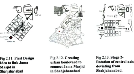
Fig 2.11. First Design Fig 2.12. Creating Fig 2.13. Stage
2-Idea to link Jama urban boulevard to Rotation of central axis,
Masjid in connect Jama Masjid deviating from
Shahjahanabad in Shahjahanabad Shahjahanabad. Source: Gupta, A. "Gupta, A. "Dominion Geometries", Masters in City
Planning (MCP) Thesis, MIT Cambridge, 2005.
While New Delhi was under evolution , the design ideas were influenced by several propositions made by theoreticians, historians, and architects all around
22 Gupta, A. " Dominion Geometries- Colonial Construction and Post Colonial Persistence
of Imperial in New Delhi Plan", Masters in City Planning (MCP) Thesis, MIT Cambridge, 2005.
the world. H.V Lanchester, a colleague of early humanist and planner Patrick
Geddes, proposed the first design, with the principal axis, which connected
Jamamasjid in Shahjahanabad to the governmental house, which sat on Malcha
Marg of Raisana hills. The idea was conceived on the lines of the Champs
Elysees in Paris. The view from governmental house to the largest mosque of the
country was the key idea behind the theme. Moreover , the plan incorporated a
commercial hub in the center of the boulevard, in the shape of a circle, which
later received the name Cannaught Place.
The second proposal retained the governmental house but introduced a cross
axial plaza with two secretariat blocks, to break the monotony of the long axis. In
the initial ideas of Lutyens plan, we can see how the planners and architects
responded to the historical monuments in Shahjahanabad, but later, due to
various monetary and infrastructure problems, the plan went under a series of
modifications and finally lost the monuments significance of many iconic
buildings in Shahjahanabad. Although, the plan was rotated and dimensions were
adjusted to physically suit the site, the major theme of imperialism remained the
same. For example, Paharganj area lying amidst the central axis of the planned
forum, housed 15,000 residents, who had to be relocated.
'u
Fig 2.14. Final design
with diagonal axis
connecting
Shahjahanabad
Source: Gupta, A. "Gupta, A.
Planning (MCP) Thesis, MIT
Fig 2.15. Final design
rig
I..with diagonal axis
Plan with
connecting Shahjahanabad
" Dominion Geometries", Masters in City
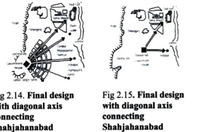
![Fig 5.32] Conservational development around the walls](https://thumb-eu.123doks.com/thumbv2/123doknet/14454001.519240/110.918.150.704.109.891/fig-conservational-development-walls.webp)
