Publisher’s version / Version de l'éditeur:
Vous avez des questions? Nous pouvons vous aider. Pour communiquer directement avec un auteur, consultez la première page de la revue dans laquelle son article a été publié afin de trouver ses coordonnées. Si vous n’arrivez pas à les repérer, communiquez avec nous à PublicationsArchive-ArchivesPublications@nrc-cnrc.gc.ca.
Questions? Contact the NRC Publications Archive team at
PublicationsArchive-ArchivesPublications@nrc-cnrc.gc.ca. If you wish to email the authors directly, please see the first page of the publication for their contact information.
https://publications-cnrc.canada.ca/fra/droits
L’accès à ce site Web et l’utilisation de son contenu sont assujettis aux conditions présentées dans le site LISEZ CES CONDITIONS ATTENTIVEMENT AVANT D’UTILISER CE SITE WEB.
Technical Memorandum (National Research Council of Canada. Division of
Building Research), 1953-12-10
READ THESE TERMS AND CONDITIONS CAREFULLY BEFORE USING THIS WEBSITE. https://nrc-publications.canada.ca/eng/copyright
NRC Publications Archive Record / Notice des Archives des publications du CNRC :
https://nrc-publications.canada.ca/eng/view/object/?id=f88a3f79-4617-47bd-a35a-d15ef73f75e5 https://publications-cnrc.canada.ca/fra/voir/objet/?id=f88a3f79-4617-47bd-a35a-d15ef73f75e5
NRC Publications Archive
Archives des publications du CNRC
This publication could be one of several versions: author’s original, accepted manuscript or the publisher’s version. / La version de cette publication peut être l’une des suivantes : la version prépublication de l’auteur, la version acceptée du manuscrit ou la version de l’éditeur.
Access and use of this website and the material on it are subject to the Terms and Conditions set forth at
Palaeobotanical method in the prediction of sub-surface Summer ice
conditions in Northern Organic Terrain
The Associate Committee on Soil and Snow }:echanics is one of 。「セ。エ thirty opecial 」ッセゥエエ・・ウ which assist the National Research Council in its work. Formed in 1945 to deal with an urgent wartime problem involving soil and snow, the Committee is now performing its intended task of co-ordinating Canadian resecrch studies concerned with the physical and mechanical properties of the terrain of the Dominion. It does this through subcommittees on Snow and
iセ・L Soil Mechanics, Muskeg, and Fermafrost. The Com-mittee, which consists of about fifteen Canadians ap-pointed as individuals and not a, representative" each
for a 3-year term, has funds available to it for making research grants for work in its fields of interest. In-quirie, will be welcomed and should be 。、、イ・ウウセ、 to: The Secretary, Associate Committee on Soil and Snow Mechanics, c/o The Division of Building Research, National Re3earch Council, Ottawa, Canada.
This ーオセャゥ」。エゥッョ i, one of a series being produced by the Associate Committee on Soil ard Snow Mechanics of the National Research Council. It may therefore be reproduced, without セ・ョ、ュ・ョエL provided that the Division is told in advance and that full and due acknowledgment of this publication is always made. No abridgment of this report may be published without the written authority of the Secretary of the aNcNsNsNセN Extracts may be published for purposes of review only.
NATIONAL RESEARCH COUNCIL
CANADA
ASSOCIATE COMMITTEE ON SOIL AND SNOW MECHANICS
Technical Memorandum No.
34
Palaeobotanical Method in the Prediction
of Sub-Surface Summer Ice Conditions
in Northern Organic Terrain
by
Norman W. Radforth
aイセaエ '{ZED
Reprint fran "Transactions of the Royal Society
of Canada", Volume XLVIII : Series III :
JUNE,1954-Section Five
Ottawa
TRANS.\CTIONS OF THE ROYAL SOCIETY OF CANADA
VOLUME XLVIII SERIES III : JUNE, 1954 SECTION FIVE
«<-«H<E«( «( «(«( «( «( «( «( «(«(«(«( «(.«+«<-«<-«(«(«( «(
«<-«H«-«<-«<-Palaeobotanical Method in the Prediction of Sub..Surface
Summer Ice Conditions in Northern Organic Terrain
By xormaセ W. RADFORTH Presented by G. KROTKOV, F.R.S.C.
p
e r セ l |f r o s t in Alaska and in the Canadian north is claiming increasing interest within the broader subject of terrain interpretation. It is prominent in the list of factors pertaining to northern development where agriculture, forestry, mining, and military planning are involved. Engineering construction and transportation are among many activities which because of permafrost must deal with circumstances not encountered in the south.The extensive organic terrain characterizing much of the north is physically one with the permafrost, the latter being as important a com-ponent of the organic terrain as water is of mineral soils in the south. Though it has not been emphasized in the literature, the influence of permafrost is probably due to the properties of its active layer for which the expression "climafrost"* is in use in our laboratory.
It is with the climafrost and its relationships to northern organic terrain that this paper deals. The main purpose is to bring to light the chief types of frost phenomena contributing to the physiography of the terrain, to investigate their character relative to variation in muskeg constitution, to ascertain whether their presence is predictable, and to explore their use-fulness as topographic agents in surface characterization of muskeg.
Examination of frost behaviour was made during the summer months in the region of Churchill, Manitoba, over a period of three years. Attempts to include in the study all characteristic types of organic terrain were encouraged.
In order to assist the reader in appreciating the results, reference should be made to work that preceded the frost studies. This is recorded elsewhere, and deals with the recognition of organization in organic terrain (1) and with the use of plant materials in predicting sub-surface change in its constitution (2). In both papers, vegetal coverage, the living component of the organic layer, was identified by combinations of class letters which described the coverage in terms of composite structural qualities rather than on the basis of plant names. Of the combinations of letters used, some were applied more frequently than others and were representative for most of the area geographically. A list of these coverage formulae is given in Table I, where their meanings in terms of vegetation structure are
*Suggested by W. 1- Thorne, Research Assistant, McMaster University, to designate that part of the permafrost affected by seasonal climatic factors.
52 THE ROYAL SOCIETY OF CANADA
TABLE I
SITES OF OCCURRENCE FOR SUB-SURFACE IcE PHENOMENA
Coverage formula HE FI EH invading BEH ABH,BHE ABE Structure
low, non-woody, of leathery texture, in mostly continuous mats, with low woody shrubs
non-woody, grass-like clumps or patches, sometimes touching, with non-woody, low velvety plants, often in continuous mats woody, low shrubs, with low, non-woody, stemless, leathery plants in mostly con-tinuous mats
woody, tree-forms, with low, non-woody, leathery plants in mostly continuous mats and low woody shrubs
woody, tree-forms of varying height (from 5 to 15 feet and over), with low, woody shrubs
- - - 1 - - - - _
also expressed. The coverage formulae mentioned in the table are those to which the significant information about ice-form applies. Because of their relationship to large areas of terrain, it will be clear that the character-istics of the ice will be widely applicable in the Churchill area.
SUB-SURFACE ICE FORMS
Discontinuous Forms
The retreat of winter conditions is followed by the occurrence of isolated and somewhat distinctive ice phenomena. These are of three main categories:
Type I. Vertical Free Lift (Fig. 1).
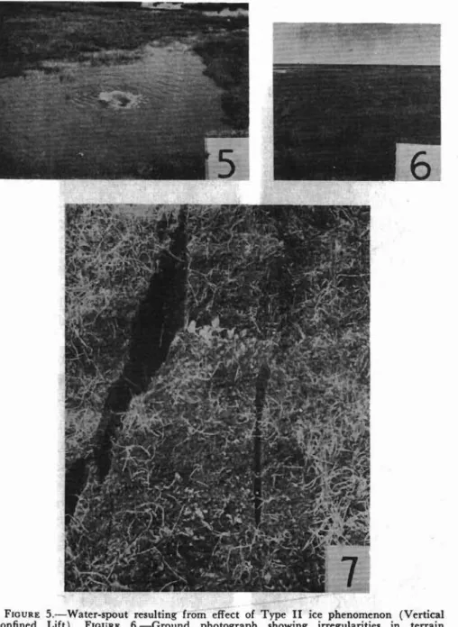
Type II. Vertical Confined Lift (Fig. 5).
Type III. Displacement Fault (Fig. 7).
Type I is characterized by localized heaving resulting in the upward thrust of irregular ice masses frequently exposed to view and capped by disrupted patches of the living and dead organic overburden.
Type II resembles Type I in that upward thrusting is involved. The evolution of the formation, however, differs. The effect of the vertical force is somewhat confined, with the partly frozen organic matter, depending upon its elasticity, gradually fonning a dome above the disturbance. The process takes two to three weeks and the amplitude of the dome is from two to three feet. Following this, the cohesiveness in the organic roof
z
o
セ
セ
セセ
..,
o
セ
,.-II
Nセ r..
.> a セ r ' , BG セL of,;" -; j[LBG[NセII
loa .... . ':41. . . ' " ...セNNNAゥ ojN
•. • '" Iセ NB ZBB セ
,セ セ
. _-
, ' - Jセ
. " ,_ . ' . f>rr "'\ t -l;" • " • - >". ' ... .... If! ,MG NB G セ
B G GH[セ [ セN G Nセセ N
,..•..
セLZZ
....•..セ
. . '.' ". <''': r' ,LG\ セ N イ セ セ
セ
セ L . . . '.n(' • .¥Lv , , -".;;-- ': " , '. . J f· ..セ .. , # •.
.
Lセセ LL ZN..-..
...
_.,.
.•
セ NG.
, G NセGN '.'
...
FIGURE I. -Ground photogr aph showing th e effect of Type I ice ph en om en on ( Vertica l Fr ee Lift). FIGURE 2.- Sit e typi cal for T yp e V ice ph enomen on ( Pond H ole ) an d in ba ckground site for T ype VIII ( M ult iple Knol1) . F IGUR E 3.-Aerial view sho wing effect of Type I V ice ph eno menon ( Polygon Di ffer ential ) . FIGUR E 4.- lr regula r terra in of exposed a nd hidd en bou lde rs, sit e for T ype VII ice ph enomenon ( Bo ulde r Lo cu s ).
VI
S4 THE ROYAL SOCIETY OF CANADA
FIGURE 5.-Water-spout resulting from effect of Type II ice phenomenon (Vertical Confined Lift). FIGURE 6.-Ground photograph showing irregularities in terrain (ridges) characteristic for Type VI ice phenomenon (Ridge Elevation). FIGURE 7.-Fissured terrain resulting from the effect of Type III ice phenomenon (Displacement Fault) .
normaセ W. RADFORTH 55
FIGURE 8.-Ground photograph showing change in topography at site of ice wedge in T>1>e IV (Polygon Differential ). FIGURE" 9.-Irregular terrain showing "mounding" condition often resulting from the effect of Type VI (Ridge Elevation }.
56 THE ROYAL SOCIETY OF CANADA
breaks down and a gush or water-spout issues forth. The water ejected maintains a steady stream rising about a foot in the air and subsides within a day or two. Flow may continue thereafter for an indefinite period depending upon local terrain conditions and water potential.
Type III arises as a result of action from lateral forces and results in
the splitting of the terrain followed by horizontal displacement. The crevasse so formed is usually not deep (20 to 26 inches) but the splitting may go deeper into the mineral substratum. On the surface, one crevasse was traced for about 75 feet, but many examples are shorter. Lateral dis-placement is usually not more than one foot at the widest point at ground level.
Whereas Type III affects terrain composure in the linear sense, I and
II disturb in terms of area so far as visual effects are concerned. The visible influence of the vertical free lift (Type I) is normally much more extensive than that of the vertical confined lift (Type II). The former may disrupt areas of as much as 10,000 sq. ft., whereas the latter disturbs usually not more than 25 sq. ft. Ultimately, however, slight subsidence in the area surrounding the ruptured dome may somewhat extend the area of physical deformity.
Each of the types mentioned represents a transient condition so far as terrain-contour change is concerned. By the third week in July in the vicinity of Churchill, visible detection of any of the types is difficult if not impossible.
Sites of occurrence for Types I and II are almost invariably found in
organic terrain designated by coverage formulae FI or occasionally J
(Table I). Type III, on the other hand, characterizes terrain supporting the BEH category of coverage (Table I).
Continuous Forms
Ice patterns of wider influence, which contribute more fundamentally to the physical character of the terrain in the summer, are not so readily recognized.
In the course of palaeovegetographical study (1, p. ) 2) sub-surface in-spection has revealed variation in contour of the c1imafrost as it recedes. Four main contour patterns are common.
Type IV, Polygon Differential (Figs. 3, 8).
This pattern, represented in section in the schematic diagram Fig. 10,
remains consistent in form until Septemher when its identity is partly loot
through melting. Until nearly the end of July its form persists no more than 20 inches below the surface of the organic matter and still high within it. Towards the end of August, it is still to be found within the organic matrix and in some cases persists up to the third week in September when frost conditions start the winter cycle at the surface. The wedges marking the margins of the ice polygons conform to the topographic character. (Fig. 8). The ice-surface plateau across the face of each ice polygon
there-NORMAN W. RADFORTH 57
HE
,.;---' \ Ice W.dqe
..
FIGURE IO.-The junction of two polygonal areas seen in sectional view, horizontal scale I" = 28", vertical scale I"= 8".
fore varies with the corresponding dimension measurable at the terrain surface. This distance may vary from 5 or 6 feet to about 50 feet. The ice at the wedges usually has less organic matter in it, is often aerated, and fractures very irregularly. That towards the centres of the polygons is normally impregnated with peat except for occasional ice lenses which vary in thickness from a few inches to a foot in depth. Until August the frozen peat is highly resistant to mechanical stress and repels the cutting edge of ordinary hand drills when attempts are made to drive them in with a sledge hammer.
It is hoped that this account of the ice features associated with the polygons will appropriately augment the account of polygon classification admirably devised by A. L. Washburn (3).
Type V, Pond Hole (Fig. 2).
This type, represented in section by Fig. 11, is also of frequent occur-rence. That part of the ice contour adjacent to open water recedes in depth faster than the remainder of the contour as the summer thaw advances. Thus high shoulders of ice may be found adjacent to ponds or drainage
reservoirs.
It will be noted in the composite diagram, Fig. 12, which is derived from actual measurement in the field, that the configuration is almost bilaterally symmetrical about a vertical axis running through the water.
58 THE ROYAL SOCIETY OF CANADA FI WATER J FI FI 1\ l - - - ; : : > { I I , /\ " 1\ / \ " GMMMMMMMMMMMMMMMMMMMMMMMセ_ャNL[ヲ| r; /\ \ - --( /\ A " 1\ /\ II II /\ II /\ II /\ 1\ {\/\II, II 1\ II, A II 1\ 1\ 1\ j\ {\ /\ /\ IIJ\ 1\ 1\ 1\ /\1\f\ f' /\/I f\ II II 1\ 1\ .1\ 1\ t- (\/\ 1\ /\ /\ FIGURE 1I.-Sectional view of ice contour change (lower line) for Type V (Pond
Hole, d. Fig. 12).
イセッst DEPTH CONTOUR IN INCHES VEGETATION BOUNDARY TRAVERSE LINE
NORMAN W. RADFORTH 59
Since reservoirs of this nature are of frequent occurrence and ice contour is characteristic for the physiographic condition, the contour pattern is correspondingly prevalent. Only the ratios of amplitudes of the peaks and depressions change with season; the basic pattern remains as a seasonal feature even though by mid-September the ice represented by the central part of the curve (Fig. 11) thaws to a level below the organic matter.
Type VI, Ridge Elevation (Fig. 6).
The ice contour line rising into the peaty shoulder in Fig. 11 eventually flattens out unless polygons are encountered or unless relatively poor drain-age conditions obtain. In the latter circumstances, the contour line will lower. In this kind of terrain, however (Fig. 6), ridges of different lengths are often in evidence topographically. Sometimes they form concentric arcs of very shallow curvature. If, on the other hand, the ridges are irregularly disposed, they are much broken and the segments are often so short that their length hardly exceeds their width, and a "mounding" condition exists (Fig. 9). Notwithstanding this, the ice contour is high in the sub-surface directly beneath the ridge; hence, the marked irregularity shown in the section (Fig. 13).
Ie
WATl:R
FIGURE 13.-Ice surface contour for Type VI (Ridge Elevation) seen in cross section.
Scale, horizontal and vertical 1"
=
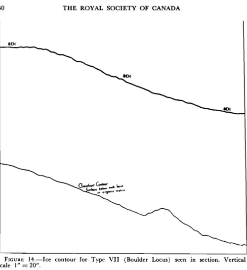
5.6'.Type VII, Boulder Locus (Fig. 4).
Where rock intrusions exist in the organic layer, depth of frost may be to some extent a function of the thickness and type of the organic over-burden characteristic of the area. It is more likely, however, that the ice contour is controlled by drainage conditions. The contour pattern shown in Fig. 14 is typical for frost-depth measurements on a traverse through a boulder site.
Type VIII, Multiple Knoll (Fig. 2, wooded background).
It is difficult to construct a type-configuration curve for this contour form. The reason lies in the presence of many combinations and
disposi-60
8EH
THE ROYAL SOCIETY OF CANADA
FIGURE 14.-Ice contour for Type VII (Boulder Locus) seen in section. Vertical scale 1"= 20".
tions of small and large knolls which constitute the elevated ice plateaus formed by the knolls. The top curvatures of the knolls differ in the length of their horizontal axes on an average of from one to four feet. Also, the extremities of their amplitudes come at different heights. These features are easily appreciated when an observer attempts to traverse the terrain either
in a vehicle or on foot. On the other hand, though the ice knolls can be
detected as they are passed over, they cannot always beseen. Often the
inter-knolls, so far as surface topography is concerned, are packed with growth which attains a height approaching that of the plants growing on the knolls, suggesting that the whole area in question is a level plateau with irregular sides.
In many cases, intermittent curves of horizontal, long tree-roots, and woody thickenings caused by two or more roots overlapping, form the nuclei for the knolls. Here, following the first week in August, knolls diminish in size rapidly though their presence can still be detected at the end of the same month.
NORMAN W. RADFORTH 61
CLIMAFROST RELATIONS WITH MACROFOSSIL CONSTITUTION OF THE ORGANIC TERRAIN
In the description of the multiple-knoll type of climafrost contour, there is suggestion of relationship between sub-surface vegetal parts and the ice contour pattern. It is frequently the case that the woody cores of the knolls are not root parts of present-day trees but preserved woody segments of trees of past generations. Indeed, such macrofossils characterize the areas where knolling effect prevails.
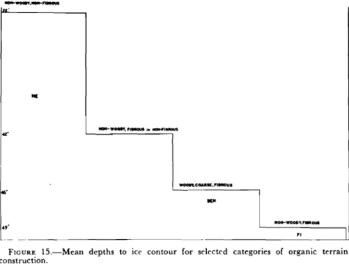
It has been demonstrated elsewhere, that the sub-surface constitution of the organic terrain varies widely depending upon size, form, frequency, and placement of the fossil components in the matrix (2). Because of this variation, frost depths were measured in all types of muskeg that com-monly constitute the terrain. Results of the analysis show that mean depths to frost line. for types of peaty coverage differed. Relationship among the means is expressed in the diagram Fig. 15: Further comparison between muskeg type and climafrost contour type is given in Table II (d. columns 2 and 4).
It should be emphasized that where structural constitution of the organic matter is uniform in depth and uninterrupted across the terrain, irregular-ity of ice-form contour is slight. It is equally important to stress, however, that the depth to the frost line will differ depending upon the macrofossil constitution of the muskeg type in question.
With seasonal shift, change in ice-form contour proceeds more rapidly I..' Me ... ....,.. 'I.-ou:ii.tDl4lUDUS oz-WOOO'r"CQUK.nawous fl6' IlM BセwoooBNBGoui 49'
"
I ..- -"FIGURE 1S.-Mean depths to ice contour for selected categories of organic terrain construction.
TABLE II
COVERAGE AND SUB-SURFACE ICE RELATIO/O;S
.:viuskeg identification Ice condition
0>
""
Coverage formulae HE FI EH invading BEH ABH, BHE, BEH j\BE 2 Sub-surface constitution (macroscopic) non-woody, "non-fibrous non-woody, fibrous woody, fine fibrous woody, coarse fibrouslarge roots and log rcmuanIs
:3
Special topographic feature where presen t
extensive peat plateaus
grouped nigger heads open or tilled in ponds
exposed or covered boulders occurring singly or in groups
moderately irregular often ridged
highly irregular 5 to 20 foot wide plateaus with wide clefts, f to :l feet deep
4 Contour pattern type Polygon Differential Vertical Free-Lift Vertical Confined Lift Pond Hole Boulder Locus Displacement Fault Ridge Elevation Multiple Knoll 5 Contour change rating low medium to high high high medium high high 6 Consistency of occurrence in related muskeg class
high medium to low high high low medium high セ ::x:: t'l セ
o
;;
r-rflo
o....
t'l セ 0<o
">:l o>
セ
t:J>
NORMAN W. RADFORTH 63
in some macrofossil assemblages than in others. A qualitative assessment of this circumstance is suggested in Table II, column 5. Comparative rates of change in depth corresponding to different macrofossil constitutions are expressed qualitatively in Table II, column 6. Though these designations are relative and empirical, they have been found to be useful in assessing and predicting seasonal dynamics in the climafrost.
VEGETAL COVERAGE IN RELATION TO CLIMAFROST
In the previous work (2), where the author established that coverage
classes of the living organic layer could be correlated with sub-surface con-stitution, no reference was made to ice formation. This matter has since been reviewed and the results of inquiry show that climafrost contours most
frequently relate to the types of coverage listed in Table I. These, in terms
of coverage formulae, are listed in Table II, column 1. Inspection of this table will suggest that corresponding ice-form contour types are character-istic for the coverage type in question. This is confirmed if a comparison of
coverage formulae and ice-form pattern contour is made in Figs. 10-14
inclusive.
It is useful to recognize that coverage class is often associated with
char-acteristic topographic features (Table II, columns 1 and 3). In
ascertain-ing or predictascertain-ing sub-surface ice conditions in the field, the utilization of this relationship is helpful.
It has been indicated elsewhere (1) that coverage formulae can be used validly for purposes of predicting sub-surface muskeg constitution, pro-vided limited laboratory microfossil inspection is supplied as collateral
information, It may also be inferred that the sub-surface organic terrain
conditions can be mapped since coverage distribution can be charted (1, pp. 6, 7). The author might have suggested this in a previous work but was prevented only because there was uncertainty then whether the
evi-dence contributed through analysis of the organic contents could be
re-lated to climafrost conditions. This difficulty is now obviated, and coverage formulae support the view that sub-surface ice phenomena can be pre-dicted and charted in terrain mapping and in interpreting aerial records.
ACKNOWLEDGMENTS
The work presented in this account relates to the interests of the Asso-ciate Committee on Soil and Snow Mechanics, National Research Council, and to the Arctic Research Section, Defence Research Board, National Defence Headquarters. Both organizations have provided material and financial assistance, and the author is grateful for this support. Colleagues and assistants have made their contributions in the field and in the labora-tory in procuring data utilized here. To these, the author is also indebted,
particularly to Miss Jean Evel, Mr. E.
J.
Johnson and Mr. W.J.
Thorne,pro-64 THE ROYAL SOCIETY OF CANADA
vided. Mr. R. F. Legget, Director, Division of Building Research and Chairman of the Associate Committee on Soil and Snow Mechanics, has inspired the author with his sustained interest and criticism as the muskeg investigations unfold.
REFERENCES
1. RADFORTH, N. W. (1952). Suggested classification of muskeg for the engineer. Engineering Jour. 35: 1-12.
2. - - - (1953). The use of plant material in the recognition of northern organic terrain conditions. Trans. Roy. Soc. Canada. Series III, 47, Sec. V: 53-71. 3. WASIIBURX, A. L. (1950). Patterned ground. Revue can. geog. 4: 5-54.
NATIIlNAL RESEARCH COllNCIL
ASSOCI A'T'l': COW'I'1'Tl'E ON SOIL AND SNQIl' MECHANICS LIST OF techセical VEMORANDA
1 Proposed ヲゥセャ、 soil testing devlce. August 1945.* Report classified "restricted". September 1945
rセーッイエ classified "confidential". November 1945
Soil survey of the Vehicle Proving Establishment, Ottawa. Oct. 1945.*
2
3
4
5 Method of measuring the significant characteristics of a snow-cover. G. J. Klein. Nov. 1946.
*
6 Repar tela ssified "canfident1ll1". November 1946 7 Report claasified "restricted". March 1947 8 Report classified "confidential". June 1947
a Proceedings of the 1947 Civilian SolI Mechanics Conference. Aug.1947 * 10 Proceedings of the Conference on Snow and Ice, 1947. Oct. 1947
11 Proceedings of the 1948 Civilian Soil Mechanics Conference. Oct.1949
*
12 Index to Proceedings of Rotterdam SoiL Mechanics Conference. May 1949 I) Canadian papers: Rotterdam sッセャ Mechanics Conference. June 1949 14 Canadian papers presented at the Oslo meetings of the InternetionalUnion of Geodesy and Geophysics. December 1949
IS Canadian survey of physical characteristics of snow-covers. G. J. Klein. April 1950
16 Progress report on organic terrain studies. N.W.Radforth. April 10SO
17 Proceedings of the 1949 Civilian Soil Mechanics Conference. Aug.1950 18 M3thod of measuring the aignificant characteristics of a snow-cover.
G. J. Klein, D. C. Pearce, L. W. Gold. November 1950
19 Proceedings of the 1950 Soil Mechanics Conference. April 1951 20 Snow studies in Germany. Major No. G. Bekker, Directorate of Vehicle
Development, Department of National Defence. May 1951
21 The Canadian snow survey, 1947-1950. D.C.Pearce,L.W.Gold. Aug. 1951 22 Annual report of the Canadian Section of the International Society of
Soil Mechanics and Foundation Engineering (June 1950 - June 1951) October 1951
2) Proceedings of the Fifth Canadian Soil Mechanics Conference, Jan. 10 and 11,1952. May 1952
(Continued on back of cover) * Out of print
LIST OF TECHNICAL MEMORANDA (Continued)
24 A suggested classification of muskeg for the engineer. N.W.Radforth. May 1952
Soil mechanics papere presented at the Building Research Congress
1951. November 1952 26 27 28 29 30 31 32 33
Annual report of the Canadian Section of the International Society of Soil Mechanics and Foundation Engineering (June 1951to
June 1952). December 1952
Proceedings of the Sixth Canadian Soil Mechanics Conference, Winnipeg, December 15 and 16, 1952. May1953
The use of plant material in the recognition of northern organic terrain characteristics. N. W. Radforth. March 1954
Construction and maintenance of roads over peat. F. E. Dryburgh and E. R. McKillop. (Reprinted with permission of D.S.I.R., Great Britain.) July 1954
Canadian papers presented at the Third International Conference on Soil Mechanics and Foundation Engineering. July 1954
The International Classification for Snow. (Issued by The Commiasion on Snow and Ice of the International Association of Hydrology.) August 1954
Annual Report of the Canadian Section of the International Society of Soil Mechanics and Foundation Engineering. June 1953to June 1954.
July 1954.
Proceedings of the Seventh Canadian Soil Mechanics Conference, Ottawa, December 10 and 11, 1953. September 1954.