HAL Id: halshs-01868028
https://halshs.archives-ouvertes.fr/halshs-01868028
Submitted on 4 Oct 2018HAL is a multi-disciplinary open access archive for the deposit and dissemination of sci-entific research documents, whether they are pub-lished or not. The documents may come from teaching and research institutions in France or abroad, or from public or private research centers.
L’archive ouverte pluridisciplinaire HAL, est destinée au dépôt et à la diffusion de documents scientifiques de niveau recherche, publiés ou non, émanant des établissements d’enseignement et de recherche français ou étrangers, des laboratoires publics ou privés.
Distributed under a Creative Commons Attribution - NonCommercial - NoDerivatives| 4.0 International License
An anthracological approach to understanding Late
Classic period cultural collapse in Mesoamerica’s
northwestern frontier
Michelle Elliott
To cite this version:
Michelle Elliott. An anthracological approach to understanding Late Classic period cultural col-lapse in Mesoamerica’s northwestern frontier. Ernestina Badal; Yoldanda Carrión; Miguel Macias; Maria Ntinou. Wood and Charcoal: Evidence for Human and Natural History, 13, Departament de Prehistòria i d’Arqueologia, Universitat de Valencia, pp.217-225, 2012, Saguntum Extra, 978-84-370-9062-7. �halshs-01868028�
a
n
anthraCologiCal
aPProaCh
to
undErstanding
l
atE
C
lassiC
PEriod
Cultural
CollaPsE
in
M
EsoaMEriCa
’
s
northWEstErn
frontiEr
UMR 8096 “Archéologies des Amériques”, CNRS. Maison René Ginouvès. 21, allée de l’Université. F-92023 Nanterre Cedex, France. Michelle.Elliott@mae.u-paris10.fr
Summary: For over 50 years, researchers have suggested that increased regional rainfall over the highland deserts of Mesoamerica’s
nor-thwestern frontier zone during the Classic period (AD 200-900) allowed for the colonization of the zone by farming groups who originated from Central and/or West Mexico. A severe and prolonged drought is hypothesized to have later provoked the abandonment of the region by these sedentary populations by AD 900. However, very little research has been carried out in the zone to detect evidence of this proposed climate change. I present results from the first systematic study of wood charcoal from the northwestern frontier, comparing the data from three Classic period ceremonial centers that span the region’s north-south gradient of intensifying aridity. The results indicate that the stron-gest evidence of environmental degradation is found in the south (where average annual rainfall is the highest), while the sites located farther north (with lower annual rainfall) demonstrate more stable use of wood resources. These findings suggest that anthropogenic impact played a more significant role in regional abandonment than climate change, and that the current models of the process of the collapse in the nor-thwestern frontier may need to be reconsidered.
Key words: Mesoamerica, anthracology, wood charcoal, forest management, human impact.
INTRODUCTION
Scholars have proposed that the development and later collapse of sedentary agricultural societies in the northwestern frontier of Mesoamerica was driven by regional climate change (Palerm and Wolf 1957; Armillas 1964, 1969). The occupation of the zone spanned the Classic period (AD 250-900), with the peak of population growth focused in the period AD 600-800 (Fig. 1).
This period of demographic growth is hypoth-esized to be characterized by a significant increase in annual precipitation caused by a rise in global sea
sur-face temperatures (culminating in the Medieval Warm Period) and the northward shift of subtropical high pressure zones in the northern hemisphere (Armillas 1964: 77-79; Gunn and Adams 1981: 96). This climate change expanded fertile grassland zones and reduced the semi-arid steppe in the frontier region, enticing Mesoamerican farmers from Central and West Mexico to settle farther north. Later, a decrease in global tem-peratures (linked to the Little Ice Age) led to drought conditions over northern Mexico and provoked the ex-pansion of semi-arid steppe, poorly adapted to maize farming, toward the south. After a regional collapse around AD 900, the area did not see large-scale
seden-MiChEllE Elliott
WOOD AND CHARCOAL. EVIDENCE FOR HUMAN AND NATURAL HISTORY. SAGVNTVM EXTRA-13, 2012.
218
led contexts at frontier sites (Trombold 1990; Nelson 1997; Lelgemann 2000). These dates indicate the sites were primarily founded around AD 500 and that they were abandoned at the latest by AD 900. Earlier gen-erations of archaeologists had believed that the fron-tier settlements were founded closer to AD 600 and were not abandoned until at least AD 1200. The more accurate dating suddenly pushed the sequence of set-tlement and abandonment of the northwestern frontier zone back before either of the global climate changes that had been proposed as triggering factors (Fig. 2).
Furthermore, the lack of systematic paleoenviron-mental studies carried out in the northwestern fron-tier zone itself makes it difficult to assess how global climate changes manifested at the regional scale, and also how human land-use strategies and responses to climate factors affected local landscape evolution. In fact, the few studies that have been carried out in the region do not support the idea of environmental stress provoking social collapse. Instead, they indicate that the Classic and Postclassic periods were climatically stable, and that the greatest disturbance to the envi-ronment (producing the landscapes that are visible to-day) are the product of Colonial and Historic land-use practices that began in the 16th century (Brown 1992;
Frederick 1995; Trombold and Isarde-Alcántara 2005; Elliott et al. 2010).
Thus, some important questions that remain unan-swered are 1) did the environment of the frontier zone change through time? 2) How spatially homogenous were these changes? and 3) does the occurrence and the pace of environmental change correlate with cul-tural changes in the Classic period settlements? To be-gin to address these questions, I present the first study of wood charcoal for the region, focusing on three Classic period archaeological settlements that span the north-south axis of the frontier zone.
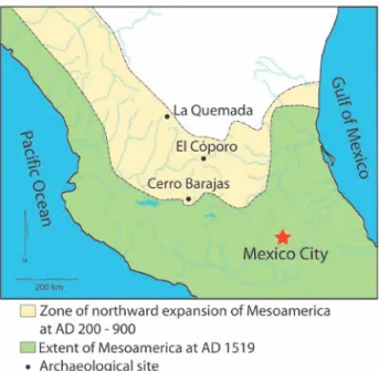
BACKGROUND AND ENVIRONMENT
The Mesoamerican northwestern frontier zone is an expanse of roughly 100,000 km2 whose southern
tary settlements again until the arrival of the Spanish in the early 1500’s.
Despite the apparent logic to this model of linked climatic and cultural change, later research demon-strated a number of difficulties. One principal problem lay in the chronology of events. It has only been since the 1990’s that systematic programs of radiocarbon dating have been carried out on multiple,
well-control-Figure 1. Map of the northern frontier zone of Mesoamerica with the locations of archaeological sites discussed.
Figure 2. Chronology of the occupation of the Mesoamerican north-western frontier compared with global climate changes.
EL CÓPORO
El Cóporo is located in the Ocampo Valley of Gua-najuato, approximately 120 km northeast of Cerro Barajas, in the foothills of the Sierra Santa Barbara, at 2200 m a.s.l. (Torreblanca Padilla 2007). This monu-mental center is fairly isolated, being much larger than other contemporary sites in the valley, which are villages and hamlets. The valley’s vegetation is char-acterized by cacti, yucca, mesquite, acacia, and other leguminous trees and shrubs. The average annual rain-fall is 485 mm. The Sierra Santa Barbara, which rises to an elevation of 2650 m a.s.l. to the east, is marked by pine, oak, and madroño (Arbutus xalapensis).
The archaeological site consists of several com-plexes of domestic and ceremonial architecture lo-cated on the valley floor, as well as in hilltop posi-tions that mark the interface of the mountains and the Ocampo valley. The Gotas complex, on the valley floor, contains a monumental hall of columns similar to that of Los Nogales at Cerro Barajas and the cere-monial precinct at La Quemada (see below). The peak of occupation occurred between AD 600 and 800, and the site was unoccupied by AD 1000.
LA QUEMADA
La Quemada is the northernmost site. It is located in the Malpaso Valley of southern Zacatecas, 250 km northwest of Cerro Barajas and 180 km northwest of El Cóporo. La Quemada is larger than the other con-temporaneous sites in the valley by several orders of magnitude, and like El Cóporo, represents an isolated ceremonial center. The floor of the Malpaso Valley is 1950 m asl and sits in the foothills of the Sierra Madre Occidental. It has an average annual rainfall of 400 mm and is marked by nopal cactus, yucca, acacia, and some mesquite. Although Colonial period documents attest to the presence of pine and oak in the valley, none are observed today. The closest existing pine-oak forest is in the Sierra Fría, approximately 25 km to the southeast. Studies of the settlement pattern formed boundary follows the course of the Río
Lerma-San-tiago. Annual precipitation averages 700-800 mm along the southern margin, which is characterized by grassland and sub-tropical forested patches in low lying areas, transitioning into pine and oak forest in mountainous zones (Armillas 1964: 63; Labat 1995). This southern edge also marks the modern limit for non-irrigated maize agriculture, and it was an area of cultural division in the 16th century, with groups of
sedentary farmers to the south and mobile societies in the arid north (Armillas 1964: 65). As one moves northwest toward the Sierra Madre Occidental, rain-fall decreases to 450 mm annually, and the landscape transitions to semi-arid steppe and desert vegetation (e.g., cactus, acacia, mesquite).
CERRO BARAJAS
Cerro Barajas is the southernmost of the three communities presented in this study. It is located in southwest Guanajuato in the Bajío region, a lowland zone of valleys, plains, and rolling hills between 1600 and 1800 m a.s.l. that surround the course of the Río Lerma-Santiago. The Bajío is one of the most important agricultural centers of modern Mexico. Uncultivated areas of the zone are marked by acacia and cacti. The region was fairly densely settled in the Classic period, with several other similarly sized ceremonial centers (e.g., Peralta, Plazuelas, Zarago-za) located within a few kilometers of Cerro Bara-jas (Fernández Villanueva 2004; Cárdenas 2007; Castañeda 2007).
Cerro Barajas is a volcanic massif located just north of the Río Lerma and characterized by more than 20 prehispanic settlements that date to the Epi-classic period (Pereira et al. 2005). Los Nogales is the largest and most monumental of the ceremonial centers on the massif. All of the sites were abandoned by AD 900, following a phase in which fortifications were added to many of the larger sites. Nevertheless, there is no evidence of violence or warfare associ-ated with the abandonment of Cerro Barajas.
MiChEllE Elliott
WOOD AND CHARCOAL. EVIDENCE FOR HUMAN AND NATURAL HISTORY. SAGVNTVM EXTRA-13, 2012.
220
and vouchered by the Herbarium of the Universidad Nacional Autonoma de México. Botanical survey and mapping was also carried out at Cerro Barajas to iden-tify communities of trees and shrubs and their asso-ciations with altitude and land-use (Elliott in prepara-tion), complementing earlier work in the Bajío region by Labat (1995).
DATA AND RESULTS
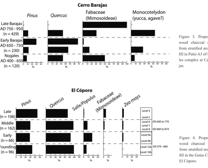
891 pieces of wood were analyzed from 11 flota-tion samples excavated from the patio of a monumen-tal elite residence at the site of Los Nogales (Fig. 3). The sediment excavated comes from stratified trash deposits used as architectural fill over the course of the patio’s construction and various remodeling episodes. Wood is present from a pine-oak zone and secondary, disturbed woodland. Fabaceae is present in all sam-ples while pine and oak are present in eight of the 11 samples. By counts, pine-oak and disturbed woodland zones are present in the assemblage almost equally (34% pine-oak, 30% Fabaceae). A high percentage of monocotyledon remains were also recovered (27% by the more than 250 contemporaneous village and
hamlet sites in the valley indicate access to rivers and seasonal streams was of paramount importance (El-liott 2005).
La Quemada was the valley’s principal prehis-panic ceremonial center, covering 50 ha. It consists of more than 50 terraces constructed atop a small moun-tain (Nelson 1995). The ceremonial precinct conmoun-tains a hall of columns that is one of the largest in Mes-oamerica. The site was founded by AD 550 and the peak of occupation occurred between AD 600 and 800 (Nelson 1997). The site was no longer permanently occupied by AD 900.
METHODS
Ten-liter sediment samples were collected system-atically from every excavation level of three stratified midden deposits (La Quemada) or stratified trash de-posits used as fill in monumental architecture (Cerro Barajas and El Cóporo). Samples at La Quemada and El Cóporo were floted using a combination of manual and machine assisted techniques. Samples at Cerro Barajas were floted manually.
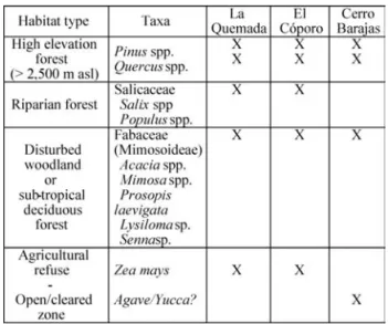
The taxa recovered in the archaeological samples are listed in Table 1, along with the assumed habitat type that they represent.
The Fabaceae genera that occur around the sites today are typically associated with “sub-tropical de-ciduous forest”. While this woodland type is often presented as a natural vegetation community, the pre-vailing opinion among botanists in the region is that it is in fact the result of anthropogenic degradation of primary forest (Labat 1995). It was difficult to distin-guish between Salix and Populus, thus no distinction is made between these two riparian genera.
In total, 1,792 fragments of wood charcoal were identified using a reflected light binocular micro-scope at magnifications of 100x – 400x. Charred wood references and published photographs of wood anatomy were used in the identifications. The mod-ern wood samples were collected at Cerro Barajas
Table 1. A list of the wood charcoal taxa recovered in the archaeo-logical samples and the assumed habitat type each is interpreted to represent. Their presence at each site is noted in the corresponding column with an “X”. The Fabaceae charcoal recovered belongs to the Mimosoideae sub-family, but for the moment it is not possible to make more precise identifications.
monumental Hall of Columns in the Gotas Complex at El Cóporo (Fig. 4). The fill for this patio was deposited over time and came from various trash deposits, pre-senting a well-stratified pattern that is confirmed by radiocarbon dating. Wood resources are present from pine-oak forest, riparian, and open grassland/desert zones that may have included cultivated fields. The taxa observed include Pinus, Quercus, Salix/Populus, Fabaceae, and Zea mays. Pine and oak are present in all samples, while Fabaceae is present in only two. The pine-oak forest also dominates the assemblage in counts (74%). This finding is notable because there is no pine or oak visible around the site currently, indi-cating that either the site’s inhabitants traveled long distances to obtain this wood, or that significant land-scape change has occurred since the site’s abandon-ment. Fabaceae shrubs and small trees dominate the modern landscape.
of the total assemblage). These consist of many large fragments that indicate a plant with flat, broad leaves, such as yucca or agave. These remains are predomi-nantly found in levels that are associated with burning of the structure, and likely represent material used to construct the roof.
Those samples that can be assigned to early, mid-dle, and late phases of construction (Nogales, Early Barajas, and Late Barajas) indicate important changes in the use of wood. A sudden decrease in pine and oak is correlated with a strong increase of Fabaceae in the late phase, which suggests over-exploitation of the lo-cal forest and subsequent colonization by woody taxa that thrive in disturbed environments. This pattern co-incides with the period of peak population growth and construction at Cerro Barajas.
520 pieces of wood were analyzed from eight flo-tation samples excavated from the interior patio of the
Figure 3. Proportions of wood charcoal recovered from stratified architectural fill in Patio A3 of the Noga-les complex at Cerro Bara-jas.
Figure 4. Proportions of wood charcoal recovered from stratified architectural fill in the Gotas Complex at El Cóporo.
MiChEllE Elliott
WOOD AND CHARCOAL. EVIDENCE FOR HUMAN AND NATURAL HISTORY. SAGVNTVM EXTRA-13, 2012.
222
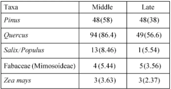
the period AD 550-800. The overall pattern indicates stable patterns of wood use, until the late period, when pine, oak, and riparian taxa decrease, and a slight in-crease in Fabaceae is detected. A chi-square test indi-cates these changes occur at a statistically significant level (Table 2). Nevertheless, these changes are more subtle than those observed at Cerro Barajas.
381 pieces of wood from 50 flotation samples were analyzed from three well-stratified and radiocarbon dated middens at La Quemada (Fig. 5). The results indicate that the inhabitants of the site had access to trees from a variety of ecological settings that include pine-oak forest, a riparian zone, and open areas that appear to have included agricultural fields. The taxa recovered include Pinus, Quercus, Salix/Populus, Fa-baceae, and Zea mays.
At La Quemada, riparian and pine-oak forests are the most significant sources of wood used. There are no significant changes through time in the proportions of wood used from the pine-oak, riparian, and open/ agricultural zones.
A correspondance analysis of the charcoal data from all three sites more clearly illustrates the simi-larities between the two northern sites (La Quemada and El Cóporo), and their distinction from the more southern site (Cerro Barajas) (Fig. 6). Riparian taxa are most closely associated with La Quemada, and high-elevation pine-oak forest is clearly associated with El Cóporo. In contrast, Cerro Barajas is most closely related to monocotyledons and Fabaceae, taxa that tend to be linked to semi-arid conditions and/or anthropogenic disturbance of soils.
DISCUSSION AND CONCLUSIONS
The results indicate that the environment of each of the three archaeological zones has changed signifi-cantly at some point subsequent to the Late Classic period. The higher elevation pine-oak forests have contracted and forested patches that are well adapted to dry and/or disturbed conditions have increased. However, these changes are not uniform through time The levels of the Hall of Columns can be divided
into founding, early, middle, and late phases that span
Figure 5. Proportions of wood charcoal recovered from three strati-fied middens at La Quemada.
Figure 6. Correspondence analysis of wood taxa recovered at all sites. Taxa associated with anthropogenic disturbance and/or dry climatic conditions (in brown) cluster with Cerro Barajas, while high altitude forest and riparian vegetation (in green) are more clo-sely associated with La Quemada and El Cóporo.
Table 2. A chi-square test of changes in wood taxa frequencies bet-ween the Middle and Late period at El Cóporo. Observed frequen-cies are listed first, and expected frequenfrequen-cies are in parentheses. Χ2 = 13.4, df = 4, p = 0.009.
detected. Although each of these northwestern fron-tier communities were situated in ecologically frag-ile zones, the southern settlement with higher annual rainfall (Barajas) may have appeared more abundant in wood resources, thus attracting a higher density of people and the founding of large centers with intense wood resource needs (demonstrated by the regional settlement pattern), resulting in greater anthropogenic impact in the long-term. In contrast, drier (and more unpredictable?) climate conditions farther north at El Cóporo and La Quemada may have made these popu-lations more cognizant of the necessity for the man-agement of wood resources, and coupled with a lower settlement density, resulted in a more stable pattern of resource use over the long-term. A similar pattern has been documented between the Mimbres Valley of western New Mexico and the more arid Eastern Mim-bres zone (Hegmon et al. 2006).
If the observed contrasts in wood use strategies and settlement density are indeed products of differ-ing environmental conditions, it still remains to be explained why these frontier centers (and others like them across the region) all collapsed at essentially the same moment in time, despite some successfully developing sustainable strategies of resource manage-ment. The findings presented here indicate that the factors surrounding the regional collapse are complex and merit a more detailed explanation than simple environmental change. The social, economic, and po-litical connections among these sites deserve further investigation (as well as the addition of data from other contemporary sites) to better understand how their developmental trajectories affected one another and what the long-term consequences of their interac-tions were at the regional scale. In addition, off-site paleoenvironmental reconstructions, focused on a variety of environmental proxies, should be carried out near multiple Classic period centers in the north-western frontier (such as Elliott et al.’s 2010 analy-sis near La Quemada). These studies would provide a complement to the charcoal studies and improve our understanding of the accuracy of anthracological data or space. They are likely the result of anthropogenic
impacts, which in some cases began in the Prepanic period, and later intensified in the Colonial, his-toric, and modern periods. The evidence for stress in wood resources at Cerro Barajas and El Cóporo cor-relates with the later phase of occupation (the period of most intense demographic growth). In contrast, La Quemada exhibits a stable pattern of wood use that is independently supported by data from Elliott et al.’s (2010) study of alluvial sediments in the same valley, which indicates that little climatic change has occurred over the last 2000 years, but that significant landscape degradation followed the introduction of mining and livestock by the Spanish in the 16th century.
The evidence for landscape change across the frontier zone is negatively correlated with the degree of aridity. The strongest evidence for wood resource stress comes from Cerro Barajas, the zone with the highest annual rainfall. La Quemada shows long-term stability, despite its significantly lower annual precipi-tation. El Cóporo appears to follow a more interme-diary pattern, with some evidence of wood resource stress, but much less marked than that for Cerro Bara-jas.
I suggest that a possible explanation for this pat-tern is stronger demographic pressure on resources at the more southerly sites toward the end of the Clas-sic period. Cerro Barajas is comparable in scale to La Quemada and El Cóporo, but the density of large centers overall is much higher in the Bajío region than it is in the northern reaches of the frontier zone. Cerro Barajas coexisted within a few kilometers with a number of neighboring monumental Classic period centers. In contrast, in the more semi-arid north, large centers such as El Cóporo and La Quemada are isolat-ed, resulting in much lower settlement densities, and lower resource demands.
However, I would argue that the differences ob-served in the wood charcoal assemblages are not due simply to population pressure alone. I propose that contrasting perceptions of the availability of wood resources also contributed to the divergent patterns
MiChEllE Elliott
WOOD AND CHARCOAL. EVIDENCE FOR HUMAN AND NATURAL HISTORY. SAGVNTVM EXTRA-13, 2012.
224
lization. Transactions of the New York Academy of
Sciences, Series II 31, 697-704.
BROWN, R.B. (1992): Arqueología y Paleoecología del
Norcentro de México. Mexico City, Insituto
Nacio-nal de Antropología e Historia.
CARDENAS, E. (2007): Peralta, el reconto delos gobernan-tes. In: Zonas arqueológicas en Guanajuato. Cuatro
casos: Plazuelas, Cañada de la Virgen Peralta y El Cóporo, 21-70.
CASTAÑEDA, C. (2007): Plazuelas, Pénjamo. In: Zonas
arqueológicas en Guanajuato. Cuatro casos: Pla-zuelas, Cañada de la Virgen Peralta y El Cóporo,
Mexico.
ELLIOTT, M. (2005): Evaluating evidence for warfare and environmental stress in settlement pattern data from the Malpaso Valley, Zacatecas, Mexico. Journal of
Anthropological Archaeology 24, 297-315.
ELLIOTT, M. (in preparation): Classic period wood re-source use and landscape change at Cerro Barajas (Guanajuato, Mexico).
ELLIOTT, M.; FISHER, C.T.; NELSON, B.A.; MOLINA GARZA, R.S.; COLLINS, S.K.; PEARSALL, D.M. (2010): Climate, agriculture, and cycles of human occupation over the last 4,000 years in southern Za-catecas, Mexico. Quaternary Research 74, 26-35. FERNADEZ VILLANUEVA, E. (2004): Evidencias de una
tradición mesoamericana en Zaragoza. In: E. Cárde-nas, ed. Tradiciones arqueológicas en el occidente
de México, 291-206. El Colegio de Michoacán,
Za-mora.
FREDERICK, C.D. (1995): Fluvial Response to Late
Qua-ternary Climate Change and Land Use in Central Mexico. Unpublished doctoral thesis, University of
Texas, Austin.
GUNN, J.; ADAMS, R.E.W. (1981): Climate Change, Cul-ture, and Civilization in North America. World
Ar-chaeology 13, 87-100.
HEGMON, M.; NELSON, M.C.; GUST SCHOLLMEYER, K.; ELLIOTT, M.; DIEHL, M.W. (2006): Agricul-ture, Mobility, and Human Impact in the Mimbres Region of the United States Southwest. In: J. L. Hantman, R. Most eds. Managing archaeological
to reflect episodes of landscape change or stability across a region where this method has not previously been applied.
What can be concluded for the moment from the charcoal data is that models of frontier abandonment that assume climate change was the primary cause and that a process of collapse originated on the north edge of the frontier and then spread to the south may re-quire revision. Instead, they raise the possibility that cultural collapse originated in the southern edge of the frontier due to anthropogenic degradation and then spread to sites farther north. The collapse of large sites like Cerro Barajas, which sit along major corridors for the movement of people, goods, and ideas, between Central and West Mexico and regions farther north, would likely have severed key lines of communication with the Mesoamerican core for communities such as El Cóporo and La Quemada. This process might therefore be more accurately visualized as a cultural “implosion” that began in the south and whose socio-political-economic “shockwaves” traveled quickly northward.
ACKNOWLEDGEMENTS
This study was financed by a Fyssen Foundation post-doc-toral research grant and the UMR 8096 “Archéologies des Amériques” (CNRS and University of Paris 1). I wish to thank Ben Nelson, Carlos Torreblanca, Grégory Pereira, Stéphanie Thiebault, and the Consejo de Arqueología of the Instituto Nacional de Antropología e Historia de México for their support.
REFERENCES
ARMILLAS, P. (1964): Condiciones Ambientales y Mo-vimientos de Pueblos en la Frontera Septentrional de Mesoamérica. Homenaje a Fernando
Márquez-Miranda. Publicaciones del Seminario de Estudios
Americanistas y Seminario de Antropología Ameri-cana, Universidades de Madrid y Sevilla.
Civi-PEREIRA, G.; MIGEON, G.; MICHELET, D. (2005): Transformaciones Demográficas y Culturales en el Centro-Norte de México en Vísperas del Posclásico: Los Sitios del Cerro Barajas (Suroeste de Guanaju-ato). In: L. Manzanilla ed. Reacomodos
Demográfi-cos del Clásico al Pósclasico en el Centro de Méxi-co. (Mexico City, UNAM, Instituto de
Investigacio-nes Antropológicas.).
TORREBLANCA PADILLA, C.A. (2007): El Cóporo, Ocampo: La arquéologia del Tunal Grande. Zonas
arqueológicas en Guanajuato. Guanajuato, Mexico,
Instituto Estatal de la Cultura.
TROMBOLD, C.D.; ISRADE-ALCANTARA, I. (2005): Paleoenvironment and Plant Cultivation on Terraces at La Quemada, Zacatecas, Mexico: The Pollen, Phytolith and Diatom Evidence. Journal of
Archae-ological Science 32, 341-353.
TROMBOLD, C.D. (1990): A Reconsideration of Chronolo-gy for the La Quemada Portion of the Northern Meso-american Frontier. American Antiquity 55, 308-323.
data: essays in honor of Sylvia W. Gaynes. Arizona
State University Anthropological Research Paper, 107-121.
LABAT, J.-N. (1995): Végétation du Nord-Ouest du
Mi-choacán Mexique. Instituto de Ecología, Xalapa,
Veracruz.
LELGEMANN, A. (2000): Proyecto Ciudadela de La
Que-mada, Zacatecas. Report on file with the Instituto
Nacional de Antropología e Historia, Mexico City. NELSON, B.A. (1995): Complexity, Hierarchy, and Scale:
A Controlled Comparison between Chaco Canyon, New Mexico, and La Quemada, Zacatecas.
Ameri-can Antiquity 60, 597-618.
NELSON, B.A. (1997): Chronology and Stratigraphy at La Quemada, Zacatecas, Mexico. The Journal of Field
Archaeology, 24, 85-109.
PALERM, A.; WOLF, E.R. (1957): Ecological Potential and Cultural Development in Mesoamerica.
Stud-ies in Human Ecology: A SerStud-ies of Lectures Given at the Anthropological Society of Washington, 1-37.
![[PDF] Formation Excel Initiation | Télécharger PDF](data:image/gif;base64,R0lGODlhAQABAIAAAP///wAAACH5BAEAAAAALAAAAAABAAEAAAICRAEAOw==)