HAL Id: hal-03089459
https://hal-cnrs.archives-ouvertes.fr/hal-03089459
Submitted on 28 Dec 2020
HAL is a multi-disciplinary open access
archive for the deposit and dissemination of
sci-entific research documents, whether they are
pub-lished or not. The documents may come from
teaching and research institutions in France or
abroad, or from public or private research centers.
L’archive ouverte pluridisciplinaire HAL, est
destinée au dépôt et à la diffusion de documents
scientifiques de niveau recherche, publiés ou non,
émanant des établissements d’enseignement et de
recherche français ou étrangers, des laboratoires
publics ou privés.
Cave dripwater isotopic signals related to the altitudinal
gradient of Mount-Lebanon: implication for speleothem
studies
Carole Nehme, Sophie Verheyden, Fadi Nader, Jocelyne Adjizian-Gerard,
Dominique Genty, Kevin de Bondt, Benedicte Minster, Ghada Salem, David
Verstraeten, Philippe Claeys
To cite this version:
Carole Nehme, Sophie Verheyden, Fadi Nader, Jocelyne Adjizian-Gerard, Dominique Genty, et al..
Cave dripwater isotopic signals related to the altitudinal gradient of Mount-Lebanon: implication for
speleothem studies. International Journal of Speleology, Società Speleologica Italiana, 2019, 48, pp.63
- 74. �10.5038/1827-806x.48.1.2253�. �hal-03089459�
Available online at scholarcommons.usf.edu/ijs
International Journal of Speleology
Off icial Journal of Union Internationale de SpéléologieCitation: Keywords:
Abstract: An important step in paleoclimate reconstructions based on vadose cave carbonate deposits or speleothems is to evaluate the sensitivity of the cave environment and speleothems to regional climate. Accordingly, we studied four caves, located at different altitudes along the western flank of Mount-Lebanon (Eastern Mediterranean). The objectives of this study are to identify the present-day variability in temperature, pCO2, and water isotopic composition and to assess the possible influence of the altitudinal gradient on cave drip waters and cave streams. We present here an overview of the spatial variability of rainwater based on local and regional data, and we compare these data with our results, i.e., temperature, air pCO2, and the isotopic composition of cave water and modern cave calcite collected in 2011 and 2014. The results show that the rainwater isotopic signal is generally preserved in the cave dripwater isotopic composition with some exceptions in large caves with high ceilings where evaporation effects may influence its isotopic composition. The altitude effect observed in rainwater isotopic composition seems to be transferred to the cave dripwater. Different δ18O/100 m gradients between dripwater and rainwater (0.13‰ and 0.21‰, respectively) are noted. This is mainly attributed to the δ18O/100 m value of the dripwater which is site-specific and dependent on i) local processes within the epikarst/soil, ii) the relation to the precipitation altitude gradient and iii) the extension of the defined infiltration basin.
drip water, isotopic signal, Lebanon, caves, altitude gradient
Received 8 February 2019; Revised 26 February 2019; Accepted 26 February 2019
Nehme C., Verheyden S., Nader F.B., Adjizian-Gerard J., Genty D., De Bondt K., Minster B., Salem G., Verstraeten D. and Claeys P., 2019. Cave dripwater isotopic signals related to the altitudinal gradient of Mount-Lebanon: implication for speleothem studies. International Journal of Speleology, 48 (1), 63-74. Tampa, FL (USA) ISSN 0392-6672
https://doi.org/10.5038/1827-806X.48.1.2253
Cave dripwater isotopic signals related to the altitudinal gradient
of Mount-Lebanon: implication for speleothem studies
Carole Nehme
1,2,3*, Sophie Verheyden
2,4, Fadi H. Nader
5, Jocelyne Adjizian-Gerard
6,
Dominique Genty
7, Kevin De Bondt
2, Benedicte Minster
7, Ghada Salem
3, David
Verstraeten
2, and Philippe Claeys
21Laboratoire IDEES UMR 6266 CNRS, University of Rouen Normandy, rue Thomas becket, 76821, Mont-Saint Aignan Cedex, France
2Analytical, Environmental & Geo-Chemistry, Department of Chemistry, Vrije Universiteit Brussel, Pleinlaan 2, 1050 Elsene, Brussels, Belgium 3ALES, Association Libanaise d'Etudes Speleologiques, Mansourieh El-Matn, Lebanon
4Directorate of Earth and Quaternary, Royal Belgian Institute of Natural Sciences (RBINS), rue Vautier 29, 1000, Brussels, Belgium 5Energie France Pétrole-Nouvelles, 4, avenue de Bois-Préau, 92852, Rueil-Malmaison Cedex, France
6CREEMO, Saint-Joseph University of Beirut, Faculty of Human Sciences, Rue de Damas, BP 17-5208, Beirut, Lebanon
7Laboratoire des Sciences du Climat et de l’Environnement (LSCE/IPSL), UMR 8212 CEA/CNRS/UVSQ, F-91191, Gif sur Yvette Cedex, France
INTRODUCTION
Speleothems, which are secondary cave carbonate deposits that precipitate from cave drip water are increasingly used to reconstruct changes in regional climate and vegetation. Their isotopic composition, δ18O, and δ13C is influenced mainly by respectively the
isotope signature of rainwater linked to temperature (Clarck & Fritz, 1997; Lachniet, 2009) and by the carbon isotopic composition of dissolved carbon influenced by the soil bioactivity (δ13C), linked to
vegetation and thus to temperature and water availability (Hellstrom et al., 1998; Genty et al., 2006).
Rainwater and dissolved carbon circulate through the unsaturated zone, i.e. the upper part of the epikarst, which is affected by dissolution and is characterized by a mainly vertical transfer of percolation water to the cave (Hendy, 1971; Bar-Matthews et al., 1996; Ford & Williams, 2007; Fairchild & Baker, 2012).
Several cave monitoring programs have been conducted worldwide, providing information on the role of local cave environment and hydrology that possibly influence stalagmite-based palaeoclimate proxy records (Bar-Matthews et al., 1996; Spotl et al., 2005; Baldini et al., 2006; Verheyden et al., 2008a; Mattey et al., 2010; Miorandi et al., 2010; Tremaine
et al., 2011; Johnston et al., 2013; Genty et al., 2014; Deininger et al., 2014; Van Rampelbergh et al., 2014; Suric et al., 2016; Beddows et al., 2016). These studies aim at understanding better the registration of the nowadays climatic signal in speleothems in order to more precisely constrain the past climatic records.
In the Levant region, although speleothems from Palestine/Israel are well studied and proxy interpretations well-supported by monitoring programs, the rest of the region is still understudied in terms of speleothem-based paleoclimate studies (Nader et al., 2007, Verheyden et al., 2008b, Cheng et al., 2015, Nehme et al., 2015; 2018). Nearly no cave monitoring information is available and only limited rainwater isotopic data is available (Aouad-Rizk et al., 2005; Gat el al., 2005, Abou Zakhem & Hafez, 2010). Aouad-Rizk et al. (2005) and Koeniger & Margane (2014) each defined a local meteoric water line (LMWL) based on data from central Mount-Lebanon. Both studies display some differences which will be further discussed in the paper. The Levant (East-Mediterranean) is characterized by abrupt temperature and rainfall gradients, due to its current location on the arid/semi-arid boundary and to its steep topography between coastal and inland areas.
In a first attempt to understand the local environmental conditions, four Lebanese caves were investigated for their temperature, pCO2 concentration, and dripwater isotopic composition. Here, modern changes in the rainwater isotopic composition across the steep altitudinal trend of Mount-Lebanon, are compiled based on a literature review, and compared with the observed changes in modern cave drip waters. The main objectives of this paper are to discuss if rainwater signal is generally preserved in the cave dripwaters and to assess the possible influence of the altitudinal gradient on cave drip waters and cave streams. This study will help also verify the ability of cave waters in Lebanon to transfer spatial changes in isotopic composition of rainwaters and by extension of spatial and temporal changes in regional climate.
THE STUDY AREA: REGIONAL CLIMATIC CONTEXT AND SITE DESCRIPTION
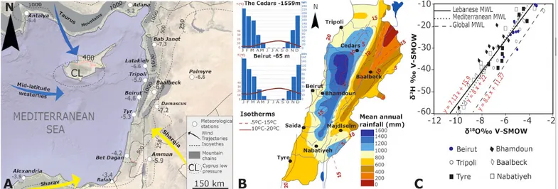
The Levant region in general is mainly influenced by the mid-latitude westerlies (Fig. 1A), which originate from the Atlantic Ocean, forming a series of subsynoptic low-pressure systems (Gat et al., 2003; Ziv et al., 2010) across the Mediterranean Sea. In winter, cold air plunging south over the relatively warm Mediterranean enhance cyclogenesis, creating the Cyprus Low (Alpert et al., 2005). This low-pressure system drives moist air onshore, generating intense orographic rainfall across the mountains of the northern Levant. The duration, intensity, and track of these storm systems strongly influence the rainfall amount in this region. In summer, the westerly belt is shifted to the north, following the northern shift of the North-African subtropical high pressures, and the region experiences hot and dry conditions with more southward winds. In Lebanon (Fig. 1B and 1C), the annual rainfall varies between 700 and 1000 mm along the coastline and more than 1400 mm in higher mountains with 4 months snow coverage (Shabaan et al., 2015). As a consequence of the above circulation system, the climate is seasonal with wet winters (November to February) and dry, hot summers (May to October). A general N-S gradient in rainfall amount and mirrored by the isotopic signal (δ18O and δ2H) is clearly evident from northern Syria
(Abou Zakhem & Hafez, 2010), to southern Israel/ Palestine (Gat et al., 2005). A West-East gradient, i.e. from the Levantine coastline to inner regions (Fig. 1A), is also visible as a consequence of the continental and/or altitudinal effects related to the Rayleigh distillation processes (Dansgaard, 1964; Rozanski et al., 1993).
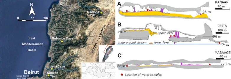
Four caves are selected at different altitudes along a transect from the coast to the Makmel Mountain, which is the highest peak in the Mount-Lebanon range (Fig. 2). These are: Kanaan Cave (96 m above sea level - asl), Jeita Cave (98 m asl), Mabaage Cave (770 m asl), and Qadisha Cave (1720 m asl).
Fig. 1. Climate and geographic setting of the study area. A) Eastern Mediterranean map showing the position of the mid latitude winds (http://iridl. ldeo.columbia.edu/Maproom), NS and EW precipitation gradients and δ18O mean values NS and EW precipitation gradients, of rainwater stations
over coastal and inner cities (Kailani et al., 2003; El-Asrag, 2004; Aouad-Rizk et al., 2005; Dirican et al., 2005; Gat el al, 2005; Saad et al., 2005; Abou Zakhem & Hafez, 2010; GNIP database); B) Precipitation gradients of Lebanon and histograms of Beirut and the Cedars with mean annual rainfall and temperature (Abi-Saleh & Safi, 1988; http://fr.climate-data.org); C) Rainwater isotope graph with several published meteoric waterlines: the Lebanese MWL in Saad et al. (2005), the Global MWL in Rozanski et al. (1993), and the Mediterranean MWL in Gat (1980).
Except for Qadisha Cave which is developed mainly in Quaternary deposits and Cretaceous limestones (Dubertret, 1975), Mabaage, Jeita and Kanaan caves develop in the middle Jurassic Kesrouane Formation, a faulted micritic limestone and dolomite sequence (Walley, 1998). The studied caves (Table 1) are located in the western flank of Mount-Lebanon (Fig. 1) along a N-S altitudinal transect. All four caves were previously studied for their speleothem content (Verheyden et al., 2008a; Cheng et al., 2015; Nehme et al., 2015, 2018).
Kanaan Cave (162 m long) is located 15 km northeast of Beirut. This fossil cave was discovered after quarrying activity in the late 1990s (Nehme et al., 2009). The Jeita multi-level system cave, located at 4.5 km distance from the coast, hosts a series of
dry and active galleries (Karkabi, 1990), a permanent stream with a discharge of 1 to 25 m3/s (Doummar,
2012) and is the most visited show cave in Lebanon. A 75 m deep canyon connects fossil galleries with the lower galleries in the downstream extremity of the 10 km karstic network, making the cave a well-ventilated system (Fig. 2). Mabaage Cave 400 m long, located at 40 km northeastern of Beirut and in the inner part to the Fidar valley (Jabbour-Gedeon & Zaatar, 2013) was recently transformed into a touristic cave during summer but closes in winter due to flooding of the cave stream. Finally, Qadisha Cave, located in the northern part of Mount-Lebanon, hosts a permanent spring with a discharge rate up to 1 m3/s (Edgell, 1997). Qadisha cave was partially
transformed into a touristic cave in 1934.
The vegetation cover above the caves mainly develops in shallow Mediterranean soil. Between 100 and 800 m asl, the vegetation consists of densely evergreen shrubs (juniper, oaks, and partially pine
Fig. 2. The study area and cross-sections of A) Kanaan Cave (Nehme et al., 2013); B) Jeita Cave (Karkabi, 1990; Nehme, 2013); C) Mabaage Cave
(Zaatar et al., 2013). For the cross-sec`tion of Qadisha Cave, see Tawk et al. (2008). Red stars indicate the location of water samples taken inside each cave and cave elevations are in m above sea level (asl). Refer to Table 1 for additional cave site data.
trees) growing on calcareous slopes above Kanaan, Jeita and Mabaage caves. The vegetation cover above Qadisha Cave (1720 m asl) is composed of sparse herbs, shrubs, and conifers (Table 1).
Cave Coordinates Cave type Entrance (m) Infiltration basin
elevation (m) Aspect
Length
(m) Host Rock Vegetation type Kanaan 33°54'25"N; 35°36'25"E Horizontal, relict 98 547 SE-NW 162 J4-J5 dense garrigue, pine forest Jeita upper 33°56'35"N; 35°38'48"E Horizontal, relict 96 1067 N-S 1300 J4-J5 dense garrigue, pine forest Jeita Lower 33°56'35"N; 35°38'48"E Horizontal, active 60 1669 E-W 8750 J4-J6 dense garrigue, pine forest Mabaage 34°06'25"N; 35°46'01"E Descending cave 770 1379 E-W 400 J6 sparse garrigue, oaks, pine Qadisha 34°14'38"N; 36°02'11"E horizontal, spring 1720 2244 NE-SW 1076 Q; C4 shrubs, conifer Sparse hurbs,
Table 1. Locations, morphology of the studied caves, and their soil characteristics.
SAMPLES AND METHODS
A total of 35 cave drip water and 12 underground stream water samples were collected in the Jeita and Qadisha caves for δ18O and δ2Η analyses, respectively.
The samples were obtained during two sampling campaigns: a first one held in September 2011 in Jeita and Qadisha caves and a second one between
September and November 2014 in Jeita, Qadisha, Mabaage, and Kanaan caves.
Temperature and pCO2 of cave air were measured
using a hand thermometer with a precision of 0.5°C and a Dräger pump system (σ ± 50 ppmv), respectively. Continuous temperature monitoring using a Niphargus (Burlet et al., 2015) temperature logger (precision of 0.1°C and resolution of 0.05°C)
was pursued from December 2015 to March 2017 in Qadisha and Jeita caves with one measurement every 20 minutes.
Isotopic analyses of cave waters collected in 2014 were carried out using a PICARRO L2130-i Cavity Ring-Down Spectrometer (CRDS) at the Vrije Universiteit Brussel. Measured values were corrected using three house standards calibrated against the international VSMOW2, GISP, and SLAP2 standards following the method described in De Bondt et al., (2018). Analytical uncertainties (2σ) equal 0.06‰ for δ18Ovalues and 0.3‰ for δ2H values. Water samples
collected were analyzed in 2011 at the Laboratoire des Sciences du Climat et de l’Environnement (LSCE-CEA), Paris. Hydrogen isotopes were measured on an ISO-PRIME mass spectrometer and a PICARRO CRDS with a 1 sigma error of ±0.7‰. Oxygen isotopes were analyzed using a Finnigan MAT 252 by equilibration with CO2. The 2 sigma error of the δ18O is ±0.05‰. All
values obtained from both laboratories are calibrated against and reported in permill (‰) relative to Vienna Standard Mean Ocean Water (V-SMOW2).
To calculate the altitudinal gradient of the cave dripwaters with respect to the altitude of the entrance and the infiltration basin of the studied caves, the infiltration basin elevation (Table 1) was derived after plotting the georeferenced caves maps on a Digital Elevation Model (DEM) using a Geographical Information System (ArcGIS). The infiltration watershed area of the cave is defined by considering the altitudes between the cave entrance and the limit of the
surface watershed. The underground waterflow main directions identified in Hakim (1985) and Hakim et al. (1988) for the Lebanese karst basins were considered to derive the most significant infiltration surface above the caves. The mean altitude is then calculated for the delimited infiltration basin for each cave using the DEM. Note that the Jeita Cave develops on two-levels (an upper fossil and a lower active gallery) thus has two different infiltration elevations.
RESULTS
Cave air temperature and pCO2
Cave air and underground stream temperatures, measured at different sites inside each cave (see
Supplementary Data), a fairly constant (Fig. 3A) with variations of less than 1°C over the sampling period. The measured air temperatures in Kanaan (19°C ± 0.5), Jeita upper (20°C ± 0.5), Mabaage (13°C ± 0.5), and Qadisha caves (9°C ± 0.5) all display autumn values roughly in agreement with the outside mean temperature (Fig. 3B) data (Karam, 2002), despite the small offset compared to the surface temperature trendline and some small internal changes (up to 0.3°C) as shown by the continuous monitoring data in Jeita and Qadisha (Fig. 3C).
As for the pCO2 concentrations in each cave, the
measured values reached 3,600 and 8,000 ppmv in Jeita and Mabaage caves respectively, whereas low values (600 ppmv) close to the atmospheric concentrations are detected in Qadisha Cave (see Supplementary Data).
Fig. 3. A) Cave-air and underground stream temperature measurements collected each month in both 2011 and 2014 171 campaigns; B) cave-air temperature trendline (black line) vs the cave entrance altitude. The cave-air-temperature trendline from compiled data of Lebanese meteorological stations (Karam, 2002) is represented in red line; C) continuous cave-air temperature monitoring from November 2014 to March 2017 for Qadisha and from January 2016 to March 2017 for Jeita Cave.
Cave dripwater δ18O and δ2H
Cave dripwaters and stream waters δ18O and
δ2H are summarized in Table 2 and detailed in the
Supplementary Data. Jeita Cave dripwaters exhibit an average of -5.7 ± 1.1‰ for δ18O and –26.6 ± 6.9‰
for δ2H (Table 2), with an amplitude of 2.9 and 20.5‰,
respectively. As for Kanaan Cave, measurements show an average of -5.40 ± 0.04‰ for δ18O and –24.0 ± 0.2‰
for δ2H (Table 2), with an amplitude of 0.2 and 0.5‰
respectively. Mabaage Cave located at higher altitude (770 m) shows an average of -7.2 ± 0.6‰ for δ18O and
–36.6 ± 6.2‰ for δ2H, whereas the amplitude varies
between 1.8 and 14.0‰, respectively.
Qadisha Cave, located at the highest altitude in our study area, shows an average of -8.48 ± 0.05‰ for δ18O and –46.1 ± 0.31‰ for δ2H with an amplitude
of 0.2 and 1.1‰, respectively. The variability of the dripwater oxygen isotopic signal in Kanaan (avg. -5.4‰) and Qadisha (avg. -8.5‰) does not exceed ±0.1‰ (Table 2). Drip water values in both Jeita and Qadisha caves show lower isotopic values than Jeita (avg. -7.2‰) and Qadisha (avg. -9.0‰) stream waters. However, the difference is much higher between dripwater and stream water isotopic values in Jeita Cave (~1.5‰) than those of Qadisha Cave (~0.4‰).
Table 2. Summary of the isotopic results of the drip and stream waters collected from the studied caves. Note that Jeita upper is the fossil cave and Jeita lower in the active cave with a permanent stream. (n) is the number of samples and oxygen isotopic composition ranges. The mean (avg.), maximum and minimum values of the δ18O drip and stream water and mean (avg.) of the δ2H of the autumn values, are
reported in ‰ VSMOW.
Fossil Caves n Dripwater δ18O (‰ VSMOW) Dripwater δ2H (‰ VSMOW)
min max avg. 2s avg. 2s
Kanaan 6 -5.48 -5.37 -5.43 ±0.04 –24 ± 0.2
Jeita Upper 11 -6.92 -4.05 -5.71 ±1.11 –26.6 ± 6.9
Mabaage 8 -8.28 -6.64 -7.18 ±0.66 -36.6 ± 6.2
Qadisha 10 -8.55 -8.38 -8.48 ±0.05 -46.1 ± 0.3
Cave Streams n Stream water δ18O (‰ VSMOW) Stream water δ2H (‰ VSMOW)
min max avg. 2s avg. 2s
Jeita lower 6 -7.35 -7.17 -7.28 ±0.06 -35.73 ± 0.48
Qadisha 6 -8.96 -8.92 -8.95 ±0.02 -49.24 ± 0.26
DISCUSSION
In order to determine if the current spatial gradients in rainwater isotopic composition are recorded in the cave dripwater, we discuss i) the available meteoric water lines of Lebanon and their altitudinal trends,
ii) the cave waters δ18O/δ2H signals compared to
the available δ18O/δ2H rainwater data, and iii) the
altitudinal trend in rainwater δ18O/δ2H and the
potential altitudinal trends in cave water δ18O to test
for their agreement.
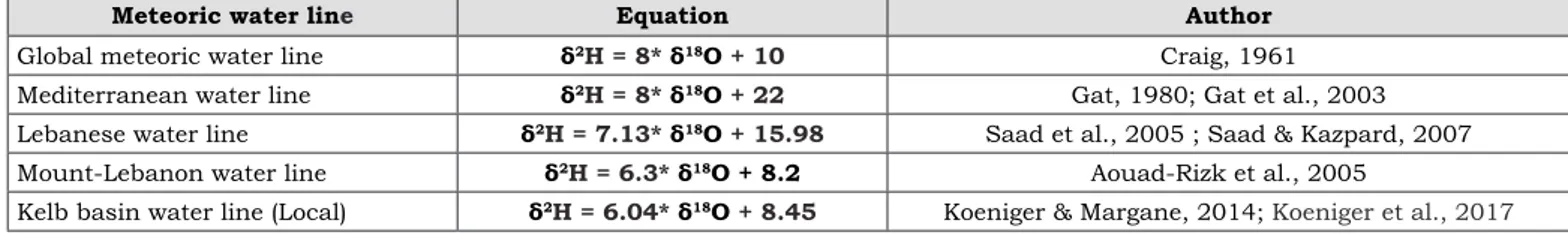
Rainwater data of Lebanon: different meteoric water lines and altitudinal trends
Several studies on the rainwater isotopic signal in Lebanon (Aouad-Rizk et al., 2005; Saad et al., 2005; Saad and Kazpard, 2007; Koeniger & Margane, 2014; Koeniger et al., 2017) exist in the literature
Table 3. Summary of the Global MWL and the MWLs previously calculated for the Mediterranean, Lebanon and Kelb basin.
(Table 3). The trendline slopes of the MWL (Lebanon, Mount-Lebanon, etc.) are different than that of the Mediterranean MWL, due mainly to a secondary evaporation effect during rainfall events (Saad et al., 2005; Saad & Kazpard, 2007). The evaporation occurs mostly during hot (dry) seasons and is particularly impacting light rains. Consequently, this process will determine the lowering of the slope and the “d-excess” value of the rain sample (Clark & Fritz, 1997).
In general, the constructed Lebanese Meteoric water lines based on δ18O and δ2H data of rainwater are
roughly in agreement with a general depletion trend with elevation. However, the local MWL (Koeniger & Margane, 2014; Koeniger et al., 2017) for the Kelb basin, the Mount-Lebanon (Aouad-Risk et al., 2005) and the general Lebanese MWL (Saad et al., 2005; Saad & Kazpard, 2007) are calculated based on different locations of the meteorological stations (Fig. 4A).
Meteoric water line Equation Author
Global meteoric water line δ2H = 8* δ18O + 10 Craig, 1961 Mediterranean water line δ2H = 8* δ18O + 22 Gat, 1980; Gat et al., 2003 Lebanese water line δ2H = 7.13* δ18O + 15.98 Saad et al., 2005 ; Saad & Kazpard, 2007 Mount-Lebanon water line δ2H = 6.3* δ18O + 8.2 Aouad-Rizk et al., 2005
Kelb basin water line (Local) δ2H = 6.04* δ18O + 8.45 Koeniger & Margane, 2014; Koeniger et al., 2017
The MWL after Aouad-Risk et al. (2005) referred here as the Mount-Lebanon MWL, is constructed using data from meteorological stations which display the same E-W trend than the stations used for the MWL of the Kelb basin (Koeniger & Margane, 2014). Indeed, the MWL after Aouad-Risk et al. (2005) and the local MWL after Koeniger & Margane (2014) show the same gradient (Table 3).
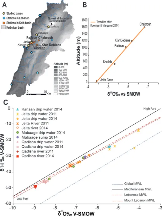
The altitudinal trendline (Fig. 4B) used in this study is constructed after the latest rainwater data (Koeniger & Margane, 2014; Koeniger et al., 2017) from stations located in the Kelb basin (central Mount-Lebanon) since the collected data covers an elevation range up to 1600 m (Chabrouh station) close to the basin altitude of the studied caves and includes snowfall isotopic signals. This altitudinal trendline show a linear δ18O-altitude relation of -0.13‰/100 m in West
Mount-Lebanon (Fig. 4B), i.e., a decrease in rainwater δ18O of 0.13‰ per 100 meters altitudinal increase.
Cave waters δ18O/δ2H signals compared to the available δ18O/δ2H rainwater data
The isotopic results of cave waters (drip and stream) of the four studied caves fall well on the Mount Lebanon MWL (Aouad-Risk et al., 2005), except for some of the Jeita Cave dripwaters (Fig. 4C). In general, Kanaan, Jeita, Mabaage and Qadisha δ18O
water (drip
and stream) values seems to fall more closely to the Mount Lebanon and Lebanese MWL than the regional Mediterranean MWL (Gat, 1980; Gat et al., 2003).
The δ18O
drip values of Kanaan Cave are at the lower
part of both Lebanese and Mount-Lebanon MWLs whereas Mabaage δ18O
drip values are located at the
center. δ18O
drip values of Qadisha cave correspond to
the highest part on both MWLs. Both Qadisha and Jeita δ18O
drip results of 2014 fall generally close to the
Lebanese MWL trend. Jeita δ18O
drip results of 2011
show a distinct displacement to the right of the Mount Lebanon MWL, that clearly indicates evaporation
processes (Saad & Kazpard, 2007). The positive δ18O
drip values of the 2011 campaign in Jeita Cave (Fig.
4C) suggest several processes and factors that might explain this particularity. Mickler et al. (2004) and Day and Handerson (2011) showed that the evaporation effect often occurs in caves with higher cave-air
Fig. 4. Summary of major cave drip and stream water δ18O and δ2H values plotted on the available
meteoric water lines (MWL) with the location of their meteorological stations. A) location of the studied caves (yellow stars) and the meteorological stations (blue circles) in Saad et al. 2005 and Saad & Kazpard, 2007 and (orange circles) in Koeniger & Margane, 2014; B) the altitudinal trendline used in this study and derived from the Local MWL of 222 the Kelb basin (Koeniger & Margane, 2014); C) δ18O and δ2H
values of 47 dripwater and stream samples plotted on the available MWLs.
temperatures, which is the case for Jeita Cave (20°C), and less so for Qadisha Cave (9°C). Another possibility is related to other cave environment parameters which include enhanced ventilation (Muhlinghaus et al., 2009; Deininger et al., 2012) that would lead to enhanced out-of-equilibrium processes.
The δ18O values for stream waters in the Qadisha
and Jeita caves plot along the Mount Lebanon and Lebanese MWLs. The Qadisha stream water displays
δ18O values close to the drip water isotopic signal of
the same cave suggesting a similar water infiltration source for the vadose and the karst aquifer (phreatic) zones. However, the isotopic signal of Jeita stream exhibits higher values than the drip water isotopic signal in Jeita upper cave advocating for different infiltration reservoir for the unsaturated and saturated
zones. Indeed, the Jeita underground stream exhibits a δ18O signal which is very close to the average δ18O
signal of the highest karstic springs feeding the Kelb basin: Nabaa el-Labane spring at 1647 m (avg. -7.26‰) and Nabaa al-Assal spring at 1528 m (avg. -7.32‰) (Aouad-Rizk et al., 2005; Koeniger et al., 2017). The isotopic signals are also in agreement with the well-known infiltration basin (or recharge area) for the Jeita underground stream situated at a mean altitude of 1669 m asl (Table 1).
The spread of the isotopic values cave waters along the Mount Lebanon MWL is related to the variability in δ18O and δ2H in rainwater and therefore in cave drip water. This is mainly due to the spatial variability, inter-seasonal, or interannual variations in isotopic composition of rain. It suggests that all sampled dripwaters in the caves, especially in Jeita and less in Qadisha may be related to rainwater from different seasons or even years depending on the residence time of the water in the vadose, here epikarst zone.
The deuterium excess (d-excess) value is calculated from δ18O values and δ2H using this equation:
d-excess = δ2H – 8 * δ18O
The d-excess, an indicator for the source and trajectories of atmospheric moisture (Rozanski, 1993; Sharp, 2007), is associated with evaporation at the moisture source. The comparison of d-excessdrip vs
d-excessrain is necessary to understand if the measured
cave waters are controlled by a similar vapor source than the rainwater. The Eastern Mediterranean source waters have d-excess values ranging from 14‰ to 19‰ (Kattan, 1997), whilst they reach 15‰ (Frot et al., 2007) for Western Mediterranean sourced waters, and are close to 10‰ for Atlantic-sourced moisture.
The Lebanese MWL exhibit a d-excess of 15.98‰
which is within the range of the Eastern Mediterranean
waters’ values (Kattan, 1997). The d-excess for the dripwater in cave indicate a value of 16.25, which is close to the one defined by the Lebanese MWL (Aouad-Rizk et al., 2005; Saad & Kazpard, 2007; Koeniger & Margane, 2014).
Altitudinal trends in cave water δ18O
The Mediterranean air masses arriving from the west are orographically uplifted as they reach the Mount-Lebanon range. As the air rises and cools, the rainwater with a heavier isotope falls first, resulting in rainwater exhibiting more negative isotopic values with altitude (Bowen & Wilkinson, 2002). Globally, the average change in δ18O
rain is
-0.2‰ per 100 m elevation gain (Rozanski et al., 1993). Locally, we determined this trend as -0.13‰/100 m (Fig. 4B). In order to understand the altitude effect on the isotopic composition of cave water (drip and stream), the δ18O cave water
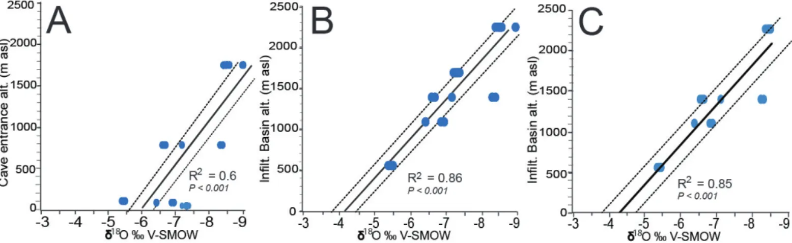
values are plotted first against altitude of the cave entrances (Fig. 5A).
Only the δ18O
drip and δ18Ostream values that fall closely
on the local MWL were retained for the altitudinal trend analysis (Fig. 5A). Figure 5A clearly shows a poor altitudinal trend when considering only the altitude of the cave entrance. However, there is a clear altitudinal trend with a regression coefficient R2 = 0.86 (P < 0.001) when considering the mean
altitude of the infiltration basin (or recharge area) of these caves (Fig. 5B and 5C). Indeed, the basin from where water infiltrates is at higher elevation relative to the cave entrance due to the thick limestone overburden and the topography above the caves entrance. The δ18O
water values of Jeita stream are a clear example
of that particularity, showing that the underground water originates from an infiltration basin at a higher altitude (avg. alt. 1669 m) than the cave entrance (60 m) (Doummar, 2012; Koeniger et al., 2017).
With the infiltration basin altitude (Table 1) taken into consideration here, all points fall within the 95% confidence interval (Fig. 5B and 5C) except one point, which represent cave waters taken from Mabaage Cave at the end of August 2014. All drip and stream waters δ18O values reach 0.2‰ per
100 m (Fig. 5B) with an overall offset of 0.07‰ compared to the rainwater trend of 0.13‰ per 100 m calculated form the trendline (Fig. 4B) after Koeniger & Margane (2014).
Comparable studies in the Mediterranean region showed different small offsets between altitudinal gradients for precipitation and dripwater δ18O values.
In the steep northern Italian Alps, eight caves aligned along two transects, show slightly different gradients of 0.15 and 0.08‰ in dripwater (Johnston et al., 2013). In the eastern Adriatic coast and Dinaric mountains (Croatia), the offset reaches up to 0.2‰ (Suric et al., 2016) similar to the offset measured in Mount-Lebanon cave waters.
Clearly, the Δδ18O/100 m value of the dripwater
(Fig. 5C) is site-specific, mainly due to: i) local processes that influence the δ18O
drip on its way to
the cave, such as those within the litter, soil, and epikarst (Beddows et al., 2016), ii) the relation to the precipitation altitude gradient (rainfall quantity, patterns, and frequencies above the cave infiltration
Fig. 5. Altitudinal trends in cave water δ18O (drips and streams). A) Adjusted linear regression between the δ18Ocave water and the altitude of the cave
entrance; B) δ18O
cave water and the altitude of the infiltration basin; C) Plot showing the δ18Odripwater trendline only vs the infiltration basin altitude. The
basin), or iii) the hilly topography above the cave and the limits of the calculated infiltration basin defined herein.
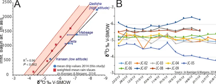
Figure 6A compares the offset between altitudinal gradients for precipitation and dripwater δ18O values.
Within the limit of the 95% confidence interval of the precipitation δ18O trendline and considering the
2σ sigma error of the dripwater, the drip δ18O values
fall generally close to the precipitation δ18O trendline
except for Qadisha Cave. There is, however, a minor negative offset (0.2‰ at low altitude to 1.2‰ at high altitude) between the dripwater and the precipitation δ18O trendline.
This offset, similar to the one observed for the Adige, Valsugana valleys, northern Italy (Johnston et al., 2013), the Adriatic coast (Suric et al., 2016), and Vancouver, Canada (Beddows et al., 2016) represents a bias due to the infiltration effects of rainwater. In winter, the infiltrated water from rainfall/snowmelt with lower δ18O values reaches the
Fig. 6. Cave dripwaters δ18O values in Lebanese caves compared to δ18Orain: A) trendline showing the mean δ18Odripwater (blue dots) of each cave
(this study) compared to the altitudinal trendline used in this study (red rectangles) and derived from the Local MWL (δ18O weighted-mean
rainwater values) after Koeniger & Margane (2014). The calculated interval of confidence (dashed line) for the δ18O weighted-mean rainwater
regression is 95% and the significance p-value is P < 0.002; B) δ18O
dripwater measured at nine different sampling sites (JC-01to 09) in Jeita Cave
on a yearly basis (data in Koeniger & Margane, 2014).
cave, while in summer seasons, 18O (2H)-enriched
water will partially evaporate in the unsaturated zone, especially when shallow overburden exists above the cave (Wackerbarth et al., 2010, 2012). The cave waters are therefore normally biased towards lower/lighter δ18O/δ2H values compared to the rainwater isotopic
signal (Wackerbarth et al., 2012).
Generally, cave dripwaters in Lebanon are mostly the result of percolation happening during the wet season (from autumn to spring snowmelt), with a longer infiltration period at higher altitudes due to snowmelt. For Qadisha Cave, which is located at a higher altitude, the offset between the precipitation δ18O trendline and the dripwaters isotopic signals
is the most negative when compared to the other studied caves. This is explained by the infiltration of winter water enhanced by a negative isotopic value of winter snow, especially at higher altitudes (Aouad-Rizk et al., 2005) and contributing into the vadose water budget.
Regarding the altitudinal effect on the 18O- and 2H-depleted dripwater, our study shows that δ18O
drip
values decrease up to 3‰ between Kanaan and Qadisha caves (Fig. 6A). This amplitude attributed to the altitudinal effect could theoretically be increased by variations in the δ18O
drip values related to
site-specific characteristics or to a seasonal bias between winter and summer dripwaters values transferred by the rainwater seasonal variations. Indeed, rainwater δ18O values in Lebanon show clearly a seasonal bias
with a variation up to 5‰ (Saad & Kazpard, 2007; Koeniger & Margane, 2014) between early-winter and winter-spring seasons. In fact, seasonal variations in meteoric precipitation may range up to >15‰ for δ18O (Genty et al., 2014). However, the majority
of cave sites studied around the world (Genty et al., 2014; Beddows et al., 2016) demonstrated that drip waters typically show little or no isotopic seasonality compared to the variations in meteoric precipitation. For instance, the δ18O
drip variability of caves in
Vancouver Island, Canada is reduced in amplitude by
60–90% compared to the Victoria rainfall records of the same year. In Villars, Chauvet, and Orgnac caves, southern France, the δ18O
drip values stayed stable for
15 years with little seasonal variations compared to drip rate measurement. In Lebanon, our δ18O
drip
data, even though stable during the autumn season prevent us from assessing a seasonal variability for all four cave sites. However, a previous campaign on dripwater isotopic measurement completed at nine drip sites in Jeita Cave (Koeniger & Margane, 2014) show little variability at each drip site over a complete rainy and early-summer season (Fig. 6B), but rather a spatial variability between each drip site. Indeed, the maximum seasonal variability of 1‰ is only recorded in JC-05 site (Fig. 6B). The δ18O
drip yearly average
is -5.24‰ in Jeita cave showing a low seasonal variability with a standard deviation of ±0.48. Therefore, the seasonal variations in cave dripwaters as seen in Jeita δ18O
drip measurement, account less in
the altitudinal effect on the lowering of the dripwater isotopic values.
Implications for future speleothems-based paleoclimate studies
The isotopic signal of the dripwater in Lebanese caves located on the western flank of Mount-Lebanon falls generally on the local MWL (Koeniger & Margane, 2014) as well as the Mount-Lebanon MWL (Aouad-Rizk et al., 2005). This implies: i) an identical source of water being derived from rain forming over the Mediterranean basin as indicated by similar d-excess values of the water, ii) a reduced evapotranspiration effect, observable on only some samples with a clear offset to the right of the MWL, probably due to increased cave ventilation, and iii) a longer infiltration period occurring in the unsaturated zone at higher altitudes.
Whilst some exceptions might occur as seen in some drip water in Jeita Cave during the 2011 campaign, which were more exposed to ventilation at some locations, most of the cave dripwater exhibits a similar δ18O and δ2H signal as the local rainwater.
However, a slight offset towards lower ‘winter values’ may occur due to a preferential water recharge during winter months, including the recharge by melting snow.
Regarding the altitudinal trend observed in the rainwater over the Mount-Lebanon range (Fig. 4B), the isotopic signal in dripwater exhibits an altitudinal trend, but with a slightly different gradient (-0.21‰ per 100 m) than the rainwater (-0.13‰ per 100 m). This is however, more significant when the dripwater isotopic signal is compared to the altitude of the infiltration basin of each cave (Fig. 5C).
CONCLUSION
The preliminary dripwater isotopic measurements and temperature conducted on four caves located in the western flank of Mount-Lebanon, revealed the following important conclusions for future speleothem-based interpretation of paleoclimate changes at both local and regional scales:
• Despite for some water samples influenced by evaporative processes, the drip water exhibits isotopic values in agreement with the local rainwater. Therefore, stalagmites for paleoclimatic reconstructions (or fluid inclusion analysis) should be preferentially chosen outside a possible ventilation-influenced area of the cave.
• The altitudinal trend confirmed previously in the rainwater isotopic composition on the western flank of Mount-Lebanon is demonstrated also in cave drip water indicating the transfer to the cave through the vadose zone of the spatial isotopic signals of the rainwater. The isotopic composition of the dripwaters, however, exhibits a slightly higher negative δ18O/100 m gradient for cave drip
water due to slower infiltration of winter waters. The isotopic dripwater signal represents therefore mostly a lower limit of the isotopic signal of the corresponding rain/snow melt.
• The results of this study can further help in the interpretation of past altitudinal trends based on speleothems. Additional future cave water
and calcite monitoring with automated logging equipment (pCO2, temperature, humidity, etc.)
will continue to refine the interpretations that have been based on the initial monitoring findings presented here.
• To build further on this study, the altitudinal trend signal should be confirmed by modern calcite from the same caves, in which the trend should have a similar gradient.
ACKNOWLEDGMENTS
This study was funded by the 2014 mobility fellowship program of the Belgian Federal Scientific Policy (BELSPO), co-funded by the Marie Curie Actions of the European Commission, and the European Union’s Horizon 2020 Research. Laboratory analysis conducted at LSCE-Paris were funded under the MISTRALS research program. We acknowledge the assistance of St-Joseph University of Beirut for facilitating the access to caves with the help of ALES (Association Libanaise d’Etudes Spéléologiques) and SCL (Spéléo-Club du Liban) and the support of both caving club members who collected water and calcite samples during field campaigns. The authors are grateful to Bogdan Onac for his editorial handling of the manuscript and endless patience and especially to the two anonymous reviewers for their constructive comments and revisions that considerably improved the quality of the manuscript.
REFERENCES
Abi-Saleh B. & Safi S., 1988 – Carte de la végétation du
Liban. Ecologia Mediterranea, 14: 123-141.
Abou Zakhem A. & Hafez R., 2010 – Climatic factors
controlling chemical and isotopic characteristics of precipitation in Syria. Hydrological Processes, 24:
2641-2654.
https://doi.org/10.1002/hyp.7646
Aouad-Rizk A., Job J.O., Khalil S., Touma T., Bitar C., Bocquillon C. & Najem W., 2005 – δ18O and δ 2H contents
over Mount-Lebanon related to mass trajectories and local parameters. In: Isotopic composition of precipitation in the Mediterranean Basin in relation to air circulation patterns and climate. IAEA-TECDOC, 1453: 75-82.
Alpert P., Price C., Krichak S.O., Ziv B., Saaroni H., Osetinsky I. & Kishcha P., 2005 – Tropical teleconnections
to the Mediterranean climate and weather. Advances in
Geosciences, 2: 157-160.
https://doi.org/10.5194/adgeo-2-157-2005
Baldini J.U.L., McDermott F. & Fairchild I.J., 2006 –
Spatial variability in cave drip water hydrochemistry: Implications for stalagmite paleoclimate records.
Chemical Geology, 235: 390-404.
https://doi.org/10.1016/j.chemgeo.2006.08.005 Baker A., Barnes W. & Smart P., 1997 – Variations in the
discharge and organic matter content of stalagmite drip waters in Lower Cave, Bristol. Hydrological Processes,
11: 1541-1555.
https://doi.org/10.1002/(SICI)1099-1085(199709)11: 11%3C1541::AID-HYP484%3E3.0.CO;2-Z
Bar-Matthews M., Ayalon A., Matthews A., Sass E. & Halicz L., 1996 – Carbon and oxygen isotope study of the active
cave: implications for paleoclimate research in semiarid regions. Geochimica Cosmochimica Acta, 60: 337-347. https://doi.org/10.1016/0016-7037(95)00395-9 Bar-Matthews M., Ayalon A., Gilmour M., Matthews
A. & Hawkesworth C.J., 2003 – Sea-land oxygen
isotopic relationships from planktonic foraminifera and speleothems in the Eastern Mediterranean region and their implication for paleorainfall during interglacial intervals. Geochimica Cosmochimica Acta, 67: 3181-3199. https://doi.org/10.1016/S0016-7037(02)01031-1 Beddows P.A., Mandic M., Ford D.C. & Schwarcz H.P.,
2016 – Oxygen and hydrogen isotopic variations
between adjacent drips in three caves at increasing elevation in a temperate coastal rainforest, Vancouver Island, Canada. Geochimica Cosmochimica Acta, 172:
370-386. https://doi.org/10.1016/j.gca.2015.08.017 Bowen G.J. & Wilkinson B., 2002 – Spatial distribution
of δ18O in meteoric precipitation. Geology, 30: 315-318.
https://doi.org/10.1130/0091-7613(2002)030%3C03 15:SDOOIM%3E2.0.CO;2
Burlet C., Vanbrabant Y., Piessens K., Welkenhuysen K. & Verheyden S., 2015 – Niphargus: a silicon band-gap
sensor temperature logger. Computers & Geosciences,
74: 50-59.
https://doi.org/10.1016/j.cageo.2014.10.009
Cheng H., Sinhac A., Verheyden S., Nader F.H., Li X.L., Zhang P.Z., Yin J.J., Yi L., Peng Y.B., Rao Z.G., Ning Y.F. & Edwards R.L., 2015 – The climate variability in
northern Levant over the past 20,000 years. Geophysical
Research Letters, 42: 8641-8650.
https://doi.org/10.1002/2015GL065397
Day C.C. & Henderson G.M., 2011 – Oxygen isotopes
in calcite grown under cave-analogue conditions.
Geochimica Cosmochimica Acta, 75: 3956-3972. https://doi.org/10.1016/j.gca.2011.04.026
Dansgaard W., 1964 – Stable isotopes in precipitation. Tellus, 16: 438-468.
https://doi.org/10.3402/tellusa.v16i4.8993
Deininger M., Fohlmeister J., Scholz D. & Mangini A., 2012 – Isotope disequilibrium effects: The influence of
evaporation and ventilation effects on the carbon and oxygen isotope composition of speleothems - A model approach. Geochimica Cosmochimica Acta, 96: 57-79. https://doi.org/10.1016/j.gca.2012.08.013
De Bondt K., Seveno F., Petrucci G., Rodriguez F., Joannis C. & Claeys P., 2018 – Potential and limits of
stable isotopes (δ18O and δ2H) to detect parasitic water in
sewers of oceanic climate cities. Journal of Hydrology:
Regional Studies, 18: 119-142.
https://doi.org/10.1016/j.ejrh.2018.06.001
Dirican A., Unal S., Acar Y. & Demircan M., 2005 –
The temporal and seasonal variation of δ 2H and δ 18O
in atmospheric water vapour and precipitation from Ankara, Turkey in relation to air mass trajectories at Med. Basin. In: Isotopic composition of precipitation in the Mediterranean Basin in relation to air circulation patterns and climate. IAEA-TECDOC, 1453: 191-214.
Doummar J., 2012 – Identification of indicator parameters
for the quantitative assessment of vulnerability in karst aquifers. Unpublished Thesis, University of Gottingen,
Gottingen, 116 p.
Dubertret L., 1975 – Introduction à la carte géologique au 1/50000e du Liban. Notes et Mémoires sur le
Moyen-Orient, 23: 345-403.
El-Asrag A.M., 2005 – Effect of synoptic and climatic
situations on fractionation of stable isotopes in rainwater over Egypt and east Mediterranean. In: Isotopic composition of precipitation in the Mediterranean Basin in relation to air circulation patterns and climate. IAEA-TECDOC, 1453: 51-73.
Edgell H.S., 1997 – Karst and hydrogeology of Lebanon.
Carbonates and Evaporites, 12 (2): 220-235. https://doi.org/10.1007/BF03175419
Frot E., Van Wesemael B., Vandenschrick G., Souchez R. & Benet A.S., 2007 – Origin and type of rainfall
for recharge of a karstic aquifer in the western Mediterranean: a case study from the Sierra de Gador-Campo de Dalias (southeast Spain). Hydrological
Processes, 21: 359-368.
https://doi.org/10.1002/hyp.6238
Fairchild I.J. & Baker A., 2012 – Speleothem science:
from process to past environments. Wiley-Blackwell,
Chichester, 450 p.
https://doi.org/10.1002/9781444361094
Friedman I. & O’Neil J.R., 1977 – Data of geochemistry:
Compilation of stable isotope fractionation factors of geochemical interest. United States Geological Survey, Washington, USA, 170 p.
Fohlmeister J., Scholz D., Kromer B. & Mangini A., 2011 – Modelling carbon isotopes of carbonates in cave drip
water. Geochimica Cosmochimica Acta, 75: 5219-5228. https://doi.org/10.1016/j.gca.2011.06.023
Ford D. & Williams P., 2007 – Karst hydrogeology and
geomorphology. John Wiley & Sons, Chichester, 562 p.
https://doi.org/10.1002/9781118684986
Frisia S. & Borsato A., 2010 – Karst. In: Alonso-Zarza A.M. & Tanner L.H. (Eds.), Developments in sedimentology,
carbonates in continental settings. Elsevier, Amsterdam,
p. 269-318.
https://doi.org/10.1016/S0070-4571(09)06106-8 Gat J., 1980 – The isotopes of hydrogen and oxygen
in precipitation. In: Fritz P. & Fontes J.Ch. (Eds.), Handbook of environmental isotope geochemistry, 1:
22-48.
Gat J.R., Klein B., Kushnir Y., Roether W., Wernli H., Yam R. & Shemesh A., 2003 – Isotope composition of
air moisture over the Mediterranean Sea: an index of the air–sea interaction pattern. Tellus, Series B-Chemical &
Physical Meteorology, 55 (5): 953-965.
https://doi.org/10.1034/j.1600-0889.2003.00081.x Gat J.R., Ben-Mair R., Yama R., Yakir D. & Wernli H.,
2005 – The Isotope Composition of Atmospheric Waters
in Israel’s Coastal Plain. In: Isotopic composition of precipitation in the Mediterranean Basin in relation to air circulation patterns and climate. IAEA-TECDOC,
1453: 99-114.
Genty D., Blamart D., Ghaleb B., Plagnes V., Causse C.h., Bakalowicz M., Zouari K., Chkir N., Hellstrom J., Wainer K. & Bourges F., 2006 – Timing and dynamics
of the last deglaciation from European and North African δ13C stalagmite profiles– comparison with Chinese and
South Hemisphere stalagmites. Quaternary Science
Reviews, 25: 2118-2142.
https://doi.org/10.1016/j.quascirev.2006.01.030 Genty D., Labuhn I., Hoffmann G., Danis P.A., Mestre
O., Bourges F., Wainer K., Massault M., Van Exter S., Régnier E., Orengo Ph., Falourd S. & Minster B., 2014 – Rainfall and cave water isotopic relationships in two
South-France sites. Geochimica Cosmochimica Acta
131: 323-343.
https://doi.org/10.1016/j.gca.2014.01.043
Hellstrom J., McCulloch M. & Ston J., 1998 – A detailed
31.000-year record of climate and vegetation change, from the isotope geochemistry of two New Zealand speleothems. Quaternary Research, 50: 167-178. https://doi.org/10.1006/qres.1998.1991
Hendy C.H., 1971 – The isotopic geochemistry of
speleothems-I: The calculations of the effects of different modes of formation on the isotopic composition
of speleothems and their applicability as paleoclimate indicators. Geochimica Cosmochimica Acta, 35: 801-824. https://doi.org/10.1016/0016-7037(71)90127-X Hendy C.H., Wilson A.T., Popplewell K.B. & House
D.A., 1977 – Dating of geochemical events in Lake
Bonney, Antarctica, and their relation to glacial and climate changes. New Zealand Journal of Geology &
Geophysics, 20 (6): 1103-1122.
https://doi.org/10.1080/00288306.1977.10420698 Hakim B., 1985 – Recherche hydrologiques et hydrochimiques
sur quelques karsts méditerranéens: Liban, Syrie, Maroc.
PhD thesis, Lebanese University Beirut, Lebanon, 700 p. Hakim B. & Karakabi S., 1988 – Coloration du gouffre
de Faouar Dara et de la grotte de Kassarat.
Al-Ouate-Ouate Spéléo-Club du Liban, 3: 18-33.
International Atomic Energy Agency/World Meteorological Organization (2008) Global network of isotopes in precipitation. The GNIP Database.
https://nucleus.iaea.org/Pages/GNIPR.aspx (Accessed date: May 2016)
Jabbour-Gedeon B. & Zaatar J., 2013 – Mgharet
Mabaage: nouvelles découvertes et aménagement touristique “surprenant”. Spéléorient, Association
libanaise d’Etudes spéléologiques, 6: 61-67.
Johnston V.E., Borsato A., Spötl C., Frisia S. & Miorandi R., 2013 – Stable isotopes in caves over altitudinal
gradients: fractionation behaviour and inferences for speleothem sensitivity to climate change. Climate of the
Past, 9: 99-118.
https://doi.org/10.5194/cp-9-99-2013
Karam F., 2002 – Climate change and variability in
Lebanon: impact on land use and sustainable agriculture development. Proceedings of the 1st technical workshop of the “Mediterranean” component of CLIMAGRI project on climate change and agriculture, FAO, Rome, 25-27. Karkabi S., 1990 – Cinquantenaire de la spéléologie
libanaise. Al-Ouate-Ouate, special edition, 138 p.
Kattan Z., 1997 – Environmental isotope study of the
major karst springs in Damascus limestone aquifer systems: case of the Figeh and Barada springs. Journal
of Hydrology, 193 (1-4): 161-182.
https://doi.org/10.1016/S0022-1694(96)03137-X Koeniger P. & Margane A., 2014 – Stable isotope
investigations in the Jeita Spring catchment. BGR,
Special report on protection of Jeita Spring, 12, 48 p. Koeniger P., Margane A., Abi-Rizk J. & Himmelsbach T.,
2017 – Stable isotope based mean catchment altitudes of springs in the Lebanon Mountains. Hydrological
Processes, 21: 3708-3718.
https://doi.org/10.1002/hyp.11291
Luetscher M. & Jeannin P.-Y., 2004 – Temperature
distribution in karst systems: the role of air and water fluxes. Terra Nova, 16: 344-350.
https://doi.org/10.1111/j.1365-3121.2004.00572.x Lachniet M.S., 2009 – Climatic and environmental controls
on speleothem oxygen isotope values. Quaternary
Science Reviews, 28: 412-432.
https://doi.org/10.1016/j.quascirev.2008.10.021 Mattey D., Fairchild I., J. Atkinson T.C., Latin J.-P.,
Ainsworth M. & Durell R., 2010 – Seasonal microclimate
control of calcite fabrics, stable isotopes and trace elements in modern speleothem from St Michaels Cave, Gibraltar. In: Pedley H.M. & Rogerson M. (Eds.), Tufas and speleothems: Unravelling the microbial and physical controls. Geological Society, London, Special
Publications, 336: 323-344. https://doi.org/10.1144/SP336.17
McDonald J. & Drysdale R., 2007 – Hydrology of cave drip
waters at varying bedrock depths from a karst system
in southeastern Australia. Hydrological Processes, 21:
1737-1748. https://doi.org/10.1002/hyp.6356 Mickler P.J., Banner J.L., Stern L., Asmerom Y., Edwards
R.L. & Ito E., 2004 – Stable isotope variations in modern
tropical speleothems: Evaluating equilibrium vs. kinetic isotope effects. Geochimica Cosmochimica Acta, 68:
4381-4393.
https://doi.org/10.1016/j.gca.2004.02.012
Miorandi R., Borsato A., Frisia S., Fairchild I.J. & Richter D.K., 2010 – Epikarst hydrology and implications for
stalagmite capture of climate changes at Grotta di Ernesto (NE Italy): results from long-term monitoring.
Hydrological Processes, 24: 3101-3114. https://doi.org/10.1002/hyp.7744
Mhawej M., Faour G., Fayad A. & Shaban A., 2014 – Towards an enhanced method to map snow cover areas and derive snow-water equivalent in Lebanon. Journal
of Hydrology, 513: 274-282.
https://doi.org/10.1016/j.jhydrol.2014.03.058
Muhlinghaus C., Scholz D. & Mangini A., 2009 – Modelling fractionation of stable isotopes in stalagmites. Geochimica Cosmochimica Acta, 73: 7275-7289. https://doi.org/10.1016/j.gca.2009.09.010
Nehme C., Jabbour-Gedeon B., Gerard P.-C., Sadier B. & Delannoy J.J., 2009 – Reconstitution sepéléogénique
de la grotte de Kanaan (Antelias, Liban): contribution à la morphogenèse du Nahr Antélias. Karstologia, 54: 21-30. Nehme C., Verheyden S., Noble S.R., Farrant A.R., Sahy
D., Hellstrom J., Delannoy J.J. & Claeys P., 2015 – Reconstruction of MIS 5 climate in the central Levant using a stalagmite from Kanaan Cave, Lebanon. Climate
of the Past, 11: 1785-1799.
https://doi.org/10.5194/cp-11-1785-2015
Nehme C., Verheyden S., Breitenbach S.F., Gillikin D.P., Verheyden A., Cheng H., Edwards R.L., Hellstrom J., Noble S.R., Farrant A.R. & Sahy D., 2018 – Climate
dynamics during the penultimate glacial period recorded in a speleothem from Kanaan Cave, Lebanon (central Levant). Quaternary Research, 90 (1): 1-16.
https://doi.org/10.1017/qua.2018.18
Peel M.C., Finlayson B. & McMahon Th., 2007 – Updated world map of the Köppen-Geiger climate classification.
Hydrological and Earth Systems Sciences Discussions,
4 (2): 439-473.
https://doi.org/10.5194/hessd-4-439-2007
Rozanski K., Araguas-Araguas L. & Gonfiantini R., 1993 – Isotopic patterns in modern global precipitation. Geophysical Monographical Series, 78: 1-36.
https://doi.org/10.1029/GM078p0001
Saad Z., V. Kazpard A.G. Samrani El. & Slim K., 2005
– Chemical and isotopic composition of rainwater in coastal and highland regions in Lebanon. Journal of
Environmental Hydrology, 13: 1-11.
Saad Z. & Kazpard V., 2007 – Seasonal effect on the
isotopic pattern of rainwater in Lebanon. Journal of
Environmental Hydrology, 15: 1-15.
Sharp Z., 2007– Principles of stable isotope geochemistry. Pearson Prentice Hall, New Jersey, 344 p.
Scholz D., Muhlinghaus C. & Mangini A., 2009 –
Modelling δ13C and δ18O in the solution layer on
stalagmite surfaces. Geochimica Cosmochimica Acta,
73: 2592-2602.
https://doi.org/10.1016/j.gca.2009.02.015
Spotl C., Fairchild I.J. & Tooth A.F., 2005 – Cave air
control on dripwater geochemistry, Obir Caves (Austria): Implications for speleothem deposition in dynamically ventilated caves. Geochimica Cosmochimica Acta, 69:
2451-2468.
Suric M., Loncaric R., Loncar N., Buzjak N., Bajo P. & Drysdale R., 2017 – Isotopic characterization of cave
environments at varying altitudes on the eastern Adriatic coast (Croatia) – Implications for future speleothem-based studies. Journal of Hydrology, 545: 367-380. https://doi.org/10.1016/j.jhydrol.2016.12.051 Tawk J. & Kaasamani H., 2014 – La grotte de Qadisha
- première grotte touristique du Liban. Al-Ouate-Ouate,
Spéléo-club du Liban, 14: 36-41.
Tremaine D.M., Froelich P.N. & Wang Y., 2011 – Speleothem
calcite farmed in situ: Modern calibration of δ18O and
δ13C paleoclimate proxies in a continuously monitored
natural cave system. Geochimica Cosmochimica Acta,
75: 4929-4950.
https://doi.org/10.1016/j.gca.2011.06.005
Van Geldern R. & Barth-Johannes A.C., 2012 –
Optimization of instrument setup and post-run corrections for oxygen and hydrogen stable isotope measurements of water by isotope ratio infrared spectroscopy (IRIS).
Limnology Oceanography Methods, 10: 1024-1036. https://doi.org/10.4319/lom.2012.10.1024
Verheyden S., Genty D., Deflandre G., Quinif Y. and Keppens E., 2008a – Monitoring climatological, hydrological and geochemical parameters in the Père Noël cave (Belgium): implication for the interpretation of speleothem isotopic and geochemical time-series.
International Journal of Speleology, 37 (3): 221-234. https://doi.org/10.5038/1827-806X.37.3.6
Verheyden S., Nader F.H., Cheng H.J., Edwards L.R. & Swennen R., 2008b – Paleoclimate reconstruction in
the Levant region from the geochemistry of a Holocene stalagmite from the Jeita cave, Lebanon. Quaternary
Research, 70: 368-381.
https://doi.org/10.1016/j.yqres.2008.05.004
Wackerbarth A., Langebroek P.M., Werner M., Lohmann G., Riechelmann S., Borsato A. & Mangini A., 2012 – Simulated oxygen isotopes in cave drip water and
speleothem calcite in European caves. Climate of the
Past, 8: 1781-1799.
https://doi.org/10.5194/cp-8-1781-2012
Wackerbarth A., Scholz D., Fohlmeister J. & Mangini A., 2010 – Modelling the δ18O value of cave drip water
and speleothem calcite. Earth and Planetary Science
Letters, 299 (3-4): 387-397.
https://doi.org/10.1016/j.epsl.2010.09.019
White B., 1988. Geomorphology and hydrology of karst
terrains. Oxford University Press, New York, 464 p.
Ziv B., Dayan U., Kuschnir Y., Roth C., Enzel Y., 2006 – Regional and global atmospheric patterns governing
rainfall in the southern Levant. International Journal of
Climatology, 26: 55-73.
https://doi.org/10.1002/joc.1238
Ziv B., Saaroni H., Romem M., Heifetz E., Harnik N. & Baharad. A., 2010 – Analysis of conveyor belts in
winter Mediterranean cyclones. Theoretical Applied
Climatology, 99: 441-455.