HAL Id: hal-00305626
https://hal.archives-ouvertes.fr/hal-00305626
Submitted on 17 Jan 2007HAL is a multi-disciplinary open access archive for the deposit and dissemination of sci-entific research documents, whether they are pub-lished or not. The documents may come from teaching and research institutions in France or abroad, or from public or private research centers.
L’archive ouverte pluridisciplinaire HAL, est destinée au dépôt et à la diffusion de documents scientifiques de niveau recherche, publiés ou non, émanant des établissements d’enseignement et de recherche français ou étrangers, des laboratoires publics ou privés.
Hydrological prediction in a non-stationary world
R. T. Clarke
To cite this version:
R. T. Clarke. Hydrological prediction in a non-stationary world. Hydrology and Earth System Sciences Discussions, European Geosciences Union, 2007, 11 (1), pp.408-414. �hal-00305626�
© Author(s) 2007. This work is licensed under a Creative Commons License.
Hydrological prediction in a non-stationary world
Robin T. Clarke
Instituto de Pesquisas Hidráulicas, Universidade Federal do Rio Grande do Sul, Porto Alegre, RS, Brazil Email: [email protected]
Abstract
The paper discusses evidence that common assumptions in the analysis of hydrological time series (homogeneous variability in random fluctuations about a constant mean value) may not be appropriate for some South American drainage basins. Relatively rapid changes have occurred, and are occurring, as a consequence of replacing mature forest by short crops and urban development. Some research claims to have detected non-linear trends in streamflow in rivers draining the south-eastern part of the sub-continent, together with decadal fluctuations and interannual peaks at ENSO timescales. The paper discusses the implications of such changes for hydrological practices now in widespread and largely unquestioned use.
Keywords: non-stationarity, river flow, South America
The changing view from the
watershed
On the first of January 1970, I came to work at the Institute of Hydrology (IH) of which Jim McCulloch was then Director. IH had been set up to study how change in land use affects the movement and storage of water within drainage basins. Also in the early 1970s, the IH Flood Study project had just started which was to culminate in the ground-breaking Flood Studies Report of 1975. The two issues of land-use change and frequency analysis of hydrological extremes dominated IH activities at the time of a Symposium A view from the watershed held in 1971 to commemorate the opening of the new building for the Institute. These two issues have continued to be at the forefront of much hydrological research, at Wallingford and elsewhere, ever since.
With respect to research on the consequences of land-use change, the IH experience in instrumentation, network design, experimental basin management and process studies came to have world-wide application in the decades that followed. Furthermore, the Institute was host to very many sabbatical workers, from both hemispheres, who took part in work on the research catchments set up at Plynlimon and the process-study sites at Thetford, Plynlimon and elsewhere. In addition, knowledge acquired during the IH
Flood Study on how to estimate the frequency with which hydrological extremes occur, both in gauged and ungauged catchments, has since been applied in many parts of the world, and the research results presented in the Flood Studies Report have been still further extended by publication of the Flood Estimation Handbook in 1999.
The issue of land-use changes and how they affect yields of water, sediment and water quality continues to be of paramount importance, particularly in regions where population growth leads to increased demand for agricultural land or, as in South America, where population movement to cities causes them to grow rapidly. In South America, also, the two issues of land-use change and frequency of hydrological extremes are ever more closely inter-twined, not only because road development through forest is followed by increased settlement, deforestation and severe hydrological disturbance, but also because rapid city growth leads to an increase in impermeable area, more rapid runoff and urban flooding, often with loss of life from mud-slides and extensive damage to infrastructure.
Perception of the relation between land-use change and changes in the frequency of hydrological extremes has been widened further since the 1970s by increased awareness of the economic and social importance of long-term fluctuations in climate, and the possibility of climate change.
Hydrological prediction in a non-stationary world The phenomenon of long memory in many hydrological,
geophysical and climatological situations had been studied by Hurst et al. (1965) and further explored by Lloyd (1967), Klemes (1974) and others. This Joseph effect (Mandelbrot, 1977, 1983; Mandelbrot and Wallis, 1968,a,b; Mandelbrot and van Ness, 1968), named after the alternation given in the Bible (Genesis 41, 2930) of seven years of great abundance followed by seven years of famine (and quantified by the empirical law R/S
v
kH for H > 1/2; seeBeran, 1999) was for long regarded as a statistical curiosity. But in the last decade, awareness has grown of the need to understand the physical causes of long-memory climatic fluctuations which, for a country like Brazil that is heavily dependent on hydropower, could have very severe economic and social consequences. Furthermore, evidence for some changes in climate led the IPCC (2001) to foresee an acceleration in the hydrological cycle, with the occurrence of more extreme floods and droughts. This paper presents observations related to these two topics changing land-use and changing climate in the context of the South American sub-continent where, in little more than a generation, very extensive areas of forest have been felled and where, in addition, considerable evidence of climate change has been reported.
Historical
The period of particular interest to this Symposium the period during which Dr McCulloch led the development of hydrological research in the United Kingdom began in 1964, but visitors to South America nearly two centuries previously had commented on the consequences for that sub-continent, both of changes in land use and of climate variations. Regarding the effects of deforestation, Alexander von Humboldt, after his South American travels from 1799 1804, wrote:
By felling trees that cover the tops and sides of mountains
men everywhere have ensured two calamities at the same time for the future: lack of fuel, and scarcity of water. Trees, by the nature of their perspiration, and the radiation from their leaves in a cloudless sky, surround themselves with an atmosphere that is constantly cool and misty. They affect the amount of springs by sheltering the soil from the suns direct actions and reducing the rainwaters evaporation. When forests are destroyed, as they are everywhere by European planters, with imprudent haste, the springs dry up completely, or merely trickle. River beds remain dry part of the year and are then turned into torrents whenever it rains heavily on the heights. As grass and moss disappear with the brushwood from the mountain sides, so rainwater
is unchecked in its course. Instead of slowly raising the river level by filtrations, the heavy rains dig channels into the hillsides, dragging down loose soil, and forming sudden, destructive floods. Thus the clearing of forests, the absence of permanent springs, and torrents are three closely connected phenomena. Countries in different hemispheres like Lombardy bordered by the Alps, and Lower Peru between the Pacific and the Andes, confirm this assertion.
(translated by Wilson, 1995).
Knowledge of water losses by interception and evapotranspiration from forests has advanced since the days of von Humboldt, but his understanding of the role of forest in binding soil and retarding runoff is still correct, after two hundred years.
Regarding climate fluctuations, another visitor to South America, and a great admirer of von Humboldt, was Charles Darwin. In his Beagle voyage, Darwin sailed a small boat on an expedition to explore the River Paraná, which impressed him greatly (The real grandeur of an immense
river like this, is derived from reflecting how important a means of communication and commerce it forms between one nation and another; to what a distance it travels; and from how vast a territory it drains the great body of fresh water which flows past your feet.). Writing in the early
1830s about the Beagle voyage, Darwins curiosity led him to make some tantalizing observations about regional climate fluctuation:
While travelling through the country, I received several
vivid descriptions of the effects of a late great drought [In] the period included between the years 1827 and 1830 so little rain fell, that the vegetation, even the thistles, failed; the brooks dried up, and the whole country assumed the appearance of a dusty high road .I was informed by an eye-witness that the cattle in herds of thousands rushed into the Paraná, and being exhausted by hunger they were unable to crawl up the muddy banks, and thus were drowned. The arm of the river which runs by San Pedro was so full of putrid carcasses, that the master of the vessel told me that the smell rendered it quite impassable. Without doubt several hundred thousand animals thus perished in the river: their bodies when putrid were seen floating down the stream; and many in all probability were deposited in the estuary of the Plata . Subsequently to the drought of 1827 to 32, a very rainy season followed, which caused great floods These droughts to a certain degree seem to be almost periodical; I was told the dates of several others, and the intervals were about fifteen years. [my underlining].
his Beagle voyage casts no further light on the other droughts about which he learned, although we learn much about the great man himself. He wrote down how much he spent on tobacco, how much he paid his peons, and calculated a long division showing that 125 divided by 25 gives 5. The notebooks also contain remains of squashed insects, some with patches of blood which must be those of Darwin himself.
The scale of South American
catchment areas
By comparison with those of Europe, the scale of drainage basins in South America is awesome. Regarding the view from the watershed, it is often difficult to locate the watershed (meaning interfluve in this context) from which any view might be taken; the Amazon and Orinoco river systems, for example, are linked by a natural channel (the Casiquiare), along which water flows both ways: sometimes to the Orinoco, and sometimes to the Rio Negro, the Amazon tributary. Table 1 shows the area and mean annual flow of five of the larger South American drainage basins; the Amazon basin alone contains one quarter of the Earths freshwater. The individual rivers and streams are beyond counting, amounting to perhaps 800 000 km of running water (Fortey, 2004) The flood-stage discharge at the rivers mouth is about 175 000 m3s1, four times that of the Congo
and more than ten times the amount carried by the Mississippi River; the Amazons annual sediment load is well over three times that of the Mississippi. The Amazon, la Plata and Orinoco are international basins, and the lengths of frontier that they contain is over three times the length of frontiers between the USA, Canada and Mexico.
The richness of South American water resources is increasingly exploited; the rapidly industrialising economy of Brazil draws more than 80% of its energy from hydropower, and until the Three Gorges installation on the Yangtze River comes to full power, Itaipu on the Paraná River a tributary of the la Plata remains the largest hydroelectric scheme in the world. With an installed power of 12.6GW (rising to 14GW), it has twice the power of the US Grand Coulée, whilst the worlds (present) second most powerful installation (10.2GW) is also in South America the Guri in Venezuela. The possible consequences of long-term climate fluctuations on the volumes of water available for hydropower generation are matters of the highest importance, and are the subject of intensive study. However, there are many other problems demanding the attention of South American hydrologists and water resource planners. The richness of South Americas water resources is not restricted to surface water either. The Guarani aquifer
is one of the worlds largest underground reservoirs, extending over an area of 1.2 × 10⁶ km2, 70% of which lies
in Brazil, 19% in Argentina, 6% in Paraguay and 5% in Uruguay. Projects for the sustainable development of this multi-national aquifer are being funded by the Global Environment Facility.
A changing world: South American
land use
As mentioned above, the issues of concern to hydrologists in the seventies still remain: in particular, the effects of changing land use on the hydrological cycle. However, even within IH (later to become amalgamated in CEH, to the chagrin of many) this issue has grown to be of much wider significance than one of upland land use in the UK; even in the early eighties, IH hydrologists were involved in studies of evaporation from Amazonian forest at Manaus, and this involvement developed during the 1990s to become the Anglo-Brazilian Climate Observation Study (ABRACOS) for research on the consequences of changing land use from tropical rain-forest to pasture for cattle-ranching, funded in large part by the British government. The Milton Keynes catchment study had been set up by IH to monitor hydrological changes resulting from urban development; in South America, similar and more pressing concerns have led to research on the consequences of explosive growth of São Paulo and other Brazilian cities, not only on volumes of runoff and its quality, but also on the quality and quantity of aquifer recharge, and local climate.
The fact that deforestation in the Amazon basin has attracted world-wide concern is to some extent due to the work of television film-makers, but changing land use has also been extensive in the la Plata basin (3.1 million km2).
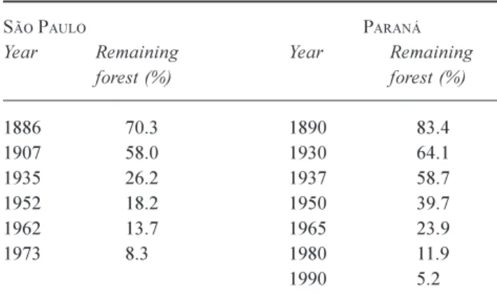
Table 2 shows the rate of deforestation in just two Brazilian States, São Paulo and Paraná, whose areas mostly drain to
Table 1. Characteristics of drainage basins of the South American
sub-continent.
River Drainage area Mean annual flow (106 km2) (m3s-1) Amazon 6.0 118900 la Plata 3.1 21400 Tocantins-Araguaia 0.9 13600 São Francisco 0.6 2850 Orinoco 0.9 34800 Thames (Teddington) 0.0099 53 Rhine 0.185 2200
Hydrological prediction in a non-stationary world
the la Plata catchment area. The changes in land use are almost certainly permanent, consisting of substitution of native forest by agriculture, cattle-ranching and rapid urban development.
Climate fluctuation over the South
American sub-continent
Much has been written about fluctuations and apparent trends in South American climate (Ropelewski and Halpert, 1987, 1989, 1996; Aceituno, 1988; Pisciottano et al., 1994; Diaz et al. 1998; Garcia and Vargas, 1997; Mechoso and Perez-Ibarren, 1992), and one of the most persuasive ways of demonstrating such changes is through the flow regimes of rivers which have remained largely uninfluenced by the land-use changes mentioned above, and which have not been impounded for hydropower generation. One such river is the Upper Paraguay which flows southwards to join the Paraná; their combined flow continues south-eastwards to join the third major tributary of the la Plata system, the River Uruguay. Figure 1 shows the Upper Paraguay, together with the Pantanal, the worlds largest wetland which, depending on season, can extend up to 145 000 km2. During the period Table 2. Deforestation in the Brazilian States of São Paulo and
Paraná: percentage of original forest cover remaining.
SÃO PAULO PARANÁ
Year Remaining Year Remaining forest (%) forest (%) 1886 70.3 1890 83.4 1907 58.0 1930 64.1 1935 26.2 1937 58.7 195218.2 1950 39.7 196213.7 1965 23.9 1973 8.3 1980 11.9 1990 5.2
from about 1960 to the early 1970s, seasonal flooding in the Pantanal diminished very substantially, and this is demonstrated in the hydrographs of mean annual discharge shown in Figs. 2, 3 and 4. Land that had formerly been flooded was opened up for ranching, and considerable investment was lost when, a decade or so later, floods returned to normal levels. If such an extended period of drought occurred again, and in particular if it affected the adjacent basin of the Upper Paraná which has been developed extensively for hydropower production, consequences for the Brazilian economy would be grave
indeed. The hydropower installation at Itaipú, mentioned above, was also designed using flow records up to 1970, after which flows appeared to increase very substantially; Müller et al.(1998) found that mean annual inflows to Itaipú during the period of record after 1970 was 36% higher than that of the period before, from a drainage area of 820 000 km2. For a further 31 hydropower installations upstream of
Itaipú, the ratio of mean annual discharges post-1970 to before-1970, was 1.17 ± 0.024.The standard error is probably underestimated because it takes no account of spatial correlation between gauging stations, but the authors
19300 1940 1950 1960 1970 1980 1990 2000 2010 1000 2000 3000 4000 5000 Year Me a n a n n u al fl o w, c u me c s
R. Paraguai at Porto Murtinho
19000 1920 1940 1960 1980 2000 2020 100 200 300 400 500 Year Me a n a n n u al le v el, c m R. Paraguai at Ladario
Fig. 2. Records from two stations on the Upper Paraguay, Porto Murtinho and Ladário, showing the period of low flow from about 1960 to the
early 1970s. (Note: because the Ladário record is longer, horizontal scales are different in the two figures).
1960 1965 1970 1975 1980 1985 1990 1995 2000 2005 200 400 600 800 Me a n a n n u al fl o w, c u me c s R. Paraguai at Caceres 19600 1965 1970 1975 1980 1985 1990 1995 2000 2005 200 400 600 800 Year Me a n a n n u al fl o w, c u me c s R. Cuiaba at Cuiaba
Fig. 3. Records from two stations on the Upper Paraguay, Cáceres and Cuiabá, showing the period of low flow from about 1960 to the early
Hydrological prediction in a non-stationary world
report that the ratio increases with distance downstream. Müller et al.(1998) also reported results of rainfall analyses: the ratio of mean annual rainfall after 1970 to mean annual rainfall before 1970, for 40 raingauges in the State of Paraná, was 1.124 ±0.0198, and for 61 gauges in the State of São Paulo, 1.198 ±0.0113. For three contributing sub-basins of the Paraná system (Rio Grande, Rio Tietê and Rio Paranapanema), and for the incremental drainage area downstream of the Paranapanema and upstream of the Itaipú hydropower installation, mean annual rainfalls before and after 1970 were as shown in Table 3. There is strong evidence that the rainfall regime in the two periods is different. These results are substantiated by other research; Robertson and Mechoso (1998) analysed flows in four rivers of south-eastern South America ( the Negro, Paraguay, Paraná and Uruguay) for the period 191193, and found significant evidence of (i) a non-linear trend; (ii) a near-decadal
component, and (iii) interannual peaks with ENSO timescales. On interannual timescales, precipitation in this south-eastern region has also been found to be related to ENSO (Ropelewski and Halpert, 1987, 1989, 1996; Aceituno, 1988; Pisciottano et al., 1994; Diaz et al. 1998).
Consequences of climate fluctuation
for hydrological practice
Many of the computational procedures in current hydrological use assume that past values of annual totals, means and extreme values of hydrological variables vary about a constant mean value, with constant variance and constant serial correlation structure. Examples of such procedures are (i) the calculation of discharge with T-year return period; (ii) calculation of rainfall intensityduration frequency curves used in urban drainage design; (iii) regionalisation of precipitation and runoff data, by correlation with characteristics of catchment topography, climate and soils; (iv) stochastic simulation of water-resource systems, in which inflows to reservoirs are modelled to include correlation within and between flow sequences. Experience suggests, however, that the assumptions of constant mean, variance and correlation structure in annual totals, means and extreme values of hydrological variables are invalid, at least under some South American conditions. The term non-stationarity is a convenient way of describing characteristics of hydrological series which do not meet the constancy criteria referred to Fig. 4. Records from Coxim on the Upper Paraguay, and Porto de Cima on the R. Manso, showing the period of low flow from about 1960 to
the early 1970s. 1960 1965 1970 1975 1980 1985 1990 1995 2000 2005 100 200 300 400 500 Year Me a n a n n u al fl o w, c u me c s R. Paraguai at Coxim 19300 1940 1950 1960 1970 1980 1990 2000 1000 2000 3000 4000 Year Me a n a n n u al fl o w, c u me c s
R. Manso at Porto de Cima
Table 3. Mean annual rainfall (mm) 1936-70, and 1971-90, for
three sub-basins draining to the River Paraná, and incremental drainage area above Itaipú.
Basin Mean, 193670 Mean, 197190
R. Grande 1310 ± 35 1538 ± 56 R. Tietê 1253 ± 32 1446 ± 56 R. Paranapanema 1294 ± 44 1504 ± 53 Incremental 1542 ± 44 1690 ± 64
above, but the term is over-simplistic in that it fails to distinguish between long-term fluctuations (such as those caused by slowly-varying climate) and gradual changes from one steady state to another (such as those occurring where mature forest is replaced by short crops over a period of decades). The adaptation of existing hydrological procedures to allow for such non-stationarity represents a major challenge for hydrologists. With regard to flow in rivers, the challenge has two components: the first is how to separate out the effects of land-use change from other factors causing year-to-year variability in runoff, and the second is to establish which climatic factors cause slow variations in climate, and how they function. This second component requires very close collaboration between hydrologists, meteorologists and climatologists, and a rethink about well-established concepts such as return period. Very possibly, the next 30 years will witness reduced research emphasis on within-catchment, short-term hydrological process studies, and greater emphasis on longer-term atmosphere-surface processes.
Conclusion
The period since the seminar A view from the watershed was held at Wallingford has been one of growing understanding of what happens to rain when it reaches the catchment surface. The emphasis of the next few decades should be to clarify the processes causing slow variations in climate and climate variability, both for the purpose of forecasting how slow changes will develop, and for predicting the frequency of occurrence of events of specified magnitude.
References
Aceituno, P., 1988. On the functioning of the Southern Oscillation in the South American sector. Part I: Surface climate. Mon.
Weather Rev., 116, 505524.
Beran, J., 1994. Statistics for long-memory processes. Chapman & Hall/CRC, London, UK.
Diaz, A.F., Studzinski, C.D. and Mechoso, C.R., 1998. Relationships between precipitation anomalies in Uruguay and Southern Brazil and sea surface temperatures in the Pacific and Atlantic Oceans. J. Climate, 11, 251271.
Fortey, R., 2004. The Earth: an intimate history. Harper Collins, London, UK.
Garcia, N.O. and Vargas, W., 1997. The temporal climatic variability in the Rio de la Plata basin displayed by river discharges. Climate Change, 102, 929945.
Hurst, H.E, Black, R.P. and Simaika, Y.M., 1965. Long-term
storage. Constable, London, UK..
IPCC, 2001. http://www.grida.no/climate/ipcc_tar/wg2/ 011.htm#31
Klemes, V., 1974. The Hurst phenomenon: a puzzle? Water Resour.
Res., 10, 675688.
Lloyd, E.H., 1967. Stochastic reservoir theory. Adv. Hydrosci., 4, 281.
Mandelbrot, B.B., 1977. Fractals: form, chance and dimension. Freeman, San Francisco, USA.
Mandelbrot, B.B., 1983. The fractal geometry of nature. Freeman, San Francisco, USA.
Mandelbrot, B.B. and Wallis, J.R., 1968a. Noah, Joseph and operational hydrology. Water Resour. Res., 4, 909918. Mandelbrot, B.B. and Wallis, J.R., 1968b. Robustness of the
rescaled range R/S and the measurement of non-cyclic long-run statistical dependence. Water Resour. Res., 5, 967988. Mandelbrot, B.B. and van Ness, J.W., 1968. Fractional Brownian
motions, fractional noises and applications. SIAM Rev., 10, 422 437.
Mechoso, C.R. and Perrez-Iribarren, G., 1992. Streamflow in southeastern South America and the Southern Oscillation. J.
Climate, 5, 15351539.
Müller, I.I., Krüger, C.M. and Kaviski, E., 1998. Analysis of stationarity in hydrological series in the incremental basin of Itaipú (in Portuguese) Revista Brasileira de Recursos Hídricos 3,4 Oct/Dec., 5171.
Pisciottano, G., Diaz, A., Cazes, G. and Mechoso, C.R., 1994. El-Niño-Southern Oscillation impact on rainfall in Uruguay. J.
Climate, 7, 12861302.
Robertson, A.W. and Mechoso, C.R., 1998. Interannual and decadal cycles in river flows of southeastern South America. J.
Climate, 11, 25702581.
Ropelewski, C.F. and Halpert, M.S., 1987. Global and regional scale precipitation patterns associated with the El Niño/Southern Oscillation. Mon. Weather Rev., 115, 16061626.
Ropelewski, C.F. and Halpert, M.S., 1989. Precipitation patterns associated with the high index phase of the Southern Oscillation.
J. Climate, 2, 268284.
Ropelewski, C.F. and Halpert, M.S., 1996. Quantifying Southern Oscillation relationships. J. Climate, 9, 10431059.