HAL Id: hal-00299435
https://hal.archives-ouvertes.fr/hal-00299435
Submitted on 14 Jun 2007
HAL is a multi-disciplinary open access
archive for the deposit and dissemination of
sci-entific research documents, whether they are
pub-lished or not. The documents may come from
teaching and research institutions in France or
abroad, or from public or private research centers.
L’archive ouverte pluridisciplinaire HAL, est
destinée au dépôt et à la diffusion de documents
scientifiques de niveau recherche, publiés ou non,
émanant des établissements d’enseignement et de
recherche français ou étrangers, des laboratoires
publics ou privés.
(Italy) for studying possible geochemical precursory
phenomena
R. Cioni, M. Guidi, L. Pierotti, A. Scozzari
To cite this version:
R. Cioni, M. Guidi, L. Pierotti, A. Scozzari. An automatic monitoring network installed in Tuscany
(Italy) for studying possible geochemical precursory phenomena. Natural Hazards and Earth System
Science, Copernicus Publications on behalf of the European Geosciences Union, 2007, 7 (3),
pp.405-416. �hal-00299435�
www.nat-hazards-earth-syst-sci.net/7/405/2007/ © Author(s) 2007. This work is licensed under a Creative Commons License.
and Earth
System Sciences
An automatic monitoring network installed in Tuscany (Italy) for
studying possible geochemical precursory phenomena
R. Cioni, M. Guidi, L. Pierotti, and A. Scozzari
CNR Institute of Geoscience and Earth Resources, Pisa, Italy
Received: 18 July 2006 – Revised: 27 November 2006 – Accepted: 30 May 2007 – Published: 14 June 2007
Abstract. Since late 2002, a continuous automatic
moni-toring network (CAMN) was designed, built and installed in Tuscany (Italy), in order to investigate and define the geo-chemical response of the aquifers to the local seismic activ-ity. The purpose of the investigation was to identify even-tual earthquake precursors. The CAMN is constituted by two groups of five measurement stations each. A first group has been installed in the Serchio and Magra graben (Garfag-nana and Lunigiana Valleys, Northern Tuscany), while the second one, in the area of Mt. Amiata (Southern Tuscany), an extinct volcano. The measured parameters are: T, pH, Eh, EC, dissolved CO2and CH4. The results of three years
of continuous monitoring can be summarised as follows: i) the monitoring stations made it possible to detect even small variations of the measured parameters, with respect to equiv-alent commercial devices; ii) acquired data made it possi-ble to identify the groundwater circulation patterns; iii) in most locations, the observed trend of the acquired parame-ters is consistent with the periodic manual sampling results, and confirms the mixture of different water types that the hy-drogeochemical model has determined.
The absence of seismic events with a sufficient energy precluded the possibility to locate anomalies, with the only exception of the Equi Terme site, where an increase in the dissolved CO2 content was observed twelve days before a
M=3.7 earthquake occurred at a distance of 3 km north of the monitoring station.
The CAMN resulted as being a suitable tool in order to in-vestigate the anomalous variations of the physical, physico-chemical and physico-chemical parameters of aquifer systems as earthquake precursors.
Correspondence to: A. Scozzari
1 Introduction
The study of the earthquake precursory phenomena has at-tracted the interest of the scientific community for quite some time (Wakita et al., 1975; King, 1986, 1989; Thomas, 1988; Johansen et al., 1996; Wyss, 1997; Quattrocchi et al., 1999; Toutain and Baubron, 1999; Biagi et al., 2000; Johansen et al., 2000 Zanzari et al., 2001; Carapezza et al., 2005; Hart-mann et al., 2006; Pulinets et al., 2007; Singh et al., 2007 and references therein); nevertheless, the problem of earthquake prediction has yet to be solved.
The consideration that stress field variation can determine permeability and porosity changes in the rocks and can mod-ify the fluid flows from deep systems, has driven the choice of the more significant parameters to be examined by geo-chemical monitoring programs. Most of the literature data comes from the study of hydrothermal systems although cold and shallow aquifers have also been taken into consideration. Such studies have revealed significant modifications of phys-ical and physico-chemphys-ical parameters (such as electrphys-ical con-ductivity, T, pH, Eh), and the concentration of dissolved ionic species and gases (CO2, H2, Rn, He, CH4) in the waters in
connection with strong earthquakes.
The development of geochemical monitoring methods and devices increased after the Tashkent (Uzbekistan) earthquake of 1966, that produced the first well documented Radon anomaly (Ulomov and Mavashev, 1967).
During the last two decades, an increasing interest in searching the geochemical precursors of earthquakes has also been observed in Italy (Bencini et al., 1990; Quattrocchi and Calcara, 1998; Garavaglia et al., 1999; Nucci et al., 2005; Quattrocchi et al., 1999; Cioni and Guidi, 2001; Zanzari et al., 2001 and references therein). In particular, IGG-CNR, PI has been involved in the development of various instru-mental prototypes for the automatic measurement, of various parameters such as: i) the gas/vapour ratio and the concentra-tions of H2, CH4and CO in the fumarolic fluids (magmatic
K & ! / * & + ,!
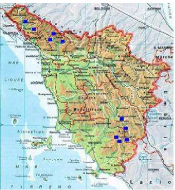
Fig. 1. The monitoring network.
and geothermal) and soil gases (Cioni et al., 1999; Cioni and Guidi, 2001); ii) the soil CO2 flux (Chiodini et al., 1996)
and iii) T, pH, Eh, CE, CO2, CH4 in thermal water
(Zan-zari et al., 2001). The individuation of such precursors is the main objective of initiatives like the MICRAT project (Zan-zari et al., 2001) that has been programmed after the violent 1997 Colfiorito earthquakes (M=5.8), Umbria, Italy. In that project, the automatic stations for the continuous monitor-ing of physical, physico-chemical and chemical parameters in waters of selected springs and wells are the same as those (with minimal changes) used in the work reported here.
The collection of good quality data series, with meaning-ful time coverage, is an essential step to drive the research regarding precursors to tangible results for the earthquake prediction. The precursory information can be derived from the identification of pre-seismic alterations and their subse-quent validation through suitable data processing. A high-resolution assessment strategy (both in time and in space), which could improve the existing methods of earthquake haz-ard assessment, may come from merging the experiences re-lating to the many aspects of the assessment process, such as modelling and individuation of relevant parameters, design and management of the monitoring networks (both manned and automatic), data processing and interpretation steps.
This paper describes the continuous automatic monitoring network (CAMN) designed, built and installed in Tuscany (Italy), for measuring physical, physico-chemical and chem-ical parameters in natural water. The network is constituted by two groups of five measurement stations each. They were
installed in late 2002 in Garfagnana/Lunigiana area (N-W Tuscany) and in the area of Mt. Amiata, Southern Tuscany (Fig. 1).
2 Seismotectonic framework
Garfagnana, Lunigiana and Mt. Amiata regions belong to the inner zone of the Northern Apennine fold-and-thrust belt. This zone has been involved in the post-collision extensional tectonics since the Upper Miocene-Pliocene.
Such tectonic activity has produced horst and graben struc-tures oriented from N-S to NW-SE that are transferred by NE-SW system (Carmignani et al., 1994; Jolivet et al., 1998). Both Garfagnana (Serchio graben) and Lunigiana (Magra graben) belong to the most inner sector of the belt where the seismic sources, responsible for the strongest earthquakes of the northern Apennine, are located (e.g. the M=6.5 earth-quake of September 1920).
The extensional processes in southern Tuscany have been accompanied by magmatic activity since the Up-per Miocene, developing effusive and intrusive products traditionally attributed to the so-called Tuscan Magmatic Province (Marinelli, 1967; Serri et al., 1993; Peccerillo, 1999). Mt. Amiata, whose magmatic activity ceased about 0.3 M.y. ago, belongs to the extensive Tyrrhenian sector (Meletti and Valensise, 2004) that is characterized by high heat flow and crustal thinning. The whole zone is charac-terized by wide-spread but moderate seismicity (the maxi-mum recorded magnitude has been 5.1 with epicentre in Pi-ancastagnaio, 1919).
The extensional regime in both the Garfagnana-Lunigiana and Mt. Amiata area is confirmed by the focal mechanisms of recent earthquakes (Frepoli-Amato, 1997; Rosini et al., 1997; Frepoli-Amato, 2000).
An essential phase of the monitoring activities has been the selection of suitable sites for the installation of moni-toring stations. This has been carried out on the basis of: i) hydrogeologic and structural studies in order to assess the underground fluid circulation regime; ii) a detailed geochem-ical study of all the natural manifestations present in the se-lected territories, such as cold and hot springs and gas emis-sion zones; iii) logistical aspects.
3 Selection of the installation sites
The Serchio Valley and the adjacent north-western sector of the Apuan have been well studied. Numerous thermal springs are present in these areas, most of which are emerg-ing in correspondence to the main neotectonic structures of the region (De Stefani, 1904; Pieri and Burichetti, 1930; Masini, 1956; Francalanci, 1956; Masini, 1964; Trevisa et al., 1971; Bencini et al., 1977; Fancelli and Agostini, 1980; Baldacci and Raggi, 1982; Baldacci et al., 1993; Fanelli et al., 1982; Calvi et al., 1999; Boschetti et al., 2005). These
springs are fed by a regional circulation developing in a Mesozoic evaporite carbonate reservoir. The base of this aquifer comprises quartzites, quartzitic-micaceous conglom-erates and sandstones, and Palaeozoic phyllites, while, in the Apennine sector, the top comprises the Oligocene shale and sandstone.
The main feeding areas of the deep reservoir are located in the extended carbonate outcrops of the Apuan Alps and the limited carbonate outcrops (Lima valley, Corfino and Sorag-gio) in the Apennine sector of the Serchio Valley.
With regard to the Magra Valley, in spite of the struc-tural analogies with the Serchio Valley (both are semi-graben structures, Eva et al., 1978), some important hydrogeologi-cal features are not present. For example, in this region no important hydrothermal manifestations are present, perhaps due to the absence of recharge areas (both as to extension and piezometric gradient) of a possible deep reservoir (Baldacci and Raggi, 1982). Therefore, a detailed hydrogeochemical study was performed in 2002. A total of 150 water points were sampled and analysed. Moreover, more accurate hydro-geological and hydrogeochemical studies were performed in the Bagni di Lucca area in order to locate optimal sites for monitoring. This work has been necessary due to the high number of thermal springs present in the area. Based on the results of this multidisciplinary study, five water points suitable for the installation of the monitoring stations, were selected. They are: Bagni di Lucca (Bernab`o spring), Galli-cano (Capriz spring) and Pieve Fosciana (Pr`a di Lama spring) in Garfagnana, Equi Terme (main spring feeding the swim-ming pool of the thermal resort) and Villafranca in Lunigiana (well feeding the public swimming pool).
The Amiata area is characterized by two regional aquifers. The first is composed of volcanic rocks extending over an area of approximately 81 km2while the second one is con-nected to the Mesozoic evaporite carbonate rocks and is fed by meteoric waters.
The latter is a confined aquifer, sandwiched between a Pa-leozoic basement (bottom) of low permeability, and the im-permeable rock of Ligurian Units and neogene peliti (top) (Calamai et al., 1970; Duchi et al., 1992). The recharge area is composed of the carbonate rocks emerging in the highland east of Mt Amiata (Fancelli and Nuti, 1975; Celati et al., 1990).
In the preliminary campaign, 69 water points were sam-pled and analyzed and five sites were selected. They are: Piancastagnaio, Santa Fiora, Pian dei Renai and Bagnore, which are fed by the volcanic aquifer, and Bagno Vignoni borehole, which is fed by the evaporite carbonate aquifer.
The installation and start-up process of the monitoring sys-tems in the Garfagnana-Lunigiana area begun in November 2002; in the Monte Amiata region it begun in June 2003.
From the day of installation, a periodic water sampling and manual measurement of the main physical and physico-chemical parameters have been carried out on a monthly ba-sis. Such activity has the double function of performing a
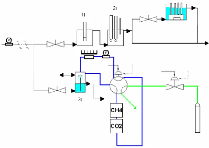
Fig. 2. Block diagram of the fluid measurement chain.
cross-check of the monitoring instrumentation, and carrying out additional chemical and isotopic analysis.
4 The monitoring equipment installed in Tuscany
All the stations of the monitoring network (Fig. 1) have a common architecture (Table 1) and record the following pa-rameters: temperature (T), pH, electrical conductivity (EC), redox potential (ORP) and the content of CO2and CH4
dis-solved in water. Particular attention has been devoted to the determination of the dissolved CO2content.
Each monitoring station can be divided into two sections (see Fig. 2), which are almost completely separated, even physically wise: one dedicated to the traditional physico-chemical water parameters, the other to the concentration of dissolved gases.
The station operates with flowing water (about 5 litres per minute). The sampled water, naturally flowing (spring) or drawn from a well by a submersible pump, is split into two separate paths for the two sections mentioned above. For the physico-chemical parameters, there are two consecutive cells where conductivity (first cell), T, pH and ORP (second cell) are respectively measured. Dissolved gases are mea-sured with a third cell, which belongs to the separate path.
In cell 3 (see Figs. 3a and 3b), gas is equilibrated by flow-ing in the headspace above the water level inside the cell, in a closed loop which includes the I.R. spectrometers and a low-flow pump, which provides the necessary gas circulation in the loop. The system is calibrated using an external standard gas supply. A six-way valve is configured to ensure that the measurement loop is never broken, neither during the cali-bration procedure, nor during the regular measurement. A solenoid valve is added to cut off the standard gas while the system is in the measurement configuration.
The submersible pumps have been chosen to withstand the temperature and the chemical aggressiveness that the water
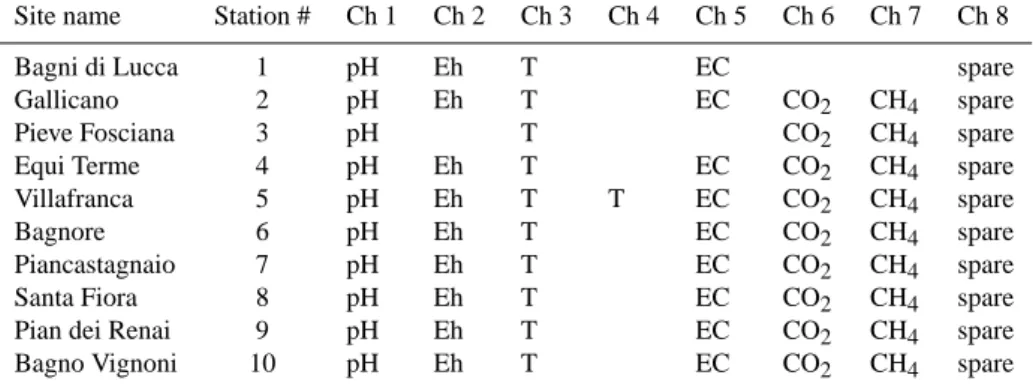
Table 1. The monitoring network.
Site name Station # Ch 1 Ch 2 Ch 3 Ch 4 Ch 5 Ch 6 Ch 7 Ch 8 Bagni di Lucca 1 pH Eh T EC spare Gallicano 2 pH Eh T EC CO2 CH4 spare
Pieve Fosciana 3 pH T CO2 CH4 spare
Equi Terme 4 pH Eh T EC CO2 CH4 spare Villafranca 5 pH Eh T T EC CO2 CH4 spare
Bagnore 6 pH Eh T EC CO2 CH4 spare
Piancastagnaio 7 pH Eh T EC CO2 CH4 spare
Santa Fiora 8 pH Eh T EC CO2 CH4 spare
Pian dei Renai 9 pH Eh T EC CO2 CH4 spare
Bagno Vignoni 10 pH Eh T EC CO2 CH4 spare
. K & 9! / & !
Fig. 3. The gas cell.
exhibits in some of the installation sites; wet parts of the pumps are made of a plastic self-lubricating material able to run at temperatures up to 90◦C. In addition a suitable deliv-ery/head curve has been selected to obtain the required wa-ter flow without self-heating issues for both the motor and the pump, which would cause the transfer of heat to the wa-ter. Moreover, water adduction tubes and cells are thermally insulated to reduce the heat loss to the environment, which would lower the temperature of the sampled water.
As to the electronics, a simplified block diagram is re-ported in Fig. 4. All the signals are isolated (galvanic iso-lation via transformer) and conditioned with a fifth-order low-pass filter having a high DC accuracy, according to the slowness (speed) of the measurements acquired. Signals come from the sensors to the signal conditioning block ei-ther directly or via some analog front-end. As to the high-impedance electrodes (pH and ORP measurement), a differ-ential electrometer (an amplifier with a very low input current loss) has been custom designed to meet high specifications exceeding the usual market availability. The electrometer provides three-port isolation and operates over a wide tem-perature range; in particular, care has been taken to minimise the effect of ambient temperature drifts on the measurement of pH.
Fig. 4. Simplified block diagram of the apparatus.
Table 2 shows the essential specifications of the measure-ment chain for each channel; as for the pH and ORP mea-surements, accuracy is intended to be the maximum devia-tion from the room temperature calibradevia-tion over the whole working temperature range (−20◦. . .+70◦C).
The core of the data-logging system is a Personal Com-puter in PC/104 format, which runs a program that controls all the activities of the station via the onboard serial ports. An RS485 port is used to communicate with the data conversion devices, which perform all the input/output processes. One of the two devices (A/D) performs the multiplexing and the analog-to-digital conversion of the input channels; the other one (DIG) manages the digital input/output signals to control the solenoid valves, to switch on the modem, and to check the mains power line and the state of the batteries.
Data can be downloaded both onsite and in remote, via a GSM/GPRS modem connected to the embedded PC. The remote link also makes it possible to see real-time values for all the parameters and to interact with the machine in order to check and modify its internal parameters, in addition to the pure download feature.
Table 2. Characteristics of the sensors.
Parameter Sensor Analytical range Accuracy pH HA405-DXK-S8/120 combination Xerolit glass
elec-trode (Ag/AgCl reference)
2÷14 pH <0.03 pH
Eh Pt4805-DXK-S8/120 combination platinum electrode −1250÷1250 mV <1.5 mV
Conductivity Hanna HT8936 four electrode configuration (platinum rings)
0÷19.99 mS·cm−1 <2% of range
Temperature PT100 (class A according to BS1904 standard) 0÷100◦C <0.15◦C at 0◦C Carbon dioxide IR cell 0÷10% 0÷100% <2% of range
Methane IR cell 0÷10% <2% of range
Fig. 5. Block diagram of the gas measurement section.
Data are acquired once per second; the average value, me-dian value and variance of the samples collected over a pe-riod of 5 min are recorded in a local removable non-volatile memory (Compact Flash card).
Both the solenoid valve and the six-way valve reported in Fig. 5 (the latter of which is actually simulated by means of four three-way solenoid valves) are driven by the embedded PC to perform a daily calibration, during which time the cut-off valve is opened and the six way valve is switched, making the standard gas enter into the measurement loop.
It is imperative that liquid water from condensation does not reach the optical measurement cells, as this would induce major errors and eventually damage the optical cells. To ad-dress this issue, the gas temperature is lowered below the minimum expected temperature within the cells with a heat exchanger based on a Peltier element (solid state heat pump), and the condensate is separated. In this way, pre-conditioned dry gas is sent to the cells.
The software that runs on the embedded PC installed in each measurement station has been custom-designed for the specific application. It consists in a data logger application that manages all of the analog and digital signals which are
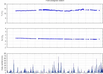
Fig. 6. Continuous monitoring at the Piancastagnaio station. The
rainfall data have been recorded at the Castel del Piano station.
fed into the device, plus the communication protocol, the ibration process, the local database management and the cal-culation of the statistics about collected data. Data are trans-mitted in a packed binary compact form to allow for remote storage and post-processing at IGG headquarters in Pisa. Ad-ditional filtering, such as moving window or median filtering, as well as eventual subsampling, usually down to a rate of one sample/hour is carried out before any other processing.
Data series obtained by such signal conditioning processes are then studied with traditional multivariate analyses tech-niques.
5 Results
Some of the monitored locations show relatively large varia-tions of the observed parameters that are generally explained by natural mixing processes between different water types. The different degree of mixing, due to several factors such as rainfall, can make the interpretation of data relating to the presence of eventual precursors generally difficult. Thus, in the case of signal processing, one of the most challenging
K & :! * & " K ! / 0 .
Fig. 7. Continuous monitoring at the Santa Fiora station. The
rain-fall data have been recorded at the Castel del Piano station.
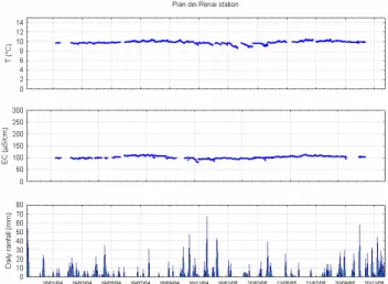
Fig. 8. Continuous monitoring at the Pian dei Renai station. The
rainfall data have been recorded at the Castel del Piano station.
activities lies in the extraction of features from the collected data series, that are relevant to the detection of eventual pre-cursors, selected to have the lowest possible sensitivity from unwanted contributions such as meteorological parameters, looking for the evidence of deep effects on the mixing pro-cesses.
In the large dataset collected (10 monitoring devices with 8 channels each, recording data every 5 min since year 2003) there are many situations in which the time series are clearly affected by the influence of unwanted factors, such as the abovementioned rainfall. On the other hand, the absence of seismic events with sufficient energy precluded the possibil-ity of locating anomalies, with only one exception up to now. In fact, only at the monitoring station located in Equi Terme was there an increase in the CO2value, which was
ob-served twelve days before a M=3.7 earthquake that occurred
Fig. 9. Continuous monitoring at the Bagnore station. The rainfall
data have been recorded at the Castel del Piano station.
at a distance of 3 km north of the installation site. The re-lationship between the dissolved CO2concentration and the
other water physical parameters collected under this circum-stance, may be seen as a precursory signal as discussed fur-ther in this paper.
5.1 An overview of the collected data
The spring waters of Piancastagnaio, Santa Fiora and Pian dei Renai (Figs. 6, 7, 8), that are fed by the aquifer developed in volcanic rocks of Mt. Amiata, belong to the Ca-HCO3
wa-ter type. They show temperatures ranging between 10◦C and 13◦C, and a very low TDS content (from 70 to 75 mg/l), with quite a low maturity degree.
The Ca-SO4 spring water of Bagnore has a positive Eh
value (average +306 mV) with a temperature of 21.5◦C. Its salinity is low (240 mg/l), while the CO2 concentration in
dissolved gases is about 3.6%. For this spring, which is also fed by the volcanic rocks of Mt. Amiata, the analyti-cal data indicate some contamination by geothermal fluids rich in CO2, H2S and H3BO3. Although the time-series
analysis (Fig. 9) indicates that the Bagnore spring water is clearly influenced by local rain, the evidence of contami-nation by geothermal fluids indicates the site as particularly suitable to detect those eventual deep variations of the physi-cal, physico-chemical and chemical parameters that can pre-cede an earthquake.
The water of the Bagno Vignoni shallow borehole belongs to the Ca-SO4 type. It has a negative Eh value (average −106 mV) and shows a mean temperature of 48.4◦C. The TDS is quite constant at around 3.9 g/l while the CO2partial
Fig. 10. Continuous monitoring at the Bagno Vignoni station. The
rainfall data have been recorded at the Castel del Piano station.
Fig. 11. Continuous monitoring at the Pieve Fosciana station. The
rainfall data have been recorded at the Villa Collemandina station.
pressure approximates 1 bar. This water, that is representa-tive of deep circulation in a Mesozoic evaporite carbonate reservoir, displays very constant physical and chemical char-acteristics over time (Fig. 10). No influence by local rain, or mixing processes with other deeper circulation water types has been observed. Therefore it appears to be very favourable for recognizing anomalous input of different fluids connected to the processes of seismic energy accumulation.
As far as the Garfagnana and Lunigiana areas are con-cerned, the Pieve Fosciana water belongs to the Na-Cl type, whit a a stable temperature of 36.5◦C and a TDS of 5.9 g/l,
while CO2concentration in dissolved gases is 7.5%.
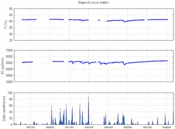
Bernab`o spring water (Bagni di Lucca) belongs to Ca-SO4
type. It shows a temperature of 40.5◦C and a salinity of about 2.5 g/l.
Fig. 12. Continuous monitoring at the Bagni di Lucca station. The
rainfall data have been recorded at the Bagni di Lucca station.
Fig. 13. Continuous monitoring at the Gallicano station. The
rain-fall data have been recorded at the Careggine station.
Both Pieve Fosciana and Bagni di Lucca emergences are artesian springs. They rise in the Apennine sector of the Serchio graben where the Oligocenic shales and sandstones, which represent quite an impermeable cover, outcrop abun-dantly. For this reason, the chemical and physico-chemical characteristics acquired by the water in the deep aquifer are maintained during their ascent to the surface (Figs. 11 and 12).
Gallicano spring water belongs to the Na-Ca-Cl water type. It has a positive Eh value (average +365 mV) while the water temperature ranges from 23.7◦C (June 2004) and 24.9◦C (October 2003). Its TDS ranges from 3.1 to 3.9 g/l,
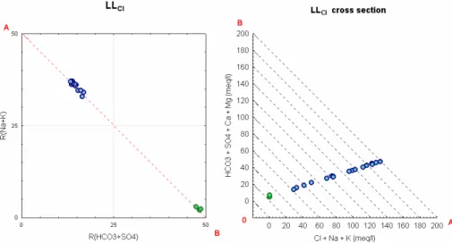
Fig. 14. LLCl square diagram and LLClcross section (Langelier and Ludwig, 1942) for Equi spring waters (blue circles) and for karst
shallow spring waters sampled in the Equi hydrogeologic basin (green circles).
! " " " "! #$ " " "!
Fig. 15. Variation in time of T and TDS compared with monthly
rainfall.
while the CO2 concentration in dissolved gases is around
2.5% (Fig. 13). The Gallicano emergence is a contact spring that rises in the Apuan sector of the Serchio graben where the carbonate rocks outcrop abundantly. For this spring, mix-ing processes between a deep component (a mixture of two different deep-water-types) and a shallow groundwater, have been recognized. The deep component rises along the NW-SE normal fault at the eastern edge of the Apuan Alps, while the shallow component is a diluted Ca-bicarbonate water.
The Villafranca well water belongs to the Ca-HCO3water
type. It has a negative Eh value (average −200 mV) and a temperature of 15.4◦C. Its salinity is low (235 mg/l), while the CO2concentration in dissolved gases is about 0.15%.
The Equi Terme spring emerges along the north-western edge of the carbonate outcrops of the Apuan Alps. Specifi-cally, the spring is located along the NE-SW transfer system between the Magra graben and the Serchio graben. Here, ris-ing thermal water mixes with superficial karst water; more details will be given in the next paragraph.
5.2 A case study: the Equi Terme site
The Equi Terme monitoring station was installed in 2003 (21 September) at the main spring (Q=100=l/s) that feeds the thermal resort and the thermal swimming-pool. Between February 2003 and August 2004, the Equi Terme spring was also sampled monthly for hydrogeochemical and iso-topic analyses. All samples belong to the Na-Cl water type (Fig. 14) and their TDS ranges from 1.2 to 5.5 g/l (Fig. 15). The temperature values lie in the interval between 17.8◦C (March 2003) and 26.2◦C (September 2003).
Analysed samples have shown that the Equi Terme water originates from a mixing, at a different degrees, of karst shal-low Ca-HCO3water and deep Na-Cl water (Fig. 14). Their
mixing ratio depends mainly on the effect of the rainwa-ter that recharges the karst superficial circulation, as seen in Fig. 15.
Hydrogeochemical and isotopic data, associated with the time series of all the parameters acquired by the monitoring equipment, together with the structural and hydrogeological context, allow us to define a conceptual model of groundwa-ter flow.
The recharge area of deep water circulation that feeds the Equi Terme spring is located in the carbonate rocks out-cropping in the northern sector of Apuan Alps: the under-ground circulation, guided by metamorphic basement, fol-lows a northerly direction. The rise of deep thermal water, after having deeply interacted with Triassic marine evapor-ites of the “Tuscan series”, occurs along low and high-angle fault systems, located at the northern edge of Apuane Alps. Such rising water comes into contact with the cold iposaline water of the shallow circulation, recharged by the local rain water. Rainfall influences all the measured parameters, in-cluding the CO2concentration (Fig. 16).
K & A! * & 1 ! / 0 . !
Fig. 16. Continuous monitoring at Equi station. The rainfall data
have been recorded at the Aulla station.
K & :! 6 0 ! / 6 0 ! 8 * 0 )=H)(H)7 R ()H)=H)7!
Fig. 17. CO2vs. T and CO2vs. EC scatterplot; time interval: 9
February 2004–20 September 2004.
In the middle of August 2004, a sharp increase in CO2
value in the dissolved gas, apparently uncorrelated with T and EC (Fig. 17) neither with the rainfall trend (Fig. 16), was detected.
This was the only exception in the monitoring period dis-cussed here (between September 2003 and June 2005), since the acquired signals were always distinguished by a high de-gree of correlation between T, EC and CO2values.
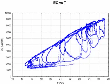
Fig. 18. EC vs. T scatterplot; time interval: 21 September 2003–4
June 2005.
Fig. 19. CO2vs. T and CO2vs. EC scatterplot; time interval: 9
February 2004–4 June 2005.
In addition, such a correlation is characterised by a no-ticeable time delay (rainfall-dependant), which leads to trace regular orbits in the EC-T (Fig. 18) and CO2-T domains
(Fig. 19). Moreover, the fact that the effect of a variation in the mixing ratio on the chemical-physical parameters is faster than the effect over the temperature, leads to larger orbits in the scatterplots involving T than in the one repre-senting the CO2-EC. This is an expected behaviour due to
the thermal capacity of the system where such mixing hap-pens, which delays every effect over the temperature. Such particular features represent a good opportunity for studying techniques for removing unwanted correlations between in-formative parameters and sources of perturbation, in order to better select meaningful anomalies. In fact, the isolated lack of correlation found in the CO2-T and CO2-EC scatterplots
(see the red arrows in Fig. 19) appears to be informative: it suggests that there has been a sudden gas flux through the water body instead of the “slow” water mixing that charac-terises the typical behaviour of the system, where relatively fast CO2increases at a constant temperature do not happen,
while fast decreases followed by a delayed decrease in tem-perature may happen, due to the rainfall (see Figs. 16 and 19).
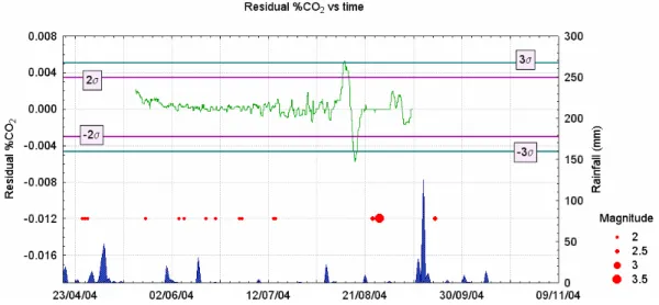
Fig. 20. The residual of CO2signal vs. time. Time interval: 18 May 2004–9 September 2004.
An additional confirmatory step to assess an anomalous signal is to determine its deviation from its stationary be-haviour in the time domain. Calculation of the autocorre-lation coefficient for a time lag up to 48 h shows a strong au-tocorrelation of the %CO2signal. Such a situation suggests
that uncorrelated residuals can be used as a possible way to determine anomalies; thus, the observed time series, shifted by one sample (1 h), has been subtracted from the original one, giving a series of finite difference values, the result of which is shown in Fig. 20. The irregular signal (%CO2
resid-ual) peaks at ±3 from its average value in correspondence with the cited anomaly found in the scatterplot, reinforcing the evaluation of the anomaly.
On 27 August 2004 a M=3.7 earthquake with epicentre in the Apuan Alps (3 km horth of Equi Terme) occurred.
Even if this event does not give authorisation to indicate the above-described anomaly in the signals necessarily con-sidered as precursory phenomena, the multidisciplinary ap-proach utilised in this investigation allows us to describe the natural variability of the aquifer systems and shows sev-eral promising aspects regarding the assessment of possible earthquake precursors.
Acknowledgements. Thanks are due to the Seismic Service Office
of Tuscany Region, Italy, that has financed this research. Authors are grateful to R. Drysdale (University of Newcastle, Australia) for reviewing the manuscript in its last version. Rainfall data recorded at the Aulla, Careggine, Villa Collemandina and Bagni di Lucca stations have been supplied by ARSIA, Pisa. Rainfall data recorded at the Castel del Piano station have been supplied by Ufficio Idrografico e Mareografico di Pisa.
Edited by: A. Loukas Reviewed by: 3 referees
References
Baldacci, F. and Raggi, G.: Lineamenti geologici e idrogeologici della regione dell’Appennino Ligure Toscano a nord dell’Arno. Contributo alle conoscenze delle risorse geotermiche del territo-rio italiano, C.N.R., PFE-SPEG, RF 13, 68–85, 1982.
Baldacci, F., Cecchini, S., Lopane, G., and Raggi, G.: Le risorse idriche del bacino del fiume Serchio ed il loro contributo all’alimentazione dei bacini idrografici adiacenti, Mem. Soc. Geol. It., 49, 365–391, 1993.
Bencini, A., Duchi, V., and Martini, M.: Geochemistry of ther-mal springs of Tuscany, (Italy), Chemical Geology, 19, 229–252, 1977.
Bencini, A., Brondi, M., Dall’Aglio, M., Duchi, V., Quattrocchi, F., and Venni, G.: Ricerca di siti idonei all’istallazione di stazioni di monitoraggio di parametri idrogeochimici pertinenti ai terremoti, nell’area della Garfagnana, Atti GNGTS, 101–114, 1990. Biagi, P. F., Ermini, A., Kingsley, S. P., Khatkevich, Y. M., and
Gordeev, E. I.: Possible Precursors in Groundwater Ions and Gases content in Kamchatka (Russia). Phys. Chem. Earth, A, 25, 295–305, 2000.
Boschetti, T., Venturelli, G., Toscani, L., Barbieri, M., and Muc-chibo, C.: The Bagni di Lucca thermal waters (Tuscany, Italy): an example of Ca-SO4waters with high Na/Cl and low Ca/SO4
ratios, J. Hydrol., 307, 270–293, 2005.
Calamai, A., Cataldi, R., Squarci, P., and Taffi, L.: Geology, Geo-physics and Hydrogeology of the Monte Amiata Geothermal Field, Geothermics, Special Issue 1, 1–9, 1970.
Calvi, E., Caprai, A., Leone, G., and Mussi, M.: Isotopic and chem-ical composition of some thermal groundwaters and associated gases in the Serchio river valley, Northern Tuscany, Italy, Atti Soc. Tosc. Sci. Nat. Mem., Serie A, 106, 45–53, 1999.
Carapezza, M. L., Cioni, R., Guidi, M., Lelli, M., Pruiti, L., Ricci, T., and Scozzari, A.: The importance of automatic continuous geochemical monitoring in an open conduit volcano (Stromboli, Italy), EGS-EGU, Vienna, 2005.
Carmignani, L., Decandia, F. A., Fantozzi, P. L., Lazzarotto, A., Liotta , D., and Meccheri, M.: Tertiary extensional tectonics
in Tuscany (Northern Appennines, Italy), Tectonophysics, 238, 295–315, 1994.
Celati, R., Grassi, S., and Calore, C.: Overflow thermal springs of Tuscany (Italy), J. Hydrol., 118, 191–207, 1990.
Chiodini, G., Cioni, R., Di Paola, G., Dotsika, E., Fytikas, M., Guidi, M., Leonis, C., Lyberopoulou, V., Magro, G., Marini, L., Meletidis, S., Michelot, J. L., Poutoukis, D., Raco, B., Russo, M., and Virgili, G.: Geochemistry of Santorini fluids, Final Report, Contract EV5V-CT93 (DG12 SOLS), 1996.
Cioni, R., Guidi, M., and Raco, B.: The Automatic Geochem-ical Monitoring of Volcanoes project, final Report on the re-search project supported by contract ENV4-CT96-0289 (DGXII-ESCY), project co-ordinator: Allard, P., 1999.
Cioni, R. and Guidi, M.: European Mobile Early Warning System, final Report, Contract ENV4-CT98-0728 (DG12-ESCY), 2001. Jolivet, L., Faccenna, C., Goff´e, B., Mattei, M., Rossetti, F., Brunet,
C., Storti, F., Funiciello, R., Cadet, J. P., D’Agostino, N., and Parra, T.: Midcrustal shear zones in postorogenic extension: ex-ample from the northern Tyrrhenian Sea, J. Geophys. Res., 103, 12 123–12 160, 1998.
De Stefani, C.: Le acque termali di Torrite in Garfagnana, Boll. Soc. Geol. It., XXIII, I, 117–148, 1904.
Duchi, V., Minissale, A., Paolieri, M., Prati, F., and Valori, A.: Chemical relationship between discharging in the Siena-Radicofani graben by the geothermal field of the Mt. Amiata, Torre Alfina and Latera (central Italy), Geothermics, 21, 401– 413, 1992.
Eva C., Giglia G., Graziano F., and Merlanti, F.: Seismicity and its relation with surface structures in the North-Western Apennines, Boll. Geof. Teor. Appl., XX, 79, 263–277, 1978.
Fancelli, R. and Nuti, S.: Studio sulle acque geotermiche e minerali della parte orientale della provincia di Siena, Boll. Soc. Geol. It., 94, 135–155, 1975.
Fancelli, R. and Agostini, G.: Le acque di Bagni di Lucca nei loro rapporti con le altre manifestazioni idrotermali nella Toscana set-tentrionale, Atti delle giornate Bagni di Lucca Terme; Bagni di Lucca, 3–4 maggio 1980.
Fanelli, M., Bellucci, L., and Nachira, F.: Manifestazioni idroter-mali italiane. CNR – PFE, Geothermal Energy Subproject RF 13, Appendix, 1982.
Francalanci, G. P.: Contributo per la conoscenza delle manifes-tazioni idrotermali della Toscana, Atti Soc. Toscana Sci. Nat., Serie A 65, 373–432, 1959.
Frepoli, A. and Amato, A.: Contemporaneous extension and com-pression in the Northern Apennines from earthquake fault-plane solutions, Geophys. J. Int., 129, 368–388, 1997.
Frepoli, A. and Amato, A.: Spatial variation in stress in peninsu-lar Italy and Sicily from background seismicity, Tectonophysics, 317, 109–124, 2000.
Garavaglia, M., Braitenberg, C., Zadro, M., and Quattrocchi, F.: Radon measurements in soil and water in the seismic Friuli area, Il Nuovo Cimento, 22C, 415–422, 1999.
Hartmann, J. and Levy, J.: The influence of seismotectonics on the precursory changes in groundwater composition for the earth-quake, Japan, Hydrol. J., 14, 1307–1318, 2006.
Johansen, A., Saleur, H., and Sornette, D.: New evidence of quake precursory phenomena in the 17 January 1995 Kobe earth-quake, Japan, The European Physical Journal B, 15, 551–555, 2000.
Johansen, A., Sornette, D., Wakita, H., Tsunogai, U., Newman, W., and Saleur, H.: Discrete scaling in earthquake precursory phenomena: evidence in the Kobe earthquake, Japan, J. Phys. I France, 6, 1391–1402, 1996.
King, C. Y.: Gas geochemistry applied to earthquake prediction: an overview, J. Geophys. Res., 91, B12, 12 269–12 281, 1986. King, C. Y.: Gas geochemical approaches to earthquake prediction,
In: Radon Monitoring in Radioprotection, Environmental Radio-Activity and Earth Sciences, ICTP, Trieste, 244–277, 1989. Langelier, W. F. and Ludwig, H. F.: Graphical methods for
indicat-ing the mineral character of natural waters, J. Am. Water Works Ass., 34, 335–350, 1942.
Marinelli, G.: Gen`ese des magmas du volcanisme Plio-Quaternaire des Apennines, Geol. Rundsch., 57, 127–141, 1967.
Masini, R.: Studi geoidrologici sulle acque fredde e calde (Alpi Apuane e bacino del Serchio), Boll. Servizio Geologico d’Italia, 78, 709–788, 1956.
Masini, R.: Le terme di Equi (Alpi Apuane) e l’origine delle sor-genti termominerali, Boll. Servizio Geologico d’Italia, 85, 95– 125, 1964.
Meletti, C. and Valensise, G.: Zonazione sismogenetica ZS9. Gruppo di lavoro per la redazione della mappa di pericolosit`a sismica, zonesismiche.mi.ingv.it/documenti/App2.pdf, 2004. Nucci, M., Marchetti, G., Guidi, M., Zanzari, A. R., Scozzari, A.,
and Galli, G.: Geochemical responses of the aquifers to the seis-mic events: the Micrat project, AVR05 Aquifer Vulnerability and Risk International Workshop, Piacenza, 2005.
Peccerillo, A.: Multiple mantle metasomatism in central southern Italy: geochemical effects, timing and geodynamic implications, Geology, 27, 315–318, 1999.
Pieri, C. and Burichetti, E.: L’acqua termale di Pieve Fosciana. Analisi, indagini e considerazioni chimico-fisiche, Atti Soc. tosc. Sci. Nat. Mem., 40, 1–20, 1930.
Pulinets, S. A. and Dunajecka, M. A.: Specific variations of air temperature and relative humidity around the time of Michocan earthquake M8.1, 19 September 1985 as a possible indicator of interaction between tectonic plates, Tectonophysics, 431, 221– 230, 2007.
Quattrocchi, F. and Calcara, M.: Test-site for earthquake prediction experiments within the Colli Albani region, Phys. Chem. Earth, 23, 915–920, 1998.
Quattrocchi, F., Guerra, M., Pizzino, L., and Lombardi, S.: Radon and helium as pathfinders of fault systems and groundwater evo-lution in different Italian Areas, Il Nuovo Cimento, 22 C, 309– 316, 1999.
Rosini, R., Di Luccio, F., and Barba, S.: Focal mechanism in the Apennines, Phys. Chem. Earth, 21, 273–278, 1997.
Serri, G., Innocenti, F., and Manetti, P.: Geochemical and petrologi-cal evidence of the subduction of delaminated Adriatic continen-tal lithosphere in the genesis of the Neogene-Quaternary magma-tism in central Italy, Tectonophysics, 223, 117–147, 1993. Singh, R., Cervone, G., Singh, V., and Kafatos, M.: Generic
precur-sors to coastal earthquakes: Inferences from Denali fault earth-quake, Tectonophysics, 431, 231–240, 2007.
Thomas, D.: Geochemical precursors to seismic activity, PA-GEOPH, 126, 241–266, 1988.
Toutain, J. P., Baubron, J. C.: Gas geochemistry and seismotecton-ics: a review, Tectonophysics, 304, 1–27, 1999.
Raggi, G.: Foglio 96 Massa, Note illustrative della Carta geolog-ica d’Italia, scala 1:100.000, Servizio geologico d’Italia, 1971. Ulomov, V. I. and Mavashev, B. Z.: Forerunners of the Taskent
earthquake, Izvestia Akadamiyi Nauk Uzbeckistan SSR, 188– 200, 1967.
Wakita, H.: Water wells as possible indicators of tectonic strain, Science, 189, 553–555, 1975.
Wyss, M. and Booth, D. C.: The IASPEI procedure for the evalu-ation of earthquake precursors, Geophys. J. Int., 131, 423–428, 1997.
Zanzari, A. R., Martinelli, A., Cioni, R., Guidi, M., Raco, B., Scoz-zari, A., Quattrocchi, F., Galli, G., and Mancini, C.: Discrete and continuous monitoring of groundwater in the seismic area of the Umbria region (Italy), Proceeding of Water-Rock Interaction 2001, edited by: Cidu, R., Swets, J. A., and Zeitlinger, N. V., Lisse, ISBN 90 2651 824 2, 1, 119–122, 2001.