HAL Id: hal-01147315
https://hal.inria.fr/hal-01147315
Submitted on 11 Dec 2015HAL is a multi-disciplinary open access archive for the deposit and dissemination of sci-entific research documents, whether they are pub-lished or not. The documents may come from teaching and research institutions in France or abroad, or from public or private research centers.
L’archive ouverte pluridisciplinaire HAL, est destinée au dépôt et à la diffusion de documents scientifiques de niveau recherche, publiés ou non, émanant des établissements d’enseignement et de recherche français ou étrangers, des laboratoires publics ou privés.
To make LUTI models operationnal tools for planning
Mathieu Saujot, Matthieu de Lapparent, Elise Arnaud, Emmanuel Prados
To cite this version:
Mathieu Saujot, Matthieu de Lapparent, Elise Arnaud, Emmanuel Prados. To make LUTI models operationnal tools for planning. 14th International Conference on Computers in Urban Planning and Urban Management (CUPUM), Jul 2015, Cambridge, United States. pp.312:1-19. �hal-01147315�
To make LUTI models operational tools for planning.
Mathieu Saujot
IDDRI - Institut du Développement Durable et des Relations Internationales
Matthieu De Lapparent
IFSTTAR/AME/DEST - Dynamiques Economiques et Sociales des Transports
Elise Arnaud
STEEP – INRIA / LJK - UJF
Emmanuel Prados
STEEP – INRIA / LJK - UJF
CUPUM 2015
Abstract: Land Use and Transport Integrated models (LUTIs) are promising tools for urban planning. Although a large literature is dedicated to these models, little attention has been paid to them as operational tool for planners and few efforts have been made by academics to fill the gap between lab application and operational use for planning practice. We shed light on what would make them accepted and more used by planners to evaluate urban and transport policies. In addition to a literature review and reflection on our own experience, we carried out a survey of end users in France to identify their motivations and barriers to using LUTI models. Our analysis shows a need for a far more bottom-‐up oriented approach. Only a closer collaboration between modelers and end users, and more efforts to integrate modeling into urban planning will make LUTIs considered as relevant approaches.
Keywords: Land Use and Transport Integrated modeling; Planning support system, Planning practice
1. Introduction
1.1 Research background
A large literature is dedicated to Land Use and Transport Integrated models (LUTIs). This family of urban models and their applications to territories have been described, reviewed and discussed in many articles (Simmonds et al., 1999; Wegener, 1994; Wegener, 2004; Iacono et al., 2008; Hunt et al., 2005; Lautso et al., 2004; Jin and Wegener, 2013). This literature has been useful in developing and improving modeling principles and illustrates what we can theoretically expect from the models to inform policymakers. However it says little about their daily use, their maturity for operational use and their potential impacts for planning and decision making. The discussion is generally oriented towards technical and theoretical features, and the question of whether the model can support an actual planning decision is poorly considered. Hunt et al. (2005) for example aim at providing a
practical evaluation of the current modeling framework as a guide to practitioners. Yet, they mainly focus on the formal characteristics of the modeling frameworks and the way they represent the different dimensions of urban systems. A concrete discussion on how these models were used and on the practical difficulties of modeling is missing and the suggested improvements are not taken from practice but from an ideal model. As observed by Vonk et al. (2005) and Wegener (2011), the Planning Support System (PSS) and LUTI modeling community is often focused on academic issues, with a “strong emphasis on the supply side” (Vonk et al., 2005) and a lesser concern to investigate the practical and daily use of models by practitioners.
Whether these models can be operational and under which conditions they can improve planning methodologies and policy design are important issues that must be more discussed. Originally the objectives of LUTIs were twofold (Batty, 1979; Batty, 2009; Klosterman, 2012; Lee, 1994):
1) improve, develop and test a theory for urban systems; 2) improve policy design and planning methodologies
We still lack research on the latter. Even if some elements are available based on the experience of planners, researchers (Lee, 1973; Lee, 1994; Klosterman, 1994a, 1994b, 2012), or modelers (Waddell, 2011; Timmermans and Arentze, 2011), this discussion is rarely the main purpose of the article and rarely based on a dedicated methodology. Lee (1973, 1994) was one of the first to discuss LUTIs from an operational planning view, pointing out the inherent difficulty of using complex modeling tools to feed a decision making process. Wegener (2011) discussed the disaggregation trend in modeling and the technical difficulties of using micro-‐simulation modeling in planning. Waddell (2011) described the many challenges – technical and non-‐technical – of transferring modeling tools from academic research to planning agencies. Noteworthy contributions also come from the PSS literature, even though they are not focused primarily on LUTIs. Vonk et al. (2005) investigate the bottlenecks blocking a wide usage of PSS, including LUTIs and other tools, with a survey of people involved in PSS (mainly academics and researchers). Brömmelstroet and Bertolini (2008) shed light on obstacles that explain low levels of use by exploring the planning process. They clearly show the necessity to connect end users (State transport services, local transport authorities, planning agencies, consultancies) and modelers through specific procedures and tools.
As highlighted by Klosterman (2012), modeling “reflects more fundamental assumptions about the limits of science, the role of the public, and the nature of planning”, and requires thinking in terms of policy making and not only in terms of technical issues. Although LUTIs greatly improved during the last two decades, they are not yet widely disseminated. End users still seem indecisive about using them. As a result, they are primarily considered as research objects. The gap between lab application
and operational use for planning practice is still to be filled (Wegener, 2011; Silva and Wu, 2012; Brömmelstroet and Bertolini, 2008; Aashto, 2007). Thus we still need to better understand how LUTIs are currently used, the barriers to their practical use and how they could better inform planning decisions and transport policies in practice. Doing so should help us identify the priorities for a LUTI agenda.
1.2 Structure of the paper
This article aims at improving the understanding of conditions under which LUTIs would be accepted and used by planners and practitioners. Toward this goal, we conducted a qualitative survey among French practitioners about their experience and expectations regarding LUTI modeling. 20 questions about urban modeling practice and demand for LUTI models were prepared. Hardy’s survey (Hardy, 2011) was used as a basis for several questions. The survey was sent to 30 French modeling
practitioners (mainly in the transport field) between summer and autumn 2013. We received answers from 15 of them. They constitute a representative panel of the types of relevant
stakeholders (consultancies, State departments, local authorities and planning agencies). To improve the response rate, the sample was targeted to a sample with: 1) a good level of modeling and the possible presence of innovation; 2) a diversity of actors; 3) when possible, existing contacts with researchers of the CITIES project consortium1. Of course, this strategy2 may introduce a bias, for
example, toward an overestimation of the interest that LUTIs represent for the whole stakeholder community. In any case, the results of the survey should be at least representative of the group of stakeholders who are real potential users in the medium term.
In order to complete the results of the survey, we also conducted 8 qualitative interviews with key transportation actors at the French national and local level: a high-‐level expert from the ministry of sustainable development, a modeler from French national railway network (RFF), the chief economist
1 The CITIES project’s ambition is to foster the use of LUTI, by developing methodologies and tools to facilitate
their use (numerical methods to help calibration and validation). The consortium includes mathematicians and computer scientists, most of French LUTI modeling teams and end users (planning agencies). Different LUTI are used (Urbansim, TRANUS, Pirandello). The project is financed by the French research agency (ANR).
2 Via the choice of the interviewees (of whom a large part have connections with the researchers) but also
because of the survey principle itself (where people who feel more concerned by the object of interest are more willing to answer).
of the Société du Grand Paris (SGP), modelers from Île-‐de-‐France urban transport authority (STIF), modelers from Greater Lyon area and three consultancies. These interviews helped us understand the maturity level of LUTI modeling and the conditions for LUTI diffusion.
By combining the experience of the project consortium, the survey and the interviews, we assume that we have a representative view of the French context. This study is completed by a review of the scientific literature that extends to work outside France.
The rest of the paper is organized as follows. In the second section, we specify the different purposes of using a LUTI and the type of the expected value added. In the third section, we describe the current level of LUTI’s practical use in France as well as in Europe and in the United states. The fourth section addresses the obstacles facing practical LUTI use and suggests some ways to overcome these difficulties. We draw our conclusions in the last section.
2. LUTIs for policy design
When a LUTI is used in a policy design project, its real purpose is not always clear. For example, as observed by Lee (1994), there is often an ambiguity between tactical and strategic use. To help policy design, we need to better understand how a LUTI can be used, i.e. which outputs can be provided, and in which step of the decision making can be useful.
2.1 Policy design: which outputs?
Our survey shows that, for French stakeholders, it is important to take into account transport and land use in an integrated way, and modeling tools are an interesting way to do so. Alongside other methods and types of analysis, modeling tools are considered important to evaluate or design land use and transport policies. Another key lesson from our survey and interviews is that end users have very heterogeneous expectations about LUTIs. Several objectives for LUTI modeling can be found among the different projects and actors:
• To make the spatial distribution of jobs and population/households endogenous (potential use by transport authority);
• To simulate effects of transport on land use;
• To evaluate effects of transport on land and housing prices (when data and models will be integrated enough to provide such outputs at a very detailed geographical scale);
• To assess environmental, social and economic impacts of urban dynamics and urban development scenarios;
• To test and recommend land use and transport policies to mitigate urban sprawl or improve sustainability;
• To perform an overall cost-‐benefit analysis of a transport project (accounting for wider economic benefits);
• To present projects and discuss them with stakeholders, LUTIs being used as a support for the debate and participatory process.
Such a large spectrum of objectives has the following implications. First, users’ requirements seem more diversified for LUTI modeling than for traffic modeling. This clearly makes the development of a commercial offer more complex since the demand is not precisely defined. Second, when presenting and judging a LUTI and its application, one should always refer to the specific outcome(s) that are expected from the model and show consistency between the objectives of the application objectives and the structure of the model. Third, it has implications for calibration and validation goals and procedures.
2.2 Policy design: which step of the decision making process?
It is not enough to define the expected outputs. We also need to specify the step of planning targeted by the use of a LUTI, and the way its outputs could be used by end users in the decision making process. The fundamental goal is to adjust the models to their role in the policy making process. Indeed, both PSS literature (Brommelstroet and Bertolini, 2008; Klosterman 2001) and science-‐policy interface literature (Sager and Ravlum, 2005; Vechionne, 2012) reveal the complexity of the link between modeling tools and decision-‐making process. As stated by Nilsson et al. (2008), “more than three decades of policy analytic research remind us that the inter-‐relationship between assessment tools, the evidence they reveal, and their use by policy makers is unlikely to be
straightforward”.
As in Hardy (2011), in our survey, we proposed different steps of policy design where LUTIs could be used: 1) Exploration of planning possibilities and different strategies 2) Debate around scenarios and consultation with stakeholders 3) Strategic analysis of different scenarios and policies 4) Tactical assessment (design of projects). This 4-‐step representation is a strong simplification of the real planning process but remains useful to understand the role of LUTIs.
As shown in Fig. 1, respondents of the survey consider LUTIs useful tools to explore possibilities and strategies (1. and 3.) for the next 20-‐30 years, at an aggregated level (urban area). Tactical
assessment and support for debate appear to be less important. Moreover, the survey reveals that the use of a LUTI would be most helpful in the process of defining the strategic urban planning
document at the level of an urban area, which is coherent with the precedent answers. This is illustrated in Fig. 1.
Fig. 1: Survey results: for which step of policy and planning document would LUTIs be the most useful?
Even among identical end users, we observe very heterogeneous results concerning the impact assessment3 of transport infrastructure (a document which refers to a tactical use of the model),
reflecting indecision between tactical use and strategic use.
3 a formal/ administrative document for setting up a new transport infrastructure, including a cost benefit
analysis 0% 20% 40% 60% 80% 100% Exploranon Debate & consultanon Strategic analysis Tacncal assessment Not important Somewhat important Important Very important 0% 20% 40% 60% 80% 100% Impact assessment of large transport
infrastructure Zoning at the city
level Transport plan at the agglomeranon
level Urban planning at
the urban area level
Not important Somewhat important
Now that we have clarified the different expectations about LUTIs, we must evaluate to what extent they are used in practice to inform planning strategies.
3. Useful LUTIs but are they used?
3.1 United States and Europe
As stated earlier, a gap between research and practice exists both in Europe and in the US. New generations of models were created to contribute to policy design, but they are not mature enough to succeed in this field (Iacono et al., 2008). In a recent survey in the US, Lee (2009) and Hardy (2011) observe that very few Metropolitan Planning Organizations use LUTI models. Moreover, the role of modeling tools in planning in the US is not clear (Hardy, 2011). Apart from in the UK, which seems to be the place where LUTIs are the most commonly used for planning (May et al., 2008), LUTI modeling is not that much developed in Europe. We do however highlight the recent Sustaincity project4 that
contributed to the development of LUTI models and helped increase their popularity in Europe. Wegener (1994, 2004, 2014) reviews implementation of such models.
3.2 The French context
Daily use of LUTIs for the simulation of regional planning policies is still an exception in France, despite important research investments and recent interest of planning agencies. LUTIs have only been developed for research projects since the mid 2000’s: Urbansim (Nicolas et al., 2009; Nguyen-‐ Luong, 2008); TRANUS (Saujot, 2013); and Pirandello (Delons et al., 2008). To date, no French local authority for planning or transport has appropriated the LUTI developed by academics specifically on its own territory, or developed its own LUTI.
In fact, the only example of an operational use of a LUTI is the Grand Paris project5, undertaken by
the “Société du Grand Paris” (SGP). The Grand Paris project is the most important urban project in France, with a 30 billion € investment in the next 20 years, mainly for new transport infrastructures. The SGP is in charge of the socio-‐economic impact assessment and they have constructed an ambitious program around LUTIs. A scientific committee has been set up to assess the modeling work done in parallel by three teams, each with a different tool (Relu-‐Tran, Urbansim, Pirandello). After of four years, work is in process, but preliminary results show that using LUTIs for an
operational project is much more difficult and time-‐consuming than expected. Moreover, the data
4 FP7 project funded by European Union: http://www.sustaincity.org 5 http://www.societedugrandparis.fr/english
collection task was under-‐estimated and the question of the relevant scale of zoning was a
permanent debate. It is difficult for the experts of SGP to obtain satisfying answers about the results and behavior of the models, and reciprocally it is difficult for modelers to explain precisely the differences between the respective models’ results for a given scenario. This example shows clearly that even with an important budget and a high level of expertise, using LUTIs to help decision making for a project like the Grand Paris is very difficult. Although this kind of project helps LUTI modelling gain in maturity, LUTI modeling is not mature enough for practical use at least in France.
Nevertheless, despite the difficulties and the non-‐legal obligation to evaluate spatial effects, the SGP considers that it is essential to continue to develop LUTIs for broader socio-‐economic evaluation in planning and sustains its efforts.
Another meaningful example can be drawn from the experience of the Greater Lyon6. A consortium
of 5 local actors was created to set up a new common transport model (region, department, State at the regional level, Greater Lyon, local transport authority), with an important budget. They
considered the possibility of using a LUTI instead of a classical 4-‐steps transport model but concluded that it was not the right choice for three reasons: a lack of appropriate guidelines for LUTI
implementation; insufficient expertise both inside and outside the consortium to ensure a good choice of a model, and high risk relative to a long and uncertain process of building the model. As far as the consulting firms specialized in transport modeling in France are concerned, no ready -‐to-‐ use LUTI package is available at this point. The market situation (low visibility in terms of demand, financial constraints and short implementation periods) makes it difficult for consultancies to
develop their own models. This pushes some firms to think that LUTIs are not well adapted to current public demand. For others, it reinforces the need to find a strict trade-‐off between quality and simplicity of the LUTIs. Beyond the model, the general diffusion of LUTIs would require the
development of national guidelines. Such guidelines exist for conventional transport modeling but not for LUTIs, and the scientific literature is generally of little assistance for end users.
4. A need for more bottom-‐up approaches
What prevents LUTIs from being widely used by local authorities? Are current LUTIs suitable with respect to their constraints and limitations? The main obstacles associated with these issues are threefold. First, it is difficult to match rather generic models with very specific and varied end user questions. Secondly, it is costly and challenging to implement and use a LUTI (capacity obstacles).
Finally, there is no guarantee that the results of a dedicated LUTI will have any impact on the policy design (decision making obstacles).
4.1 Matching with end user expectations
A key idea is that one can only ask a numerical model questions it was created for. Even with the progress in computer science (language, algorithm) and technology (computational power), the numerical problems derived from urban systems are very complex, and we are forced to simplify reality in order to be able to solve them. Without precise questions, it is not possible to reduce the model in the right direction. However, our experience shows that end users usually do not know how to precisely formulate the questions they want to answer with the model. Indeed, they are not LUTIs experts and planning questions are very vast. Nevertheless, modelers need these questions in order to develop a relevant model. It is difficult to solve this knot not only because it is costly for end users to become familiar with LUTIs and to understand the questions they can address, but also because it is costly for researchers or consultants to develop different model versions in an iterative co-‐building process.
The interviews reveal that it is very difficult for non-‐specialists of LUTIs to follow the progress of science and to judge the value of a model. Workshops organized at the national level in France are not sufficient to really understand to what extent these models are operational, and to identify the pros and cons of each model (the black box effect, the complexity of these tools, a research dynamic that “adds complexity to complexity”, and the difficulty for researchers or developers to underline the weaknesses and limitations of their model). To overcome these difficulties, workshops should go further in practical details and reveal the actual level of maturity of LUTIs; they should also help gather end users expectations.
4.2 Local resource limitation vs. growing complexity
Capacity limitations are strong binding constraints because of the growing complexity of LUTIs. This gives rise to the simple/complex model debate. The scientific community tends towards more and more complexity (Timmermans and Arentze, 2011) and this is favored by an increasing
computational power (Iacono et al., 2008), see Fig. 2. Academic logic seeks innovation and sophistication in modeling tools, and usability is probably not the main objective of researchers. Moreover Wegener (2011) observes with Lee (1973) that the “urban modeling community largely retreated to academia”. This approach focusing on tool development can be identified as “top-‐ down”. As illustrated in Fig. 2, adding complexity has its limits, and simpler and easier modeling is still necessary (Hardy, 2011; Klosterman, 2012; Brömmelstroet and Bertolini, 2008; May et al., 2008).
Drivers Limits
1. Complexity → more hypotheses, with a strong impact on results, not always discussed.
2. Complexity can seem neutral (sophistication let think there is no modeling choices), but no models are neutral.
3. Possible development of “non essential” complexity.
4. Marginal cost to get micro data sometimes bigger than value added. 5. Not focused on the integration into
the planning process.
Fig. 2: A move towards more complexity -‐ drivers and limits of complexity; Illustration based on
(Klosterman, 2012; Hardy, 2011; Wagner and Wegener, 2007)
Model complexity is a combination of the theoretical complexity of a tool and implementation design. The theoretical structure defines the number of equations to satisfy, the number of input-‐ ouput loops, and the quantity of required data. In the same time the implementation design define the number of modeled phenomenon in the model and the spatial meshing. The sum of this determines the time, the money and the level of expertise needed for the modelling process, which eventually must be compared to the capacity of the planning agency. It will determine the success of the modelling project. Thus, it is essential to better understand the level of required complexity and to adapt a model according to its final objectives. Complexity should therefore be understood as the confrontation between modeling and local capacity. In this context, it makes sense to oppose the “top-‐down” approach, focused on tool development (by itself), to the “bottom-‐up” approach which focuses on operational planning needs and limitations, as illustrated by Hardy (2011), Klosterman (2012), May et al. (2008) and Brömmelstroet and Bertolini (2008), and where more attention is paid to simplifying models. Bottom-‐up approaches have been neglected; however, it seems that such approaches are the only way to ensure operational LUTIs.
In France, we observe that one of the main obstacles to LUTI implementation comes from the resource limitation of local agencies in terms of time, money and expertise. LUTIs are very
Advances in computation and econometrics Researchers focused on the development of tools Theoretical ambition Predictive science facing a complex world Complex models Epistemology related issues Implementation issues Decision help issues
demanding in data collection, harmonization and preparation, and require modeling and
econometric capabilities. Appropriated methodologies and quantitative modeling skills are not very standardized or widely disseminated. Any implementation of a LUTI requires a very time consuming step of calibration. This process can take several months, as our experience with TRANUS in Grenoble has shown. Clearly the time required to calibrate is neither compatible with the current constraints of consulting firms nor with the resource restriction of local agencies.
4.3 Decision making obstacles
Even assuming that capacity obstacles can be overcome and that a LUTI can be built to serve in a decision making process, there is no guarantee that its outcome will be of any use. In this section, we analyze the difficulty of understanding the model outputs before using them for decision making.
4.3.1 Black box effect
The “black box” problem, based on the literature and on our own experience, implies the difficulty to promote results of LUTI models among practitioners who have no direct control over the
implementation of these models, because they do not trust what they can’t understand. As
Timmermans (2003) stated, there is a paradox between the search for more modeling complexity, in order to represent the complexity of urban systems, and the black box effect; a paradox from which it is difficult to escape. Waddell (2011) observes a conflict between transparency (which needs simplicity) and validity (which needs complexity).
We can distinguish two dimensions of understanding in a model: the global understanding of the model rationale, its architecture and functioning, and the ability to identify causal links between inputs and outputs. Some models can be easy to understand in the first dimension and more complex in the second one. To have an impact on practical planning, a tool needs to be understood in both dimensions: because various people with different profiles and responsibilities are involved (decision maker interested in the philosophy, technician interested in causal effects) and because these two dimensions play a role at different steps of the process (first try with the model, scenario analysis, etc.).
The survey reveals that the black box effect issue is considerable. Several lessons can be learned from the answers to the question on how to solve this problem:
• To clearly distinguish input data, calibration data, parameters and outputs.
• To share and validate every step of the development with all partners.
• To use these models only for very prospective and strategic analyses, mainly for pedagogy.
Furthermore, the fact that modeling tools are not used in the planning process is explained very differently by planners and modelers. Modelers would often consider that models are not complex enough to represent reality whereas planners may not see the interest of having details and precisions through a numerical tool and would underline the need for stakeholder involvement (Brommelstroet and Bertolini 2008; Mostashari and Sussman 2005; Timmermans and Arentze; 2011). It is not the purpose of this paper to conclude on the pros and cons of complexity in urban modeling. What we can say from our analysis is that in a theoretical world, complex models are promising and interesting, but in our very constrained world, planning agency capacities are limited. Our study sheds light on the needs for transparent procedures and co-‐construction methods. The latter also asks for resources. A complex model will draw most of the resources for its implementation, limiting the capacity to set up these collaborative procedures. Trade-‐offs must be made. For a broader diffusion of LUTIs in planning processes, academics should emphasize more bottom-‐up approaches.
4.3.2 How reliable are LUTI models?
The low level of use and impact on decision making of LUTIs can also come from a lack of confidence in their results, partly related to the absence of a clear and consensual definition of calibration and validation in the literature (Bonnel et al., 2014). We define calibration and validation as follows (Bonnel et al., 2014):
• Calibration refers to “the determination of parameter values.”
• Validation refers to “testing the predictive power” of the method using out-‐of-‐sample data. • A calibration ensures that the model is acceptable; a validation is always partial since a test
can only invalidate a model.
LUTIs, like any numerical model, are inherently uncertain as they rely on both theoretical
assumptions and data quality. There is no physical law ensuring reliability of models. Consequently, there are neither neutral models (Klosterman, 2012) nor objective rules to state that one
specification is better than another (Sterman, 2000; Pfaffenbichler et al., 2008). Thus there is no absolute calibration or validation, both for simple and complex models. Moreover, new models cannot “meet all basic scientific criteria” and be used for theory testing, but they can provide “robust but contingent knowledge” (Batty, 2009). Calibration and validation should be seen in this respect.
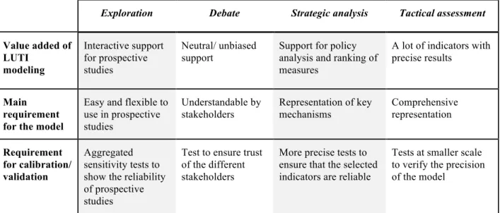
Calibration and validation procedures lead to theoretical, methodological, and practical difficulties (time, resource, data). They need to be understandable by end users in order to produce confidence in the model. Model testing should be specific to the type of expected use, see figure 3.
Exploration Debate Strategic analysis Tactical assessment
Value added of LUTI modeling Interactive support for prospective studies Neutral/ unbiased support
Support for policy analysis and ranking of measures
A lot of indicators with precise results
Main requirement for the model
Easy and flexible to use in prospective studies Understandable by stakeholders Representation of key mechanisms Comprehensive representation Requirement for calibration/ validation Aggregated sensitivity tests to show the reliability of prospective studies
Test to ensure trust of the different stakeholders
More precise tests to ensure that the selected indicators are reliable
Tests at smaller scale to verify the precision of the model
Fig. 3: Calibration and validation requirements depending on the type of use. Historical validation is considered a key step for validation. To be able to simulate a past
development is a clue that the model is working correctly, but it is not a guarantee for prospective modeling. Compared to “hard science” modeling, socio-‐economic models face difficulties in collecting (sufficient) data and replicating results. In a context of low resources, developing a
sensitivity analysis is particularly interesting (Wenban-‐Smith et al., 2009; Franklin et al., 2002; Duthie et al., 2010). It is likely that sensitivity tests using scenarios increase both the scientific value of the modeling process and the understanding of the modeling process by the end user/ practitioner. In our survey, sensitivity tests appear to be decisive to validate the model and increase transparency. Sensitivity analysis has several benefits:
• To improve the model. As a way to validate the model, it improves the quality of modeling. Back and forth work between the calibration stage and sensitivity tests can be possible. • To increase involvement of stakeholders. Via the sensitivity analysis, the end users can
test outputs. By taking part in the design and validation phase of the model one can guarantee better ownership of the model by the stakeholders.
• To overcome the black box effect by increasing confidence. It increases the ability of the end users to understand the processes. Tests should be chosen to help end users understand the most complex links and interactions in the model.
5. Conclusion.
In conclusion, top-‐down approaches have been historically useful to provide different structures of LUTIs. Today however we need more bottom-‐up approaches if we are to make LUTIs a relevant operational planning tool. This will require a closer collaboration between modelers and end users, as well as a greater effort to integrate modeling into urban planning. Finally, in order to improve the impact of models on planning, more research is needed to explore the socio-‐technical aspects of their adoption and use.
6. References:
• American Association of State Highway and Transportation Officials (2007). Forecasting
Indirect Land Use Effects of Transportation Projects, December 2007: Aashto
• Batty, M. (1979). Progress, success and failure in urban modeling. Environment & Planning A, 11(8): 863-‐878.
• Batty, M. (2009). Urban modeling. In: R. Kitchin and N. Thrift (eds.), International
Encyclopedia of Human Geography, Elsevier Science
• Bonnel, P., Coulombel, N., Prados, E., Sturm, P. (2014). A survey on the calibration and validation of integrated land use and transportation models. In Proc. of SYMPOSIUM “Toward
integrated modeling of urban systems, 15-‐17 Oct. 2014, Lyon, France
• Brömmelstroet, M.T., Bertolini, L. (2008). Developing land use and transport PSS: Meaningful information through a dialogue between modelers and planners. Transport Policy, 15 (4) 251–259 • Delons, J., Coulombel, N., and Leurent F. (2008). PIRANDELLO an integrated transport and land-‐use model for the Paris area. Preprint: https://hal.archives-‐ouvertes.fr/hal-‐00319087 • Duthie, J., Voruganti, A., Kockelman, K.M., and Waller, S.T. (2010). Highway Improvement Project Rankings due to Uncertain Model Inputs: Application of Traditional Transportation and Land Use Models. Journal of Urban Planning and Development, 136 (4) 294-‐302
• Franklin, J.P., Waddel, P., Britting, J. (2002). Sensitivity analysis approach for an integrated land development & travel demand modeling system. Paper for presentation at the ACSP 44th
Annual Conference Baltimore, MD, November 21-‐24, 2002
• Hardy, M. (2011). Simplified integrated transportation and land use modeling to support
metropolitan planning decisions: an application and assessment. Ph.D thesis, George Mason
University
• Hardy, M. (2012). Using open source data to populate, calibrate and validate a simplified integrated transportation and land use model, Transport Research Board 2012 Annual Meeting • Hunt, J.D., Kriger, D.S., and Miller, E. J. (2005). Current operational urban land-‐use-‐transport modeling frameworks: A review, Transport Reviews, 25(3) 329-‐ 376
• Iacono, M., Levinson, D., El-‐Geneidy, A. (2008). Models of Transportation and Land Use Change: A Guide to the Territory, Journal of Planning Literature, 22(4) 323-‐340
• Jin, Y., Wegener, M. (2013). Beyond equilibrium. Environment and Planning B: Planning and
Design 40(6) 951 – 954
• Klosterman, R.E. (1994a). An Introduction to the Literature on Large-‐Scale Urban Models.
Journal of the American Planning Association, 60(1) 41-‐44
• Klosterman, R.E. (1994b). Large-‐Scale Urban Models Retrospect and Prospect, Journal of the
American Planning Association, 60(1) 3-‐6
• Klosterman, R.E. (2012). Commentary: Simple and complex model, Environment and Planning
B: Planning and Design 39(1) 1-‐6
• Lautso, K., Spiekermann, K., Wegener, M., Sheppard, I., Steadman, P., Martino, A., et al. (2004). Propolis: Planning and Research of Policies for Land Use and Transport for Increasing Urban
Sustainability, Final Report, Project Funded by the European Commission under the Energy,
Environment and Sustainable Development Thematic Programme, February 2004
• Lee, D. B., Jr. (1973). Requiem for Large-‐Scale Models. Journal of the American Institute of
Planners, 39(1) 163-‐78.
• Lee, D.B. (1994). Retrospective on large-‐scale urban models. Journal of the American
Planning Association, 60 (1), 35–40.
• Lee, D.J.H. (2009). TMA/MPO Modeling Activity Survey, Fredericksburg Area Metropolitan Planning Organization.
• May, A.D., Page, M., Hull, A. (2008). Developing a set of decision-‐support tools for sustainable urban transport in the UK. Transport Policy, 15 (6) 328–340.
• Mostashari, A., Sussman, J. (2005). Stakeholder-‐Assisted Modeling and Policy Design Process for Environmental Decision-‐Making, Journal of Environmental Assessment Policy & Management, 7(3) 355-‐386.
• Nguyen-‐Luong, D. (2008). Projet SIMAURIF: Perfectionnement et valorisation, Rapport pour le PREDIT, Juillet 2008
• Nicolas, J.-‐P., Bonnel, P., Cabrera, J., Godinot, C., Homocianu, M., Routhier, J.-‐L., et al. (2009).
Simuler les mobilités pour une agglomération durable. LET, Final Report. 211 p.
• Nilsson, M., Jordan, A., Turnpenny, J., Hertin, J., Nykvist, B., Russel, D. (2008). The use and non-‐use of policy appraisal tools in public policy making: an analysis of three European countries and the European Union. Policy Sciences, 41(4) 335-‐355.
• Pfaffenbichler, P., Emberger, G., Shepherd, S. (2008). The integrated dynamic land use and transport model MARS. Networks and Spatial Economics. DOI 10.1007/s11067-‐007-‐9050-‐7 • Sager, T., Ravlum, I.A. (2005). The Political Relevance of Planners' Analysis: The Case of a Parliamentary Standing Committee. Planning Theory, 4(1) 33-‐65.
• Saujot, M. (2013). Economic analysis and prospective modeling to plan low carbon cities. The
case of Grenoble using TRANUS+ model. Available from : Pastel database http://pastel.archives-‐
ouvertes.fr/pastel-‐00982385
• Silva, E., Wu, N. (2012). Surveying Models in Urban Land Studies. Journal of Planning
Literature, 27(2) 139-‐152
• Simmonds D., Echenique M. et al. Bates J. (1999). Review of Land-‐Use/ Transport Interaction
Models. DETR, 72p. http://www.davidsimmonds.com/files/Review-‐of-‐Land-‐Use-‐Transport-‐
Interaction-‐Models.pdf
• Timmermans, H. (2003). The Saga of Integrated Land Use-‐Transport Modeling: How Many More Dreams Before We Wake Up? Conference keynote speaker, 10th International Conference on
Travel Behaviour Research Lucerne, 10-‐15. August 2003
• Timmermans, H., Arentze, T.A. (2011). Transport Models and Urban Planning Practice: Experiences with Albatross. Transport Reviews, 31(2) 199-‐207.
• Vecchione, E. (2012). Deliberating beyond evidence: lessons from Integrated Assessment Modeling. Paper prepared for the ISEE Conference, Rio de Janeiro, Brazil, 16-‐19 June 2012.
• Vonk, G., Geertman, S., Schot, P. (2005). Bottlenecks blocking widespread usage of planning support Systems. Environment and Planning A, 37(5) 909-‐ 924.
• Waddell, P. (2011). Integrated land use and transportation planning and modeling: addressing challenges in research and practice. Transport Reviews, 31(2)209–229.
• Wegener, M. (1994). Operational urban models: State of the art. Journal of the American
Planning Association, 60 (1), 17–29.
• Wegener, M. (2004). Overview of land use transport models, Chapter 9 in David A. Hensher and Kenneth Button (Eds.): Transport Geography and Spatial Systems. Handbook 5 of the Handbook
• Wegener, M. (2011). From macro to micro—how much micro is too much? Transport
Reviews, 31 (2) 161–177.
• Wegener, M., 2014. Land-‐use transport interaction models. In: Fischer, M.M., Nijkamp, P. (Eds.): Handbook of Regional Science. Heidelberg/New York/Dordrecht/London: Springer, 741-‐758. • Wenban-‐Smith, A., Van Vuren, T., MacDonald, M. (2009). Using Transport Models in Spatial Planning: Issues from a review of the London Land Use/Transport Interaction Model. Association for European Transport and contributors, 2009