HAL Id: hal-01350987
https://hal.archives-ouvertes.fr/hal-01350987
Preprint submitted on 2 Aug 2016HAL is a multi-disciplinary open access
archive for the deposit and dissemination of sci-entific research documents, whether they are pub-lished or not. The documents may come from teaching and research institutions in France or abroad, or from public or private research centers.
L’archive ouverte pluridisciplinaire HAL, est destinée au dépôt et à la diffusion de documents scientifiques de niveau recherche, publiés ou non, émanant des établissements d’enseignement et de recherche français ou étrangers, des laboratoires publics ou privés.
An agent-based model to explore a pluralism of land
regulation in rural Sahel: supplementary data
Hermine Papazian
To cite this version:
Hermine Papazian. An agent-based model to explore a pluralism of land regulation in rural Sahel: supplementary data. 2015. �hal-01350987�
1
An agent-based model to explore a pluralism of land regulation in rural Sahel:
supplementary data
Hermine PAPAZIAN (PhD Student, CIRAD, UPR Green)
1. CONCEPTUAL MODEL
i.
Purpose
The purpose of the model is to support the exploration of a stakeholder-oriented pluralism of regulation regarding the use and management of Sahelian natural resources. The agent-based model simulates the diverse decision-making processes (i.e. the logics of action) of different land actors (users and regulators) when they interact for the access and the use of land and water in a Sahelian environmental context. The outputs of the model result from the simultaneous implementation of the diverse individual decision-making processes.
Figure 1: Conceptual model of the entities’ interactions
To help formalize these uncertain, flexible logics, we performed a direct conceptualisation of the stakeholders' points of view, respecting their perception of the different sources of regulation that can be used according to their own decisions. The model is therefore focused on actors’ perceptions, which
2
means it takes into account every land regulation sources that the actors recognize and use, regardless of whether or not these sources are legally recognized. This is in a way a stakeholder-oriented conceptualization framework.
In this regard, in much of the Sahel, land, natural resources and water official regulations have evolved with very little coordination, and often in different directions. But from the Sahelian actors’ perceptions, these different resources are still closely embedded and it is the inseparable association of it that allows them to realize their activities and to produce the food they need. In order to condense the analysis of this complex reality and try to preserve the stakeholders’ perceptions, water is considered in this study as one of the Sahelian natural resources. Even if the focus is made on land, the same reasoning applies to water sources and their regulators as the one developed below for land regulators and their territories. We consider in this study the term “land” as the gathering of all natural resources from which a user can request access1.
ii.
Case study of Senegal, a Sahelian country
The modelled conceptual framework result from a combination between a bibliographical review, and a field experience through two regional case studies in Senegal, a Sahelian country. The field experience was conducted in two parts:
- between April 2011 and June 2013 we conducted three hundred individual semi-structured interviews within two rural areas in Senegal (Ferlo sylvo-pastoral area and the developed part (mostly irrigated) of the river Senegal valley) considered representing national diversity in terms of issues, tensions and uses that can be made of the land. The two zones differ in their degree of integration of intensive farming, accompanied by a more pronounced appearance of official sources of land tenure regulation in the users' practices for access to land;
- in April 2014, a role-playing game was realized and experimented in these two rural areas to test the reality and conditions of the local mobilization and use of the different sources of land tenure regulation. Two participating workshops, each with 20 players (5 players per board) were set up in the villages of Sinthiou Bamambé in the Ferlo sylvo-pastoral area and Guia, in the the river Senegal valley.
a. The Sahelian environmental context
The Sahelian zone is characterized by extreme ecological and climatic spatial variability and uncertainty. The climate is dry and the rains and temperatures are unpredictable, as highlighted by extremely localized differences in their temporal and spatial distribution. The rainfall quantity varies strongly not only from one year to the next but also over the same year from a land plot to another. Consequently, the level of available resources (such as soil fertility, fodder, non-timber forest products (NTFP)…) vary widely according to the rainfall local context. This ecological variability is also geographical, given the topography and fertility of the soils. Overall, this leads to a very dispersed, heterogeneous and unpredictable distribution of environmental conditions over the years and within a given year.
b. Regulation of the Sahelian natural resources
1 All in all, the land resource can cover the flora, the fauna, and the hydraulic systems as long as they are
3
Sahelian inhabitants, who have evolved for centuries in this setting of extreme variability and uncertainty, have forged territory management rules tailored to this uncertainty and scarcity of resources (Ellis et al. 1988, Mehta et al. 1999)..
First, with land rules and a social organization conducive to high mobility of people and activities (especially pastoral transhumance) (Behnke and Scoones 1992), it is possible to take advantage of the best of this variability by searching and exploiting the best environmental conditions where they are temporarily located. Natural resources not being available enough on the same land plot, it requires users to go fulfill their need of natural resources where they can find some. It is also possible to observe on the same land plot multiple different access rights (linked to multiple users).
Indeed, collective management is preferred over individual appropriation of these resources (Berkes et al. 1989, Ostrom 1990), which are too sparse to be appropriated by an individual. The complex rules that are implemented aim to allow a maximum of individuals to benefit from access to some of these resources. Local rules applied in the Sahel are temporally flexible and dynamic and thus favorable for multi-uses
(
Gallais 1977, Le Roy et al. 1996, Mwangi and Dohrn 2008)
. Some activities being periodic, seasonal, annual, it requires a frequent renewal of the access rights.Choices of activity are linked to a flexible resource exploitation system, based on the integration of multiple activities (several types of farming combined with several types of breeding, harvesting etc. which may require water, and seasonal movements). The logic underlying this exploitation system is focused on a diversification of income sources rather than on the practice of a single intensive activity, which would be too subject to chance and uncertainty.
Choices of activity are also linked to the availability of the water resource. Some activities are indeed not feasible without water supply (for example any breeding activity which requiring the watering of the cattle). Moreover, rural activities are distributed in cropping season, the main representation of Sahelian cropping season temporality being the succession of rainy seasons (from June to October) and dry seasons (from October to June). During the rainy season, rain allows any cropping activity even if a more permanent access right to a water source (like a drilling, a well, a riverside, a hydro-agricultural canal…) is not obtained. Conversely, during the dry season, no rural activity is feasible without a water supply.
c. The bundle of rights approach
In order to describe the multiple forms of rights coexisting within the same area researchers have focused on a “bundles of rights” approach (Le Roy 1996, Mehta et al. 1999, Ribot and Peluso 2003,…), allowing identification of “operational rights” (dealing with land uses) and “administration rights” (dealing with the management of these operational rights, their distribution, conflict settlement, sanctions, etc.).
The “bundles of rights” concept illustrates that there is not one right on the land resources, but numerous rights (to use, administer, transfer, etc.), on various resources (land, trees, forest products, water etc.), and that these rights may be claimed by various users (individual or collective) and under the control of different authorities. A bundle of rights can include: access rights; rights to use; rights to earn income from the use; rights to invest in the use; rights to delegate land use temporarily or without specific terms, in marketable (rent, sharecropping) or non-marketable terms (loan); the right to pledge; and the right to definitively alienate, through a marketable transfer (sale) or donation.
These land rights can be available all year, or only over a certain period (for example a right to use only during the dry or the rainy season) and for a certain duration, from the cropping season up to several years (for example, a user can benefit from a right to use a land only for rainy season during all his life).
4
Access rights can be free, or linked to a certain monetary or non-monetary cost (gifts, labor force, sharecropping, loan, rent etc.).
The nature of the land right, what it allows, its cost, its duration, and a set of other criteria help constituting a specific perception of land tenure security for each Sahelian user, which conditions his choice of rural activity in relation with the act of investment he can consider. Indeed, the perception of land tenure security can be affected by the nature (and the need of investment) of the rural activity performed (Bruce and Migot-Adholla 1994). For example, an oral periodic right to use a land only during the rainy seasons can be considered safe enough to realize extensive cropping (millet, sorghum, maize, fonio…), but not safe enough to start more intensive cropping (groundnut, fruit trees, market gardening…). Land tenure security is therefore in this approach considered as a feeling, resulting from a dynamic process which changes and adapts itself to the conditions of a given context (Bruce and Migot-Adholla 1994, Le Roy 1999, Cotula 2012).
Besides, even if the focus is made, for the clarity of the analysis, on the consideration of two main types of distinct land actors (users and regulators), the boundaries between users and regulators can in reality be very fuzzy. When Sahelian users benefit for example from a part of the bundle of rights that allow them to delegate their land access right, they become themselves regulators, and can decide according to their own logic of action to share their land with other users, through marketable (rent, sharecropping) or non-marketable terms (loan).
This last statement leads to the question of the spatial and social scale of exploration of the stakeholder-oriented pluralism of regulation. Whether we consider the regulation or the use of land resources, each “collective scale”: a family, a village, a lineage, a local community, an ethnic group, etc. can include intra/inter forms of land regulation pluralism, which express itself to the spatial scales of a land plot, a farm, a territory village, a rural community, a region, a country…
d. A stakeholder-oriented pluralism of land regulation sources
As the land tenure policies set up by states do not recognize the local regulation sources described above, they have used approaches to land tenure and ownership that are too different to the local context for it to be possible to remove them (Mwangi and Dohrn 2008). The management of land resources is therefore built on several overlapping land regulation systems where numerous regulators intervene.
The Senegalese decentralization land policy officially provides a territory management mandate to local communities, who deliver land allocations, equivalent to authorisations of use of the land (users are usufructers of the land they farm). The central State continues to take part in this management, for example by allotting large portions of land through land title (private ownership) often to State members or big investors. Moreover, even if local communities are the official designated territorial management regulators, the traditional system, as described above, is commonly respected, and customary headmen can remain the reference regulators for anything concerning land and natural resources (drawing up of rules, land allotments, regulation conflicts).
This stakeholder-oriented conceptual framework led us to considering the various systems of rules as simple 'potential' sources of regulation. The term 'source' carries the idea that users make partial use of a set of rules and regulatory authorities with no systemic approach. It is not because a user decides at time t to use a particular authority or a particular regulation that he will necessarily adopt the entire functioning and logic of the system with which it is associated. Local stakeholders construct their own 'operation puzzle' by taking pieces for this from the different systems available to them. The puzzle changes as time goes by according to experience and local social interactions that modify the
5
legitimacy of one regulation system or another, or rather of such and such a way of drawing a rule from a regulation system.
e. Interactions processes for the management and use of land access rights
Each regulator of these different land regulation systems has administration rights on a territory, representing a portion of the global landscape. Different regulators can have similar, complementary or overlapping administration rights on the same territories. During his exercise of administration, a regulator has his own perception of the ways he wants to implement the rules and laws on his land territory, and acts therefore according to its own logic, which is not necessarily compatible with that of other regulators. The focus for allocating resource access rights can for example be made on users’ capital, favoring requests of the users with the highest capital or the most intensive activities. But it can also be made on users themselves, by adapting access authorizations to the assurance that all the users of the regulator territory have resource access rights. The focus for allocating resource access rights can also be made on resources environmental state or on customary principles (e.g. primacy to the initial establishment, or transmission to the first son) etc.
Sahelian users also apply their own logics of action, and the various present or past laws are interpreted and used—or not used—according to their perceptions. Users seems to mobilise this pluralism of land regulation at least partially by following an imitation logic, adapting themselves to the prevalent land regulation source (whether it is formal or informal) active in the rural zone where is situated the resources for which they require the access. A user who wants to access a resource will base his decision on the ways the other users that already exploit the spaces which interest him have obtained their own access rights. Another component of a user land tenure security would therefore be the recognition by the other users, because this recognition assures him a non-contesting of his resource access right(s). This prevalence of a land regulation source could be defined as the source of regulation which is the most mobilized by the users of the area already exploiting the concerned natural resource. The prevalence is therefore associated with the nature of the rural activity users want to realize (because this choice of activity defines the need of natural resource: soil fertility if a user wants to farm, fodder if it is a breeder, NTFP if he wants to harvest etc.).
In the same rural zone, several sources of land regulation can overlap according to the activities (and thus the different concerned resources). Some farmers of the area can for example mobilize an official instance such as a local community (or the State) in order to obtain a land allocation (or a land title) for their land while at the same place and time, pastures for the breeders are still managed by oral agreements delivered by customary headmen, with no recognition from the senegalese land law. Following these conditions, a new land regulation (like a new land use policy for example) will be really effective only in the rural zones where it becomes a way of accessing natural resources settled in the practices of the users of the concerned zone.
The nature of the new land regulations introduced until now by land use policies (land title, land allocation, lease…) do not seem to have a value for Sahelian users, they chose to mobilise the new regulation in a strategic way, because it seems to constitute their better land tenure security in the new land insecurity contexts where their already existing practises are not anymore enough. These new sources of land regulation do not initially result from actors practices. Users therefore consider these changes with a certain distance, mobilizing them only in the rural zones where their peers have already legitimized them in their practices of land access. This legitimization seems more to prevent users from the possible effects of these new imposed regulations than to reassure rights susceptible to be locally questioned. This could explains why in the rural contexts where official land regulation sources have not much influence, traditional land regulations remain a sufficient level of safety for users to invest in their rural activities on the only basis of these “customary” informal land rights.
6
f. Adoption of a land regulation change within this stakeholder-oriented pluralism of
land regulation sources
All in all, the evolution of the land tenure situation in rural areas in the Sahel thus shows that these policies have finally accentuated the existing complexity (Bruce and Migot-Adholla 1994, Platteau 1996, Mehta and Leach 1999, Cotula 2012). Indeed, rather than abandoning their practices, local populations have added the land tenure policies set up successively to their pre-existing sources of regulation. It does cause a certain uncertainty that is difficult to grasp (Metah et al. 1999, Mwangi et Dohrn 2008): different stakeholders make therefore claim rights to the same land by referring to different regulatory sources.
The dynamic and diversity of expression of this stakeholder-oriented pluralism of regulation is linked to the concept of perception thresholds, above which changes are observed in users’ practices of mobilisation of land regulation sources, but below which no matter the nature of the introduced change (for example, a new land use policy), it does not seem to be perceived, or in any case considered by Sahelian users.
Changes in land regulation can be introduced through a diversity of intensities (as the proportion of users mobilizing this new land regulation source on a same area) and configurations (as the spatial distribution of the users mobilizing the new land regulation source). This leads to a diversity of landscape composition evolutions at a general scale, according to the introduced changes. For example, a new development project can bring changes in land regulation on one or several contigous areas (the project works with all the users of a village, of a local community, of a hydro-agricultural area…). A new land use policy will however concern all the users of the country, oftenly on a volontary basis (users have to launch the process of converting and formalizing their land rights). This approach have generally led to a weak foothold of the state in all the Sahelian countries who had initiate it. Another example is the one of a (foreign) land investment project, which concerns a few users (mainly only the investor(s)) but can have a large impact on the general landscape composition, according to the number of hectares concerned by the investment project.
According to the intensity and the configuration of the introduced change - coupled with a diversity of criteria such as the pre-existing perceptions of land tenure security that users of the area(s) concerned by the land regulation change have or not - the perception thresholds (and the mobilization of the new land regulation in consequence) will vary.
2. MODELLING THE SYSTEM WITH THE HELP OF THE CORMAS PLATEFORM
The modelled conceptual framework being a direct conceptualization of the stakeholders' points of view on this pluralism of land regulation sources, we chose to implement it (in order to explore it) within an agent-based model (http://cormas.cirad.fr/). Indeed, whenever it makes sense to take a range of actors having different characteristics into account, and to finely represent their interactions between one another and with their environment, the multi-agent modelling is an effective solution for effectively reporting this complexity (Bousquet, Barreteau et al., 1996; ComMod, 2005). Cormas – the platform used for the model construction – was specially developed by CIRAD for simulating natural resource management and is oriented towards the representation of interactions between stakeholders on natural renewable resource use. It allows to model distinct individual behaviors (agents) according to a diversity of logics (e.g. the various perceptions on pre-existing and/or new land regulation sources), which bring the agents to opt for different practices according to the context of the proposed simulation.
7
i.
General overview of the agent-based model
The agent-based model allows the expression of a plurality of decision-making processes for the different social entities of the model:
- For the regulators, who manage water sources and land territories in which they allocate land or water access rights according to different logics of action;
- Fort the users, who choose activities requiring a need of water and land for which they interact with different regulation sources in order to obtain access rights. According to the response of regulators, users will finally realize activities and consume the resources of the land plots and the water of the water sources for which access rights have been obtained.
Figure 2: UML class diagram of the agent-based model
ii.
Entities of the agent-based model
a. Spatial entities
The environment of the model represents a typical Sahelian territory composed of spatial entities knowns as land plots, which can be of different types: the lowlands, the intermediary sandy areas and the degraded lands (define through the attribute “LandType”). Each land plot containing a set of attributes on natural resources: fertility, fodder, and non-timber forest products (NTFP). The initial quantity of resource is the same of each type of resource on a land plot, but differs from one land plot to another according to the nature of the land type (lowlands being the most fertile areas, we find more important quantity of resources there).
This quantity is known through the multiplication of the size of the land plot (known through the land plot attribute: landPlotArea) with the value, according to the land type of the land plot, of the attributes: “lowlandSoilPerHaInit”, “degradedSoilPerHaInit” and “sandySoilperHaInit”. Indeed, each land plot has an attribute defining the area of the land plot. Three choices of value exist for this
8
attribute, linked to three possible scales of land plot: 1 hectare, 50 hectares, or 1000 hectares. The quantity of each natural resource on each land plot is then updated after each rural activity which consume it (for example if the rural activity is breeding, it will consume the fodder resource) and at the beginning of each rainy season where natural resources are partially or totally replenished. From an environmental point of view, the fertility of a land plot is considered “high” if the value of its attribute “fertility” is higher than one third of the initial fertility quantity. The value is similarly considered “low” if the value of its attribute “fertility” is lower than one third of the initial fertility quantity.
Each land plot has an attribute “localCommunity”, an attribute “landChiefTerritory” and an attribute “Stateplot” that link the land plot respectively to a local community agent, a land chief agent and the state agent who are in charge of managing it. The land plots also have a set of attributes regarding the evolution of their availability of hectares for the different sources of land regulation: “availableHaLandChief”, “availableHaLocalCommunity”, “availableHaState”. These attributes are by default equal to the value of the attribute landplotArea, and their values evolve according to the land activity of the different regulators who manage the landplot. For example, if a land plot area is equal to 50 hectares, and a user receives a right to use on this land plot for 10 hectares from a landChief regulator, the attribute “availableHaLandChief” will take the value 50-10 = 40 hectares.
Each land plot also possesses an attribute “landPlotUsers” which informs the users of who have resource access rights on the land plot, and especially from which regulator(s) the different user agents obtained those access rights. The attributes “Land Chief Regulation”, “Local Community Regulation”, “State Regulation” and “Other User Regulation” of each land plot then inform the modeler (and the users) of the general prevalent land regulation source at the scale of the land plot (by adding the number of access right delivered by each sources of regulation on the land plot).
At last, each land plot possesses a set of attributes: “Land Chief update”, “Local Community update”, “State update” and “Other User update”. These “update” attributes are by default equal to zero, and it is by modifying the value of these attributes that the modeler can introduce changes in the sources of land regulation during the simulation. The modification of these values symbolize new (fictive) user agents that would access the resources of the land plot through this source of land regulation (the state if the modeler modify the state update attribute, the local community if he modify the local community update attribute etc.). These “update” attributes are part of the calculation of the prevalent land regulation source. Indeed, to define the number of users mobilizing a land regulation source at the scale of the land plot, the agent-based model adds the result from the collection “LandPlotUsers” to the value of this “update” attribute. For example, if the result of the consultation of the collection “landPlotUsers” shows that 10 user agents are exploiting the resources of the land plot through land Chief access rights, and that the value of the attribute “landChiefupdate” is 20, the total number of users mobilizing the land chief regulation to access resources will be 30 (and the attribute “Land Chief Regulation” will be equal to 30).
b. Passive entities
Water sources
Various water sources, randomly distributed in the environment, exist in the agent-based model: wells, drillings and ponds (define by their attribute “nature”). Wells and drillings are permanent water sources, managed by water regulators agents (social entities). These water sources are linked to their water regulator through the attribute “waterRegulator”. Ponds are temporary water sources which
9
appear only in the rainy season (the number of ponds created will vary according to the quality of the rainfall). Access to the ponds is free, it does not require to negotiate this access with any regulator. According to their nature, water sources have different available quantities of water. This value is known by the attribute “waterQuantity”, initially equal to the value of the attributes “initWaterDrillingQuantity”, “initWaterWellQuantity” or “initWaterPondQuantity” according to the nature of the water source. This value is then updated, like the other natural resources, after each rural activity which consumes water and at the beginning of each rainy season where water sources are partially or totally replenished.
Activities
According to the amount of capital they possess, user agents can have up to 6 possible choices of activity: intensive farming, extensive farming, intensive breeding, extensive breeding, intensive NTFP harvesting, and extensive NTFP harvesting. These activities require more or less initial input investment, with a more or less important natural resource consumption and finale production in consequence. It can be associated with water resource in order to improve the yield of already intensive farming or harvesting activities (which become then irrigated intensive activities) (see Table 1). Water is required for breeding activities (a user agent cannot realize these activities without water), or for any rural activity during the dry season (a user agent with no water access right won’t be able to realize activities at this period of the year). At last, extensive farming and harvesting activities which do not require a more permanent water access are only possible during the rainy season (with the rainfall supply). According to the nature of the activity, the nature of the resource consumed on the land plot varies: farming activities consume the fertility of the land plot, breeding activities consume the fodder and harvesting activities consume the NTFP resources.
Each time a user agent realizes a rural activity, a passive located entity is created on the land plot for which the user agent has obtained a resource access right (allowing him to realize this activity). The entity Activity is composed of the attributes:
Attribute
Definition
nature Defining the nature of the activity
user linking the activity to the user agent who realize it localization Linking the activity to the land plot on which it is realized quantOfHectares Defining the number of hectares of the land plot that the activity
required
QuantOfResources Defining the ideal/theoretical quantity of resource (fertility, fodder or NTFP according to the nature of the activity) needed for the
activity
effectiveQuant Defining the real quantity of resource consumed according to the availability of resources on the land plot
WaterNeeded Defining the ideal/theoretical quantity of water needed for the activity
WaterAvailable Defining the real quantity of water consumed according to the availability of water of the water source
CapitalNeeded Defining the investment needed to realize the activity sourceOfReg Defining the source of regulation (the regulator agent) allowing the
user to realize his activity through the resource access right he delivered to him
10
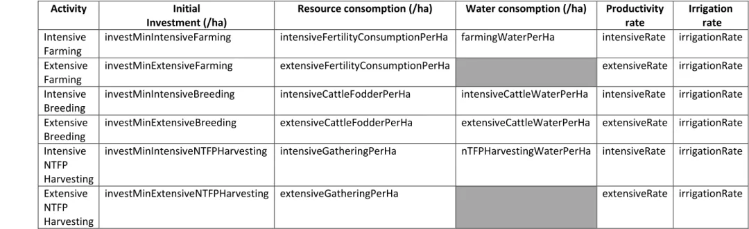
Table 1: attributes for the calculation of a rural activity cost and level of production
Activity Initial
Investment (/ha)
Resource consomption (/ha) Water consomption (/ha) Productivity rate
Irrigation rate
Intensive Farming
investMinIntensiveFarming intensiveFertilityConsumptionPerHa farmingWaterPerHa intensiveRate irrigationRate Extensive
Farming
investMinExtensiveFarming extensiveFertilityConsumptionPerHa extensiveRate irrigationRate Intensive
Breeding
investMinIntensiveBreeding intensiveCattleFodderPerHa intensiveCattleWaterPerHa intensiveRate irrigationRate Extensive
Breeding
investMinExtensiveBreeding extensiveCattleFodderPerHa extensiveCattleWaterPerHa extensiveRate irrigationRate Intensive
NTFP Harvesting
investMinIntensiveNTFPHarvesting intensiveGatheringPerHa nTFPHarvestingWaterPerHa intensiveRate irrigationRate
Extensive NTFP Harvesting
investMinExtensiveNTFPHarvesting extensiveGatheringPerHa extensiveRate irrigationRate
For example, if a user realizes an activity of intensive farming on 3 hectares of a land plot, he will initially deduct from his attribute “capital” the value [investMinIntensiveFarming * 3]. He will consume the value: [3* intensiveFertilityConsumptionPerHa] of the fertility of the land plot. If he realizes this intensive farming with a water supply, he will also consume the value: [3*farmingWaterPerHa] of the water of the water source for which he has obtained a water access right. His final production will be equal to: [3* intensiveFertilityConsumptionPerHa * intensiveRate * irrigation Rate], and will be added to his attribute “capital” at the end of the simulation step.
The agent-based model take into account the potential gap between this “ideal”, theoretical scenario of activity and the current state of natural resource and water availability. If the quantity of resource on the land plot or on the water source is lower than the user’ expectations, he will consume the maximum available at the time of his activity, and his production level will be adapted (and reduced) in consequence.
11
c. Social entities
Regulators
From the sub-class Regulator, the agent-based model considers 3 possible classes of regulator agents, corresponding to 3 sources of regulation existing within the pluralism of land regulations for securing access to resources:
- the land chief agents, representing the weight of tradition,
- the local community agents, representing the decentralization policy, - the state agent (central as regionalized).
These regulators represent different rules and laws which exist, or have existed, but which in any case make sense for the users who decide to mobilize them. According to the scenarios the modeler decides to explore, it is possible to introduce into the model up to all of these potential sources of land regulation.
Each regulator agent (Land Chief, Local Community and State) possesses an attribute “resourcesUnderMyRegulation” representing the set of land plots on which he has an administration right. He knows the total size of his territory through the attribute “sizeOfterritory” (equal to the adding of the number of hectares of each land plot of his attribute “resourcesUnderMyRegulation”). For land chief agents, it represents their respective land territories (land plots are linked to their land chief regulator agent through their attribute landChiefTerritory), and for local community agents the decentralized territories they are mandated to manage (land plots are linked to their local community regulator agent through their attribute localCommunity). For the state agent (only one agent of this type created), he always manages the whole territory, known as the state domain (the State knows and is linked to all the land plot of the agent-based model environment, through their attribute “stateplot”). Different regulator agents can have the same land plot to manage on their respective territories, in order to illustrate the overlap of land regulation systems.
Each regulator agent has an attribute “communityOfUsers” allowing him to know the user agents that are part of his landChiefTerritory (if the regulator is a land Chief), his local community (if the regulator is a local Community) or his state domain (if the regulator is the state). As same as for the land plots, the state regulator agent knows all the users of the agent-based model environment, and a same user is attached to a landChiefterritory and to a localCommunity (and to the State) at the same time. Each regulator agent has an attribute “logic of action” defining the logic he will follow to distribute resource access rights on the land plots he manage. This attribute can take the value: #economic, #social, #enviroConserv or #enviroResto according to the objective the regulator agent prioritizes (see Table 2).
12
Table 2: synopsis of the regulator different logics of action
Objective
Logic of action
#economic The focus for allocating resource access rights is here made on users’ capital, regulator agents favoring requests of the users with the highest capital
#social The focus for allocating resource access rights is here made on users themselves. A regulator agent following this logic will adapt his access authorizations to the assurance that all the users of his territory have at least one resource access right
#enviroConserv The focus for allocating resource access rights is here made on the conservation of resources environmental state. A regulator agent following this logic will close the access to the land plots of his territory where the state of the resources is the best to optimize their environmental durability
#enviroResto The focus for allocating resource access rights is here made on the restauration of resources environmental state. A regulator agent following this logic will close the access to the land plots of his territory where the state of the resources is the worst, to allow their fastest and better reconstruction.
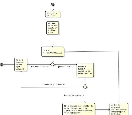
Endowed with his own logic of action, each regulator agent manages for every season the resource access rights on the land plots of his territory (see Figure 3). When a regulator agent finally decides to give a resource access right on a land plot to a user agent, he gives him an OrderedCollection composed of:
Detail of a resource access right:
#social
#economic
#enviroConserv
#enviroResto
A nature of resource access right
Randomly chooses between #rightToUse and #rightToInvestInTheUse.
The agent-based model focuses on these two levels of the bundles of rights because it represents two forms of space appropriation already highly differentiated, which impact the decision of investment for the users
A surface, in hectares,
localized on one or several land plot(s)
Equal to the value of the attribute “SocialOptimalSize”
Equal to the value of the user request
Equel to the value of the attribute “EnviroOptimalSize”
A period Randomly chooses between: #drySeason, #rainySeason and #annual
A duration Randomly chooses between a range of duration (from the season up to several years)
A access price Equal to the value of the regulator attribute “rentingPriceCommunity”
Note here that when user agents make land right requests to regulator agents, they ask for a defined land plot, a defined surface and a defined nature of access right, resulting from the choice of activity they are planning to realize. All the user requests are collect and known by a regulator agent through his attribute “usersRequests”. According to their own logics of action, regulators will choose to follow the users wishes, or decide themselves which land plot will be allocate, for which surface, which period, duration, and for what purpose (to use only, or right to invest in the use). All the resource access rights delivered by a regulator agent are kept in his attribute: “accessRightsDelivered”.
13
Figure 3: activity diagram for a land regulator and details of its different logics of action according to the objective he prioritizes
Choice of logic of action
Decide on a unit value (/ha) for his attribute “rentingPriceCommunity” Estimate an optimal quantity of land to allocate Look for resourceUserRequest Look for an available land plot
#social Allocates only free lending SocialOptimalsize = (regulator territory size) / (number of users requests)
Selects a user from a social ranking of the
user requests, prioritizing in the first part the ones with no
(or few) resource access rights
Considers all the land plots of his territory for which the attribute availableHa >0 #economic Randomly chooses between a range of unit
prices
Follows the users wishes in their
requests
Selects a user from a wealth ranking of the
user requests prioritizing in the first
part the ones with a high amount of
capital
#enviroConserv EnviroOptimalSize
= (Number of land plots with low
fertility) / (Number of user
of the regulator community)
Selects randomly a user from the user
requests Considers only the land plots with low fertility and with
14
availableHa > 0
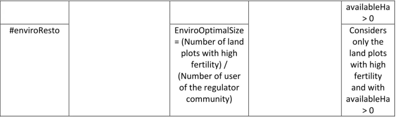
#enviroResto EnviroOptimalSize
= (Number of land plots with high
fertility) / (Number of user of the regulator community) Considers only the land plots with high fertility and with availableHa > 0 Water Regulators
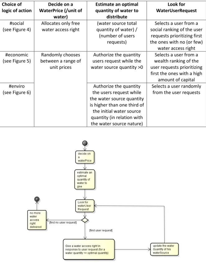
Each water regulator agent created in the agent-based model has in management one water source (well or drilling) known through his attribute “WaterSourceUnderRegulation”. As same as for the land regulators, he regulates for every season the water access rights on his water source, endowed with his own logic of action (see Table 3).
Table 3: synopsis of the water regulator different logics of action
Value of the
attribute
Logic of action
#economic The focus for allocating water access rights is here made on users’ capital, regulators favoring requests of the users with the highest capital
#social The focus for allocating water access rights is here made on users themselves. A regulator following this logic will adapt his access authorizations to the assurance that all the users who have requested a water access from his water source have at least one water access right
#enviro The focus for allocating water access rights is here made on water environmental state. The regulator following this logic will close the access to his water source when the water level goes below a certain environmental level.
When a water regulator agent decides to distributed a water access right to his water source, this access right is constituted:
- of a certain quantity of water, representing what the user is allowed to take, and define according to the water regulator logic of action;
- for a duration: define by the water regulator attribute “waterRightDuration”
- at a certain cost, known through the water regulator attribute “waterPrice” and defined by the water regulators according to his logic of action.
As with land regulators, when user agents make water right requests to water regulator agents, they ask for a defined water quantity resulting from the choice of activity they are planning to realize. These requests are collect through the water regulator attribute “userWaterRequests”. According to their own logics of action, water regulators will choose to follow the users’ wishes, or decide themselves which water quantity they allow. All the water access rights delivered by a water regulator agent are kept in his attribute: “waterAccessRightsDelivered”.
For both steps, water regulator agents do a succession of actions for distributing water access rights on their water sources, the conditions linked to the realization of these actions depending on the logics they choose to follow (see Table 4).
15
Table 4: activity diagram for a water regulator and details of its different logics of action according to the objective he prioritizes Choice of logic of action Decide on a WaterPrice (/unit of water) Estimate an optimal quantity of water to distribute Look for WaterUserRequest #social (see Figure 4)
Allocates only free water access right
(water source total quantity of water) / (number of users
requests)
Selects a user from a social ranking of the user
requests prioritizing first the ones with no (or few)
water access right #economic
(see Figure 5)
Randomly chooses between a range of
unit prices
Authorize the quantity users request while the water source quantity >0
Selects a user from a wealth ranking of the user requests prioritizing first the ones with a high
amount of capital #enviro
(see Figure 6)
Authorize the quantity the users request while the water source quantity is higher than one third of the initial water source quantity (in relation with the water source nature)
Selects a user randomly from the user requests
16
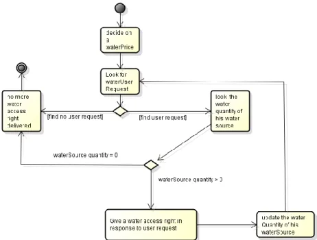
Figure 5: activity diagram for a water regulator prioritizing economic objectives
Figure 6: activity diagramm of a water regulator prioritizing environmental objectives
Users
In the agent-based model, three natures of user agent are represented: a rural family, a village or a group of villages, according to the scale analysis of the pluralism of land regulation that the modeler wants to explore. According to his nature, a user agent will have more or less important values of his attributes “collectiveMembers”, “foodSelfSufficiencyThreshold” and “capital” (this attribute symbolizes the gathering of the physical capital, the human capital and the financial capital). User
17
agents created are initially randomly localized in the model environment, and by doing so attached to a land territory (linked to a land Chief agent through their attribute “landChiefTerritory”), a local community (linked to a local community agent through their attribute “localCommunity”), and to the state domain (the state agent knows all the users).
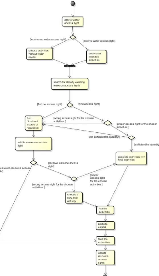
At the beginning of the dry and the rainy seasons (see Figures 7 and 8), user agents start by choosing a first potential activity to realize according to their capital. To do so, they look on their attribute “libraryOfActivities” to select the most intensive activity they can realize (by comparing the different values of initial investment per ha of the activities of the Library with the value of their own capital). Then, they ask (if necessary to their activity) for water access rights to the regulator of the water sources they perceive. To do so, they look around them according to their individual value of attribute “perceptionOfResourceRegulation” (it defines the extent of the water sources they consider) where are the water sources which the higher quantity of water, and they send a request to each of the water regulator linked to the concerned water sources. Requests of a user agent are collect through his attribute “waterAccessRightRequests”. Responses from the water regulators (according to their own logics of action) are available through the user attribute “waterAccessRights”. According to these responses, user agents will maintain their first choice of activity, or opt for a new one which does not require a water supply (this action is possible only during the rainy season, otherwise a user agent with no water access rights is not able to realize any rural activity). To do so, they look on their attribute “libraryOfActivitiesNoWater”.
The choice of activity will lead to a need of a certain number of hectares to realize it (known by the attribute “hectaresNeeded”). This number of hectares is calculated in the agent-based model from the operation: [capital of the user / (initial investment per ha of the chosen activity)]. A user agent always begins by consulting his portfolio of resource access rights (through his attribute “resourceAccessRights”), to know (1) if he already possess available resource access rights, and (2) if these rights are suited and/or sufficient (in term of number of hectares for example, or of nature of access right) with regard to the activity he decided to realize. If his portfolio of resource access rights is empty, unsuitable or simply insufficient, the user agent is going to ask for a new resource access right and by doing so enter in interaction with a source of land regulation.
According to the nature of the chosen activity, a need to reach the natural resources (fertility for farming, NTFP for harvesting, fodder for breeding) is necessary. Users ask for this access to the regulators who manage the resources they request. To do so, they look around them according to the individual value of their attribute “perceptionOfResourceRegulation” (it defines the extent of the land plots they consider) where are the resources with the higher quantity and they send a request to the prevalent land regulator linked to each land plot they have found. This prevalence is known through a ranking by the user agent of the values of the land plot attributes: “Land Chief Regulation”, “Local Community Regulation”, “State Regulation” and “Other User Regulation”. This action symbolizes the fact that a user who wants to access a resource will base his decision on the ways the other users that already exploit the spaces which interest him have obtained their own access rights. If no prevalent source of regulation emerges from the land plot the user agent needs to access, he will by default consider asking for his access right to the land chief agent of the land plot considered. All the requests of a user agent to land regulators are collect through his attribute “resourceAccessRightRequests”. According to the sources of land regulation mobilized and to the return (favorable or unfavorable) of the land regulators, the user agent find himself with a updated portfolio of resource access rights that will condition his final activity decision and the consumption of natural resources that results. For example, all user agents respect the rule about what the nature of the access right allows them to
18
realize. Intensive activities requiring consequent initial investment are considered only by users with rights to invest in the use. Thus if at the end of the interactions with regulators the users find themselves with simple rights to use, they will reconsider their choices to opt for extensive activities (by looking on their attribute “libraryOfExtensiveActivities”). If a right to invest in the use is obtained, user agents will base their final decisions of investment on their attribute “perceptionOfAccessRightDuration”, specific to each user agent. For any right to invest in the use, if the duration of the access right delivered by the regulator goes below the value of this perception of access right duration, the user will consider the act of investment too risky, and will opt for extensive activities.
Part of the production serves to satisfy the food needs of the family, the village or the group of villages (according to the nature of the user agent), and the potential surplus is put back in the user capital for the following step, or season. At the end of each season, user agents update their portfolio of resource access rights, by removing the rights for which the duration reaches its end.
The last source of land regulation considered in the agent-based model is the inter-users regulation. If a user has available hectares to share on his land plot(s) (only for the ones for which the obtained access is a right to invest in the use), he can allow access to it to the other users, becoming by doing so a regulator. To do so, each user agent possessing rights to invest in the use will compare his own need of hectares (through the value of his attribute “hectaresNeeded”) with the total number of hectares proposed with his land right. If his need of hectares is lower than the total available number of hectares, he will propose the complement to other user agents through his attribute “accessRightAvailableToShare”. All the requests from the other users are collect into the attribute “otherUserRequests”.
User-regulators follow the same logics of action as other regulators to define their access permission, they can choose between: #economic, #social, #enviroConserv and #enviroResto (known through the user attribute “logicOfRegulatorAction”). These logics symbolize the various manners to make land circulate between users, through lend (free access), rent (paying access), or through fallow dynamics (close the access to allow the fertility of the land to regenerate) (see Table 5).
19
20
21
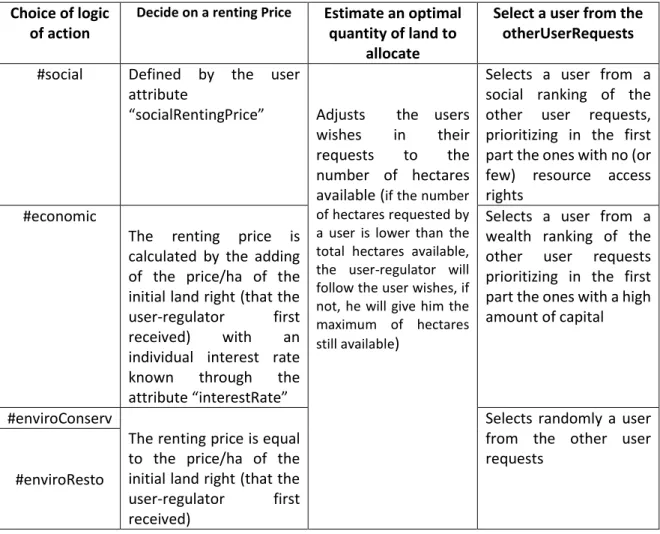
Table 5: details of a user-regulator different logics of action according to the objective he prioritizes
Choice of logic of action
Decide on a renting Price Estimate an optimal
quantity of land to allocate
Select a user from the otherUserRequests
#social Defined by the user attribute
“socialRentingPrice” Adjusts the users wishes in their requests to the number of hectares available (if the number of hectares requested by a user is lower than the total hectares available, the user-regulator will follow the user wishes, if not, he will give him the maximum of hectares still available)
Selects a user from a social ranking of the other user requests, prioritizing in the first part the ones with no (or few) resource access rights
#economic
The renting price is calculated by the adding of the price/ha of the initial land right (that the user-regulator first received) with an individual interest rate known through the attribute “interestRate”
Selects a user from a wealth ranking of the other user requests prioritizing in the first part the ones with a high amount of capital
#enviroConserv
The renting price is equal to the price/ha of the initial land right (that the user-regulator first received)
Selects randomly a user from the other user requests
#enviroResto
When a user-regulator agent decides to give a resource access right to another user, the access right is constituted of the same elements as for the other regulators, but the access right is on his own land plot(s), and the duration is only for one step (a seasonal access right). All the land rights distributed by a user-regulator to other users are collect through his attribute “accessRightDeliveredToUsers”.
d. Dynamics of the agent-based model
Agro-ecological dynamics
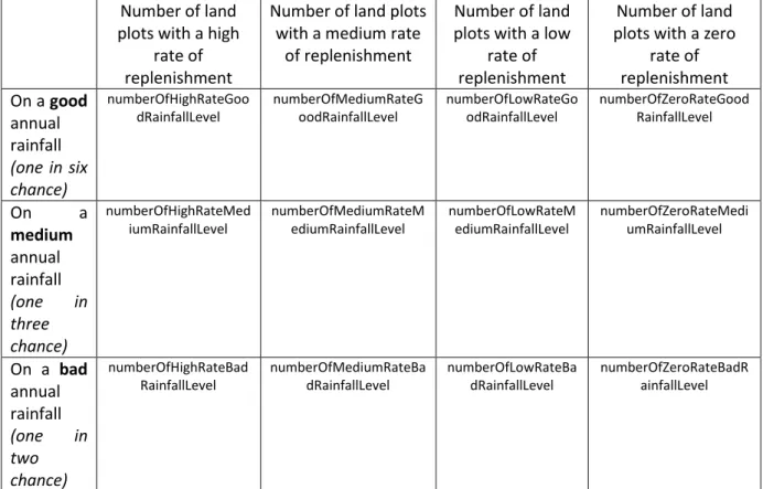
Natural resource replenishment is linked to the annual rainfall, which is based on the Sahelian concepts of high variability and uncertainty regarding natural resources evolution and availability. In addition to the nature of the environment, the quality (good, medium or bad) of the rainfall has an impact on the environmental state of fertility, fodder, and NTFP on each land plot.
At the beginning of each rainy season, the agent-based model randomly chooses the quality of the rainfall (defining the value of its class attribute rainfallLevel: #good #medium #bad) with a respective probability of 1/6 for the good rainfall, 1/3 for the medium rainfall and ½ for the bad rainfall. According to the quality of this rainfall, the number of land plots for which the natural resource are totally (highRate attribute) or partially (mediumRate: 50%, lowRate: 25%, or zeroRate: 0% of replenishment)
22
replenished will vary (see Table 6). The rate of replenishment is based on the initial quantity of natural resources which differ according to the land type of the land plot (attribute lowlandSoilPerHaInit”, “degradedSoilPerHaInit” or “sandySoilperHaInit).
For example, if the rainy season is a good annual rainfall, the agent-based model will randomly select: - numberOfHighRateGoodRainfallLevel land plots for which, according to their land type, the quantity of each natural resource (fertility, fodder, NTFP) will be recovered with a high rate of 100% of their initial value;
- numberOfMediumRateGoodRainfallLevel land plots for which, according to their land type, the quantity of each natural resource will be recovered with a medium rate of 50% of their initial value;
- numberOfLowRateGoodRainfallLevel land plots for which, according to their land type, the quantity of each natural resource will be recovered with a low rate of 25% of their initial value; - numberOfZeroRateGoodRainfallLevel land plots for which the quantity of each natural
resource will not be recovered.
Table 6: Attributes for the number of land plots served by each level of rainfall according to the quality of the annual rainfall
Number of land plots with a high
rate of replenishment
Number of land plots with a medium rate
of replenishment
Number of land plots with a low
rate of replenishment
Number of land plots with a zero
rate of replenishment On a good annual rainfall (one in six chance) numberOfHighRateGoo dRainfallLevel numberOfMediumRateG oodRainfallLevel numberOfLowRateGo odRainfallLevel numberOfZeroRateGood RainfallLevel On a medium annual rainfall (one in three chance) numberOfHighRateMed iumRainfallLevel numberOfMediumRateM ediumRainfallLevel numberOfLowRateM ediumRainfallLevel numberOfZeroRateMedi umRainfallLevel On a bad annual rainfall (one in two chance) numberOfHighRateBad RainfallLevel numberOfMediumRateBa dRainfallLevel numberOfLowRateBa dRainfallLevel numberOfZeroRateBadR ainfallLevel Land dynamics
Each regulator agent manages a more or less wide territory, on which he distributes at each season resource access rights. During the step, each time a regulator give a resource access right to a user on a certain plot, for a certain surface (ha) and a certain duration, these surface is subtracted from the value of the attribute “available Hectares” of the concerned land plot and the concerned land regulator
23
for all the duration of the resource access right. For example, if a user receives from the state agent a right to use on 10 hectares for 8 seasons at a spatial scale of 50 hectares for the land plot area, the attribute “availableHaState” takes the value 50-10 = 40 hectares for the next 8 step. At the end of the 8th step, the 10 hectares are re-injected on the value of the attribute availableHaState of the land plot,
and therefore made available again for the users for future requests.
Note here that this dynamic does not apply to user-regulator agents because they necessarily distribute a seasonal resource access rights which lasts only one step. They indeed decide at each beginning of step if they are going to exploit by themselves their land plot(s), or if they will partially or entirely make these surfaces available to the other user requests. The surfaces exploit through free lend or rent by other users are therefore re-injected to the user-regulators land capital at each end of step.
During the simulation, according to the sources of land regulation the modeler decides or not to introduce, the mobilization of these sources of regulation by the users will potentially evolve, and this will impact the evolution of the number of available hectares of each land regulation sources on the land plots. This dynamic represents in the agent-based model the overlap of land regulation sources. It develops the fact that several users can ask for an access right to the same space and for the same resource, according to the source of regulation they choose to mobilize. We will potentially find in the agent-based model four user agents trying to exploit the resources of the same surface on the same land plot, given for one by a land chief agent, for another by a local community agent, for a third by a user-regulator and for the last one by the state agent.
The agent-based model voluntary does not go beyond this problematic statement. It does not choose if and if so which land regulation source is more important (i.e. which user get to exploit the resources in the end), it is only highlight the overlap, and let the model randomly decides itself.
3. : INITIALISATION OF THE ABM SIMULATIONS
i.
Calibration of the simulation
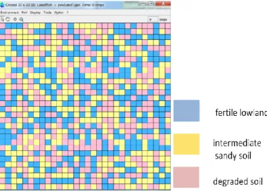
The environment of the agent-based model is composed of 900 land plots. This proportion is fixed (1) in order to authorize the representation of different general spatial scales (according to the value of the land plot area) and (2) in order to control the number of land plot of each land type created, through the class model attributes: numberOfLowLandSoil, numberOfDegradedSoil and numberOfSandySoil. For my set of simulation, the proportion of each land type is equal (300 of each). The lowlands (blue), the intermediary sandy areas (cream) and the degraded lands (pink) are randomly distributed within the environment (see Figure 9), in order to highlight the variability of this Sahelian environment.
Each land plot contains a set of attributes on natural resources: fertility, fodder, and non-timber forest products (NTFP). The initial quantity of each resource is equal to 5 units per hectare if the land plot is a lowland soil, 2 units per hectare if it is a sandy soil and 1 unit per hectare if it is a degraded soil. The total quantity of each natural resource is calculated with regards to the area of the land plot.
24
Figure 9: Environment of the agent-based model
In this regard, three choices of initialization exist in the agent-based model, linked to the three possible values of land plot area (see Table 7). If the modeler chooses the INIT A, all the land plot of the environment will have their attribute landPlotArea equal to 1, if he chooses INIT B equal to 50 and if he chooses INIT C equal to 1000. It is not possible during the same simulation to have at the same time a land plot area equal to 1 and another equal to 1000. The idea is that the general landscape represents different
Table 7: three choices of initialization for three space scale representations
Initialization Land plot Area Total Area of the environment Nature of the landscape
INIT A 1 hectare 900 ha / 9 km2 a village territory
INIT B 50 hectares 45 000 ha / 450 km2 a set of local
communities
INIT C 1000 hectares 900 000 ha / 9000 km2 a region
Consequently to these three possible choices of Initialization, the number of social and passive entities will also vary (see Table 8).
Table 8: calibration of the three initializations
Initialization Land plot Area Number of State agent Number of Local Community agent Number of Land Chief agent
Number of User agent
INIT A 1 ha 1 1 5 200
(family level)
INIT B 50 ha 1 5 20 1000
(village level)
INIT C 1000 ha 1 20 56 1000
(group of villages level) For the particular case of user agents, the equivalence between the space scales is linked to the fact that a user agent does not represent the same social entity at the three scales. The coherence is founded through the combination of the number of user agent created and the value of their attributes collectiveMembers and capital (see Figure 10).
25
Figure 10: equivalence of user agent number and attributes according to the choice of space scale
For the INIT A, user agents represent rural families, evolving on the general landscape of a village territory. Every user agent represents a more or less important family: the size of the family known with the attribute “collective members” is randomly initially defined by the agent-based model between a minFamilyMember and a maxFamilyMember attributes, varying from ten to twenty from one user agent to another. This defines consequently the food self-sufficiency threshold to reach for each family. Each user agent has also an attribute “capital”, which symbolizes the gathering of the physical capital, the human capital and the financial capital. The initial value of this capital is randomly defined according to the size of the family: for one user agent, each member of the family has an individual capital value chosen randomly among the values: # (1 5 10 20 50 100 500), and the final initial capital of the user agent is the sum of this various individual capital. The idea is to represent the diversity of production means that different Sahelian rural families can possess.
For the INIT B, user agents represent this time villages (as grouping of several families) evolving on a global landscape equivalent to a set of local communities. For the INIT C, user agents represent groups of several villages, evolving on a global landscape similar to a region. The equivalences in terms of number of user agents created (and of the collective members of each user agent) have been estimated regarding the change of land plot area from one initialization to another. The initialization of the attribute capital for the init B and C follows the same principle as for the init A.
The perception of land tenure security is specific to each user agent, and defined in the agent-based model through the values of the attributes “perceptionOfAccessRightDuration” and “perceptionOfResourceRegulation”. The “perception of access right duration” is varying from 2 up to 10, the value is randomly initially fixed. As a reminder, for any right to invest in the use, if the duration of the access right delivered by the regulator goes below this perception of access right duration, the user will consider the act of investment too risky, and will opt for extensive activities.
The “perception of resources and their regulation(s)” is varying from 1 up to 30 for the INIT A, and from 1 up to 15 for the INIT B and C, and the value is also randomly initially fixed. This reflects the idea that the level of information that land actors possess about land regulations strongly vary from one user to another, some of them have a perception that only extend on their village, or their land territory
26
whereas others will know what is happening in the all country (i.e. the total environment of the agent-based model) (see Figure 11). As a reminder, user agents mobilize this attribute when they look for available land plots which possess the resources they need, it defines the extent of the land plots they consider. The same attribute is used when user agents look for water sources and send water requests to the water regulators of the water sources they found.
Figure 11: Illustration of the diversity of the levels of perception, reflecting the level of information of the agent user. Level of perception of the lower left user: 2; level of perception of the upper right user: 10. The environment represents
the different land territories of the land chief agents
At last, according to the amount of capital they possess, the characteristics of their land access rights, the fact that they can access water or not, user agents can have up to 6 possible choices of rural activity, more or less intensive (see Table 9).
27
Table 9: calibration of the values of the attributes of the activity passive entities according to the nature of the activity
Activity Initial Investment (/ha) Resource consomption (/ha) Water consomption (/ha) Productivity rate Irrigation rate Intensive farming 50 500 500 10 5 Extensive farming 2 20 2 Intensive breeding 120 1000 1000 10 Extensive breeding 6 60 60 2 Intensive NTFP harvesting 20 250 250 10 5 Extensive NTFP harvesting 1 10 2
The environment of the model is divided for each type of regulator agent (Land Chief, Local Community and State) in more or less territories according to the type of agent and the choice of Initialization (see Figure 12). For land chief agents, it represents their respective land territories, and for local community agents the decentralized territories they are mandated to manage. For the state agent (only one agent of this type created no matter the choice of Initialization), he always manages the whole territory (known as the state domain).
According to the choice of initialization made, the number of each type of water source (and the number of water regulator agents in consequence), as well as the quantity of water they contain will also not be the same:
Initializ ation
Number of ponds
Number of
wells
Number of drillings
Good rainfall Medium rainfall Badrainfall
INIT A 6 3 2 8 1
Water initial quantity : 100 units Water initial quantity : 200
units
Water initial quantity : 50 000 units
INIT B 30 15 10 100 30
Water initial quantity : 1000 units Water initial quantity : 10 000 units
Water initial quantity : 50 000 units
INIT C
X
X
260Water initial quantity : 200 000 units These water sources are initially (for the well and the drillings) of at each beginning of rainy season (for the pounds) randomly localized in the environment (see Figure 13).
28