HAL Id: hal-02798098
https://hal.inrae.fr/hal-02798098
Submitted on 5 Jun 2020HAL is a multi-disciplinary open access archive for the deposit and dissemination of sci-entific research documents, whether they are pub-lished or not. The documents may come from teaching and research institutions in France or abroad, or from public or private research centers.
L’archive ouverte pluridisciplinaire HAL, est destinée au dépôt et à la diffusion de documents scientifiques de niveau recherche, publiés ou non, émanant des établissements d’enseignement et de recherche français ou étrangers, des laboratoires publics ou privés.
Task 2, Activities a) b) c) d)
Manuel Arriaza, Tufan Bal, Petar Borisov, M. Cagla, Stefania Czekaj,
Laurence Delattre, Giuliano Galimberti, Renata Giedych, Kati Häfner, F.
Handan Giray, et al.
To cite this version:
Manuel Arriaza, Tufan Bal, Petar Borisov, M. Cagla, Stefania Czekaj, et al.. Deliverable D4.20, Part 1 - Summary report on WP4 Task 2, Activities a) b) c) d). [Contract] 2014. �hal-02798098�
]
Project no. 289578
Claim
Supporting the role of the Common agricultural policy in Landscape valorisation: Improving
the knowledge base of the contribution of landscape Management to the rural economy
Call identifier: FP7‐KBBE.2011.1.4‐04
Funding scheme: Collaborative project
Part 1
Summary report on WP4 Task 2, Activities a) b) c) d)
Deliverable D4.20
First draft: 28.02.2014
Final version: 01.04.2014
Start date of project: 01 January 2012
Duration: 36 months
Organisation name of lead beneficiary for this deliverable: BOKU
[authors see page 2]
Vienna, 01.04.2014
Project funded by the European Commission within the Seventh Framework Programme (2007‐ 2013) Dissemination Level PU Public X PP Restricted to other programme participants (Including the Commission Services) RE Restricted to a group specified by the consortium (Including the Commission Services) CO Confidential, only for members of the consortium (Including the Commission Services)CLAIM Project:
Organisation Short Country
ALMA MATER STUDIORUM‐UNIVERSITA DI BOLOGNA (Coordinator) UNIBO Italy
LEIBNIZ‐ZENTRUM FUER AGRARLANDSCHAFTSFORSCHUNG ZALF Germany
JOINT RESEARCH CENTRE‐ EUROPEAN COMMISSION ‐ Institute for
prospective technological studies JRC – IPTS Spain
UNIVERSITAET FUER BODENKULTUR WIEN BOKU Austria
VERENIGING VOOR CHRISTELIJK HOGER ONDERWIJS
WETENSCHAPPELIJK ONDERZOEK EN PATIENTENZORG VU‐IVM Netherlands
INSTITUTO ANDALUZ DE INVESTIGACIONY FORMACION AGRARIA
PESQUERA ALIMENTARIA Y DE LA PRODUCCIONECOLOGICA IFAPA Spain
WARSAW AGRICULTURAL UNIVERSITY WAU Poland
SULEYMAN DEMIREL UNIVERSITY SDU Turkey
AGRICULTURAL UNIVERSITY AU Bulgaria
INSTITUT NATIONAL DE LA RECHERCHEAGRONOMIQUE INRA France
Authors of D 4.20 ‐ Part 1:
UNIBO: Stefano Targetti, Rosa Manrique, Giuliano Galimberti, Meri Raggi, Matteo Zavalloni, Davide Viaggi ZALF: Fabrizio Ungaro, Ingo Zasada, Kati Häfner, Annette Piorr BOKU: Lena Schaller, Martin Kapfer, Jochen Kantelhardt VU‐IVM: Boris van Zanten, Peter Verburg IFAPA: Manuel Arriaza WAU: Edward Majewski, Agata Malak‐Rawlikowska, Paweł Kobus, Adam Wąs, PrzemysławWolski, Barbara Szulczewska, Renata Giedych, Gabriela Maksymiuk, Stefania Czekaj SDU: F. Handan Giray, Tufan Bal, M. Cagla Ormeci Kart AU: Dimitre Nikolov, Teodor Radev, Petar Borisov INRA: L. Delattre, F. Guéniot, L. Leonelli, M. Mouléry, C. Napoléone, J.C. Paoli, P. Santucci.Introduction to CLAIM D.4.20, Part 1:
The summary report on WP4 Task 2, Activities a) b) c) d)
Part 1 of D4.20 represents the summary report on case study activities apart from the ad‐hoc studies. This case study summary report shows how the empirical evidence collected in the overall WP4 activities directly supports the development of the CLAIM framework. At this, the case study summary report in particular addresses the 5 guiding questions of the project in the context of the single CSAs by summarising the overall considerations of Activity a) and Activity b) plus further discussions that took place during WP4 apart from the ad‐hoc studies. The summary reports are organised country by country and all include the following sections:‐
Description of CSA region‐
Agrarian landscape and socio‐economic development‐
Landscape as a driver of competitiveness‐
Mechanisms‐
Role of the CAP‐
Methods‐
Summary and OutlookContents of D4.20 – Part 1
1 CSA1: The Eastern Ferrara lowlands, Italy ... 6 1.1 Description of CSA1 region ... 6 1.2 Agrarian landscape and socio‐economic development ... 6 1.3 Landscape as a driver of competitiveness ... 8 1.4 Mechanisms... 10 1.5 Role of the CAP ... 11 1.6 Methods ... 12 1.7 Summary and outlook ... 14 2 CSA2: Märkische Schweiz, Germany ... 15 2.1 Description of CSA2 region ... 15 2.2 Agrarian landscape and socio‐economic development ... 16 2.3 Landscape as a driver of competitiveness ... 18 2.4 Mechanisms... 20 2.5 Role of the CAP ... 22 2.6 Methods ... 24 2.7 Summary and outlook ... 25 3 CSA3: Mittleres Ennstal, Styria, Austria ... 28 3.1 Description of CSA3 region ... 28 3.2 Agrarian landscape and socio‐economic development ... 29 3.3 Landscape as a driver of competitiveness ... 33 3.4 Mechanisms... 35 3.5 Role of the CAP ... 38 3.6 Methods ... 41 3.7 Summary and outlook ... 43 4 CSA4: Winterswijk Municipality, Netherlands ... 46 4.1 Description of CSA4 region ... 46 4.2 Agrarian landscape and socio‐economic development ... 47 4.3 Landscape as a driver of competitiveness ... 49 4.4 Mechanisms... 50 4.5 Role of the CAP ... 51 4.6 Methods ... 53 4.7 Summary and Outlook ... 53 5 CSA5: Montoro, Spain ... 55 5.1 Description of CSA5 region ... 55 5.2 Agrarian landscape and socio‐economic development ... 565.3 Landscape as a driver of competitiveness ... 56 5.4 Mechanisms... 57 5.5 Role of the CAP ... 58 5.6 Methods ... 59 5.7 Summary and outlook: ... 60 6 CSA6: Chlapowski Landscape Park, Poland ... 61 6.1 Description of CSA6 region ... 61 6.2 Agrarian landscape and socio‐economic development ... 62 6.3 Landscape as a driver of competitiveness ... 64 6.4 Mechanisms... 65 6.5 Role of the CAP ... 67 6.6 Methods ... 69 6.7 Summary and outlook: ... 74 7 CSA7: Guneykent, Isparta, Turkey ... 75 7.1 Description of CSA7 region ... 75 7.2 Agrarian landscape and socio‐economic development ... 75 7.3 Landscape as a driver of competitiveness ... 79 7.4 Role of the CAP and Mechanisms ... 79 7.5 Methods ... 82 7.6 Summary and outlook ... 82 8 CSA8: Pazardzhik Region, Bulgaria ... 84 8.1 Description of CSA8 region ... 84 8.2 Agrarian landscape and socio‐economic development ... 84 8.3 Landscape as a driver of competitiveness ... 86 8.4 Mechanisms... 87 8.5 Role of the CAP ... 88 8.6 Methods ... 98 8.7 Summary and outlook ... 99 9 CSA9: Corse, France ... 101 9.1 Description of CSA9 region ... 101 9.2 Agrarian landscape and socio‐economic development ... 102 9.3 Landscape as a driver of competitiveness ... 104 9.4 Mechanisms... 104 9.5 Role of the CAP ... 105 9.6 Methods ... 107 9.7 Summary and outlook ... 107
1 CSA1: The Eastern Ferrara lowlands, Italy
Davide Viaggi, Meri Raggi, Giuliano Galimberti, Rosa Manrique, Stefano Targetti, Matteo Zavalloni (UNIBO)1.1 Description of CSA1 region
The study area is located in the eastern side of the Region Emilia‐Romagna, province of Ferrara. It is the third agricultural region of Ferrara, which comprises 9 municipalities: Codigoro, Comacchio, Goro, Lagosanto, Massa Fiscaglia, Mesola, Migliaro and Migliarino. It is located in the Continental Biogeographic Region and in the Mediterranean North ecoregion. It is a plain area with a minimum elevation of 3m below sea level to a maximum of 8m above sea level. A large part of the territory is within the Po Delta Park, contains important Natura2000 sites and holds 25 km of sandy beaches. Land use has been highly influenced by the intensification of mechanization to improve agricultural production, replacing the typical landscape elements. Since the reclaimed lands have substituted the humid environments, the predominant landscape is composed by agriculture (74% of the study area) with a large extent of arable crops (59% of the UAA), small areas of wetlands and pine woods patches occupy ca. 15% of the study area, due to land reclamation and water management a large extension of embankments and water channels exist (4% of the study area). Land reclamation activities have increased agricultural production, and most important, have assured the stability and good hydraulic regime on declivous terrains, controlled the water drainage and maintained a good hydraulic conditions around the territory. Artificial areas (ca. 6%, urban areas, small villages) are characterised by their ancient history and the high presence of historic buildings.1.2 Agrarian landscape and socio‐economic development
1.2.1 Landscape management
Agriculture management is medium‐high intensive (12% of the total area is occupied by an average size of farms of 10‐20 ha, while 40% of the CSA is occupied by large dimension farms >100 ha), and mainly committed to (inter)national agri‐food supply chains. The regional Park aims to environment‐ friendly practices and re‐naturalization of specific areas (e.g. Mesola Wood). As the Lowlands are reclaimed areas, truly traditional agricultural practices do not exist. Projects and activities of the park administration affects the agricultural areas which are connected to different habitats protected by the park. In fact, changing the way to do agriculture could affect/improve the habitats. The main activities are related to habitat restoration and conservation, species protection habitat (especially birds), management of selected critical areas (e.g. salina di Comacchio, sacca di Goro), and the elaboration of development plans (e.g. for the historic center of Comacchio).The park has the potential to modify/improve the landscape through different projects (e.g. some initiatives have been the evaluation of the economic impact of climate change on agriculture, conservation of natural areas and valorization of local products, restoration of ecological areas as touristic attraction, restoration of forested areas, greening of farms to restore the traditional landscape). In general, agriculture activities into the park area are seen negatively, mainly because of the negative effect on water quality. However, at this time scarcely productive agriculture areas have been flooded again and reforested making use of the CAP incentives. Furthermore, thanks to this policy action the park is improving the change of agriculture to more sustainable direction, e.g. organic production.
Agriculture has been modified in several ways from the extent of surface used to the intensification of mechanization to improve production. Since reclaimed lands replaced the humid environments, agriculture has replaced the typical landscape elements (marshes, pine woods) with large extensions of embankments and water channels.
Land reclamation activities have influenced the CSA; most important, they currently assure the stability and good hydraulic regime, a correct water drainage and good hydraulic conditions of the territory, the adaptation and realization of reclamation, and assure the maintenance of the activities to protect and increment the surface water resources for agricultural use.
Local summer tourism is also an important market for horticultural farms (mainly placed on the beach side). Visits (mainly local) to the study area increase considerably during summer. During holidays time, the demand for beaches, the presence of areas of high naturalistic value, and the historical places have promoted an increment of receptive structures, rental houses, hotels, camping areas, beaches with restaurants, etc. This increment of land use has damaged the coastal line and threatened coastal habitats (e.g. dunes and coastal vegetation).
1.2.2 Landscape structure and elements
The Ferrara Lowlands are specifically characterized by the relationship between the human‐made agricultural fields (land reclamation) and the natural wetlands. The absence of viewpoints of this “flat” landscape generates a specific context with specific features in comparison to the other CLAIM case studies.
The intense land use of the territory have modified enormously the structure and composition of the landscape transforming the area from mainly wetlands to agricultural areas. In the case of BBNs study, in the particular case of agritourism, it was evidenced that the effect of policy incentives (e.g. measure 311) to impulse farm diversification, can actively beneficiate landscape due to the need of preserving natural elements (e.g. wetlands, green areas) and elements of cultural relevance (e.g. restoration of traditional buildings) to promote rural activities. Residents are aware of the importance of wetlands and seminatural vegetation, and even though this element has been considerably reduced, they consider their presence an advantage (see survey), contrarily to what has been evidenced by local stakeholders, who expressed a negative perception of wetlands relating them to mosquitos and source of diseases. This contradiction is clarified when it was specified that wetlands are considered an advantage because of the benefits they may generate in the territory linked to socio‐economic activities (e.g. tourism, festivals) and their support of other ES‐type, provisioning (e.g. typical products), regulation (e.g. water regulation), and supporting type (e.g. habitat).
1.2.3 Landscape functions and services
The study area context, is particularly important due to the services generated by the flow and interaction of different ES: provisioning, supporting, regulating and cultural.
Provisioning and regulating services are more directly linked to agricultural activities. Provisioning is the main output of agriculture, which depends largely on regulating services. On the contrary, cultural services have a weak link with agricultural landscapes. Traditional customs are mainly related to water channels (e.g. eel fishing). Services connected with the protection of human settlements (from floods and sea‐storm) are considered relevant. This was confirmed in the activity d) results. An example of potential positive links between landscape functions generated by landscape elements and consumers are focused by the agent based model.
Nevertheless, even though the agricultural landscape seems not to have a strong or direct link with cultural services, these services are highly dependent of landscape attractiveness, as has been shown in the case study of agritourism. Agritourism for example can be considered into a group of landscape‐related services, where the landscape is the main source of attributes to feed several activities (e.g. sportive, adventure, relax, etc.), which are supported by private beneficiaries. In the case study of BBNs, agritourism is highly sensitive to landscape attractiveness which is due to landscape composition and people’s perception of landscape elements. In our study area several activities related to the landscape context have developed: the presence of areas of high naturalistic value, and the historical places have promoted an increment of for example, receptive structures,
rental houses, hotels, camping areas. Beaches are the main attribute in the study area that capture most tourist, in particular during summer.
1.2.4 Landscape values and benefits
Natural elements like bogs and wetlands are perceived as “negative” by local residents, but are also a specific feature of the area that is well acknowledged and attract specific tourist types (naturalists, bird‐watchers) from other Italian regions. Nonetheless, more important and well developed tourism industry is related to the sea‐side tourism. Sea‐tourists do not attach specific values to the inner‐side agricultural landscape. The possibility to foster positive self‐sustainable feedbacks between landscape and economy was focused in the agent based model. Food production may be a “medium” to link awareness of potentialities of landscape valorization with local economy. Connection between agriculture and tourism is, however, weak. Information and the definition of a common policy strategy at different decision making levels seem essential. Potentials to connect the well developed beach tourism with the more naturalistic inner‐side tourism was highlighted by local stakeholders. This could lengthen tourism season and add peculiarities to the area. But facilities, infrastructures (e.g. bike routes) and awareness of local entrepreneurs should follow a common strategy.Analyzing the cause‐effect chain, in the case of agritourism, a positive perception of the landscape element influenced positively the landscape attractiveness of the study area. Wetlands and seminatural vegetation are considered an advantage among residents (69.5%), although this element is, at present, poorly represented (less than 10%). However, the consumers behavior revealed a low frequency of meals consumption in local agritourisms (data from the survey), which can be due to different reasons. It was highlighted, during our stakeholders laboratories (see deliverable 2.7) that residents of our study area are almost indifferent to landscape when referring to going to take meals outside, and that the main agritourism’s consumer is mainly urban, while residents who already live in a rural context are not susceptible to that activity because of cultural factors. In other areas, the use of agritourism by residents is, in turn, much higher, contrary to that evidenced in our study area. The residents behavior about agritourism consumption can be also explained by the recent agricultural history in the study area. The agritourism activity is relatively new, contrary to the more traditional, such as ‘trattoria’. The land where agritourism is emerging now are fairly recent due to the historical and depth transformation of the territory (i.e. land reclamation). Thus, the agritourism is considered a new element that it is not part of the cultural identity.
1.3 Landscape as a driver of competitiveness
The food production is highly specialized) mainly concentrated in cereals, orchards, and horticulture. In 2010 the UAA have increased (+11%) with respect to the 2000 agrarian census. Cereals is the main product of the study area, with a highly variable production in time but in increase, as well as vegetables. Fruits and legumes production remain almost invariant. Contrarily, the total surface of industrial crops production has decreased.In recent years, there has been a sharp increase in the number of Italian quality products (PDO, PGI, quality wines P.S.R, organic food), representing a high portion (more of 21%) of all Community products with designation of origin and gaining the first place in the EU (INEA 2008). In the CSA 2,283 ha practice organic production (4% of the UAA, 24 farms in 2010) and 18 farms produce PDO, PGI products.
The fishing sector is limited to the coastal areas, but is well developed in particular in the north east of the CSA (the station Volano‐Mesola‐Goro ) where this activity has not only an important economic value, but also historic and cultural. Fishing is predominant in Goro where the number of fishing workers are larger than in other activities (54%) (Piano di Sviluppo socio‐economico Volano –Mesola‐ Goro, 2005).
Tourism represents another important activity in the CSA, mainly because of the presence of the regional Po Delta park and the 25 km of coastal beaches. In 2010, 255 095 tourist (Italian and foreign)
have visited the CSA. For example, tourism is highly developed in Comacchio that benefitiates from the Po Delta Park and the presence of 7 bathing beaches. This area is plenty of touristic infrastructure (camping areas, restaurants, hotels, rental houses).The arrival of Italian tourist is higher than foreigners. Mostly, private activities (hotels, touristic rentals) capture the consumer arrivals.
Additional contribution to local competitiveness is given by additional gainful activities due to farms diversification, from which agritourism activities. Data from ISTAT for the period 2002‐2011 shows that the agritourism number in Ferrara has been triplicated, following the increase of the agritourism number in Italy (+67%). The growth trend of service supply is followed by the increase of agritourism use in Ferrara, which have increased in the last years (+39% and +45%, Italians and foreigners, respectively, source: ISTAT period 2009‐2011).
Agritourism contribute to local competitiveness improving job opportunities, as has been shown by Isola and Zuppiroli (2010) in the Region Emilia‐Romagna. The job opportunities are related to the management and recreational activities. In general, agritourism offers the client landscape‐related benefits such as the proximity of specific elements of the landscape (e.g. water bodies, historical and cultural heritage, green areas, sites of naturalistic importance, birds diversity), incorporating to its services other benefits such as the beauty of the place, the silence and relax, and the opportunity to do recreational activities.
Stakeholders of our study area are very concerned about the need of job opportunities in the study area, which was highlighted during the local meetings (see deliverables 2.6 and 2.7). There is a primarily vision concerning jobs creation and competitiveness. Stakeholders evidenced the highest value of food supply, it was highlighted that the main role of agriculture and farmers is food production, but also evidenced the need of different activities to support the creation and maintenance of jobs, local investment and the creation of added value. The discussion evidenced the need of linking specific landscape elements that may support economy in different ways: through the service management (e.g. ‘consorzio di bonifica’ water management) or through public (e.g. Po Delta park, cultural and recreation activities) and private service suppliers (e.g. agritourism).
Nevertheless, from the point of view of the stakeholders, entrepreneurship capacity is needed to maintain landscape. The quality of enterprises is important to create revenues and better landscape management. For example, bigger farms have more capital and are more able to invest, and thus to diversify; while smaller farms, although more original and closer to quality products, need more financial support because low revenues. They stated that one factor that influences the scarce results of entrepreneurship in the study area is the difference between being a farmer and being an entrepreneur. Farmers in the study area have not an entrepreneurial attitude. This is relevant, considering that much of the incentives focused on improving rural economy is based on farms diversification. Some studies have shown that not all the farms/farmers are diversifiers (Valbuena, Verburg, & Bregt 2008).
It is likely that the interaction of a high landscape indicator value and high people’s preference for the ES will offer a high probability of producing second‐order services. Depending on the degree of service supply and demand side, the probability of producing second‐order services will be high, moderate or low, and that will be the main indicator of the indirect contribution of public goods and/or ES to local economy.
The agent based model theoretically shows the potential emergence for second order effects as a result of the interactions between groups of agents and policy measures. The results indicate that in certain conditions policy might create a positive feedback in the landscape, at relatively high levels of payment. Policy able to increase the attractiveness of the landscape may promote the loop between economy and landscape. In this context, landscape itself becomes a driver of environmental protection by providing incentives for an activity that would not be rewarded otherwise.
1.4 Mechanisms
Relevant links connecting agents and causal connections
In the area there are two main direction of mechanisms: private action in productive sectors (such as agriculture and tourism) and public policies. As far as agriculture is concerned, the CAP remains a major driver of landscape change, while landscape valorisation is more driven by private initiatives (though some mechanisms are in place). The case study investigated in particular the micro‐ mechanisms of consumers' appreciation of landscape (through the survey) and the possibility to represent the interaction between demand and supply (through BBN and ABM ‐ see below section methods).
The main results evidenced by the survey analysis were that models obtained separately, for resident and tourists, highlighted a significant positive association between awareness of the relevance/importance attributed to promotional activities related to landscape, and awareness of the relevance/importance attributed to landscape features. Resident and tourist models supported the hypothesis that awareness/importance attributed to landscape is positively associated to the attitude to use landscape services. This is confirmed by the significant positive association between awareness of the relevance/importance attributed to landscape features and attitude to exploit recreational services related to landscape.
At the same time, however, it is interesting to note that both models are characterized by the absence of a “direct link” between the awareness/importance attributed to landscape and attitude to consume local products. These results validated the presence of a significant association between landscape awareness and ecosystem service uses. However the relevance of these results is mitigated by the low dimension of the groups identified. In fact the results show that only 9% of the residents appreciate landscape elements associated to a high use of landscape services (both recreational activities and local product purchases). This percentage increases to 19% considering the tourist model. This opens the question on choosing the best strategy to exploit the agricultural landscape in order to improve local competiveness, which may involve increase the knowledge on positive landscape aspects, acting on landscape management in order to improve further landscape features, valorise local landscape services towards a wider population.
Through the BBN study, we investigated the possibility to represent the effects of ES of public good type on the provision of second‐order services and socio‐economic development through agritourism activity. Analyzing the causal‐effect chain from landscape to the local economy, through the relationship among specific landscape elements (wetlands and seminatural vegetation) to service suppliers (agritourisms) and consumers (residents), it was showed the interaction between landscape elements and consumer perception, generating landscape attractiveness given the presence of elements positively or negatively perceived. Then, it showed the probability of service’s supplier (agritourism) to develop activities (food service) linked to landscape attractiveness. Finally, it also showed the potential contribution of second‐order services (seats for eating) to the local economy, through the added value generated by farms due to agritourism activity (food service) and employment opportunity.
This results corroborate the belief that producers of services, which are the convertor of ES into new non‐public services, are directly influenced by the ES appreciation by society that values landscape attractiveness. Producers are directly influenced by landscape indicators (e.g. landscape attractiveness) and potential conditions that support the activity (e.g. measure 311). Thus, the probability that will exist convertors for a specific ES will depend on the agents (i.e. producers and consumers) feedback.
This topic was also focused by the agent based model. The model is structured in order to include interactions among agri‐environmental policies and 2 heterogeneous groups of agents: farmers and consumers (tourists), and their effects on the landscape and the environmental quality. Farmers decide which activity to activate between conventional farming (no policy agreement) and green
farming (environmental policy agreement), where the reward from farming is dependent on a fixed patch parameter (that can be interpreted as soil or farm typology), and the reward from green farming depends on the level of the agri‐environmental payment. In doing so, they determine the environmental quality of the landscape, which is only dependent on the spatial distribution of the green farms (landscape quality attribute rewards to clustered green farming). Consumers start from a patch that is not subject to the farm decision‐making (e.g. the beach‐side) and move around the landscape being attracted by the patches whose landscape quality is above an individual specific threshold, and they purchase local products thus positively affecting the gross margins of the farmers.
Potential development of landscape structure by agri‐environmental schemes (hedges, water elements) and the generation of feedbacks with the local economy were explicitly focused by the agent based model: the model shows the potential emergence of second order effects as a result of the interactions between groups of agents and policy measures.
Potential policy coordination issues with related policy fields
The overall study clearly highlighted the role of consumers in different typologies: residents, naturalist tourists and beach tourists. Each one is affected by different areas of policy. The relevant difference between naturalist tourism and beach tourism is related to their different perceptions and preferences. Nonetheless, the possibility to connect beach and inner side was a an important issue highlighted during the local stakeholders’ laboratories. Infrastructures (e.g. bike tracks), facilities (e.g. Park events) and a coordinated strategy involve different decision making bodies (municipalities, Regional park, Region) and different economic sectors (tourism, agriculture, trade, services).
A second area of coordination concerns the connection between policies that contribute to regulatory services (reclamation etc.) and policies that provide visibility and appreciation. This includes for example connection between the activity of reclamation board and cultural/recreational initiatives.
Potential indicators to identify priorities and hot spots for policy intervention
The case study activities did not focus on specific indicators. Nevertheless, the methodologies analyzed the topic of landscape connections with economy from different perspectives. Relevant hot spots in the CSA ‐as evidenced by the local stakeholders‐ are the possibility to better connect sea‐ side tourism with inner‐side, and the enhancement of awareness of landscape assets in the local population. Both issues were focused by the three case study activities. The design of the BBN and the ABM was specifically aimed fort the inclusion of empirical data from the ad‐hoc survey. The connections of the three methods together with the results from the activity d will help in the analysis of specific hot spots for policy interventions validated at the case study level and the identification of potential indicators.
1.5 Role of the CAP
1.5.1 Description of CAP measures
The implementation of the Single farm payment scheme (first pillar of the CAP) is widely spread in the region, largely characterised by extensive cereal cultivation. With a payment in the range of 300 euro/ha, this was by far the most influencial part of the CAP, at least until the 2005 reform has decoupled payments from the cultivation of specific crops. Specific second pillar measures are direclty related to the sectors that have studied in depth in the CSA. In our study area, for the period 2008‐2011, approximately 11% of the farms have applied the measure 214 (agro‐environmental pays), while the other measures have been occasionally applied. In 2011 there has been a positive trend of financial request from the farms. Contrary to the year 2010, the predominant financial request were for innovation and organization (60%). The number of farms that have access to this service have also increased (10 000 in 2011, 7 000 in 2010). Many farms have participated more than once (60% in 2011). In general, the number of farms that have
access to different support are about 30% (from a total of 50 000 farms in the Region) (Fanfani and Pieri 2012).
The measure 331 includes also actions oriented to improve knowledge/formation for the economic operators. In the period 2012‐2013 the Region have approved 221 actions, but only 12 were applied in Ferrara: 2 for management capacity, and 10 for marketing. The other actions are related to technical capacity, RDP information, improvement of landscape and the environment, and computational skills (Fanfani and Pieri 2012). In 2011 the Region Emilia‐Romagna, as a whole, reported a positive growth trend in the sector of agricultural tourist farms (Fanfani and Pieri, 2012), reporting 1,022 agritourisms, with an average of 7.8 paybed per farm. At the province level, Ferrara owns the highest value with a mean of 10.8 paybed (62 agricultural tourist farms).
1.5.2 Description of CAP policy implications
Directions for improvement of the agricultural policy to answer issues resulting from the study go in the following directions: First in terms of users, policy need to pay attention to different populations, in particular local residents and tourists; this in particular implies coordination between the CAP, local planning and tourism policies at least;
action supporting embedding of landscape value in the food chain are strategic, as food remains (one of) the main connections between landscape features, perception and behaviour generating economic value; to this extent, the trend in the second pillar policies towards higher chain coordination is corroborated by the overall study; this direction could also be strengthened by a better coordination among different second pillar measures, in particular those addressing agri‐environmental schemes, chain innovation, farm investment and agritourism; supply side investments, e.g. in agritourism, may be relevant, but have little potential if more demand side actions are not taken, either addressing residents perception and information, or the diversion of tourists flows towards the agriculture land; information to users is relevant; in particular information is needed to fill the gap between residents perception and actual landscape features, as well as landscape maintenance activities (e.g. reclamation and park activities);
however information alone does not solve the problem; more pragmatically, actions providing additional recreational services (depending of the context, e.g. biking itineraries) should be added to the information about landscape features.
In this context, potentials to take advantage of the well developed beach‐side tourism should be considered. A more efficient connection between sea‐side and inner side ‐also by means of information and infrastructures‐ could be beneficial for both areas (lengthen tourism season, enhance landscape valorisation).
1.6 Methods
Three methodologies were tested in the case study, Latent class factor models, Bayesian Belief Networks (BBNs) and Agent Based Models (ABMs). The use of these methods answered primarily the local need (gap) to investigate primarily perceptions and mechanisms generating appreciation and use behaviour linked to the specificities of local landscape. From the methodological point of view, the three methods are rather new and have rarely been used for addressing landscape issues. The methods also have the potential to feed each other, as survey data about perception and residents behaviour can be used as input also for BNNs and ABMs. They are also complementary on different grounds, in particular: latent variables implicitly leads to the identification of “clusters” of individuals characterized by increasing levels of the latent construct;
(possible) joint modelling of more than one latent variable, allows to investigate the relationships among the unobservable constructs.
survey information can provide new and additional insights into agents' behaviour, while BBN and ABM may provide simulations of mechanisms, interactions and policies;
BBN and ABM are particularly suitable to integrate secondary information with original survey data.
All methods showed to be suitable for the use in connection with stakeholder interactions, particularly the survey component. The use of a mixed method approach with local stakeholder consultations upstream and downstream of the quantitative methods revealed to be effective in identifying information gaps and in deriving policy implications through the discussion with stakeholders.
The methodologies used in the case study are shortly described below.
Latent class factor models
Data collected with the survey were analysed using Latent class factor models (Magidson and Vermunt, 2001), a particular subclass of latent variable models. Latent variable models are statistical models that can be used to analyze data in presence of unobservable variables. These models are particularly useful when one is interested in studying theoretical constructs that cannot be directly observed (such as the relevance attributed to landscape or to promotional activities related to landscape, or willingness to use landscape services). These models can be build starting from observed variables that can be considered as indirect indicators of such construct (for example the number of landscape features that are considered relevant for the local economic activities, or the use of local agricultural products).
Bayesian Belief Networks
A Bayesian Network (BN) is a multivariate statistical model acknowledged for their probabilistic approach. It can be described briefly as a direct acyclic graph (DAG) which defines a factorization of a joint probability distribution over the variables that are represented by the nodes of the DAG, and basically, represents the correlation and causal relationships among variables (Kjaerulff and Madsen 2013).
Agent‐based modelling
Agent Based Models are a class of simulation models that are specifically aimed at reproducing the behaviour of a relatively large number of agents acting in a given setup. ABMs are thus especially designed for the analysis of 1) system properties that emerge from the interactions of agents, 2) feedback systems, 3) the representation of heterogeneous groups, and thus are a proper tool for the reproduction of complex systems in a controlled and virtual environment (An, 2012; Heckbert et al., 2010; Janssen, 2006).
Table 1. Strengths and weaknesses of the methods applied/studied
Strengths Weaknesses
Ad‐hoc survey New original info about actual
perception and behaviour, and their connection
Easy use for communication to stakeholders (at least for descriptive data)
Need to focus on (narrow) selected topics
Potential distortion by the selection of focus
Latent class factor models
Able to analyze data in presence of unobservable variables
Provide a statistical framework to test hypotheses about relationships
Adequacy of model specification and assumptions
Potential involvement of a large number of parameters that need to be estimated
Bayesian Belief Networks
Ability to represent complex mechanisms
Potential for addressing broad issues Ability to deal with missing data
Approximation of the relationships; Heterogeneity of usable information Lack of available information to
represent probabilistic relationships among variables
Agent‐based modelling
Ability to represent complex mechanisms
Specifically aimed at the inclusion of (social) interactions
Potential for addressing broad issues
Difficult to select more prominent mechanisms;
Quality of supporting information not always good
Difficult validation of results
1.7 Summary and outlook
The CSA1, the eastern lowland plains of Ferrara Province, addressed a case characterised at the same time by the importance of (neglected) regulatory services, intensive agriculture, proximity with protected areas and tourism flows, which, however, have still little interaction with agricultural landscape. On this background, the approach used in the case study was to better investigate the mechanisms connecting landscape to the production of economic value through three different methodological approaches, a survey analysis with latent class factor models, a cause‐effect chain with Bayesian Belief Networks and Agent‐based modelling.
The main element of attention in the context of study was the general disconnection between the residents’ feeling and the actual landscape features. That is in part related to the presence of an artificial landscape (lowlands reclamation) and the absence of agricultural landscape traditions. Keys to the valorisation of this kind of landscape are higher efforts in terms of information of beneficiaries, but also provision of practical services linked to landscape use and action to better connect landscape features and markets products through the food chain. As M. Po stated during the 2nd LSL: „much needs to be done on awareness of local population about quality and opportunities of their territory”. Mainly because landscape is not perceived as an economic asset.
Several progresses in the understanding of these issues can be envisaged through the further development of the methods used in the CSA (see ad‐hoc studies). In addition, the cross feed among methods and advances in information collection should be considered.
Altogether, the study points at entrepreneurship, micro‐mechanism in the connection between supply and demand (and decentralized coordination mechanisms), cross‐sector policy coordination and cross‐service connection (e.g. regulatory and provisioning) as key areas for further investigation. This also brings the attention to the study of an emerging new generation of policy instruments (or coordination mechanisms at large), which design is far from being satisfactory in the literature.
2 CSA2: Märkische Schweiz, Germany
Fabrizio Ungaro, Ingo Zasada, Kati Häfner and Annette Piorr (ZALF)
2.1 Description of CSA2 region
The German case study area (576.4 km²) is located in the Federal State of Brandenburg, County of Märkisch Oderland , extending from the Eastern fringe of Berlin towards the Oder valley at the German‐Polish border. It encompasses ten municipalities including Strausberg (population ca. 26,000) and Müncheberg (population ca. 7,000). The area is located in the humid continental climate zone, characterised by severe winter and warm summers The average annual temperature is 8.8°C, with ‐1.2°C in January and 18°C in July; the average precipitation does not exceed 500 to 560 mm/year (27 mm in February to 70 mm in July) (MLUR 2000).
The landscape morphology was shaped by cyclic glacial advances of terrestrial Scandinavian ice sheets as well as by peri‐glacial geomorphologic processes, resulting in heterogeneous natural conditions (geomorphology, pedology and topography) with elevation ranges between 5.8 m and 144 m a.m.s.l., different soil types and fertility (BfN, 2012; Scholz, 1962, MLUR, 2000). Therefore the area has been subdivided into six major sub‐landscapes (Meynen and Schmithüsen, 1962): Glacial valleys: 1) Rotes Luch (45.0 km², 7.8%) and 2) Buckow Valley (92.0 km², 15.6%); Ground‐ and end‐ moraines plateaus: 3) Lebus Plateau (88.1 km², 15.3%), 4) Barnim Plateau (206.6 km², 37.8%) and 5) Oberbarnim (88.0 km², 15.3%); Slope sides; (6) River Oder Valley (45.0 km², 7.8%). The soil typologies are quite heterogeneous across the sub‐landscapes, and are all characterised by a general low fertility. This is assessed based on the German Soil Evaluation System as being between 30 and 60 for arable land and between 30 and 50 for grassland in a scale from 0 to 100 (MLUR, 2000).
Due to differences in natural conditions also land use varies between the sub‐landscapes. Whereas forest areas (39.9% of total area) occupy most of the plateau and moraines areas (49%), agricultural land (45.8% of the total area) is dominant in the ground and loamy terminal moraines where they represent nearly 73% of the area (EEA, 2007). Nearly all the area (94%) is under Less‐favoured area schemes (LFA, Council Regulation (EC) No 1698/2005). NATURA 2000 (Directive 92/43/EEC) and Flora‐Fauna‐Habitat (Directive 92/43/EEC) areas cover 31% and 9% respectively of agricultural land. In the study area about 43% of the territory (245 km²) is under a form of nature protection and management. The major protection area is the Naturpark Märkische Schweiz (205 km2), encompassing bird protection areas (179.7 km², Directive 2009/147/EC); NATURA 2000 areas (92.2 km²) and areas designated to accordingly to regional nature protection (13.3 km²) represent 38 and 5.5% respectively of the areas under protection.
Describing the relationship between landscape management, landscape structure and composition as well as the landscape functions, it is necessary to make a clear distinction between the mainly forested areas under nature conservation measures as core area of the Naturpark and the adjacent peripheral agricultural areas surrounding it. Whereas in the core area mainly policies are in place dealing with nature protection or forest restructuring, the agriculture area is much more subject to policies aiming at landscape management of a narrow sense, such as extensive management, and maintenance of typical landscape elements as tree lines, hedge rows, field margins, and small ponds. However, it is necessary to keep a holistic picture of the area, as the historically developed land use and land management practices have shaped not only the Naturpark and its agrarian surroundings. The appearance of the entire area as half‐open countryside with numerous natural amenities contributing to the regions high potential as cultural landscape with habitats for biodiversity, with recreation and water resource provision functions as well as location for food and fibre production has been a result of land use and management.
2.2 Agrarian landscape and socio‐economic development
2.2.1 Landscape management
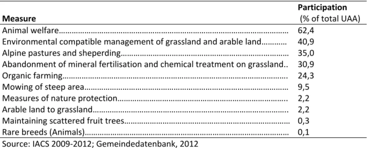
The main types of production in the CSA are arable, livestock and forestry. In terms of arable production, the main actors in landscape management are: i) small‐medium scale farmers, partly organic, (ii) local co‐operative farm holdings; (iii) Large‐scale, non‐local agro‐industrial holdings. Grazing livestock and mixed farms (dairy cows, sheep, goats, horses, game) and pig farming are the main actors in livestock production. Other actors of some relevance are nature protection associations and regional water and soil associations. The state of Brandenburg support financially the implementation of management measures associated with environmentally sound agricultural productions (KULAP, Kulturlandschaftsprogramm). In term of management practices, 18% of farm holdings are organic farms (2,691 ha; KULAP B2). Grassland management is mostly extensive, with traditional livestock and mowing with light equipment (KULAP A1, A2, A4) while set aside is feasible in low fertility locations (ca. 31 ha). Sheep grazing occur over 185 ha, cattle and horse grazing over 70 ha; late mowing interest 76 ha, and special programmes for birds are implemented over 14 ha of grasslands. Voluntary measures can be subscribed by farmers in water protection areas (lower inputs) and to keep water in the landscape through ad hoc management to encourage water logging. The maintenance of buffer zones around kettle holes (Sölle) in encouraged via voluntary measures. Other management options concern the purchase of areas for nature protection, the maintenance of orchards (KULAP A5), integrated horticulture (KULAP B1), and the use of cover crops (KULAP B4).
2.2.2 Landscape structure and elements
Land use is described according to Corine Land Cover (EEA, 2007). The shares of the different land uses are as follows: continuous urban fabric 0.07% (0.39 km2), discontinuous urban fabric 4.65% ( 26.78 km2), industrial or commercial units 0.59% (3.37 km2), airports 0.93% (5.34 km2), mineral extraction sites 0.19% (1.12 km2), artificial non‐agricultural vegetated areas 0.05% (0.29 km2), non‐ irrigated arable land 45.65% (262.73 km2), pastures 4.89% (28.16 km2), land principally occupied by agriculture with significant areas of natural vegetation 0.84% (4.85 km2), broad‐leaved forest 6.52% (37.53 km2), coniferous forest 30.28% (174.25 km2), mixed forest 3.06% (17.63 km2), natural grasslands 0.05% (0.31 km2), transitional woodland‐shrub 0.05% (0.29 km2), inland marshes 0.16% (0.90 km2), water bodies 2.00% (11.54 km2). The following table summarises the typology and the areal extension of the major landscape elements present in the agricultural areas of the CSA. The total length of the linear elements in the agricultural areas sums up to 85.8 km, including tree rows (23.2 km), hedgerows (60.7 km) and field margins (2.0 km).Table 1. Typology and areal extension of the major landscape elements in agricultural areas in the CSA (Source: Digitales Feldblockkataster (DFBK) des Landes Brandenburg).
Element Description No. Area in ha Area Share in%
BF Inland dunes 77 0.17 0.17% BR Tree rows 76 15.23 14.40% EB Single tree 49 0.12 0.11% FG Wetlands 58 5.52 5.22% FH Groups of trees 390 26.89 25.43% FR Field margins 7 0.94 0.89% FS Rock and stone areas 21 0.82 0.77% HK Hedgerows 193 43.88 41.50% NT Stone and dry stone walls (Lesesteinwall) 40 1.92 1.81% TÜ Ponds (peat lands and other comparable wetlands) 116 10.26 9.70% All groups 1027 105.74
2.2.3 Landscape functions and services
The area is characterised by a half‐open landscape and linear elements with high aesthetic value (open countryside‐woodland‐structures with important landscape conceivability) which is further supported by the pre‐existing glacial‐formed terrains and water areas; locally intense agricultural land use (e.g. maize production) counteracts the aesthetical value. The area is dived 6 different landscape units with strong heterogeneity of habitat types which provide numerous habitats for species (e.g. for game in forests). Partly the intensive arable land use and the forestry monoculture are contradicting; further habitats are partly fragmented by the infrastructure network. The main landscape functions and services are: i) provisioning (food provision, raw materials, fresh water supply); ii) regulating (climate and air quality; C sequestration and storage; moderation of extreme events; waste water treatment; erosion prevention, pollination); iii) cultural (recreation and health, aesthetic appreciation); iv) supporting (habitat for species).
2.2.4 Landscape values and benefits
Depending on the type of service and on the service used, different group of beneficiaries at different scale are identified. Local agriculture benefit from provisioning services (food provision, fresh water supply) and regulating services (extreme event moderation, erosion prevention, pollination). Local and regional societies benefit from provision services (fresh water supply), regulating services (climate and air quality, moderation of extreme events, waste water treatment), cultural services (recreation and health, aesthetic appreciation, spiritual experience and sense of place) and supporting services (habitats for species). Local and regional tourism benefit from regulating services (climate and air quality), cultural services (recreation and health, aesthetic appreciation, spiritual experience and sense of place) and supporting services (habitats for species). From the same cultural and supporting services benefit local and regional trade, industry and services. In terms of employment benefits, in Brandenburg primary (accommodation), secondary (employment and income through guest expenditures and supply) and tertiary (supply of suppliers) effects (Schulze, 1992) amount to 800 Mio. € gross value added, with 44,000 employees (2007). Tourism is economically more important than the entire primary sector (AFC, 2010), and in total 90,000 people generate income from it (Röthling, 2003). Assuming for the study area an overnight stay in the region of 40 Euro, the total turnover directly from accommodation sums up to >10 Mio € per year. The Märkische Schweiz is indeed one of the few areas in Brandenburg where tourism has the potential to contribute significantly as economic factor to complement and stabilise the rural economy (Schulze, 1992).
2.2.5 Knowledge and data gaps
Due to non‐existing monitoring data at municipality level, farm level and economic sector level, several data are currently not available. In addition IACS data (Integrated Administration and Control System) underlay high data privacy issues and are not available. In particular the following data sources are not available: Employment in local agriculture, income in local agriculture, employment in local forestry, income in local forestry, turnover and income in local/ regional tourism, employment in local/regional trade, industry, services.
Completely lacking is any information on the valuation of public and marketed goods at local or regional level, as well as on the main local second order effects.
Table 2. Main local second order effect
Beneficiary Benefit Description
Local agriculture Diversification of activity
36 farm holdings with other gainful activities (OGA)
Local/regional tourism Employment Primary (accommodation), secondary (employment and income through guest expenditures and supply) and tertiary (supply of suppliers) effects (Schulze, 1992)
In Brandenburg: 800 Mio. gross value added, 44,000 employees (2007): tourism economically more important than the entire primary sector (AFC et al., 2010); In total 90,000 people generate income from it (Röthling, 2003) Estimating a price for an overnight stay in the region of 40 Euro, the total turnover directly from accommodation sums up to >10 Mio € per year Local/regional trade, industry, services
Income Tourism marketing: little direct marketing activities for traditional handcraft (basket maker, pottery, weaving) (MLUR, 2000) Local/regional trade, industry, services Stability of rural economy Märkische Schweiz belongs to one of the few areas in Brandenburg, where tourism has the potential to contribute significantly as economic factor to complement and stabilise the rural economy (Schulze, 1992)
6 fishing companies (1998) (MLUR, 2000)
Local/regional society Employment It can be assumed that a large share of the labour force needed in agriculture, forestry, tourism, trade and service come through local/regional employment (or even self‐employment)
Local/regional society Tax Revenue Community share on business tax and income tax contribute to local municipalities’ budget. The availability of natural amenities drive real estate prices, which contribute in increased land transfer tax
Local/regional society Quality of Life Natural amenities enhance quality of life through environmental quality and better opportunities for outdoor activities
2.3 Landscape as a driver of competitiveness
2.3.1 Landscape can be considered a driver for the competitiveness
To assess the relationship between landscape and the regional welfare and competiveness it is necessary to keep a holistic picture of the CSA. Both, the core forested, nature protection intensive and the peripheral agricultural area the effect of their landscape management have effects on the same rural region, its welfare and competitiveness in terms of mutual conflicts, e.g. intensive livestock holding or renewable energy production with objective of touristic development and nature conservation. Based on the assessment carried out in the Rural Development Plan for the Federal State of Brandenburg (MIL, 2012), rural welfare and competitiveness are characterised as follow: Region: Existing local bottom‐up initiatives and degree of organisation High educational level and willingness to work among local population, but lack of employment and on‐going emigration (of young, educated population) High degree of regional identity and recognition as common area
High quality of life conditions and therefore preferred housing location, with partly good socio‐cultural infrastructure Good accessibility (within and to neighbouring regions, e.g. Berlin) Cultural landscape with a multitude of natural amenities (half‐open countryside, forests, water, relief energy) with high potential for tourism Agriculture: Competitive agricultural sector due to favourable agricultural structure and factor equipment
Less‐favoured production conditions (low soil fertility, partly wind erosion risk and disadvantages related to the comprehensive designation of protected areas)
High shares of organic and part‐time farming (which ensure also small‐scale cultivation and landscape management)
Low degree of net value added (in more work‐intensive production fields), low ownership rate and availability of capital
Missing processing and distribution
Existing quality production and certification, but underdeveloped utilisation of public relations and market niches Proximity to consumer centre, but low purchasing power in parts of the region Forestry: Large, continuing forest areas with high timber potential, but also mono‐structure, forest fire risk and high degree of small‐scale privet ownership with low degree of timber harvest.
2.3.2 The character of observed socio‐economic landscape effects
(direct/indirect/multiplier effects/ feedback loops)
The following socio‐economic effects of the use of landscape services were analysed, particularly in the context of the stakeholder consultation rounds in the LSL (Activity B) and the ad‐hoc studies (Activity C):A. Provisioning services (agricultural production): through scale enlargement going along with land accumulation and ownership change it comes to intensification of management and uniformization of cropping pattern, what leads to an increase of added value generated by land used for food or biomass provisioning services, i.e. agricultural production. However, land owners are not necessarily inhabitants and tax payers of the region.
B. Trees and point elements are contributing to regulating (e.g. local climate), habitat (e.g. birds) and cultural (e.g. traditional landscape) services. The higher their removal (die to scale enlargement), the less is the appreciation of the landscape by visitors. There is indication for negative effects on tourism general, and on preferred location of visits and spendings (restaurants etc).
C. Keeping landscape open, and maintaining diversity and abundance of single point elements, but preventing natural succession and afforestation, contributes to habitat diversity and touristic attractiveness, which again leads to added value in the region. Grazing livestock (sheep, extensive cattle) is a management form that contributes to C., particularly in case of orfganic farming.
Positive multiplier effects can be assumed in the following cases:
Provisioning services – capital market – land market prices: referring to A., in case of stock market noted companies, the positive capital return attracts new investors and generates stock growth, what leads to increased competiveness on the land market and land purchase success of the big players.
Provisioning services – habitat services – cultural services – tourism – diversification into non agricultural sector – added value in regional trade: In contrast to A. and B., in C. a high diversity of landscape elements with related provison of multiple services occurs, e.g. in case of organic farming. Increased related services enhance touristic demand and organic farmers and/or local trade take up direct marketing of further processed goods or gastronomic services at farm stead, or marketing of regional goods, what increases income in the non‐agricultural sector.
Positive feedback loops
Provisioning services – habitat services – cultural services – tourism – diversification into non agricultural sector – added value in regional trade – positive impact on health sector and tourism