HAL Id: tel-02371159
https://tel.archives-ouvertes.fr/tel-02371159
Submitted on 19 Nov 2019HAL is a multi-disciplinary open access archive for the deposit and dissemination of sci-entific research documents, whether they are pub-lished or not. The documents may come from teaching and research institutions in France or abroad, or from public or private research centers.
L’archive ouverte pluridisciplinaire HAL, est destinée au dépôt et à la diffusion de documents scientifiques de niveau recherche, publiés ou non, émanant des établissements d’enseignement et de recherche français ou étrangers, des laboratoires publics ou privés.
Spatial and temporal dynamics of fish species and
community in Tonle Sap flood pulse system
Bunyeth Chan
To cite this version:
Bunyeth Chan. Spatial and temporal dynamics of fish species and community in Tonle Sap flood pulse system. Animal biology. Université Paul Sabatier - Toulouse III, 2018. English. �NNT : 2018TOU30244�. �tel-02371159�
Title: Spatial and temporal dynamics of fish species and community in Tonle
Sap flood pulse system
Bunyeth CHAN
Supervisor: Prof. Sovan LEK
Laboratoire Evolution & Diversité Biologique, UMR 5174, Université Paul Sabatier- Toulouse III, 118 routes de Narbonne, 31062 Toulouse Cedex 4, France
Thesis submitted in fulfilment of the requirements for the degree of Doctor (PhD) in Ecology, diversity and Biology of Université Paul Sabatier- Toulouse III
This research was performed at Laboratoire Evolution & Diversité Biologique, UMR 5174, Université Paul Sabatier- Toulouse III, 118 routes de Narbonne, 31062 Toulouse Cedex 4, France.
Please refer to this work as follows:
Chan, B. 2018. Spatial and temporal dynamics of fish species and community in Tonle Sap flood pulse system. PhD thesis, University of Toulouse, France
The author and the supervisor give the authorisation to consults and to copy parts of this work for personal use only. Every other use is subject to the copyright laws. Permission to reproduce any materials contained in this works should be obtained from the author.
Résumé
Le lac Tonle Sap (TSL) est l'un des plus grands lacs du monde et est connu comme un hot-spot de la biodiversité en Asie du Sud-Est. En raison de la grande diversité ainsi que de la productivité élevée de poissons, le lac contribue à un apport important en protéines pour la population cambodgienne. Cette étude vise principalement à étudier (1) la dynamique spatiale et temporelle de la composition des communautés de poissons, (2) les effets des facteurs environnementaux sur la distribution des espèces et (3) l'effet de l'abolition des lots de pêche sur la biomasse, les communautés de poissions et le structure des poissons. En utilisant des méthodes statistiques multivariées sur les données de poissons et de variables environnementales, je suis en mesure de mettre en évidence les principales conclusions suivantes:
Les communautés de poissons du TSL étaient composées de deux assemblages de poissons: l'assemblage du nord, principalement caractérisé par des poissons noirs, et l'assemblage du sud, principalement lié aux poissons blancs, gris et estuariens. Les assemblages de poissons de la période 1994-1995 étaient représentés par l'abondance de tous les groupes fonctionnels, c'est-à-dire les poissons noirs, blancs et gris, et pour la période de 1996 à 1999, les assemblages étaient liés aux poissons blancs et gris.
Les distributions des abondances espèces de poissons n'étaient pas homogènes dans le TSL. De plus, les aires de distributions des espèces étaient différentes et étaient régies par des combinaisons distinctes de caractéristiques de l'habitat et de facteurs climatiques.
H. lobatus et H. siamensis peuvent coexister ensemble, mais la synchronisation et la migration de H. lobatus conduisent toujours à celles de H. siamensis. Ces résultats suggèrent que la population de H. lobatus est plus sensible aux variations d'impulsion de flux que celles de H. siamensis. Ceci indique que les variations des impulsions
ii d'écoulement sont les principaux déterminants responsables de la dynamique temporelle de chaque espèce.
La réforme de la politique de la pêche menée par le gouvernement entre 2000 et 2012 pour remplacer les lots de pêches commerciales par une pêche plus raisonnable a bénéficié aux espèces de petite taille avec une migration à courte distance, un niveau trophique bas, et préfèrant l'habitat de surface dans la colonne d'eau. En revanche, elle a affecté négativement les espèces de grande taille avec une migration à longue distance, un niveau trophique élevé et benthopelagique.
Les résultats de cette étude fournissent des connaissances utiles qui pourraient être utilisées pour soutenir des actions de gestion et de conservation. Par exemple, en raison du déclin temporel des grandes espèces et de la biomasse totale du lac, nous recommandons une récolte équilibrée des espèces car cela pourrait réduire les effets de pêche sur les composantes de l'écosystème. Ainsi, le renforcement du droit de la pêche doit être fortement pris en considération pour éliminer les activités de pêche illégales dans le lac Tonle Sap afin de soutenir les ressources de pêche. De plus, il faudrait envisager des mesures de conservation axées sur les zones qui soutiennent constamment des niveaux élevés de biomasse de poissons. Les résultats suggèrent également de considérer les exigences environnementales de chaque espèce pour gérer efficacement les ressources halieutiques. En outre, la période de présence de certaines espèces clés devrait être prise en compte dans le cadre d'une règlementation ou d'une politique pour mieux gérer et conserver les espèces. La saisonnalité et la prévisibilité des inondations du Mékong devraient être maintenues pour soutenir la dynamique naturelle des espèces de poissons.
Mots-clés: pêche à grande échelle, réforme de la politique de pêche, composition des
communautés de poissons, structure des communautés, impulsion d'inondation, distribution spatiale, préférence d’habitat, synchronisation des poissons
iii
Abstract
Tonle Sap Lake (TSL) is one of the world’s largest lakes and is a biodiversity hotspot in Southeast Asia. It supports high fish productivity which sustains protein supply for millions of people in the region. This study aims to investigate (1) spatial and temporal dynamics of fish community composition, (2) the effects of environmental factors on fish distribution and (3) effects of fishing lot abolishment on fish biomass, community and structure in TSL. By using multivariate statistical methods on fish and environmental data, the thesis highlights that:
There were two fish assemblages in TSL: the northern assemblage, mostly characterised by black fishes, and the southern assemblage, mainly linked to white, grey and estuarine fishes. Fish assemblages from earlier years (1994 and 1995) were represented by the abundances of all functional groups, i.e. black, white and grey fishes, and from 1996 to 1999, the assemblages were linked only to white and grey fishes.
Fish species distributions were not homogeneous within TSL. In addition, species distribution areas were different and were governed by distinct combinations of the local habitat characteristics and regional climatic factors.
H. lobatus and H. siamensis can co-occur together, but synchronisation and migration of H. lobatus always lead those of H. siamensis. These results suggest that the population of H. lobatus is more responsive to flow pulse variations than those of H.
siamensis.
The fisheries policy reform introduced by the government in 2000 and 2012 to remove all the commercial fishing lots in favour of subsistence fisheries positively benefited small-sized species with short distance migration, low trophic level, and prefer the surface habitat in the water column. In contrast, it negatively affected the large-sized species with long-distance migration, high trophic level and preferred deeper water column.
iv The results of this study provide useful knowledge, which could be used to support management and conservation actions. For instance, due to the temporal decline of the large species and the total fish biomass of the lake, we recommend focusing on the balanced harvesting because it could reduce the effects of the fishing on the fish community. Thus, the fisheries law reinforcement must be highly taken into consideration to eliminate the widespread illegal fishing activities in the TSL to sustain fisheries sources for long-term use. Moreover, conservation actions should be focused on the areas that consistently support high fish biomass levels. The results also suggest considering the environmental requirements of each species to efficiently manage fish resources. Also, the timing of the occurrence of some keystone species should be taken into account as a part of a regulation or policy consideration to better manage and conserve the species. Seasonality and predictability of the Mekong floods should be maintained to sustain the natural dynamics of fish species.
Keywords: large-scale fisheries, fisheries policy reforms, fish community composition,
community structure, flood pulse, spatial distribution, habitat preference, fish synchronisation
v
Contents
Résumé ... i
Abstract ... iii
Chapter I: General Introduction ... 1
1.1 Inland fisheries ... 1
1.2 A general overview of the Mekong River ... 2
1.2.1 The Mekong River ... 2
1.2.2 The Mekong fisheries ... 4
1.3 A brief of Tonle Sap Lake ... 4
1.3.1 Tonle Sap Lake ... 4
1.3.2 Tonle Sap flood pulse system ... 5
1.3.2 Tonle Sap Lake fisheries ... 6
1.4 Migration of fish in the Mekong River ... 6
1.5 Descriptions and ecology of the main commercial fish species in Tonle Sap Lake ... 7
1.6 Research problems, aims and objectives ... 14
1.7 Hypotheses ... 17
References ... 19
Chapter II: Materials and Methods ... 26
2.1 Study area ... 26 2.2 Data collection ... 26 2.3 Statistical analyses ... 30 2.3.1 Community clustering ... 30 2.3.2 Comparative analysis ... 30 2.3.3 Predictive models ... 30 2.3.4 Multivariate analyses ... 31 2.3.5 Time-series analyses ... 32 References ... 34
Chapter III: Spatial and temporal changes in fish yields and fish communities in the largest tropical floodplain lake in Asia ... 36
3.1 Introduction ... 38
3.2 Materials and methods ... 40
3.2.1 Study area ... 40
3.2.2 Data collection ... 40
3.2.3 Statistical analyses ... 42
vi 3.3.1 Temporal trends of main commercial fishes, TSL’s species richness, and fish
yields ... 42
3.3.2 The fish yields-flood pulse relationship ... 44
3.3.3 Spatio-temporal variability in the fish community and its yields ... 45
3.4 Discussion ... 51
3.4.1 Temporal trends in fish yields of the main commercial fishes and total fish yields of the lake ... 51
3.4.2 Relationship between fish yields and flood pulse ... 53
3.4.3 Spatial and temporal change in fish communities and its yields ... 53
3.5 Conclusion ... 55
References ... 57
Chapter IV: Influence of local habitat and regional climatic factors on the distribution of fish species in Tonle Sap Lake ... 62
4.1 Introduction ... 64
4.2 Materials and methods ... 65
4.2.1 Data collection ... 65
4.2.2 Data preparation ... 69
4.2.3 Statistical analyses ... 70
4.3 Results ... 71
4.3.1 Spatial distribution ... 71
4.3.2 Relationships between the local habitat and regional climatic factors with fish distribution ... 74
4.4 Discussion ... 78
References ... 84
Chapter V: Modelling dynamics of two small mud carp species in the Tonle Sap flood-pulse ecosystem using spatial and time-series data ... 92
5.1. Introduction ... 94
5.2. Materials and methods ... 96
5.2.1. Site descriptions ... 96
5.2.2. Data collection and processing ... 97
5.2.3. Modelling techniques and analyses ... 99
5.2.3.1. Modelling techniques ... 99
5.2.3.2. Data analyses ... 100
5.3. Results ... 102
vii
5.3.2. Synchronisation, peak abundance, and movement patterns ... 104
5.3.3. The time-lagged relationship with water levels ... 105
5.4. Discussion ... 109
5.4.1. Performance and applications of time-series analyses ... 109
5.4.2. The role of flow pulse in the spatial and temporal dynamics of fishes ... 109
5.4.3. Monitoring and management perspectives ... 111
5.5. Conclusions ... 113
References ... 115
Chapter VI: Effectiveness of fisheries policy reforms to maintain fish diversity and abundance in Tonle Sap Lake ... 124
6.1 Introduction ... 127
6.2 Material and methods ... 129
6.2.1 Sites description ... 129
6.2.2 Data collection ... 130
6.2.3 Data preparation and statistical analyses ... 131
6.3 Results ... 133
6.4 Discussion ... 140
References ... 147
Chapter VII: Summary, conclusion and perspectives ... 154
7.1 Summary ... 154
7.2 Main conclusion and remarks ... 159
7.3 Perspectives ... 167
viii
ACKNOWLEDGEMENTS
First of all, I would like to express my sincere gratitude to my thesis supervisor Prof. Sovan LEK, Université Paul Sabatier-Toulouse III, France, for his guidance, constructive suggestions, scientific orientation, statistical analyses, support, encouragement, and patience during the period of my PhD. Thanks you so much for your quick response and always available for discussion. His advice, guidance, and encouragement lead me to reach the success. I thank you very much for providing me with the possibility to get this PhD project.
I would like to thank Prof. Sébastien BROSSE, Université Paul Sabatier-Toulouse III, France, for providing suggestions, constructive idea and remarks on the manuscripts. My special thanks are also expressed Dr. Peng Bun NGOR, Fisheries Administion, Cambodia, for data arrangement, idea on fish ecology, and remarks on the manuscript, Dr. Ratha SOR, Research Post-doctoral at Ghent University, Belguim, for motivating me to pursue PhD and providing me comments and Dr. Nam SO, Chief of Environment Division of the Mekong River Commission for his cooperation and supportion of data used in this study.
I am also greatful to my referees and jury members (Prof. Lluís BENEJAM, Dr. Hervé CAPRA, Prof. Sébasien BROSSE, Prof. Michelle TACKX and Dr. Ratha CHEA) for accepting to review, evaluate and read my thesis as well as providing useful comments on my work and for continuing to inspire me to go on with the research path.
I also would like to express profound thanks to the staffs from the Faculty of Science, Royal University of Phnom Penh: Prof. Kamerane MEAK, Dr. Nicholas J. SOUTER, Mr. Des PHAL, Dr. Saveng ITH, Ms. Seanghun MEAS, Mr. Sophany PHAUK, and Mr. Sokha KHEAM for their encouragement and motivate me to pursue PhD.
Deep thanks to Asso. Prof. Gaël GRENOUILLET for his technical advice, Dr. Loic TUDESQUE for his assistance in GIS and Map production, and Dr. Kévin CILLEROS for this assistance with statistical analysis and R-script.
ix My scientific support is extended to AQUAECO team: Dr. Ratha SENG, Dr. Ratha CHEA, Dr. Kong HENG, Dr. Kévin CILLEROS, Dr. Lucie KUCZYNSKI, Dr. Jade BRUXAUX, Ms Marine CAMBON, Mr Gouhan SU, Dr. Mingli LIN, and Mrs Jiyu LIN for their support and assistance.
I am grateful to the Erasmus Mundus Programme (Lotus+ Project) and the Belmont Forum (TLSCC Project) for providing financial support. Also, I wish to thank the Mekong River Commission (MRC) for providing the dataset used in this study. Moreover, my sincere thanks are also given to Dominique PANTALANCI, Mrs. Nicole HOMMET, Mrs. Linda JALABERT, Ms. Emma BRIFFAUT, and Ms. Philippine GUILLAUME for their administrative assistance.
I would like to express a special appreciation to Prof. Dr. Sovan LEK and Asso. Prof Sithan LEK for their warm hospitality, delicious food, and driving me to many places.
Many thanks to Cambodian brothers and sisters in Toulouse: Mr. Sopheak SAM, Mrs. Sinoun UN, Mrs. Sopheap KHUON, Mr. Piseth YANG and Mr. Loy CHHUON for their hospitalities, kindness, and delicious food. Thank Cambodian friends in Toulouse: Mr. Rotana LY, Mr. Sotheara MOEUNG, and Mrs. Solina VAN for their assistance in administration.
My deep thanks are also given to my beloved parents and sisters for their support and motivation.
1
Chapter I: General Introduction
1.1 Inland fisheries
The fish resource provides one of the primary sources of animal protein consumed worldwide and income, especially for people in developing countries (Allan et al., 2005). In developing countries, fish protein sources are mainly derived from the harvest of natural fish stocks, while those in developed countries are produced by recreational fisheries or aquaculture (Allan et al., 2005; Welcomme et al., 2010). Among the natural fish stock, poor people in developing countries are more dependent on inland fisheries resources than marine sources (McIntyre, Reidy Liermann, & Revenga, 2016). The main of the global inland fisheries sources are derived from developing countries (Bartley, Graaf, Valbo-Jorgensen, & Marmulla, 2015; De Graaf, Bartley, Jorgensen, & Marmulla, 2015). Worldwide, inland capture fisheries are from the lakes and wetland that cover an approximately total area of 7.8 million km2 (De Graaf et al., 2015; Welcomme et al., 2010). Inland capture fisheries refer to the catch or harvest of natural stock of freshwater fish and other living organisms from freshwater bodies (Allan et al., 2005; Welcomme et al., 2010). Geographically, the area covered with surface waters are relatively from Southeast Asia, North America, East and Central West Africa, the northern part of Asia, Europe and South America. Inland capture fisheries represent only 6.3% of the global fish production and 95% of which are from developing countries, i.e. Asia and Africa (Bartley et al., 2015; De Graaf et al., 2015; Welcomme et al., 2010). Inland fisheries are not only important for protein sources and global food supply, but they also are of paramount importance for livelihoods of people in many parts of the developed and developing countries, and it provides employment to 61 million people (Allan et al., 2005; Bartley et al., 2015; Welcomme et al., 2010). In addition, approximately 1 billion people in the world, mostly in developing countries, depending on the protein sources derived from fish (Allan et al., 2005). Indeed, harvesting the natural fish stock has rapidly
2 increased in developing countries, but decreased in developed countries while many commercial inland fisheries were replaced by recreational fisheries (Allan et al., 2005; Cooke & Cowx, 2004). Overall, from the report data, the global catch of inland fisheries is increased because of an increase in the exploitation in Asia and Africa and an increase in human population density (FAO, 2014; McIntyre et al., 2016). Meanwhile, the global inland capture fisheries trend has been stable from 2000 to 2004 containing approximately 8.6 million tonnes, however its products reached 10 million tonnes in 2008 and increased up to 11.63 million tonnes in 2012, that the highest contribution is from developing countries (Bartley et al., 2015; De Graaf et al., 2015; Welcomme, 2011). Nonetheless, these statistical data is not accurate (Allan et al., 2005; Bartley et al., 2015; De Graaf et al., 2015; Welcomme, 2011; Welcomme et al., 2010). However, with the correct estimation, the global catch of fisheries has been declining (Pauly et al., 2002; Watson, Watson, & Pauly, 2014). Evidence revealed the collapse or decline in inland fisheries resources due to intensive fishing and multiple uses (Allan et al., 2005; Bartley et al., 2015; Welcomme et al., 2010). Consequently, the excessive fishing of inland fisheries adversely influences human health, especially people in developing countries (Allan et al., 2005).
1.2 A general overview of the Mekong River 1.2.1 The Mekong River
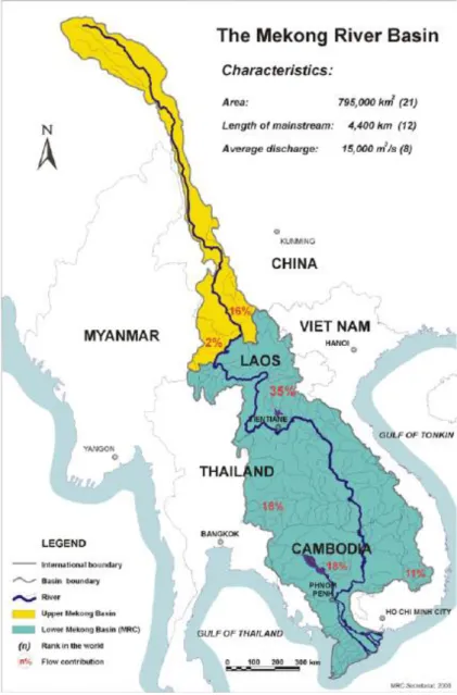
The Mekong River is the largest river in South-East Asia. From its sources in the Tibetan Himalaya China, it flows through six countries, i.e. China, Myanmar, Lao PDR, Thailand, Cambodia and Viet Nam, and conversa distance of more than 4880 km (Figure 1.1; MRC 2005). The Mekong River covers a total drainage area of 795,000 km2 (MRC, 2005). In term of mean water discharge, the Mekong River is ranked the eight world largest river, and it discharges approximately 475,000 million cubic meters of water into the South China Sea (Gupta, Hock, Xiaojing, & Ping, 2002; Matti Kummu & Sarkkula, 2008; Anders F Poulsen & Valbo-jørgensen, 2000). The Mekong River is classified into two parts: the Upper Mekong
3 River and the Lower Mekong Basin (MRC, 2005). The Lower Mekong Basin (LMB) includes portions of Thailand, Laos, Cambodia and Vietnam. The Mekong River is a typical floodplain river, dominated by the monsoon climate of Southeast Asia (A. Poulsen, Poeu, Viravong, Suntornratana, & Tung, 2002). It is a dynamic river system, alternating between a flood season from May to October and a dry season from November to April. The monsoon flood-pulse create the vast areas of seasonally inundated floodplains adjacent to the river channels every year. The hydrological cycle served as a determinant for seasonal migration of fish. Floodplains are extremely productive feeding habitats for most important fishes, whereas the river channels mainly serve as refuge habitats during the dry season (A. Poulsen et al., 2002).
4
1.2.2 The Mekong fisheries
The Mekong River lies within the Indo-Burma biodiversity hotspot (Allen, Smith, & Darwall, 2012; Myers, Mittermeier, Mittermeier, Da Fonseca, & Kent, 2000) and is the second most diverse river system in the world, which host over 1200 fish species, after the Amazon River (Allan et al., 2005; Eric Baran, 2005; Brosse et al., 2013). However, only 50-100 species are common in the Mekong fishery. Moreover, many of which are still waiting for taxonomic identification and confirmation, thus the number of species is assumed to be higher than this. Apart from its important role as high diversity, the Mekong River is also one of the most intensive and productive inland fisheries in the world due to an extensive floodplain system nurtured by annual monsoons (Eric Baran, 2005; Eric Baran & Gallego, 2015) with annual yields of approximately 2.6 million tons, that have the largest contribution to the global inland capture fisheries (Hortle, 2007; Welcomme et al., 2010). It also has provided food sources and animal protein for 60 million people living in the region, that most of whom directly and indirectly rely on the fisheries resources of the Mekong River for their income and food security (MRC, 2010). In this regard, the average consumption of fish and other aquatic animals is estimated at 56 kilograms (kg) per capita per year in the lower Mekong Basin (Hortle, 2007). The system is highly productive due to an extensive floodplain system nurtured by annual monsoons (Eric Baran & Gallego, 2015).
1.3 A brief of Tonle Sap Lake 1.3.1 Tonle Sap Lake
Tonle Sap Lake is situated in the central of Cambodian consisting of the largest wetland area in Southeast Asia and covers about 5 to 8 per cent of the total land area (Matti Kummu & Sarkkula, 2008; MRC, 2003, 2005). Tonle Sap Lake and the Mekong River are connected to each other by Tonle Sap River (TSR) with 120 km long (M. Kummu et al., 2014). Tonle Sap Lake was characterized by a tropical monsoon climate (Arias, Cochrane, Norton, Killeen, & Khon, 2013). Hydrological flows of Tonle Sap Lake are influenced by flood waters
5 of the Mekong River, and this creates a complex flood-pulse ecosystem (Arias et al., 2013; M. Kummu et al., 2014; MRC, 2005). The surface area of Tonle Sap Lake seasonally fluctuates from 2500 km2 to 15000 km2 driven by seasonal flood pulse from the Mekong River (M. Kummu et al., 2014).
1.3.2 Tonle Sap flood pulse system
Tonle Sap Lake is defined as a flood-pulse system due to its seasonal periodicity in hydrological flows. In the wet season (May-October), the water flows into Tonle Sap Lake through TSR due to increased water levels in the Mekong River, whereas in the dry season (November-April), a reverse flow occurs through TSR again due to the receding water levels in the Mekong River (MRC, 2005). The water levels highly vary between seasons; the water depth ranges from 0.5 metres in April (dry season) to 9 metres in September-October (rainy season). This variation leads to a varied surface area of Tonle Sap Lake throughout the year and thus creates more heterogeneous habitats compared to TSR (MRC, 2005). The flood pulse creates a substantial floodplain that is habitat for a variety of aquatic and terrestrial plant and animal species (Ian C. Campbell, Poole, Giesen, & Valbo-Jorgensen, 2006). A large number of floodplain areas were inundated and formed large breeding and spawning areas for the fishes (Eric Baran, Jantunen, & Kieok, 2007). Tonle Sap Lake also forms a natural reservoir that stores the floodwater for the Mekong system (Sarkkula et al., 2004). Tonle Sap Lake was characterized by a tropical monsoon climate (Arias et al., 2013). In these ecosystems, the pulsing is one of the major forces responsible for productivity and biotic interactions (Junk, Bayley, & Sparks, 1989). Here, the pulsing allow moving the littoral which enables the rapid recycling of organic matter and nutrient and then bring about the high productivities (Junk et al., 1989).
6
1.3.2 Tonle Sap Lake fisheries
Tonle Sap Lake is the largest natural inland lake in Southeast Asia (MRC, 2005) and hosts a diverse fish fauna, with 296 fish species (Eric Baran, So, Degen, Chen, & Starr, 2013). Tonle Sap Lake is therefore considered a biodiversity hotspot (Allen et al., 2012) and has had the status of a UNESCO world heritage biosphere reserve since 1997 (UNESCO, 2018). This lake is the world’s fourth most productive inland fishery (Eric Baran, 2005) with annual estimated yields of 246,000 tons (Lieng & Zalinge, 2001).
Tonle Sap Lake plays a crucial role in providing fish products and protein to nearly two million people in the region (Ahmed, Hap, Ly, & Tiongco, 1998), and Tonle Sap Lake fisheries account for 60% of the total protein intake of the approximately 15 million Cambodian people (Ahmed et al., 1998; Lieng & Zalinge, 2001). The average consumption of fish and other aquatic animals is estimated at 71 kg per capita per year around Tonle Sap Lake in Cambodia (Ahmed et al., 1998). Income from inland capture fisheries and other aquaculture contribute about 10% of Cambodia Gross Domestic Product (GDP) (E Baran, Schwartz, & Kura, 2009).
1.4 Migration of fish in the Mekong River
Migration is the movement of an animal during one part of its life cycle (A.F. Poulsen, Ouch, Viravong, Suntornratana, & Nguyen, 2002). Migration of fish is an important ecological aspect of many tropical rivers. Different migration behaviours result from adaptions to hydrological and environmental conditions (Anders F Poulsen & Valbo-jørgensen, 2000). Migration of the Mekong fish are divided into three longitudinal migration (long distance migration), lateral migration (short distance migration) and non-migration (or floodplain resident) (A.F. Poulsen et al., 2002). The longitudinal migration refers to movement of the fish in the main river channels and their main tributaries, while the lateral migration refers to the migration of fish from the main river and tributaries to floodplain area during the flood season and back again during the dry season (Anders F Poulsen & Valbo-jørgensen, 2000). The
7 migration of fish in the Mekong River serve the paramount importance for fisheries as the huge amount of fisheries resources are based on the exploitation of the migratory fishes (Anders F Poulsen & Valbo-jørgensen, 2000).
Cambodian river fish species are classified into three functional groups: blackfish, white and grey fish according to their habitat characteristics (A.F. Poulsen et al., 2002). Blackfish in the Mekong River includes climbing perch (Anabas testudineus), the clarias catfishes (e.g. Clarias batrachus) and the striped snakehead (Channa striata) (A.F. Poulsen et al., 2002). Black-fishes mostly live in lakes and swamps on the floodplains near river channels and migrate to flooded areas during the flooded season (A.F. Poulsen et al., 2002). They are adapted to a low oxygen environment, which enables them to stay in swamps and small floodplain lakes during the dry season. Blackfish are considered non-migratory species even though they migrate between permanent and seasonal water bodies (A.F. Poulsen et al., 2002). White-fishes mostly inhabit the turbid water river channels for some part of the year (A.F. Poulsen et al., 2002). Most white-fish species migrate into flooded areas during the monsoon seasons, and back to their river habitats at the end of the flood season (A.F. Poulsen et al., 2002). The Mekong white fish are cyprinids (e.g. Cyclocheilichthys enoplos and Cirrhinus
microlepis), the river catfishes of the family Pangasiidae (A.F. Poulsen et al., 2002). During
the dry season, larger white fish survive in deep pools of the main floodplain areas while blackfish spend their lives feeding and breeding in the floodplain water bodies (Deap, Degen, & Zalinge, 2003).
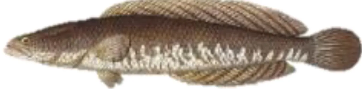
1.5 Descriptions and ecology of the main commercial fish species in Tonle Sap Lake Striped snakehead Channa striata (Bloch, 1793)
The striped snakehead Channa striata were distributed in tropical Africa and southern Asia, i.e., Pakistan to Thailand and South China (Figure 1.2; Froese & Pauly, 2017). In Cambodia,
Channa striata are the common fish species that were found in many places throughout the
8 1998). In addition, they have been commonly introduced in rice field farming, and they are very important in Cambodian aquaculture (Chheng, Touch, Baran, & Leng, 2005). Biologically, the striped snakehead prefers the flood-plain lakes and smaller streams than in the Mekong mainstream (S. Chan et al., 2000). Moreover, they were mainly recorded in the still water and stagnant and muddy fresh water of plains habitats of the ponds, swamp, streams and lowland rivers with 1-2 metre in depth (Chheng et al., 2005). As the blackfish, the striped snakehead could adapt to the low oxygen environment during the season by burrowing themselves in the bottom mud of lakes, canals and swamps (Chheng et al., 2005). During the rainy season, they migrate upstream from the Mekong mainstream toward the flooded areas and move back to the permanent water bodies at the receding water, especially the early of the dry season (S. Chan et al., 2000). Ditches, ponds and flooded paddy fields have been known the important breeding ground of the striped snakehead. Meanwhile, in Cambodia, the breeding periods of this species were reported in May-June and November-December (Chheng et al., 2005). The striped snakehead has been known the parent care species in which the parents protect their babies by hiding below the surface water while the babies swim at the surface (Froese & Pauly, 2017). The main food contents for this species are bony fish, frogs, insects, earthworms, tadpoles and crustaceans (Rahman, 1989).
Figure 1.2 Photos of the striped snakehead Channa striata (Bloch, 1793). The photo were
derived from Rainboth (1996). The maximum length of this species was 100 cm in standard length.
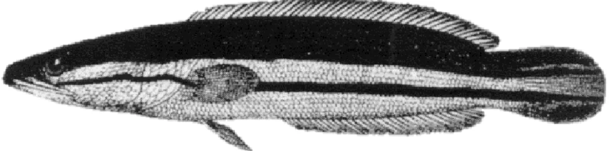
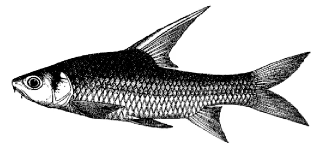
9 Similar to the striped snakehead Channa striata, the distribution of the giant snakehead
Channa micropeltes was found in both tropical Africa (Figure 1.3; Froese & Pauly, 2017).
Like the strip snakehead, the giant snakehead Channa micropeltes is important for aquaculture, and they are also commonly introduced in the rice field farming (Chheng et al., 2005). The important habitats for Channa micropeltes were the standing or slowly flowing water of the deep and large streams and canals (Maurice Kottelat, 1998; Rainboth, 1996). They were also found in the swamp and the lowland river. In addition, small streams with dense vegetation habitats were important spawning ground for Channa micropeltes. They are Carnivorous top predator that forage primarily on fish and crustaceans (Froese & Pauly, 2017).
Figure 1.3 Photos of the giant snakehead Channa micropeltes (Cuvier, 1831). This photo
was retrieved from Rainboth (1996). The maximum length of this species was 130cm in standard length.
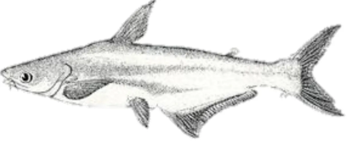
Sutchi catfish Pangasianodon hypophthalmus (Sauvage, 1878)
The sutchi catfish Pangasianodon hypophthalmus were recorded from the Mekong Basin, including Tonle Sap Lake and Tonle Sap River (Figure 1.4; Maurice Kottelat, 1985; Lim, Lek, Touch, Mao, & Chhouk, 1999). They have been the longitudinal migratory fish that undertake the long-distance migration from rearing areas to spawn in unknown areas during May-July and move back to the mainstream to search for the rearing habitats when the river water level recedes between September-December (Hill & Hill, 1994). During the rainy season, from May to August, they move downstream from the Mekong Stung Treng to Kandal in Cambodia and
10 continue migrating toward the Mekong Delta in Viet Nam (S. Chan et al., 2000). The purposes of this downstream migration were to spawn and feed and then migrate to the floodplain areas during the flooded season (S. Chan et al., 2000). The receding of the water, on the early of the dry season, appeared to be the main determinant that triggers this species to undertake the later migration from the flooded areas back into the Mekong at the end of the flood season (S. Chan et al., 2000). The young babies were commonly found in the lower Mekong while the large individuals were mainly observed in the in the Middle Mekong (Rainboth, 1996). They were reported to live in the deep and large rivers They have been the Omnivorous fish that feed on a variety of food types such as fish, crustaceans and vegetable debris (Rainboth, 1996).
Figure 1.4 Photos of the sutchi catfish Pangasianodon hypophthalmus (Sauvage, 1878). The
photo was derived from Rainboth (1996). The maximum length of this species
Cyclocheilichthys enoplos (Bleeker, 1850)
Cyclocheilichthys enoplos has been known a longitudinal migratory species in the Mekong
River that their distribution was found in the Mekong Basin, Stung Treng, the Tonle Sap River and the Tonle Sap Lake (Figure 1.5; Maurice Kottelat, 1985). The number of
Cyclocheilichthys enoplos population start to be less and less below the Khone Fall to the
Tonle Sap River and Tonle Sap Lake (Hill & Hill, 1994). During the flooded season, it was reported that Cyclocheilichthys enoplos migrate from the Mekong River toward the Tonle Sap
11 River and the Tonle Sap Lake (S. Chan et al., 2000). During the dry season, specifically when the water level recedes, the juveniles and adults move out of the lake flooded areas toward the river and migrate back toward the upstream in the Mekong. They were found at midwater to bottom levels of the mainstream and large tributaries of the Mekong River (Rainboth, 1996). The floodplain area or flooded riparian forests serve the important spawning grounds of
Cyclocheilichthys enoplos (Froese & Pauly, 2017). The main food composition for young was
zooplankton whereas the insect larvae, crustaceans and fish were the main foods for adults (Rainboth, 1996).
Figure 1.5 Photos of Cyclocheilichthys enoplos (Bleeker, 1850). The photo was derived
from Rainboth (1996). The maximum length of this species was 74cm in standard length.
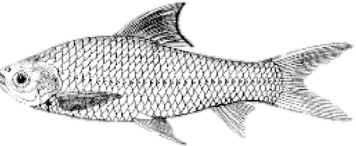
Trey Riel small mud carp Henicorhynchus spp
Trey Riel Henicorhynchus spp contains two main important species: Henicorhynchus lobatus and H. siamensis. Both species form the keystone species within the Mekong River (Figure 1.6; Froese & Pauly, 2017). The distribution of Trey Riel small mud carp was found in the Mekong River, Tonle Sap River and Tonle Sap Lake (M. Kottelat, 2001; Maurice Kottelat, 1985; Lim et al., 1999). They were found in the rapids and slow flowing water habitat in the mid-water to bottoms depths in large and small rivers (Froese & Pauly, 2017; Singhanouvong,
12 Soulignavong, Vonghachak, Saadsy, & Warren, 1996). They undertook the longitudinal migration that moves into the floodplain area during the wet season for feeding and moves back to the rivers at receding water at the early October to December (Rainboth, 1996). The main food composition of Trey Riel small mud carp were plants, algae, periphyton and phytoplankton (Froese & Pauly, 2017).
Figure 1.6 Photos of Trey Riel Siamese mud carp Henicorhynchus siamensis (Sauvage, 1881).
This photo was extracted from Rainboth (1996). The maximum length of this species was 20 cm in standard length.
Java barb Barbonymus gonionotus (Bleeker, 1850)
Java barb Barbonymus gonionotus has been considered a migratory species that undertake the lateral migration moving from the Mekong River toward the small streams and tributaries and flooded area during the rainy reason and move back to the Mekong River during the dry season (Figure 1.7; S. Chan et al., 2000). They were found in at mid-water to bottom depths in rivers, streams, floodplains, and occasionally in reservoirs. Moreover, they live in the flooded forest during the flooded season (Rainboth, 1996). The first rain and rising water level were the important factors that trigger Barbonymus gonionotus to move from the Mekong River toward a tributary, canal or stream and then migrate to the flooded areas (S. Chan et al., 2000). The main food compositions for this species were planted matter leaves, weeds and invertebrates (Froese & Pauly, 2017).
13
Figure 1.7 Photos of the Java barb Barbonymus gonionotus. The photo was derived from
(Rainboth, 1996). The maximum length of this species
Moonlight gourami Trichopodus microlepis (Günther, 1861)
The moonlight gourami Trichopodus microlepis has been known as a common species in the floodplain of the lower Mekong (Figure 1.8; Froese & Pauly, 2017). They were found in the Mekong River in Cambodia and Viet Nam and Chao Phraya basins (M. Kottelat, 2001). They were mainly found in ponds and swamps, especially in the shallow sluggish or standing water habitats with a lot of aquatic vegetation (Froese & Pauly, 2017). Zooplankton, crustaceans and aquatic insects were the main food contents for the moonlight gourami (Chheng et al., 2005).
14
Figure 1.8 Photos of the moonlight gourami Trichopodus microlepis (Günther, 1861). The
photo was derived Rainboth (1996). The maximum length of this species
1.6 Research problems, aims and objectives
Tonle Sap Lake (TSL) is the largest natural lake in Southeast Asia, and it is a diverse and productive lake (MRC, 2005). However, the knowledge of the fisheries and fish ecology in Tonle Sap Lake is poorly known. Given the fact that the fisheries of Tonle Sap Lake is being threatened by various factors such as intensive fishing through population growth, insufficient effectiveness of fisheries resources, and habitat disturbance (Allan et al., 2005), thus, there is a need to investigate the spatio-temporal dynamics of fish community, the effects of the removal of the commercial fishing lots of, the effects of environmental descriptors on distribution of fish species, and the role of the flood pulse on the spatio-temporal dynamics of fish species in Tonle Sap Lake.
On the other hand, regarding fish ecology, the distribution, and migration of fish species, many studies have been conducted in Tonle Sap Lake, e.g., fish species diversity and distribution (I.C. Campbell, Poole, Giesen, & Valbo-Jorgensen, 2006; Ian C. Campbell et al., 2006; B. Chan, Ngor, So, & Lek, 2017; Lim et al., 1999), fish beta diversity (Kong, Chevalier, Laffaille, & Lek, 2017), and the water quality-fish composition relationship (Chea, Grenouillet, & Lek, 2016), data mining and stock assessment of fisheries resources (Enomoto et al., 2011). However, knowledge of the parameters affecting the spatial distribution, spatio-temporal dynamics and migration of fish species in Tonle Sap Lake are poorly known. Therefore, determining the environmental factors on the distribution and migration of fish species is needed.
Besides the species distribution and ecological study, many studies have been highlighted and discussed about the effectiveness of the Cambodian fisheries policy reforms in Tonle Sap Lake in terms of property right, governance, management policy and legislation,
15 and reviewed and expected the fisheries status based on the biological and ecological features of fish species, i.e. (Cooperman et al., 2012; Dina & Sato, 2014, 2015; Ratner, 2006; Ratner, Mam, & Halpern, 2014; Sok, 2014). However, providing the statistical evidence about the characteristics of fisheries and fish species impacted by this fisheries policy reforms is in the gap. Thus, providing evidence about the effects of the removal of the commercial fishing lots on fisheries and community and structure based on statistics data would be more informative.
The aims and specific objectives (or question) of the present study are:
1. Investigating the spatio-temporal changes in fish yields and fish communities in Tonle Sap Lake
1.1. Illustrating the temporal trend of the main commercial fish and fish yields of Tonle Sap Lake.
1.2. Investigating the relationship between the flood pulse and fish yields of Tonle Sap Lake
1.3. Identifying the spatial and temporal patterns of fish community within Tonle Sap Lake. 2. Investigating the importance of the local habitat and regional climatic factors on the
distribution of fish species in Tonle Sap Lake.
2.1. Illustrating the spatial distribution of the main commercial fish species in Tonle Sap Lake.
2.2. Determining the influence of the environmental factors on the spatial distribution of the main commercial fish species in Tonle Sap Lake.
3. Modelling the dynamics of fish species in the flood pulse system at spatial and time 3.1. Is there any synchrony in occurrence between the two species, and is there a constant
periodic occurrence of each species (e.g., re-occurring monthly or seasonally or annually)?
16 3.2. How is the period of synchronisation and movement patterns of each species varied
across the Tonle Sap Ecosystem?
3.3. Is there any time-lagged relationship between the synchronisation of each species and water levels?
4. Assessing the effectiveness of the removal of the commercial fishing lots on fisheries, fish community composition and structure.
4.1. Investigating the overall trends in fisheries in the two periods: before and after fishing lot abolishment.
4.2. Analysing the variability or dynamics of fish community composition between two periods.
4.3. Identifying the species that changed and linking the status of fish species (increasing, decreasing and non-change) with morphological and biological traits.
17
1.7 Hypotheses
The fisheries reforms allow removing all commercial fishing lots in favour of subsistence fisheries. Given that fishes could freely migrate and conduct substantial spatial distribution, we hypothesised that this fisheries policy reforms positively affect the long-distance migration of fish species. If the law enforcement is sufficient, it was expected that the removal of the commercial fishing lots that the fisheries policy reforms or the fishing lot abolishment might contribute to maintain fishery productivity and protect the biological diversity, and improve the sustainability of Tonle Sap Lake fisheries. In addition, the small fish species and floodplain residence fish species were expected to have benefitted from conservation area after the fisheries policy reforms (Cooperman et al., 2012). In contrast, while the area of the lake is open and free to access by all people, if the law enforcement is insufficient, the illegal fishing practices happen that lead the overfishing. Thus, the fisheries reforms would have negative effects on fisheries resources of TSL.
Moreover, it was hypothesised that the distribution of fish species within Tonle Sap Lake are heterogeneous. Fish species have a different response to the habitat characteristics and climatic feature. All species do not have the same perception of the heterogeneity of their habitat (Kolosa, 1989). Thus, we hypothesised that the responses of fish species to their environmental determinants are species-specific. The distribution of each species was not determined by the same environmental factors (Buisson, Blanc, & Grenouillet, 2008). Additionally, the distribution of fish species is regulated by the combined environmental descriptors. It was hypothesised that both local habitat and regional climate have the potential effects on the spatial distribution of fish species. This observation leads us to discuss the ecological significance of such a fish species distribution. This work could contribute to the modelling assessment of the factors and processes controlling freshwater ecology within Tonle Sap System.
18 Furthermore, while Henicorhynchus lobatus and H. siamensis have dissimilarities in ecological preferences and life history traits (Hurwood, Adamson, & Mather, 2006), we expected distinct periods of the occurrence, synchronisation and time-lagged relationship to be observed for each species in different parts of the Tonle Sap Ecosystem, following the variations in water levels. It was hypothesised that the flood pulse leads the synchronisation and movement pattern of the small mud carp species. Thus, the variation of flood pulse plays an important role in regulating the spatial and temporal dynamics of two small mud carp species in a large flood pulse system.
19
References
Ahmed, M., Hap, N., Ly, V., & Tiongco, M. (1998). Socioeconomic assessment of
freshwater capture fisheries in Cambodia: report on a household survey. Phnom Penh, Cambodia: Mekong River Commission.
Allan, J. D., Abell, R., Hogan, Z., Revenga, C., Taylor, B. W., Welcomme, R. L., & Winemiller, K. (2005). Overfishing of inland waters. BioScience, 55(12), 1041–1051. Allen, D. J., Smith, K. G., & Darwall, W. R. T. (2012). The status and distribution of
freshwater biodiversity in Indo-Burma. Cambridge, UK and Gland, Switzerland: IUCN.
Arias, M. E., Cochrane, T. A., Norton, D., Killeen, T. J., & Khon, P. (2013). The flood pulse as the underlying driver of vegetation in the largest wetland and fishery of the Mekong Basin. Ambio, 42(7), 864–876.
Baran, E. (2005). Cambodian inland fisheries: facts, figures and context. Phnom Penh, Cambodia.
Baran, E., & Gallego, G. (2015). Cambodia’s fisheries: a decade of changes and evolution.
Catch and Culture, 21(3), 28–31.
Baran, E., Jantunen, T., & Kieok, C. C. Value of inland fisheries in the Mekong River Basin (2007). Phnom Penh, Cambodia: WorldFish Centre.
Baran, E., Schwartz, N., & Kura, Y. (2009). Climate change and fisheries: vulnerability and
adaptation in Cambodia. World Fish Center. Penang, Malaysia.
Baran, E., So, N., Degen, P., Chen, X.-Y., & Starr, P. (2013). Updated information on fish and fisheries in the Mekong Basin. Catch and Culture, 19(3), 24–25.
Bartley, D. M., Graaf, G. J. D. E., Valbo-Jorgensen, J., & Marmulla, G. (2015). Inland capture fi sheries: status and data issues. Fisheries Management and Ecology, 22, 71– 77. http://doi.org/10.1111/fme.12104
Brosse, S., Beachard, O., Blanchet, S., Durr, H. H., Grenouillet, G., Hugueny, B., … Oberdorff, T. (2013). Fish-SPRICH: a database of freshwater fish species richness throughout the World. Hydrobiologia, 700, 343–349. http://doi.org/10.1007/s10750-012-1242-6
Buisson, L., Blanc, L., & Grenouillet, G. (2008). Modelling stream fish species distribution in a river network: The relative effects of temperature versus physical factors. Ecology
20 Campbell, I. C., Poole, C., Giesen, W., & Valbo-Jorgensen, J. (2006). Species diversity and
ecology of Tonle Sap Great Lake, Cambodia. Aquatic Sciences, 68(3), 355–373. Campbell, I. C., Poole, C., Giesen, W., & Valbo-Jorgensen, J. (2006). Species diversity and
ecology of Tonle Sap Great Lake, Cambodia. Aquatic Sciences, 68(3), 355–373. Chan, B., Ngor, P. B., So, N., & Lek, S. (2017). Spatial and temporal changes in fish yields
and fish communities in the largest tropical floodplain lake in Asia. Ann. Limnol. - Int.
J. Lim., 53, 485–493.
Chan, S., Chhea, C. K., Viravong, S., Kongpeng, B., Phommavong, T., Suntornratana, U., … Truong, Thanh Tuan Doan, V. T. (2000). Fish migrations and spawning habits in the
Mekong Mainstream - a survey using local knowledge. MRC Technical Report.
Vientiane.
Chea, R., Grenouillet, G., & Lek, S. (2016). Evidence of water quality degradation in Lower Mekong Basin revealed by self-organizing map. PLoS ONE, 11(1), 1–19.
Chheng, P., Touch, B. T., Baran, E., & Leng, S. V. Bioogical reviews of important Cambodian fish species, based on FishBase 2004 (2005). Phnom Penh.
Cooke, S. J., & Cowx, I. G. (2004). The role of recreational fishing in global fish frises.
BioScience, 54(9), 857–859.
Cooperman, M. S., So, N., Arias, M., Cochrane, T. A., Elliott, V., Hand, T., … Winemiller, K. O. (2012). A watershed moment for the Mekong: newly announced community use and conservation areas for the Tonle Sap Lake may boost sustainability of the world’ s largest inland fishery. Cambodian Journal of Natural History, 2012(2), 101–106. De Graaf, G., Bartley, D., Jorgensen, J., & Marmulla, G. (2015). The scale of inland
fisheries, can we do better? Alternative approaches for assessment. Fisheries
Management and Ecology, (22), 64–70.
http://doi.org/10.1111/j.1365-2400.2011.00844.x
Deap, L., Degen, P., & Zalinge, N. Van. (2003). Fishing gears of the Cambodian Mekong. …
of Cambodia (IFReDI), Phnom Penh, Cambodia …. Retrieved from
http://scholar.google.com/scholar?hl=en&btnG=Search&q=intitle:Fishing+Gears+of+th e+Cambodian+Mekong#0
Dina, T., & Sato, J. (2014). Is greater fishery access better for the poor? explaining de-territorialisation of the Tonle Sap, Cambodia. Journal of Development Studies, 50(7), 962–976. http://doi.org/10.1080/00220388.2014.909027
21 Dina, T., & Sato, J. (2015). The cost of privatizing the commons: Overlapping property
systems in Tonle Sap, Cambodia. International Journal of the Commons, 9(1), 261– 280. http://doi.org/10.18352/ijc.483
Enomoto, K., Ishikawa, S., Hori, M., Hort, S., Srun, L. S., Nao, T., & Kurokura, H. (2011). Data mining and stock assessment of fisheries resources in Tonle Sap Lake, Cambodia.
Fisheries Science, 77(5), 713–722.
FAO. (2014). The state of world fisheries and aquaculture. Rome: Food and Agriculture Oranization of the United Nations.
Froese, R., & Pauly, D. (2017). FishBase: World Wide Web electronic publication. Gupta, A., Hock, L., Xiaojing, H., & Ping, C. (2002). Evaluation of part of the Mekong
River using satellite imagery. Geomorphology, 44, 221–239.
Hill, M. T., & Hill, S. A. (1994). Fisheries ecology and hydropower in the lower Mekong
River: an evaluation of run-of-the-river projects. Bangkok, Thailand.
Hortle, K. G. (2007). Consumption and the yield of fish and other aquatic animals from the
Lower Mekong Basin. MRC Technical Paper No. 16. Vientiane. Retrieved from
http://www.mrcmekong.org/assets/Publications/technical/tech-No16-consumption-n-yield-of-fish.pdf
Hurwood, D. A., Adamson, E. A. S., & Mather, P. B. (2006). Identifying stock structure of two Henicorhynchus species in the Mekong River using mitochondrial DNA. In The 7th
Technical Symposium on Mekong Fisheries (pp. 253–263). Ubon Ratchathani,
Thailand. Retrieved from
http://ns1.mrcmekong.org/download/free_download/proceedings_7TechSym/paper20-Identifying-stock-structure.pdf
Junk, W. J., Bayley, P. B., & Sparks, R. E. (1989). The flood pulse concept in river-flood plain systems. Canadian Special Publication of Fisheries and Aquatic Sciences,
106(September 2014), 110–127.
Kolosa, J. (1989). Ecological systems in hierarchical perspective: breaks in community structure and other consequences. Ecology, 70(1), 36–47.
Kong, H., Chevalier, M., Laffaille, P., & Lek, S. (2017). Spatio-temporal variation of fish taxonomic composition in a South-East Asian flood-pulse system. PLoS ONE, 12(3), 1– 16. http://doi.org/10.1371/journal.pone.0174582
22 Kottelat, M. (1998). Fishes of the NamTheun and Xe Bangfai basins, Laos, with diagnoses
of twenty-two new species (Teleostei: Cyprinidae, Balitoridae, Cobitidae, Coiidae and Odontobutidae). Ichthyol. Explor. Freshwat., 9(1), 1998.
Kottelat, M. (2001). Fishes of Laos. Colombo 5, Sri Lanka: WHT Publications Ltd. Kummu, M., & Sarkkula, J. (2008). Impact of the Mekong River flow alteration on the
Tonle Sap flood pulse. Ambio, 37(3), 185–92. Retrieved from http://www.ncbi.nlm.nih.gov/pubmed/18595273
Kummu, M., Tes, S., Yin, S., Adamson, P., Józsa, J., Koponen, J., … Sarkkula, J. (2014). Water balance analysis for the Tonle Sap Lake-floodplain system. Hydrological
Processes, 28(4), 1722–1733. http://doi.org/10.1002/hyp.9718
Lieng, S., & Zalinge, V. N. (2001). Fish yield estimation in the floodplains of the Tonle Sap
Great Lake and River, Cambodia. MRC and Department Fisheries. Phnom Penh.
Lim, P., Lek, S., Touch, S. T., Mao, S., & Chhouk, B. (1999). Diversity and spatial
distribution of freshwater fish in Great Lake and Tonle Sap river (Cambodia, Southeast Asia ). Aquatic Living Resource, 12(6), 379–386.
McIntyre, P. B., Reidy Liermann, C. A., & Revenga, C. (2016). Linking freshwater fishery management to global food security and biodiversity conservation. Proceedings of the
National Academy of Sciences of the United States of America, 113(45), 12880–12885.
http://doi.org/10.1073/pnas.1521540113
MRC. (2003). State of the Basin Report. Mekong River Commission.
MRC. (2005). Overview of the hydrology of the Mekong Basin. Vientiane, Lao PDR: Mekong River Commission.
MRC. (2010). State of the basin report 2010 summary. Mekong River Commission. Vientiane.
Myers, N., Mittermeier, R. A., Mittermeier, C. G., Da Fonseca, G. A., & Kent, J. (2000). Biodiversity hotspots for conservation priorities. Nature, 403(6772), 853–858. Retrieved from http://www.ncbi.nlm.nih.gov/pubmed/10706275
Pauly, D., Christensen, V., Guénette, S., Pitcher, T. J., Sumaila, U. R., Walters, C. J., … Zeller, D. (2002). Towards sustainability in world fisheries. Nature, 418(6898), 689– 695. http://doi.org/10.1038/nature01017
23
migrations of the Lower Mekong River Basin: implications for development, planning and environmental management. Phnom Penh.
Poulsen, A. F., & Valbo-jørgensen, J. (2000). Fish migrations and spawning habits in the
Mekong mainstream: a survey using local knowledge. Vientiane, Lao PDR.
Poulsen, A., Poeu, O., Viravong, S., Suntornratana, U., & Tung, N. T. (2002). Deep pools as
dry season fish habitats in the Mekong River Basin.
Rahman, A. K. A. (1989). Freshwater fishes of Bangladesh. Department of Zoology, University of Dhaka.
Rainboth, W. J. (1996). FAO species identification field guide for fishery purposes: Fish of
the Cambodian Mekong. (V. H. Niem, K. E. Carpenter, & N. D. Angelis, Eds.). Rome,
Italy: Food and Agriculture Oranization of the United Nations.
Ratner, B. D. (2006). Community management by decree? lessons from Cambodia’s fisheries reform. Society and Natural Resources, 19(1), 79–86.
http://doi.org/10.1080/08941920500323344
Ratner, B. D., Mam, K., & Halpern, G. (2014). Collaborating for resilience: conflict, collective action, and transformation on Cambodia’s Tonle Sap Lake, 19(3).
Sarkkula, J., Baran, E., Chheng, P., Keskinen, M., Koponen, J., & Kummu, M. (2004). Tonle Sap pulsing system and fisheries productivities. In the 14th International Congress of
Limnology (pp. 1–5). Lahti, Finland.
Singhanouvong, D., Soulignavong, C., Vonghachak, K., Saadsy, B., & Warren, T. J. (1996).
Indigenous Fishery Development Project. Lao People’s Democratic Republic.
Sok, S. (2014). Limited state and strong social forces: Fishing lot management in Cambodia.
Journal of Southeast Asian Studies, 45(2), 174–193.
http://doi.org/10.1017/S0022463414000058
UNESCO. (2018). Tonle Sap Biosphere Reserve. Retrieved January 12, 2018, from http://www.unesco.org/new/en/phnompenh/natural-sciences/biosphere-reserves/tonle-sap- biosphere-reserve/
Watson, R., Watson, R., & Pauly, D. (2014). Systematic fistortions in world fisheries catch trends fisheries catch trends. Nature, 414, 534–536. http://doi.org/10.1038/35107050 Welcomme, R. L. (2011). An overview of global catch statistics for inland fish. ICES
24 Welcomme, R. L., Cowx, I. G., Coates, D., Béné, C., Funge-Smith, S., Halls, A., &
Lorenzen, K. (2010). Inland capture fisheries. Philosophical Transactions of the Royal
Society of London. Series B, Biological Sciences, 365(1554), 2881–96.
26
Chapter II: Materials and Methods
2.1 Study area
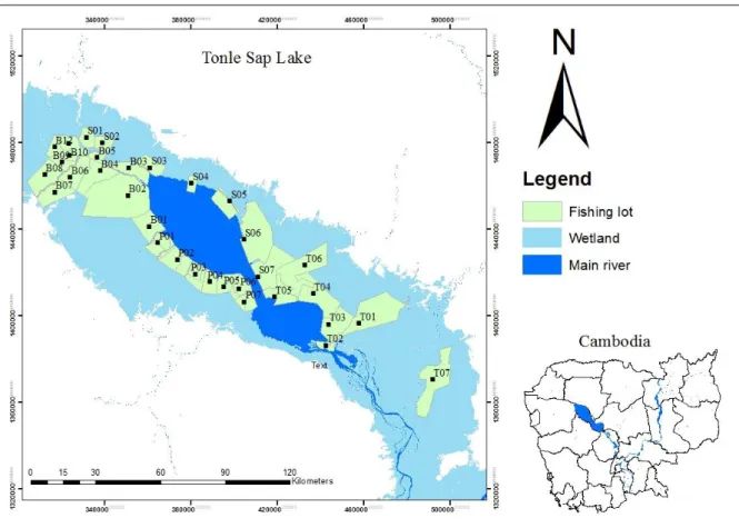
This study covers the Tonle Sap System (TSE): Tonle Sap Lake and Tonle Sap River (Figure 2.1). Tonle Sap Lake is situated in the central of Cambodian consisting of the largest wetland area in Southeast Asia and covers about 5 to 8 percent of the total land area (Matti Kummu & Sarkkula, 2008; MRC, 2003, 2005). Tonle Sap Lake and the Mekong River are connected by Tonle Sap River (TSR) with 120 km long (M. Kummu et al., 2014). This study covers the spatial range approximately 300 x 300 km.
2.2 Data collection
This study uses three different datasets: catch assessment data of fishing lots, catch assessment data of mobile gear fishing, and catch monitoring survey data. The fish data were provided by the Fisheries Programme of the Mekong River Commission (MRC) in collaboration with the Cambodian Department of Fisheries (currently called the Fisheries Administration [FiA]) and financially supported by the DANIDA (Danish International Development Agency) (Ly and VanZalinge, 1998).
For catch assessment data of fishing lot, fish were collected from thirty-three fishing lots around TSL (Figure 2.1). Noticed that fishing lots are good fishing area demarcated by the government and give to the private sectors or fishers for commercial fisheries operation (Ly and VanZalinge, 1998). At each lot, the sampling was conducted during weekly sampling of thirty-three fishing lots around the lake from October to May each year from 1994-2000. The sampling method was designed and approved by the Department of Fisheries with technical support from MRC experts. At each lot, samplings were conducted by the provincial fisheries scientists and supervised by central fisheries scientists from the Cambodian Department of Fisheries. Herein, data collectors were trained in the basic concepts of sampling,
27 identification and data record. With the heterogeneity and complexity of habitat in the fishing lot, many types of fishing gears were applied according to the specific habitat characteristic. For instance, the river barrages with U-shaped bag-nets were used for riverine fishing lots, and arrow-shaped bamboo fence traps for the lake floodplain fishing lots to maximise the catches. The catch assessment attempted to estimate the maximum catches within each fishing lot. Fish were identified to species and identification was based on the consultation with MRC experts following the keys in (Rainboth, 1996). Complete details on the fish sampling techniques and the catch assessment data are available in Ly & VanZalinge (1998). This data was used to study the spatio-temporal changes in the fish assemblage (chapter III) and the influence of the environmental factors on the distribution of fish species (chapter IV).
For catch assessment data of mobile fishing gear, the fish biomass data were monthly collected from TSL and TSR from 1994 to 2000. Here, the mobile fishing gear refers to the fishing that commonly used at the small-scale fishing at the family level (Deap, Degen, & VanZalinge, 2003). The sampling method was designed and approved by the Department of Fisheries with technical support from MRC’s expert. The data were collected by local fishermen, and they were trained in the basic concepts of gears, specific terminology, technical drawing and reporting (Deap et al., 2003). Samplings were conducted on a daily basis from 1995 to June 2000 around TSL. In this study, we selected the fish data collected from the gill net with mesh size of <7 cm. Identification was based on the common names combined with a review of previous studies and consultation with MRC’s experts; further, identification followed the keys in Rainboth (1996). This dataset was used to compare overall fisheries and fish community and structure before and after fishing lot abolishment (chapter VI).
For catch monitoring survey data, time series data were daily collected from January 2012 to December 2015 at three sampling sites in the TSE (as indicated in red circle dot), one of which is located in the northern TSL (hereafter abbreviated to “NL”), one in the southern TSL (abbreviated to “SL”), and the other one in the outlet river (abbreviated to “OR”) of TSR
28 (Figure 2.1). The catch monitoring approach follows the MRC’s regional monitoring method applied in the Lower Mekong Basin (MRC, 2008; P.B. Ngor, Theng, Phem, & So, 2014). The catch monitoring approach follows the MRC’s regional monitoring method applied in the Lower Mekong Basin (MRC, 2008; P.B. Ngor et al., 2014). At each sampling site, nylon gillnets with 2 to 6.5 cm mesh sizes were used to capture as many fish species as possible (P.B. Ngor et al., 2014). Gillnets have been considered the most common and popular fishing gear used in the TSE and are suitable to be applied in different habitat types (MRC, 2008). The gillnets used had a length of 400 m ± 100 m (P.B. Ngor et al., 2014). The variation in the gillnet length is due to the habitat availability (e.g., inundated forest, open water of TSL, river, streams, and creeks), which varies according to the annual hydrological cycle. Fishes were identified to the species level following the identification guide by Rainboth (1996) and enumerated and recorded in a logbook. The logbooks were then collected from fishers on a quarterly basis and cross-checked by research specialists. Unidentified species were later identified by an expert taxonomist in the laboratory. This data was used for chapter V and VI.
Moreover, the morphological traits and trophic level position of 55 fish species were derived from the FishBase (Froese & Pauly., 2017). The information about biological traits of fish species (i.e. migration, the position of water column) was reviewed and derived from (Froese & Pauly, 2017; Peng Bun Ngor, Legendre, Oberdorff, & Lek, 2018; Poulsen et al., 2004). The migration and water column were orderly coded according to the characteristics. These attribute information were used for chapter VI.
Regarding the environmental parameters, the local habitat, climatic feature and water level were used. The surface area of land-cover types of each fishing lot was calculated from the Cambodian Land Use 1993 map that best fits the fish catch period (1994-2000)(used for chapter IV). Three land-cover types were considered: flooded forest (FF), open water (OW), and agricultural field (AF). Land cover was expressed as a percentage of coverage of each fishing lot. Additionally, nineteen bioclimatic variables were extracted from the 1-km2
-29 resolution WorldClim layers for the period 1950-2000 (Hijmans et al. 2005). Despite the limited spatial range of this study (approximately 200 x 200 km), climate variables demonstrated substantial variations across the lake; thus, these variables are relevant for analysing the correlations between fish biomass and climate features (chapter V). Moreover, the water level data measured from site WS1 was analysed with the fish data collected from the NL and SL sites, whereas that from WS2 was analysed with the fish data collected from the OR site (in chapter VI).
Figure 2.1 Map showing the fishing lots surrounding the floodplain of Tonle Sap Lake in
Cambodia. “Wetland” refers to the flooded area during the wet season. The first letter in the code represents the province name: B (Battambang), S (Siem Reap), P (Pursat) and T (Kampong Thom) and is followed by the lot numbers in each province. Sampling sites (red dots) of the study area: NL, the northern TSL; SL: the southern TSL; OR, the outlet river of Tonle Sap River. WS1: water measurement station (red dot with a cross), WS2: the water measurement station situated at the same location as the “OR” fish sampling site.
30
2.3 Statistical analyses 2.3.1 Community clustering
Hierarchical clustering based on the Euclidian dissymmetry distance on the NMDS scores with Ward linkage method allowed to identify the fish assemblages (in chapter III only). Hierarchical cluster analysis in combination with multiscale bootstrapping generated probabilities was applied to investigate consistent spatial distribution patterns within the eight species (in article 3). For this study, the Bray–Curtis dissimilarity measures were compared for each grouping of the analysis (Bray & Curtis, 1957). For each measure of dissimilarity, the distance was calculated with Ward’s linkage to compare the measures of dissimilarity for consistent grouping.
2.3.2 Comparative analysis
A Mann-Whitney test was used to test for significant differences between the two groups. Here, we used Mann-Whitney to test for significant difference in fish yields and species richness between the two assemblages (chapter III).
2.3.3 Predictive models
Linear models were used to detect temporal trends in yields of the most dominant fish species, the total fish yields of TSL over the past six years, and the relationship between fish yields and coefficient of variation in the water level (chapter III).
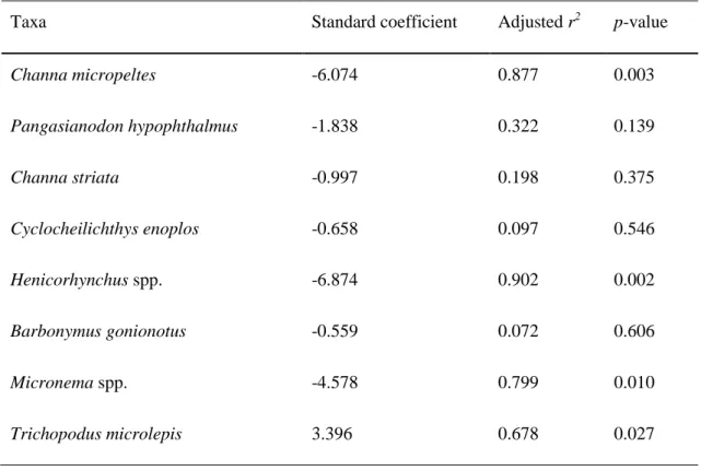
Moreover, generalised linear models (GLM) were used to investigate the relationships between the spatial distribution of each species and the local habitat and regional climatic factors (article 3). GLM is an extension of linear regression. Before building the GLM models, the explanatory variables of the local habitat and regional climatic variables were to normalised get the same scale of the variable. The response was the mean value of the annual
31 biomass of each species. Step-wise approach with both backward and forward selection was applied to remove unimportant variables.
2.3.4 Multivariate analyses
Non-metric multidimensional scaling (NMDS) with Bray–Curtis similarities distance (Bray & Curtis, 1957) was performed to visualise sample of fish in a two-dimensional plot. For instance, NMDS was performed to illustrate the spatio-temporal change in the fish community (in chapter III) and a change in fish community composition between the BFA and AFA (in chapter VI), utilising the “vegan” package in R (Oksanen et al., 2015). The NMDS is a rank based method attempting to represent the pairwise dissimilarity between sampling units in a two-dimensional space. Stress ranges from 0 to 1 and any value less than 0.15 indicates a good fit (Clarke, 1993). In addition, three things the size of the convex hull, position (centroid) and structure were applied to test.
A principal component analysis (PCA) was performed to relate the status of fish species (i.e. decreasing, increasing, and non-change) to the morphological and biological traits (in chapter VI). The analysis allows us to say something about the changes that were related to some specific groups or functional traits and size class of fish species.
Analysis of similarity (ANOSIM, Clarke, 1993) was also used to test for significant difference in fish community composition between the two periods: before and after fishing lot abolishment. ANOSIM is a nonparametric multivariate procedure broadly analogous to analysis of variance (ANOVA) that has been widely used for testing whether or not groups of sites are statistically different with respect to their relative similarities in the community composition (Clarke, 1993). ANOSIM was conducted on Bray–Curtis dissimilarities matrix calculated among samples (Oksanen et al., 2015). The significance of the ANOSIM results was assessed according to the statistic-R value (correlation coefficients between groups) which provides a measure of effect size and a P-value (significant difference between groups) of the