HAL Id: hal-01128681
https://hal.archives-ouvertes.fr/hal-01128681
Submitted on 10 Mar 2015HAL is a multi-disciplinary open access archive for the deposit and dissemination of sci-entific research documents, whether they are pub-lished or not. The documents may come from teaching and research institutions in France or abroad, or from public or private research centers.
L’archive ouverte pluridisciplinaire HAL, est destinée au dépôt et à la diffusion de documents scientifiques de niveau recherche, publiés ou non, émanant des établissements d’enseignement et de recherche français ou étrangers, des laboratoires publics ou privés.
European software tools for mapping Wildland Urban
Interfaces in the Mediterranean context
C. Bouillon, M.M. Fernández Ramiro, C. Sirca, B. Fierro García, M. Long
Fournel, F. Casula
To cite this version:
C. Bouillon, M.M. Fernández Ramiro, C. Sirca, B. Fierro García, M. Long Fournel, et al.. European software tools for mapping Wildland Urban Interfaces in the Mediterranean context. Modelling Fire Behaviour and Risk, Universita di Sassari DIPNET, pp.243-248, 2012, ISBN 978-88-904409-7-7. �hal-01128681�
Modelling
Fire
Behaviour
and Risk
Eds. Donatella Spano,
Valentina Bacciu,
Michele Salis,
Costantino Sirca
Supported by PROTERINA-C
Project EU Italia-Francia Marittimo
2007-2013 Programme
Modelling Fire Behaviour and Risk
Supported by PROTERINA-C Project:
A forecast and prevention system for climate change impacts
on risk variability for wildlands and urban areas
(EU Italia-Francia Marittimo
2007-2013 Programme)
Editors
Donatella
Spano
Valentina
Bacciu
Michele
Salis
Costantino
Sirca
Department of Science for Nature and Environmental Resources (DipNeT), University of Sassari, Italy;
Euro-Mediterranean Center for Climate Changes (CMCC), IAFENT Division, Sassari, Italy
ISBN
978-88-904409-7-7 Supported by Under the patronage of
Printed by Nuova StampaColor S.r.l. Industria Grafica Zona Industriale Muros 07030 Muros (Sassari, Italy) PROTERINA-C Project EU Italia-Francia Marittimo 2007-2013 Programme
Graphic Design and Layout
Valentina Bacciu and Michele Salis
Cover Photo by
Sandro Tedde
www.sandrotedde.com
Fires and Wildland Urban Interfaces
243
European software tools for mapping Wildland Urban
Interfaces in the Mediterranean context
Bouillon C.1, Fernández Ramiro M.M.2, Sirca C.3,4, Fierro García B.2, Long-Fournel M1., Casula F.3
1Cemagref, UR EMAX, 3275 route de Cezanne, CS 40061, 13182 Aix-en-Provence cedex 5; 2Tragsatec, C/Julián Camarillo 6B, 1B, 28035, Madrid, Spain; 3DipNET- Dipartimento di
Scienze della Natura e del Territorio, University of Sassari, Via E. De Nicola, 9 – 07100 – Sassari, Italy; 4Euro-Mediterranean Center for Climate Changes, IAFENT Division,
Sassari, Italy
christophe.bouillon@cemagref.fr, mfra@tragsa.es, cosirca@uniss.it
________________________________________________________________________ Abstract
This paper aims to present a software tool allowing to map Wildland-urban interfaces (WUI) on local and global scales. Two methods have been produced for mapping WUI on local scale (one or several district level) and one method for the broad scale (European level). These works are part of the European FUME project (7th Framework Program). The two methods for local mapping were developed by Cemagref/Irstea, and Tragsatec, and were tested by DipNET (University of Sassari) in three study areas which are located in South-Eastern France, in Eastern Spain, and Sardinia (Italy). The UNISS team uses the WUImap software for mapping WUI on local and European levels. The aim is to evaluate changes in time of main WUI descriptors. The software is designed to work with ESRI Arc GIS 9.3, ArcInfo license.
Keywords: WUI, RUI, geography, GIS, forest fire 1. INTRODUCTION
The main purposes of this work are:
1) to set the WUI mapping methods on different scales (local and global scales) according to available data and local contexts;
2) to present a developed easy-to-use WUImap toolbox giving an automatic mapping of WUI using GIS;
3) to provide guidelines for using the tool, including customization of inputs.
Cemagref/Irstea and Tragsatec have developed different approaches for characterizing WUI at local and global scales.
On local scale, both these approaches seem to be efficient and complementary. Their usefulness and applicability depend on the available data on local or regional scale. A toolbox able to manage the two methodologies gives the opportunity to choose between them. The approach has to be selected according to the availability of data for the examined area, and to the context of the country.
For the global scale, corresponding to the European scale, only one method has been implemented and proposed by the two partners Cemagref/Irstea and Tragsatec. The principal input data for the global tool is the Corine Land Cover. Another database is also
Fires and Wildland Urban Interfaces
244
used to improve the information about dwellings, urban structures, infrastructures: the Soil Sealing Europe produced by the Join Research Center, the European Commission in-house science service.
2. METHODS FOR WUI MAPPING
2.1. Mapping at local scale: Cemagref/Irstea's method
The characterization of Wildland-Urban Interfaces is necessary to improve actions for forest fire prevention. In France, forest fire prevention is generally based on a legislative framework. Key points include the brush clearing obligations for homeowners around their houses but also for communities and public establishments around buildings and near the roads. As more than 90% of well-known causes of forest fire ignition are due to human activities (especially carelessness), prevention actions must be enhanced by and for inhabitants involved in fire risk (in many cases people living in the WUI).
Cemagref/Irstea has implemented a method to map WUI on local and regional scale (Lampin-Maillet et al. 2010). This method is an improvement of a previously developed tool and guide to map WUIs, a result of the FIREPARADOX European project (6th Framework Program).
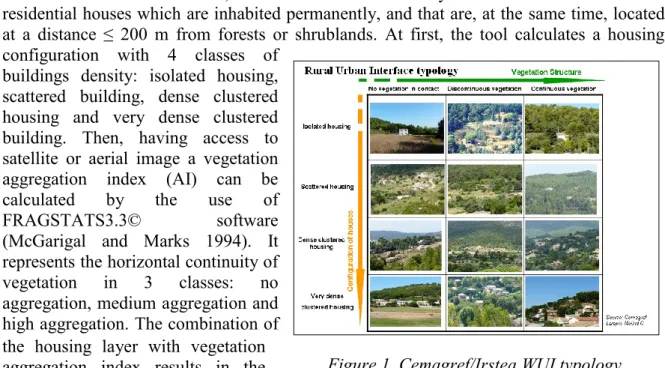
The method considers WUIs, all the areas delineated by a radius of 100 m around residential houses which are inhabited permanently, and that are, at the same time, located at a distance ≤ 200 m from forests or shrublands. At first, the tool calculates a housing configuration with 4 classes of
buildings density: isolated housing, scattered building, dense clustered housing and very dense clustered building. Then, having access to satellite or aerial image a vegetation aggregation index (AI) can be calculated by the use of FRAGSTATS3.3© software (McGarigal and Marks 1994). It represents the horizontal continuity of vegetation in 3 classes: no aggregation, medium aggregation and high aggregation. The combination of the housing layer with vegetation aggregation index results in the typology with 12 classes (Figure 1).
2.2. Mapping at local scale: Tragsatec’s method
According to Regional Forest Law, only settlements located within a distance of 400 m from the forested areas are to be considered WUIs. In fact, this value determines the forest influence zone. This parameter can be modified in the tool according to the laws of each country. Moreover, the forest fire management actions are under the responsibility of the Autonomous Regions; therefore there is not a national general rule on the prevention of forest fires in the WUI areas. One of the responsibility of the Forest fire management is the execution of an analysis about how the settlement and structural characteristics of forest
Fires and Wildland Urban Interfaces
245
ecosystems interact, creating different types of WUI. Each Interface must be provided with a tailored strategy. So in order to achieve the objective to protect the population against forest fires, it is first necessary to know how the population inhabits the land. The location and the type of the settlements are indispensable land descriptors in order to give a fast, coordinate and efficient answer in case of emergency.
TRAGSATEC has worked out in the characterization of WUIs. The Spanish method is structured in three stages: a settlement map creation, a buffering according to the settlements and land uses types, and a WUI type map creation.
In the first step, the various types of settlements are characterized and located in the Settlement map. Then, using this first output, different types of WUI are identified and located through a buffering. The creation of the final WUI map takes in account, first, the type of settlement (the buffer radius depends on it) and then, the vegetation-settlement connection around houses (the context in which the settlement is situated).
Two layers are required as inputs to generate the settlement maps: a Land Use layer to evaluate the urban zones and buildings (in the case of Spain it has been used the SIGPAC map with a 1:5,000 scale of photo interpretation), and a Vegetation Cover layer to evaluate the context in which settlement are located (in the case of Spain it has been used the National Forest Map of Spain -MFE50- whose scale is 1:15,000).
The size of the buffer created around the established settlements depends on the difficulty in protecting the houses against fire: Urban Settlement = 400m; Settlement in Forested Areas = 300m; Settlement in Agricultural Areas = 200m; Dispersed Buildings in Forested Areas = 300m; Dispersed Buildings in Agricultural Areas = 100m; Isolated Buildings in Forested Areas = 200m; Isolated Buildings in Agricultural Areas = 100m. The different types of WUI are defined according to the type of settlement and vegetation-settlement connection around houses (Table 1). A final buffer for each type of vegetation-settlement defines the Wildland-urban interface surface.
2.3. Mapping at global scale
The method has been developed to produce a map at the global European scale. The best available data on the European level to create a continental map is the Corine land cover. It has been decided to improve the precision of urban plots by combining it with the European soil sealing. The module, implemented by Cemagref/Irstea, calculates a WUI map on the European scale (100m pixel) combining improved housing in 3 classes: isolated, scattered, dense clustered with vegetation in 3 classes: mineral, agriculture or sparse vegetation, forested area.
3. RESULTS
The modules corresponding to the French part and the Spanish part of the tool were tested in Sardinia (Italy) by DipNET. The data came from 3 test sites.
Fires and Wildland Urban Interfaces
246
3.1. Local scale
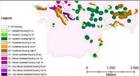
3.1.1. The Cemagref/Irstea method: Figure 2 presents a detail of the WUI Type map in Alghero municipality (NW Sardinia) made by DipNET. It shows all the 12 classes generated and the general housing configuration of the area.
The French method is based on a 100 m buffer, corresponding to the maximum value that the French law sets for the brush clearing zone around the houses.
Figure 2. Map of WUI in the Western part of Alghero area (Cemagref/Irstea method)
The tool is also able to calculate maps on large areas. DipNET has developed the housing configuration map (first output of the tool) of north east Sardinia (~3200 km2). The calculation tests are continuing on the NW of Sardinia and are not over yet. A validation test is completed for the whole method in several municipalities in the Marseille-Aix region.
3.1.2. The Tragsatec's method: Figure 3 shows all the 7 WUI Types emerging from the housing density and the settlement surrounding environment according to the Spanish method.
3.2. Global scale
The Figure 4 shows the 9 global WUI types calculated by the global tool using the Corine Land Cover and the Soil Sealing European database.
4. CONCLUSIONS
The outputs produced by the tool were compared and a significant consistency between the obtained maps was observed. The direct knowledge and some surveys in the territory to visually compare the outputs with the real situation enable us to verify a clear agreement between the software result and the WUI distribution on the territory.
The two approaches, global and local, are both useful to know, describe and map the territory on different scales and level of definition. The map that the global tool produces
Fires and Wildland Urban Interfaces
247
can be used to have a general view of the territorial characteristics on regional scale and to focus the areas where the use of the local tool would complete the analysis.
In a general interpretation of the local tool application, the CEMAGREF/IRSTEA and TRAGSATEC methodologies could be considered as complementary. The first method developed by Cemagref/Irstea analyses the residential buildings and the presence/continuity of vegetation. The Tragsatec methodology also works on dwellings but it considers the environment in which they are located, forested, urban or agricultural. More information can be collected and a more complete description of single WUI contexts can be obtained by running the local tool with both methods. The use of the tool could be very advantageous for fire risk analysis on WUI scale and for local quantification of fuels charge and continuity. The information and the direct knowledge of the general context are both very important for the local fire risk assessment.
Figure 3. Map of WUI in the Western area of Alghero (Tragsatec method).
Fires and Wildland Urban Interfaces
248
5. REFERENCES
Caballero D., Beltran I., 2003. Concepts and ideas of assessing settlement fire vulnerability
in the WUI zone. In Proceedings (Eds Xanthopoulos, G.) of the international workshop
WARM, Forest fires in the wildland-urban interface and rural areas in Europe: an integral planning and management challenge. Athens, Greece. pp 47-54.
Cohen J.D., 2002. Wildland-urban fire - A different approach. In: Proceedings of the Firefigther Safety Summit, International Association of Wildland Fire Missoula, MT. Lampin-Maillet C. Bouillon C., 2010. WUImap© Cemagref/Irstea 2010: Tool for mapping
Wildland-urban interfaces, User’s notice included in the deliverable called P.5.2-8 of
the European project “Fire Paradox”.
Lampin-Maillet C., 2009. Caractérisation de la relation entre organisation spatiale d’un
territoire et risque d’incendie: Le cas des interfaces habitat-forêt du sud de la France.
Thèse de doctorat de l’université Aix-Marseille, mention Lettres et Sciences humaines (Géographie- Structures et dynamiques spatiales). 325 pages + annexes.
Lampin-Maillet C., Bouillon C., 2011. WUImap: a software tool for mapping
Wildland-urban interfaces at a large scale over a large area in Mediterranean European context.
Journal of Environmental Science and Engineering, 5, (2011) 1-4
McGarigal K., Marks B., 1994. Spatial patterns analysis program for quantifying
landscape structure. FRAGSTATS version 2.0. Forest Science Dept, Oregon State
Univ., Corvallis, OR, USA.
Stewart S.I., Radeloff V.C., Hammer R.B., Hawbaker T.J., 2007. Defining the