HAL Id: hal-00975341
https://hal.archives-ouvertes.fr/hal-00975341
Submitted on 15 Apr 2015
HAL is a multi-disciplinary open access
archive for the deposit and dissemination of
sci-entific research documents, whether they are
pub-lished or not. The documents may come from
teaching and research institutions in France or
abroad, or from public or private research centers.
L’archive ouverte pluridisciplinaire HAL, est
destinée au dépôt et à la diffusion de documents
scientifiques de niveau recherche, publiés ou non,
émanant des établissements d’enseignement et de
recherche français ou étrangers, des laboratoires
publics ou privés.
Amazon: a case study of daytime observations in a
complex atmospheric scene
F. Marenco, V. Amiridis, E. Marinou, A. Tsekeri, Jacques Pelon
To cite this version:
F. Marenco, V. Amiridis, E. Marinou, A. Tsekeri, Jacques Pelon. Airborne verification of CALIPSO
products over the Amazon:
a case study of daytime observations in a complex atmospheric
scene. Atmospheric Chemistry and Physics, European Geosciences Union, 2014, 14, pp.11871-11881.
�10.5194/acp-14-11871-2014�. �hal-00975341�
www.atmos-chem-phys.net/14/11871/2014/ doi:10.5194/acp-14-11871-2014
© Author(s) 2014. CC Attribution 3.0 License.
Airborne verification of CALIPSO products over the Amazon: a
case study of daytime observations in a complex atmospheric scene
F. Marenco1, V. Amiridis2, E. Marinou2, A. Tsekeri2, and J. Pelon3
1Observational Based Research, Met Office, Exeter, UK
2Institute for Astronomy, Astrophysics, Space Applications and Remote Sensing,
National Observatory of Athens, Athens, Greece
3UPMC-CNRS/INSU-UVSQ, LATMOS, 4 Place Jussieu, 75252 Paris CEDEX 05, France
Correspondence to: F. Marenco ([email protected])
Received: 10 March 2014 – Published in Atmos. Chem. Phys. Discuss.: 4 April 2014 Revised: 3 October 2014 – Accepted: 9 October 2014 – Published: 12 November 2014
Abstract. A daytime underflight of CALIPSO with the
Facil-ity for Airborne Atmospheric Measurements was performed on 20 September 2012 in the Amazon region of Brazil, dur-ing the biomass burndur-ing season. The scene is dominated by a thin elevated layer (aerosol optical depth (AOD) 0.03 at 532 nm) and a moderately turbid boundary layer (AOD ∼ 0.2 at 532 nm). The boundary layer is topped with small broken stratocumulus clouds. In this complex scene, a comparison of observations from the airborne and spaceborne lidars re-veals a few discrepancies. The CALIPSO detection scheme tends to miss the elevated thin layer, and also shows several gaps (∼ 30 %) in the boundary layer. The small clouds are not correctly removed from the signals; this can cause the CALIPSO aerosol subtype to oscillate between smoke and polluted dust and may introduce distortion in the aerosol re-trieval scheme. The magnitude of the average extinction co-efficient estimated from CALIPSO Level 2 data in the bound-ary layer is as expected, when compared to the aircraft lidar and accounting for wavelength scaling. However, when the gaps in aerosol detection mentioned above are accounted for, we are left with an overall estimate of AOD for this particu-lar scene that is of the order of two thirds of that determined with the airborne lidar.
1 Introduction
Biomass burning is the second largest source of anthro-pogenic aerosols on Earth (Houghton et al., 2001). The Fourth Assessment Report of the Intergovernmental Panel on
Climate Change reports a global radiative forcing (RF) con-tribution of roughly +0.03 ± 0.12 W m−2for biomass burn-ing aerosols (Forster et al., 2007), whereas the Fifth Assess-ment Report estimates this contribution to be ±0.2 W m−2 (Stocker et al., 2013). Textor et al. (2006) showed that there are still significant uncertainties in the aerosol vertical dis-tribution in global models, whereas this information is crit-ical in assessing the magnitude and even the sign of the di-rect RF. Of particular interest are the distribution of lofted layers (Mattis et al., 2003; Müller et al., 2005; Baars et al., 2012) and the identification of complex scenes involving both aerosols and clouds (Chand et al., 2008). The large amount of heat released by forest fires can generate strong updrafts and deep convection in their vicinity, with a rapid transport of aerosols to upper layers (Freitas et al., 2007; Labonne et al., 2007; Sofiev et al., 2012). These aerosols, in turn, have an impact on cloud formation, convection, and pre-cipitation patterns (Andreae et al., 2004; Koren et al., 2008). Since 2006 the Cloud-Aerosol Lidar with Orthogonal Po-larization (CALIOP), on board the Cloud-Aerosol Lidar and Infrared Pathfinder Satellite Observations (CALIPSO) satel-lite, has provided an invaluable global data set on the vertical structure of the atmosphere (Winker et al., 2010, 2013). Sev-eral studies have appeared recently, with the goal of eval-uating CALIPSO products using ground-based lidar (Kim et al., 2008; Pappalardo et al., 2010; Tesche et al., 2013), the Aerosol Robotic Network (AERONET) (Mielonen et al., 2009; Schuster et al., 2012; Omar et al., 2013; Lopes et al., 2013), other satellite sensors (Kittaka et al., 2011; Rede-mann et al., 2012; Kim et al., 2013; Jethva et al., 2014),
re-search aircraft (Burton et al., 2013; Amiridis et al., 2012), or comprehensive multi-platform experiments (Kacenelen-bogen et al., 2011; Amiridis et al., 2013).
CALIOP has two operational wavelengths: 532 and 1064 nm, and in the former it has dual polarisation capability (Hunt et al., 2009; Winker et al., 2010). Accurate night-time calibration of the principal channel at 532 nm is obtained via molecular normalisation at stratospheric levels, and the cali-bration is then transferred to the other channels (Powell et al., 2009). As for most lidars, daylight acts as a disturbance to the signal returns, and hence reduces the signal-to-noise ra-tio (SNR), with the consequence that CALIPSO’s night-time data have a superior quality to the daytime data. Scenes with a large planetary albedo, e.g. those with cloud cover, will be dominated by a larger amount of daylight entering the detec-tors, and thus will present an even poorer SNR.
For the first time, a global and fully automated lidar data inversion procedure has been designed. CALIOP’s data anal-ysis package automatically identifies aerosol and cloud lay-ers, and this information is stored as the vertical feature mask (VFM) and atmospheric volume description (AVD) flags (Liu et al., 2009). For aerosol layers, one of six aerosol sub-types is identified (clean marine, dust, polluted continental, clean continental, polluted dust, and smoke), and they deter-mine the extinction-to-backscatter ratio (lidar ratio) based on a look-up table (Omar et al., 2009). Using the lidar ratio (and its uncertainty associated with the identified aerosol sub-type), extinction and backscatter profiles are computed using the Hybrid Extinction Retrieval Algorithms, HERA (Young and Vaughan, 2009; Young et al., 2013). This is an iterative method that solves the lidar equation for a two-component atmosphere, with an integration that starts at the top of the atmosphere and works its way down to the surface. However, the outward solution of the lidar equation can lead to mathe-matical instability and divergence (Fernald, 1984; Marenco, 2013), and in the attempt to keep these unwanted effects un-der control, a mechanism for iterative adaptation of the lidar ratio is applied when such instabilities are detected (Young and Vaughan, 2009; Young et al., 2013). This marks a differ-ence with the classical outward solution with a pre-assigned lidar ratio; the latter is decreased as is needed to reach stabil-ity and offers the advantage of exploiting the forward inver-sion down to the surface, in terms of vertical exteninver-sion.
In this paper we examine an underpass of the CALIPSO satellite by the Facility for Airborne Atmospheric Measure-ments (FAAM) BAe-146 research aircraft, during a daytime flight in the Amazon basin during the biomass burning sea-son. Although limited, this data set gives a good insight on some critical aspects that may be associated with CALIPSO retrievals and the characterisation of aerosol subtypes.
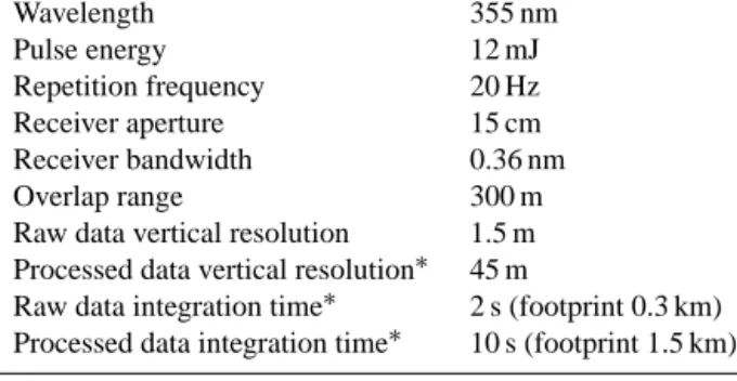
Table 1. Technical specifications of the Leosphere ALS450 lidar on board the FAAM aircraft. Footprints are computed for a typical aircraft speed of 150 m s−1. Wavelength 355 nm Pulse energy 12 mJ Repetition frequency 20 Hz Receiver aperture 15 cm Receiver bandwidth 0.36 nm Overlap range 300 m
Raw data vertical resolution 1.5 m Processed data vertical resolution∗ 45 m
Raw data integration time∗ 2 s (footprint 0.3 km) Processed data integration time∗ 10 s (footprint 1.5 km) ∗user-configurable parameter.
2 Aircraft observations
In September and October 2012 the South AMerican Biomass Burning Analysis (SAMBBA) campaign was car-ried out in Brazil, and several observations were made dur-ing 20 science flights usdur-ing both in situ and remote sensdur-ing techniques (Angelo, 2012; Johnson et al., 2013). Significant aerosol loading has been found during most of the flights, and in the majority of cases it has been ascribed to smoke origi-nating from forest fires, as confirmed by a variety of measure-ments. In situ observations with wing-mounted optical parti-cle counters (PCASP and CDP; see Liu et al., 1992; Lance et al., 2010) showed a predominance of fine mode particles. Moreover, measurements with the on board AL 5002 VUV Fast Fluorescence CO Analyser (Gerbig et al., 1996, 1999; Palmer et al., 2013) showed high carbon monoxide concen-trations. No strong depolarisation signal has been observed in the aircraft lidar returns, except when observing opti-cally thick layers where multiple scattering is non-negligible (clouds and very thick smoke). A general feature through-out the campaign was the persistence of aerosols above the boundary layer, with thin plumes up to altitudes of 5–7 km, presumably due to lifting via deep convection.
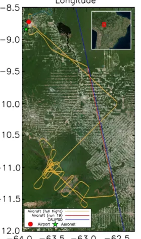
On 20 September a complex flight was carried out, tak-ing off from Porto Velho, Brazil, and flytak-ing over the Amazon for three hours and 45 min (flight number B737, see Fig. 1). Most of the flight was devoted to characterising a large natu-ral wildfire, but towards the end a 230 km long underpass of CALIPSO was performed (this distance was covered in 33 s by CALIPSO, and 24 min 30 s by the aircraft). This paper focuses on the latter part of the flight (Run 19), when clouds and aerosol layers have been mapped with the airborne lidar looking down from 6500 m.
An ALS450 lidar system, manufactured by Leosphere, was used on board the aircraft, looking down at nadir (Marenco et al., 2011). For a description of the lidar system, see Chazette et al. (2012); see also Table 1 for the system’s specifications. The receiver implements two channels, for the
Figure 1. Yellow line: full flight track of the BAe-146 aircraft on 20 September 2012 (flight B737). Red line: aircraft track for the flight section between 17:49:20 and 18:12:46 UTC (Run 19). Blue line: CALIPSO footprint on the same date, between 18:00:37 and 18:01:41 UTC. Porto Velho is marked near the top left corner: red circle, airport; green star, AERONET site.
detection of the elastic backscatter in both the co-polar and the cross-polar planes, relative to the emitted radiation. Un-fortunately, the system suffers large temperature variations during a research flight, which strongly affects the sation signal; for this reason it is not possible to use depolari-sation quantitatively (it cannot be calibrated) and depolarisa-tion informadepolarisa-tion is used qualitatively. For non-depolarising aerosol layers, this is believed to have little impact on the retrieved extinction profile.
Lidar signals have been acquired with an integration time of 2 s (40 laser shots) and a vertical resolution of 1.5 m; to reduce random noise, all vertical profiles have been fur-ther smoothed with a 30-point running average. The range-corrected lidar signal that is displayed in the present pa-per has, therefore, a horizontal resolution of 0.3 km (2 s at
∼150 m s−1, speed of the aircraft) and a vertical resolu-tion of 45 m. For this product, the SNR is larger than ∼ 5 on the whole atmospheric column, for a daytime cloud-free profile with moderate aerosol load (aerosol optical depth, AOD ∼ 0.3), when looking down from an altitude of 6500 m.
Lidar signals have been integrated to a 10 s resolution (1.5 km footprint) for further analysis. Cloud screening has been performed by discarding whole vertical profiles at the 10 s resolution, if they contained cloud signals, where clouds have been automatically detected using the thresholds given in Osborne et al. (2014) and Allen et al. (2014), and have been manually validated after a profile-by-profile signal in-spection. The remaining lidar signals have then been pro-cessed with the method described in Marenco (2013), us-ing a lidar ratio of 75 sr, appropriate for biomass burnus-ing aerosols (Baars et al., 2012; Groß et al., 2012); this process-ing is achieved for whole vertical profiles at once.
Finally, to offer a better comparison with the CALIPSO product, the extinction coefficient obtained with the air-craft lidar has been converted to 532 nm; the conversion is achieved by applying a colour ratio 0.57±0.01, derived from the nearby AERONET station in Porto Velho (mean and stan-dard deviation of the direct-sun measurements taken on 20 September). This wavelength conversion has to be consid-ered approximate, because the spectral absorption properties of the aerosols may vary; moreover, the AERONET site is lo-cated ∼ 200 km to the Northwest (see, Anderson et al., 2003 for the coherent spatial scales of extensive aerosol proper-ties). We believe, however, that this approach is reasonable because (i) our flights over the Amazon have shown a large degree of coherence of the regional haze over distances of several hundreds of kilometres, and (ii) colour ratio is an intensive property of the aerosols, and thus presumed to be consistent over large scales than the extensive properties. The colour ratio we have found is compatible with the wavelength dependence derived by Baars et al. (2012) using Raman li-dar data, since that article indicates an Ångström exponent of 1.17 ± 0.44, which corresponds to a colour ratio 0.62 ± 0.11.
3 Results
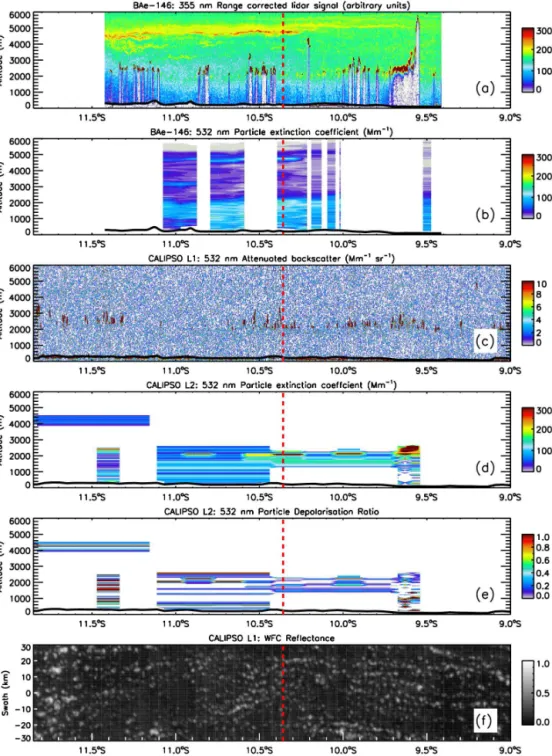
Figure 2a shows the range corrected signal measured from the airborne lidar at 355 nm. A thin elevated aerosol layer is highlighted at 4500–5000 m with some other thinner layers underneath it but well above the boundary layer. The ele-vated layer was observed by lidar during all the high alti-tude portions of this flight. At the top of the boundary layer (∼ 2.2 km), a series of small broken clouds can be seen (stra-tocumulus), displayed in dark red since their lidar returns are very large and saturate the colour scale. The size of the clouds can be estimated from the airborne lidar: their along-track horizontal extent ranges from ∼ 0.3 to 5 km (median 1.2 km), except for a wider cloudy area at the Northern end that has a horizontal extent of 20 km. Cloud cover is esti-mated to be 36 % (fraction of aircraft lidar profiles where a cloud is detected). Low returns are found in the bound-ary layer (blue colour): one could be mislead into thinking that they could be indicative of a clean layer; however, the opposite is true. The low returns are triggered by
attenua-Figure 2. Latitude–height contour plots of quantities determined with the airborne and the spaceborne lidars: (a) Airborne lidar range corrected signal; (b) Airborne lidar extinction coefficient, converted to 532 nm; (c) CALIPSO 532 nm attenuated backscatter (Level 1 data); (d) CALIPSO 532 nm extinction coefficient (Level 2 data); and (e) CALIPSO 532 nm particle depolarisation ratio (Level 2 data). Panel (f) dis-plays the CALIPSO wide-field camera image in the 620–670 nm wavelength band (Level 1 data, 1×1 km native science data set). The dashed red vertical line indicates where the aircraft is flying closest to CALIPSO (coincidence).
tion through a moderately turbid layer, and are indicative of aerosol load. The information on the aerosol distribution can be better visualised in Fig. 2b, in terms of extinction coef-ficient, which can be interpreted in a more straightforward way. The aerosol signal shows an overall horizontal
homo-geneity over the area under study, but a weak horizontal gra-dient can be observed for the elevated layer (thicker at the Southern end, and nearly indiscernible in the North).
It is interesting to compare this atmospheric structure to the CALIPSO returns, displayed in Fig. 2c in terms of the
532 nm attenuated backscatter (Level 1 data set). It is sur-prising to notice that none of the aerosol layers detected by airborne lidar are evident, and indeed only the cloud returns are apparent. This paper will show, however, that informa-tion about the atmospheric layers is not lost, but when it is displayed in this plot, the aerosol signal is hidden by the am-plitude of shot noise.
Figure 2d shows the result of the inversion into extinc-tion coefficient, as computed with the CALIPSO algorithms (Level 2 data set, version 3.02). This product is designed to yield aerosol properties only, after the removal of cloud sig-nals from the lidar returns. The following observations are made:
– An elevated layer at 4000–4500 m is observed at the
Southern end. However, this layer is not detected at the other latitudes where the aircraft has observed it.
– Boundary layer aerosols are detected, but with some
gaps that are not observed in the airborne data set. The gaps can be found in Fig. 2d from 11.35 to 11.1◦S (whole column); from 10.45 to 9.7◦S (surface to ∼ 1300 m); and from 9.55 to 9.4◦S (whole column). They represent ∼ 30 % of the boundary layer during the un-derflight.
– Large horizontal variations of the extinction coefficient
are observed, mainly at the top of the boundary layer, which seem in contradiction with the general horizontal homogeneity over the region, seen in the airborne data. The first two points can be understood in relation with CALIOP team presentations (Vaughan et al., 2009) and a comment in Pappalardo et al. (2010), where it is stated that not all structures in the CALIPSO Level 1 attenuated backscatter profiles get a representation in terms of Level 2 products, since the identification of features depends on their optical and geometrical properties, as well as the SNR. The SNR could be, for instance, reduced by cirrus above the aerosol layer (Kim et al., 2008); the CALIPSO data set was verified, however, and cirrus is not seen at the latitudes of the underflight with the research aircraft. A thin high cir-rus (not shown here) is observed instead at the Southern latitudes, where the elevated layer is actually found in the Level 2 data as well. The gap between 10.45 and 9.7◦S (be-low ∼ 1300 m) can be better examined in connection with the findings of Vaughan et al. (2010): the CALIPSO version 3 layer detection scheme adds an aerosol base extender al-gorithm. If the base of an aerosol layer is within 2500 m of the surface, it is automatically extended down to the surface, unless the 532 nm integrated attenuated backscatter for the “gap” region is negative. For this profile, however, the Level 1 attenuated backscatter averaged over 80 km is positive and hence the layer base should have been extended down.
Note that the aerosol layers in the CALIPSO Level 2 data set generally show good quality indices for this scene. For
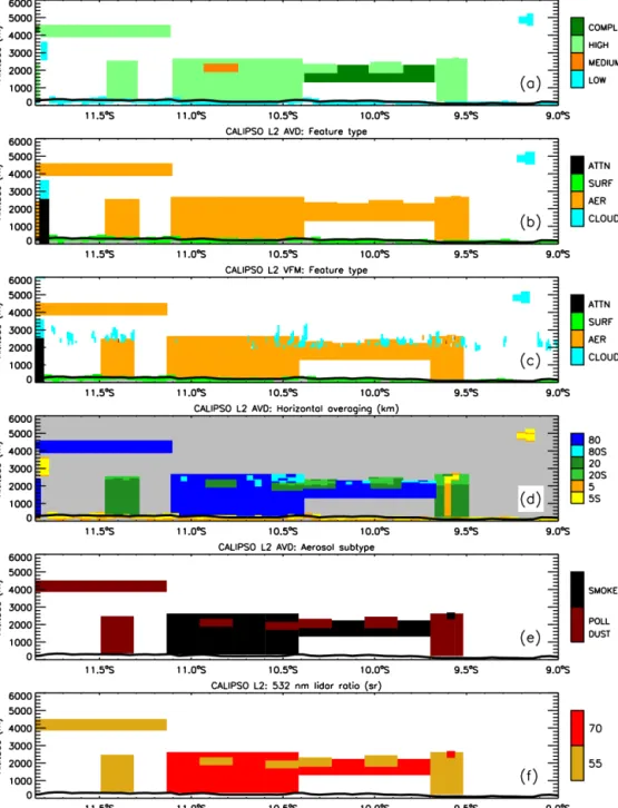
all aerosol layers shown here, the extinction quality control flag is zero, meaning that the retrieval was unconstrained and did not require the iterative adaptation of the lidar ratio, and the extinction uncertainty is less than 0.5 km−1. Moreover, the cloud–aerosol discrimination (CAD) scores, Fig. 3a, sug-gest that there is little doubt about the layer classification as aerosol. The closer to −100 the CAD score, the higher the confidence that the observed layers should be treated as aerosols. All CAD scores for this scene fall below −93, except for the layer displayed in orange colour for which CAD = −74.
Examining only the CAD scores and the feature type given in the AVD flag (Fig. 3b) it could be concluded that cloud contamination of the profiles is negligible. However, this ab-sence of clouds in the AVD feature type at 5 km resolu-tion is misleading. Indeed, low-level clouds were detected by the airborne lidar (Fig. 2a) and are also evident in the Level 1 data set (Fig. 2c). The clouds were also detected by the CALIOP layer detection algorithm, and reported in the VFM, as seen in Fig. 3c, which is a high-resolution (single-shot) version of the AVD product. Moreover, when looking at the CALIPSO wide-field camera (WFC) the underlying cloud field is evident (Fig. 2f). Also, if one examines the AVD product on horizontal averaging, Fig. 3d, the detec-tion of subgrid features at the single-shot level suggests the presence of a highly variable cloud field; this is not indepen-dent information, and it must be taken into account together with the feature type. Clouds detected at single-shot resolu-tion below 4 km are removed from the Level 2 product before the computation of aerosol signals (Vaughan et al., 2009). In Winker et al. (2009) it is specified that boundary-layer clouds and the region of the atmosphere beneath them are identified and removed at single-shot resolution, allowing the retrieval of aerosols when the gaps between clouds are smaller than the required averaging interval. However, in cases where the cloud detection routine fails to identify a cloud (or imper-fectly attributes the cloud boundaries), these clouds will not be removed from the surrounding aerosols layer. In these cases, significant discrepancies can be expected: imperfec-tions of the layer detection algorithms will, in general, affect all the subsequent steps of the processing chain.
Concerning the large variability of the extinction coeffi-cient, mentioned above, some insight can be given by the aerosol subtype, displayed in Fig. 3e. Part of the observed layers are correctly attributed as smoke, but for some layers the CALIPSO retrieval scheme “thinks” that it is in the pres-ence of polluted dust. For each aerosol subtype, a different lidar ratio is assigned, as displayed in Fig. 3f: 70 ± 28 sr for smoke and 55 ± 22 sr for polluted dust (Omar et al., 2009; Lopes et al., 2013). The actual lidar ratio used in the retrieval may in principle be different than the initial one, due to the iterative adaptation applied in HERA in order to prevent di-vergent solutions; however, for this scene such an adapta-tion has not been applied. It is rather evident, by comparison with Fig. 2d, that the classification of what is a homogeneous
Figure 3. Latitude–height contour plots of some additional quantities determined from the CALIPSO Level 2 data set: (a) CAD score confidence level; (b) Feature type, as provided in the AVD flags; (c) Feature type, as provided in the VFM flags; (d) Horizontal averaging in km, as used for retrievals; (e) Aerosol subtype classification; and (f) Lidar ratio assigned for retrievals. An “S” in the horizontal averaging indicates that subgrid features have been detected at single-shot resolution. CAD score confidence levels are as follows: low, CAD > −20; medium, −79 ≤ CAD ≤ −20; high, −99 ≤ CAD ≤ −80; complete, CAD = −100.
smoke layer into different aerosol subtypes is co-located with the large inhomogeneity in the retrieved extinction coeffi-cients. The smoke plume is classified partly as smoke and partly as polluted dust, and when each layer is solved inde-pendently this unexpected result is found.
According to Omar et al. (2009, Fig. 2) the polluted dust type can only occur if the aerosol displays a depolarisa-tion signal. An approximate particle depolarisadepolarisa-tion quan-tity is used, derived from the Level 1 volume depolarisa-tion, and this approximation could lead to overestimation of the actual particle depolarisation and to corresponding
clas-sification uncertainties. Recent validation results using air-borne High Spectral Resolution Lidar (HSRL) co-located measurements show that CALIPSO’s dust layers correspond to a classification of either dust or dust mixtures by the HSRL, and that the polluted dust type is overused due to an attenuation-related depolarisation bias (Burton et al., 2013). In the present study, depolarisation returns from the FAAM lidar show that aerosols observed in the Amazon basin dur-ing SAMBBA are non-depolarisdur-ing; these observations seem confirmed in the CALIPSO Level 1 depolarisation product, although SNR is poor (not shown here).
Examining the Level 2 particle depolarisation product, presented in Fig. 2e, and which is considered more accurate than the approximation used in the aerosol subtyping algo-rithm, we find high depolarisation values. Even recomput-ing depolarisation accordrecomput-ing to Tesche et al. (2013) does not substantially alter the picture, and therefore particle depolar-isation is, in this case, not thought to be dominated by the software bug highlighted in that paper. A large aerosol depo-larisation signal is mainly found in the altitude range dom-inated by the broken low-level clouds, suggesting that the incorrect removal of the cloud signal has left some depolar-isation signal in the aerosol product, causing its misclassifi-cation as polluted dust. In other words, the aerosol subtyping algorithm is affected by the previous steps in the CALIPSO data processing chain and these errors are a case of “garbage in, garbage out” (Omar et al., 2009; Liu et al., 2009). More-over, this is a daytime observation and shot noise is certainly a major source of uncertainty.
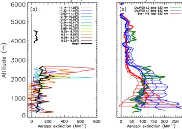
In Fig. 4a all the extinction coefficient profiles are shown for the scene under study, as derived from the CALIPSO Level 2 profile product. This information is equivalent to Fig. 2d, and shows the very large variation in the retrieved profiles discussed above. The mean profile, resulting from spatially averaging the profiles, is shown in black; note that the profiles in this figure all have different horizontal ex-tent, and hence a different weight in the averaging (they are weighed by horizontal extent). The mean profile is also shown in thick green in Fig. 4b, and is compared to the ex-tinction profile derived from the mean aircraft lidar range corrected signal (indicated in red). The aircraft extinction co-efficient shown in Figs. 2b and 4b was determined using the Marenco (2013) method, and has been multiplied by a colour ratio of 0.57 to convert it from 355 to 532 nm. This conver-sion factor was determined from the Porto Velho AERONET site (8◦500S, 63◦560W, located at ∼ 200 km from the aircraft
measurements), where AOD at 18:00 UTC, interpolated for the 355 and 532 nm wavelengths yields 0.55 and 0.31, re-spectively. The uncertainty range in Fig. 4b indicates the ef-fect on the retrieval of an assumed ±50 % error in the far end reference. This error accounts for considering a constant scattering ratio at the reference value, which is true only for a “well-mixed” layer. Its value has not been quantified and can be different than the assumed of ±50 %. As this uncertainty is large near the surface, a verification has been performed
Figure 4. Profiles of aerosol extinction coefficient derived by li-dar: (a) Individual vertical profiles given in the CALIPSO Level 2 data set. Thick black line: average profile for the latitude interval sampled by the aircraft; (b) Green line: average extinction profile from the CALIPSO Level 2 data, for the latitude interval sampled by the aircraft; blue lines: profiles derived from the CALIPSO Level 1 data set; red lines: profiles derived from the aircraft data set and converted to 532 nm. The range of values indicated for the red and blue lines indicates the uncertainty due to the far end reference used for signal inversion, and the thick lines indicate the profiles con-strained with AERONET. Note: for the purpose of constraining to AERONET, the lidar profile is prolonged with the dotted line (con-stant extinction) below the reference height.
using AERONET as a constraint; the red thick line indicates the lidar profile that matches the AERONET AOD (with no change of the lidar ratio). Note that the constrained retrieval is compatible with the unconstrained one; constraining to AERONET is however not a requirement of the method, but it helps reduce the uncertainty. In the boundary layer, the mean of the CALIPSO Level 2 profiles is generally in agree-ment with the aerosol extinction coefficient derived with the aircraft lidar after wavelength conversion.
An additional approach to the CALIPSO extinction re-trieval was attempted, starting directly from the Level 1 data set shown in Fig. 2c. The first step involved cloud screening: all profiles presenting at least a point within the 1500–8000 m altitude range, that has an attenuated backscatter larger than 60 Mm−1in both the 532 nm and the 1064 nm channels, has been entirely removed before further processing. Note that while this simple thresholding scheme is demonstrably ef-fective for this specific data segment, its general use in more complex scenes is not advocated. The remaining profiles (524 out of 671, i.e. 80 %) have been averaged together to determine a mean attenuated backscatter for the scene, and this profile has been smoothed with a six-point running aver-age (resulting vertical resolution: 180 m). The signal has then been inverted into the aerosol extinction coefficient using the Marenco (2013) method, where the far-field boundary
con-dition has been computed by assuming a constant scattering ratio over the 500–1200 m height interval, and the lidar ratio has been assumed to be 70 sr. The result of this procedure is shown in blue, and it is recognised that it offers a reasonable agreement with the latitudinally averaged Level 2 data, when uncertainties are accounted for.
Note that, for both the airborne and the spaceborne lidar, the retrieval constrained with AERONET falls well within the stated uncertainty lines obtained without a constraint. As expected with this method when unconstrained, uncertainty is large near the ground but it decreases when moving up-wards.
Note also that between 2000 and 2800 m the extinction ob-tained for CALIPSO is larger than that obob-tained for the air-borne lidar. A hypothesis is that it could be ascribed to the “twilight zone” consisting of hydrated aerosols in between the boundary-layer clouds (Koren et al., 2007); these hy-drated aerosols could have different optical properties (lidar ratio and colour ratio) so as to introduce this discrepancy.
4 Conclusions
We believe that the data set presented here is a useful com-parison and that it may help identify some critical points and develop further verification experiments. We have high-lighted a particular type of scene, which yields retrieval prob-lems in CALIPSO: the case of broken clouds embedded in a regional haze field, observed in daytime. Problems arise possibly due to the large amount of ambient daylight, lim-iting CALIOP’s SNR. Reflection of light by the clouds am-plifies the upwelling radiation and thus increases this effect; CALIOP’s detection sensitivity may have been reduced be-low specifications for this reason, and this could explain why portions of aerosol layers visible in the aircraft data were not detected. Problems arise as well, because of uncertainties in the cloud–aerosol discrimination and aerosol subtype and li-dar ratio selection algorithms: in this case, depolarisation by undetected boundary layer clouds may have mislead the al-gorithms into believing that dust is present over the Amazon, whereas the region was dominated by smoke.
Moreover, the retrieved aerosol extinction showed an ex-cessive spatial variability. As determined with the aircraft instrument, however, the observed aerosols did not show a large horizontal inhomogeneity. A thin elevated aerosol layer (600 m deep, full width at half maximum) was observed at an altitude of ∼ 5 km, with an AOD of 0.03; a 2.2 km deep boundary layer was also observed, featuring an aerosol ex-tinction coefficient of ∼ 110 Mm−1 and an AOD of ∼ 0.2; the boundary layer is also topped with broken clouds (stra-tocumulus). The air layer between the boundary layer top and the elevated layer also showed aerosol content. From the ob-servations gathered during SAMBBA, evidence exists that the aerosol layers are smoke from biomass burning, and that they do not depolarise backscatter lidar returns.
In this scene, the first remark is that CALIPSO does not de-tect the thin elevated layer. According to the aircraft data set, this layer has a peak backscatter coefficient of 0.8 Mm−1sr−1
at 532 nm (horizontally averaged profile). This has to be compared to Winker et al. (2009, Fig. 4) and Vaughan et al. (2005, Fig. 2.4), where the CALIPSO detection sensitivity for the 532 nm backscatter coefficient at 5 km altitude in day-time is estimated at 1.5, 0.8, and 0.35 Mm−1sr−1for hori-zontal resolutions of 5, 20, and 80 km, respectively: accord-ing to these specifications, the layer should have been de-tected at the coarser resolutions. Note that the daytime sen-sitivity thresholds for feature detection are larger than the night-time ones; this is an effect of the background radiation due to daylight, which acts as a disturbance to the lidar mea-surements. The clouds underneath may have played a role in this failure to detect, as they increase the diffuse daylight background, reducing CALIOP’s SNR and hence detection sensitivity. Vaughan et al. (2005) specify that the above spec-ifications on detection sensitivity apply for a 5 % columnar albedo; in the present scene, dominated by low-level clouds, the average albedo is most probably larger.
The second remark is that the CALIPSO data set displays a variable aerosol subtype in what appears to be a homoge-neous scene. We believe that the presence of broken clouds at the top of the boundary layer misleads the CALIPSO au-tomated processing scheme: if the clouds are incorrectly re-moved, an apparent aerosol depolarisation is detected and the aerosol layer receives a classification as polluted dust, and thus a reduced lidar ratio and a lower extinction. Cases of aerosols being misclassified as dust or polluted dust have also been reported in the literature, but in those studies classifica-tion errors have a different explanaclassifica-tion than in the present case. Kacenelenbogen et al. (2011) have identified an under-estimate of the lidar ratio assigned for retrievals in HERA, due to a misclassification of fine absorbing aerosols as dust or polluted dust, when compared to HSRL; as however no co-incidence with clouds is reported, we believe that the causes of misclassification in that article should be different than those reported here. In Tesche et al. (2013) a similar misclas-sification of marine aerosols was observed in the presence of clouds, but the reason for this was identified to be a software bug, and hence was not ascribed to an incorrect removal of the cloud field. The case illustrated here suggests the incorpo-ration of WFC radiances in the cloud detection scheme could lead to a potential improvement of the final product. More-over, the range bins for which clouds have been detected and removed at single-shot resolution are identified in the AVD product (Fig. 3d): data users could conceivably apply this in-formation to derive more rigorous quality assurance screen-ing criteria.
The third remark is that the boundary layer extinction co-efficient determined in the CALIPSO data set yields a con-sistent average field when compared to the aircraft lidar and accounting for the longer wavelength. However, taking into account that the boundary layer aerosol detection misses its
extent by ∼ 30 %, it must be concluded that the along-track aerosol optical depth estimate from the Level 2 data for this particular scene is about two thirds of what is expected. The CALIPSO extinction data set also shows a large spatial vari-ability in both the horizontal and vertical directions, which is not reflected in the aircraft data set. We believe that this is due to the large shot noise for these daytime measurements and to the variable aerosol subtype, and subsequently to the different lidar ratios used.
Finally, we note that CALIPSO observations can be repro-cessed from the Level 1 data (attenuated backscatter data), using published methods for backscatter lidar; this was also performed by Kacenelenbogen et al. (2011), although in that article an outward integration scheme is used. A reprocessing of this kind cannot be easily automated and requires interac-tion by an expert for tasks such as integrainterac-tion, cloud filtering, selection of a reference layer and a lidar ratio, etc.; but in spe-cific scenarios it can help gain insight into the aerosol vertical distribution, and it permits comparing results with an inward solution scheme, which represents a stable mathematical so-lution.
Spaceborne lidar is a great advance for science, and in the last seven years CALIPSO has given researchers a very use-ful data set, mapping global aerosols in 3-D at high resolu-tion. It is therefore important to identify critical issues, so as to enable improvement of the data products. Scenes, such as that noted here, are not infrequent, and misrepresentations such as the one highlighted will yield an incorrect evaluation of the regional radiative forcing and of the aerosol indirect effect. Ideas for improving the exploitation of the CALIPSO data set have also been presented.
Acknowledgements. We thank the ICARE Data and Services Center and the NASA/LaRC Science Data Center for providing access to the CALIPSO data used in this study. AERONET data at Porto Velho are a courtesy of NASA and Paulo Artaxo. Airborne data were obtained using the BAe-146-301 Atmospheric Research Aircraft (ARA) flown by Directflight Ltd and managed by the Facility for Airborne Atmospheric Measurements (FAAM), which is a joint entity of the Natural Environment Research Council (NERC) and the Met Office. SAMBBA was funded by the Met Office and NERC (grant NE/J009822/1).
Edited by: H. Coe
References
Allen, G., Illingworth, S. M., O’Shea, S. J., Newman, S., Vance, A., Bauguitte, S. J.-B., Marenco, F., Kent, J., Bower, K., Gal-lagher, M. W., Muller, J., Percival, C. J., Harlow, C., Lee, J., and Taylor, J. P.: Atmospheric composition and thermodynamic re-trievals from the ARIES airborne TIR-FTS system – Part 2: Val-idation and results from aircraft campaigns, Atmos. Meas. Tech. Discuss., 7, 3397–3441, doi:10.5194/amtd-7-3397-2014, 2014.
Amiridis, V., Tsekeri, A., Marenco, F., Marinou, E., Giannakaki, E., Balis, D., Nenes, A., Allan, J., Bacak, A., and Coe, H.: Validation of CALIPSO nighttime aerosol products using air-borne lidar and in-situ observations, in: Proceedings, Interna-tional Laser Radar Conference 2012, NaInterna-tional Technical Univer-sity of Athens, Athens, Greece, 2012.
Amiridis, V., Wandinger, U., Marinou, E., Giannakaki, E., Tsekeri, A., Basart, S., Kazadzis, S., Gkikas, A., Taylor, M., Baldasano, J., and Ansmann, A.: Optimizing CALIPSO Saharan dust retrievals, Atmos. Chem. Phys., 13, 12089–12106, doi:10.5194/acp-13-12089-2013, 2013.
Anderson, T. L., Charlson, R. J., Winker, D. M., Ogren, J. A., and Holmén, K.: Mesoscale Variations of Tropospheric Aerosols, J. Atmos. Sci., 60, 119–136, 2003.
Andreae, M. O., Rosenfeld, D., Artaxo, P., Costa, A. A., Frank, G. P., Longo, K. M., and Silva-Dias, M. A. F.: Smoking Rain Clouds over the Amazon, Science, 303, 1337–1342, 2004. Angelo, C.: Amazon fire analysis hits new heights, Nature News,
doi:10.1038/nature.2012.11467, 2012.
Baars, H., Ansmann, A., Althausen, D., Engelmann, R., Heese, B., Müller, D., Artaxo, P., Paixao, M., Pauliquevis, T., and Souza, R.: Aerosol profiling with lidar in the Amazon Basin during the wet and dry season, J. Geophys. Res., 117, D21201, doi:10.1029/2012JD018338, 2012.
Burton, S. P., Ferrare, R. A., Vaughan, M. A., Omar, A. H., Rogers, R. R., Hostetler, C. A., and Hair, J. W.: Aerosol classifica-tion from airborne HSRL and comparisons with the CALIPSO vertical feature mask, Atmos. Meas. Tech., 6, 1397–1412, doi:10.5194/amt-6-1397-2013, 2013.
Chand, D., Anderson, T. L., Wood, R., Charlson, R. J., Hu, Y., Liu, Z., and Vaughan, M.: Quantifying above-cloud aerosol us-ing spaceborne lidar for improved understandus-ing of cloudy-sky direct climate forcing, J. Geophys. Res., 113, D13206, doi:10.1029/2007JD009433, 2008.
Chazette, P., Dabas, A., Sanak, J., Lardier, M., and Royer, P.: French airborne lidar measurements for Eyjafjallajökull ash plume sur-vey, Atmos. Chem. Phys., 12, 7059–7072, 2012,
http://www.atmos-chem-phys.net/12/7059/2012/.
Fernald, F. G.: Analysis of atmospheric lidar observations: some comments, Appl. Opt., 23, 652–653, 1984.
Forster, P., Ramaswamy, V., Artaxo, P., Berntsen, T., Betts, R., Fa-hey, D., Haywood, J., Lean, J., Lowe, D., Myhre, G., Nganga, J., Prinn, R., Raga, G., Schulz, M., and Dorland, R. V.: Changes in Atmospheric Constituents and in Radiative Forcing, in: Cli-mate Change 2007: The Physical Science Basis. Contribution of Working Group I to the Fourth Assessment Report of the Inter-governmental Panel on Climate Change, edited by: Solomon, S., Qin, D., Manning, M., Chen, Z., Marquis, M., Averyt, K. B., Tig-nor, M., and Miller, H. L., Cambridge University Press, Cam-bridge, 2007.
Freitas, S. R., Longo, K. M., Chatfield, R., Latham, D., Silva Dias, M. A. F., Andreae, M. O., Prins, E., Santos, J. C., Gielow, R., and Carvalho Jr., J. A.: Including the sub-grid scale plume rise of veg-etation fires in low resolution atmospheric transport models, At-mos. Chem. Phys., 7, 3385–3398, doi:10.5194/acp-7-3385-2007, 2007.
Gerbig, C., Kley, D., VolzThomas, A., Kent, J., Dewey, K., and McKenna, D. S.: Fast response resonance fluorescence CO mea-surements aboard the C-130: Instrument characterization and
measurements made during North Atlantic Regional Experiment 1993, J. Geophys. Res., 101, 29229–29238, 1996.
Gerbig, C., Schmitgen, S., Kley, D., Volz-Thomas, A., Dewey, K., and Haaks, D.: An improved fast-response vacuum-UV res-onance fluorescence CO instrument, J. Geophys. Res., 104, 1699–1704, 1999.
Groß, S., Freudenthaler, V., Wiegner, M., Gasteiger, J., Geiß, A., and Schnell, F.: Dual-wavelength linear depolarization ratio of volcanic aerosols: Lidar measurements of the Eyjafjallajökull plume over Maisach, Germany, Atmos. Environ., 48, 85–96, 2012.
Houghton, J. T., Ding, Y., Griggs, D. J., Noguer, M., van der Linden, P. J., Dai, X., Maskell, K., and Johnson, C. A. (Eds.): Climate Change 2001: The scientific basis, Cambridge University Press, Cambridge, 2001.
Hunt, W. H., Winker, D. M., Vaughan, M. A., Powell, K. A., Luck-eri, P. L., and Weimer, C.: CALIPSO Lidar Description and Per-formance Assessment, J. Atmos. Ocean. Tech., 26, 1214–1228, 2009.
Jethva, H., Torres, O., Waquet, F., Chnd, D., and Hu, Y.: How do A-train sensors intercompare in the retrieval of above-cloud aerosol optical depth? A case study-based assessment, Geophys. Res. Lett., 41, 186–192, 2014.
Johnson, B., Haywood, J., Longo, K., Coe, H., Artaxo, P., Morgan, W., and Freitas, S.: Overview of the South American Biomass Burning Analysis (SAMBBA) field experiment in Brazil dur-ing Sept–Oct 2012, Geophys. Res. Abs., 15, EGU2013-7087-1, 2013.
Kacenelenbogen, M., Vaughan, M. A., Redemann, J., Hoff, R. M., Rogers, R. R., Ferrare, R. A., Russell, P. B., Hostetler, C. A., Hair, J. W., and Holben, B. N.: An accuracy assess-ment of the CALIOP/CALIPSO version 2/version 3 daytime aerosol extinction product based on a detailed multi-sensor, multi-platform case study, Atmos. Chem. Phys., 11, 3981–4000, doi:10.5194/acp-11-3981-2011, 2011.
Kim, M.-H., Kim, S.-W., Yoon, S.-C., and Omar, A. H.: Compari-son of aerosol optical depth between CALIOP and MODIS-Aqua for CALIOP aerosol subtypes over the ocean, J. Geophys. Res.-Atmos., 118, 13241–13252, 2013.
Kim, S.-W., Berthier, S., Raut, J.-C., Chazette, P., Dulac, F., and Yoon, S.-C.: Validation of aerosol and cloud layer struc-tures from the space-borne lidar CALIOP using a ground-based lidar in Seoul, Korea, Atmos. Chem. Phys., 8, 3705–3720, doi:10.5194/acp-8-3705-2008, 2008.
Kittaka, C., Winker, D. M., Vaughan, M. A., Omar, A., and Remer, L. A.: Intercomparison of column aerosol optical depths from CALIPSO and MODIS-Aqua, Atmos. Meas. Tech., 4, 131–141, doi:10.5194/amt-4-131-2011, 2011.
Koren, I., Remer, L. A., Kaufman, Y. J., Rudich, Y., and Martins, J. V.: On the twilight zone between clouds and aerosols, Geo-phys. Res. Lett., 34, L08805, doi:10.1029/2007GL029253, 2007. Koren, I., Martins, J. V., Remer, L. A., and Afargan, H.: Smoke Invigoration Versus Inhibition of Clouds over the Amazon, Sci-ence, 321, 946–949, 2008.
Labonne, M., Breon, F.-M., and Chevallier, F.: Injection height of biomass burning aerosols as seen from a spaceborne lidar, Geo-phys. Res. Lett., 34, L11806, doi:10.1029/2007GL029311, 2007. Lance, S., Brock, C. A., Rogers, D., and Gordon, J. A.: Water droplet calibration of the Cloud Droplet Probe (CDP) and
in-flight performance in liquid, ice and mixed-phase clouds during ARCPAC, Atmos. Meas. Tech., 3, 1683–1706, doi:10.5194/amt-3-1683-2010, 2010.
Liu, P. S. K., Leaitch, W. R., Strapp, J. W., and Wasey, M. A.: Response of particle measuring systems airborne ASASP and PCASP to NaCl and latex particles, Aerosol Sci. Tech., 16, 83–95, 1992.
Liu, Z., Vaughan, M., Winker, D., Kittaka, C., Getzewich, B., Kuehn, R., Omar, A., Powell, K., Trepte, C., and Hostetler, C.: The CALIPSO lidar cloud and aerosol discrimination: Version 2 algorithm and initial assessment of performance, J. Atmos. Ocean. Tech., 26, 1198–1213, 2009.
Lopes, F. J. S., Landulfo, E., and Vaughan, M. A.: Evaluat-ing CALIPSO’s 532 nm lidar ratio selection algorithm usEvaluat-ing AERONET sun photometers in Brazil, Atmos. Meas. Tech., 6, 3281–3299, doi:10.5194/amt-6-3281-2013, 2013.
Marenco, F.: Nadir airborne lidar observations of deep aerosol layers, Atmos. Meas. Tech., 6, 2055–2064, doi:10.5194/amt-6-2055-2013, 2013.
Marenco, F., Johnson, B., Turnbull, K., Newman, S., Haywood, J., Webster, H., and Ricketts, H.: Airborne Lidar Observations of the 2010 Eyjafjallajökull Volcanic Ash Plume, J. Geophys. Res., 116, D00U05, doi:10.1029/2011JD016396, 2011.
Mattis, I., Ansmann, A., Wandinger, U., and Müller, D.: Unex-pectedly high aerosol load in the free troposphere over central Europe in spring/summer 2003, Geophys. Res. Lett., 30, 2178, doi:10.1029/2003GL018442, 2003.
Mielonen, T., Arola, A., Komppula, M., Kukkonen, J., Koski-nen, J., de Leeuw, G., and LehtiKoski-nen, K. E.: Comparison of CALIOP level 2 aerosol subtypes to aerosol types derived from AERONET inversion data, Geophys. Res. Lett., 36, L18804, doi:10.1029/2009GL039609, 2009.
Müller, D., Mattis, I., Wandinger, U., Ansmann, A., Althausen, D., and Stohl, A.: Raman lidar observations of aged Siberian and Canadian forest fire smoke in the free troposphere over Ger-many in 2003: Microphysical particle characterization, J. Geo-phys. Res., 110, D17201, doi:10.1029/2004JD005756, 2005. Omar, A. H., Winker, D. M., Kittaka, C., Vaughan, M. A., Liu, Z.,
Hu, Y., Trepte, C. R., Rogers, R. R., Ferrare, R. A., Lee, K.-P., Kuehn, R. E., and Hostetler, C. A.: The CALIPSO Automated Aerosol Classification and Lidar Ratio Selection Algorithm, J. Atmos. Ocean. Tech., 26, 1994–2014, 2009.
Omar, A. H., Winker, D. M., Tackett, J. L., Giles, D. M., Kar, J., Liu, Z., Vaughan, M. A., Powell, K. A., and Trepte, C. R.: CALIOP and AERONET aerosol optical depth comparisons: one size fits none, J. Geophys. Res.-Atmos., 118, 4748–4766, 2013. Osborne, S. R., Abel, S. J., Boutle, I. A., and Marenco, F.:
Evo-lution of Stratocumulus Over Land: Comparison of Ground and Aircraft Observations with Numerical Weather Prediction Sim-ulations, Bound.-Lay. Meteor., doi:10.1007/s10546-014-9944-0, 2014.
Palmer, P. I., Parrington, M., Lee, J. D., Lewis, A. C., Rickard, A. R., Bernath, P. F., Duck, T. J., Waugh, D. L., Tarasick, D. W., Andrews, S., Aruffo, E., Bailey, L. J., Barrett, E., Bauguitte, S. J.-B., Curry, K. R., Di Carlo, P., Chisholm, L., Dan, L., Forster, G., Franklin, J. E., Gibson, M. D., Griffin, D., Helmig, D., Hop-kins, J. R., Hopper, J. T., Jenkin, M. E., Kindred, D., Kliever, J., Le Breton, M., Matthiesen, S., Maurice, M., Moller, S., Moore, D. P., Oram, D. E., O’Shea, S. J., Owen, R. C., Pagniello, C.
M. L. S., Pawson, S., Percival, C. J., Pierce, J. R., Punjabi, S., Purvis, R. M., Remedios, J. J., Rotermund, K. M., Sakamoto, K. M., da Silva, A. M., Strawbridge, K. B., Strong, K., Taylor, J., Trigwell, R., Tereszchuk, K. A., Walker, K. A., Weaver, D., Whaley, C., and Young, J. C.: Quantifying the impact of BO-Real forest fires on Tropospheric oxidants over the Atlantic us-ing Aircraft and Satellites (BORTAS) experiment: design, execu-tion and science overview, Atmos. Chem. Phys., 13, 6239–6261, doi:10.5194/acp-13-6239-2013, 2013.
Pappalardo, G., Wandinger, U., Mona, L., Hiebsch, A., Mattis, I., Amodeo, A., Ansmann, A., Seifert, P., Linné, H., Apituley, A., Arboledas, L. A., Balis, D., Chaikovsky, A., D’Amico, G., Tomasi, F. D., Freudenthaler, V., Giannakaki, E., Giunta, A., Grigorov, I., Iarlori, M., Madonna, F., Mamouri, R.-E., Nasti, L., Papayannis, A., Pietruczuk, A., Pujadas, M., Rizi, V., Ro-cadenbosch, F., Russo, F., Schnell, F., Spinelli, N., Wang, X., and Wiegner, M.: EARLINET correlative measurements for CALIPSO: First intercomparison results, J. Geophys. Res., 115, D00H19, doi:10.1029/2009JD012147, 2010.
Powell, K. A., Hostetler, C. A., Liu, Z., Vaughan, M. A., Kuehn, R. E., Hunt, W. H., Lee, K.-P., Trepte, C. R., Rogers, R. R., Young, S. A., and Winker, D. M.: CALIPSO lidar calibration al-gorithms. Part I: Nighttime 532-nm parallel channel and 532-nm perpendicular channel, J. Atmos. Ocean. Tech., 26, 2015–2033, 2009.
Redemann, J., Vaughan, M. A., Zhang, Q., Shinozuka, Y., Russell, P. B., Livingston, J. M., Kacenelenbogen, M., and Remer, L. A.: The comparison of MODIS-Aqua (C5) and CALIOP (V2 & V3) aerosol optical depth, Atmos. Chem. Phys., 12, 3025–3043, doi:10.5194/acp-12-3025-2012, 2012.
Schuster, G. L., Vaughan, M., MacDonnell, D., Su, W., Winker, D., Dubovik, O., Lapyonok, T., and Trepte, C.: Comparison of CALIPSO aerosol optical depth retrievals to AERONET mea-surements, and a climatology for the lidar ratio of dust, Atmos. Chem. Phys., 12, 7431–7452, doi:10.5194/acp-12-7431-2012, 2012.
Sofiev, M., Ermakova, T., and Vankevich, R.: Evaluation of the smoke-injection height from wild-land fires using remote-sensing data, Atmos. Chem. Phys., 12, 1995–2006, doi:10.5194/acp-12-1995-2012, 2012.
Stocker, T. F., Qin, D., Plattner, G.-K., Tignor, M. M., Allen, S. K., Boschung, J., Nauels, A., Xia, Y., Bex, V., and Midgley, P. M.: Climate change 2013: The physical science basis, Unedited on-line version (www.ipcc.ch/report/ar5/wg1/), 2013.
Tesche, M., Wandinger, U., Ansmann, A., Althausen, D., Müller, D., and Omar, A. H.: Ground-based validation of CALIPSO ob-servations of dust and smoke in the Cape Verde region, J. Geo-phys. Res.-Atmos., 118, 2889–2902, 2013.
Textor, C., Schulz, M., Guibert, S., Kinne, S., Balkanski, Y., Bauer, S., Berntsen, T., Berglen, T., Boucher, O., Chin, M., Dentener, F., Diehl, T., Easter, R., Feichter, H., Fillmore, D., Ghan, S., Ginoux, P., Gong, S., Grini, A., Hendricks, J., Horowitz, L., Huang, P., Isaksen, I., Iversen, I., Kloster, S., Koch, D., Kirkevåg, A., Krist-jansson, J. E., Krol, M., Lauer, A., Lamarque, J. F., Liu, X., Mon-tanaro, V., Myhre, G., Penner, J., Pitari, G., Reddy, S., Seland, Ø., Stier, P., Takemura, T., and Tie, X.: Analysis and quantifica-tion of the diversities of aerosol life cycles within AeroCom, At-mos. Chem. Phys., 6, 1777–1813, doi:10.5194/acp-6-1777-2006, 2006.
Vaughan, M., Kuehn, R., Tackett, J., Rogers, R., Liu, Z., Omar, A., Getzewich, B., Powell, K., Hu, Y., Young, S., Avery, M., Winker, D., and Trepte, C.: Strategies for improved CALIPSO aerosol op-tical depth estimates, in: Proceedings, International Laser Radar Conference 2010, Curran Associates, Red Hook, NY, 2010. Vaughan, M. A., Winker, D. M., and Powell, K. A.: CALIOP
Al-gorithm Theoretical Basis Document. Part 2: Feature Detection and Layer Properties Algorithms, NASA Langley Research Cen-ter (PC-SCI-202 Part 2, Release 1.01), Hampton, Virginia, 2005. Vaughan, M. A., Powell, K. A., Kuehn, R. E., Young, S. A., Winker, D. M., Hostetler, C., Hunt, W. H., Liu, Z., McGill, M. J., and Getzewich, B. J.: Fully automated detection of cloud and aerosol layers in the CALIPSO lidar measurements, J. Atmos. Ocean. Tech., 26, 2034–2050, 2009.
Winker, D. M., Vaughan, M. A., Omar, A., Hu, Y., Powell, K. A., Liu, Z., Hunt, W. H., and Young, S. A.: Overview of the CALIPSO Mission and CALIOP Data Processing Algorithms, J. Atmos. Ocean. Tech., 26, 2310–2323, 2009.
Winker, D. M., Pelon, J., Coakley Jr., J. A., Ackerman, S. A., Charl-son, R. J., Colargo, P. R., Flamant, P., Fu, Q., Hoff, R. M., Kittaka, C., Kubar, T. L., Le Treut, H., McCormick, M. P., Mégie, G., Poole, L., Powell, K., Trepte, C., Vaughan, M. A., and Wielicki, B. A.: The CALIPSO mission: A Global 3D View of Aerosols and Clouds, B. Am. Meteor. Soc., 91, 1211–1228, 2010.
Winker, D. M., Tackett, J. L., Getzewich, B. J., Liu, Z., Vaughan, M. A., and Rogers, R. R.: The global 3-D distribution of tro-pospheric aerosols as characterized by CALIOP, Atmos. Chem. Phys., 13, 3345–3361, doi:10.5194/acp-13-3345-2013, 2013. Young, S. A. and Vaughan, M. A.: The retrieval of profiles of
par-ticulate extinction from Cloud-Aerosol Lidar Infrared Pathfinder Satellite Observations (CALIPSO) data: Algorithm description, J. Atmos. Ocean. Tech., 26, 1105–1119, 2009.
Young, S. A., Vaughan, M. A., Kuehn, R. E., and Winker, D. M.: The retrieval of profiles of particulate extinction from Cloud-Aerosol Lidar and Infrared Pathfinder Observations (CALIPSO) data: Uncertainty and error sensitivity analyses, J. Atmos. Ocean. Tech., 30, 395–428, 2013.