HAL Id: hal-00539217
https://hal.archives-ouvertes.fr/hal-00539217
Submitted on 16 Nov 2016
HAL is a multi-disciplinary open access
archive for the deposit and dissemination of
sci-entific research documents, whether they are
pub-lished or not. The documents may come from
teaching and research institutions in France or
abroad, or from public or private research centers.
L’archive ouverte pluridisciplinaire HAL, est
destinée au dépôt et à la diffusion de documents
scientifiques de niveau recherche, publiés ou non,
émanant des établissements d’enseignement et de
recherche français ou étrangers, des laboratoires
publics ou privés.
Intercomparison of slant column measurements of NO2
and O4 by MAX-DOAS and zenith-sky UV and visible
spectrometers
Howard K. Roscoe, Michel van Roozendael, C. Fayt, A. Du Piesanie, N.
Abuhassan, C. Adams, M. Akrami, A. Cede, J. Chong, K. Clémer, et al.
To cite this version:
Howard K. Roscoe, Michel van Roozendael, C. Fayt, A. Du Piesanie, N. Abuhassan, et al..
Inter-comparison of slant column measurements of NO2 and O4 by MAX-DOAS and zenith-sky UV and
visible spectrometers. Atmospheric Measurement Techniques, European Geosciences Union, 2010, 3
(6), pp.1629-1646. �10.5194/amt-3-1629-2010�. �hal-00539217�
www.atmos-meas-tech.net/3/1629/2010/ doi:10.5194/amt-3-1629-2010
© Author(s) 2010. CC Attribution 3.0 License.
Measurement
Techniques
Intercomparison of slant column measurements of NO
2
and O
4
by
MAX-DOAS and zenith-sky UV and visible spectrometers
H. K. Roscoe1, M. Van Roozendael2, C. Fayt2, A. du Piesanie3, N. Abuhassan4, C. Adams5, M. Akrami5, A. Cede4, J. Chong7, K. Cl´emer2, U. Friess8, M. Gil Ojeda6, F. Goutail9, R. Graves10, A. Griesfeller9, K. Grossmann8, G. Hemerijckx2, F. Hendrick2, J. Herman4, C. Hermans2, H. Irie11, P. V. Johnston12, Y. Kanaya11, K. Kreher12, R. Leigh10, A. Merlaud2, G. H. Mount13, M. Navarro6, H. Oetjen14, A. Pazmino9, M. Perez-Camacho6, E. Peters15, G. Pinardi2, O. Puentedura6, A. Richter15, A. Sch¨onhardt15, R. Shaiganfar16, E. Spinei13, K. Strong5, H. Takashima11, T. Vlemmix3, M. Vrekoussis15, T. Wagner16, F. Wittrock15, M. Yela6, S. Yilmaz8, F. Boersma3, J. Hains3, M. Kroon3, A. Piters3, and Y. J. Kim7
1British Antarctic Survey, Cambridge, UK
2BIRA-IASB, Brussels, Belgium
3KNMI, De Bilt, The Netherlands
4University of Maryland, Baltimore County, and NASA/Goddard Space Flight Center, USA
5Department of Physics, University of Toronto, Ontario, Canada
6INTA, Madrid, Spain
7Gwangju Institute of Science and Technology (GIST), Republic of Korea
8Institute of Environmental Physics, University of Heidelberg, Heidelberg, Germany
9LATMOS (CNRS/UVSQ/UPMC), Guyancourt, France
10Department of Chemistry, University of Leicester, Leicester, UK
11Research Institute for Global Change, JAMSTEC, Yokohama, Japan
12NIWA, Lauder, New Zealand
13Laboratory for Atmospheric Research, Washington State University, Pullman WA, USA
14School of Chemistry, University of Leeds, Leeds, UK
15Institute of Environmental Physics, University of Bremen, Bremen, Germany
16Max Planck Institute for Chemistry, Mainz, Germany
Received: 5 July 2010 – Published in Atmos. Meas. Tech. Discuss.: 13 August 2010 Revised: 3 November 2010 – Accepted: 4 November 2010 – Published: 23 November 2010
Abstract. In June 2009, 22 spectrometers from 14
insti-tutes measured tropospheric and stratospheric NO2from the
ground for more than 11 days during the Cabauw Intercom-parison Campaign of Nitrogen Dioxide measuring
Instru-ments (CINDI), at Cabauw, NL (51.97◦N, 4.93◦E). All
vis-ible instruments used a common wavelength range and set of cross sections for the spectral analysis. Most of the in-struments were of the multi-axis design with analysis by dif-ferential spectroscopy software (MAX-DOAS), whose non-zenith slant columns were compared by examining slopes of their least-squares straight line fits to mean values of a selection of instruments, after taking 30-min averages. Zenith slant columns near twilight were compared by fits
Correspondence to: H. K. Roscoe ([email protected])
to interpolated values of a reference instrument, then nor-malised by the mean of the slopes of the best instruments. For visible MAX-DOAS instruments, the means of the
fit-ted slopes for NO2and O4of all except one instrument were
within 10% of unity at almost all non-zenith elevations, and most were within 5%. Values for UV MAX-DOAS instru-ments were almost as good, being 12% and 7%, respectively. For visible instruments at zenith near twilight, the means of the fitted slopes of all instruments were within 5% of unity. This level of agreement is as good as that of previous inter-comparisons, despite the site not being ideal for zenith twi-light measurements. It bodes well for the future of
measure-ments of tropospheric NO2, as previous intercomparisons
were only for zenith instruments focussing on stratospheric NO2, with their longer heritage.
1630 H. K. Roscoe et al.: Intercomparison of slant column measurements of NO2and O4
1 Introduction
UV-visible spectrometers that observe scattered sunlight pro-vide the simplest method for routine remote sensing of
NO2 from the ground. By observing sunlight scattered
from the zenith sky, they originally determined the
to-tal vertical amount of NO2, weighted to the stratospheric
amount (Brewer et al., 1973; Noxon, 1975). The
spec-trum is analysed by least-squares fits of laboratory cross-sections, after spectral filtering to eliminate slowly-varying spectral features – the so-called Differential Optical Ab-sorption Spectroscopy (DOAS) method (Platt et al., 1979; Platt and Stutz, 2008).
More recently, observations of the sky at several elevations
between horizon and zenith have allowed tropospheric NO2
in polluted regions to be distinguished from the stratospheric
NO2– the so-called Multiple Axis or MAX-DOAS method
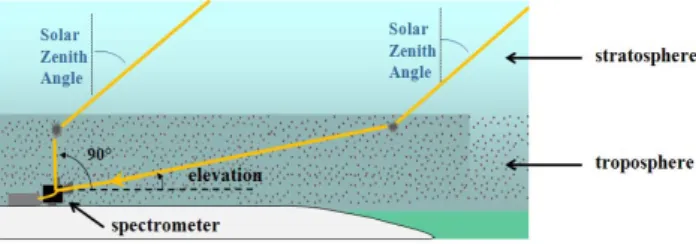
illustrated in Fig. 1 (H¨onninger and Platt, 2002; H¨onninger et al., 2004; Wittrock et al., 2004). Because the path to the last scattering point is confined to lower altitudes at eleva-tions close to the horizon, measurements at several elevaeleva-tions down almost to the horizon yield information about the verti-cal profile of the absorber within the troposphere. The
num-ber of MAX-DOAS instruments for NO2 deployed
world-wide has grown considerably in recent years. This increas-ing use of MAX-DOAS instruments for tropospheric obser-vations, together with the diversity of their designs and oper-ation protocols, created the need for a formal intercompari-son to include as many different instruments as possible.
The Cabauw Intercomparison Campaign of Nitrogen Dioxide measuring Instruments (CINDI) described here was held under the auspices of the European Space Agency (ESA), of the International Network for Detection of At-mospheric Composition Change (NDACC), and of the EU Framework 6’s ACCENT-AT2 Network of Excellence and GEOMON Integrated Project. ESA promotes accuracy of ground-based measurements that can be used for satellite val-idation; NDACC promotes excellence in measurements of at-mospheric composition; and GEOMON has been responsible for maintaining and developing networks of ground-based remote sensors, in support of the preparation of the GMES Atmospheric Service.
One component of ensuring high quality of measurements is to compare instruments and analyses when measuring and analysing identical felds, and NDACC holds intercompar-isons of relevant instruments and analysis techniques from
time to time. So far for NO2, only stratospheric
measure-ments have been intercompared (Lauder, New Zealand, in 1992 by Hofmann et al., 1995; Camborne, UK, in 1994 by Vaughan et al., 1997; OHP, France, in 1996 by Roscoe et al., 1999; and Andoya, Norway, in 2003 by Vandaele et al., 2005). Here we present results from the first intercomparison of MAX-DOAS as well as zenith-sky ground-based remote sensors of NO2.
19
Fig. 1. The principle of MAX-DOAS measurements (Multiple Axis, i.e. elevation scanning, with DOAS spectral analysis): the stratospheric paths at low elevation and zenith are almost identical at low solar zenith angles. Hence if a spectrum at lower elevation is divided by a zenith sky spectrum, the result of the subsequent spectral analysis is only sensitive to the tropospheric absorber amount.
Fig. 1. The principle of MAX-DOAS measurements (Multiple Axis, i.e. elevation scanning, with DOAS spectral analysis): the stratospheric paths at low elevation and zenith are almost identical at low solar zenith angles. Hence if a spectrum at lower elevation is divided by a zenith sky spectrum, the result of the subsequent spec-tral analysis is only sensitive to the tropospheric absorber amount.
The interest of ESA is stimulated by the ability of recent atmospheric chemistry nadir sensors such as GOME,
SCIA-MACHY, OMI and GOME-2 to measure tropospheric NO2.
More such instruments are planned, for example the GMES Sentinel 4 and 5 missions, and the GMES Sentinel 5 Precur-sor (to be launched in 2014). Validation of tropospheric com-position measurements from space is crucial because of the typically large uncertainties in retrievals that rely on a-priori knowledge of surface properties, cloud and aerosol effects and the vertical distribution of the measured trace gas.
Fur-thermore, tropospheric NO2 measurements from nadir
UV-visible sensors show little or no vertical discrimination be-yond correction for the stratospheric contribution, and are therefore limited to total tropospheric amounts. Hence sur-face in-situ measurements are not necessarily useful for val-idation, instead validation demands a technique that can de-liver the mean concentration throughout the troposphere, for which the elevation scanning of MAX-DOAS measurements is ideal.
In fact, elevation scanning allows two to three pieces of in-dependent vertical information to be retrieved, a subject that will be explored in a companion paper that will intercompare vertical profiles, retrieved using different inversion programs and/or different data sets. An important aspect of the retrieval is that the weighting functions are strongly dependent on the aerosol profile, which can be determined from measurements
of the oxygen dimer O4, which has a well known vertical
pro-file and several prominent absorption bands in the UV and
visible. However this introduces the need for accurate O4
measurements, hence they are included in this intercompari-son exercise.
Measurements in the UV part of the spectrum of NO2are
not particularly useful for measurements in the stratosphere as the absorption cross-section is smaller and the light in-tensity lower in the UV, leading to overall reduced sensitiv-ity. However, for tropospheric MAX-DOAS observations the situation is different as UV measurements have a different set of vertical weighting functions and a very different sen-sitivity to aerosol. Measurements in both visible and UV regions therefore improve the vertical information content
20
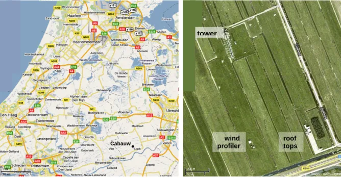
Fig. 2. Left: the site at Cabauw is located near Lopik in The Netherlands, 20 km SW of Utrecht. Right: the site has a tower, space for several containers with accessible roof tops, and another secure location at the wind profiler site.
Cabauw • tower wind profiler roof tops
Fig. 2. Left: the site at Cabauw is located near Lopik in The Netherlands, 20 km SW of Utrecht. Right: the site has a tower, space for several containers with accessible roof tops, and another secure location at the wind profiler site.
of MAX-DOAS measurements, as well as supplying redun-dancy for quality control. In other situations where only one MAX-DOAS instrument can be operated, the UV is some-times chosen because other important tropospheric gases can only be measured there (e.g. BrO, HCHO). Hence we also
include UV measurements of NO2and O4in this
intercom-parison.
Compared to earlier intercomparison campaigns dealing with stratospheric observations of the zenith sky at twilight,
measurements of tropospheric NO2 by MAX-DOAS face
different challenges:
1. Clouds interfere strongly with observations close to the horizon. They change the observed intensity, and they change the average light path and so the expected slant column. They also change the signal from interfering gases.
2. The expected temporal and spatial variability of
tropo-spheric NO2is large, which calls for a high
measure-ment repetition rate or exact synchronisation of mea-surements.
3. The need for good temporal resolution, together with the need for observation at different elevation angles, reduces the time available for individual measurements, which tends to reduce signal to noise ratios. On the other hand, measurements are taken during full daylight rather than twilight, which tends to increase signal to noise ratios.
4. The large change in sensitivity with elevation angle re-sults in a strict requirement for pointing accuracy, unlike
measurements of the zenith sky where pointing accu-racy is not an issue.
5. To ensure good agreement between measurements from different instruments, in spite of the horizontal
variabil-ity of NO2, good alignment in the viewing azimuth is
also needed.
2 The intercomparison campaign
The campaign took place at Cabauw (latitude 51.97◦N,
lon-gitude 4.93◦E, at sea level) at KNMI’s Cabauw
Experimen-tal Site for Atmospheric Research (CESAR), in The Nether-lands (see Fig. 2). This location was chosen because of its unobstructed views close to horizontal at many azimuth
an-gles, its large variability in tropospheric NO2, the absence
of local pollution sources, good local support because of its closeness to KNMI headquarters in De Bilt near Utrecht, and its tower of height over 200 m. The same site has been used for two previous MAX-DOAS campaigns focusing on validation of satellite observations (Brinksma et al., 2008; Hains et al., 2010).
The Cabauw site has a large suite of meteorological in-struments deployed continuously, specialising in the bound-ary layer. The tower has wind, pressure and temperature
in-struments at various heights, NO2is sampled in situ close to
the base of the tower, the wind profiling radar at its own site determines winds throughout the troposphere, and there is a cloud lidar at the site of the roof-top deployments. The site
1632 H. K. Roscoe et al.: Intercomparison of slant column measurements of NO2and O4
21
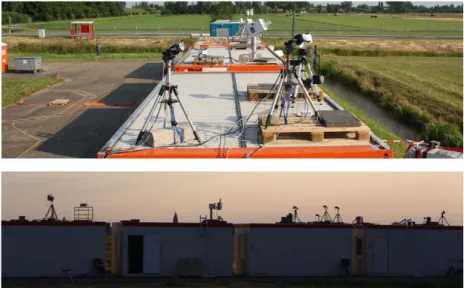
Fig. 3. Some of the roof-top instruments deployed at the campaign site, in views looking to the south (upper) and to the west (lower). Some other instruments were on the ground to the west of these containers; four other instruments were on the tower 370 m to the right of the lower picture; and a further three instruments were at the wind profiler site 160 m to the right of the upper picture.
Fig. 3. Some of the roof-top instruments deployed at the campaign site, in views looking to the south (upper) and to the west (lower). Some other instruments were on the ground to the west of these containers; four other instruments were on the tower 370 m to the right of the lower picture; and a further three instruments were at the wind profiler site 160 m to the right of the upper picture.
has a Total Sky Imager and a CT75 Ceilometer, and is a cer-tified BSRN irradiance measurement station and a cercer-tified AERONET aerosol measurement station. Some additional
instruments were assembled for the campaign – an NO2lidar
with elevation scanning and an aerosol lidar were deployed at
the roof-top site, extra in-situ NO2instruments were operated
on the ground and near the top of the tower, and some novel
NO2sondes were flown on balloons. Results from these
pro-filing instruments will be compared to retrieved profiles from the MAX-DOAS measurements in a companion paper.
The intercomparison campaign took place in June and July 2009. Instruments (see Fig. 3) were installed and tested between 8 and 14 June; the formal semi-blind intercom-parison was from 15 to 30 June inclusive (16 days); extra measurements of various kinds were continued by some in-struments until 24 July. During the formal intercomparison, most of the instruments were measuring most of the time, the maximum data absent from any one instrument being 4 days. Weather conditions were mixed, with frequent changes in cloud cover, some rainy periods, and some early-morning mist. There were five days with exceptionally clear skies throughout the morning: 18, 23, 24, 25 and 30 June. Spe-cial attention will be paid to their results because we might expect less scatter then, due to the absence of clouds passing overhead; and because they will be the important data sets for use in companion papers exploring profiling methods.
The instruments participating in the campaign not only dif-fer in design, but also in the way they are normally operated. Some scan from the horizon at close intervals in elevation, others take measurements at a smaller number of elevations. Some instruments also vary the azimuth angle, to investi-gate horizontal variability and to better constrain the aerosol
profiles. Some instruments are also capable of direct sun ob-servations. To ensure comparability of the measurements, a set of minimum requirements was defined which had to be performed by all instruments. This included measurements at elevations of 2◦, 4◦, 8◦, 15◦, 30◦and the zenith, all to be per-formed within a maximum of half an hour. All instruments
were oriented to an azimuth of 287◦(north-west). For the
in-tercomparison, only measurements with Solar Zenith Angle
(SZA) less than 80◦were used. Some instruments performed
measurements at additional elevation and/or azimuth angles, but these were not part of the formal intercomparison.
Following the precedent set by Roscoe et al. (1999) and adopted by Vandaele et al. (2005), the intercomparison pro-tocol was semi-blind:
a. Measurement and analysis results from the previous day had to be provided to the referee (HKR) by 10 a.m. At the daily meeting in the early afternoon, slant columns measured the previous day were displayed without as-signment to the different instruments.
b. The referee notifed instrument representatives if there was an obvious error so that it could be corrected im-mediately.
c. At the end of the formal campaign, plots had instrument names attached, and plots of mean differences from one instrument were discussed.
d. After the end of the formal campaign time, revisions were only accepted where full details of the reasons for changes were supplied.
Item b. was critical for instrument investigators because it avoided their wasting the majority of the campaign because
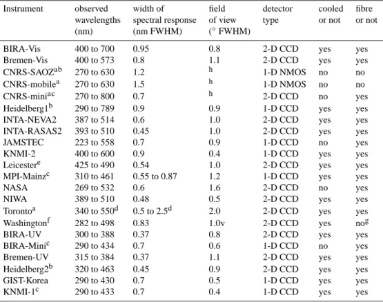
Table 1. Characteristics of the various spectrometers taking part in the intercomparison campaign. Locations were at the roof tops shown in Fig. 3 unless otherwise specified.
Instrument observed width of field detector cooled fibre wavelengths spectral response of view type or not or not (nm) (nm FWHM) (◦FWHM)
BIRA-Vis 400 to 700 0.95 0.8 2-D CCD yes yes Bremen-Vis 400 to 573 0.8 1.1 2-D CCD yes yes CNRS-SAOZab 270 to 630 1.2 h 1-D NMOS no no CNRS-mobilea 270 to 630 1.5 h 1-D NMOS no no CNRS-miniac 270 to 800 0.7 h 2-D CCD no yes Heidelberg1b 290 to 789 0.9 0.9 1-D CCD yes yes INTA-NEVA2 387 to 514 0.6 1.0 2-D CCD yes yes INTA-RASAS2 393 to 510 0.45 1.0 2-D CCD yes yes JAMSTEC 223 to 558 0.7 0.9 1-D CCD no yes KNMI-2 400 to 600 0.9 0.4 1-D CCD yes yes Leicestere 425 to 490 0.54 1.0 2-D CCD yes yes MPI-Mainzc 310 to 461 0.55 to 0.87 1.2 1-D CCD yes yes NASA 269 to 532 0.6 1.6 2-D CCD no yes NIWA 389 to 510 0.48 0.5 2-D CCD yes yes Torontoa 340 to 550d 0.5 to 2.5d 2.0 2-D CCD yes yes Washingtonf 282 to 498 0.83 1.0v 2-D CCD yes nog BIRA-UV 300 to 388 0.37 0.8 2-D CCD yes yes BIRA-Minic 290 to 434 0.7 0.6 1-D CCD no yes Bremen-UV 315 to 384 0.37 1.1 2-D CCD yes yes Heidelberg2b 320 to 463 0.45 0.9 2-D CCD yes yes GIST-Korea 290 to 430 0.7 0.5 1-D CCD yes yes KNMI-1c 290 to 433 0.7 0.4 1-D CCD yes yes
azenith only,bat the wind profiler site,cmounted on the tower,dchanged on 30 June to 315 to 380 nm and 0.2 to 0.8 nm, for MAX-DOAS measurements in the UV,ea joint
product with Leeds, who supplied the telescope and important on-site assistance,fWashington State University (WSU),gno fibre, but using a wedge depolariser, v in the vertical direction, less in the horizontal,hFOV not relevant as zenith sky only.
of an easily corrected error. For example, after the second day it was clear that at least one instrument had elevation
angles that were wrong by about 1◦ (see below). Without
correction, this would have been particularly frustrating as
the elevation sampling was at 2◦intervals, so that
measure-ments at the adjacent nominal elevation could not simply be substituted.
For instruments observing sunlight, it is important to di-vide the measurement spectrum by a reference spectrum, in order to eliminate fine structure in the solar spectrum (Fraun-hofer lines). The result of the subsequent spectral fit is then the difference in slant amounts of absorber between the mea-surement and reference spectrum. This quantity, sometimes called the “Differential Slant Column Density”, is what we hereafter call simply the “slant column”. For MAX-DOAS
measurements focussing on tropospheric NO2, the best
ap-proach is to divide by a reference spectrum containing the
same amount of stratospheric NO2, which would be the
zenith measurement during each elevation scan. Unfortu-nately the scans by instruments in this campaign could not be synchronised to each other, so the resulting slant amounts be-ing observed with such a choice of reference could be differ-ent for each instrumdiffer-ent, because of the temporal variability
in tropospheric NO2. We therefore chose to use as a
refer-ence the spectrum at zenith near local noon. Instrument sci-entists were encouraged to allocate at least half an hour for measurement of reference spectra, so that a spectrum could be selected without broken cloud passing the field of view,
important because cloud significantly alters the O4and
tro-pospheric NO2amounts.
3 Instruments
In total, 22 instruments from 14 institutes participated in the campaign. Table 1 shows that instruments observed over a
variety of differing wavelength ranges. However NO2 and
O4 were mostly analysed over a wavelength interval from
425 to 490 nm in the visible, or from 338 to 370 nm in the UV. Exceptions were MPI-Mainz that in the visible could only analyse from 420 to 450 nm, which also meant that it
could not provide a useful visible-O4value.
Most instruments had a field of view (Table 1) that would not permit seeing the horizon even at the lowest elevation
angle of 2◦, except in case of significant elevation errors
(see below). That of Toronto at 2◦ was much the largest:
1634 H. K. Roscoe et al.: Intercomparison of slant column measurements of NO2and O4
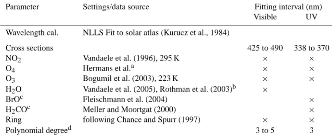
Table 2. Settings used for the analysis of spectra to produce slant columns of absorber. NLLS = non-linear least squares. Parameter Settings/data source Fitting interval (nm)
Visible UV Wavelength cal. NLLS Fit to solar atlas (Kurucz et al., 1984)
Cross sections 425 to 490 338 to 370 NO2 Vandaele et al. (1996), 295 K × ×
O4 Hermans et al.a × ×
O3 Bogumil et al. (2003), 223 K × ×
H2O Vandaele et al. (2005), Rothman et al. (2003)b ×
BrOc Fleischmann et al. (2004) ×
H2COc Meller and Moortgat (2000) ×
Ring following Chance and Spurr (1997) × ×
Polynomial degreed 3 to 5 3
ahttp://spectrolab.aeronomie.be/o2.htm,bbut using HITRAN 2004, cnot all instruments analysed with BrO and H
2CO in the UV,dexcept SAOZ, which does not use a polynomial fit.
22
Fig. 4. Comparison of raw and 30-minute averaged slant columns of NO2 measured by Bremen and
BIRA, on 19 June 2009 at elevation 15°. These are weighted averages, using as a weight the inverse square of the error of each data point given by its spectral fit. Measurements by BIRA are missing near local noon because BIRA investigators chose a longer period of measurements at 90° elevation in order to increase the chances of a cloud-free reference spectrum for the day.
Fig. 4. Comparison of raw and 30-min averaged slant columns of NO2measured by Bremen and BIRA, on 19 June 2009 at elevation
15◦. These are weighted averages, using as a weight the inverse square of the error of each data point given by its spectral fit. Mea-surements by BIRA are missing near local noon because BIRA in-vestigators chose a longer period of measurements at 90◦elevation in order to increase the chances of a cloud-free reference spectrum for the day.
it was designed as a zenith sky instrument, and only modi-fied to MAX-DOAS elevation scanning in the run-up to the campaign.
A uniform set of cross sections and other parameters was used for spectral analysis, as listed in Table 2. Cross sec-tions were all at room temperature except ozone. This is jus-tified by the dominance of tropospheric absorption features in lower-elevation spectra when using a zenith-sky measure-ment as the reference spectrum. We note that for quantitative analysis at large SZA, either corrections would be needed to
account for the low temperature at which stratospheric NO2
absorbs, or a reference from the same SZA must be used rather than noon.
Accuracy of the elevation of MAX-DOAS instruments can be a severe problem, as air mass factors change considerably with small changes in elevation when within one or two de-grees of the horizon. Most groups aligned their instrument via an external reference surface set to horizontal using a
spirit level (most spirit levels are accurate to 0.02◦ or
bet-ter). In many cases this was during an operating point in the elevation scan, which was then adjusted via software.
Unfortunately several instruments had significant backlash in the scanning mechanism, which became clear by the third
day of the campaign when 2◦-elevation values differed
sig-nificantly from other instruments whereas 8◦ agreed well.
For most instruments, a dark horizon of trees was visible,
whose non-zero elevation could be calculated within 0.05◦
from visual observation and dead reckoning. On a day with bright cloud, the dark horizon could be scanned to determine its apparent elevation, thereby finding the error in elevation
angle. Some instruments were as much as 1◦in error in their
earlier setting of horizontal.
4 MAX-DOAS results
Intercomparison of raw MAX-DOAS results between one in-strument and another proved difficult because the measure-ments were not simultaneous, and because measuremeasure-ments at low elevations were often changing rapidly in response to
variations in cloud and in NO2concentration. Figure 4 shows
an example, where a cloud at 15:20 UT caused a large
in-crease in slant NO2, but the difference in sample times
be-tween BIRA and Bremen measurements resulted in a large difference in the apparent increase. The difference was re-duced, though not in this case eliminated, by taking 30 min averages.
23
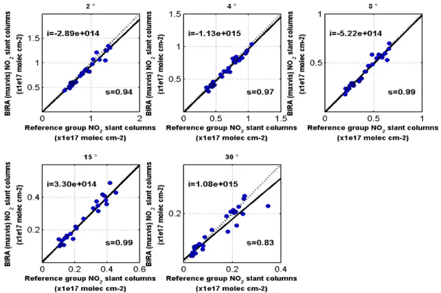
Fig. 5. Straight-line fits of 30-minute averages of slant columns of NO
2measured at each elevation
except 90°, by BIRA-Vis on 19 June 2009, against the averages of the reference group. Intercept
and slope values of the fitted lines (solid) are written on the plots. Dotted lines have unity slope and
zero intercept. The fits use the method of least squares, with weights of the inverse square of the
error of each 30-minute average (reference data are assumed to have no error). Similar fits using
data from all days were used to create the values in subsequent MAX-DOAS intercomparison
figures.
Fig. 5. Straight-line fits of 30-min averages of slant columns of NO2measured at each elevation except 90◦, by BIRA-Vis on 19 June 2009,
against the averages of the reference group. Intercept and slope values of the fitted lines (solid) are written on the plots. Dotted lines have unity slope and zero intercept. The fits use the method of least squares, with weights of the inverse square of the error of each 30-min average (reference data are assumed to have no error). Similar fits using data from all days were used to create the values in subsequent MAX-DOAS intercomparison figures.
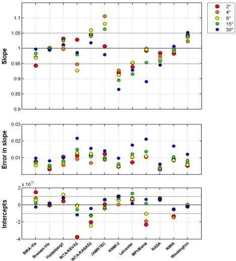
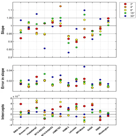
Taking 30-min averages also allowed us to use the mean of a set of instruments as a reference for the analyses, rather than just one instrument. An example analysis is shown in the straight-line fits in Fig. 5. The fits provide three types of information: the slope between the slant columns of each instrument and the reference, which should be close to 1; the intercept, which should be close to 0; and the scatter, which indicates the precision of the measurements, but also is in-fluenced by the sampling issues discussed above. Firstly we made plots for the instruments, such as Fig. 5, but against one instrument arbitrarily chosen as Bremen, in order to make a preliminary assessment of the quality of their slant columns. The most consistent instruments (those with similar slopes to each other, with small intercepts and with small residuals) were then chosen for the reference set for straight line fit-ting, and their weighted 30-min average values were found. Instruments in the visible reference set were Bremen-Vis, BIRA-Vis, INTA-RASAS2, NASA, NIWA and Washington. In order to facilitate comparison between all the instru-ments and all elevations, the slopes and standard errors in slope have been derived from fits similar to Fig. 5, using data from the whole time period of the formal intercomparison ex-cept those discarded because of elevation errors (see above). The results presented in Figs. 6 and 7 show that the means
of the fitted slopes for NO2and O4of all except one
instru-ment in the visible were within 10% of unity at almost all non-zenith elevations, and most were within 5%. The small values for the standard errors of the slopes show that these differences of slopes from unity are highly significant.
As mentioned above, adjustments were made to some in-struments and data sets early in the campaign, when the referee detected obvious inconsistencies in the values sub-mitted. In addition, revised values were used for Leicester, whose semi-blind results showed significant disagreement –
slopes smaller than 0.8 for NO2. The fault was analytical,
and arose from fitting errors introduced by custom spectral fitting software under development by this group. Following publication of slant column intercomparisons, spectra were reanalysed by the Leicester group using BIRA’s QDOAS software (a multi-platform derivative of WinDOAS), sig-nificantly improving agreement. Such algorithmic errors, which may remain undetected outside of an intercompari-son campaign, demonstrate the importance of the availability of trusted common retrieval software such as WinDOAS for validation of developmental algorithms, and the importance of checking developmental software when an instrument is deployed alone.
1636 H. K. Roscoe et al.: Intercomparison of slant column measurements of NO2and O4
24
Fig. 6. Straight-line slopes and their standard errors of NO2 slant columns against those of the
reference data set, for each instrument at visible wavelengths and for the whole campaign. Colours refer to elevation angles shown top right. Note that MPI-Mainz used a non-standard wavelength range for spectral analysis because of the limited range of the instrument (see Table 1).
Fig. 6. Straight-line slopes and their standard errors of NO2slant columns against those of the reference data set, for each instrument at
visible wavelengths and for the whole campaign. Colours refer to elevation angles shown top right. Note that MPI-Mainz used a non-standard wavelength range for spectral analysis because of the limited range of the instrument (see Table 1).
The question arises whether any of the differences in Fig. 6 are caused by interference from clouds. This seems unlikely given the small standard errors on the slopes. However, some part-days were almost entirely cloud free. These were espe-cially useful for comparison of vertical profiles, but they also enabled a definitive answer to this question. The part-days were the mornings of 18, 23, 24, 25 and 30 June, and Fig. 8 shows a similar plot to Fig. 6 but on just those part-days. It shows that the differences between instruments in Fig. 6 are not due to interference from clouds, as much of the pattern of differences is the same in the two figures. Figure 8 also shows that the scatter within any one instrument is not caused by the increase in variability expected from partial cloud – the results in Fig. 8 are if anything more scattered, which might be expected from a smaller number of days sampled if the variability were similar on all days.
It is also important to distinguish between good average agreement over the whole campaign with the reference data set, and the error bar for an individual day’s MAX-DOAS measurement as it would be used for satellite validation.
Table 3 lists the standard deviations of daily fitted slopes, which are a measure of this latter error. The values in Ta-ble 3 are more consistent with the larger scatter in Fig. 8 than in Fig. 6. Excluding the most extreme cases, the standard de-viations vary from 3 to 15%, with generally larger values at 30◦, probably due to the reduced slant columns at a larger el-evation. This day-to-day variability in the slopes results from the combined effects of instrumental noise and variability in pointing errors, together with the effect of the temporal mis-match between the measurements allied with the temporal
variability in the NO2concentrations. Because of elevation
errors and other instrument faults, some instruments had a smaller sample than others. However, only Heidelberg sam-pled less than half the available days at 2◦elevation, and half or more of the available days were sampled by all instruments at higher elevations (see Table 3).
Another way to assess the quality of measurements is to examine the histograms of differences from the reference data set. Ideally, the histograms should be symmetric and Gaussian in shape. Asymmetry might result from a number
25
Fig. 7. Straight-line slopes and their errors of O4 slant columns against those of the reference data
set, for each instrument at visible wavelengths and for the whole campaign. Colours refer to elevation angles shown top right. MPI-Mainz used a non-standard wavelength range for analysis, which did not produce an O4 amount.
Fig. 7. Straight-line slopes and their errors of O4 slant columns against those of the reference data set, for each instrument at visible
wavelengths and for the whole campaign. Colours refer to elevation angles shown top right. MPI-Mainz used a non-standard wavelength range for analysis, which did not produce an O4amount.
Table 3. Standard deviation of slopes of daily straight-line fits of visible MAX-DOAS NO2data to the visible reference data set, over the whole campaign, in units of % of 1.00, together with the number of days in the sample.
Elevation 2◦ 4◦ 8◦ 15◦ 30◦ days in sample 2◦el. >2◦el. BIRA-Vis 6.2 6.0 7.2 6.2 8.4 11 13 Bremen-Vis 2.8 2.8 6.5 7.0 6.6 16 16 Heidelberg1 5.6 5.6 6.9 5.4 5.6 6 16 INTA-NEVA2 8.7 8.1 10.2 8.5 13.4 9 9 INTA-RASAS2 2.8 2.5 16.1 8.2 5.4 9 12 JAMSTEC 6.5 6.9 9.8 8.5 9.7 8 14 KNMI-2 5.3 4.9 3.9 3.3 5.2 16 16 Leicester 5.5 4.9 6.8 12.9 19.6 15 15 MPI-Mainz 7.4 7.9 3.7 6.6 5.2 16 16 NASA 4.0 4.6 3.9 3.9 4.9 15 15 NIWA 4.0 3.4 5.1 5.2 14.2 9 11 Washington 2.8 6.5 6.3 6.7 6.0 10 12
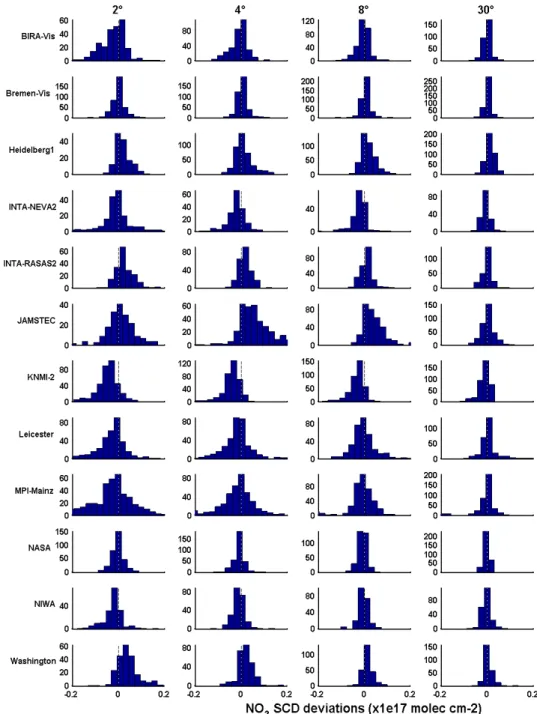
of reasons, for example saturation of some spectra, or attri-bution of absorption to the wrong cross-section at small ab-sorber amounts. Generally speaking, a large non-Gaussian tail to the distribution (especially if occurring at any ele-vation angle) implies poorer spectral fits in some circum-stances. Asymmetries or shifts occurring mostly at the low-est elevation angles might be related to pointing inaccuracies or variabilities. Figure 9 shows that Leicester, MPI-Mainz, JAMSTEC and INTA-NEVA had non-Gaussian tails to some of their distributions; and JAMSTEC, Heidelberg, KNMI-2, BIRA, Washington and NIWA had asymmetric distributions at certain elevations. However, the figure does show symmet-ric near-Gaussian histograms for many other combinations of instrument and elevation angle.
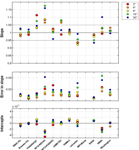
Eight of the instruments in the campaign had the ability to
measure NO2in the UV, where light intensities are smaller,
tropospheric light paths are shorter and sensitivity to aerosols is different. Figures 10 and 11 show that the means of the
fitted slopes for NO2 and O4 of all except one instrument
were within 12% of unity at almost all non-zenith eleva-tions, and most were within 7%. Again, the small values
1638 H. K. Roscoe et al.: Intercomparison of slant column measurements of NO2and O4
26
Fig. 8. Straight-line slopes and their errors of NO2 slant columns against those of the reference data
set, for each instrument at visible wavelengths, for clear sunny mornings only. Colours refer to elevation angles shown top right. Note the similarity to Fig. 6 in differences from unity slope for many instruments, but with larger scatter and errors because the number of data points is much smaller.
Fig. 8. Straight-line slopes and their errors of NO2slant columns against those of the reference data set, for each instrument at visible
wavelengths, for clear sunny mornings only. Colours refer to elevation angles shown top right. Note the similarity to Fig. 6 in differences from unity slope for many instruments, but with larger scatter and errors because the number of data points is much smaller.
for the standard errors of the slopes show that these differ-ences of slopes from unity are highly significant. In contrast to the results from the visible instruments, the size of errors is strongly linked to elevation, with the largest errors at 30◦, where signals are smallest. This indicates that in the UV, the error is probably dominated by the signal to noise ratio. The histograms (Fig. 12) show that most instruments have either asymmetric or non-Gaussian distributions of residuals at sev-eral elevations.
At the end of the formal intercomparison, Toronto mod-ified their zenith-sky instrument to include MAX-DOAS viewing, simultaneously moving to UV wavelengths so as to also measure HCHO. Several other instruments also con-tinued observations for some days, so a MAX-DOAS inter-comparison that includes Toronto could be made. The results in Fig. 13 show that Toronto performed well, with a slope within 8% of unity at all elevations and within 5% of unity at most elevations.
5 Zenith sky results near twilight
Although the focus of this intercomparison was on tro-pospheric observations, all instruments also performed
zenith-sky measurements during twilight, when sensitivity to stratospheric absorbers is largest.
However, in comparison to instruments operated solely for stratospheric measurements, the frequency of measurements was reduced, as a large fraction of the time was used for low-elevation measurements. Operation was changed to
zenith-sky only at about 80◦SZA, but this threshold varied slightly
between instruments, making the sampling of the time series highly variable.
Further, the technique used to compare MAX-DOAS mea-surements (straight-line fits to 30-min averages) cannot be used for zenith sky measurements because the slant amounts
of NO2change too rapidly during twilight. Hence we could
not provide an average of several instruments to use as a reference for straight-line fitting. Instead, we chose one in-strument with good sampling (INTA-RASAS2, see Fig. 14), and interpolated its values to the time of observation of each other instrument. Because INTA-RASAS2 was switched to UV observations later on 26 June, this limited the zenith-sky intercomparison to the period 15 June to 26 June.
If the fitted slopes of the style shown in Fig. 15 were used without modification, then most values would be less than unity because the values from INTA-RASAS2 were
27
Fig. 9. Histograms of the absolute deviations of visible measurements from the reference visible data set, for the whole campaign.
Fig. 9. Histograms of the absolute deviations of visible measurements from the reference visible data set, for the whole campaign.
generally a little larger than others. This would make it diffi-cult to make a sensible statement about the level of agree-ment. Instead, we found the average of the slopes of all instruments and divided all slopes by this average, to pro-duce the normalised values in Fig. 16 and Table 4. Figure 16 shows an excellent level of agreement – all instruments had slopes within 5% of the mean, thereby fulfilling the most
im-portant NDACC acceptance criterion for NO2 (see Roscoe
et al., 1999; Vandaele et al., 2005). Although this level of agreement is similar to what was achieved in the last cam-paign, this is a great success here, as this campaign had no
focus on twilight measurements, and Cabauw is not ideal for
a stratospheric NO2intercomparison because of the
signif-icant amounts of tropospheric NO2 on some days. As with
the MAX-DOAS intercomparisons, revised values were used for the Leicester instrument, whose semi-blind results had showed significant disagreement.
Another NDACC acceptance criterion is that the inter-cept should be less than or equal to ±0.1 × 10¹⁶molec cm−2. Table 4 shows that Heidelberg significantly exceeds the in-tercept limit, and Toronto and CNRS exceed it by small
amounts. The relatively large intercepts obtained in this
1640 H. K. Roscoe et al.: Intercomparison of slant column measurements of NO2and O4
28
Fig. 10. Straight-line slopes and their errors of NO2 slant columns against those of the reference
data set, for each instrument at UV wavelengths and for the whole campaign. Colours refer to elevation angles shown top right.
Fig. 10. Straight-line slopes and their errors of NO2slant columns against those of the reference data set, for each instrument at UV
wavelengths and for the whole campaign. Colours refer to elevation angles shown top right.
comparison (compared to previous exercises in clean sites like Lauder, OHP and Andoya) is to be expected. This is be-cause in such a polluted site, reference spectra that cannot be
perfectly synchronised will contain different amounts of NO2
because of its temporal variability in the troposphere. This is almost certainly the cause of the large intercept for Heildel-berg, with its otherwise good performance, arising for their instrument by chance.
The NDACC protocol also requests the measurement of slit function, polarisation and stray light. Measurement of slit function is requested via spectral lamps, but for this cam-paign most investigators used an analysis suite that deter-mined the slit function via fitting to Fraunhofer lines in the spectra themselves, which can allow for changes during the campaign. Polarisation is not an issue for the majority of the instruments that have a fibre between the input optics and the spectrometer – of those with no fibre, Washington uses a wedge polarizer and CNRS have instruments that have previ-ously been accepted because of their negligible polarization response. Finally, stray light is hardly an issue with modern spectrometers at the longer wavelengths analysed here.
Another NDACC requirement is to demonstrate the qual-ity of the data, e.g. by showing the smoothness of a time series. Here we have taken alternative approaches, investi-gating the distribution of differences from a reference instru-ment (Fig. 17), and the root-mean-square residuals from a straight line fit to the reference instrument (Table 4). Table 4 shows that most instruments except Leicester have similar residuals, and Fig. 17 shows that this is due to a few of their differences being atypically large, thereby biasing the rms. Discarding these outliers, Leicester’s histogram in Fig. 17 is similarly narrow to those of other instruments. Many his-tograms have some asymmetry, probably due to a depen-dence of the differences on SZA. For completeness, we also list in Table 4 the mean errors in the spectral fits, which are rather less than the residuals from the straight line fit, as might be expected.
To conclude, most instruments meet the zenith-sky crite-ria for endorsement by NDACC, with an important caveat about analysis software for Leicester (resolved by the use of the WinDOAS derivative QDOAS), and except for a strange distribution of differences from the Leicester instrument and
29
Fig. 11. Straight-line slopes and their errors of O4 slant columns against those of the reference data
set, for each instrument at UV wavelengths and for the whole campaign. Colours refer to elevation angles shown top right.
Fig. 11. Straight-line slopes and their errors of O4slant columns against those of the reference data set, for each instrument at UV wavelengths and for the whole campaign. Colours refer to elevation angles shown top right.
Table 4. Statistics of results from the intercomparison of zenith-sky measurements of slant columns of NO2at twilight. INTA-RASAS2 is
the reference, so its errors, intercepts and residuals have no meaning, and its slope is that of the mean of the whole group that defines the normalisation.
slope error intercept rms residuals error in spectral fit in slope (×1016molec cm−2) BIRA-Vis 1.030 0.003 0.012 0.282 0.062 Bremen-Vis 1.010 0.002 0.034 0.225 0.027 CNRS-SAOZ 0.955 0.002 0.114 0.348 0.134 Heidelberg1 1.015 0.003 0.231 0.358 0.091 INTA-NEVA2 0.989 0.002 0.086 0.247 0.029 INTA-RASAS2 1.043 – – – 0.044 Leicester 1.017 0.006 −0.052 0.964 0.039 NASA 0.973 0.003 0.062 0.298 ∗ NIWA 1.003 0.002 −0.049 0.250 0.108 Toronto 0.981 0.003 0.139 0.312 0.091 Washington 1.005 0.003 0.025 0.159 0.019
∗NASA used a custom spectral fit program that did not deliver a standard error in the slant amount.
1642 H. K. Roscoe et al.: Intercomparison of slant column measurements of NO2and O4
30
Fig. 12. Histograms of the absolute deviations of UV measurements from the reference UV data set, for the whole campaign.
Fig. 12. Histograms of the absolute deviations of UV measurements from the reference UV data set, for the whole campaign.
a large intercept for Heidelberg (that may be the result of a specific choice of reference spectrum on certain polluted days).
6 Conclusions
The level of agreement for zenith-sky measurements of NO2
– all instruments within 5% of the mean – equals that of previous intercomparisons despite the site not being ideal for zenith twilight measurements. Previous intercomparisons
were only for zenith instruments, hence they focussed on
stratospheric NO2. The fact that almost as good agreement
was found in MAX-DOAS measurements of NO2, which
have a much shorter heritage than zenith measurements, and that almost as good agreement was found for MAX-DOAS
measurements of O4, which are important to diagnose the
state of cloud and aerosol in the troposphere, bodes well for
the future of measurements of tropospheric NO2by this
31
Fig. 13. Straight-line slopes and their errors of NO2 slant columns against those of the reference
data set, for each instrument at UV wavelengths, for some days after the formal campaign so as to include Toronto in their new MAX-DOAS configuration. Colours refer to elevation angles shown top right. Some UV instruments are missing because they ceased operations after 30 June.
Fig. 13. Straight-line slopes and their errors of NO2slant columns against those of the reference data set, for each instrument at UV
wavelengths, for some days after the formal campaign so as to include Toronto in their new MAX-DOAS configuration. Colours refer to elevation angles shown top right. Some UV instruments are missing because they ceased operations after 30 June.
32
Fig. 14. Difference in solar zenith angle between adjacent measurements by a selection of instruments observing the zenith-sky on 22 June 2009 during evening twilight. The frequent and regular sampling by INTA made it ideal for selection as a reference for a straight-line fit to other instruments’ data. The jump in Toronto’s sampling interval at 87° SZA was caused by the instrument making one of its regular dark current measurements at that time.
Fig. 14. Difference in solar zenith angle between adjacent mea-surements by a selection of instruments observing the zenith-sky on 22 June 2009 during evening twilight. The frequent and regular sampling by INTA made it ideal for selection as a reference for a straight-line fit to other instruments’ data. The jump in Toronto’s sampling interval at 87◦SZA was caused by the instrument making one of its regular dark current measurements at that time.
While the agreement between the measurements from all the instruments is good, some points have been identified that are of particular relevance for MAX-DOAS observations:
1. Exact alignment of the elevation angle is of utmost im-portance, and probably should be checked on a regular basis (not relevant for instruments that include direct-sun capability, such as NASA, as alignment is then reg-ularly confirmed). During the campaign, problems with pointing were detected for several instruments which would have gone unnoticed in normal operations. 2. Temporal variability in the tropospheric signals is large,
and a high frequency of measurements is needed to ar-rive at representative results. For future intercomparison campaigns, synchronisation of measurements should be considered, as a significant part of the scatter is proba-bly due to differences in measurement time.
3. The consistency of NO2and O4observations is good but
not perfect, and their spread gives a useful indication of representative uncertainties to be assigned to these quantities when used in profile inversion.
1644 H. K. Roscoe et al.: Intercomparison of slant column measurements of NO2and O4
33
Fig. 15. Straight line fits of zenith sky measurements of NIWA and Toronto to those of INTA interpolated to the measurement time of NIWA and Toronto respectively. These are fits to twilight data from the whole campaign, hence the large density of measurements.
Fig. 15. Straight line fits of zenith sky measurements of NIWA and Toronto to those of INTA interpolated to the measurement time of NIWA and Toronto respectively. These are fits to twilight data from the whole campaign, hence the large density of measurements.
Fig. 16. Slopes, errors in slope, and intercepts, of straight line fits of each instrument’s data to that of INTA, for the whole campaign, after the slopes from fits such as those of Figure 15 were normalised by dividing by the mean of the slopes of all instruments.
Fig. 16. Slopes, errors in slope, and intercepts, of straight line fits of each instrument’s data to that of INTA, for the whole campaign, after the slopes from fits such as those of Fig. 15 were normalised by dividing by the mean of the slopes of all instruments.
35
Fig. 17. Histograms of the differences between zenith-sky results from each instrument and results interpolated from INTA-RASAS2. The histograms are for the whole campaign, and are normalised by the difference between the mean INTA-RASAS2 slope and the mean of all instruments. If both INTA-RASAS2 and the other instrument were of high standard, one would expect a narrow and symmetric histogram, though not necessarily symmetric about zero. The fact that several histograms are narrow and symmetric strongly suggests that they and INTA-RASAS2 are both of high standard.
Fig. 17. Histograms of the differences between zenith-sky results from each instrument and results interpolated from INTA-RASAS2. The histograms are for the whole campaign, and are normalised by the difference between the mean INTA-RASAS2 slope and the mean of all instruments. If both INTA-RASAS2 and the other instrument were of high standard, one would expect a narrow and symmetric histogram, though not necessarily symmetric about zero. The fact that several histograms are narrow and symmetric strongly suggests that they and INTA-RASAS2 are both of high standard.
Acknowledgements. We gratefully acknowledge the KNMI staff
at Cabauw for their excellent technical and infrastructure support during the campaign. The CINDI Campaign was for a large part funded by the ESA project CEOS Intercalibration of ground-based spectrometers and lidars (ESRIN contract 22202/09/I-EC) and the EU project ACCENT-AT2 (GOCE-CT-2004-505337). We further acknowledge the support of the EU via the GEOMON Integrated Project (contract FP6-2005-Global-4-036677). The participation of Roscoe is partly funded by the British Antarctic Survey’s Polar Science for Planet Earth programme, which is funded by the UK’s Natural Environment Research Council. The work of Cl´emer was supported by the Belgian Federal Science Policy Office through the AGACC project (contract SD/AT/01A and SD/AT/01B). The Bremen instruments are partly funded by the University of Bremen and the ENVIVAL-life project (50EE0839); their operation is sup-ported by GEOMON and MULTI-TASTE. The participation of the CNRS team was supported by the French Centre National d’Etudes Spatiales (CNES) and the instruments were funded by Institut des Sciences de l’Univers (INSU). University of Heidelberg were partly funded by the EU FP6 Project EUSAAR (2006-026140). The work of GIST was supported by a grant from the National Research Foundation of Korea (NRF) funded by the Korean government (MEST) (2010-0000773) through the Advanced Environmental Monitoring Research Center. The Heidelberg team were partly funded by the EU FP6 Project EUSAAR (2006-026140). JAM-STEC were supported by the Japan EOS Promotion Program of the Ministry of Education, Culture, Sports, Science and Technology
(MEXT), and by the Global Environment Research Fund (S-7) of the Japanese Ministry of the Environment. The work of Vlemmix and Piters is financed by the User Support Programme Space Research via the project “Atmospheric chemistry instrumentation to strengthen satellite validation of CESA” (EO-091). The work of Piters, Kroon, Hains, Boersma and du Piesanie is partly financed by the Netherlands Space Organisation via the SCIAVISIE and OMI Science projects. MPI were partly funded by EU Seventh Framework Programme FP/2007-2011 under grant 212520, and would like to thank Bastian J¨acker for logistical support. The participation of the Toronto team was supported by the Canadian Foundation for Climate and Atmospheric Science and the Centre for Global Change Science at the University of Toronto; the instrument was funded by the Natural Sciences and Engineering Research Council and the Canadian Foundation for Innovation, and is usually operated at the Polar Environment Atmospheric Research Laboratory (PEARL) by the Canadian Network for the Detection of Atmospheric Change (CANDAC). Washington State University acknowledges funding support from the National Aeronautics and Space Administration, grant NNX09AJ28G.
Edited by: R. Volkamer
1646 H. K. Roscoe et al.: Intercomparison of slant column measurements of NO2and O4
References
Bogumil, K., Orphal, J., Homann, T., Voigt, S., Spietz, P., Fleis-chmann, O. C., Vogel, A., Hartmann, M., Bovensmann, H., Frerik, J., and Burrows, J. P.: Measurements of molecular ab-sorption spectra with the SCIAMACHY Pre-Flight Model: In-strument characterization and reference spectra for atmospheric remote sensing in the 230–2380 nm region, J. Photochem. Pho-tobiol. A., 157, 167–184, 2003.
Brinksma, E. J., Pinardi, G., Volten, H., Braak, R., Richter, A., Schonhardt, A., van Roozendael, M., Fayt, C., Hermans, C., Dirksen, R. J., Vlemmix, T., Berkhout, A. J. C., Swart, D. P. J., Oetjen, H., Wittrock, F., Wagner, T., Ibrahim, O. W., de Leeuw, G., Moerman, M., Curier, R. L., Celarier, E. A., Cede, A., Knap, W. H., Veefkind, J. P., Eskes, H. J., Allaart, M., Rothe, R., Piters, A. J. M., and Levelt, P. F.: The 2005 and 2006 DANDELIONS NO2and Aerosol Intercomparison Campaigns, J. Geophys. Res.,
113, D16S46, doi:10.1029/2007JD008808, 2008.
Brewer, A. W., McElroy, C. T., and Kerr, J. B.: Nitrogen dioxide concentrations in the atmosphere, Nature, 246, 129–133, 1973. Chance, K. and Spurr, R. J. D.: Ring effect studies: Rayleigh
tering including molecular parameters for rotational Raman scat-tering, and the Fraunhofer spectrum, Appl. Opt., 36, 5224–5230, 1997.
Fleischmann, O. C., Hartmann, M., Burrows, J. P., and Orphal, J.: New ultraviolet absorption cross-sections of BrO at atmospheric temperatures measured by time-windowing Fourier transform spectroscopy, J. Photochem. Photobiol. A, 168, 117–132, 2004. Hains, J. C., Boersma, K. F., Kroon, M., Dirksen, R. J., Cohen,
R. C., Perring, A. E., Bucsela, E., Volten, H., Swart, D. P. J., Richter, A., Wittrock, F., Schoenhardt, A., Wagner, T., Ibrahim, O. W., Van Roozendael, M., Pinardi, G., Gleason, J. F., Veefkind, J. P., and Levelt, P.: Testing and improving OMI DOMINO tro-pospheric NO2using observations from the DANDELIONS and INTEX-B validation campaigns, J. Geophys. Res., 115, D05301, doi:10.1029/2009JD012399, 2010.
Hofmann, D. J., Bonasoni, P., De Maziere, M., Evangelisti, F., Giovanelli, G., Goldman, A., Goutail, F., Harder, J., Jakoubek, R., Johnston, P. V., Kerr, J. E., Matthews, W. A., McElroy, C. T., McKenzie, R. L., Mount, G., Platt, U., Pommereau, J-P., Sarkissian, A., Simon, P., Solomon, S., Stutz, J., Thomas, A., Van Roozendael, M., and Wu, E.: Intercomparison of UV/visible spectrometers for measurements of stratospheric NO2 for the network for the detection of stratospheric change, J. Geophys. Res., 100, 16765–16791, 1995.
H¨onninger, G. and U. Platt: The Role of BrO and its Vertical Dis-tribution during Surface Ozone Depletion at Alert, Atmos. Envi-ron., 36, 2481–2489, 2002.
H¨onninger, G., von Friedeburg, C., and Platt, U.: Multi axis dif-ferential optical absorption spectroscopy (MAX-DOAS), Atmos. Chem. Phys., 4, 231–254, doi:10.5194/acp-4-231-2004, 2004. Kurucz, R. L., Furenlid, I., Brault, J., and Testerman, L.: Solar flux
atlas from 296 nm to 1300 nm, National Solar Observatory Atlas No. 1, 1984.
Meller, R. and Moortgat, G. K.: Temperature dependence of the ab-sorption cross sections of formaldehyde between 223 and 323 K in the wavelength range 225–375 nm, J. Geophys. Res., 105, 7089–7101, 2000.
Noxon, J. F.: Nitrogen dioxide in the stratosphere and tropo-sphere measured by ground-based absorption spectroscopy, Sci-ence ,189, 547–549, 1975.
Platt, U. and Stutz, J.: Differential Optical Absorption Spec-troscopy, Principles and Applications, ISBN 978-3-540-21193-8 Springer, Berlin, 2008.
Platt, U., Perner, D., and Patz, H. W.: Simultaneous Measurement of Atmospheric CH2O, O3, and NO2by Differential Optical
Ab-sorption, J. Geophys. Res., 84, 6329–6335, 1979.
Roscoe, H. K., Johnston, P. V., Van Roozendael, M., Richter, A., Sarkissian, A., Roscoe, J., Preston, K. E., Lambert, J-C., Her-mans, C., DeCuyper, W., Dzienus, S., Winterrath, T., Burrows, J. P., Goutail, F., Pommereau, J-P., D’Almeida, E., Hottier, J., Coureul, C., Didier, R., Pundt, I., Bartlett, L. M., McElroy, C. T., Kerr, J. E., Elokhov, A., Giovanelli, G., Ravegnani, F., Pre-muda, M., Kostadinov, I., Erle, F., Wagner, T., Pfeilsticker, K., Kenntner, M., Marquard, L. C., Gil, M., Puentedura, O., Ar-lander, W., Kastad Hoiskar, B-A., Tellefsen, C. W., Heese, B., Jones, R. L., Aliwell, S. R., and Freshwater, R. A.: Slant column measurements of O3and NO2during the NDSC intercomparison
of zenith-sky UV-visible spectrometers in June 1996, J. Atmos. Chem., 32, 281–314, 1999.
Rothman, L. S., Barbe, A., Chris Benner, D., and Hitran-Team.: The HITRAN Molecular Spectroscopic Database: Edition of 2000 including updates through 2001, J. Quant. Spectrosc. Ra-diat. Transfer, 82, 5–44, 2003.
Vandaele, A. C., Hermans, C., Simon, P. C., Van Roozendael, M., Guilmot, J. M., Carleer, M., and Colin, R.: Fourier trans-form measurement of NO2absorption cross-section in the
visi-ble range at room temperature, J. Atmos. Chem., 25, 289–305, 1996.
Vandaele, A. C., Fayt, C., Hendrick, F., Hermans, C., Humbled, F., Van Roozendael, M., Gil, M., Navarro, M., Puentedura, O., Yela, M., Braathen, G., Stebel, K., Tørnkvist, K., Johnston, P., Kreher, K., Goutail, F., Mieville, A., Pommereau, J.-P., Khaikine, S., Richter, A., Oetjen, H., Wittrock, F., Bugarski, S., Friess, U., Pfeilsticker, K., Sinreich, R., Wagner, T., Corlett, G., and Leigh, R.: An intercomparison campaign of ground-based UV-visible measurements of NO2, BrO, and OClO slant columns: Methods
of analysis and results for NO2, J. Geophys. Res., 110, D08305,
doi:10.1029/2004JD005423, 2005.
Vaughan, G., Roscoe, H. K., Bartlett, L. M., O’Connor, F. M., Sarkissian, A., Van Roozendael, M., Lambert, J-C., Simon, P. C., Karlsen, K., Kastad, B. A., 0iskar, H., Fish, D. J., Jones, R. L., Freshwater, R. A., Pommereau, J.-P., Goutail, F., Andersen, S. B., Drew, D. G., Hughes, P. A., Moore, D., Mellqvist, J., Hegels, E., Klupfel, T., Erle, F., Pfeilsticker, K., and Platt, U.: An in-tercomparison of ground-based UV-visible sensors of ozone and NO2, J. Geophys. Res., 102, 1411–1422, 1997.
Wittrock, F., Oetjen, H., Richter, A., Fietkau, S., Medeke, T., Rozanov, A., and Burrows, J. P.: MAX-DOAS measurements of atmospheric trace gases in Ny- ˚Alesund – Radiative transfer studies and their application, Atmos. Chem. Phys., 4, 955–966, doi:10.5194/acp-4-955-2004, 2004.