HAL Id: hal-03239850
https://hal.archives-ouvertes.fr/hal-03239850
Submitted on 28 May 2021
HAL is a multi-disciplinary open access
archive for the deposit and dissemination of
sci-entific research documents, whether they are
pub-lished or not. The documents may come from
teaching and research institutions in France or
abroad, or from public or private research centers.
L’archive ouverte pluridisciplinaire HAL, est
destinée au dépôt et à la diffusion de documents
scientifiques de niveau recherche, publiés ou non,
émanant des établissements d’enseignement et de
recherche français ou étrangers, des laboratoires
publics ou privés.
Advances in fisheries science through emerging
observing technologies
Hassan Moustahfid, William Michaels, Brett Alger, Avijit Gangopadhyay,
Patrice Brehmer
To cite this version:
Hassan Moustahfid, William Michaels, Brett Alger, Avijit Gangopadhyay, Patrice Brehmer. Advances
in fisheries science through emerging observing technologies. Global Oceans 2020: Singapore - U.S.
Gulf Coast, IEEE / OES, Oct 2020, online, United States. �10.1109/ieeeconf38699.2020.9389452�.
�hal-03239850�
Advances in fisheries science through emerging
observing technologies
Hassan Moustahfid
National Oceanic and Atmospheric Administration,
U.S. Integrated Ocean Observing System, Silver Spring, MD,
United States of America
[email protected]
William Michaels
National Oceanic and Atmospheric Administration.
NOAA Fisheries, Silver Spring, MD,
United States of America
Brett Alger
National Oceanic and Atmospheric Administration.
NOAA Fisheries, Silver Spring, MD,
United States of America
Avijit Gangopadhyay
University of Massachusetts Dartmouth, New Bedford,
United States of America
Patrice Brehmer
IRD, Univ Brest, CNRS, Ifremer, IUEM-LEMAR,
Plouzané, France
U.S. Government work not protected by U.S. copyright
Global Oceans 2020: Singapore - U.S. Gulf Coast | 978-1-7281-5446-6/20/$31.00 ©2020 IEEE | DOI: 10.1109/IEEECONF38699.2020.9389452
Abstract.
Fisheries is in need for high-quality observations at scales that resolve critical ecological processes and are timely for management. Recent advances in ocean observing technologies have improved the spatial and temporal resolution of measurements, performed during conventional scientific surveys as collaborative approaches, to better understand the dynamics and organization of fish
populations and their associated habitat in a rapidly changing environment. In recent years, more reliable and cost-efficient sensors, platforms, and processing technologies have been deployed successfully, which we envision in the coming decade will revolutionize the wide-scale observations pertinent to ocean ecology and biology. The aim of this work is to review the emerging sensing technologies for selected major ecological and biological parameters relevant to fisheries science, and to identify transformative directions for future development of cost-effective technologies and deployment strategies.
Keywords: Fisheries, ecosystem, ocean observing
systems, sensor technology, Fisheries acoustic, electronic monitoring, genetic, optical, underwater unmanned systems, ship of opportunity, artificial intelligence, machine learning, partnership.
Introduction
Global fisheries are being exhausted in recent years, total global capture fisheries production in 2018 reached the highest level ever recorded at 96.4 million tonnes. This increase was mostly driven by marine capture fisheries, whose production increased to 84.4 million tonnes in 2018 (FAO, 2020). Based on recent FAO’s assessment (FAO, 2020), the fraction of fish stocks that are within biologically sustainable levels decreased from 90 percent in 1974 to 66 percent in 2017. In contrast, the percentage of stocks fished at biologically unsustainable levels increased, especially in the late 1970s and 1980s, from 10 percent in 1974 to 34 percent in 2017.
Numerous strategies exist to restrain fishing to sustainable limits, even for data-limited fisheries. Examples include: regulating the amount of catch (e.g., catch limits); limiting fishing effort (e.g., temporal/spatial restrictions, and marine protected areas (e.g., no fishing zones) etc. However, each of these approaches requires a gauge, or measure, of what level of fishing can be sustained year to year. And for this, accurate and timely scientific information is key. In US, after decades of overfishing had decimated many fish populations, Congress voted in 2006 to
require science-based annual catch limits for all federally managed species. These catch limits have contributed to improving sustainable fisheries in US. More than two-thirds of fish stocks with rebuilding plans have recovered or shown major improvement (Sewell, 2013). Yet many important species remain vulnerable because scientists don’t have enough data to set accurate catch limits. There is need for high-quality observations at scales that resolve critical ecological processes and are timely for management needs (Szuwalski & Hollowed, 2016). Recent technological advances have improved the spatial and temporal resolution of measurements, performed during conventional scientific surveys to better understand the dynamics and organization of fish populations and their associated habitat in a rapidly changing environment (Moustahfid et al., 2012, 2016; Wang et al., 2019). More reliable and cost-efficient sensors, platforms, and processing technologies have been deployed successfully thanks to partnerships between government agencies, academic institutions and private sectors. The aim of this work is to review the emerging sensing technologies for selected major ecological and biological parameters relevant to fisheries science, and to identify transformative directions for future development of cost-effective technologies and deployment strategies.
Emerging science and technologies
Fisheries Acoustics Sensors: Assess fish stocks, direct
estimates of fish biomass and high spatial resolutions
Today, ¿sheries acoustics (Simmonds and MacLennan, 2005) is a central discipline for in situ observations of aquatic organisms extending from plankton to whales (Brehmer, 2006). There exists a wide range of acoustic sensors (including echosounders and sonars systems) that can deliver datasets of relevance to fisheries stock assessments, including ¿sh abundance and distribution. However, accuracy and reliability are paramount when making biological measurements with acoustic sensors. During the last few decades, the main advance is the advent of multibeam (e.g., Guillard et al., 2011) and wideband (Demer et al., 2017) acoustic systems, although calibration and data treatment are still challenging with existing protocols (e.g., Perrot et al., 2018). Rapid advances in the miniaturization of acoustic sensors (transducers) and the improvement of batteries and computers allow them to be mounted on various mobile platforms, such as gliders, Autonomous Underwater Vehicles (Moline et al., 2015) and buoys (Brehmer et al., 2019a), thus rendering this sensing technology cost-e ective both
in hardware and in deployment compared to traditional shipboard transducers. Another major development in cost-e ective acoustic sensing is the scienti¿c wide band echosounders (Demer et al., 2017) which use a wide band transceiver (WBT) to replace the general purpose transceiver (GPT) that is used for narrow-bandwidth echosounders, e.g., the WBT Miniature wideband transceiver (WBT Mini), wide-band autonomous transceiver (WBAT), and WBT Tube Subsea transceiver (WBT Tube) (Lavery et al., 2017) (Figure 1). Such systems are compact in size and energy e cient, making them useful as a portable echosounder or for installation on a wide range of platforms (e.g., Saildrone by Mordy et al., 2017, see below platforms section). This allows long-term deployments in challenging environments, such as in the arctic, using the Acoustic Zooplankton and Fish Pro¿ler (Ludvigsen et al., 2018). Multibeam systems such as long-range omni directional sonar (Figure 2) (Brehmer et al., 2006), multibeam sonar (Korneliussen et al., 2009), and multibeam echosounder (Trenkel et al., 2008) have become more reliable and cost-e cient per unit of data output. The next step in lowering the overall cost in this ¿eld is to capture habitat characteristics at the ¿ne scale simultaneously with marine organism detections, and applying data processing and analytics from several acoustic sensors. Future concepts for ¿ne scale studies (>20 m) have been presented by Gerlotto et al. (2011) by building and operating a high-frequency, three-dimensional sonar that will allow observation and analysis of ¿ne scale dynamics within marine organism aggregations.
Fig. 1. Acoustic WBT system mounted in different type of platforms: Courtesy of Jeff Condiotty (Kongsberg Underwater Technology, Inc).
Fig. 2. Various sounders and sonar deployments and an autonomies video acoustics buoy system (reproduce from Brehmer et al., 2019a). (a) Underwater view of the active acoustic devices used to monitor marine biomass around the drifting FADs. (b) Split-beam echosounder transducers of different frequencies; (c) Pole-mounted high resolution multibeam sonar coupled to an underwater video camera; and (d) Hull-mounted omnidirectional multibeam sonar. (e) Autonomous buoy prototype using wireless satellite system (iridium transmission), solar panel and a web of underwater cameras. (f) Example data from a trial conducted in a tuna farming cage, where tuna schools are distinguished against the circular net of 60 m diameter.
Animal Borne Telemetry Sensors: Near real-time
geospatial animal telemetry data integral to realistic
parameterization of spatially explicit population and fishery assessment models
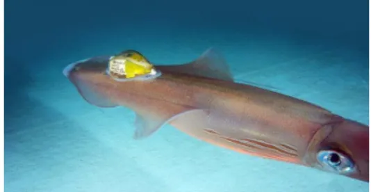
Animal Borne Telemetry Sensors (ABTS) have been used for decades to deliver physical oceanographic data and animal behavior observations at a relatively low cost (Hussey et al., 2015; Harcourt et al., 2019). ABTS are increasingly vital as we seek to observe changing oceans in greater temporal and spatial resolution as they o er a cost e ective strategy for autonomous sampling (Figure 3), with the sensor packages often on the scale of several hundred to a few thousand dollars per tag-package. The ability to a x tags to many animals means there are many tags concurrently making observations. While early ABTSs tended to record relatively basic information such as dive depth, duration, and temperature, innovative use of simple sensors, such as pressure to address ascent or descent rates and particular tracks, provides insight beyond behaviors such as foraging strategies, biological hotspots, occurrence rates (abundances), and relative densities of poorly understood (prey) layers (Arranz et al., 2011). New tag developments are striving to miniaturize sensors which would allow expanded use beyond the large vertebrates. These e orts include ABTSs carried by soft-bodied invertebrates such as jelly¿sh and squid (Mooney et al., 2015) (Figure 4). Many inertial motion sensors are widely available, thus driving down costs. Leveraging these and other “o -the shelf” sensors would help in further cost-reduction. 3D housing printing would reduce manufacturing costs. Additionally, improving data transfer, perhaps through microsatellites, would help cost-e ciency of gaining the observational data. Detailed observations of ABTS have significantly improved our understanding of ecosystem function and the evolutionary constraints of species. These data are critical for preserving biodiversity and parametrizing stock assessment models and implementing ecosystem-based approaches to Fisheries.
Figure 3. Underwater slocum glider equipped with acoustic receiver to study spawning activity of Atlantic Cod. (credit NOAA);
Figure 4. Squid with data-logging tag, called ITAG, attached to the dorsal surface of the squid rostrum, and positioned in line with the squid body to reduce drag (Mooney et al., 2015).
Optical Sensors: Monitoring the ecosystem
biodiversity and bio-productivity for fisheries
Among optical sensor, there is a wide variety of sensors starting from colorimetric sensor to holographic systems and obviously including classical pictures and video. This last one have been constrain by the analogical system which became digital since several decades and since have never stop to increase in resolution and quality. Nowadays it is possible to find in general consumer market dedicated systems deployed in surface or in the bottom using underwater digital camera for monitoring and inventories. Some of them are specialized in plankton observation like "Underwater Vision Plankton" UVP, ZooSCAN, FlowCAM (Picheral et al 2010; Wang et al., 2019) others for fish and macrofauna (Brehmer et al., 2019a). The high amount of digital picture and video in database which were too time consuming to be analyzed, can now be processed using Machine Learning. One of the highest innovations in the optical sensor family this last decade is the development of underwater holographic sensor systems (Hermand et al., 2014; Dyomin et al., 2020) (Figure 5) allowing to observe for the first time original dynamical under water scene at a millimeter accuracy, e.g., object size range 2 ȝm-200ȝm within a water volume of 1 mm × 1 mm × 2 mm. Underwater digital holographic sensor can solve the tasks of monitoring the ecosystem biodiversity and bio-productivity for fisheries.
Fig. 5. Holographic camera (intended to observe in situ plankton in 3D) implemented from the research vessel Thalassa during the AWA sea survey off Senegal. IRD-Ifremer / AWA 2014 campaign. Date of shooting: 07/17/2014; Country: SENEGAL; Copyright: © IRD-Ifremer / AWA Campaign - Olivier Dugornay.
Genetic Sensors: Scientifically-based decisions for
HAB impact on coastal fishery resources
Genetic sensors, also referred to as “Ecogenomic” Sensors (Wang et al. 2019), bring a wealth of analytical power to existing ocean monitoring instruments through in situ, autonomous detection and enumeration of speci¿c DNA or RNA sequences, providing information to improve detecting and monitoring of harmful algal blooms, toxins, pathogens, and invasive species to protect health and coastal economies (Scholin et al., 2018). The most advanced and only commercially available genomic sensor is the Environmental Sample Processor (2nd
Generation ESP; available through McLane Labs, Woods Hole, MA). The ESP has been demonstrated for monitoring ¿sh (using eDNA signatures), fecal indicator bacteria, other prokaryotes, invertebrates and harmful algae from the water column in real time (Scholin et al., 2018). As an example of the path to a miniaturized system, the third generation ESP is smaller and less complex than the second, now ¿tting in the nose of a long-range AUV capable of Lagrangian drift (Figure 6) (Pargett et al., 2015). Further reducing the size and complexity and improving the robustness of these instruments can signi¿cantly reduce operational costs associated with deployment and recovery (Wang et al., 2019). Genetic sensors and other omics techniques hold the promise to provide valuable information to evaluate target populations’ structure and distribution, generate indices of abundance, and support sustainable fisheries resources.
Fig. 6. (a) The third Generation ESP fits into the nose of a Glider- Photo courtesy of Bill Ussler (b) Long-Range Autonomous Underwater Vehicle; Ben Raanan), (c) Monitoring and Event Response for HAB Credit: NOAA
Electronic Monitoring Sensing Technology: Collect
timely and verified catch information to monitor fishing fleets improving fisheries management
Fishery managers and scientists are exploring how electronic monitoring (EM; global position systems (GPS), video cameras, and gear sensors) can improve the timeliness, quality, and cost effectiveness of fishery-dependent data collection and augment or replace onboard observers. However, one of the substantive barriers for broad scale implementation are the high costs of video review, transmission and storage. Currently, EM programs rely on labor intensive (and thus costly) processes, and there is a need to improve the timeliness of data management associated with new EM data streams. Computer vision (CV) applications that use machine learning (ML) based on annotated image-training datasets is a research area where tremendous technological advancement is currently occurring (Figure 7). CV and ML applications are also being used for underwater surveys (e.g., habitat, coral, fish) and aerial surveys (e.g., marine mammals), and there is a wide range of other applications. Much of the recent developments is derived from the speed and accuracy of newer deep learning models, which are well-suited for fisheries data because of their ability to perform detection, classification, clustering, and prediction. ML algorithms can be re-trained on any other image dataset for any other application providing a very cost effective transfer of technology especially where data collection techniques are similar.
a
b
c
There is interest is integrating CV and ML applications into fisheries-dependent data collection (Figure 8). By combining data collected from GPS, images, and other sensors, data processing could be substantially reduced and improve data timeliness for existing and future EM programs. However, it is important to take a calculated and collaborative approach to implement these technological advancements across Regions and guard against misguided and potentially wasteful efforts. This requires organized collection and annotation of data (i.e., training datasets) to use CV and ML applications widely, yet efficiently.
Fig. 7. Alaska longline vessel, captured by a mounted camera and applying CV to collect species and weight estimation. Photo credit NOAA Fisheries.
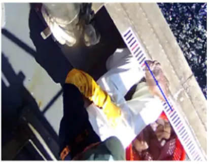
Fig. 8. New England groundfish trawl vessel, with crew processing discards on a measuring strip and using CV to collect species and length
information. Photo credit CVision AI.
Unmanned Systems: Filling the information gap and
supporting fisheries management
A combination of scientific, economic, technological and policy drivers is behind a recent rapid expansion in the use of unmanned airborne and marine systems (UxS) (and accompanying miniaturized sensors) for fisheries and environmental science. UxS are sensor-equipped vehicles that operate autonomously or are
remotely piloted. UxS has brought a corresponding increase in their innovative use as a force multiplier for increased spatial–temporal resolution and filling information data gap, at reduced cost, is particularly vital for effective fisheries management and collecting data in remote or extreme environments. In Alaska for example, scientists are deploying autonomous surface vehicles (e.g. Saildrone) (Figure 9) equipped with low-power sonar instruments or echosounder (see acoustic sensors section) to collect critically needed data to support management of the US largest commercial fishery for Alaska pollock. These ocean-going robots can cover roughly the same area normally covered by standard research vessels to estimate pollock abundance. These platforms are also equipped with solar-powered instruments to measure oceanographic and meteorological conditions (e.g. wind, solar radiation, surface temperature, and salinity measurements). The data can be transmitted to shore in real-time and made available to weather forecast centers worldwide via the World Meteorological Organization's Global Telecommunication System (GTS) so that the observations can be incorporated into weather predictions. UxS platforms have the potential to augment fishery surveys and advance ecosystem research and will provide some key scientific data at a time when it will be difficult to collect the data any other way.
Fig. 9. (a) Saildrone USVs (Photo courtesy Saildrone), (b) an example of Saildrone survey transects. The colors indicate the tracks of different Saildrones (c) Alaska Pollock aggregation measured from a Saildrone in the eastern Bering Sea. (Image credit: NOAA Fisheries).
Ship of Opportunity (Volunteer Opportunity Ships – VOS): collection of huge amount of data, and
automatic acquisition from commercial to fishing vessel
The last decade has seen a significant rise of the ship of opportunity (or Voluntary Opportunity Ships – VOS) (Kent et al., 2010), including fishing vessels which can almost continuously collect a great amount of observations data on a large spatial scale (Brehmer et al. 2006 ; Patti et al. 2016). Using VOS to collect environmental data dates back to 1853 Brussels Conference but became more established at the start of the 20th century. The first attempt was mainly centered
on physical data as temperature, salinity and meteorological data, starting from the use of eXpendable Bathy (Reverdin et al., 2009) to the deployment of more sensitive sensors as pCO2 (Steinhoff et al., 2019). In recent years with rapid changes and increasing use of citizen science, fishing vessels and fishing gears are becoming new VOS programs collecting observations data in support of oceanography and ¿sheries science and speci¿cally for addressing the challenges of rapid climate change and for strengthening the coastal fisheries and ocean observing system. Fishing vessels operate as VOS could foster ¿sheries research and oceanography at a much lower cost than those incurred from using dedicated oceanographic vessels (Figure. 10). With the observations being used ever more effectively, it is hoped that the coming decade will see more of these programs and networks to fill the data gaps. More recently such approach is now also tested on fishermen canoe (Brehmer et al., 2017) in developing countries.
Fig. 10. Commercial fishing gear can be a cost effective platform for collecting observations data (Courtesy Cooper Van Vranken (berringdatacollective.com).
Data processing and future directions: the time of
big data and artificial intelligence?
Two overarching issues for increasing the number of sensors and platforms are long-term power consumption and data transmission (Brehmer et al., 2019a; Wang et al., 2019). In remote deployments where telemetry to shore via Wi-Fi is unrealistic, non-sensor costs may outrun the savings in non-sensor hardware. Cost-e ective sensors thus need to consider strategic development of sensing nodes along with (i) networking and (ii) computational demands of models that use the sensor data (Wang et al., 2019). Future sensors could potentially locally process information to feed to an onboard target model. Onboard data fusion or feature extraction has already been carried out for detection of local threats (e.g., onset of harmful algal blooms). We can then identify promising pathways forward in underwater communication and networking (e.g., Song et al., 2019) and data fusion (already used for above-water radar applications like Guerriero et al., 2010). Other future directions include: (i) adaptability of Artificial Intelligence (AI) particularly Machine Learning (ML) technology to learn from recent changes (e.g., Gawarkiewicz et al., 2018; Gangopadhyay et al., 2019) and future projections of warming rates, and (ii) need for observing concurrent observations of meteorology, physics, chemistry, biology and seafloor by these sensors and using Big Data analysis to train those AI algorithms.
Partnerships a key to advancing fisheries sensing
technology
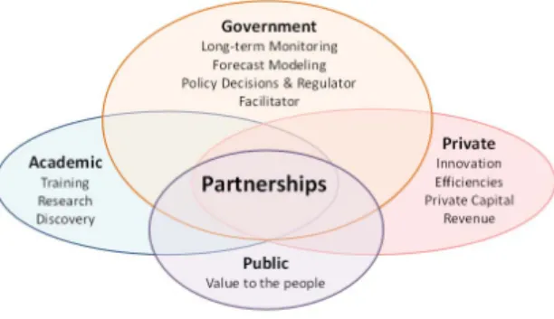
Public-private partnerships involving cooperative research and development among industry, government, and universities can play an instrumental role in introducing key new technologies to the market. Experience shows that partnerships involving government participation in cooperative research and development with industry, universities, and government laboratories can work (NRC, 2003). Properly constructed, operated, and evaluated partnerships can provide an effective means for accelerating the progress of technology from the Research and Development to the market (Figure 11) (Michaels et al., 2019). Successful partnerships tend to be characterized by industry initiation and leadership, public commitments that are limited and defined, clear objectives, cost sharing, and learning through sustained evaluations of measurable outcomes, as well as the application of the lessons to program operations.
Fig. 11. The value-based drivers for the academic, governmental, and private sectors that should be considered when developing partnerships (Michaels et al. 2019).
Conclusion
Further development and access to sensing observing technologies and the provision of near and real-time data could provide fisheries scientists with information that could enable safe increases in catch limits, catalyze fleet-wide innovations and could lead to cleaner fishing and vastly expand management options. A shift toward ocean observing technologies that are significantly lower in cost means new
high-resolution applications can be targeted. Fisheries
sentinel programs and networks based on voluntary opportunity ships and animal borne telemetry in general can provide critical data to support fisheries management in rapidly changing climate.
As we increase the use of emerging new technologies and the provision of big data, new approaches of processing and analysis based on AI and routine algorithms (in open source and free software) will be required to optimize observational assets and sampling strategies that could lead to better fisheries management options. Calibrations and inter calibrations are also critical requirements when working on e.g., time series, or augmenting and improving operations and data streams with technology advancements. Finally, partnership is a key to advancing sensing technology and achieving and maintaining sustainable fisheries.
Cited References
Arranz, P., et al. (2011). Following a foraging ¿sh-¿nder: diel habitat use of Blainville’s beaked whales
revealed by echolocation. PLoSOne6: e28353. doi:10.1371/journal. pone. 0028353
Bradley et al. (2019). Opportunities to improve fisheries management through innovative technology and advanced data systems. Fish Fish. 2019; 20: 564– 583.
Brehmer, P., et al. (2006), Omnidirectional multibeam sonar monitoring: applications in fisheries science. Fish and Fisheries, 7: 165-179. doi:10.1111/j.1467-2979.2006.00218.x
Brehmer, P., et al. (2019a), Towards an Autonomous Pelagic Observatory: Experiences from Monitoring Fish Communities around Drifting FADs. Thalassas 35, 177–189. doi: 10.1007/ s41208-018-0108-8 Brehmer P, et al. (2017). The interest of smartphone use for field Fisheries and marine environmental sciences surveys in West Africa : a demonstration project AWAphone. In : Proceedings of International conference ICAWA 2016. Dakar : Sub Regional Fisheries Commission; IRD, 54-55.
http://horizon.documentation.ird.fr/exl-doc/pleins_textes/divers18-01/010072115.pdf
Brehmer P., et al. (2019b). Vessel avoidance response : a complex tradeoff between fish multisensory integration and environmental variables. Reviews in Fisheries Science and Aquaculture, 27 (3), 380-391.
doi:10.1080/23308249.2019.1601157
Demer, D. A., et al. (2017). 2016 USA–Norway EK80 Workshop Report: Evaluation of a Wideband Echosounder for Fisheries and Marine Ecosystem Science. ICES Cooperative Research. Report 336. Copenhagen: International Council for the Exploration of the Sea, 69.
FAO. (2020). The State of World Fisheries and Aquaculture 2020. Sustainability in action. Rome. https://doi.org/10.4060/ca9229en
Gaillard F, et al. (2015). Sea surface temperature and salinity from French research vessels, 2001-2013. Scientific data, 2, 150054.
Gerlotto, F. P., et al., (2011). Development of real three-dimensional sonar for observing small scale dynamics of ¿sh inside a school. J. Acoust. Soc. Am. 129, 2697–2697.doi:10.1121/1.3589051
Goni, G., et al. (2010). “The ship of opportunity program,” in Proceedings of OceanObs'09: Sustained Ocean Observations and Information for Society, eds J. Hall, D. E. Harrison, and D. Stammer (Auckland: ESA Publications).
Guillard, J., et al. (2011). Three-dimensional internal spatial structure of young-of-the-year pelagic freshwater ¿sh provides evidence for the identi¿cation of ¿sh school species. Limnol. Oceanogr. Methods 9, 322–328. doi:10.4319/lom.2011.9.322
Harcourt, R. et al. (2019). Animal-borne telemetry: An integral component of the ocean observing toolkit.
Frontiers in Marine Science. Frontiers Media S.A. https://doi.org/10.3389/fmars.2019.00326
Hermand, J. P., et al. (2014). “Non-destructive optical holographic imaging of microorganisms in situ o the Senegalese coast,” in Proceedings of the OCEANS2014-TAIPEI, (Taipei),1–4.
Hussey, N. E., et al. (2015). Aquatic animal telemetry: a panoramic window into the underwater world. Science 348, 1221–1231. doi: 10.1126/science.1255642
Kent, E. et al. (2010). The Voluntary Observing Ship
(VOS) Scheme. 518-528. 10.5270/OceanObs09.cwp.48.
Korneliussen, R. J., et al. (2009). Combining multibeam-sonar and multifrequency echosounder data: examples of the analysis and imaging of large euphausiid schools.ICESJ.Mar.Sci.66,991–997. doi:10.1093/icesjms/fsp092
Lavery, A. C., et al. (2017). Exploiting signal processing approaches for broadband echosounders. ICES J. Mar. Sci.74, 2262–2275. doi:10.1093/icesjms/fsx155
Ludvigsen, M., et al. (2018). Use of an autonomous surface vehicle reveals small-scale diel vertical migrations of zooplankton and susceptibility to light pollution under lowsolarirradiance. Sci. Adv. 4:eaa9887. doi:10.1126/sciadv.aap9887
Michaels et al. (2019). Machine learning to improve marine science for the sustainability of living ocean resources: Report from the 2019 Norway - U.S. Workshop. NOAA Tech. Memo. NMFS-F/SPO-199, 99 p.
Moline, M. A., et al. (2015). Integration of scienti¿c echo sounders with an adaptable autonomous vehicle to extend our understanding of animals from the surface to the bathypelagic. J. Atmos. Ocean. Technol. 32, 2173–2186. doi: 10.1175/jtech-d-15-0 035.1 Mooney, T.A., et al. (2015). ITAG: an eco-sensor for ¿ne-scale behavioral measurements of soft-bodied marineinvertebrates. Anim. Biotelem. 3, 31–46. Mordy, C., et al. (2017). Advances in ecosystem research: Saildrone surveys of oceanography, ¿sh, and marine mammals in the Bering Sea. Oceanography 30, 113–115. doi:10.5670/oceanog.2017.230
Moustahfid, H., et al. (2012). Advancing Ecosystem Observing System: Fully Integrated Ocean Observing Systems Supporting Ecosystem-Based Management. MTS/IEEE Oceans 2012.
National Research Council. (2003). Government-Industry Partnerships for the Development of New Technologies. Washington, DC: The National Academies Press. https://doi.org/10.17226/10584. Pargett, D.M., et al. (2015). Development of a mobile ecogenomic sensor, in Proceedings of the
OCEANS’15 MTS/IEEE Washington, (Washington, DC: IEEE), 1–6
Patti, B., et al. (2016). The 684 Fishery and Oceanography Observing System (FOOS): a tool for oceanography and fisheries 685 science. J. Oper.
Oceanogr. 9, s99–s118. doi:10.1080/1755876X.2015.1120961.
Perrot, Y., et al. (2018). Matecho: an open-source tool for processing ¿sheries acoustics data. Aust. Acoust. 46, 241–248. doi:10.1007/s40857-018-0135-x Picheral, M., et al. (2010). The Underwater Vision Profiler 5: An advanced instrument for high spatial resolution studies of particle size spectra and zooplankton. Limnol Oceanogr-meth 8: 462-473. Reverdin, G. F., et al. (2009). XBT temperature errors during French research cruises (1999-2007). J. Atm. Oc. Tech.-Oceans, 26, 2462-2473, doi: 10.1175/2009JTECHO655.1.
Scholin, C. A., et al. (2018). The quest to develop ecogenomic sensors: a 25-Year history of the environmental sample processor (ESP) as a case study.
Oceanography 30, 100–113. doi:10.5670/oceanog.2017.427
Sewell B., et al. (2013) “Bringing Back the Fish,” Natural Resources Defense Council, February 2013, https://www.nrdc.org/sites/default/files/rebuilding-fisheriesreport.pdf
Simmonds, J., and MacLennan, D. N. (2005). Fisheries Acoustics: Theory and Practice, 2nd Edn.
Oxford: Wiley-Blackwell, 456.
Steinhoff T., et al. (2019). Constraining the Oceanic Uptake and Fluxes of Greenhouse Gases by Building an Ocean Network of Certified Stations: The Ocean Component of the Integrated Carbon Observation System, ICOS-Oceans, Front. Mar. Sci. 6:544, 2019. Doi: 10.3389/fmars.2019.00544
Suberg L., et al. (2014). Assessing the potential of autonomous submarine gliders for ecosystem monitoring across multiple trophic levels (plankton to cetaceans) and pollutants in shallow shelf seas, Methods in Oceanography, 10, 70-89, https://doi.org/10.1016/j.mio.2014.06.002.
Szuwalski, C. S., and Hollowed, A. B. (2016). Climate change and nonstationary population processes in fisheries management. ICES Journal of Marine Science, 73, 1297–1305.
Trenkel, V. M., et al. (2008). The new ¿sheries multibeam echosounder ME70 :description and expected contribution to ¿sheries research. ICESJ.Mar.Sci.65,645–655.
doi:10.1093/icesjms/fsn051
Wang, A. Z., et al. (2019). Advancing Observation of Ocean Biogeochemistry, Biology, and Ecosystems with Cost-effective In Situ Sensing Technologies.
Front. Mar. Sci., https://doi.org/10.3389/fmars.2019.00519