Print ISSN: 2357-0849
International Journal on:
Proceedings of Science and Technolgy
Re-appropriation of urban heritage buildings and their
role in the conservation of historic sites; case study:
casbah Belamech (Tindouf - Algeria)
Ibrahim ZEROUAL
1/ Djelloul ZENATI
21
Senior Lecturer, Head of Department C.U.T
2
Lecturer C.U.T, Phd Student, Researcher at LVRGT (USTHB)
zenatidjelloul@yahoo.fr
KeywordsIdentity, Sustainability
and Environment
(SIE), Heritage,
Casbah of Belamech
;Abstract
The importance of historical sites containing archaeological and
architectural fabrics has many physical, economic and social; they
differ depending on the form and structure in different areas of the
city. The historic environment of the urban content for historic
buildings and heritage guides the manager to the preservation of the
entities. Research shows that there is a large gap between the
classroom buildings and the development process of the surrounding
urban environment. By focusing on sustainable development of the
historical heritage areas, it is necessary to operate a reallocation of
buildings for better preservation. The study covers the following: the
attempt to link the new features for creating activities of the heritage
of the population of the surrounding environment, to increase the
degree of attention of the living environment around the building.
Factors that affect the process of maintenance, and reuse of heritage
buildings in the choice of assignment. It is proposed to try to find a
general concept for the development of heritage areas within the
public sphere. The role of community participation as a means of
awareness and the definition of ordinary citizens of the importance of
the environment and heritage content. It also discusses the mapping
methods to study and treat to represent the heritage buildings through
reallocation as one of the important conservation measures through
the example of the Casbah of Belamech. This research also presents a
set of conclusions and recommendations in the form of a model with
an information system on the environment (SIE) to develop the most
important features in the development of heritage buildings, to ensure
the sustainability of its environment.
1. INTRODUCTION
Face of architectural ensemble means, among others, knowing the complexity. Indeed, we must study and understand the geometric genesis from which spring shapes and volumes, analyzing the relationship between the various components, check the consistency of the material and its condition. Topography, essential basic tool for professionals (architects, engineers, archaeologists ...) is today, and the techniques and technologies it uses (think of the numerical methods, for example) booming. Today, the rising metric may not only be limited to measuring the architectural much discussed, but must become a complete and comprehensive document of its state, a scientifically correct testimony. That's why it should be based not only on numerical and graphical data, but also on historical elements and the use of archive documents: everything should contribute to help achieve a global vision and understanding "360 degrees ". Sunrise is well designed play a fundamental role irreplaceable instrument of knowledge; it can achieve a full and effective appropriation of space studied.
The importance of historical sites containing archaeological and architectural fabrics has more physical, economic and social characteristics that differ according to the form and structure of the different sectors of the city. This configuration also differs from one country to another and from one city to another and constitutes the historic environment of the urban content for historic buildings and heritage. The most important historical elements and preservation of the environment is one of the most important issues of heritage. Research shows that there is a large gap between the classroom buildings and the development process of the surrounding environment, while focusing attention on the sustainable development of historic heritage areas as part of an overall plan. The study of factors influencing the process of returning to employment and the extent of their impact on the suitable employment of built spaces, related to the environment, proposes to ensure the interaction of people with new uses.
Research in this area focuses on the following points:
- The attempt to link the new features for creating activities of the heritage of the population of the surrounding environment, to increase the level of living environment of care around the circular building. - The study of factors influencing the process of maintenance and reuse of heritage buildings in the choice of
the activity.
- The search for a general concept for the development of heritage areas within the public sphere.
- The role of community participation as a means of awareness and the ordinary citizen definition of environmental importance of heritage content.
The article also discusses the research study methods for the treatment of heritage buildings through reallocations as important measures of conservation and through the study of the Casbah Belamech. Of course, faced with a population that continues to urbanize, automatic 3D models of urban reconstruction is a challenge increasingly important for developers and restaurateurs. Different methods have been developed in an automated environment, mainly from, aerial and laser data, but this is insufficient to understand the urban space and its socio-economic issues. Aerial images are the type most frequently used data. Various techniques have been studied include using a structural approach [Fuchs et al., 00], a perceptual organization [Nevatia et al., 02], a multifaceted approach shots arrangement [Taillandier et al., 04] [Baillard et al ., 00], or even a parametric modeling [Weidner et al., 95]. The laser data are also used. Although the steps are very accurate, they generally have a low density of points on the vast acquisition areas such as cities. The view that geography is essentially a science of distribution is a theme that emphasized the strong dependence of geography with regard to concepts of geometry and topology. This recognition of concepts related to human geography location brings crucial for systematic science (heritage conservation, urban planning and urban development ...). The main alternative is then to propose methods based on strong prior knowledge of urban structures to compensate for the low-resolution data. Open systems have some of the following six characters:
1. Maintenance and conservation require a supply of energy, 2. Ability to reach a steady state with the form of adjustments, 3. Capacity homeostatic adjustments,
4. Conservation optimal system size,
5. Retention of the organization and form in time to avoid a maximum entropy, 6. The assurance of behavior “Equifinality”for identical results.
The use of templates is made necessary by the complexity of reality as they are a conceptual support to the test of reality. Currently, the development of these models may be requested by structuring schemes based on the method HBDS (Bouille 1997) or on conceptions entity / organization regarding the MERISE method. The mapping methods are used to separate components of a larger scale (regional) of lower level components (local level). The mapping of surfaces trend presents opportunities for urban planning and physical geography. The spatial distribution of the frame depending on the type us toward achieving a trend Plan valuing heritage and its possible preservation. The result of this research presents a set of conclusions and recommendations to develop important features in the allocation of heritage buildings and to ensure the sustainability of its environment.
GEOGRAPHICAL FRAMEWORK, HISTORICAL OVERVIEW & SITUATION
The city of Tindouf is located in the extreme western desert region of Saoura, south of Hamada Draa and North-western Erg Iguidi. Geographically it is located 800 km southwest of Bechar 770 km west of Adrar, 1475 km to the northwest of Tamanrasset and 1460 km southwest of the capital Algiers; it is also situated 50 km east of the border with Western Sahara and Morocco and 65 km north of the border with Mauritania. Geographic coordinates of the joint at the midpoint of its capital are respectively 27 ° 40 '00 "N 8 ° 09' 00" W.
The entire territory of the wilaya of Tindouf is now a natural park. The steps initiated in recent years by local authorities, the Tourism Directorate, culture and conservation of forests, for the attention of senior officials on the wide variety of attractions in the region and the need to protect, eventually resulted. Indeed, after consultation with the National Commission of Cultural Property at its meetings in 2005, the Executive Decree No. 08-159 of 28 May 2008, published in Official Gazette No. 28 of June 1 last, came in article first, stipulate the creation and delimitation of the natural park of Tindouf. And that, pursuant to the provisions of Law No. 98-04 of 15 June 1998 on the protection of cultural heritage, in particular in Article 39. The geographic coordinates of this park, which covers an area of 168,000 km2, are the administrative boundaries of the wilaya of Tindouf. The archaeological heritage of the town includes the rock carvings, giant tombs, tumulus and megaliths of Lakhal region, southeast of the town.
The entire territory of the town of Tindouf is included in the Natural Park of Tindouf dedicated to the preservation of sites and historical and cultural monuments, created in 2008 and covering the whole territory of the wilaya of Tindouf.
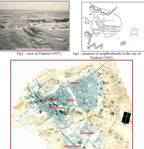
Fig1 : view of Tindouf (1957) fig2 : situation of neighborhoods in the city of Tindouf (1952)
Fig3 :current view of the city of Tindouf (google image), the extension of the city is oriented south / east and north / east and the population reached in 2010 50,000 inhabitants. A disorder is observed for the housing category. A gradual elimination is noticed at historic sites.
1.2. HISTORICAL OVERVIEW
According to the clipping plane to the Decree establishing it, the Tindouf Nature Park is bounded by two wilayas (Bechar northeast and southeast Adrar) and by the borders of the three neighboring countries (those to the north of Morocco west, Mauritania to the south and the Sahrawi Arab Democratic Republic to the southwest). This vast region of southwest Algeria, still little known - It has not been archaeological studies - offers control sites of ancient civilization.
For example, the region of Lakhal on the southern boundary of the province, holds alone twenty engravings stations, giant tombs, tumulus, megaliths. Moreover, pottery fragments from the Paleolithic period, footprints, fossils of animals and plants in the late 3rd geological age. Its classification as a nature reserve was required since it is a protected area against all kinds of violations of this rich heritage. On the other hand, the ksour reflect examples of different styles. The scraper Saharan world has a spatial distribution of commercial and not necessarily homogeneous cultural centers. In a chaos of ruins and clear stones, themes and wall decorations containing nails of iron and copper decorate doors with architectural details, craft and culture.
2. The casbah of Belamech
Archaeological and historical sites testify, throughout history, the Algerian report with its natural and cultural environment. They cannot be reduced to a mere pre-existence only interesting curiosity of foreign tourists. Archaeology is primarily an issue of territory that provides guarantees of sustainable territorial planning. In 1852 the holy JAKANI Mrabet ould Belamech founded the city of Tindouf by implanting a Ksar el Moussani to become an important commercial center for the new city. The identifiers and cultural references of the territory (Monuments and Archaeological and historical sites) are key to reading distribution models and distribution of human settlements on the required timescales (which may go beyond millennia). The need for a restoration is necessary for the state of the old existing different habitats (Figure 4).
Fig4 example of a deteriorated house of Moussani
3. Methodological Approach
In 1933, during the International conference in Athens on "the return of cultural property to their countries of origin," the idea to safeguard the architectural values of the historical heritage of cities appeared. In 1964, the International Council on Monuments and Sites (ICOMOS) was created to showcase the architectural heritage internationally (ICOMOS.1964). Today the will to preserve and enhance the architectural heritage is still present, especially since changes in survey techniques and the emergence of new tools such as laser scanner brings many technical solutions to represent monuments historic exhaustively. survey techniques used to represent the architectural heritage are the surveying, photogrammetry, which has existed since the mid-nineteenth century, and more recently, laser scanning or laser scanning, i.e. using the laser scanner. Depending on requirements, these techniques may be used separately or jointly. Architectural Heritage Research Projects can be structured following topics:
Digital tools and architectural heritage, The built landscape as a whole, The construction process,
The auscultation process of the built space,
The differentiation of space, including urban space is characterized by the relationship between man and the natural environment. There are three approaches which is designed according to geographical and urban perception, these methods identify three schools (Hagget (1965) :
The school of landscape which is the study of surfaces according to the landscape. The ecological school that expresses the human / natural environment relationship. The school of the location which studies phenomena on the surface of the earth
As the science of distribution, localization is an axis along which there is a strong dependency between urban geography, geometry and topology (Hagget (1965). The location theory is an approach allows establishing the spatial entities and phenomena.
We can admit that the single bond between history and geography cannot find complete solutions development (Hagget (1970). The spatial and temporal parameters have an important influence in the configuration needs. The establishment of a set-structuring approach and the establishment of a structured scheme must allow for the modeling environment and landscape (Bouille, 1997).
In order to set up a diversion program and rehabilitation of heritage we propose a scheme and a conceptual data model approach based on an entity / association. To extract the historical buildings of heritage in isolation, we use the methods of geomatics. On the other side from Digital Elevation Models (which is an elevation description of urban scenes) we define an environmental information system (EIS) capable of supporting the heritage information. The approach in this work is structured around the following points:
Data acquisition,
Structuring and modeling of heritage data, SIE model for Casbah Belamech,
Cartography.
Process acquisition
- The topographic survey coaching
Generally, the topographic rise means first "frame" the architectural object in question within a topographic network, have or create a polygonal reference. It concerns the area around the object and should be large enough for it to be effectively positioned in context.
Following this approach of "first outline" more ample and overall, a second level up, more detailed, must take place: the various elements around closer the architectural object in question and may represent a landmark significant are identified and treated (celerimetric survey "retail"). Specifically, a second level up, more detailed and about everything around closer the architectural object in question and could represent a significant landmark for better study of the latter, must be carried to the point. It is therefore to conduct a celerimetric recovery, the framing can still be set, but this time more focused and detail. This will locate and identify any significant element in the development of a DTM (digital terrain model) detailed and precise: buildings, roads, lanes, traffic signs, walls, manholes. To complete the project, the multi-scale vision is needed.
- Photogrammetric survey
Photogrammetry involves the detailed survey of the remarkable features of the historic site. The consolidation of different levels of survey is obtained in a single repository. The accuracy and quality of work and, in particular, selection, placement and achievement of control points that will serve to guide later photogrammetric blocks are of paramount importance. Generally, the photogrammetric work is designed according to the general and essential lines indicated by the CIPA (International Committee of the Photogrammetry) [http://www.univie.ac.at/Luftbildarchiv/wgv/3x3.htm] is summarizing these three sets of rules:
- 3 geometric rules. It must: a) preparing control information b) producing a multi-image found all around the object c) proceed to create blocks for the refund;
- 3 photographic rules. Namely: a) the internal geometry of the chamber must be constant for all clichés b) the exposure conditions must be homogeneous c) the selected room should be the most stable and have the largest size available;
- 3 rules of organization. It must: a) adequate sketch b) write proper protocols c) do not forget the final check. In this article we approach the topic on digital tools for architectural heritage. This research has several goals such as improving the acquisition of 3D data in the field, archiving them and their consultation and dissemination. As regards the acquisition, several techniques are used. These include air and terrestrial photogrammetry and laser scanner. Regarding the laser scanner, the work focuses on the automation of 3D scanning and processing of point clouds (Haggrén, H., et al.2005), (Humbert, J.-B.2010).
The study is therefore concerned with the preservation and enhancement of the monuments with a three-dimensional modeling. This requires a provision of geometric information for professionals in the architectural heritage as architects, historians, curators and archaeologists. This program also aims to define a set of specifications for standardizing the work on 3D digitization of heritage. Since 2000, LTE laboratory works on the contribution of
photogrammetry for 3D restitution of objects. The theme of this work is a study on the practices of reading and 3D restitution of cultural heritage. For this, a catalog of experiments and achievements must be made, and a specification "model" for the pooling of digitization works in three dimensions. Similarly, a comparative analysis of the work is done for the digitization phase, three-dimensional reconstruction, for the enrichment phase and rendering modeling, and finally, for data archiving.
Thus, the subject of this work will focus on the analysis of the survey phase of the architectural heritage and archiving of data. For this first approach a number of items are to be considered for the survey of the architectural heritage. These requirements related to records and products derived thereof. Finally, an experiment is referred to the statement of an inner facade of the Casbah of Belamech. This is an experiment that implements Surveying, CAD and photogrammetry.
Reference Cartography
General and proper supervision of a project cannot ignore the existing mapping. In our case, the area is described by the following cards:
- Cadastral Matrices of Aosta, n leaves. 38, 39, 40; map at a scale 1: 2000 (fig.5); - Technique Regional Digital Map,
- Spatial image,
On the other hand, the depth map can give deviations of a surface from a plane or a reference surface (cylinder, sphere, parameterized surface ...). The differences are represented by a color gradient based on the size of the gap. An advantage of this is to highlight the deformations of a surface.
III – Structuring and modeling of heritage data
The needs in terms of statement of architectural heritage mainly concern the conservation and promotion of monuments. Conservation is to archive scans, to keep track of the forms of a building studied. The valuation can view a site several times and on different media.
«In most cases it is not only reproduce three-dimensional object identified, the next extract information able to describe the architectural forms and represent the basis of graphic codes to the professionals of the archiving, analysis and dissemination of heritage architects, archaeologists, curators, administrators, etc. » (de Luca 2009). Specifically, these requirements result in extraction of dimensional information as coordinates from which it is possible to make distance measurements. It is also possible to make two-dimensional representations (plans, elevations, sections, etc.). Sponsors also need three-dimensional geometric reconstructions. Another need is for the return of the visual appearance of surfaces. Finally, several requirements may be expressed simultaneously. In this case, it is to make restitution of several aspects of both (de Luca, 2009). These needs are reflected in obtaining a number of products from the statement by topography and photogrammetry (figure 5).
Fig5 : Interaction map / spatial image (moussani sector) to land; Space decoupage is obtained by the method of voronoi.
General on the consideration of the environment
Mastering the books and networking environment is an operation that reveals several aspects relating to the management and operation of gas projects. Conventional methods are no longer sufficient to adapt the control and use of new investigative tool is more than necessary to monitor and maintain this environment. In practice, the environmental statement in support for the design and execution of gas projects is reflected in the reporting of studies related to the analysis and evaluation of the positive and negative effects of the project in 'considered environment. It is necessary to consider as soon as possible the environmental impact of all the technical planning and decision making. According WILLEN 1995 the best approach to the environment is to avoid dice behind the creation of pollution, nuisance or congestion related to networks. The concept of sustainable development of urban and rural areas leads to consider, at present, the interest of generations and future projects. Indeed, the integration of environmental considerations in the design of conservation projects is a necessity at every stage through which must pass the studies for the realization of the renovation.
indirect effects on living organisms, including humans. Energy networks need to be monitored, maintained, troubleshoot, and change in the monitoring of the project environment. Regarding environmental works and historical sites, technical and spatial data are often lost in the archives. It is then necessary to have consistent execution plans for administrative decision-making, technical and legal. In this section, we demonstrate the connection which must exist between the environment and techniques by linear distribution network. The role of information systems (GIS) contribute very concretely to the development of such monitoring models namely in particular the information system for the Environment (OBCS). Geographic data has four components; the geometric data (the shape and location of objects), design data (part of attribute data), graphic data (type of line, color...), data on the news (date acquisition, owner's name, acquisition methods ...). This work proposes an information structuring scheme of urban history based on the model HBDS.
Principle and method of model (HBDS)
The H.B.D.S formalism (hypergraph Based Data Structure) is one of the geographical formalism. It is based on the concepts of hypergraphs and used to describe the object classes, instances, properties, property inheritance and multiple links between objects and classes. Its simplicity and universality, the feature of the structuring any type of information. (Bouille (1975). The H.B.D.S model allows us to understand the real world in the near formalism natural language. Using Abstract Data Types (ADT) allows a parallel with object oriented languages, these languages emphasizing the concept of objects, object attributes and relationships between objects. The H.B.D.S model is the result of an analysis of the data structures, databases, programming languages and simulations. We can distinguish 09 basic elements and abstract data types (ADT), of which four fundamentals: classification attribute classification classes- link between object-of-object relationships between object attribute. One can also find more advanced elements such as: ADT (superclass) and ADT (hyperlink) where classes have the same relationship one to one with the same other classes.
Conceptual structuring the Archaeological Information
The step of creating the conceptual data model (CDM) is essential and helps to link the issue of the study and construction of the Geographic Information System (GIS). The construction of the conceptual data model (CDM) allows outlining the functioning of a particular phenomenon. For a model of design and structuring it must go through the following steps:
- Creates A conceptual data schema (C.D.S) shows all the basic elements of HBDS - Fill the table attributes for each layer according to the scheme C.D.S.
- Check Links and implement descriptive queries, geometric and topological.
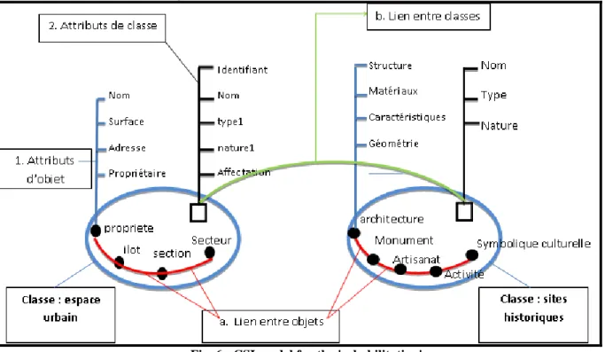
Inventory and analysis of existing data are two important operations to be performed in the design of a historical database. The paper used in this study is descriptive map of Tindouf park. The identification of two main classes [urban space and historical sites] enabled us to establish the conceptual schema information (CSI) by HBDS to extract different characteristics (figure 6).
Fig. 6 : CSI model for the 'rehabilitation'
For a projection towards the future - towards the horizon 2025- it is essential to examine the past in the sense of respect for the sacredness of the territory, memory and genius of places that guarantee the cohesion of societies and
the consolidation of their relations in shared spaces. The Conceptual Framework of Information (CFI) must meet this requirement consolidation. Any approach that advocates the denial of the territory as a place of memory and history, reducing it to a simple implementation support and distribution of archaeological remains, that can lead to an aesthetic and romantic reading of the rich history (Ministère de la culture, 2007).
5. Mapping Application
Mindful of the need to have a thorough knowledge of heritage, we must face the ongoing operation and maintenance. City maps, updated, are documents based on the restoration work and assignment. The standard plans, on paper, still retain an important place in the management and exploitation sector of cities. The number of users and their diverse requirements generally lead a technical service to develop several network plans on different scales. These are usually standardized and legislated by the Official Journal. There are several planes at different levels depending on their uses:
• Plans for small scales: they are used by the departments responsible for the planning and the development of management plans and urban master (PDAU) and are usually drawn up to a scale of 1 / 10,000.
• Plans to medium scale: plans, usually drawn up to a scale of 1 / 2,000 are accurate for locating a pipe relative to the frame and the center of the track.
• plans to major scales for congested urban areas, the above scale is insufficient and more accurate information and we joined them there, plans or diagrams to large scales (1 / 100 - 1/500) in order to accurately locate the pipes in the basement during construction. it is called execution folder that contains all the plans and profiles:
site plans to scale 1/10 000,
drawn in scale plan 1/500 or 1/1000, the longitudinal profiles and cross sections.
In this work, we approach a multiscale design using the tools of geomatics. The GIS approach is initiated to validate the structuring model, the following boards offer insight on the chronology of reassignment operations and use of the built space. Applied functions take into account the location and parameter assignment for each variable. (1)
With:
(x,y,z) : represent the location factors (Cartesian coordinates, DTM and DSM) : Thematic values related to the application (type, nature, identification).
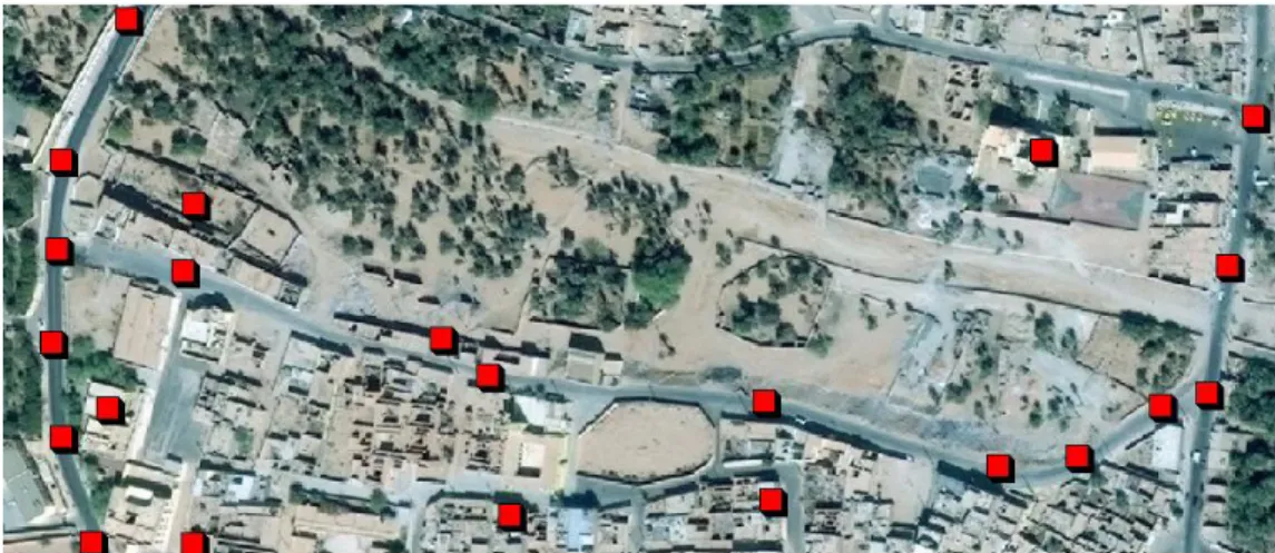
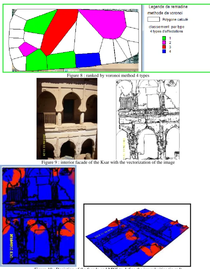
The boards made are presented for illustrative purposes to show the path of the proposed procedures for the preservation of sites and monuments. From primitive points representing sites or nodes we structure data to highlight thematic maps for the needs of the urban heritage. We present in Figure 7 the spatial distribution of the points "sites" in the area of Moussani and Remadine used in this study. It is well known that 3D reconstruction (DTM or DSM) follows an iterative process incorporating the densification of the point cloud base and the number of camera used (Sébastien R. et Al). With the number of shots is not enough, it was oriented to produce data based on orthophoto images and vectorization. These simple methods geometric image processing are of major interest for applications where multi-picture redundant configurations cannot be performed, where a picture of the formation geometry control of a single camera is required for each shot. Figures 8, 9,10 show these possibilities.
Figure 8 : ranked by voronoi method 4 types
Figure 9 : interior facade of the Ksar with the vectorization of the image
Figure 10 : Depiction of the facade and MNS to define the irregularities (in red)
Analysis and discussion
Recommendations regarding the statement of the architectural heritage depend on the needs expressed for the site; those from the specifications are intended to provide a product that best meets the expectations of needs. The products differ acquisition techniques used (laser scanning, photogrammetry, surveying), data processing and archiving. Regarding photogrammetry, recommendations mainly concern different types of acquisition (an image, a stereo pair, a block). Work completed by calculating the spatial resolution on the object, the distance of shooting and accuracy of the reading. For the acquisition of a single image, two scenarios are possible depending on the knowledge of the shape of the surface to restore the position, orientation and internal parameters of the camera (Luhman, T. and al. (2006).
The CSI established scheme has allowed us to make an inventory of the existing and implement the data to produce thematic maps. In addition, to solve the problem of hidden parts, at least two stations are used. Finally, three types
of 3D scans should be performed for each station: a scan of the monument environment, accurate scans of the building and scans at full resolution targets: an integrative approach must be defined. Furthermore, data archiving for the types of formats for each technique and structuring of all data from a statement. For both techniques, the usefulness of sizes depends on the treatment to be performed and the storage size. A first class level of structuring the data in the instrument used; a second level separated from the raw data processed data; Finally, a last level structure data from each station. Moreover, encoded file (eg XML) describes all the raw data and treatments, as well as important data as the internal parameters of the camera used (Mugnier et Watford 2004).
V-CONCLUSION
This modest contribution to studies of historical sites and buildings brings a whole new vision in integrating proximity data to actually achieve urban mapping historical sites. The study shows that the EIS model (of environmental information system) is a good solution for the treatment of reliable cartographic and geographic information and updated. Data organization and structuring of information directs us to the establishment of a
historical type of database.
On the other hand, the legal aspects are essential to achieving normative models that will revolve around an inference engine we chose in this communication "GIS". Monitoring and process management for urban space through a detailed analysis of the recorded mess on the site. The general model of interventions Database cannot be validated at the heart of this study for implementation and practical implementation of the project because we are moving towards new organizations. Finally, the guide map should contain the following documents to complete the existing standards:
Neighborhood legends, incidents and interventions EIS cards.
The general structure diagram.
The MCD neighborhood, incidents and interventions.
The quality standards.
Reliable mapping, updated and synthetic
The division of space - time interval or iteration can track the evolution of the rehabilitation work, thus avoiding degradation of the works, goods and people. When we get to the surveying of very cohesive neighborhood, it is necessary to set up a topology for queries and spatial analysis. Hausdorff distance can be a considerable contribution to these space applications (studies, simulation, operation, etc.). The adoption of a corresponding environmental data representation of historical sites should allow the establishment of fast queries systems for decision making. Example: (X, Y, Z, , , ) for a given point with i (, , ) as correlation coefficients.
References
1. ICOMOS, 1964: « Charte internationale sur la conservation et la restauration des sites et monuments », 1964,
ICOMOS, pp4.
2. De Luca Livio, « La photomodélisation architecturale : relevé, modélisation et représentation d‟édifices à partir
de photographies », 2009, Eyrolles, pp 233-263
3. Luhman, T. and al., (2006), „Close Range Photogrammetry: Principles, Methods and Application‟, Whittles
editor.
4. Gutiérrez, C. and Servigne, S. (2009), „Métadonnées et Qualité pour les Systèmes de Surveillance en
Temps-Réel‟, Revue Internationale de Géomatique, Vol. 19, N°2 pp. 151-168.
5. Bopp, H. and Krauss, H. (1980) Non topographic Photogrammetry- Manual of Photogrammetry – fourth
edition- American Society of Photogrammétry, pp. 803.
6. Mugnier, PL. and Walford, A, (2004), „Photogrammetric Applications‟ in J. Chris McGlone (ed.), Manuel of
Photogrammetry. (pp.1015 - 1103), Fifth edition, ASPRS.
7. Hagget P, « analyse spatiale en géographie humaine » édition Armand colin 1965 pp 20-50.
8. Mencl, R.,: Reconstruction of Surfaces from Unorganized 3D Points Clouds. PhD Thesis, Dortmund University 2001, Germany.
9. Sébastien R. et Al, ‘ Numérisation 3D et prototypage Rapide : Exemples d‟industrialisation de produits‟, www.techniques-ingenieur.fr
10. Delaunay, J. http://archeologie3d.blogspot.com/, 2011. Blog qui présente des exemples de restitution
archéologiques à différentes échelles.
11. François Bouillé.Cours de DESS "Application de l'Informatique aux Sciences de la Terre" 1999-2000 . 12. Haggrén, H., et al. Photogrammetric documentation and modeling of an archaeological site : the finnish jabal
haroun project. In ISPRS : Workshop 3D-ARCH 2005 on Virtual reconstruction and Visualization of Complex Architectures (2005), vol. XXXVIII/5-W1.
13. Humbert, J.-B. Statut et bilan de l‟archéologie à gaza depuis 1995 : La question du patrimoine (novembre
2010). Site internet de l‟EBAF : http://www.ebaf.info/?pageid = 1102andlang = fr.
14. ICOMOS, Charte ICOMOS pour l‟interprétation et la présentation des sites culturels patrimoniaux, 2007. 15. Jean Touffet, 1982, « Le dictionnaire essentiel d‟écologie », éd Ouest France.
Willen 1995
Internet
[Eos Systems, Inc., PhotoModeler Pro User‟s Manual, Version7, 2010, www.photomodeler.com/support/default.html]
[http://www.univie.ac.at/Luftbildarchiv/wgv/3x3.htm].
http://www.odyssey.ursus.maine.edu/gisweb/spatdb/egis.eg94103.html http://www.sbg.ac.at/geo/agit/papers94/bouille.htm