HAL Id: dumas-02971357
https://dumas.ccsd.cnrs.fr/dumas-02971357
Submitted on 26 Oct 2020HAL is a multi-disciplinary open access archive for the deposit and dissemination of sci-entific research documents, whether they are pub-lished or not. The documents may come from teaching and research institutions in France or abroad, or from public or private research centers.
L’archive ouverte pluridisciplinaire HAL, est destinée au dépôt et à la diffusion de documents scientifiques de niveau recherche, publiés ou non, émanant des établissements d’enseignement et de recherche français ou étrangers, des laboratoires publics ou privés.
Assessment of green infrastructure and its design in
vineyards
Nadège Grisard
To cite this version:
Nadège Grisard. Assessment of green infrastructure and its design in vineyards. Agronomy. 2019. �dumas-02971357�
Master thesis
presented for the degree of Agricultural Engineer
Domain: Viticulture and Oenology
Assessment of Green Infrastructure and its Design in
Vineyards
Presented by Nadège GRISARD
2019Master thesis
presented for the degree of Agricultural Engineer
Domain: Viticulture and Oenology
Assessment of Green Infrastructure and its Design in
Vineyards
Presented by Nadège Grisard
Year: 2019
Supervisor: Foued Cheriet
Presented on: 06/11/2019
Jury:
Foued CHERIET
Didier OLLE
Host University: Lincoln University,
New Zealand - School of Landscape and
Architecture (SOLA)
Supervisors:
Wendy McWilliam, senior lecturer,
Faculty of Environment, Society and
Design
Olaf Schelezki, lecturer, Faculty of
Agriculture and Life Sciences
4
R
ESUME
Titre: Evaluation des Eléments de Biodiversité et de leur Design dans les Vignobles.
La monoculture viticole menace la biodiversité en occupant des habitats clés et en simplifiant les communautés écologiques. La simplification des paysages est reconnue comme étant une raison des invasions d'insectes ou de maladies depuis plusieurs dizaines d'années maintenant. Des changements qui ne modifient pas radicalement la nature monoculturale des agrosystèmes peuvent temporairement réduire les impacts négatifs, mais pour une réelle résilience et des bénéfices durables, des mesures agro-écologiques radicales sont nécessaires. La diversification réfléchie des écosystèmes incluant un design de la biodiversité comme l'agroforesterie est un exemple. Dans les systèmes viticoles, l'utilisation de plantes de couverture est souvent le seul outil de management basé sur la biodiversité. Un plus large panel d’Éléments de Biodiversité (végétation autre que la vigne ainsi que le réseau d’eau, appelées Green Infrastructure (GI) en anglais), comme des réserves d’insectes ou haies, doit être utilisé comme outil de travail pour une approche systémique allant vers des agrosystèmes plus équilibrés, utilisant des insectes prédateurs pour combattre les parasites et des buissons pour réguler les flux d'air.
Alors que les connaissances sont nombreuses sur les bénéfices de l'incorporation de plus de biodiversité pour diminuer les impacts négatifs de la monoculture, ainsi que pour fournir des services écosystémiques, seulement peu d'études existent sur sa mise en place dans les vignobles. De même, très peu d'études cherchent à comprendre si le design de la biodiversité dans les vignes résulte d'une action volontaire ou alors, si et comment, il est planifié. La biodiversité en tant qu'outil ne semble pas faire partie du processus de plantation même dans les régions viticoles récentes.
Des interviews longues semi-structurées ainsi que la cartographie des GI sont les méthodes utilisées dans la région viticole de Waipara pour comprendre comment les vignerons choisissent la localisation de la biodiversité et pour identifier les GI présentes dans les vignes. Aussi, pour augmenter la prise de conscience sur le sujet, les résultats seront diffusés de façon compréhensive et informative avec les interviewés.
Cette étude montre que le processus de design des vignobles n'inclut pas l'incorporation de GI et l'utilisation de cartes des vignobles est très limitée. La présence de GI est faible et principalement limitée à des zones non exploitables pour une production viticole. Trois types de design ont été identifiés : des vignobles conventionnels homogènes, des fermes conventionnelles utilisant des haies, et des fermes plus diversifiées. La présence d'un caveau de dégustation ou d'un Airbnb sur la propriété augmente la présence de biodiversité alors que la certification ou la taille du vignoble n'est pas un facteur explicatif majeur. Fournir des cartes et une évaluation personnalisée de la biodiversité sur les domaines vise à augmenter la conscience des vignerons vis-à-vis de leur biodiversité et à leur donner des outils de planification. Puisque la biodiversité présente sur chaque propriété est insuffisante pour former un réel réseau, il serait judicieux de travailler à l’échelle des paysages avec l’implication d’acteurs régionaux ainsi que d’institutions viticoles, pour lier les propriétés voisines entre elles et construire un réseau de végétation basé sur les cours d’eau.
Mots clés
Éléments de biodiversité, Biodiversité, Design, Vignobles, Vignes, Service Écosystémique, Haies.
Pour citer ce document : [Grisard, Nadège, 2019. Assessment of Green Infrastructure and its Design in Vineyards . Mémoire de fin d’étude d’Ingénieur Agronome, Option Viticulture-Œnologie, Montpellier SupAgro. 30p.]
A
BSTRACT
Title: Assessment of Green Infrastructure and its Design in Vineyards.
Vineyard monoculture poses a threat to biodiversity by occupying key habitats and simplifying ecological communities. Landscape simplification is known as a cause of insect and disease outbreaks for a few decades now. Changes that will not radically modify the monoculture nature of agrosystems may moderate negative impacts temporarily. Though, for real resiliency and durable benefits, radical agroecological measures are needed to strengthen farming resiliency. Diversification of agrosystems in the form of biodiversity-wise designed systems such as agroforestry are such measures. In vineyard systems, cover crop is often the only biodiversity feature part of the farming strategy. A broader range of Green Infrastructure (GI, non-vine vegetation and water-systems) such as insectaries and hedgerows would be necessary for a systemic approach to better-balanced agrosystems, using predatorial insects to fight pest and shrubs for regulating airflow.
While a great deal is known about the benefits of incorporating more biodiversity to mitigate negative impacts of monocultural farming, and to provide an increase of ecosystem services (ES), little study of its implementation within vineyards exists. Nor much study about whether vineyard owners purposely design for greening and how. Biodiversity as a tool does not seem to be part of the planting process even in new wine regions.
Semi-structured long interviews and GI mapping are used in Waipara Valley wine region to understand how winegrowers make decisions about the incorporation of GI in vineyards and to locate them. Also, to increase farmer awareness, results will be shared in a comprehensive and informative way with the interviewees.
The study shows vineyard design process doesn't include GI, and the use of farm maps is very limited. GI presence is low and mainly limited to areas that aren't suitable for production. Properties show three types of design: conventionally designed homogeneous vineyards, conventionally designed farms with the use of hedgerow and more diverse vineyard farms. The cellar door or Airbnb presence on properties increases the GI whereas certification or vineyard size are not major factors. Providing managers with a personal map and a biodiversity assessment as feedback is aiming at increasing their awareness on their biodiversity and give them a designing tool. As patches on each property are too limited to support a real biodiversity network, it would be good to work on a landscape scale with the involvement of regional and wine organisations to bind neighbouring properties together and build a biodiversity network based on waterways.
Key words
Green Infrastructure, Non-Vine Plantings, Biodiversity, Design, Vineyard, Shelterbelt, Hedgerow, Cover crop.
6
A
CKNOWLEDGEMENTS
I would like to thank Steve Wratten and Collin Meurk from Lincoln University for starting and leading the Greening Waipara Programme project, innovative idea to try to improve biodiversity presence in Waipara’s vineyards.
Thanks a lot as well to Olaf and Wendy, my supervisors at Lincoln, knowledgeable resources I could rely on when necessary. Thank you Foued for your valuable advice and quick reply all the internship long.
My biggest acknowledgment probably goes to the interviewees. Despite their busy schedule, they spent time to reply our questions as well as sharing their passion and knowledge about winegrowing. It is good to hear blunt and honest people sharing their practical experience and see things in a way different from French traditional practices.
Thanks to my workmate Anna-Kate, I enjoyed the trips to Waipara with you. Thanks as well to Johanna, Axelle, and Alexandre for the nice lunch break chats.
Thank you, Bruce, for hosting me in your beautiful vineyard and cattle lifestyle block. It was good to practice pruning, learn about cattle breeding and share thoughts about sustainable farming. I enjoyed your daily company a lot during these six months, as well as Brieuc's and Shep's.
Thanks to my friends, 015 classmates and family back in France for your remote support. It was nice to be hosted in Lincoln University facilities and it is a really good thing Montpellier Supagro enables its students to get experience abroad and granting me a scholarship. Thanks to Occitanie region too for the financial support.
This experience has not only helped build up my theoretical knowledge about biodiversity design but as well to comfort it by practical feedbacks about existing implementation and design around vineyards.
T
ABLE OF CONTENT
INTRODUCTION ... 15
1 WAIPARA VALLEY, A WINE REGION IN NEW ZEALAND ... 16
1.1 New Zealand ... 16
1.1.1 General presentation ... 16
1.1.2 New Zealand vegetation history ... 16
1.1.3 Water management and pollution (Cullen et al., 2006) ... 17
1.2 New Zealand wine industry ... 17
1.2.1 Production characteristics ... 17
1.2.2 Landscapes simplification ... 18
1.2.3 Sustainable Winegrowing NZ (SWNZ) ... 18
1.3 Waipara wine region ... 18
1.3.1 Wine history and economic system (Schuster et al., 2002) ... 18
1.3.2 Waipara climate and soils (Schuster et al., 2002) ... 19
1.3.3 Main specificities production challenges in the region ... 19
1.3.4 Greening Waipara Programme ... 20
2 BIODIVERSITY DESIGN IN VINEYARDS ... 21
2.1 Resilient farming systems ... 21
2.1.1 Biodiversity inclusion in sustainable farming certifications ... 21
2.1.2 Hedgerow/shelterbelt use as a vineyard management tool ... 22
2.1.3 Ecosystem services (ES)... 23
2.2 Design of biodiversity around vineyard farms ... 24
2.2.1 Vineyard establishment recommendation ... 24
2.2.2 Farm plan use by vineyard managers ... 24
2.3 Study objectives ... 25
3 METHODS ... 26
3.1 Sample ... 26
3.2 Research design ... 26
3.2.1 Interview ... 27
3.2.2 Mapping field data gathering ... 28
3.3 Data transcription ... 28
3.3.1 Interview transcribing – 19 scripts ... 28
3.3.2 Digitizing process – 20 properties ... 28
3.3.3 Layers and data subdivision presentation ... 29
8
3.3.5 Classification ... 30
3.3.6 Extraction / correlation ... 31
3.4 Data analysis ... 31
3.4.1 Qualitative analysis of data from the interview ... 31
3.4.2 Analysis of the mapping data ... 31
3.5 Feedback ... 32
4 RESULTS ... 33
4.1 Vineyard design process ... 33
4.1.1 Behaviour toward vineyard design ... 33
4.1.2 Farm map ... 36
4.1.3 Zones analysis ... 37
4.2 Biodiversity layout in Waipara Valley ... 38
4.3 Factors of influence on property design ... 38
4.3.1 Principal Component Analysis ... 38
4.3.2 Hierarchical Clustering results ... 39
4.3.3 Cluster description ... 39
4.4 Feedback ... 40
4.4.1 Personal Feedback ... 40
4.4.2 Personal Farm map ... 41
5 DISCUSSION ... 41
5.1 Biodiversity design assessment ... 41
5.1.1 Vineyard presence and design ... 41
5.1.2 Use of mapping ... 42
5.1.3 Factors impacting design of biodiversity... 42
5.2 How to improve the use of biodiversity design within vineyards towards more complex agrosystems?42 5.3 Further analysis of the data ... 43
L
IST OF FIGURES
Figure 1: World map locating New ZealandFigure 2: A snapshot of NZ wine (NZWine, 2019)
Figure 3: Evolution of the grapevine area in Canterbury over the past 11 years Figure 4: Sample location – red rectangle is the study area
Figure 5: Vineyards location map
Figure 6: Distribution of the size of vineyards in the sample, percentage of properties
Figure 7: Distribution of the size of vineyards in Waipara, percentage of properties (NZWine, 2019) Figure 8: Distribution of the size of vineyards in NZ, percentage of properties (NZWine, 2019) Figure 9: Interview script sub-sections
Figure 10: ArcMap interface and drawing of a polygon identifying a Green Infrastructure in sky blue. Figure 11: Zone types distribution in Waipara
Figure 12: Percentage of vineyard zone in each property
Figure 13: Percentage of 'Boundary', 'Building' and 'No use' zones in each property. Figure 14: Vegetation type distribution in Waipara’s GI
Figure 15: Native percentage distribution in Waipara’s GI Figure 16: Percentage of GI in each zone type
Figure 17: GI repartition in between the different zone types Figure 18: Percentage of GI and hedgerow in each property. Figure 19: Wetland surface area and types
Figure 20: Water features presence by property.
Figure 21: Graph of variables – Principal Component Analysis
Figure 22: Graph of individuals - Principal Component Analysis - Confidence ellipses related to the certification
Figure 23: Graph of individuals - Principal Component Analysis - Confidence ellipses related to the vineyard size
Figure 24: Graph of individuals - Principal Component Analysis – Confidence ellipses related to the management type
Figure 25: Graph of individuals - Principal Component Analysis - confidence ellipses related to the presence of a cellar door or a Airbnb
Figure 26: Hierarchical tree and identified clusters Figure 27: Factor map of clusters
Figure 28: Property 7 - Cluster 1 – Conventionally designed homogeneous vineyard properties
Figure 29: Property 6 - Cluster 2 - Conventionally designed vineyard properties with use of hedgerows Figure 30: Maps legend
Figure 31: Property 5bis - Cluster 3 - More diverse vineyard farms Figure 32: Property 1 - Cluster 4 - Outsiders
Figure 33: Property 19 - Cluster 4 – Outsiders Figure 34: Personal Feedback page 1 - Property 6 Figure 35: Personal Feedback page 2 - Property 6 Figure 36: Farm map Feedback - Property 5bis
10
L
IST OF TABLES
Table 1: Interviewed properties descriptionTable 2: Digitizing process associated to the part of the property considered (: is digitized,: isn’t digitized)
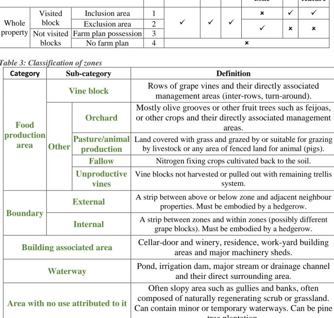
Table 3: Classification of zones
Table 4: Classification of Green Infrastructure
Table 5: Key assessing the presence of native species in Green Infrastructure Table 6 : Key identifying the number of species in Green Infrastructure Table 7: Key identifying the water feature
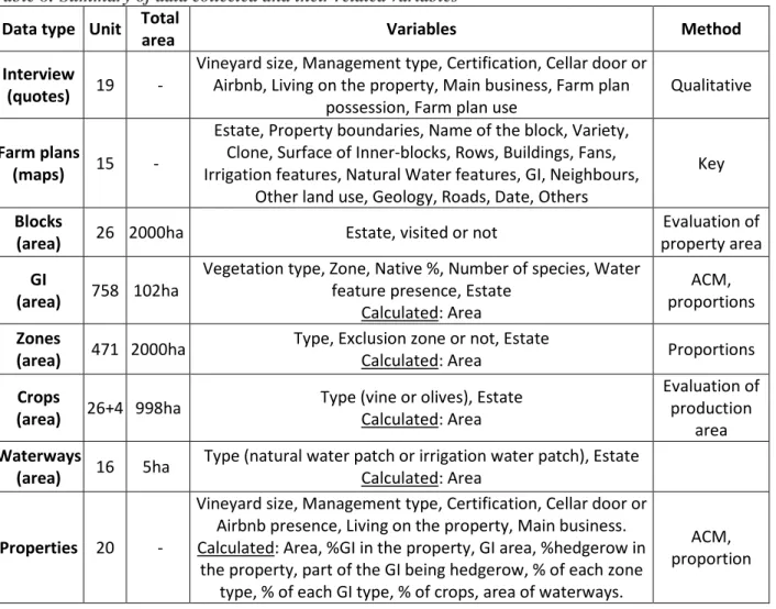
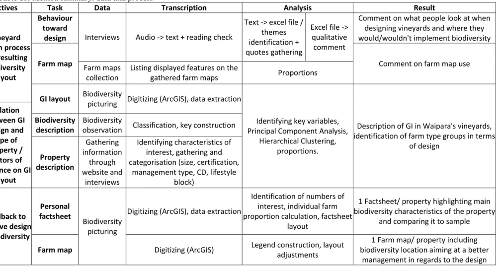
Table 8: Summary of data collected and their related variables Table 9: Key of analysis stating in what way a theme was mentioned Table 10: Method summary: data and process
Table 11: Contribution of variable to Principal Component Analysis axis Table 12: Cluster characterisation
F
OREWORD
This study is completed at Lincoln University following Wendy McWilliam previous work in Oregon evaluating a biodiversity-based wine grape production system. The interview process is done along with Anna-Kate Goodall’s master thesis study about Enablers and Barriers of GI in vineyards.
12
G
LOSSARY
Biodiversity: Consists of plants that provide ecosystem services such as nitrogen fixation,
decomposition, facilitation of nutrient uptake by plants, pollination, pest control and ecosystem engineering (Moller et al., 2008).
AirBnB: Airbnb is an online marketplace for arranging or offering lodging, primarily
homestays, or tourism experiences.
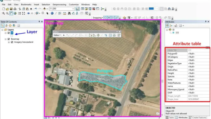
Basemap: Refers to a collection of GIS data and/or orthorectified imagery that forms the
background setting for a map. The function of the basemap is to provide background detail necessary to orient the location of the map. Basemaps also add to the aesthetic appeal of a map [Webography, 5].
Biodiversity trail: Bush planting with a path and informative signs for customers to discover
NZ natives, set up by Greening Waipara programme.
Block: Vineyard block consists of rows of grapevines and their directly associated
management areas, which consist of inter-rows, tractors turn-around areas at the end of grape-vine rows, and inter grape-vineyard block roads (McWilliam, draft).
Cellar door (CD): consists of the building in which the wine is sold to the visiting public, in
addition to its associated landscaped areas, driveways and parking (McWilliam, draft).
Corridor: A corridor is an area of habitat connecting wildlife populations separated by
human activities or structures (such as roads or fields).
Cover: Is the area of ground covered or the relative proportion of coverage a particular plant
species, vegetation layer or plant form represents (Lee et al., 1998).
Cover crop: Plant such as rye, alfalfa, or clover that are planted in between the main crop in
order to maintain a plant cover on the land and thus reduce erosion and leaching (Park, 2007).
Crop: Plant grown for food (2006).
Drainage channel: a ditch or open channel that is used to carry excess water or sewage
downstream (Park, 2007).
Farm map: Map showing much of the farm inventory. Can graphically show the natural and
cultural features present on the farm and their spatial relationships (Padgett-Johnson, 2003).
Gully: A gully is a long narrow valley with steep sides [Webography 4, Collins].
Green Infrastructure (GI): For winegrape production systems we define it as networks of
natural, semi-natural or human-constructed/planted non-vine vegetation and water-systems that may or may not contribute directly or indirectly to production, and provide ecosystem services and functions to vineyard farmers and their communities (McWilliam, draft).
Hedgerow: A hedgerow is a row of bushes, trees, and plants, usually growing along a bank
bordering a country lane or between fields [Webography 4, Collins].
Irrigation reserve/dam: open-top water pool storing water for irrigation and frost protection. Land sharing or wildlife-friendly farming: integrates conservation and production within
more heterogeneous landscapes (opposed to land sparing, homogeneous areas of farmland are managed to maximize yields, while separate reserves target biodiversity conservation) (Fischer et al., 2008).
Meadow: An area of closed herbaceous (pertaining to or resembling an herb or a non-woody
plant stem) vegetation dominated by grasses (Lewis, 2002).
Nor’wester: wind from the North-West, typically strong in Waipara Valley.
Patch/polygon: An area of vegetation that has a uniform structure and composition, and
differs from the surrounding vegetation (Park, 2007).
Collins].
Pond: pool of still water, often artificially created (Park, 2007).
Shapefile: The shapefile format is a common format for storing vector GIS data. Shapefiles
store non-topological vector data along with related attribute data [Webography, 5].
Shelterbelt: a row of trees providing shelter from the wind [Webography 4, Collins].
Shrub: A low woody perennial plant that has no trunk but several major branches at or near
the base giving a bushy appearance, usually less than 6m tall (Park, 2007).
Stream: A natural body of running water that flows along a channel (Park, 2007).
Tree: A large perennial woody plant that usually has one main trunk, a number of branches,
and a crown of foliage (Park, 2007).
Wastewater: Wastewater is water which has been used in people's houses or in industrial
operations [Webography 4, Collins].
Weeds: A weed is a wild plant that grows in gardens or fields of crops and prevents the plants
that you want from growing properly [Webography 4, Collins].
Wetland: Land that is partially or totally covered by shallow water, with soil saturated by
moisture part or all of the time (Smith, 2011).
Winery: consists of the structures associated with wine production in addition to its
14
A
BBREVIATIONS
ArcGIS: Architecture GIS, a suite of desktop softwares developed by ESRI (Environmental
Systems Research Institute).
ArcMap: Architecture Map, software part of ArcGIS suite.
CD: Cellar Door
DDs: Degree Days
ES: Ecosystem Services
GI: Green Infrastructure
GIS: Geographic Information System
GW: Greening Waipara
GWP: Greening Waipara Programme
HC: Hierarchical Clustering
ID: Identification number
NZ: New Zealand
NZW: New Zealand Winegrowers; New Zealand Winegrowers is the national organisation
for the country's grape and wine sector.
OIV: International Organisation of Vine and Wine
PCA: Principal Component Analysis
SWNZ: Sustainable Winegrowing New Zealand; an industry-wide certification programme
I
NTRODUCTIONAgriculture is the single largest cause of biodiversity loss, greenhouse gas emission, consumptive use of freshwater, loading nutrients into the biosphere (nitrogen and phosphorus) and a major cause of pollution due to pesticide. Conventional viticulture is among the most pesticide consuming agricultural systems (Provost and Pedneault, 2016) and grape production internationally has intensified with more grapes produced on a decreasing land area (OIV, 2012), and is thus well part of that picture.
Current management systems can temporarily mitigate the negative implications of monocultural systems, but radical agroecological strategies and techniques breaking severe monocultures are needed to re-establish a systemic resilience (Cox and Underwood, 2011; Altieri et al., 2015). Landscape simplification is known as a major driver in the increased pest and disease outbreaks observed over the last few decades. (Andow, 1983; Barbosa and Schultz, 1987). However, even in new wine regions such as Waipara Valley, Green Infrastructure (GI) is rarely part of the planting process. Green Infrastructure is defined for winegrape production systems as networks of natural, semi-natural or human-constructed/planted non-vine vegetation and water-systems that may or may not contribute directly or indirectly to production, and provide ecosystem services and functions to vineyard farmers and their communities (McWilliam, draft). In vineyard systems, for example, cover crop is often the only biodiversity feature that is part of the vineyard management. Amending cover crop with other non-vine plantings such as insectaries to support predatorial insects or hedgerow and shrubs management to optimise airflow may hereby create better-balanced agrosystems. Such strategies and techniques include the diversification of agroecosystems by implementing biodiversity enhancing systems such as agroforestry. ‘Everyone in the world
depends on nature and ecosystem services to provide the conditions for a decent, healthy, and secure life. Humans have made unprecedented changes to ecosystems in recent decades to meet growing demands for food, fresh water, fiber, and energy. Human activities have taken the planet to the edge of a massive wave of species extinctions, further threatening our own well-being.’ These three statements are part of the outcomes from the Millenium Ecosystem
Assessment (Millenium Ecosystem Assessment Board, 2005). This report called for by the United Nations has been built up by a group of 1360 experts worldwide and the robustness of its findings had been scrutinized by governments and independent scientists. Going toward a resilient farming system based on ecosystem services appears as the key.
In New Zealand, despite the very recent human arrival, landscapes have been badly degraded, and keep on degrading with indigenous species extinction still occurring. Thus the population and the government are trying to protect the remaining natives and implement more. Though, biodiversity does not appear to be part of the recently developed vineyard landscapes. Recent vineyards means that people who planted and designed them are often still owning them. Thus it is possible to get in touch and try to understand why so little vegetation has been planted even when the importance of biodiversity was already documented. As Waipara Valley Wine region has been through a greening programme (Greening Waipara Programme, GWP), that should have increased biodiversity presence and stakeholder’s awareness about ecosystem services and make the discussion a bit more documented.
It is why I seized the opportunity to work in a research environment on the design aspects of Green Infrastructure in vineyards. At Lincoln University, New Zealand (NZ), my work was supervised by Wendy McWilliam, an expert in biodiversity landscaping, together with Olaf Schelezki, an expert in grape and wine production. Previous work by Wendy McWilliam in Oregon (not published yet), ‘An evaluation of biodiversity-based wine grape production systems’ is assessing the role of biodiversity in vineyards in Oregon. She found that little
attention was given to increasing the resilience of vineyard systems through either GI or additional production systems. “Designing and managing production and GI as integrated systems, versus isolated components, across expanded spatial and time scales, would assist in minimizing externalities, maximizing ecosystem services, and enhancing resilience. In addition, further research is also required to test alternative designs in support of stakeholder ecosystem services to demonstrate effectiveness and enable implementation” (McWilliam, draft).
This study is aiming at understanding the design strategies in vineyards and studying the resulting biodiversity layout. Properties involved in Greening Waipara Programme were interviewed about the design process of their vineyard and their use of a farm plan. A mapping process of biodiversity presence has been undertaken as well while visiting the vineyards. Data are collected during an interview process completed along with Anna-Kate Goodall’s Master project about Enablers and Barriers of GI.
After a background presentation of the study area as a wine-producing region in New Zealand, we will identify the research objectives and then have an overview of the different concepts it embraces. Then the method will be detailed before results are presented and discussed.
1
W
AIPARAV
ALLEY,
A WINE REGION INN
EWZ
EALAND1.1
New Zealand
1.1.1 General presentation
New Zealand, or Aotearoa (Māori name), is a very rural country, half the size of France, and an average density of 18 people per square kilometre (2017) [webography, 1]. Of the 4.7 million New Zealanders, approximately 69% are of European descent and 14.9% are indigenous Māori, the first settlers. Thus, names of places, fauna, and flora can be either from English or Māori descent. Sitting in the south-western Pacific Ocean between latitudes 34°S and 47°S (Figure 1), it consists of two main islands that are narrow (maximum width is 400 km) and called the North Island and the South Island. NZ has a temperate marine climate with cooler summers and milder winters than comparable latitudes in the northern hemisphere (Howland, 2014). Thus, even if Waipara Valley is 43°S, i.e. opposite to Narbonne (Franch city), it is a cool climate viticulture. Waipara Valley (means Muddy Water Valley in Māori) is located in the North Canterbury wine region, the main city of the region is Christchurch (see Figure 4).
1.1.2 New Zealand vegetation history
NZ is geographically isolated land for millions of years, it got split from Australia about 80 million years ago. Thus flora and fauna adapted and evolved independently from its progenitors (Newsome, 1987). Its long insulation from other lands and latitudes extending from subtropical to Subantarctic leads to a unique flora and highly diverse vegetation (Wardle, 1991). Indigenous biodiversity is called native.
NZ colonisation by humans is very recent and brought along a massive biodiversity loss. The earliest conceivable arrival was about 750 AD (Newsome, 1987), with Polynesian repeated accidental colonisation. The Maoris used fire as a tool in hunting Moa (extinct indigenous giant bird), clear land for food crops and open routes. The forest, covering a major part of NZ land, reduced from approximately 75% between 750AD and 1800AD (Newsome, 1987). With the year 1840 and the start of the European era comes along with more fire land
clearing and the start of extensive sheep grazing. By the middle of the 20th century, all the plains and downlands had been cleared of forest and scrub and converted to agricultural use. On top of that destructive behaviour, the early settlers had brought with them an array of exogenous plants, mammals and birds. Many of those introduced species had little impact, but others soon became nationwide pests and still are today. One consequence has been the impact on forest health and regeneration capability, including loss of vigour and death of palatable trees, increased susceptibility to diseases, reduction or loss of understory shrubs and seedlings. Some naturalised exotic flora species thrive (such as gorse (Ulex europaeus), sweet briar (Rosa rubiginosa), broom (Cytisus scoparius), thistles, etc.) and spread around as weeds, jeopardising significantly agricultural practices, or harming indigenous species as the Pinus
contorta.
Recently, these issues around environmental conservation has received wider public attention and focus has been given to land planning, district, and regional schemes, reserves creation, etc. Land and people co-existing in harmony is still far in the future but it is a general aim for NZ (Newsome, 1987).
1.1.3 Water management and pollution (Cullen et al., 2006)
The ongoing availability of freshwater used to be taken for granted in New Zealand. However, this time is long gone, with demand for water increasing steadily in several regions of New Zealand and availability is limited, particularly during low-rainfall periods. Diffuse sources of nitrates have caused nitrification of several NZ lakes, many streams, and some major aquifers. Agriculture is recognized as a major cause of this declining water quality, particularly because of its intensification and the growth of dairy farming. Agricultural irrigation has increased at a rate of about 55 percent per decade between 1965 and 2006. Water resource allocation and water quality are issues of national importance.
1.2
New Zealand wine industry
1.2.1 Production characteristicsWine industry in NZ is very young. Even though the first vines were planted in the early nineteenth century, there was only 388ha across NZ in 1960 (Moran, 2016). In 2019, about 39 000ha are planted in NZ (Figure 2, (NZWinegrowers, 2019)) and growth is ongoing with a 3% increase from 2017 to 2018. Responsible for just 0.7% of global production in 2010, NZ built up its fame with its Marlborough Sauvignon blanc. (Howland, 2014). 7% of New Zealand’s vineyard producing area operating under recognised certified organic programmes (SWNZ, 2016). Marlborough wine region is quite intensive, with high yields and 69% of the national area. With 3% of it, Waipara Valley wine region sits far behind, and other types of agriculture remain important. Yield in Canterbury reaches an average of 7.7 t/ha in 2018 (2018 being a quite high yielding year for the region), the average NZ yield is 11.1t/ha (NZWinegrowers, 2018). The total production of 300 million litres is mainly exported (85% exported in 2018).
In Brief
NZ native biodiversity is fragile and endangered. Only rare patches remain in agricultural landscapes when exotic species spread. Water is available but recently became scarce in some regions.
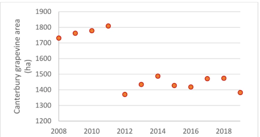
Figure 3: Evolution of the grapevine area in Canterbury over the past 11 years 1200 1300 1400 1500 1600 1700 1800 1900 2008 2010 2012 2014 2016 2018 C a n te rb u ry g ra p e v in e a re a (h a )
1.2.2 Landscapes simplification
This wine industry tremendous growth results in landscapes simplification and vineyard monoculture in Marlborough, and in parts of Gisborne and Hawke’s Bay landscapes. Not only they are less aesthetically desirable than the smallholding, but the use of pesticides and fertilisers is higher, and disease risk more prominent. (Pawson, 2018)
1.2.3 Sustainable Winegrowing NZ (SWNZ)
Singular thing in New Zealand is the presence of a national sustainable certification, Sustainable Winegrowing New Zealand (SWNZ), introduced commercially in 1997 and adopted by grape growers across the country’s winegrowing regions: 98% of NZ’s vineyard area is SWNZ certified (NZWinegrowers, 2018). The Sustainable Winegrowing New Zealand programme is based on continuous improvement and adherence to recommendations and guidelines issued by the International Organisation of Vine and Wine (OIV). SWNZ was developed to provide 'best practice' model of environmental practices. SWNZ ensures members meet international standards for sustainability practices while helping the environment, businesses and local communities to thrive. Sustainable winery certification standards were established in 2002 and adopted by New Zealand wineries, closing the circle on the industry’s sustainability commitment.
1.3
Waipara wine region
1.3.1 Wine history and economic system (Schuster et al., 2002)
The planting of grapes in Waipara in the 1960s arose from the need to find alternative crops in an area of economically marginal, relatively small sheep farms with a difficult climate prone to prolonged summer drought. Thus Glenmark irrigation scheme was developed in the 1970s to give economic viability to traditional farms (fat lambs, wool, wheat, barley, and ryegrass). It turned out to allow as well possibilities of new ways of farming, now the area is well suited to the production of many horticultural crops including vineyard grapes. Availability of irrigation water remains a limiting factor to a rapid expansion of vineyards in Waipara, although all of the present vineyards do so with apparent ease and have found sufficient water on their sites. Waipara wineries range from large producers to smaller, boutique properties. Most are open to the public for tastings, winery tours or restaurant meals. In 2008-2009, following the financial crisis of 2008, Sauvignon blanc sales dropped which caused a ‘Savi mountain’. Grape prices dropped and contracts were cancelled, provoking a lot of economic issues to wine companies. Thus, many companies were bankrupted and changed hands around that time (personal communication during interview phase). It probably explains as well as is confirmed by the major grapevine area decrease from 2011 to 2012 (reduction of 400ha), see Figure 3.
Waipara is a small producers region of 1316 ha (3% of NZ) (NZWinegrowers, 2018). There are a couple of bigger properties but their production environment makes it hard to compete with Marlborough yield-based strategy. Fruit and wine quality is usually said to be high, and they are starting to get known for Pinot noir. Though, Waipara wine region doesn’t have a common marketing strategy nor an image even nationally-speaking. Thus they have a
In Brief
NZ wine industry is less than 60 years old. Vineyard area now reaches 39 000 ha.
19
harder time to make their business profitable, especially as supermarkets have pushed the price of wine down. There used to be a Waipara Valley wine association but they recently merged with other wine areas in Canterbury to become the North Canterbury Wine Region. Most vineyards are grazed by sheep at least over winter time and sometimes as well for leaf-plucking.
1.3.2 Waipara climate and soils (Schuster et al., 2002)
In Waipara, a range of coastal hills protects the area from the cold and persistent north-easterly winds (up to 100 more degree days (DDs) than exposed Canterbury plains). Temperatures are often similar to the Marlborough district, and Waipara is regularly one of the warmest spots in NZ. With annual DDs between 950 and 1050, it is suitable for grape growing as a cool climate region.
Canterbury plains have an annual average of 650mm rain. Irrigation is required in most vineyards for establishment, and in those with low water retention, for continued production. Dry autumn weather reduces the incidence of fungal diseases close to harvest. The soils are moderately heavy clay loams, rich in ironstone and chalk, and have similarities to soils in Burgundy. But important variations across the valley soils is mentioned in interviews. Riesling does particularly well, and some vineyards have produced good wines from Cabernet Sauvignon, especially when blended with Merlot. Best performers so far are Riesling, Pinot noir and Chardonnay. All interviewees mentioned very dry climate (most properties use irrigation) and strong Nor’wester (wind from North-West). Wind is a major issue in some vineyards as it can damage vine shoots and trellis and is especially unpleasant for staff working in the vineyard. Others see it as a major help to reduce disease pressure.
Waipara is described as a frost-prone area, so most of the vineyards can get frosted during spring time and fans, sprinklers, and helicopters are used for frost fighting.
1.3.3 Main specificities production challenges in the region
The information in this section is from the interviews. Only facts mentioned several times are used.
Major pests and climate issues
Powdery (Erysiphe necator) is often mentioned as the major concern, especially since the
sexual strain of Erysiphe necator appeared (2013) (Cooper et al., 2015) and became especially present over the past 3 years.
Botrytis cinerea is often mentioned as an issue, more or less major depending on vineyards, but mostly a problem in years when they get very heavy fruit set and post veraison rain and cloudy cool conditions.
Birds are a major pest as everywhere in New Zealand. Especially exotic flocking birds
such as starlings (Sturnidae), silvereyes (or wax-eye, Zosterops lateralis), common blackbirds (Turdus merula) and thrushes (Turdidae). In order to protect their crop, most vineyards are netted from the start of the veraison.
Other pests
Leafroller caterpillars are sometimes mentioned as being already an issue in some vineyards
whereas it has not been recorded yet in others. Light Brown Apple Moth (Epiphyas
postvittana) is often the mentioned specie. ‘We've only really in the last couple of years started to see its impact. I don't know why it's all of a sudden, it might be the climatic sort of conditions, but now it's become quite a pest. Like climatic conditions have changed and it seems to be overwintering a lot more because it's not getting frosted out so much.’
The endemic grass grub Costelytra zealandica (Coleoptera: Melolonthinae) has been a pasture pest for more than 100 years in New Zealand. Recently, adults of this species (bronze or brown beetles) have been found feeding on horticultural crops such as vines amongst others. Adults damage vines by feeding on leaves, shoots and inflorescences and can produce a substantial defoliation, reaching in some cases 100% (González-Chang, 2016). In Waipara, they are reported as flying out from neighbours sheep pastures and impacting mostly rows on the fringes (two to ten rows). They are usually not too worried as they see it to a varying extent each year, they tend to be less of a problem when droughts occur.
Minor concern
The mealybug is the vector for the Grapevine Leafroll associated Virus 3, and is a problem in the Marlborough wine region [webography, 2] but not in Waipara yet. Most interviewees did not record any yet but think it will eventually reach the area. Only two interviewees mentioned having mealy bugs.
A lot of the first plantings were own-rooted because they did not have phylloxera back then. But within a couple of years, it started to appear so everybody moved to a grafted situation. Ungrafted plants are sometimes still present in part of the vineyards.
Trunk diseases, mostly Eutypa dieback (Eutypa lata), threaten the sustainability of New
Zealand vineyards and are becoming an increasing problem as vineyards age. Though, no preventative or remedial treatments are employed in typical New Zealand vineyard (Sosnowski and McCarthy, 2017).
Rabbits can be a big thing in NZ vineyards (dig holes, chew nets, cause trouble with new
plantings) and they try to shoot them while bird scaring. Though the population does not seem to be too high at the moment (virus released) and most interviewees were not complaining about that.
Climate change is rarely mentioned and does not seem to lead to a change in practices.
Warmer climate could lead to a higher prevalence of some insect pests. Some mentioned changes in rainfall patterns leading to more stress periods (increased late summer rainfall and reduced early summer rainfall).
1.3.4 Greening Waipara Programme
Greening Waipara Programme (GWP) is a research-driven project initiated by Lincoln University, local wine growers, the Hurunui District Council and Landcare Research. The objective was to help the area regenerate through the planting of natives. Vineyards were mostly targeted as a major industry in the area.
Stephen Wratten from Lincoln University was part of a six years government-funded programme called’ Biodiversity, Ecosystem Services and Sustainable Agriculture is a key’. Indeed, as already mentioned, government concern for biodiversity (see 1.1.2.) has become prominent. Over 6 years, they got a 2.3 million dollars fund from Foundation for Research, Science and Technology (FRST, public service department of NZ by then). It benefited not only research but as well vineyard properties of the area. It is the start of the so-called Greening Waipara Programme (personal communication from Stephen Wratten and (GWP, 2006)).
The approach was to engage individually with the property owners involved through soil analyses, mesoclimate examination, but as well taking into account they want to achieve: what areas, how big, how they want it to look, what constraints they face, and what timeframe is realistic. They were more specifically looking at services such as biological control of pests, pollination and keeping soils fertile, among many others. It aims to boost nature’s
21
In Brief
• Study area ‘Waipara Valley wine region’ stands for 3% of NZ vineyards and is included in the North Canterbury wine region. Pinot noir and Riesling are main grape varieties.
• Dry and windy climate, irrigation and frost fighting are common practices so is sheep grazing. Powdery mildew, birds and botrytis are the major pests. Other mentioned pests are leafroller caterpillars, grass grubs, mealybugs and rabbits.
• Greening Waipara Programme took place from 2005 to 2010 to increase biodiversity in vineyards (native plantings and cover crops).
overall contribution to agriculture. The Greening Waipara Project developed and introduced seven environmental innovations for Waipara vineyards and wineries to adopt (Appendix 1, GWP innovations and (Forbes et al., 2013). Though, adoption of the Greening Waipara Project was, with one exception, relatively low. The costs associated with the innovations tend to outweigh the benefits. Only one innovation has been widely adopted. The adoption of that innovation, conservation of native flora and fauna, has been heavily subsidised by the Greening Waipara Project, and its adoption has been almost costless and risk-free for winegrowers. (Cullen et al., 2013)
2
B
IODIVERSITY DESIGN IN VINEYARDSAfter presenting New Zealand context and mentioning the overall issues of agriculture and more especially grape growing, it is important to gather a baseline knowledge about what exists in terms of vineyard and biodiversity design.
2.1
Resilient farming systems
2.1.1 Biodiversity inclusion in sustainable farming certifications
Sustainable Winegrowing New Zealand
SWNZ has a dedicated ‘Biodiversity Enhancement’ section that vineyard members complete in their annual scorecard. They ask for the types of biodiversity enhancement programmes vineyards have in place (compulsory question, SWNZ comment mentions ‘Diversity of composition in non-productive areas (such as structure of headlands, windbreaks, etc.) should enhance the habitat for natural biodiversity including predators/competitors for pests. Host plants for pests should be avoided.’), the type of inter-row sward (compulsory question) and the total area contributed to protection, restoration or enhancement (non-compulsory, SWNZ comment details ‘Please include the total area of biodiversity contribution, excluding vineyard sward and off-site activities’), see Appendix 2. That last question (total area contributed to biodiversity) enable SWNZ to assess that 2500 ha was set aside for biodiversity protection, restoration and enhancement by vineyards and wineries in their 2016 biodiversity report (SWNZ, 2016).
In regards to mapping, SWNZ members are required to have a current site management plan with map(s) identifying key areas (i.e., blocks and varieties) including hazards, protected natural areas, location of chemical stores, fuels, emergency equipment and boundaries. They don’t ask members to submit their site management plan and maps annually (they simply answer ‘yes’ or ‘no’ to having them), but they are required to hold them on file and show
them to their auditor during on-site audits (personal communication from Meagan Littlejohn, systems administrator, SWNZ).
Organic
In New Zealand, BioGro and AsureQuality provide internationally recognised organic certification. BioGro organic standards states as part of the main organic principles and methods (2.1.) (BioGroNZ, 2009): a. Foster beneficial processes and interactions such as occur in natural ecosystems, thus encouraging internal stability. e. Minimise any deleterious environmental effects of particular management practices, including any that may reduce the natural diversity to the detriment of plant and wildlife habitats. Biodiversity is part of the principles but no clear standard is stated regarding its protection.
Biodynamics
Demeter NZ describes biodynamics (“biological-dynamics”) as a systems approach, where the farm, vineyard, orchard or garden is viewed as a living whole and each activity affects everything else. It is a method of organic agriculture that applies to any farm or horticultural enterprise by following a series of practical steps. The steps include: Widening the range of pasture species. Planting trees for multiple purposes. Biodiversity seems to be more important
than in organics but still no clear standard is included.
2.1.2 Hedgerow/shelterbelt use as a vineyard management tool
‘Compared with vines growing without protection from the wind, those sheltered by windbreaks exhibit (i) better budburst; (ii) larger leaves with more stomata; (iii) more clusters per shoot; (iv) longer internodes and longer shoots; (v) higher pruning weights; (vi) increased capacity to carry and ripen a crop; (vii) increasing phenolic content in the fruit.
Sheltered vines are also less susceptible to damage caused by whipping of the shoots and breakage (usually snapped off at the base early in the season). Sometimes loss of shoots can result in a potential 10-15% loss of productivity. Studies that have compared the productivity of sheltered versus non-sheltered vines tend to show around a 15% increase in yields. One South Australian study suggested that yield gains are from increases in flower cluster number rather than from percentage fruit set or berry size.
Ideally, a windbreak is permeable to the wind so that the air moves both through and other the top of the obstacle. This slows the speed of the air in the vineyard and also protects from the fastest air, which is shunted over the shelter. The latter is provided for a distance up to 20 times the height of the windbreak, so windbreaks need to be high enough to justify the area of land that they take up. However, with their use comes competition with grapevines for water, nutrients and even sunlight due to shading, especially at latitudes closer to the poles.
Judicious use of windbreaks can help in areas that are frost prone by preventing cold air from moving into a vineyard area from above (deflecting it away), though this precludes the use of deciduous plants in their make-up. However, deciduous tree shelters better allow cold air movement through them in the dormant season, which can be helpful in frost-prone areas as well. Windbreaks do require extra effort and cost to establish and maintain, take up land
In Brief
Environmental certification such as Sustainable Winegrowing NZ, Organic and Biodynamic often mention and/or highlight the importance of biodiversity but don’t have specific requirements.
23
area that could be used to grow grapes and also can be a nesting site for pest bird species; however, in certain areas, these drawbacks are countered by increased production and greater vine productivity.’ (Creasy, 2018)
2.1.3 Ecosystem services (ES)
Ecosystem services can be defined as the contribution that ecosystems make to human well-being. Highlight is put on the ecological outcomes that particular ecosystem characteristics or processes generate, which can ultimately benefit people. This definition is from the Common International Classification of Ecosystem Services CICES (Haines-Young and Potschin, 2018). This study will only consider economically valuable ES (this aspect is important as it has been identified as a main enabler for the adoption of environmental innovations (Forbes et
al., 2013)). They are as follow: pest control, disease control, micro, and regional climate
regulation and aesthetics. They were selected out of the 27 ES identified as relevant for vineyards by Winkler et al. (Winkler et al., 2017). They are always mentioned in the interview process and closely linked to design. When biodiversity is mentioned, it only includes plantings and vegetation. Soil biodiversity and quality is not part of the study.
Pest control
Pest control is usually a major concern in vineyards as insect species can directly damage the crop as well as being a vector of viruses. Insecticide is the most common pest management tool. It did not use to be a major issue in Waipara, but some concerns have been brought up during the interview process so it is part of the study. Pest control through the design of biodiversity need to be planned ahead. The development of crop monoculture and landscape simplification are known to be the cause of pest outbreak for a few decades now (Altieri et al., 1984). Though even the newly developed agricultural systems such as NZ vineyards stick to monoculture. In Portugal, for example, vineyard European Union (EU) policies led to landscape simplification from traditional hanged vineyards to monoculture. It led to less predatorial species, more grapeherbivores and a higher botrytis prevalence even with more fungicide applications (Altieri and Nicholls, 2002).
Disease control and mesoclimate mitigation
No much in the literature documents the impact of biodiversity on disease. Especially once the disease is already present all around the vineyards, it is too late to use vegetation as a barrier to their dispersal. Though, disease control is closely linked to mesoclimate regulation, as aeration, temperature and humidity are three major factors in disease contamination and spread.
Climate regulation
The presence of vegetation, especially hedgerow (see 2.1.2.), have a major impact on wind and thus, aeration, temperature and humidity around the vines. That impacts vineyard growth and integrity, grape ripeness, disease as already mentioned, as well as understory grass growth.
In Brief
Hedgerows are commonly used as a windbreak but they have to be judiciously designed
Aesthetics
Beautification is often mentioned as a major motive for planting. It is indeed the easiest service to gain and assess as being gained. It can be part of a marketing strategy along with cellar-door and AirB&B experience as well as it can be a personal preference or dedicated to staff well-being.
2.2
Design of biodiversity around vineyard farms
2.2.1 Vineyard establishment recommendationBiodiversity is rarely mentioned in grape growing reference books, and if so, it is only hedgerows or cover crops. Usual recommendation for vineyard establishment and designing are as follow: ‘Land that is less suited to grapes is better used for other supporting structures such as buildings or access ways. All of these take up valuable space, and so their placement should be planned to take greatest advantage of the land. It is important to use the soil information to help with the placement of blocks, as erosion and potential vigour of the area are two important factors that impact on future management. The block shape and size may be determined by a number of factors that may or may not be controllable. It can be defined by soil changes, access roads, source of irrigation water, row length, slope, etc. For many, minimizing the amount of variation within a management block is a desirable goal. Row orientation for most vineyards will run somewhere near north to south to allow for even ripening and fruit exposure on both sides of the canopy. If the area where the vineyard is to be established has high winds, it is worth considering establishment of windbreaks.’ (Creasy, 2018)
2.2.2 Farm plan use by vineyard managers
In vineyard management, spatial aspects often boil down to precision agriculture considerations (Smith and Whigham, 1999), with identified key opportunities being as follow. ‘Identification/delineation of spatial blocks with similar characteristics (ie site selection), specific measuring and monitoring of zones. Targeting management procedures to controllable factors. Analyses of results, in grapes and wine, compared to variables of location. Selection of grapes at harvest, based on spatial similarities.’ Nothing is mentioned about a broader landscape-based design approach.
Larger scale mapping is a recommended tool to provide information on agriculture and its impact on the environment (Adina, 2000). Mentioned advantages of mapping is the providing with ‘more information […] to understand the consequences of vineyard expansion on a landscape scale as well as what site-specific vineyard development and management techniques can be used to minimize negative impacts to agriculture in general, neighbouring landowners and the environment.’. Their method is designed for county- or regional-scale analysis to assist land-use planners, natural resource protection agencies and land conservation programs in protecting valuable environmental resources while sustaining a vital agricultural economy. Although, on a farm scale, mapping is important. ‘Maps play a useful role in the development and presentation of a farm plan. Much of the farm inventory can be shown on maps. Maps can graphically show the natural and cultural features present on the
In Brief
The study of biodiversity in vineyards is closely related to the understanding of ecosystem services that can be of interest for vineyard managers: pest and disease control, climate
25
farm and their spatial relationships.’ (Padgett-Johnson, 2003). Recommendations about farm plan development process are detailed. GIS being mentioned as one method. Though farm map use is not common practice.
2.3
Study objectives
In the context of a pretty poor status of viticulture sustainability and a general will to make progress towards biodiversity enhancement, this study aims at increasing knowledge about the existing design of biodiversity in Waipara Valley vineyards. Christ & Burrit (2011) attest in their review that collecting quantitative data on the environmental implications associated with wineries activities would support wine organisations stakeholders to make progress : “knowledge in this field remains underdeveloped and the literature would benefit from additional research designed to bring about a greater understanding of how different combinations of activities undertaken to preserve ecosystem integrity can be used to bring about tangible forms of economic and environmental improvement.” (Christ and Burritt, 2013).
In most vineyards, Green Infrastructure is not part of the design process (see 2.2.1). The use of farm map is low (see 2.2.2). In a context of vineyard simplification (see Introduction), it is consistent to assume that vineyard owner strategy is to plant as much land as possible in grapevine and plant vegetation only on land unsuitable for vine or around buildings for aesthetics (see (McWilliam, draft)). For testing that hypothesis, the central question in this dissertation asks how does the vineyard design process includes GI in Waipara wine region and what is the resulting GI layout?
Smaller properties with certification (see 2.1.1) and more involvement of the owners are likely to have more biodiversity and a better strategy design than others. It is why another question is: what types of property have a higher presence of GI and show a more developed design strategy?
Increasing knowledge of managers about biodiversity in their properties is likely to increase their will to do more (Christ and Burritt, 2013). Thus, this research seeks to address the following question: what feedback would help to improve the use of biodiversity design within vineyards towards more complex agrosystems?
In Brief
• Vineyard establishment literature typically doesn’t mention biodiversity. Occasionally value the use of windbreaks and/or of cover crops.
• Mapping can be useful on a property scale but is not very common.
In Brief
Characterise and understand the design of biodiversity around the vineyards in order to help the wine industry make progress toward sustainability.
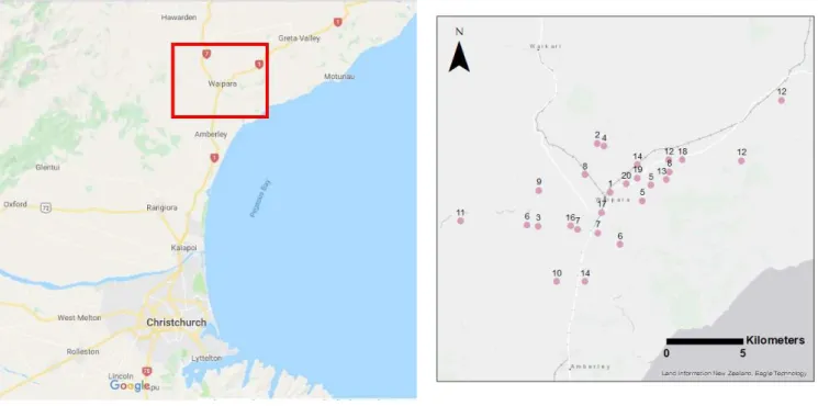
Figure 4: Sample location – red rectangle is the study area
Figure 5: Vineyards location map
Table 1: Interviewed properties description Estate
ID
Vine
(ha) Size Certification Management Tour Cellar door Main business Number of blocks 1 20 Medium SWNZ Family owned and managed Walk Yes Yes 4 2 1 Very small None Family owned and managed Walk Yes No 1 3 13 Medium Organic Family owned and managed Walk Yes Yes 1 4 4 Very small Organic Family owned and managed Drive No ? 1
5 50 Large Organic Family owned only Drive Yes Yes 2
6 70 Large SWNZ Family owned only Walk Yes Yes 2
7 210 Very large SWNZ Corporate Drive Yes Yes 3
8 3 Very small SWNZ Family owned only Walk Yes No 1
8bis 3 Very small SWNZ Family owned and managed Walk No No 1 9 20 Medium SWNZ Family owned and managed Walk No Yes 1 10 330 Very large SWNZ Family owned only Drive No Yes 1 11 23 Medium Organic Family owned and managed Drive Yes Yes 1 12 23.1 Medium Biodynamics Family owned and managed Walk Yes Yes 3 13 9 Small SWNZ Family owned and managed Walk Yes Yes 1
14 200 Very large SWNZ Corporate Drive No Yes 2
15 Not part of GWP
16 7 Small SWNZ Family owned and managed Walk No No 1
17 1.5 Very small SWNZ Family owned and managed Walk Yes No 1 18 6 Small Organic Family owned and managed Drive No Yes 1 19 0.5 Very small None Family owned and managed Walk Yes No 1
26
3
M
ETHODS3.1
Sample
This study aims at studying the design of GI in vineyards. It is interesting to study the design aspects in NZ as it is a very recent wine-producing country so most owners and managers planted their vineyard and remember the design process of it. Regarding biodiversity, it is more interesting/relevant to interview people that are aware of biodiversity role in order to have some informative and diverse conversations. The Greening Waipara Programme is the only example of a greening programme in NZ and aimed at increasing biodiversity presence as well as stakeholder’s awareness about ecosystem services. Thus, properties that were part of Greening Waipara Programme were selected for the case study.
Properties are spread out in an area around Waipara township, 14kms North/South and 22kms East/West (Figure 4 and Figure 5). A total of 998ha of vineyard are owned/managed by the interviewees, i.e. 75% of the vineyards in Waipara Valley, and a total digitized area of 2000ha. 10% of the sample surface area is certified organic which is slightly higher than the 7% in NZ. All properties part of GWP that still exist have been contacted and accepted to be interviewed (Table 1). The most recent contact list of involved wineries was used – about 50, last updated in 2009. As many properties had changed hands since, a lot of them haven’t been reached (phone line lost, outdated email). The 20 properties had either experienced the programme process or bought vineyards that had plantings from it. Main attributes of each property are gathered in Table 1. Estate ID (identification number) will enable to identify each property without naming in order to preserve anonymity. Amongst the interviewees, 11 of them had actually been part of the planting/designing process of their vineyards, whereas 7 were only part of the company afterward or bought the vineyard already planted. Half of them are living on the farm property. Property size distribution is shown in Figure 6.
In terms of vineyard size, the sample is representative of vineyards in Waipara (Figure 6 and Figure 7), except that the sample has one more vineyard over 100ha (probably explained by the fact one property lease most of its land), and less vineyard in the category 5-10ha than Waipara. It covers about 75% of the regional vineyards. Still, in terms of vineyard size, Waipara is very representative of vineyards in NZ (Figure 7 and Figure 8). Though it only stands for 3% of NZ vineyards, which is really low. 10% of the sample surface area is certified organic which is slightly higher than the 7% in NZ.
Summary
Interview process of vineyard managers or owner of 19 properties that were part of the Greening Waipara Programme. The sample is quite representative of NZ vineyards in terms of property size.
3.2
Research design
Interview questions (see 3.2.1. and 3.4.1.) will help understanding vineyard owners behaviour toward design, while mapping (see 3.2.2.) will enable to assess the biodiversity presence. Putting both in relation will enable to understand the vineyard design process impact on the Green Infrastructure layout. To understand what types of property have a higher presence of GI and show a more developed design strategy, analysis based on the mapped data will be processed (see 3.4.2.). In order to share results and answer the question about feedback helping to improve the use of biodiversity, a personal feedback will be put together (see 3.5).
Figure 6: Distribution of the size of vineyards in the sample, percentage of properties
Figure 7: Distribution of the size of vineyards in Waipara, percentage of properties (NZWine,
2019)
Figure 8: Distribution of the size of vineyards in NZ, percentage of properties (NZWine,
2019)
1 - Background information. 2 - Design planning.
3 - What non vine plantings existed, were planted and are currently in participant vineyards?
4 – To what extent does the GI planted mitigate key environmental impacts and increase ecological services?
5 – How might GI effectiveness be improved?
6 – How might GI be increased in the vineyard? What are the enablers or barriers for its implementation?
Figure 9: Interview script sub-sections <5ha 35% 5-10ha 15% 10-20ha 15% 20-50ha 15% 50-100ha 5% >100ha 15%