D
istrict
& M
unicipal
l
anD
u
se
M
aster
p
lan
anD
l
anD
u
se
p
lan
H
anDbook
Ministry of Land Management, Urban Planning and Construction
General Department of Land Management
June 2016
D
istrict
& M
unicipal
l
anD
u
se
M
aster
p
lan
anD
l
anD
u
se
p
lan
H
anDbook
Ministry of Land Management, Urban Planning and Construction
General Department of Land Management
June 2016
Supported by GIZ Land Rights Programme II
Dr. Franz-Volker Müller
born August 3, 1950
deceased March 22, 2015
for his outstanding support to land management
and land rights recognition in Cambodia.
F
oreworDThe Kingdom of Cambodia is home to an increasing population of more than 15 million people. Whereas a majority of the population live mainly from agriculture, the relation of our society to our land has changed considerably in the recent past. The urban population increases relatively faster than the population in rural areas, which strengthens the challenges of job creation, provi-sion of public services and the construction of a Cambodian urban identity.
Transport infrastructures have quickly improved, accessing and connecting not only the capital but many areas throughout the country, fueling economic growth. Dynamic domestic and cross-border migration flows challenge local and national governance and transform the relations of people and land-based resources. While we recognize that past development has affected our for-est and other natural resources, we strive to preserve the environment that we all depend upon. It is the policy of the Royal Government of Cambodia to develop and adopt Municipal Land Use Masterplans for all towns and cities in the Kingdom until 2030. In areas of rapid development and emergence of competing interest, land use plans and building regulations that are binding to the citizens shall be established for specific districts and urban areas.
The many uses and functions of land are governed by different ministries and addressed in sector policies and plans. To strike a balance between the often competing uses and functions and to provide for a sustainable territorial development is the purpose of spatial planning. Therefore the Royal Government of Cambodia through the Council of Ministers approved the National Policy on Spatial Planning (April 08, 2011) and mandated the National Committee for Land Management and Urban Planning (NCLMUP) - with the MLMUPC as its secretariat - as the lead agency to imple-ment spatial planning in Cambodia.
Whereas NCLMUP and the respective sub-national committees are established, it is clear that ex-isting experiences on spatial planning are still limited in the country. It is this very reason why the MLMUPC embarked on the formulation of sub-national spatial planning handbooks that provide an overall direction, specific procedures as well as practical knowledge and advice based on spatial planning processes that have been piloted across the country in cooperation with GIZ.
These handbooks form a common basis for planners to follow, draw and exchange upon. They are a considerable contribution to an enabling framework for participatory spatial planning and thus for the sustainable territorial development of Cambodia’s future.
Senior Minister
Minister of Land Management, Urban Planning and Construction, and
p
reFaceSpatial Planning is at its infancy in Cambodia but is now embedded in a comprehensive legal and policy framework that envisions that the country’s entire territory shall be used, organized, developed and protected by integrative, strategic territorial planning and the harmonization of regionally significant instruments and measures.
Competent authorities that take initiative, arrange, coordinate, and approve Spatial Planning are at work at four administrative levels: National/Regional, Capital/Provincial, Municipal/District/ Khan and the Commune/Sangkat Levels. At sub-national level, Spatial Planning agencies are ar-ticulated to the unified administration as envisaged by the D&D Policy and based on the Laws on Administrative Management of Capital, Provinces, Municipalities, Districts, Khans, and the Law on Administrative Management of Communes/Sangkats.
Based on a number of relevant Sub-decrees, the National Committee for Land Management and Urban Planning has developed planning procedures that include the overall scope and the desired content of each sub-national spatial plan. This series of spatial planning handbook shall inform and complement the official procedures approved at Ministry level. It is conceived as a reference document easy to consult and to provide quick orientation concerning the spatial planning pro-cesses. It is a further step towards guiding and enabling sub-national actors to formulate spatial plans.
H.E. Dr. Pen Sophal
Secretary of State, Ministry of Land Management Urban Planning and Construction, and Secretary-General of the National Committee for Land Management and Urban Planning
t
able oFc
ontentsForeword i
Preface iii
Table of Contents v
List of Maps viii
List of Figures ix
List of Tables x
List of Acronyms xi
Overview: District/Municipal Land Use Master Plan and Land Use Plan
1
PART A
Elaboration and Approval of District/Municipal Land Use
Master
Plan
(LUMP)
7
Step 1
Preparations and Launch of the District/Municipal Spatial Planning
Process 9
Task 1.1 Scoping and Inception 9
Task 1.2 Establish the Land Management and Urban Planning Committee and Working Group 10
Task 1.3 Identification and gathering of stakeholders in 1st Spatial Planning Stakeholder Forum 11
Task 1.4 Capacity development needs assessment, team building and work planning 13
Step 2
Data Collection and Data Management
14
Task 2.1 Data and information collection 14
Task 2.2 Geo-Database management 15
Step 3
Situation Analysis and Envisioning the Future
17
Task 3.1 Data analysis and maps production 20 Task 3.2 Environmental analysis 67
Task 3.3 Analysis of land use management at Commune/Sangkat level 70 Task 3.4 Analysis of land use management and governance by District/ Municipal Land Management and Urban Planning Committee 71 Task 3.5 Presentation and discussion of situation analysis in 2nd Spatial Planning Stakeholder Forum 72
Task 3.6 Scenario analysis 73
Task 3.7 Discuss scenarios, identify long-term development goals and development vision with District/Municipal LMUP Committee 78
Task 3.8 Validate long-term development goals, development objectives and vision in the 3rd Spatial Planning Stakeholder Forum 81 Task 3.9 Finalization and documentation of results from Planning Step 3 81
Step 4
Draft the Land Use Master Plan by defining integrated spatial
development
strategies
84
Task 4.1 Elaborate the Strategy Matrix 86
Task 4.2 Elaborate the Spatial Development Model with District/Municipal LMUP Committee 86
Task 4.3 Draft thematic plans and strategies at district/municipal level 88 Task 4.4 Draft the integrated Land Use Master Plan 105
Step 5
Review of Draft Land Use Master Plan by district/municipal
stakeholders
109
Task 5.1 Consultation on integrated spatial development strategies and draft Land Use Master Plan with Commune/Sangkat authorities 109 Task 5.2 Validate integrated spatial development strategies and draft Land Use Master Plan in a 4th Spatial Planning Stakeholder Forum 110
Step 6
Public Display and endorsement by District/Municipal council
112
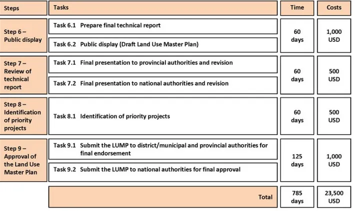
Task 6.1 Prepare Final Technical Report 112 Task 6.2 Public Display (Draft Land Use Master Plan) 112
Step
7
Review
of
technical
report
114
Task 7.1 Final presentation to provincial authorities and revision 114 Task 7.2 Final presentation to national authorities and revision 114
Step 8
Identification of priority projects
116
Task 8.1 Identify and prioritize projects based on the Strategy Matrix 116
Step 9
Approval of the Land Use Master Plan
117
Task 9.1 Submit the LUMP to district/municipal and provincial authorities for final
endorsement 117
Task 9.2 Submit the LUMP to national authorities for final approval 117
PART B
Elaboration and Approval of the Land Use Plan (LUP)
119
Step 1
Preparations and launch of the district/municipal land use
planning
process
121
Task 1.1 Scoping and inception of the Land Use Plan 121 Task 1.2 Dissemination and gathering of stakeholders in 5th Spatial Planning
Stakeholder Forum 122
Step 2
Data collection and data management
123
Task 2.1 Data and information collection 123
Step
3
Data
analysis
124
Task 3.1 Improve geographic attributes of land use units 124 Task 3.2 Analyze existing townscape and building structure 124 Task 3.3 Analyze local tertiary road system (optional) 137
Step
4
Draft
the
Land
Use
Plan
138
Task 4.1 Define future land use type regulations (functional/use-based zoning
ordinance) with District/Municipal LMUP Committee 138 Task 4.2 Define future building regulations (form-based zoning ordinance) with
District/Municipal LMUP Committee 141
Step 5
Review of Draft Land Use Plan by district/municipal stakeholders
149
Task 5.1 Consultation on draft Land Use Plan with Commune/Sangkat authorities 149 Task 5.2 Validate draft Land Use Plan in 6th Spatial Planning Stakeholder Forum 150
Step 6
Public display and endorsement by District/Municipal council
151
Task 6.1 Prepare Final Technical Report 151 Task 6.2 Public Display (Draft Land Use Plan) 151
Step
7
Review
of
technical
report
153
Task 7.1 Final presentation to provincial authorities and revision 153 Task 7.2 Final presentation to national authorities and revision 154
Step 8
Identification of priority projects
155
Step 9
Approval of the Land Use Plan
156
Task 9.1 Submit the LUP to district/municipal and provincial authorities for final
endorsement 156
Task 9.2 Submit the LUP to national authorities for final approval 156
References
158
Annexes
159
Annex 1 List of spatial and non-spatial data required for District/Municipal Land Use
Master Planning and Land Use Planning 159 Annex 2 List of guiding questions for Planning Step 3 (Part A) 166 Annex 3 List of land use regulations for Municipal/District Land Use Plan 168
Annex 4 GPS field sheet 175
Annex 5 Excerpt from a draft Strategy matrix for Future Green System, Environmental Protection and Climate Change Adaptation (2016 - 2035) 176 Annex 6 Outline Structure for a District/Municipal Land Use Master Plan and Land Use
Plan Technical Report 180 Annex 7 Balance of existing and future land use zones in Battambang Municipality 182
l
ist oFM
apsMap 1 Position of Battambang Municipality in Battambang Province Map 2 Administrative structure and boundaries in Battambang Municipality Map 3 Overall territorial zoning in Battambang Municipality
Map 4 Topography and water resources in Bavel District (Battambang Province) Map 5 Topography and water resources in Rolea B’ier District (Kampong Chhnang) Map 6 Bavel District SPOT Image 2010
Map 7 Existing land use categories in Bavel District (Battambang Province) Map 8 Existing land use categories in Battambang Municipality
Map 9 Existing land use categories in Battambang Municipality – Zoom-in/extract showing the level of detail and geographic explicitness
Map 10 Existing land use categories in urban area of Battambang Municipality Map 11 Land use change in Bavel District (Battambang Province)
Map 12 Evolution of built-up area in Battambang Municipality
Map 13 Land tenure formalization in Bavel District (Battambang Province)
Map 14 Existing informal settlements in Ta Khmau Municipality (Kandal Province)
Map 15 Population density by commune in Rolea B’ier District (Kampong Chhnang Province) in 2014
Map 16 Population growth rate by commune in Rolea B’ier District (Kampong Chhnang Province) between 2006 and 2014
Map 17 Net migration rate by Sangkat in Kampong Chhnang Municipality and Roloe B’ier District (Kampong Chhnang Province) between 2006 and 2014
Map 18 Existing public administration and services urban area of Battambang Municipality Map 19 Existing public administration and services in Bavel District (Battambang Province) Map 20 Existing cultural and religious facilities in urban area of Battambang Municipality Map 21 Existing transport infrastructure system in urban area of Battambang Municipality Map 22 Existing transport infrastructure systems in Bavel District (Battambang Province) Map 23 Existing green/blue system in Ta Khmau Municipality (Kandal Province)
Map 24 Existing water supply system in Ta Khmau Municipality (Kandal Province)
Map 25 Existing sewerage and drainage system in Ta Khmau Municipality (Kandal Province) Map 26 Existing solid waste management system in Ta Khmau Municipality (Kandal Province) Map 27 Existing energy supply system in Ta Khmau Municipality (Kandal Province)
Map 28 Existing agricultural water management in Bavel District (Battambang Province) Map 29 Distribution and importance of labor occupation (by key sector and by Sangkat) in Ta
Khmau Municipality (Kandal Province)
Map 30 Distribution of main soil (according to FAO classification) in Rolea B’ier District (Kampong Chhnang Province)
Map 31 Soil fertility in Rolea B’ier District (Kampong Chhnang Province)
Map 32 Projected future population density by Sangkat in Battambang Municipality, in 2020 Map 33 Spatial Development Model for Battambang Municipality
Map 34 Future transport infrastructure system in Battambang Municipality
Map 35 Future transport infrastructure system in Bavel District (Battambang Province) Map 36 Future green/blue system in Battambang Municipality
Map 37 Future green/blue system in urban area of Battambang Municipality Map 38 Future water supply system in Ta Khmau Municipality (Kandal Province) Map 39 Future sewage/drainage system in Ta Khmau Municipality (Kandal Province) Map 40 Future solid waste management in Ta Khmau Municipality (Kandal Province) Map 41 Future energy supply system in Ta Khmau Municipality (Kandal Province)
Map 42 Future public administration and services in urban area of Battambang Municipality Map 43 Future cultural and religious facilities in urban area of Battambang Municipality
Map 44 Future agricultural and environmental management (forest and water) in Bavel District (Battambang Province)
Map 45 Future areas for heritage protection and tourism promotion in Battambang Municipality Map 46 Draft Land Use Master Plan of Ta Khmau Municipality 2035
Map 47 Future development phases of urban expansion in Battambang Municipality
Map 48 Land Use Master Plan Battambang Municipality – Official plan layout with stamps and signatures by higher Government authorities
Map 49 Existing building density (case study areas) in urban area of Battambang Municipality Map 50 Survey map of case study area in Battambang Municipality
Map 51 Existing building height (number of floors) in urban area of Battambang Municipality Map 52 Existing road setbacks in urban area of Battambang Municipality
Map 53 Existing building coverage types in urban area of Battambang Municipality Map 54 Existing heritage buildings in Ta Khmau Municipality (Kandal Province) Map 55 Future Land Use Plan Battambang Municipality (Urban Area)
Map 56 Future mixed use zones in urban area of Battambang Municipality
Map 57 Draft building density regulations (Floor Area Ratio) in urban area of Battambang Municipality
Map 58 Draft building height regulations in urban area of Battambang Municipality Map 59 Draft road setback regulations in urban area of Battambang Municipality
Map 60 Draft building coverage type regulations in urban area of Battambang Municipality
l
ist oFF
iguresFigure 1 Involvement of Stakeholders in District/Municipal Land Use Master Planning and Land Use Planning
Figure 2 Overall planning process of District/Municipal Land Use Master Plan Figure 3 Overall planning process of District/Municipal Land Use Plan
Figure 4 1st Spatial Planning Stakeholder Forum in Ta Khmau Municipality, 2013 Figure 5 Integration of relevant spatial planning data into a spatial planning database Figure 6 Example of meta-database file
Figure 7 Articulation of tasks in Planning Step 3 Situation analysis and envisioning the future Figure 8 Land use mapping workshop in Bavel District, 2011
Figure 9 Field survey and land use reconnaissance associated with GPS Figure 10 Evolution of built-up area in Battambang Municipality
Figure 11 Population number and annual population growth rate in Kampong Chhnang Municipality, 2006-2014
Figure 12 Age pyramid of Kampong Chhnang Municipality population in 1998 (left) and in 2008 (right)
Figure 13 Projection of population development in Battambang Municipality 2007 to 2020 (based on three growth scenarios)
Figure 14 Visualization of ‘Vision 2030’ of Battambang Municipality with six pillars of future development
Figure 15 Articulations of tasks in Planning Step 4 - Develop the draft Land Use Master Plan
Figure 16 Consultative workshop on future transport infrastructure system with Sangkat/Commune Chiefs in Battambang Municipality, 2007
Figure 17 Consultative workshop on future green/blue system with Sangkat/Commune Chiefs in Battambang Municipality, 2007
Figure 18 Building Coverage Ratio (BCR) parameter Figure 19 Floor Area Ratio (FAR) parameter
Figure 20 Building height parameters
Figure 21 Road setback/alignment parameters Figure 22 Building coverage type parameters
Figure 23 Land use regulations (functional/use-based zoning ordinance) for mixed use zones in Battambang Municipality
Figure 24 Consultative workshop with Sangkat Chiefs on land use zoning and regulations, Battambang Municipality 2008
Figure 25 Consultative workshop with Sangkat Chiefs on land use zoning and regulations, Battambang Municipality 2008
l
ist oFt
ablesTable 1 List of potential stakeholders in district/municipal spatial planning Table 2 Land use categories for existing land use mapping
Table 3 Population number, population density, annual population growth rate and net migration rate in Kampong Chhnang Municipality by Sangkat, 2006-2010
Table 4 Population number, family number, and average household size in Kampong Chhnang Municipality by Sangkat, 2006-2010
Table 5 List of public services
Table 6 List of cultural and religious facilities
Table 7 List of typical elements of green/blue system in urban, peri-urban and rural areas Table 8 Subsectors/themes and main issues for analysis of technical infrastructure system Table 9 Main indicators for analysis of current water supply system
Table 10 Main indicators for analysis of current wastewater and drainage system Table 11 Main indicators for analysis of current waste management system Table 12 Main indicators for analysis of current energy supply system
Table 13 Population in 2002-2006 and estimated population in 2020 in Battambang Municipality Table 14 Conversion of population increase into housing land requirements (Land Use Master Plan Battambang Municipality)
Table 15 Long-term development goals and corresponding development objectives in the Draft Land Use Master Plan for Bavel District (Battambang Province)
Table 16 Elements and attributes of a development vision Table 17 Overview of road network hierarchy / road classification Table 18 Major technical infrastructure facilities
Table 19 Demand forecast and gap analysis overview Table 20 Land use types and protection measures
Table 21 Balance of new housing areas and demand for additional housing areas (Land Use Master Plan Battambang Municipality)
Table 22 Overview of average building densities (BCR and FAR) in selected case study areas of Battambang Municipality
Table 23 List comparing draft BCR and FAR regulations for the Land Use Plan Battambang Municipality with national standards from Sub-Decree 42
l
ist oFa
cronyMs CDP Commune Development PlanCDC Council for Development of Cambodia
CEMAT European Conference of Ministers responsible for Spatial/Regional Planning CMDP Community Managed Development Partners (NGO)
CLUP Commune Land Use Plan
CWG Core Working Group (under Municipal Working Group for Land Management and Urban Planning Working Group)
D&D Democratic Development (previously Decentralization and De- concentration) DCLMUP District Committee for Land Management and Urban Planning
DED Deutscher Entwicklungsdienst (German Development Service) DLUMP District Land Use Master Plan
DP Detailed Plan
DSDP District Strategic Development Plan GDP Gross Development Product GIS Geographic Information System
GIZ Deutsche Gesellschaft für Internationale Zusammenarbeit mbH
ISIC International Standard Industrial Classification of All Economic Activities LMUP Land Management and Urban Planning
LMUP-C Land Management and Urban Planning Committee LMUP-WG Land Management and Urban Planning Working Group LUMP Land Use Master Plan
LUMP-LUP Land Use Master Plan and Land Use Plan LRP II Land Rights Program II (by GIZ)
LUP Land Use Plan
M&E Monitoring and Evaluation
MCLMUP Municipal Committee for Land Management and Urban Planning MIP Municipal Investment Program
MLMUPC Ministry of Land Management, Urban Planning and Construction MLUMP Municipal Land Use Master Plan
MoI Ministry of Interior MoP Ministry of Planning
MPLUP Master Plan and Land Use Plan MRC Mekong River Commission
MSDP Municipal Strategic Development Plan MSLWG Municipal State Land Working Group
NCDD National Committee for Sub-National Democratic Development NCLMUP National Committee for Land Management and Urban Planning NGO Non-Governmental Organization
NIS National Institute of Statistics NSDP National Strategic Development Plan OD Operational District
PCLMUP Provincial Committee for Land Management and Urban Planning
PDLMUPC Provincial Department of Land Management, Urban Planning and Construction PES Payment for Environmental Service
PIP Public Investment Program
PPPS Policies, programs, plans and strategies PSLMC Provincial State Land Management Committee
PSP Provincial Spatial Plan
PWG Provincial [Land Management and Urban Planning] Working Group RGC Royal Government of Cambodia
RUPP Royal University of Phnom Penh
SEIA Social and Environmental Impact Assessment SNEC Supreme National Economic Council
SWOT Strengths, Weaknesses, Opportunities and Threats
VGGT Voluntary Guidelines on the Responsible Governance of Tenure of Land, Fisheries and Forests in the Context of National Food Security
o
verview:
D
istrict/M
unicipall
anDu
seM
asterp
lan anDl
anDu
sep
lanType of plan The District/Municipal Land Use Master Plan (LUMP) is a strategic spatial plan. Well-articulated and aligned to the Provincial Spatial Plan, it provides more detailed directions for spatial development. Addition-ally, the District/Municipal Land Use Master Plan provides a preparatory basis for the Municipal Land Use Plan (LUP) and comprehensive Com-mune Land Use Plan (CLUP).
Planning process
Similarly to the provincial spatial planning, the District/Municipal LandUse Master Plan process follows a “Situation-Target-Proposal “ap-proach:
• Situation: Evaluation of the current situation and how it came about;
• Target: Set-up vision, goals and objectives;
• Proposal: Specify a possible route and strategy to the goals and objectives.
The Land Use Plan consists of a comprehensive and regulatory land use zoning that covers the entire area of the district/municipality.
Scope of Plan At district/municipal level, the Land Use Master Plan endeavors to de-termine the specific spatial structure and main functions of the district/ municipality by taking into account its integration into the province and build on the main potentials of the district/municipality. It aims to de-termine a vision and spatial development strategies to guide the physi-cal and functional development of the district/municipality. It defines general land use types differentiated between buildable and control categories. It also specifically addresses future transport and commu-nication networks, physical infrastructures, future pubic administrations and services, public spaces as well as agriculture-forest-water manage-ment in the entire territory.
The Land Use Master Plan serves as a reference for the Land Use Plan. The latter determines a use-based zoning based on the Land Use Master Plan with the corresponding detailed regulations for all types of land use zones. The Land Use Plan also includes building regulations (form-based zoning) such as building coverage ratio, road setbacks and building heights. The plan and its regulatory ordinance is legally binding to the administration and to the citizens.
Time horizon 15 years
Scale 1:50,000 to 1:25,000 for districts 1:25,000 to 1:10,000 for municipalities
Authority and
institutions
The District/Municipal Land Management and Urban Planning Com-mittee (LMUP-C) initiates the planning process under the supervisionof the District/Municipal Council. Very likely, the committee will not be involved technically in the planning process, so a District/Municipal Land Management and Urban Planning Working Group (LMUP-WG) is assigned to work it out. The District/Municipal Council coordinates the whole process, and agrees on a draft Land Use Master Plan and/ or Land Use Plan. It then forwards it to the Provincial Council through the Provincial Committee for Land Management and Urban Planning (PCLMUP) for consent. After this twofold agreement process, the plan is submitted to the National Committee for Land Manage-ment and Urban Planning Committee (NCLMUP) for final approval (see Figure 1).
Figure 1 Involvement of Stakeholders in District/Municipal Land Use Master Planning and Land Use Planning
Planning Process
The planning procedure to design a Land Use Master Plan comprises a sequence of nine steps that take action over the course of approximately 26 months (see Figure 2). This is an indicative timing, assuming a smooth and un-interrupted planning process, which is in practice rarely the case. The division of the process into nine steps and this indicative timing is based on the Deci-sion on the Detailed Procedure for Development of the Municipal, District and Khan Master Plan and Land Use Plan released by the National Committee for Land Management and Urban Planning (NCLMUP 2013).
Figure 2 Overall planning process of District/Municipal Land Use Master Plan
The planning procedure to design a Land Use Plan also comprises a sequence of nine steps that take action over the course of approximately 22 months (see Figure 3). This division of the process into nine steps is based on the Decision on the Detailed Procedure for Development of the Municipal, District and Khan Master Plan and Land Use Plan released by the National Committee for Land Management and Urban Planning (NCLMUP 2013). However, given the fact that the Land Use Planning Process is based upon and elaborated in continuity with the Land Use Master Plan-ning Process, many activities conducted during this initial process do not need to be reiterated, so that the LUP process is shorter than the LUMP one.
p
art
a
e
laboration
anD
a
pproval
oF
D
istrict
/M
unicipal
l
anD
u
se
M
aster
p
lan
Step 1 PART A Step 2 Step 4 Step 5 Step 3 Step 6 Step 7 Step 8 Step 9
s
tep1 p
reparations anDl
auncH oF tHeD
istrict/M
unicipals
patialp
lanningp
rocessTask 1.1 Scoping and Inception
Overview
During a first discussion at district/municipal level, the main authorities discuss the objectives and scope of the spatial planning process.
Who is involved?
• Initiation
• District/Municipal Council
• District/Municipal Committee for Land Management and Urban Planning
• Provincial Department of Land Management, Urban Planning, Construction and Cadaster (for backstopping)
• Ministry of Land Management, Urban Planning and Construction (for backstopping) • Participants
• District/Municipal Council and Board of Governors • District/Municipal technical line offices
• Representative(s) from other district/municipality where spatial planning was success-fully con-ducted
Activities/methodology
• Introduce spatial planning approach to district/municipal authorities. This
presen-tation should clearly explain the overall objectives and approach of spatial planning and the added value spatial planning brings to the existing planning processes. A resource person (MLMUPC or external) should present a case study of spatial planning conducted in other districts/municipalities.
• Discuss the purpose and benefit of conducting spatial planning. Facilitate a
discus-sion on the benefit of conducting spatial planning in the district/municipality and the overall scope of such a plan. Encourage active participation of all participants and allow sufficient time for debate.
Overall objectives
Before entering into the actual planning process, preconditions have to be set up in order to allow for a smooth and inclusive planning process. The involved authorities need to under-stand and own the planning process to foster cooperation and provide leadership. Operation-al planning agencies need to be in place to conduct the technicOperation-al work. All relevant stake-holders are to be identified and involved from the start to aid data collection and verification as well as the planning and plan im-plementation later on.
Step 1 PART A Step 2 Step 4 Step 5 Step 3 Step 6 Step 7 Step 8 Step 9 Necessary outputs
• District/municipal authorities understand the objectives and overall procedure of spatial plan-ning and give a green light to pursue the process.
• There is an agreement on the planning area covered by the Land Use Master Plan.
• The roles and responsibilities of authorities/agencies in the planning process (commune/ Sangkat, district/municipal, provincial and national levels) are clear and understood.
Task 1.2 Establish the Land Management and Urban Planning Committee
and Working Group
Overview
Following provisions of Sub-Decree No 77 (Royal Government of Cambodia 2013), a Land Man-agement and Urban Planning Committee chaired by the district/municipal governor is established to initiate and coordinate the overall planning process. Each line office will be represented in this committee.
At the working level, an operational Land Management and Urban Planning Working Group (LMUP-WG) is assigned with the mandate to design and carry out the planning process: collection and analysis of all necessary data, maintenance of a spatial planning database, design of maps, elabo-ration of future spatial planning options and drafting of the spatial planning technical report. It is important that the District/Municipal Land Management and Urban Planning Working Group is an interdisciplinary (cross-sector) team. Ideally, the members of the working group are technical staff from the different technical line offices represented in the committee. Optionally, the work-ing group can include members from non-state organizations (private sector, NGOs, etc.).
As there is a wide range of mapping and other detailed technical work, which accrues during the planning process, the District/Municipal LMUP-WG might not technically involve in every detail of the planning process. It has been a practical solution to assign a Core Working Group (CWG), which may comprise also lower level technical staff, in order to provide sufficient time for those tasks. The LMUP-WG in this set-up takes rather an advisory role.
Who is involved?
• Initiation
• District/Municipal Council
• District/Municipal Committee for Land Management and Urban Planning
• Provincial Department of Land Management, Urban Planning, Construction and Cadaster (for backstopping)
• Participants
• District/Municipal Board of Governors • District/Municipal technical line offices
Necessary outputs
• The district/municipal spatial planning agencies are established in clear connection with the sub-national government authorities.
• The District/Municipal Council assigns a District/Municipal Committee for Land Management and Urban Planning based on the provisions of Article 02 of Sub-Decree No 77. The District/ Municipal Governor chairs the committee and its members are representatives from key tech-nical line offices.
as-Step 1 PART A Step 2 Step 4 Step 5 Step 3 Step 6 Step 7 Step 8 Step 9
signed with membership from state and, optionally, from non-state agencies.
• The working group meets on an agreed regular basis in a sufficiently equipped office.
• Optionally, a cross-sector operational Core Working Group could be established to carry out the actual technical work.
Task 1.3 Identification and gathering of stakeholders in 1st Spatial
Planning Stakeholder Forum
Overview
Once the land management and urban planning committee and working group are in place, the different actors with a stake in the planning process are identified and brought together. The ob-jectives and scope of the district/municipal land use master plan will be presented to them and their roles and necessary contributions will be discussed. An initial gathering is organized to dis-cuss the expectations of stakeholders regarding the spatial planning process and the key spatial development issues to be ad-dressed.
Who is involved?
• Initiation
• District/Municipal Council
• District/Municipal Committee for Land Management and Urban Planning • Participants
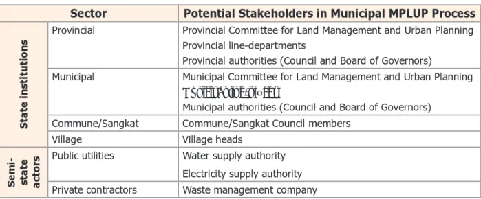
• All stakeholders (Table 1)
Activities/methodology
• Identify all relevant district/municipal spatial planning stakeholders: Facilitate a process (stake-holder mapping or analysis) to identify the actors with a stake in land use management (Table 1 presents a non-exhaustive list of institutions).
Table 1 List of potential stakeholders in district/municipal spatial planning
Sector Potential Stakeholders in Municipal MPLUP Process
State institutions
Provincial Provincial Committee for Land Management and Urban Planning Provincial line-departments
Provincial authorities (Council and Board of Governors)
Municipal Municipal Committee for Land Management and Urban Planning Municipal line-offices
Municipal authorities (Council and Board of Governors) Commune/Sangkat Commune/Sangkat Council members
Village Village heads
Semi- state actors
Public utilities Water supply authority Electricity supply authority Private contractors Waste management company
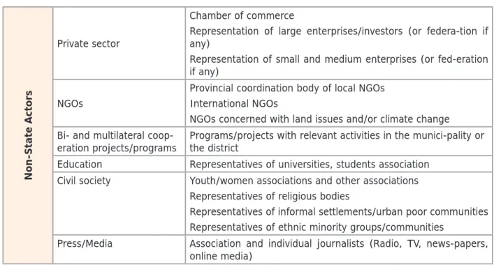
Step 1 PART A Step 2 Step 4 Step 5 Step 3 Step 6 Step 7 Step 8 Step 9 Non-State Actors Private sector Chamber of commerce
Representation of large enterprises/investors (or federa-tion if any)
Representation of small and medium enterprises (or fed-eration if any)
NGOs
Provincial coordination body of local NGOs International NGOs
NGOs concerned with land issues and/or climate change Bi- and multilateral
coop-eration projects/programs Programs/projects with relevant activities in the munici-pality or the district Education Representatives of universities, students association
Civil society Youth/women associations and other associations Representatives of religious bodies
Representatives of informal settlements/urban poor communities Representatives of ethnic minority groups/communities
Press/Media Association and individual journalists (Radio, TV, news-papers, online media)
• Organize a 1st Spatial Planning Stakeholder Forum: With participation from all spatial plan-ning stakeholders identified earlier, facilitate a workshop to introduce the overall objectives, approach of Land Use Master Plan and the expected contributions from different stakeholders. An external resource person can present a case study of land use master planning conducted in other districts/municipalities. Facilitate group work discussions (brainstorming) to discuss expectations of stakeholder towards the process, their readiness to contribute and the main spatial development issues to be addressed.
• Media announcement: announce the spatial planning process, scope and objectives through dif-ferent media (radio and TV broadcasts, newspapers, online media).
Necessary outputs
• Relevant stakeholders for the land use master planning process are identified (stakeholder map-ping).
• Stakeholders are aware of and understand the general spatial planning process.
• Clear commitments from different stakeholders to engage in the process are identified. • Key priority issues to be addressed in the District/Municipal Land Use Master Plan are mapped
out.
Step 1 PART A Step 2 Step 4 Step 5 Step 3 Step 6 Step 7 Step 8 Step 9
Task 1.4 Capacity development needs assessment, team building and
work
planning
Overview
A team-building workshop is conducted with all members of the District/Municipal Land Manage-ment and Urban Planning Working Group with the objective to explain in detail the scope and procedure of the district/municipal land use master planning process. This includes a discussion about roles and tasks of each member and a capacity development need assessment discussed amongst all members.
Who is involved?
• District/Municipal Land Management and Urban Planning Committee and Working Group • Provincial Department of Land Management, Urban Planning, Construction and Cadaster (for
backstopping)
Activities/methodology
• Present detailed Land Use Master Plan procedures: Give a detailed presentation on the
land use master planning procedure to all members of both committee and working group and facilitate a discussion on roles and responsibilities as well as modes of work (team building).
• Work plan and roles/rsponsibilities: Facilitate discussion and drafting of an overall work
plan with a first time schedule and clear roles and responsibilities.
• Training needs assessment: Conduct an assessment of existing skills and needs among
the mem-bers of the LMUP Working Group for further capacity development.
• Introductory training: Identify trainers and deliver introductory training on spatial planning
to the members of the LMUP Working Group.
Necessary outputs
• Scope and procedures of the District/Municipal Land Use Master Plan are agreed upon. • The LMUP Working Group works according to work plans elaborated and agreed by all team
mem-bers.
• Roles and responsibilities amongst members of the LMUP Working Group are identified and assigned according to existing skills.
• Based on the identified needs, a capacity development curriculum is developed for the differ-ent members of the LMUP Working Group.
• Based on this training curriculum, the LUMP Working Group identifies training resources (re-source persons, support budget, etc.).
Step 1 PART A Step 2 Step 4 Step 5 Step 3 Step 6 Step 7 Step 8 Step 9
s
tep2 D
atac
ollection anDD
ataM
anageMentTask 2.1 Data and information collection
Overview
The process starts with a compilation of all existing data relevant to spatial planning of the con-cerned territory. Data are collected from different sectors, compiled, verified and consolidated. It is particularly important to mobilize all district/municipal line offices at this stage.
Who is involved?
• Initiation and implementation
• District/Municipal Land Management and Urban Planning Working Group • Database/GIS expert
• People consulted
• Stakeholders (Table 1)
Activities/methodology
• Collect secondary data: The data collection is organized according to a data requirement list that provides an overview of the data needed for the Land Use Master Plan (see Annex 1). A preliminary compilation of secondary data can be done by using open access data repository (identified in Annex 1). In order to capture data that might not be retrieved in the open access repositories, a complementary process of data collection should be initiated with each provin-cial and district/municipal technical line office and relevant non-state actors. Each member of the working group should be responsible for data collection within his/her own institution. It is highly recommended to collect time-series data in order to allow for later trend/evolution analysis. Also, it is important to compile all reports that provide data and information about land use and land management for the district/municipality. These documents are essential to allow for a proper interpretation of the data. All together the datasets shall be organized along the following themes:
• Administration • Physical Environment • Demography
• Settlements and Building Structure • Housing and Sanitation
• Technical Infrastructures • Social Infrastructures • Land Use and Land Tenure • Environmental Profile
Overall objectives
In a first step along the planning process, a relevant summary of spatial information, facts and figures needs to be compiled. This information, which forms the main basis for analysis, is derived from either existing documents (secondary data, such as statistics from ministries, international organizations, national or local NGOs) or is directly generated by the working group (primary data). The different datasets are then integrated in a geo-database that will support further analyses and mapping endeavors.
Step 1 PART A Step 2 Step 4 Step 5 Step 3 Step 6 Step 7 Step 8 Step 9 • Economy
• Data collection workshop and/or meetings with line offices: The data collected until then may be incomplete, inaccurate or outdated. Against the list of required data, identify gaps in the data base and organize a data collection workshop with all stakeholders who potentially could provide missing data. Alternatively, the LMUP Working Group can organize a series of one-on-one meetings with line offices or non-state actors to organize this complementary data collec-tion. Based on the workshop, the database is consolidated, upgraded and updated.
• Additional [primary] data collection surveys: In certain instances and for specific sectors/ themes, the LMUP Working Group might conduct tailor-made surveys to find out specific infor-mation about e.g. land use/cover, road system, technical and social infrastructure, building structure, traffic information etc.. Primary data collection by the Working Group will require additional time and extra costs.
Necessary outputs
• A preliminary dataset is established with a clear structure and including all data relevant for the spatial planning process.
Task 2.2
Geo-Database management
Overview
Multi-sector datasets collected during Task 2.1 are geo-referenced and integrated in a multi-sector spatial planning database
Who is involved?
• Initiation and implementation
• District/Municipal Land Management and Urban Planning Working Group • Database/GIS expert
Activities/methodology
Geo-database management: Identify a clear spatial database structure; the overall scope of it has to be established with clear themes and sections (see Annex 1). It is important to take this task seriously, as it is a foundation for the entire planning process.
Integrate all data in a structured spatial planning database system, so all data can be represented on a map. This integration requires specific data manipulations depending on the format of data to be entered into the database (see Figure 5). Geo-data are data with specific geo-referenced attributes so that they can be represented and combined (layered) with others on a map. In ad-dition to these geo-data, there are a number of data relevant to spatial planning which do not necessarily have spatial attributes but which can be represented on maps:
• Geo-data existing as vector data with features represented as point, line or polygon; • Geo-data existing as raster data in which the features are represented in a grid of pixels; • Maps that are available only in hard copy documents can be scanned and integrated by
geo-referencing in a Geographic Information System;
• Statistics available for specific administrative units (commune/Sangkat, village) can be linked/ joined to existing administrative geo-data and then be represented;
• Secondary GPS survey data with coordinates of X-Y data can be entered in the system and used to generate geo-data.
Step 1 PART A Step 2 Step 4 Step 5 Step 3 Step 6 Step 7 Step 8 Step 9
Figure 5 Integration of relevant spatial planning data into a spatial planning database
Checking quality, consistency and completeness of all data is important, and there is a need to ensure that the coordinate system is the same for all data of the spatial database in terms of projection and datum. In this regard, it is recommended to use the following coordinate system for all spatial data: Ellipsoid: Everest 1831, Projection: UTM, Horizontal Datum: wgs84. For each data in the database, a clear meta-database file should be created with complete description of data (sector, detail, type, update, source, etc.) (see Figure 6).
Figure 6 Example of meta-database file Necessary outputs
• A preliminary computerized spatial database with a clear structure and meta-database, in-cluding all data relevant for the spatial planning process is established.
Geo-data: vector (point, line, polygon) Geo-data: raster (aerial photos, satellite images...)
Statistics (report from government line agencies, commune database, census database…)
Maps in hard copy documents GPS points
Spatial Planning Database (Geographic Information
Step 1 PART A Step 2 Step 4 Step 5 Step 3 Step 6 Step 7 Step 8 Step 9
s
tep3 s
ituationa
nalysis anDe
nvisioning tHeF
utureOverall objectives
The actual situation of the territory and the current land use are to be considered as a ba-sis for spatial planning. The situation analyba-sis includes a systematic review of strengths and weaknesses of a large diversity of sectors and thematic fields. It also offers an opportunity to discuss needs, potentials, opportunities and threats for further improvement.
Primary and secondary datasets are mapped and analyzed with both sector and cross-sector perspectives. A ‘dynamic analysis’ is undertaken to determine how spatial patterns and land use have been changing over time and are likely to change in the future. It is combined with a ‘static analysis’ aiming to examine in detail what the current land management challenges and potentials are.
After the diagnosis of the past and current land management situation, the spatial plan-ning process now enters a prognosis phase that will engage the stakeholders in a discussion about the development of the district/municipality in future. In a view to anticipate needs and requirements of the population, the prognosis starts with a discussion on the possible future development scenarios related to demography, environment management, settlement and economic development. Combined with the results of the situation analysis, this sets the stage for formulating comprehensive long-term development goals and a vision, which captures and synthesizes these goals. The articulation of the different tasks in Step 3 is pre-sented in Figure 7.
Step 1 PART A Step 2 Step 4 Step 5 Step 3 Step 6 Step 7 Step 8 Step 9
Step 1 PART A Step 2 Step 4 Step 5 Step 3 Step 6 Step 7 Step 8 Step 9
Step 1 PART A Step 2 Step 4 Step 5 Step 3 Step 6 Step 7 Step 8 Step 9
Task 3.1 Data analysis and maps production
Overview
At this stage, data will be analyzed to understand the current patterns (static analysis) and trends (dynamic analysis) of parameters/indicators that are relevant to the spatial development of the district/municipality. Sector and thematic maps will be prepared to support these analyses and represent the results with geographic attributes. These maps will be key resource documents for further planning tasks. The analysis covers the entire territory of the district or the municipality but takes into account the specificities of rural and urban areas as well as the peri-urban interface. The process of data analysis, sketched in Figure 7, systematically addresses and emphasizes the linkages between rural and urban areas (flows of people and resources along communication ways).
Who is involved?
• District/Municipal Land Management and Urban Planning Working Group • Advisor(s) (if available and relevant)
• Database/GIS expert
Activities/methodology
• Organize data analysis and mapping sessions. In order to conduct the data analysis working sessions need to be organized on a regular basis with specific assignments given to different members of the working group according to their expertise and skills. It is recommended to combine ‘static’ (at a given time) and ‘dynamic’ (over time) analyses. In a parallel process, mapping sessions (assisted with computerized GIS) are organized to spatially represent the results of data analysis or to conduct spatial analysis. Data analyses and mapping sessions should be corresponding, as results will be closely interrelated.
• To enable the LMUP working group in this rather complex task, the handbook suggests a guideline for data analysis and map production below, including key points and questions that need to be addressed during the analytical work. Specific examples are given from spatial planning processes in Battambang Municipality and Bavel District (Battambang Province), Kampong Chhnang Munici-pality and Rolea B’ier District (Kampong Chhnang Province) and Ta Khmau Municipality (Kandal Province).
Necessary outputs
• A complete set of sector and thematic maps (if necessary supplemented by graphs, tables etc.) is produced along the guideline, detailing all analyses and studies that are necessary in the master planning exercise.
• Each map and graph/table etc. is accompanied by a short text that describes and explains the main information presented on the maps and their relevance to the spatial development of the district/municipality.
A guideline for data analysis and maps production
The following is meant as a guideline to help the working group is carrying out the different types of analyses and producing the corresponding maps needed. As an additional support, a list of guiding questions is proposed in Annex 2. The specificity of the approach is to distinguish rural from urban and peri-urban areas so to look carefully at the ecological, social and infrastructural connectivity between both areas.
The guideline details the outputs under 16 different sectors/thematic fields that are either manda-tory based on the Detailed Procedure for Development of the Municipal, District and Khan Master
Step 1 PART A Step 2 Step 4 Step 5 Step 3 Step 6 Step 7 Step 8 Step 9
Plan and Land Use Plan (NCLMUP 2013) or optional but recommended during the process.
3.1.1 Position and integration of district/municipality in province/region (mandatory)
Analysis of the position and integration of the district/municipality in the wider provincial or re-gional territory:
• Scrutinize the connectivity of the district/municipal centre with other surrounding growth cen-tres in terms of transport, flow of goods and people (see Map 1);
• Determine the contributions and roles of the district/municipality in the province/region in terms of urban centres hierarchy, population growth, regional connectivity of technical infra-structure, key economic assets and potentials, investment competitiveness, etc.;
• If existing, scrutinize higher-level plans (in particular the Provincial Spatial Plan) and examine their specifications and recommendations for the district or municipal development.
Map 1 Position of Battambang Municipality in Battambang Province 3.1.2 Administrative structure and boundaries (mandatory)
• Establish the administrative divisions of the district or municipality. The analysis should focus on existing inconsistencies and need for clarification regarding commune/Sangkat (and village if relevant) boundaries and respective population affiliations (see Map 2);
• If necessary, organize a consultative workshop and field visit with commune/Sangkat/village authorities and rectify boundaries accordingly;
Step 1 PART A Step 2 Step 4 Step 5 Step 3 Step 6 Step 7 Step 8 Step 9
Khmer name into English.
Map 2 Administrative structure and boundaries in Battambang Municipality
3.1.3 Spatial structure and overall territorial urban/peri-urban/rural zoning (recommended)
• Establish an overall zoning of the district/municipal territory into three main ensembles: ur-ban, peri-urban and rural. Operating a distinction between these three zones is important to focus sub-sequent analysis and planning measures into specific directions, while considering the interactions and balance between the three zones.
• The National Institute of Statistics (2012) reclassified the urban areas in Cambodia based on the following criteria:
• All Sangkat belonging to Krong/Municipalities as established in the Sub-Decree No 18 (Royal Government of Cambodia 2008).
• Any additional commune that fill all following criteria: Total population more than 2,000 people;
Population density higher than 200 people/km²;
Percentage of employment in agriculture (male and female) less than 50%.
• Any other commune recommended by the director of the provincial department of plan-ning. Based on this classification, there are currently 289 communes classified as urban in Cambodia.
• This classification set by the National Institute of Statistics is not entirely satisfactory for land use master planning purposes because the information is aggregated at commune/Sangkat level and does not allow for a more fine-grained spatial differentiation. There are two ways to address this constraint:
bounda-Step 1 PART A Step 2 Step 4 Step 5 Step 3 Step 6 Step 7 Step 8 Step 9
ries are available. The establishment of village boundaries is required in the land titling efforts so cooperation with the cadastral team can help to address this constraint. • Another way is to determine other classification criteria, according to
[non-administra-tive] urban structure parameters such as building density, ground coverage ratio etc. An example of such classification is given in the Battambang municipal land use master plan where a distinction between the three zones was conducted based on average Building Coverage Ratio (BCR): urban > 25%, peri-urban 15-25% and rural < 15%) (see Map 3). • In both cases, it is useful to identify and characterize a peri-urban zone conceived as an
extension of the main urban area (result of an urban sprawl) becoming a transition area between the core urban and the rural hinterlands zone of the district/municipality.
Map 3 Overall territorial zoning in Battambang Municipality 3.1.4 Bio-physical environment (recommended)
The socio-economic system of land use is embedded in the biophysical environment which struc-tures the territory and constrains/enables land-based production activities as well as the shape and location of built-up structures. Hence, it is central to understand how these bio-physical struc-turing elements shape the territory being examined for land use planning purposes.
A watershed analysis that combines the analysis and mapping of topography and water resources is a useful entry into the biophysical environment. First focus is a description of the topography. Second focus is the access to and use of water, as it is essential to support life, the development of agriculture and ensures the transport of people and goods. The watershed analysis aims to examine the relation between topography and water while considering the following aspects: • Identify the main landforms where relief and slope present relatively uniform patterns (see
Map 4);
Step 1 PART A Step 2 Step 4 Step 5 Step 3 Step 6 Step 7 Step 8 Step 9 district/municipality;
• Get a sense of the potential up-stream / down-stream water management issues with a par-ticular attention to the connectivity between urban and rural areas through waterways. • Identify the main sources of water for human consumption and for agriculture (springs, ponds/
lakes, rivers/streams);
• Identify eventual flood patterns (location and magnitude) and identify the settlements or ag-ricultural areas that are flood prone (see Map 5).
Step 1 PART A Step 2 Step 4 Step 5 Step 3 Step 6 Step 7 Step 8 Step 9
Map 5 Topography and water resources in Rolea B’ier District (Kampong Chhnang) 3.1.5 Existing land use (mandatory)
The identification, mapping and analysis of current land use is central to the land use master planning process. At this stage, the working group shall identify and map the different categories of land use based on a classification and symbology which will facilitate the sub-sequent defini-tion of ‘buildable areas’ and ‘control areas’ specified in the Detailed Procedure for Development of Municipal, District and Khan Land Use Master Plan (NCLMUP 2013) and the land use zoning foreseen in the Sub-Decree No 42 on Urbanization of the Capital, Municipalities and Towns (Royal Government of Cambodia 2015). It is useful to distinguish two ensembles of land use categories: built-up (‘buildable’) areas and open spaces (‘control areas’). For each ensemble, two levels of classification (general and specific) might be envisaged (see Table 2). For a comprehensive list and detailed definitions of land use categories, see Annex 6.
Step 1 PART A Step 2 Step 4 Step 5 Step 3 Step 6 Step 7 Step 8 Step 9
Table 2 Land use categories for existing land use mapping
In line with these references, the identification and mapping of land use shall be carried out in two Steps:
• The interpretation of recent remote-sensing images (aerial photo or satellite image) (see Map 6) is instrumental to produce a first draft land use map. However, there are two constraints associated with this initiative. First, recent high-resolution images are not necessarily easy
Built-Up (‘Buildable’) Areas General Specific Residential Detached low-rise residential
Attached low-rise residential Medium-rise residential High-rise residential Mixed residential Commercial Industrial Industrial Light industrial Mixed use
Public services Health (referral hospital, health center, rehabilitation center, clinic etc.)
Education (university, vocational training center, secondary school, primary school, kindergarten etc.)
Public administration (provincial hall, district/municipal hall, com-mune/Sangkat center, provincial department, etc.)
Other administrative facilities (post office, courthouse, police station, fire brigade etc.) Transportation Railway station, bus terminal,
airport, dry port, harbor etc. Tourism
Public space and
green areas Public park, sports field, sta-dium, swimming pool, etc. Culture and
religion Historical heritage, library, thea-tre, museum, pagoda, mosque, church, temple, cemetery etc.) Residential with
agriculture Technical
infra-structure Freshwater treatment plants, wastewater treatment plants, waste disposal sites, power sta-tions etc.
Military Other Built-Up (‘Buildable’) Ar-eas
Open Space (‘Control’) Areas General Specific Agriculture Rice (1 harvest)
Rice (2 harvests) Chamcar (1 or several harvest)
Rice and Chamcar Perennial crop
Other cropping system Forest Evergreen Semi-evergreen Deciduous Bamboo Shrub land Other Agro-forestry Water resources Ponds - lakes
Streams - rivers Canal - irrigation Wetlands
Step 1 PART A Step 2 Step 4 Step 5 Step 3 Step 6 Step 7 Step 8 Step 9
to access at an affordable price. A way to go around this constraint is to work with Google Earth images that are available free of charge on the internet. Secondly, the classification and interpretation of remote-sensing images requires technical expertise, which is not necessarily available within the working group. If necessary, this work could be outsourced to third parties (university, private companies, etc.).
Map 6 Bavel District SPOT Image 2010
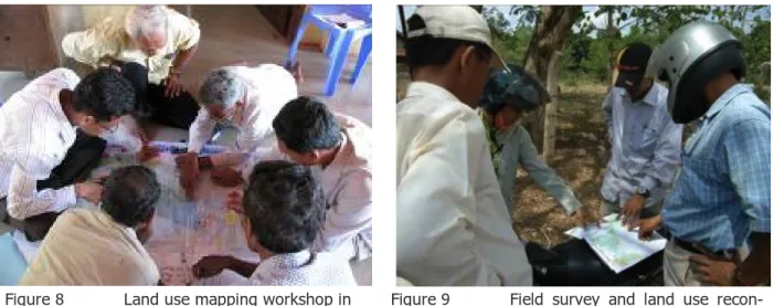
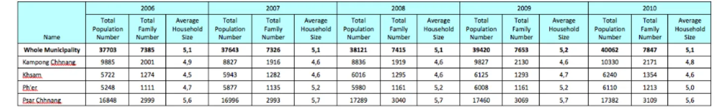
• A complete interpretation of the image will not be possible without conducting additional field surveys and consultation with land users. Field surveys assisted with GPS can help comple-ment land use classification established previously but these additional surveys need to be or-ganized in a consistent and systematic manner (see Figure 8). To this end, it is recommended to use a pre-defined list of land use features/milestones to be recorded with GPS (see Figure 9) (as given in Annex 3). Additionally, consultation with local authorities and land users is necessary to clarify the actual land use. In case of important missing information, land use mapping workshop(s) at local level might be needed.
Step 1 PART A Step 2 Step 4 Step 5 Step 3 Step 6 Step 7 Step 8 Step 9
Figure 8 Land use mapping workshop in
Bavel District, 2011 Figure 9 naissance associated with GPSField survey and land use
recon-The results are displayed on a map (see Maps 7 and 8) and the area sizes of each land use cat-egory are computed in a table or diagram. This will constitute the baseline situation against which the future land use options will be compared.
Step 1 PART A Step 2 Step 4 Step 5 Step 3 Step 6 Step 7 Step 8 Step 9
Map 8 Existing land use categories in Battambang Municipality
For urban and peri-urban areas it is recommended to map the existing land use as detailed and geographically explicit as possible, as this information will be needed anyway as the base for the legally binding future land use zoning in the Land Use Plan (see Map 9). It may be advised to pre-pare an additional zoom-in map with a bigger scale (1:10,000 or 1:5,000) focusing on the urban area of the district/municipality, to allow better readability of the map (see Map 10).
Step 1 PART A Step 2 Step 4 Step 5 Step 3 Step 6 Step 7 Step 8 Step 9
Map 9 Existing land use categories in Battambang Municipality – Zoom-in/extract showing the level of detail and geographic explicitness
Step 1 PART A Step 2 Step 4 Step 5 Step 3 Step 6 Step 7 Step 8 Step 9
3.1.6 The evolution of land use from the past to the present (mandatory)
The scrutiny of the evolution of land use in the district/municipality conveys information about past dynamics and likely paths of changes in the future. It is thus an important part of the ter-ritorial diagnosis.
To conduct this analysis, the working group needs a collection of time-series maps, aerial photos or satellite images and historical accounts of the changes. If time-series geo-referenced data are available, it is possible to quantify land use changes for the district/municipality as pictured on Map 11 showing the land use change in Bavel District between 2002 and 2010. If a Provincial Spatial Plan exists, the results of the analysis of land use change conducted at district/municipal level are available and shall be used as an additional reference. In rural areas, land use change analysis considers transformations of land cover (e.g. typically deforestation associated with the expansion of agricultural areas) (see Map 11).
Step 1 PART A Step 2 Step 4 Step 5 Step 3 Step 6 Step 7 Step 8 Step 9
Map 11 Land use change in Bavel District (Battambang Province)
In urban areas, aerial photos/satellite images and archive documents from successive adminis-trations (and in particular cadastre administration) allow an understanding of the evolution of built-up (settlement) areas, i.e. land conversion through urban growth against the background of the socio-economic transformations associated with urbanization (see Map 12). Typical examples would be the filling-in of lakes and ponds inside the urban area and conversion to newly build-able land, the conversion of agricultural land at the fringe of the urban area into new settlement expansion (residential, industrial and other uses), and conversion of farmland with road access in the peri-urban area into dispersed new settlement clusters (so-called ‘leapfrog development’).
Step 1 PART A Step 2 Step 4 Step 5 Step 3 Step 6 Step 7 Step 8 Step 9
Map 12 Evolution of built-up area in Battambang Municipality
If time-series of geo-referenced data are available, it is possible to quantify land use changes (i.e. agriculture area to settlement area) for the district/municipality as pictured in Figure 10 showing the dynamic of urban growth in Battambang Municipality between 1907 and 2003.