Université de Montréal
Pure Water in the City
Covering the Reservoirs on Mount Royal
Par
Susan M. Ross
Faculté de l’aménagement
Mémoire présenté à la Faculté des études supérieures en vue de l’obtention du grade de
Maîtrise ès sciences appliquées (M.Sc.A.) en aménagement (option conservation de l’environnement bâti)
Avril, 2002
Université de Montréal Faculté des études supérieures
Ce mémoire intitulé :
Pure Water in the City
Covering the Reservoirs on Mount Royal
Présenté par :
Susan M. Ross
A été évalué par un jury composé des personnes suivantes :
……….. président-rapporteur ……….. directeur de recherche ……….. codirecteur ……….. membre du jury
La question du pourquoi et du comment l’eau a disparue du paysage urbain est explorée dans cette étude des réservoirs à ciel ouvert du système d’approvisionnement en eau potable de la ville de Montréal. Une étude de cas de trois réservoirs, le McTavish (à ciel ouvert de 1856 à 1948), Côte-des-Neiges (de 1893 à 1938) et Vincent d’Indy (de 1915 à 1964), considère comment la forme et la fonction des réservoirs ont changé, alors qu’évoluaient les rapports entre facteurs environnementaux, moyens technologiques et préoccupations sociales dans la ville en croissance. Répondant aux avantages et défis de la topographie urbaine, ces réservoirs ont été construits sur les flancs du mont Royal. Le potentiel offert par ces réservoirs d’élargir le noyau de conservation de la montagne est exploré dans une reconsidération de leur situation dans la ceinture de sites institutionnels qui circonscrivent le cœur de ce principal paysage naturel et culturel de la ville.
Un virage dans les développements de l’aqueduc, passant des questions quantitatives à des questions qualitatives, relié à la montée des perspectives de la santé publique et de l’environnement, était à l’origine du mouvement de couvrir les réservoirs. Toutefois, le coût élevé de la reconstruction des basins en boîtes de béton armé recouvert de pelouse et l’absence de règlements exigeant des toits sur les réservoirs, ont mené à des délais de plusieurs décennies. Par ailleurs, dans la ville en pleine expansion, l’augmentation de la capacité de stockage d’eau demeurait au moins aussi importante que la garantie de la qualité de l’eau. L’éthique d’efficacité qui en résulta est traduite dans les paysages des réservoirs transformés, pour lesquels les fonds et l’aménagement furent négligeables.
Des conséquences imprévues mais cruciales de cette transformation sont examinées : la dissociation de l’approvisionnement d’eau de l’écosystème urbain; la perte de visibilité de l’aqueduc; la reconnaissance réduite de sa valeur collective; la responsabilité ambiguë de ces espaces ouverts et, comme conséquence, un manque d’entretien; la dissimulation de l’aqueduc et d’autres fonctions techniques dans le paysage de la montagne et le manque d’intégration des réservoirs dans les plans de conservation de la montagne.
SUMMARY
The questions of how and why water has disappeared in the urban landscape are explored in this study of the uncovered reservoirs of the Montreal water supply system that were destined to be covered. A case study of three reservoirs, the McTavish (open from 1856 to 1948), the Côte-des-Neiges (from 1893 to 1938), and the Vincent d’Indy (from 1915 to 1964), considers how the form and function of these reservoirs changed, as the relationship between environmental factors, technological means and social concerns evolved in the developing city. In response to advantages and challenges of the city’s topography, the reservoirs were built on the flanks of Mount Royal. The potential the reservoirs offer to expand the mountain’s conservation core is explored in a reconsideration of their situation within a belt of institutional properties that delimit the heart of this principal natural and cultural landscape of the city.
A shift in the focus of water supply development from quantitative to qualitative concerns, related to the rise of both public health and environmental perspectives, was a principal incentive to covering water supply reservoirs. Nevertheless, the expense of rebuilding the basins as reinforced concrete boxes covered in earth and sod, and the lack of regulations requiring covers on all reservoirs, lead to the process being delayed for decades. Furthermore, the city was in full expansion throughout this period, so that the pressure to increase the capacity of water storage rivalled that of guaranteeing water quality. The resulting focus on efficiency is embodied in the landscapes of the transformed reservoirs, in which little funds or planning resources were invested.
Certain unplanned but critical consequences of this transformation are examined: the disassociation of water supply from the urban ecosystem; the loss of visibility of the waterworks; the decreased recognition of their collective value; the confusion about responsibility for these open spaces and a related lack of upkeep; the concealment of water supply and other technological functions in the mountain landscape; and the lack of integration of the reservoir sites in plans for the mountain’s conservation.
Key words: Water supply reservoirs-History-Conservation-Mount Royal-Landscape
TABLE OF CONTENTS
SUMMARY/ RÉSUMÉ i
TABLE OF CONTENTS iii
LIST OF TABLES vi
LIST OF FIGURES vii
LIST OF ABBREVIATIONS ix
ACKNOWLEDGEMENTS x
INTRODUCTION 1
CHAPTER I The landscape of water supply 5
1.1 Literature review 5
1.1.1 The landscape perspective in histories of urban water supply 5 1.1.2 The evolving place of water in the industrialised city 10 1.1.3 The waterworks as a heritage and planning issue 12 1.2 Environmental, technological and social perspectives 15 1.2.1 The evolving roles of natural sources and topography in water supply 15
Sources and topography in the Montreal waterworks 18 1.2.2 Water supply in relation to technological developments 21
Technological developments in the Montreal waterworks 24 1.2.3 Water supply in relation to social ideals and power 26 Social ideals and power in the Montreal waterworks 29 1.3 Three Mount Royal reservoirs: the evolution of a water supply landscape 31
1.4 Research questions, hypothesis and methodology 33
Background work for further heritage studies on the waterworks 35
CHAPTER II The evolution of the Mount Royal reservoirs 38
2.1 The situation of the reservoirs within the water supply system,
the mountain landscape and the city as a whole 38
2.1.1 The form of the reservoirs in the urban landscape 44
How the form of the reservoirs has evolved 44
2.2 The history of the evolving form and function of the Mount Royal reservoirs 50 2.2.1 The construction of open basin reservoirs from 1848 to 1915 53
A. The Montreal Water Works Reservoirs: 53
Coteau-Baron, McTavish & High-Level
B. The Montreal Water and Power Reservoirs: 64
Côte-des-Neiges and Outremont
2.2.2 A turning point: water purification and filtration 68 2.2.3 The covering of the reservoirs from 1938 to 1964 71
Table 2.I Summary of information about the three reservoirs 79
CHAPTER III Why the reservoirs were covered 80
3.1 Covered reservoirs in Constantinople and Paris- but not in North America 82 3.2 Reasons given for covering the Montreal reservoirs 85 3.3 An analysis of the reasons, factors and means for covering the reservoirs 93
Environmental factors 94
Technological means 96
Social concerns 98
Missing in the discussion: the role of the mountain 100
Table 3.I Summary of reasons for covering the reservoirs 102
CHAPTER IV Materials, costs & delays
the creation of a controlled landscape for pure water 104
4.1 The complete isolation of treated water from the environment 105 4.2 A burial in modern materials: reinforced concrete boxes and grass fields 105 4.3 Delays and the lack of standards for existing reservoirs 109 4.4 The bottom line of costs and the vagueness of quantities 111
CHAPTER V The unplanned consequences of covering of reservoirs 113
5.1 The loss of water in the urban landscape 113
5.2 Less visibility for the waterworks themselves 120
Tangled responsibilities 124
5.3 The unresolved presence of the waterworks in the mountain landscape 129 5.4 The potential of the reservoir sites in plans for the mountain’s conservation:
making technology a more transparent, congruent part of the landscape. 134
BIBLIOGRAPHY 147
APPENDIX 1 Illustrations I
APPENDIX 2 Selection of quotations concerning
the reasons for covering water reservoirs XXV
LIST OF TABLES
Table 2.I Summary of facts about the three reservoirs in this study 79 Table 3.I Summary of reasons for covering the reservoirs 102
LIST OF FIGURES
Sources are indicated under the title within the text. All others are by the author.
Figure 1.1 Elevated reservoir (steel tank), 1938 15
Figure 1.2 Surface reservoir (masonry lined basin), New York, 1842 16
Figure 1.3 Diagram of surface reservoir used as an elevated reservoir, 1999 16
Figure 1.4 Diagram of a looped and branching water supply network, 1999 17
Figure 1.5 Longitudinal section of the aqueduct pumping main and tail race, 1854 19 Figure 1.6 The pump and the well, two traditional water supply points, 1936 26
Figure 1.7 The McTavish reservoir (uncovered), 1866 30
Figure 1.8 The McTavish reservoir (covered), 2001 30
Figure 2.1 Section of Montreal water supply system, 1999 39
Figure 2.2 Plan of distribution area(s) of Montreal water supply system, 1999 39 Figure 2.3 Vincent d’Indy reservoir on Mount Royal’s northern flanks, 1999 43
Figure 2.4 Zoning map Ville-Marie District, detail, 1990 43
Figure 2.5 Côte-des-Neiges reservoir from Côte-des-Neiges Road, 2001 45
Figure 2.6 Vincent d’Indy reservoir, 1999 45
Figure 2.7 McTavish reservoir, 2000 45
Figure 2.8 McTavish reservoir site from Dr. Penfield Avenue, 2001 45
Figure 2.9 Vincent d’Indy reservoir from Vincent d’Indy Avenue, 2000 45
Figure 2.10 Côte-des-Neiges reservoir site entrance gate, 2001 47
Figure 2.11 Côte-des-Neiges reservoir exposed concrete wall, 2000 47
Figure 2.12 Côte-des-Neiges reservoir stone-faced wall, 2001 47
Figure 2.13 Côte-des-Neiges pumping station, 2001 47
Figure 2.14 Vincent d’Indy valve station, 2001 47
Figure 2.15 Saint-Louis Square with reservoir basin, ca. 1895 54
Figure 2.16 Plan of Saint-Louis Square with old reservoir basin, detail, 1990 54
Figure 2.17 New City Water Works, detail, 1854 56
Figure 2.18 Section of distributing reservoir, detail, 1854 56
Figure 2.19 The McTavish reservoir as planned, detail, 1853 57
Figure 2.20 The McTavish reservoir as built, detail, 1865 57
Figure 2.21 “Montreal from Mount Royal,” 1860 58
Figure 2.22 “McTavish Reservoir M.W.W.”, ca.1873 58
Figure 2.23 “Montreal- Réservoir McTavish”, 1899 59
Figure 2.24 “… Proposed Enlargement of the Montreal Water Works…,” 1873 60
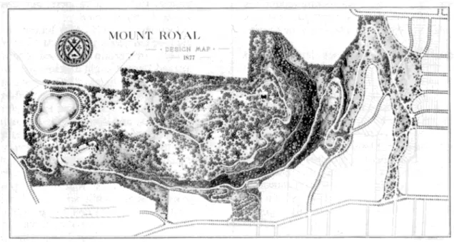
Figure 2.25 “Mount Royal Design Map,” 1877 62
Figure 2.26 Post card view of the High-Level reservoir, ca.1912 63
Figure 2.27 Franchise Territory and System of the Montreal Water and Power Co.,1922 64
Figure 2.28 Montreal Water and Power Company reservoir, 1895 65
Figure 2.29 Outremont reservoir, ca. 1930 67
Figure 2.30 Outremont basin being cleaned, ca. 1951 67
Figure 2.31 Outremont basin being cleaned, ca. 1951 67
Figure 2.32 Atwater filtration plant: Section of filtered water reservoir, 1916 69
Figure 2.33 The McTavish reservoir, 1929 72
Figure 2.34 Côte-des-Neiges reservoir being demolished, 1938 73
Figure 2.35 Côte-des-Neiges reservoir site, 1955 74
Figure 2.36 McTavish reservoir and pumping station, ca. 1937 75
Figure 2.36 McTavish reservoir reconstruction, ca. 1950 76
Figure 3.1 The reservoir of the Atmidan Hippodrome, Constantinople 83
Figure 3.2 Montsouris reservoir under construction, Paris, 1874 83
Figure 3.3 Montmartre multi-storey reservoir, Paris, completed ca.1890 83
Figure 3.4 “Montreal from Mount Royal Park,” ca. 1870 87
Figure 3.6 Outremont basin being cleaned, ca. 1951 92 Figure 4.1 Côte-des-Neiges reservoir and pumping station reconstruction, 1938 107
Figure 4.2 Textbook illustration of a concrete covered reservoir, 1909 107
Figure 4.3 Côte-des-Neiges reservoir site lawn, 2001 108
Figure 5.1 High-Level reservoir, 1885 116
Figure 5.2 “View of the City from the Royal Mount,” 1866 118
Figure 5.3 McTavish reservoir site with cliff face on northwest side, 1999 119 Figure 5.4 Vincent d’Indy reservoir site with cliff face on south side, 2000 119 Figure 5.5 Côte-des-Neiges reservoir site with cliff face on west side, 2001 120 Figure 5.6 Côte-des-Neiges reservoir sign forbidding the public to enter the site, 2000 122
Figure 5.7 Côte-des-Neiges reservoir stonewall ruin, 2001 123
Figure 5.8 Côte-des-Neiges reservoir stonewall ruin, 2001 123
Figure 5.9 Vincent d’Indy reservoir and the Université de Montréal borderline, 1999 124
Figure 5.10 Aerial photograph of Côte-des-Neiges reservoir site, 1971 127
Figure 5.11 Aerial photograph of Côte-des-Neiges reservoir site, 1996 127
Figure 5.12 Côte-des-Neiges public works yard on north half of site, 2001 128
Figure 5.13 Westmount public works yard & (former) snow dump, 2001 128
Figure 5.14 High-Level reservoir, 1878 130
Figure 5.15 Site of High-Level reservoir from Peel Staircase, 2001 130
Figure 5.16 Beaver Lake water supply, Spring 2001 131
Figure 5.17 Côte-des-Neiges reservoir ventilation outlet/ mushroom, 2000 134
Figure 6.1 Mahatma Gandhi Park on top of Châteaufort Reservoir, 2001 141
Figure 6.2 Summit reservoir, pumping station and picnic shelter, 2001 142
APPENDIX I
Figure A.1 Plan of proposed Montreal Waterworks, detail, 1853 II
Figure A.2 Montreal Waterworks system, detail, 1912 III
Figure A.3 Montreal Water Supply systems, detail, 1915 IV
Figure A.4 Montreal Water Supply systems, detail, 1920 V
Figure A.5 Aerial photograph of Montreal above Mount Royal, 1930 VI
Figure A.6 Key diagram of pumping stations and reservoirs
of the Montreal Waterworks, 1937 VII
Figure A.7 Diagram showing the Waterworks System of the City of Montreal, 1945 VIII
Figure A.8 The reservoirs of the Montreal Waterworks, 1959 IX
Figure A.9 Topographical Map of Mount Royal, 1898 X
Figure A.10 Mount Royal Three Summit Concept, detail, 1990 XI
Figure A.11 Map of Mount Royal, 1997 XII
Figure A.12 Plan of McTavish reservoir site (Rutherford Park), 1990 XIII
Figure A.13 Plan of Côte-des-Neiges reservoir site, 1990 XIV
Figure A.14 Plan of Vincent d’Indy reservoir site, 1990 XV
Figure A.15 Plan of McTavish reservoir and conduits, 1970 XVI
Figure A.16 Plan of Côte-des-Neiges reservoir water distribution, 1969 XVII
Figure A.17 Vincent d’Indy reservoir and conduits, 1970 XVIII
Figures A.18-19-20 Post card views of the High-Level reservoir, ca. 1875 to1930 XIX
Figure A.21 Côte-des-Neiges reservoir site, 1915 XX
Figure A.22 Côte-des-Neiges pumping station, Cross section, 1937 XXI
Figure A.23 Plan of Fairmount Park, Philadelphia, 1851 XXII
Figure A.24 Rosehill Reservoir, uncovered, Toronto, 1955 XXIII
LIST OF ABBREVIATIONS
AWWA American Water Works Association
ANQ- Viger Archives Nationales du Québec- Viger Building BAPE Bureau des audiences publiques sur l’environnement BNQ- AF/Holt/ SS Bibliothèque Nationale du Québec
- Aégidius-Fauteux/ Holt/ Saint Sulpice Buildings
CDN Côte-des-Neiges
CCMPBC Comité consultatif de Montréal pour la protection des biens culturels
CUM Communauté Urbaine de Montréal
EP Bibliothèque de l’École Polytechnique de Montréal MU-BL McGill University Library- Blackader-Lauterman
MU-PSE McGill University Library- Physical Sciences and Engineering MU-MR McGill University Library- McLennan-Redpath
MW & P Co. Montreal Water and Power Company
MWW Montreal Water Works
UM-AM Université de Montréal- Bibliothèque d’aménagement UM-LSH Université de Montréal- Bibliothèque des Lettres et Sciences
humaines
USEPA United States Environmental Protection Agency
VDI Vincent d’Indy
VM-GDA Ville de Montréal- Gestion des documents et des archives VM-SHDUM Ville de Montréal- Service de l’habitation et du développpement
urbain
VM-SI Ville de Montréal- Service des immeubles VM-TP Ville de Montréal- Travaux publics
ACKNOWLEDGEMENTS
The research and writing of this mémoire would not have been as enjoyable or worthwhile, without the support of a great many individuals and organisations:
• Sylvia Dowd, who generously lent me the personal papers of her father, Francis V. Dowd, third generation waterworks man, and brought history alive to me through many of her own memories of waterworks related events.
• Dany Fougères, the generous historian of the Montreal waterworks, who helped me to develop my subject, to grasp the archival material involved and not the least, share an unusual passion for the hidden world of urban infrastructure.
• The professors that taught and inspired me in the last three years, in particular Susan Bronson, Michèle Dagenais and Jean-Claude Marsan. Jean-Claude Marsan, my research director, deserves a special remark for his patience, encouragement and faithful belief in me. Together with co-director Peter Jacobs, their constructive comments and questions guided me towards a much clearer path.
• Daniel Chartier of the city’s park services and Michel Gagné of the public works department, who encouraged me to believe that this research would be needed. • My colleagues at Les Amis de la montagne and Le Centre de la montagne, with
whom I explored many other sides of the mountain and shared many enjoyable Smith House lunchtimes after days of solitude in writing. I particularly appreciated being given the opportunity to test my preliminary results in a public conference organised by the Centre.
On a more personal level, there are very many friends on two continents who by sharing my interest in water, in the urban landscape and the history of Montreal, Berlin, and many other cities, inspired me to take this interest seriously. Their influence and encouragement is interwoven throughout the text.
My family has been my most constant and helpful support throughout this adventure. This mémoire is dedicated to the memory of my father Milton John Ross (1929-2001).
This study began as a query about the absence of water in the modern urban landscape, which lead to an investigation into how and why water has disappeared in the city. Current harbour, canal and river rehabilitation projects illustrate a renewed interest in seeing and enjoying water in the city. At the same time, in older cities like Montreal, the dilapidated state of centenary waterworks call for major reinvestment in their upkeep or replacement.1 Altogether it is time to reconsider the impact of industrialisation on the urban landscape, of this period that brought great change in the places and forms of water in the city: as river and lake fronts became docks and harbour fronts, streams and creeks became canals and sewage conduits, and underground pipes that brought water into every house and property replaced the fountains or wells at the centre of public spaces.
Water supply systems represent a particular series of problems and perspectives to reconsider. In contrast with many other functions developed in the industrial era that have lost their importance or original function, the vital role of waterworks for the city has actually intensified. Furthermore, as private wells and smaller separate systems were abandoned, the essential character of the public or municipal system increased. Incorporating constant technological developments, increasing standards and changes of municipal borders, the water supply systems of older larger cities are rarely preserved in earlier historical forms. The forms of the resulting sites illustrate the evolution of the waterworks in relation to the city’s growth.
At the same time, water itself has changed. Once sufficient sources of water for collective supply were found, and productive pumps were put into place to ensure the large quantities of water now required, emphasis shifted to obtaining better water quality. The increased understanding of the relationship between water quality and public health, and eventually that of the environment, lead to standards that seek to control the quality of the
1 The most recent studies suggest $1,6 billion will have to be invested over the next twenty years.
“20 year plan to fix city’s water network,” The Gazette, March 30, 2002, A3; Bureau d’audiences publiques sur l’environnment (BAPE), L’eau, une resource à protéger, à partager et à metre en valeur, Rapport de la
Commission sur la gestion de l’eau, tome II, (Québec: Gouvernement du Québec, 2000), 96-98; Ville de
water produced. In order to meet these standards, the increasingly polluted natural sources of water were filtered and treated in an armada of chemical and mechanical processes. The end result was what we now call “pure” water. But water treatment and quality control were not enough to satisfy the quest for pure water. The focus on purity also had an impact on the presence of water in the landscape. Once water started to be transformed and improved it became important to protect it; water was now an expensive product in itself. The visible presence of pure water in the city disappeared, existing only within the controlled environment of the water supply system.
For a long time the reservoirs of the modern water supply’s distribution system remained a weak link in the effort to control water quality. Before environmental pollution was recognised as a concern, the reservoirs of the older large cities of North America were built as open basins. Often built directly in excavated rock with minimal waterproofing, such reservoirs were as likely to admit ground water and to accumulate rain or snow as to contain treated water intended for consumption. These huge structures were expensive to rebuild as waterproof containers, and so there were long delays before they were finally covered. By covering the open reservoirs, not only was water quality control improved, but the city also lost a visible collective water element as part of its supply system, and a relatively large visible water surface disappeared from the landscape.
This is what happened in Montreal, where three of the city’s covered reservoirs are on sites once occupied by open basins. This study proposes to explore how and why these open reservoirs were covered, in order to understand the factors and reasons that lead to the disappearance of one of the collective forms of water in the urban landscape. Although it is evident that protecting pure water from the dangers of a contaminating environment was critical, it took over fifty years to cover the reservoirs. In the absence of standards or regulation requiring that all open reservoirs be covered, the decision to do so would be based on accumulation of factors that were not all related to water quality.
The reservoirs considered in this study are located on Mount Royal. The mountain is a principal landscape element of the city, whose elevation provided the opportunity to situate the earliest of the city’s major reservoirs above the city, and thus to profit from
gravity for distribution. As the city grew, and moved up the hill and all around the reservoirs, pressures of different kinds lead to the open reservoirs being rebuilt as solid concrete boxes buried under earth and covered in grass. The function of these sites was partly concealed, and the associated pumping stations became the most prominent symbols of the waterworks on the mountain.
In recent times, the battle to conserve the mountain’s natural features has tended to pit nature against the more technological forms of the city’s development. Antennas and automobiles have invaded a protected natural environment, representing the encroachment of the city within the mountain’s green core. The reservoirs are elements of an essential function whose technological development has also had an impact on this environment. Looking at the reservoirs within the mountain landscape challenges us to rethink our relationship to technology in such a context. Covered basins of treated water are one of the particular forms we have given to nature in the city. Through our continued use of the river as source and outlet, the water supply system remains interconnected with the larger eco-system. Looking at the function of the reservoirs within the context of the mountain’s defended landscape could thus help us better understand the dynamic relationship between the environment, technology and society.
The study is divided into five principal parts, which will focus on the development of an approach to the landscape of water supply, a description and history of the Mount Royal reservoirs, an analysis of the reasons why the reservoirs were covered, a brief consideration of factors that had a major impact on their reconstruction, and finally a suggestion of the unplanned consequences of covering the reservoirs on the landscape.
The interest in considering the evolving story of the form and function of the reservoirs on Mount Royal is threefold:
• To explore how our relationship to water has changed in the city. In particular, how the introduction of water quality standards that lead to water being transformed into a product “purer” than the water found in nature itself, may have contributed to the disconnection of nature and the city.
• To help understand the nature of the decisions embedded in the resulting landscape of the waterworks. In particular, how decisions that took place in the shift of emphasis from water quantity to water quality, may have lacked consistent reasoning, but still had important, if unplanned repercussions on the landscape. • To help understand the place of the reservoirs in their actual form in the context of
Mount Royal landscape, and in particular, the potential they might offer to revaluate the relationship between technology and nature in the city.
By linking urban history and urban ecology, it is hoped to strengthen our understanding of the relationship of heritage conservation to natural conservation, and to stimulate our sense of how the strategies of each can work together.
CHAPTER I
The landscape of water supply
Before looking specifically at the Mount Royal reservoirs and how and why their particular landscapes evolved, certain broader questions that are raised by this study should be addressed. How has the landscape perspective been addressed in historical studies of urban water supply? What has been written about how and why the place of water in the city has evolved? What do conservation studies on related subjects suggest are the values particular to waterworks to consider in further planning for these sites?
1. 1 Literature review
Readings of a broad range of texts, intended to help understand these questions, have helped developed the study’s analytical structure. They can be divided into three sections: histories of water supply, works that consider the evolving place of water in the city, and works that help situate the waterworks within conservation studies and planning.
1.1.1 The landscape perspective in histories of urban water supply
Within Montreal, Canadian and larger contexts, the history of urban water supply has only recently begun to be addressed.2 Studies of the built heritage of specific water supply systems are rare. In the Canadian context, the interest of looking at a specific landscape of water supply has been suggested by Steven Mannell’s study of the R.C. Harris Filtration Plant in Toronto, which connects architectural and landscape forms to the engineering process of this major site of Canadian public works history.3 None of the major sites of the Montreal waterworks have been the subject of an equivalent study. Existing studies have mainly considered the architectural character of the pumping stations.4 The urban network that connects and gives meaning to all the pumping stations
2 The first and still the only broad study is Letty Anderson, “Water Supply,” in Building Canada, A History of Public Works, Ed. Norman Ball, (Toronto: Toronto University Press, 1988), 195-220.
3 Steven Mannell, “The Palace of Purification,” Journal of the Society for the Study of Architecture in Canada, 24.3 (1999): 18-26.
4 Giulio Maffini, The McTavish Pumphouse, student paper for “Arch 4”, (Montreal: McGill
and filtration plants is generally neglected. How these sites function as large-scaled engineered landscapes has yet to be explored.
Heather Campbell’s study of the McTavish reservoir site offers a phenomenological interpretation of one of the Montreal’s principal water supply landscapes.5 Her use of cognitive mapping “to reappropriate (sic) … an ambiguous and contradictory site like the Waterworks imposed on the land within a dominant instrumentalism” suggests one approach to dealing with the visible landscape of the waterworks. It also reveals the difficulties of interpreting such a site without sufficient historical documentation.6 In particular, the technical function of the site is misinterpreted, e.g. it is assumed that the reservoir’s original function was a response to epidemics and then suggested that this is somehow obsolete. Recognition that the site’s pumps and reservoirs continue to serve a vital but changed role in the distribution of the city’s water supply is also lacking. Without reference to the long series of changes in form and function to the site over its century and a half history, the attempt to analyse and criticize a suggested technological bias to the site’s development remains instinctive and lacks conviction.
The principal reference for the early history of the Montreal waterworks is Dany Fougères’ recent study of the establishment of the municipal service from 1796 to 1865.7 Demonstrating that the history of the water supply of Montreal is of particular interest because of the precocity of attempts at providing collective supply, and the complexity of the evolving framework of municipal power in relation to the development of public
Atwater de l’aqueduc de Montréal,” “Les stations de pompage de l’aqueduc,” in Montréal: Son histoire,
son architecture, volume 3, (Montréal: La Presse, 1989), 339-386.
5 Heather Robin Campbell, The Montreal McTavish Waterworks, An Accidental Sacred Site,
(Montreal: Concordia University, Department of Art History, Thesis, 1997).
6 Her principal reference for the history of the waterworks is the 5 page history in F. Clifford
Smith, The Montreal Water Works, Its History Compiled from the Year 1800 to 1912, (Montreal: no publisher, April 1913), an important if unreferenced document with information now being verified and revised in current studies. E.g. In Smith’s time, the focus on public health was clear, whereas at the time that the McTavish was first built (1853-56) the focus was on fire-fighting and street cleaning.
7 Dany Fougères, Histoire de la mise en place d’un service urbain public: l’approvisionnement en eau potable à Montréal, 1796-1865, (Montréal: UQAM-INRS Urbanisation, Département d’études
supply, this study presents highly valuable social and technical history, and unearthed archival resources to which this study has referred extensively.
Fougères’ objectives did not however include documenting the related built forms of this period, which include the McTavish reservoir, one of the three this study considers. All the same, many of the themes developed in his analysis, including the importance of the original geographic context of the city, and the challenges of planning within an evolving unplanned context, are critical to developing a framework of this study’s questions about the related landscape.
Le service montréalais -ses composantes, du site de prélèvement de l’eau à la distribution en réseau- devait d’abord épouser et/ou confronter le territoire donné, c’est à dire sa topographie et le potentiel hydrologique qu’il renfermait. Ce territoire constitue la toile de fond sur laquelle le service se déploie et sa principale règle de jeu.8
To Fougères’ demonstration that the early history of the Montreal waterworks is rich in social and technical questions, this study’s questions suggest these early attempts and complex frameworks left a lasting impact on the built environment. The landscape question can help develop an environmental perspective to compliment the social and technological perspectives upon which Fougères’ analysis is built.
Another principal study on the history of the Montreal waterworks is Ginette Gagnon’s enquiry into the period from 1890 to 1914, when the need for water purification was established.9 Her documentation of the rise of emphasis on water purity in relation to public health concerns is of particular interest for this study, as is her account of the developing importance of the perspectives of both hygienists and sanitary engineers within the city’s institutions, and her references to the role of the private water companies that continued to serve parts of the city and its suburbs up until 1927. Her analysis of this critical period in the history of the system’s development suggests that there has generally been a bias in favour of expansion rather than improvements, or an emphasis on
8 Fougères, Histoire, (2001), 46-47.
9 Ginette Gagnon, L’aqueduc de Montréal au tournant du siècle (1890-1914): l’établissement de la purification de l’eau potable, (Montréal: Université de Montréal, Département d’histoire, mémoire,
increasing the quantity of water available (including water storage capacity) even when it was clear that improving water quality was essential for public health.10 The state of disrepair of the existing reservoirs is related to demands for increased capacity.11 The decisions to invest in works that resolved water quality problems only followed a crisis.12
Despite a few other valuable studies on specific periods or perspectives of the history of water supply in Montreal, there remains no complete picture of the system’s physical development as the city grew and technologies and standards evolved.13 There are in fact few all-inclusive studies of the water supply system of individual cities, throughout their history, and including the question of their built form.14 Histories of water supply technologies tend to highlight only a specific period in each city’s history.15 In fact, the combined physical and social contexts of each city are unique enough to have played a significant role in each system’s development. As a result, each city’s system presents a unique landscape of accumulated sites.
Concerned as they are with municipal, technical and public service history, or possibly social geography, historical studies of the water supply of specific cities have not yet
10 Gagnon, L’aqueduc…, (1998), 165. 11 Gagnon, L’aqueduc…, (1998), 18.
12 A crisis/decision cycle is also suggested in Dany Fougères, “Le public et le privé dans la gestion
de l’eau potable à Montréal depuis le XIXe siècle,” in L’eau, l’hygiène publique et les infrastructures, Louise Pothier (dir.), (Montréal: Groupe PGV, collection Mémoires vives, 1996) 47-63.
13 Louise Pothier, “Réseaux d’eau potable et d’eaux usées, l’hygiène publique dans la société
montréalaise (1642-1910)” in L’eau, l’hygiène publique et les infrastructures, Louise Pothier (dir.), (Montréal: Groupe PGV, collection Mémoires vives, 1996) 25-45; Poitras, Claire. “Construire les infrastructures d’approvisionnement en eau en banlieue montréalaise au tournant du XX e siècle; le cas de Saint-Louis.”Revue d’histoire de l’Amérique français 52.4 (printemps 1999): 507-531.
14 Laure Beaumont-Maillet, L’eau à Paris, (Paris: Hazan, 1991) covers the entire history of the
Paris water supply systems, including most of the major sites. More typically, covering only the earlier periods of New York and Philadelphia are Gerard T. Koeppel, Water for Gotham, A History, (Princeton (N.J.), Princeton University Press, 2000) and Tuomi Forrest, Clean Green Machine: Philadelphia’s
Fairmount Water Works, 1800-1860,< http://xroads.virginia.edu/~CAP/WW/home.html>, (22/11/00). 15 Nelson Manfred Blake,Water for the Cities, A History of the Urban Water Supply Problem In the United States,(Syracuse (NY): Syracuse University Press, 1956); F. L. Small, The Influent and the Effluent, The History of Urban Water Supply and Sanitation, (Saskatoon: Modern Press, 1974); Letty
Anderson, “Water Supply,” in Building Canada, A History of Public Works, Ed. Norman Ball, (Toronto: Toronto University Press, 1988) 195-220.
fully engaged the impact of geographic context, the physical patterns and the built forms of water supply.16 But starting at the largest geographic scale, the importance of the development of water supply within a specific physical environment is clear. The history of larger cities often contains the story of parallel systems that would eventually converge as city and suburbs merge.17 Climate, which transforms a city’s hydrological situation throughout the year, is rarely mentioned, except with regards to extreme conditions like the Canadian arctic.18
This very brief overview has shown that the landscape perspective is all but absent from histories of urban water supply, in particular those about Montreal, that have mainly considered social and technological developments. A significant new overview of the history of urban sanitation by Martin V. Melosi, suggests how a third, environmental perspective, should also be considered, a perspective that introduces questions about water supply that reflect both the natural processes it depends on and the evolving relationship of society to the environment.19 The environmental perspective suggests the necessity of seeing the entire sanitation pattern of the city, including water supply, sewages, drainage and waste disposal, as part of the interconnected urban eco-system.
1.1.2 The evolving place of water in the industrialised city
The neglect of the physical landscape of water supply in historical studies is perhaps not so surprising. The water supply system of a large modern city is part of the underground world of urban infrastructure that occupies kilometres of conduits concealed beneath the city’s streets. These underground forms take advantage of the ground as substructure and
16 Paul-André Linteau, Maisonneuve ou comment des promoteurs fabriquent une ville, 1883-1918,
(Montréal: Boréal Express, 1981), 123-146; John Hagopian, “The Political Geography of Water Provision in Paris, Ontario, 1882-1924,” Urban History Review, 23.1 (November 1994): 32-51; Claire Poitras, “Construire les infrastructures…”, (1999): 507-531.
17 W.V. Aird, The Water Supply, Sewerage and Drainage of Sydney, (Sydney: Metropolitan Water
Sewerage and Drainage Board, 1961); Ann Durkin Keating, “Many Systems: Water Provision in Nineteenth Century Chicago,” in Water and the City: The Next Century, Ed. Howard Rosen and Ann Durkin Keating, (Chicago: Public works Historical Society, 1991): 91-104.
18 Letty Anderson, “Water Supply,” (1988), 216.
19 Martin V. Melosi, The Sanitary City, Urban Infrastructure in America from Colonial Times to the Present, (Baltimore: The John Hopkins University Press, 2000).
insulation, and the logic of following the pattern of streets to connect to and serve every property in the city.20
The discreet presence of water supply in the public domain belies the radical transformation of the urban landscape that it brought about. Universal water supply contributed to the disappearance of water itself from the urban landscape. In the modern city water mainly flows below the ground in built forms, alongside storm water and sewage conduits built to canalize creeks and channel away the increasing quantities of water consumed in the industrialised city.21 The advantages of the underground systems are balanced by certain disadvantages: the possibility of pipe breakage in poorly built or maintained roads, the difficulty of detecting and repairing defects, and not the least, the greatly diminished presence of water in the city.
Alongside the physical changes to the urban landscape, the hidden infrastructure of the modern sanitary city introduced the framework for a whole series of changes in the social landscape: from the privatization of water usage to the promotion of a domestic and bodily hygiene ethic.22 These changes are expressed discretely throughout the built landscape in functions that exploit and integrate water supply in every aspect of public life.23 The consequences of the development of modern urban water supply have been profound, transforming our relationship to nature and a whole series of rituals of public and private life. Although water supply systems generally represent the earliest and some of the most important collective municipal investments, practically defining the origins of public works, the human relationship to water has become increasingly private, even hidden, as many water functions disappeared from the public domain.24 Few traces
20 Sabine Barles et André Guillerme, L’urbanisme souterrain, (Vendôme: Collection que-sais-je,
Presses universitaires de France, 1995), 22-23.
21 Anne Whiston Spirn, The Granite Garden, Urban Nature and Human Design, (New York:
Basic Books, 1984), 130.
22 Jean-Pierre Goubert, La conquête de l’eau, L’avènement de la santé à l’âge industriel, (Paris:
Hachette, 1986), 65-96, 171; Ivan Illich, H2O, Les eaux de l’oubli, (Paris: Lieu Commun, 1988 (1985)), 137-145.
23 Asa Briggs, Victorian Cities, (Berkeley, Ca.: University of California Press, 1993 (1963)), 16. 24 Goubert, Conquête, (1986), 77-96.
remain of the celebrations of nature or civic pride once associated with collective fountains, the symbolic expression of deep-rooted social patterns now replaced by the individual domestic equipment that is considered essential to modern standards of living.
One of the consequences of this hidden landscape of water usage is that our perception of the relationship between water supply and the natural water cycle has been dulled.25 Water supply is now part of a completely controlled environment. This can be related to the broader development of controlled climates as an ideal: air-conditioned work and living spaces, interior swimming pools, greenhouses, all emphasize the possibility of overcoming natural climate and conditions. Out of doors, pesticides and machinery make it possible to manicure the landscape as carefully as an interior space. In this context, a perfectly controlled water supply, in terms of taste, smell and temperature, even if it was dependant on chemical treatment, developed as an ideal. That chemicals could be unhealthy was not initially a concern. (Figure A.25, page XXIV in Appendix 1).26
Perhaps in reaction to this controlled relationship to water and nature in general, there is a renewed human need for a relationship to water as part of nature, and the insight that experiencing water in the open environment brings to the meanings of life.27 More recently environmental preoccupations have reawakened public awareness of water as an element of the eco-system, and renewed the potential place for water in the public domain. Once wastewater started to be treated and polluted rivers revived, the potential of recreational water spaces could be rediscovered.28 A renewed interest in finding a place for water in the city has lead to the revitalization of riverfronts, the “daylighting” of covered streams, and the discovery of new uses for disaffected canals and harbour fronts.
25 Michael Hough, City Form and Natural Process, (London: Croom Helm, 1984), 108; Robert L.
Thayer, Gray World, Green Heart, Technology, Nature and the Sustainable Landscape, (New York: John Wiley & Sons, Inc., 1994), 78-79.
26 All figures beginning with A are to be found in Appendix 1. 27 Anne Whiston Spirn, The Granite Garden, (1984), 130.
28 Jean Landry, “Après deux ans: Où en est le projet du Montréal Bleu?” Sur la montagne, Bulletin d’information du Centre de la montagne 12, (Summer 1997): 8-9.
Yet it remains that the water running in the city’s pipes, the result of visionary collective investments in the city’s development has little presence in the public domain.
1.1.3 The waterworks as a heritage and planning issue
The potential value of renewed forms of water in the city should be connected to the roles and meanings that water has had throughout history, as part of the sacred and profane, the domestic, working and social rituals of human life. Water supply has a rich history, in which the value of water as a necessity, a product and a symbol are all present at once. Although the forms have changed, new meanings continue to take their root in a rich heritage of natural and cultural values. Reconnecting the individual experiences of water to the tradition of collective experiences may also help identify the value of public works now taken for granted. It is possible that through lack of recognition, these sites suffer from a lack of maintenance or basic acts of conservation.
In studies of engineering, industrial and urban heritage, the heritage value of the landscape of water supply is beginning to be suggested and remind us of both the civic value of these collective investments and their essential role as support structure for the entire city.29 But the commemoration of water supply as a work of engineering is only one perspective, which emphasises the technological history of its development. Even now obsolete technical systems are the records of the city’s struggles to grow. Older cities reflect how their water supply system developed at a time when the sources and topography in their more natural form played a greater role. The resulting waterworks of the modern system may still embody these earlier situations.
Many systems are only valued as heritage once they are no longer used, and then even more so if they haven’t been too radically changed from their original form. What is the relative value of a system that has changed many times over but continues to serve a city
29 Historic Sites and Monuments Board of Canada, Commemorating Engineering Achievements, Framework document, November 1994; Paul Bernard, Michel Jobin, Nicole Dorion et François Dubé, Bilan du Patrimoine, Transport, communication et services publics: Série 4000 et Fonction commerciale: Série 5000, (Québec: Publications du Québec, 1999) 138-147; Ministère de la culture et de la
communications du Québec et Ville de Montréal, Le patrimoine de Montréal, document de reference, (Montréal: MCCQ/ Ville de Montréal, 1998) 67-69.
in its renewed form? As ongoing functions, public utilities like the waterworks are a living kind of heritage, whose conservation must be integrated into continued planning and development. This continues to be the case today, and as the sites are maintained or even potentially redesigned, their potential to reflect their accumulated heritage should be reconsidered. For one thing, the consequences of the concealment of their function should be taken into account. It has been suggested that some types of infrastructure have greater potential for integration and visibility in the landscape.30 Is there not greater potential for certain sites of the water supply system to be given more intentional visibility, such as the pumping stations, treatment plants and reservoirs, all large sites of valuable city property?
Thayer categorises industrial landscapes in terms of their acceptability: specific types of materials, social or historic associations are more easily accepted.31 One could propose that water supply has the potential to be perceived as a relatively positive technology, not only on the basis of its “purity” associations but also in relation to increased interest in water issues. The functioning sites of the waterworks offer a potential place to make the public aware of how this essential urban technology works.
Understanding the relationship between a city’s unique natural form and the solutions to water supply problems can have benefits for both the city’s form and the system itself, by working with nature instead of against it. The potential for improved urban design through the re-integration the city’s water supply and sewage as part of the natural cycle of water has been suggested.32 But it is a challenge to apply ecological planning theory to existing cities, where the systems were built over decades with increasingly durable materials.
30 Michel Gariépy, “L’analyse du paysage au sein de l’évaluation environnementale ou
l’aménagement à l’ère de la rectitude politique,” in Le paysage territoire d’intentions,dir. Philippe Poulladouec-Gonidec, Michel Gariépy et Bernard Lassus, (Montréal: Éditions Harmattan, 1999), 104; George Farhat, “Paradoxes du paysage infrastructurel.” Les cahiers de la recherché architecturale et
urbaine, Paysages contemporains. Paris: Éditions du patrimoine, (avril 2000), 35-44.
31 Robert L. Thayer, Gray World, Green Heart, Technology, Nature and the Sustainable Landscape, (New York: John Wiley & Sons, Inc., 1994), 54-55, 140-141.
The fact that the waterworks were considered major public works when built was often expressed in the architecture of the related buildings. But the integration of these works of civil engineering of an enormous scale into the city’s pattern of development has had such a lasting impact that we don’t see it.33 In the context of major reinvestment in public infrastructure being called for, the potential value of the landscape associated with these systems deserves to be reconsidered. Mannell suggests that the visible civic role of such public works complexes was, in the context of post war economics and an increasingly production oriented engineering profession, replaced by an “aspiration to invisible omnipresence,” reflected in the increasing use of the name infrastructure.34
1.2 Environmental, technological and social perspectives:
An analytical framework for looking at water supply reservoirs
The preceding readings have helped identify a series of perspectives for this study. The study of the landscape of water supply calls on society to reconsider its basic relationship with the environment, to understand how urban development has transformed natural processes, to recognise the consequences for the visible landscape of one of its most important achievements of engineering and scientific knowledge, and to recall the forms and meanings of social needs and patterns related to water that have evolved throughout urban history. Three categories of ideas emerge, which help form an analytical framework: relating the landscapes of the waterworks to the environment or natural processes, to technological developments and to social ideals. The following section considers the reservoirs from these environmental, technological and social perspectives.
1.2.1 The evolving roles of natural sources and topography in water supply storage
Considering the larger geographic scale of the city and its surrounding water sources, Anderson has categorised Canadian water supply development according to the differences of salt-water cities, lake cities, cities on major and minor rivers. 35 A city’s location with respect to a predominant water source is one of the major determinants of
33 Briggs, Victorian Cities, (1963), 16; Jean-Claude Marsan, Montréal en evolution, 3rd rev. ed.,
(Laval (Québec): Éditions du Méridien, 1994), 283.
34 Mannell, “The Palace of Purification,” (1999): 24. 35 Anderson, “Water Supply,” (1988), 207-216.
its water supply strategy. The initial development of each city’s system thus reflected its physical context. As systems grew and water quality standards increased, technological solutions developed that overcame the challenges of the natural context.
In addition to the type of source, its quantity and position, and the city’s topography all initially had an impact on the varying physical form of development in different contexts.36 Melosi identifies three types of supply that developed as a result of varying combinations of sources and topography: gravity-fed supply, direct pumping and pumping from elevated storage. The storage function in water supply helps improve upon the natural situation. When a source uphill was insufficient to supply the city and the city had to raise its water, it still looked for ways to store the water above the level of the city, to profit from gravity and provide pressure. Storage of water can help solve problems related to both sources and topography. Water storage tanks on a raised structure could compensate by situating the water above the highest functions of smaller cities. (Figure
1.1) As larger quantities of stored water were called for, surface reservoirs were built, a
form of construction that required much larger properties.(Figure 1.2)
Figure 1.1 Elevated reservoir (steel tank), 1938
(Source: W.A. Hardenbergh, Water Supply and Purification, (Scranton, Pa.: International Textbook Company, 1938), 110.)
Figure 1.2 Surface reservoir (masonry lined basin), New York, 1842
(Source: Nathaniel Currier (lithograph), Eno Collection, new York Public Library, reproduced in Gerard T. Koeppel, Water for Gotham, A History, (Princeton (N.J.): Princeton University Press, 2000), 274.)
Figure 1.3 Diagram of surface reservoir used as an elevated reservoir, 1999
(Source: François Brière, Drinking-Water Distribution, Sewage and Rainfall Collection, (Montreal: Polytechnic International Press, 1999), 86.)
In cities with land available at a high enough level near its centre, surface reservoirs would be built on raised terraces. (Figure 1.3) A hybrid of the raised tank and the surface basin, such a situation was considered an unusual advantage, since a more economical surface reservoir could be built and still profit from gravity.
As water supply technology developed, the dependence on natural advantages or ability to overcome disadvantages changed. Stronger pumps and pipes and purification processes overcame problems related to the position of sources. Efficient pumps accelerated the movement of water through the system and storage of water in the
reservoirs became less related to long term security or providing natural pressure, and more to efficient use of the pumps (e.g. at night when power was cheaper) and the quality of the service (e.g. ensuring regular pressure or permitting temporary partial closure of the system to carry out repairs). As pumps became the critical element in ensuring a secure system, the storage of pump fuel became the ultimate reserve in the system.
The adoption of a looped plan, made possible with a dependable battery of pumps and valves, that interconnected parts of the system so that water stored anywhere in the system could be called on in an emergency in any part of the city, served to further diminish the importance of the location of sources. (Figure 1.4)
Figure 1.4 Diagram of (a) looped and (b) branching water supply network, 1999
(Source: François Brière, Drinking-Water Distribution, Sewage and Rainfall Collection, (Montreal: Polytechnic International Press, 1999), 75.)
The location of reservoirs is nevertheless critical to how they function, since they help the system to adapt to the city’s topography. A complex topography would call for multiple reservoirs, positioned in relation to the different parts of the city. Separated pressure zones reduce the area within which pumps and valves work to increase or reduce water flow, breaking down the energy required to reach the highest level, and reducing the work on each level of pumps and valves. Specific reservoirs are then associated with each of these areas.
Sources and topography in the Montreal waterworks
The city of Montreal’s physical context, especially with regards to water sources and topography, had no small part in the resulting form of the system. The city is situated on an island in the St-Lawrence River, a river that has been a major player throughout the city’s development, including as an unusually abundant source. In addition, although modest in size, the mountain called Mount Royal situated at the middle of the city has been a significant structuring element in the development of water distribution strategies.
Initially water was supplied individually or by water carriers from wells and springs as well as streams that ran down from Mount Royal, initially well away to the northwest of the fortified city down by the river. For the average individual citizen, it was more difficult to obtain St-Lawrence River water, especially during the city’s long winter, and it was considered of questionable quality if taken from the shore.37
The first attempts at providing a collective form of water supply (1801-1819) tried to profit from mountain springs and the flow of gravity, but without pumps there was insufficient pressure to raise the water up the promontory on which the city was settled.38 The introduction of pumps made it possible to raise the river’s closer more plentiful water to cisterns situated at the highest level of the city. But as the city grew, the city-side intake, even though situated at some distance from the shore, became too polluted and reservoirs further uphill were required.39
Throughout the earlier period when collective water supply was focussed on the lower city, wells continued to be used in the higher areas. 40 Wells only became obsolete as
37 Fougères, Histoire…, (2001), explains in great detail the variety of ways that water was
supplied, including by water carriers.
38 Fougères, Histoire…, (2001), 271-72.
39 According to Illich, this type of shift, from taking the water from sources in the mountain, to
bringing water from the river up onto the mountain, reflects a problem that has been a part of water supply since the time of the Romans: the disassociation of water from a specific place. Illich, H2O…, (1988), 79.
40 C.L.Cumming, The Artesian Wells of Montreal, (Ottawa: Canada Department of Mines,
Geological Survey 60, Memoir 72, 1915). Many more wells are indicated on the Fortifications Surveys of the city of Montreal of 1866-72.
underground sources proved inadequate or became impure, and supply developed in the highest levels, not until the first quarter of the 20th century. The system that was developed in 1852-56 following the take over of the water works by the city of Montreal in 1845 was only intended to supply the area of the city below Sherbrooke Street.
But the city’s real potential source, from the Great Lakes to the St-Lawrence, was soon recognised as an unusually pure and abundant resource. Furthermore, it was soon realised that the power of this source could be harnessed to raise the water itself.
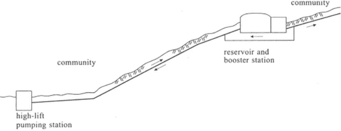
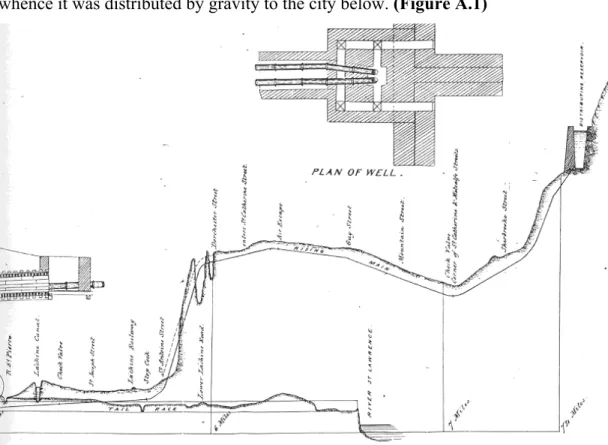
The strength of these advantages is reflected in the fact that the city’s system today is still largely based on the system built in 1853-56 that brought the river’s purer water from above the Lachine Rapids along a canal by gravity to a point to the west of the city, and used water power to raise the supply to reservoirs situated on the mountain’s flanks, whence it was distributed by gravity to the city below. (Figure A.1)
Figure 1.5 Longitudinal section of the aqueduct pumping main and tail race, 1854
(Source: Detail from one of two folded sheets in Comité de l’eau, Rapport du Comité de l’eau, soumettant
les rapports des ingénieurs sur les nouveaux aqueducs de Montréal, (Montréal: John Lovell, 1854),
The proposals and debate around this first most significant and lasting stage in the development of the city’s supply made it clear that both the Saint-Lawrence River and Mount Royal were considered key factors to exploit.41 (Figure 1.5)
As the city developed uphill, and consumption increased, pumps were required to meet demand, but by subdivision of the city into vertical levels, it was still possible to profit from gravity. The fact that the pumps would eventually function on hydro-electricity confirmed the initial recognition that the power of the water could drive the system.
Both the abundance and the purity of the source have been transformed by the gradual transformation of the river into a canal, the poorly controlled consumption of Great Lakes water and the upstream development of industry and cities. Paradoxically, cities with abundant sources, because they are less concerned with wastage, were less motivated to develop efficient or self-cleaning systems. As a result, technical innovation in water supply that considers how to work with the eco-system usually comes from water-poor cities.42 Montreal is an example of such a city, which because it had an abundance of water, wasn’t forced to deal with waste or pollution as quickly as many other large cities.
1.2.2 Water supply storage in relation to technological developments
Two objectives motivated most of the development of water supply technology: increased water quantity (or abundance) and improved water quality (or purity). The quest for abundant and pure water has evolved as the city’s needs grew or changed. In most cities the focus was initially on development of an abundant supply of water. Before the development of equipment that would lead to the current high levels of domestic consumption, the large quantities of water were wanted for fighting fires and cleaning streets. In addition to securing adequate sources, in order to meet the demand, emphasis was placed on the development of the distribution system, including better pumps, stronger pipes, and more or larger reservoirs.
41 Comité de l’eau, Rapport du Comité de l’eau, soumettant les rapports des ingénieurs sur les nouveaux aqueducs de Montréal, (Montréal: John Lovell, 1854), 71.
The reservoir functions can be broadly categorised in relation to either storage (source, time and capacity related) or distribution (or topography related) functions. The storage or reserve function introduces a time factor in the system, ensuring that there is more than enough water in case of a fire or a temporary problem with the main supply, permitting temporary blockages to enable repairs or maintenance, making it possible to limit the use of the supply pumps during the more expensive daytime hours, and providing a way to regulate the difference between supply and demand.43 The amount of time provided corresponds directly to the size or capacity of the reservoirs, but the amount of time required has varied throughout history. In cities with only one source larger quantities of water might be stored.44 In older cities like Rome, London and Paris, multiple reservoirs generally corresponded to multiple sources brought to the city from different directions for reasons of variable topography, the unequal development of parts of the city, the development of parallel water companies or the inadequacy of any particular source.
As cities grew and sources became more polluted, and the understanding of the relationship between disease and water developed, the focus shifted to the purity of water. Universal distribution and the development of sanitation equipment greatly increased the demand for water, but the increased effluent contributed to polluting the sources. This lead to a search for purer sources, located further and further away from the city, and to the construction of water treatment plants. As the understanding of industrial pollution developed, standards at the plants were constantly changed. Concern for water quality slowly shifted to the whole environment, the treatment of the city’s effluent also became a priority, and sewage plants were built to treat used water.45
The modern water supply system is thus the result of an accumulation of developments: expansion, improvement and replacement. Water is now a product of technological
43 Public Works Department, Montreal Waterworks, (Montreal: Public Works Department, 1959),
20; Ville de Montréal, L’eau une source …, (1999), 6-7, 17-18.
44 Leveson Francis Vernon-Harcourt, Sanitary Engineering with Respect to Water-Supply and Sewage Disposal, (London: Longmans, Green, and Co., 1907), 209.
processes, a product whose abundance is ensured by efficient pumps, and purity by laboratory controls. But no matter how modern the standards are that we apply to water supply today, it remains that the systems were built over a period of time that saw an evolution in standards and technology, so that in older cities, the systems in place today are generally an accumulation of historical choices, choices that remain embedded in the resulting landscape.
Melosi suggests that certain decisions embodied in older systems, despite technological change, were permanent, eliminating future choices.46 Many systems continue to function within a physical framework that expresses a past understanding of nature, level of technological development or expression of social ideals. Many systems were originally designed to be more durable than flexible and incorporate costly investments in now difficult to reverse approaches.
Not all decisions reflected the latest technical knowledge, as a great number of factors come into play in the development of public works. Trépanier has looked at the decisions embedded in public works to suggest how actors with different perspectives manage to reach an effective decision: a temporary positioning of perspectives into a hierarchical order occurs, that may shift in other circumstances.47 The complexity of social factors makes the process of decision making very hard to predict. In trying to understand these decisions, the identification of group perspectives (hygienists, engineers) is as important as the role of specific individuals (visionaries or ingenious designers). The role of engineers and public health professionals in the introduction of water treatment standards reflects other factors than just their scientific knowledge of the best solutions. In particular, monetary and financial reasoning often prevailed.48 The dependence on local
46 Melosi, Sanitary City, (2001), 10-12.
47 Michel Trépanier, “L’eau, la technique et l’urbain: l’ingénieur n’est jamais seul dans l’univers
des infrastructures urbaines,” in Louise Pothier (dir.), L’eau, l’hygiène publique et les infrastructures, (Montréal: Groupe PGV, collection Mémoires vives, 1996), 75-83.