Cenomanian sands and Clays north of the Vesdre Valley:
the oldest known CretaCeous deposits in eastern Belgium
Alain DEMOULIN1,2, Florence QUESNEL3, Christian DUPUIS4, Philippe GERRIENNE2,5 & Johan YANS6 (6 figures, 2 tables)
1Department of Physical Geography and Quaternary, Univ. Liège, Allée du 6 Août, Sart Tilman, B11, 4000 Liège, Belgium.
E-mail: ademoulin@ulg.ac.be
2Fund for Scientific Research – FNRS, Belgium
3BRGM, Orléans, France. E-mail: f.quesnel@brgm.fr
4Lab. of fundamental and applied Geology, Mons Polytechnics, UMons, 9 rue de Houdain, 7000 Mons, Belgium.
E-mail: Christian.dupuis@umons.ac.be
5Department of Paleobotany, Univ. Liège, Sart Tilman, B18, 4000 Liège, Belgium. E-mail: P.Gerrienne@ulg.ac.be
6Department of Geology, FUNDP, UCL-Namur, 61 rue de Bruxelles, 5000 Namur, Belgium. E-mail:
johan.yans@fundp.ac.be
aBstraCt A number of motored auger holes have been drilled in 2002 and 2006 in four sand-clay deposits preserved
in dissolution pockets within the Dinantian limestones of the watershed north of the Vesdre valley. These deposits of unknown age are currently classified as (Tertiary) SBL in the new geological map of Wallonia. We present detailed lithostratigraphic logs of the deposits and describe the results of sedimentological and mineralogical analyses. In particular, K-Ar dating of neoformed Mn oxides found at the base of one augerhole at Rechain yielded ages ranging from Cenomanian to Santonian, allowing us to place the Rechain and Andrimont deposits within the early Late Cretaceous. This is fully consistent with their topographic location very close beneath the trace of the pre-Cretaceous erosion surface and makes them the westernmost remains of the Hergenrath Member of the Late Cretaceous Aachen Formation. To the west, the Magnée deposit is more “typical SBL”, probably corresponding to the Late Neogene filling of a dissolution pocket by reworked weathering products of the local Cretaceous cover.
keywords: Late Cretaceous, Aachen Formation, eastern Belgium, SBL deposits, paleokarst, pre-Cretaceous
paleosurface.
introduction
Whereas much attention has been paid to the basement geology and the Late Cretaceous cover of the northern Ardennian foreland in eastern Belgium for more than a century, the numerous remnants of loose sediments scattered all over the area, in particular those located to the north of the Vesdre valley, attracted far less interest. Although they are of highly varying nature and appear in diverse geomorphological settings, most of them are simply categorized as ‘sandy and clayey deposits frequently filling karstic depressions’ (SBL) by the new geological map of Wallonia. Though not systematically, a rather vague Paleogene or even Cenozoic age is generally assigned to the SBL deposits. To the east, in the area of Baelen and Bilstain (Fig. 1), Laloux et al. (1996a) suggested nevertheless that some of them might represent southern outpost remnants of the Late Cretaceous Aachen Formation (at Baelen) or weathered bedrock (at Bilstain). West of Verviers, Laloux et al. (1996b) assigned an Oligocene age to all SBL deposits, including extensive sand and clay remnants in the Andrimont-Rechain area. However, while the age of these sediments is a key to the understanding of the Meso-Cenozoic paleosurfaces at the
northern margin of the Ardennes massif, it remains highly speculative and obviously deserves further investigation. We thus carried out several motored augerholes within the most representative deposits, namely Bilstain to the east, Andrimont and Rechain in the middle part of the study area and Magnée to the west, and performed a series of analyses aimed at correlating them to a particular formation and providing age information.
geological and geomorphological setting
The Late Cretaceous cover of eastern Belgium and SE Netherlands has been extensively studied mainly in the Aachen-Vaals area, which is the type area of the basal formations of the cover in the region, and in the large quarries that expose the chalks and calcarenites of the overlying formations along the Meuse valley between Visé and Maastricht (Felder, 1975; Albers & Felder, 1979; Robaszynski et al., 2001; Robaszynski, 2006). In continuity with that of the Campine basin, the Cretaceous of eastern Belgium belongs to the marginal depositional environments of the southern North Sea basin. To the northeast, beyond the Roer Valley Graben (RVG) that underwent tectonic inversion during most of the Late
Cretaceous, its equivalent may be found in the southern part of the Münster basin. However, in Campine and SE Netherlands, the transgression from the NE since the Cenomanian was blocked by the inverted RVG. Meanwhile, several transgressive pulses had encroached the London-Brabant massif from the south before flooding it completely during the Santonian-Campanian sea-level highstand. Therefore, the oldest Cretaceous deposits in the Campine-Limburg area are Santonian near-shore siliciclastics (coastal and estuarine sands supplied by the inverted RVG, glauconitic fine-grained sands and marls) that changed to fully marine chalk facies only from the Late Campanian onward (Dusar & Lagrou, 2007).
In the area between Liège and Aachen, i.e., the Pays de Herve, the Late Cretaceous cover forms the bulk of the
ridges encircling a central depression. At its base, the lagoonal clays of the middle Santonian Hergenrath member are present only in the NE part of the Pays de Herve. The overlying continental or near-shore fine sands of the Santonian Aachen Formation extend farther southwest but they rapidly thin westward along the Herve-Soumagne ridge (Fig. 1). They are still a few metres thick at ~285 m altitude in the Battice area before disappearing west of Battice and south of Chaineux. Above the Aachen sands, the Early Campanian Vaals Formation is ~30-m-thick in the Herve area, where it is mainly composed of glauconiferous so-called ‘Herve smectites’ (Dumont, 1832), although marly and silty-sandy layers are frequently encountered. Finally, the chalky Gulpen Formation of Late Campanian age that crops out on the top of the Herve-Soumagne ridge is generally weathered
52° 51° 50° 8° 6° 4° 49° 50° 51° 4° 6° 8° Ardenne Rhenish Shield Andrimont Rechain Bilstain Magnée Andrimont Rechain 1 2 3 1 2 3 4 5 0 4 km Aachen Formation RVG Stembert Dolhain Battice Chaineux
figure 1. Location map and geological setting of the studied deposits in the southern part of the Pays de Herve. The colour scheme of the geological map (centre), which is an excerpt of the geological map of Wallonia available online (http://environnement.wallonie.be/ cartosig/cartegeologique/consult1_1.htm# ), is as follows: light/very light green: Cretaceous cover; deep yellow: SBL (Cenozoic) deposits; pale yellow: Quaternary alluvium. All other colours refer to the Paleozoic basement, with (light) blue and deep green denoting Dinantian limestones. rVg. Roer Valley Graben. The bottom insets show the precise location of the boreholes respectively at Andrimont and Rechain.
to eluvial clay-with-flints. South of the Pays de Herve, a few Cretaceous remnants have been described in the Hautes Fagnes area (Demoulin, 1987a), from which the Hockai section exposes the most complete sequence at 560 m altitude, with local equivalents of the Aachen and Vaals deposits overlain by ~8 metres of eluvial clay-with-flints derived from the Gulpen and Maastricht Formations (Bless and Felder, 1989). However, in the intermediate zone of the Vesdre valley, almost nothing is known about possible residues of the Cretaceous cover if we except the description of isolated deposits in dissolution pockets of the Dinantian limestones at Dolhain (Laloux et al., 1996a) and of the Givetian limestones at Stembert (Grenade, 1895) (Fig. 1).
In the Pays de Herve, scattered patches of yellow, fine to medium, marine sands still rest on the Gulpen Formation. On top of the Herve-Soumagne ridge, they are generally preserved in solution hollows of the chalk. Although totally devoid of (micro)fossils, these sands are lithologically and mineralogically similar to those of the Hautes Fagnes (Bourguignon, 1954; Demoulin, 1987b) and Liège areas (sands of Boncelles and Rocourt) and to several sandy members of the Paleogene of the Limburg area. Therefore, all such sands, from Liège to the Hautes Fagnes via the Pays de Herve, were generally considered as belonging to a single former sand cover referred to one or another of those members of Early Rupelian age (possibly to the sands of Grimmertingen, or better to the sands of Berg – Demoulin, 2006), although they might as well represent the shallow-water correspondent of transgressive members (e.g., the Kleine Spouwen or the Boom clays). The same uncertainty remains regarding the marine sands at the base of the Cenozoic deposits trapped in the cryptokarst of the Condroz and Entre-Sambre-et-Meuse (Dupuis et al., 2003).
All over the NE Ardennes, there is also another type of localized sand deposits whose grain size distribution, mineralogy, and quartz grain morphology suggest a local origin, either as more or less in situ gruss or fluvial sediment (Bourguignon, 1954).
Finally, as the deposits we are interested in here frequently alternate sands and clays, it may be worth mentioning the sediments filling the cryptokarst of the Condroz and Entre-Sambre-et-Meuse. Preserved in a similar karstic context, they also exhibit a complex pattern of superposed sands, silts and clays of fluvial and lacustrine origins, and numerous plant remains ascribe them mainly to the Miocene (Dupuis et al., 2003). Up to 100 m thick, they namely point to an accelerated phase of weathering and karstification at the middle to late Miocene transition.
The base surfaces of the superposed Meso-cenozoic sedimentary units of the northern foreland of the Ardennes constitute reliable reference levels for the geometric reconstruction of the pre-Quaternary erosion landscape made of stepped planation surfaces that characterizes the massif, which in turn provides clues for verifying the age
consistency with the so-called correlative deposits scattered over it. The study of the isolated deposits north of the Vesdre valley thus cannot avoid considering also their geomorphological context, which we briefly describe now.
Demoulin (1995) mapped 4 stepped pre-Oligocene surfaces and a younger level of more local planation within the Ardennes. The deep weathering products associated with the three oldest surfaces clearly indicate that they were produced by etchplanation under tropical conditions (Thomas, 1994). Four planation stages are represented in the Pays de Herve and the NE Ardennes:
remains of a pre-Cretaceous surface at altitudes above •
620 m in the eastern and NE Ardennes. Sloping ~1.5% NNW-ward, this surface is remarkably preserved at altitudes around 300 m in the eastern pays de Herve an extended, slightly domed Danian surface •
corresponding to the “surface supérieure” of Macar (1938). This surface lies at altitudes of 560-580 m in the central Ardennes and includes notably the Hautes Fagnes ridge west of the Baraque Michel high, but it is absent from the Pays de Herve
a “pre-Oligocene” (but post-Lutetian) surface •
encompassing the northern part of the Ardennian massif (Condroz area) and the Pays de Herve. This surface is faintly tilted NNW-ward (~0.5%), rising from 250 m altitude south of the Meuse valley or ~285 m in the northern Pays de Herve to ~400 m at the foot of the higher Danian surface in the central and NE Ardennes. The pre-Oligocene surface of the Pays de Herve namely corresponds to the top of the Herve-Soumagne ridge
more local planation, “intramountain” basins nested •
mainly in the Danian surface of the central Ardennes and developed in possible relation with an upper Oligocene-Miocene base level represented by the top of the Oligocene sand cover in the Condroz. The numerous surface remnants extending at 500 m altitude in the Malmédy depression typically constitute such an intramountainous basin.
As said above, the geomorphological reconstruction of these planation surfaces is supported by the geometrical link with their buried equivalents in the adjacent basins and the careful analysis of the correlative residual deposits (Demoulin, 2006) but, moreover, it was recently found to be consistent with radiometric and paleomagnetic dating of the weathering mantle veiling the Danian and Selandian surfaces of central and western Ardennes (Théveniaut, 2003; Yans, 2003; Yans & Dupuis, 2005; Quesnel et al., 2006; Théveniaut et al., 2007).
Borehole description
Except the westernmost site of Magnée at 225-230 m altitude, all the investigated SBL deposits rest on the levelled topography of an E-W elongated planation level extending at altitudes between 275 and 295 m to the north
of the Vesdre valley. We describe them from east to west, the numbers in brackets locating the samples used for grain size and clay analysis. The description and the coordinates of the boreholes are archived at the Geological Survey of Belgium under the Geodoc numbers given in brackets.
Bilstain (Geodoc 136W555 to 560)
Six motored augerholes (s1-6) have been carried out along a ~500-m-long N-S line across a surface sloping gently southward (~1.7%) northeast of the village of Bilstain. There, sands and clays rest on the dolostones of the Dinantian “Formation des dolomies de la Vesdre” (s1-3, s5-6) or the limestones and shales of the upper Famennian “Formation de Dolhain” (s4). They showed respectively:
s1 and s2: 1.3 m brown weathering clay with angular •
dolostone debris, resting in situ on the fresh dolostone bedrock.
s3: 5 m of weathered material overlying the dolomitic •
bedrock, from top to bottom, 0.7 m clayey coarse sand (1) with angular quartz gravels derived from the quartz nodules locally present in the Vesdre dolostones, 0.7 m brown clay (2), 1.4 m grey-brown dolomitic sand (3) with dolostone debris, and 2.2 m brown clay (4, 5).
s4: 4.5 m brown weathering clay, slightly sandy with •
rare quartz gravels from 0 to 0.9 m, then plastic with ferruginous concretions and, at the base, limestone and shale debris, resting in situ on the limestone bedrock.
s5: 3.8 m of weathered material overlying the dolomitic •
bedrock, from top to bottom, 3.1 m slightly sandy beige clay with a few ferruginous concretions, then 0.7 m chocolate brown dolomitic fine sand.
s6: 4.5 m of weathered material overlying the dolomitic •
bedrock, from top to bottom, 1.5 m ochreous silty clay with ferruginous concretions, then 3 m beige plastic clay with ferruginous concretions and weathered siliceous nodules.
Andrimont (Geodoc 135E1093 to 1095)
Three motored augerholes (s1-3) have been carried out on the flat top of a watershed at 293-295 m altitude (Fig. 1). Although the new geological map shows a SBL deposit extending mainly on the “Formation des dolomites de la Vesdre” but also laterally on the psammitic upper Famennian “Formations de Montfort et d’Evieux”, we only encountered the dolostone bedrock at the bottom of the solution hollow.
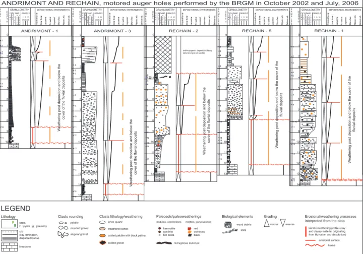
C L A Y S I L T GRANULOMETRY
ANDRIMONT AND RECHAIN, motored auger holes performed by the BRGM in October 2002 and July, 2006
F I N E M E D I U M C O A R S E GRAVELS 1 cmcm5 SAND 10 cm DEPOSITIONNAL ENVIRONMENTS Proximal fl uv ial Distal fluvia l Pa lu st ra l La goonal Shore fac e Above s.w.b. Below s.w.b. Lacustrin e LEGEND sand, P : pyrite ; g : glaucony silt clay lamination, dispersed/dense rounded gravel pebble angular gravel hiatus reverse normal
Clasts rounding Grading
erosional surface
g P
oxided pebble with black patina oxided gravel nodules, concretions haematite goethite Mn oxide mottles, punctuations red ochreous black Biological elements wood debris stick ferruginous duricrust Paleosols/paleoweatherings limestone 1 3 4 6 7 8 9 10 5 2 0 1 9 11 2 3 4 5 6 7 8 10 Clasts lithology/weathering weathered schist white quartz S A M P L E S D E P T H ANDRIMONT - 1 13 10 15 12 1 2 3 4 5 6 7 8 9 10 11 12 13 14 15 16 1 3 4 6 7 8 9 11 5 2 0 14 DEPOSITIONNAL ENVIRONMENTS Proximal fl uv ial Distal fluvia l Pa lu st ra l La goonal Shore fac e Above s.w.b. Below s.w.b. Lacustrin e S A M P L E S D E P T H ANDRIMONT - 3 6 7 8 9 10 9 11 12 13 14 15 16 17 11 12 13 1 3 4 5 2 0 1 2 3 4 5 6 7 8 2 bis 2 ter 10 W
eathering post deposition and below the
cover of the fluvial deposit
s DEPOSITIONNAL ENVIRONMENTS Proximal fl uv ial Distal fluvia l Pa lu st ra l La goonal Shore fac e Above s.w.b. Below s.w.b. Lacustrin e S A M PL E S D E P T H RECHAIN - 2
anthropogenic deposits (clayey sand and gravel waste)
10 12 1 2 3 4 5 6 7 8 9 10 11 12 13 14 15 16 1 3 4 5 2 0 6 7 8 9 11 13 W
eathering post deposition and below the cover of the
fluvial deposit s DEPOSITIONNAL ENVIRONMENTS Proximal fl uv ial Distal fluvia l Pa lu st ra l La goonal Shore fac e Above s.w.b. Below s.w.b. Lacustrin e S A M P L E S D E P T H RECHAIN - 5
karstic weathering profile (clay and clayey material originating from illuviation and dissolution)
C L A Y S I L T GRANULOMETRY F I N E M E D I U M C O A R S E GRAVELS 1 cmcm5 SAND 10 cm C L A Y S I L T GRANULOMETRY F I N E M E D I U M C O A R S E GRAVELS 1 cmcm5 SAND 10 cm 1 3 4 6 7 8 9 10 5 2 0 1 9; 10 11 W
eathering post deposition and below the cover of the
fluvial deposit s 2 3 4 5 6 7 8 12 13 14 15 16 17 11 12 13 14 DEPOSITIONNAL ENVIRONMENTS Proximal fl uv ial Distal fluvia l Pa lu st ra l La goonal Shore fac e Above s.w.b. Below s.w.b. Lacustrin e S A M P L E S D E P T H RECHAIN - 1 C L A Y S I L T GRANULOMETRY F I N E M E D I U M C O A R S E GRAVELS 1 cmcm5 SAND 10 cm C L A Y S I L T GRANULOMETRY F I N E M E D I U M C O A R S E GRAVELS 1 cmcm5 SAND 10 cm
Lithology Erosional/weathering processes
interpreted from the data
W
eathering post deposition and below the
cover of the fluvial deposit
s
W
eathering post deposition and below the
cover of the fluvial deposit
s
s1, from top to bottom (Fig. 2): •
0-0.25 m: agricultural soil o
0.25-0.75 m: slightly silty beige clay o
0.75-1.25 m: brown clay with numerous angular o
quartz and rock gravels
1.25-1.9 m: ochreous to red-brown clayey coarse o
quartz sand; the grains, including some small gravels, are angular 1.9-1.95 m: reddish brown clayey medium sand o
1.95-2.3 m: pale red-brown plastic clay with cm- o
sized pieces of Fe-Mn sandstone 2.3-9.5 m: brown clay with rare oxidized rock o
debris ; from 6.5 m downwards, HCl-reactive
9.5-10.5m: transition toward the dolostone o
bedrock.
s2: 4.5 m diversely coloured (dark ochreous to beige) •
plastic clay with ferruginous concretions, resting on the dolostone bedrock.
s3, from top to bottom (Fig. 2): •
0-1 m: ochreous plastic clay (1) with rare o
gravels and ferruginous concretions 1-2.5 m: clayey coarse sand (2, 3); angular o
grains + some small white quartz pebbles
2.5-3.4 m: variegated ochreous plastic clay o
(4) with rare small quartz pebbles and sandstone debris
3.4-5.2 m: slightly sandy, ochreous and light o
grey clay (6)
5.2-7.5 m: medium to coarse sand (8, 10), o
ochreous then light beige ; angular grains + numerous small quartz pebbles
7.5-13.5 m: slightly clayey ochreous sand (11, o
13, 14) with alluvial gravels (shale, sandstone, quartzite, fibrous quartz) ; the sand grains are angular to subrounded
13.5-15 m: brown clay going rapidly into o
fresh dolostone.
Rechain (Geodoc 135E1096 to 1099 and 1171)
Five motored auger holes have been carried out on a levelled topography cutting the limestones of the Dinantian Bay Bonnet and Juslenville groups at 268-275 m altitude.
s1, from top to bottom (Fig. 2): •
0-0.3 m: ochreous silt o
0.3-3.7 m: light grey fine sand (1, 3) with thin o
intercalations of ochreous clayey sand
3.7-4.5 m: light grey medium sand (4) with o
dark ochreous clayey layers (4b) at the base
4.5-5 m: light grey fine sand with thin o
intercalations of ochreous clayey sand
5-6.2 m: light ochreous clayey fine sand (7) o
with numerous rounded milky quartz pebbles (0.5-5 cm) and rare angular black chert pieces
6.2-7.5 m: very coarse sand (8) to sandy gravel ; o
the sand grains are angular but the larger quartz gravels (2-5 mm) are fairly rounded
7.5-10 m: chocolate brown clayey and gravelly o
sand (11, 13) with rounded white quartz pebbles (up to 5 cm in size) ; some thin layers of pink clay (12); at 9.5-9.7 m, well-sorted ochreous coarse sand (14) with rare quartz pebbles
10-13.4 m: clayey fine sand (15, 16) with quartz o
pebbles and one 12-cm-long rounded Ardennian quartzite ; Fe-Mn oxides 13.4-13.5 m: brown clay going into the fresh o
limestone. s2, from top to bottom (Fig. 2): •
0-3.5 m: clayey sand and gravel waste o
3.5-4 m: blue-grey to dark blue plastic clay o
4-4.5 m: grey-brown plastic clay with o
weathered quartz gravels and black sandy layers rich in wood debris 4.5-9.1 m: whitish to reddish-brown sand with o
reverse grading : very coarse at the top (D50 ~0.7-0.8 mm) and fining downwards (D50 ~0.1-0.2 mm at the base) ; the sand grains and small quartz gravels are angular
9.1-10.3 m: transition from a brown clayey sand o
to a brown clay with ferruginous granules and small quartz gravels 10.3-12.7 m: brown plastic clay going into the o
fresh limestone. s3, from top to bottom:
•
0-0.5 m: agricultural soil o
0.5-2.5 m: grey and salmon pink gravelly sand o
with thin clay layers; the sand grains are angular
2.5-10 m: variegated clayey and gravelly sand; o
the number and size of the gravels increase downwards, with white quartz and sandstone pebbles up to 5 cm long at the base
10-11.7 m: dark brown to black manganiferous o
clay. The borehole had to be stopped before reaching the bedrock. s4, southwestern limit of the deposit, from top to •
bottom:
0-0.5 m: beige silt o
0.5-1.4 m: ochreous sand with thin layers of o
angular quartz gravels (< 3 mm) 1.4-2.4 m: light yellow medium sand o
2.4-3.5 m: dark brown silty clay o
3.5-4.5 m: coarse to medium ochreous sand o
with rare quartz gravels. The borehole had to be stopped before reaching the bedrock.
s5, from top to bottom (Fig. 2): •
0-0.4 m: silt o
0.4-2.7 m: silty clay (2) rapidly going into a o
yellow to brown clayey silt with rare Fe-Mn nodules
2.7-6.2 m: light yellow medium sand with o
white quartz pebbles (up to 4 cm in size); some thin intercalations of brown clayey sand
at 6.2 m: 2 to 5-cm-thick layer of pink clay o
6.2-6.7 m: yellowish white gravelly sand with o
rounded quartz elements > 0.5 cm 6.7-7.3 m: white medium sand fining o
downwards and becoming ferruginized
7.3-7.5 m: very compact white-beige clay (11) o
with rounded, mostly deeply weathered quartz gravels
7.5-8 m: very clayey, gravelly ochreous sand o
8-12.5 m: dark purple to black clay (14, 15, o
16) pigmented by Mn-Fe oxides, with Mn-oxide concretions (up to 3 cm in size) and a few small quartz pebbles. At the bottom, manganese- iron ore pieces 5-10 cm in size and limestone blocks coloured by the Mn-oxides in contact with the limestone bedrock.
Magnée (Geodoc 135W1000 and 1344)
Two motored augerholes have explored a SBL deposit overlying the limestones of the Dinantian Bay Bonnet and Juslenville groups on a topographic bench at 230 m altitude.
s1, from top to bottom: •
0-0.2 m: agricultural soil o
0.2-1.5 m: ochreous-brown plastic clay o
1.5-3.2 m: ochreous-brown plastic clay (more o
sandy between 2 and 2.2 m) with flints (up to 5 cm in size), resting on the fresh limestone. Some flints are deeply weathered, and they become smaller and scarcer downwards.
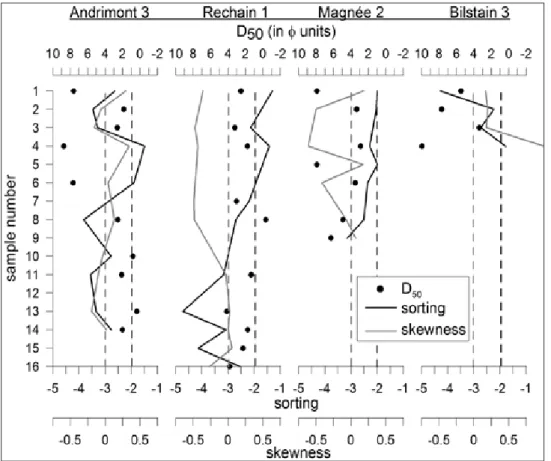
1 10 100 1000 10000 100000 grain size (m) 0 20 40 60 80 100 1 2 4 6 8 5 9 % Magnée - s2 1 10 100 1000 10000 100000 grain size (m) 0 20 40 60 80 100 1 2 4 3 % Bilstain - s3 1 10 100 1000 10000 100000 grain size (m) 0 20 40 60 80 100 11 1 3 4 7 8 13 14 15 16 % Rechain - s1 1 10 100 1000 10000 100000 grain size (m) 0 20 40 60 80 100 1 2 3 4 6 8 10 11 13 14 % Andrimont - s3 figure 3. Cumulative granulometric curves in four boreholes representative of the four sites. The numbers refer to the sample numbering provided between paren-theses in the text description of the boreholes.
s2, from top to bottom: •
0-0.4 m: silt with flints o
0.4-1 m: slightly sandy clay with flints o
1-1.5 m: ochreous and light grey plastic clay o
(1), without flint
1.5-3.4 m: brown sandy clay (2, 3) grading o
downwards into a light yellow, slightly clayey medium sand (4) with angular grains
3.4-5.8 m: ochreous clay (5) with Fe(-Mn) o
concretions, again going progressively downwards into a yellow clayey sand (6) with rare flint splinters between 4.3 and 5.5 m 5.8-6.8 m: light ochreous clay; around 6 m, o
numerous large, rather fresh flints (up to 15 cm in size)
6.8-7.2 m: alternating ochreous sandy clay and o
clayey sand (8) layers 7.2-7.5 m: light ochreous clay (9, 15) o
7.5-9.8 m: alternating ochreous sandy clay o
(predominating) and clayey sand layers, resting on the limestone bedrock.
analytical results
Grain size and shape
We briefly present here the results of grain size analyses carried out on samples of the most representative augerhole
in each site investigated. The analyses were performed by laser diffractometry, using a Malvern grain size analyser for the fraction < 595 mm, and by sieving for the coarser fraction. The cumulative granulometric curves of Fig. 3 are expressed in weight percents. For the sample characterization, we will use the median (D50), and the sorting and skewness coefficients defined by Folk and Ward (1957) (Fig. 4). The sorting coefficient is defined as:
So = (f84 – f16)/4 + (f95 – f5)/6.6 and the skewness coefficient as:
Sk = (f84 + f16 – 2f50)/2(f84 – f16) + (f95 + f5 – 2f50) /2(f95 – f5)
The Andrimont 3 samples display a clear-cut separation between almost pure clays (D50 within the range 2-5 mm), located in the upper half of the profile, and medium to coarse sands (mostly 250 mm < D50 < 750 mm) rather poorly sorted. Whereas the sand layers show a fairly symmetric grain size distribution, the clays have positive Sk values betraying a tail towards the coarser part of the distribution curve.
The Rechain 1 samples are exclusively sandy. There are however rapid lateral facies variations as the borehole of Rechain 5, which is only ~100 m apart from Rechain 1, revealed more than 4 m clays at the base. The main characteristic of the profile at Rechain 1 is the contrasted sorting between the bottom part, with badly sorted silty fine to medium sands, and the top part displaying sands of similar D50 but much better sorted. However, the latter
figure 4. Granulometric D50, sorting and skewness profiles of boreholes representative of the four sites. The dashed light grey and black lines respectively represent 0 skewness (symmetrical grain distribution) and an empirical limit for good sorting (So > -2).
also show strong negative Sk values signalling a non negligible part (~10%) of silt and clay.
The sediment sequences in these two sites are suggestive of a terrestrial environment: while the basal clay layers generally represent in situ weathering residues of the limestone bedrock, the overlying interlayered sands and clays indicate local river transport and lacustrine/ palustrine conditions.
The Magnée 2 profile exhibits an alternation of clays and fine sands, fairly sorted except at the base of the deposit. The negative skewness of the sands shows that they nevertheless remain rich in silt and clay (with even a bimodal distribution for the sample 4 – Fig. 3).
Finally, overlying a very pure residual clay (D50 < 1 mm) derived from the solution of the bedrock carbonates, the sediments in Bilstain 3 are poorly sorted silts to fine sands with a variable fraction of coarser elements. The D50 around 30 mm and the bimodal grain size distribution of the top silt might betray a mixing of loess with local material.
The shape of the sand and gravel grains observed under a binocular lens confirms the above conclusion that the sand layers at Andrimont and Rechain show no trace of a marine origin. All quartz sand grains (up to 2 mm in size) are angular to subangular. In the sands of Andrimont 3 and Rechain 1, 3 and 5, the weak rounding of the coarser grains (> 3-4 mm) becomes typically better with increasing diameter of the elements, to reach roundness values characteristic of river transport for small, centimetre-sized quartz pebbles. This again seems to indicate a transport over limited distances. By contrast, although very rare within the bulk of angular grains, some shining, perfectly rounded quartz sand grains may be observed in the samples of the lower half of the Magnée deposit (6, 8, 9), bearing witness to the shade of a component of marine origin in the sands.
Clay mineralogy (XRD)
The clay fraction (< 2µm) of samples representative of the clay and silt layers was analysed by X-ray diffractometry (Siemens Cristalloflex 4). The semi-quantification of the results, presented in Table 1, was achieved using a procedure derived from that of Holtzappfel (Holtzappfel, 1985). Illite-mica, kaolinite, and four smectitic mixed-layers (illite-smectite IS-R0 and IS-R1 (Pletsch, 1997), chlorite-smectite CS, vermiculite-smectite VS) are the main components, while chlorite is systematically present in minor quantities. Two parameters measured on the XR-diagrams were also calculated in order to support the interpretation, namely the K/K+2C ratio directly deduced from the intensities of the peaks 004 (chlorite) and 002 (kaolinite), and the saddle/I001 ratio (Inoué & Utada, 1983). K/K+2C reflects the relative proportion of chlorite and kaolinite. The value of the saddle/I001 ratio depends on the percentage of smectite layers in the mixed layer R0. In addition, lepidocrocite was identified in the clay fraction of the Andrimont samples.
Table 1 shows the very heterogeneous distribution of the clay minerals and intergrades among the samples. With the exception of augerhole s5 at Rechain, where it amounts to ~5%, chlorite is present only as traces. The illite-mica component is particularly well represented in the samples of Andrimont (> 60%), whereas low percentages (< 10%) are characteristic of the Magnée site. In Rechain and Bilstain, the illite-mica percentages are in the 20-35% range. Beside low amounts of illite-mica, the high contents (35-90%) in the IS-R0 smectitic mixed layer are a main feature of the Magnée samples. Moreover, the increasing proportion of smectite layers in the mixed layers, evidenced by the saddle index evolution from top to bottom in the Magnée s2 borehole, remarkably parallels the downward increase in IS-R0. While the latter is also well represented in the Rechain site, especially in table 1. X-ray diffraction analysis of clay layers in boreholes representative of the four sites.
Chlorite
Illite-mica IS R0 IS R1 14-14 Kaolinite K/K+2C Saddle/ I001 % Smect. in IS R0 various
BILS3-2 1 34 14 - 21 CS 30 96.4 - -BILS3-5 1 26 21 - 21 CS 31 94.9 - -ANDR3-1 1 89 - - - 10 94.9 - - Lépidoc. ANDR3-4 2 59 9 15 - 15 83.3 - - Lépidoc. RECH1-4b 1 28 10 9 10 VS 42 96.2 - -RECH1-12 1 23 22 4 10 VS 40 97.8 - -RECH5-2 6 37 18 14 15 VS 10 50 - -RECH5-11 5 21 29 4 13 VS 28 78.1 - -RECH5-14 3 19 23 6 24 VS 25 86.2 - -RECH5-16 4 29 30 4 13 VS 20 79.9 - -MAGN2-1 1 8 67 - - 24 81 0.70 ~55 MAGN2-3 3 7 35 - - 55 93.7 0.87 ~50 MAGN2-5 1 9 89 - - 1 48.2 0.37 ~70 MAGN2-15 1 9 89 - - 1 38.4 0.33 ~75
augerhole s5, IS-R1 and V-S are more typical of the two Rechain boreholes.
In summary, each site has its specific clay composition. At Bilstain, the presence of C-S mixed layers associated with relatively high percentages of kaolinite and I-S R0 mixed layers consistently suggests a weathered but probably immature chlorite-bearing source. Andrimont is characterized by a high illite-mica content pointing to a probable detrital origin of the fine fraction, possibly derived from the reworking of weathered mature rocks like, e.g., Lower Paleozoic shales (Dupuis, 1992; Yans, 2003). As for Rechain, the two augerholes we examined are very similar in characteristics, namely displaying a complex assemblage of mixed layers, with especially V-S and IS-R1, a relatively high content of kaolinite and a moderate representation of illite-mica that all together refer again to weathering, perhaps slightly more pronounced in augerhole s1 (with very high K/K+2C values). By contrast, Magnée is marked by a very low illite-mica content, the highest percentages of IS-R0, and an opposed variation, from top to bottom, between increasing IS-R0 (+ increasing smectite content within the IS-R0) and decreasing kaolinite contents. These features might be indicative of either a profile developed within an
in situ sequence or the reworking of a regional profile
reversely recorded in the pocket sediments. Mineralogically, the clay assemblage at Magnée reminds of that of the so-called ‘smectite de Herve’ (Vaals Formation), containing chlorite (25%), illite (10-75%), smectite (or IS R0, 20-85%) and kaolinite (15%) (after Thorez & Monjoie, 1973), but it is also quite similar to the clay assemblage encountered in the Aachen Formation (Spagna et al., 2004).
Transparent heavy minerals
Although in principle more appropriate for provenance studies than stratigraphical purposes, the transparent heavy mineral association of the sands has been examined with the aim of detecting the presence of minerals typical for the post-Eocene sediments of the Anglo-Belgian basin and its southern margin, and in particular the Early Oligocene marine sands of the study area. These minerals pertain to the parametamorphic mineral assemblage, with kyanite, andalusite and staurolite being most frequent (e.g., Demoulin, 1987b). In the marine Oligocene sands of eastern Belgium, they generally appear as well rounded grains 150-750 mm in size.
However, the Bilstain samples only revealed minute grains mainly of zircon, with subordinate quantities of tourmaline and rutile.
In Rechain and Andrimont, all sands show a similar assemblage, again exclusively made of zircon, tourmaline and rutile. The approximate percentages are >50% zircon, ~30% tourmaline and ~10% rutile, except in sample 4 of Rechain 1 where the tourmaline predominates. Surprisingly, all samples are characterized by a mixing of angular heavy mineral grains with many grains (for up to 30-50% of the total in some samples) displaying an almost perfect roundness indicative of their marine origin. These rounded grains are inherited, but certainly not from the Oligocene sand cover, as the absence of parametamorphic grains definitively precludes it.
In contrary to Rechain and Andrimont, the Magnée sands contain not only zircon, tourmaline and rutile, but also small quantities (totalizing 2-10%) of kyanite and staurolite. However, all grains are angular or subangular.
Despite the HCl-HNO3 treatment applied to the samples to clear the Fe-oxide coating off the grains, there remained a large number of opaque heavy minerals in all samples of Rechain, Andrimont and Magnée. Their look under the binocular lens suggests that their often rounded shape would respond to a concretionary process rather than transport over long distances.
Mn oxide dating
As the Mn oxides present in the basal clay of Rechain 5 seem to have resulted from neoformation by chemical weathering, they offer an opportunity to date the weathering process and thus to provide some support to the discussion of the age of the deposit. Indeed, during the last decade, K-Ar dating (and 40Ar/39Ar laser probe step-heating analyses) of minerals of the hollandite group has been widely used to constrain the chronology of weathering phases all around the world: in Australia (e.g., Dammer et al., 1999), Europe (e.g., Hautmann and Lippolt, 2000), Asia (e.g., Li et al., 2007), America (e.g., Spier et al., 2006), Western Africa (Beauvais et al., 2008) and Northern Africa (Decrée et al., in press). This method yields reliable ages because hollandite-group minerals are supergene, contain potassium and keep the radiogenic argon gas in the tunnel-structure of the cristal (Vasconcelos, 1999).
K-Ar dating of two Mn-nodules (samples RECH-A3 and RECH-A4) from 8-12.5 m depth in the Rechain s5 borehole has been performed at the University of Strasbourg. Millimetre-sized nodule fragments were handpicked from crushed rocks under a binocular microscope. XRD analyses showed that the minerals are from the hollandite group, with Fe-Mn substitutions. About 0.2 g of material was used for each K analysis, and 0.02 g for each Ar analysis. K-Ar determinations were table 2. K-Ar data of the Mn-nodules from the Rechain s5 borehole.
Samples K2O (%) Ar (%) 40Ar (10-6 cm3/g) Age (Ma±2σ)
RECH5-15/1 3.26 67.00 10.87 94.8 ± 4.0
obtained using a method first established by Bonhomme et al. (1975). In order to remove the atmospheric Ar adsorbed onto the particles during sample handling, preparation and size fractionation, the samples were heated at 80°C under vacuum prior to Ar extraction. The K was measured by flame spectrophotometry with an internal accuracy better than 1.5%. The analytical precision was periodically controlled by measuring the international glauconite standard GL-O, which averaged (24.74 ± 0.06)*10-6 cm3/g (2σ) of radiogenic 40Ar in the STP system for 3 independent measurements during the course of the study, and the atmospheric 40Ar/36Ar ratio which averaged 291.8 ± 5.5 (2σ) for 6 independent determinations. The recommended value for the standard is (24.85 ± 0.24)*10-6 cm3/g of radiogenic 40Ar, and that for the atmospheric 40Ar/36Ar ratio is 295.5. As the control data were internally consistent with very limited scatter and as they were close to the theoretical values, no correction was applied to the raw isotopic determinations.
Based on the decay constants given by Steiger & Jäger (1977), our K-Ar data provide fairly accurate and consistent ages between 88.4 ± 3.8 and 94.8 ± 4.0 Ma, thus placing the formation of the dated Mn oxides between the Cenomanian and the Santonian (early Late Cretaceous) (Gradstein et al., 2004) (Table 2).
Plant macrorests
While the sediments were totally devoid of pollen, abundant millimetric to centimetric organic fragments have been collected from a clay layer in the upper half of the augerhole s2 at Rechain. They are badly preserved and consist of charcoalified and/or coalified plant tissue specimens. All are brittle and bright black in colour (Fig. 5A). They were not evaluated from a petrologic point of view, but they presumably are either semifusinite from the inertinite group macerals (representing fossil charcoal; Scott, 2002) or vitrinite (derived from coalified woody tissue; Hatcher & Clifford, 1997). Their bad preservation
probably indicates high charcoalification and/or coalification levels. Such preservational states are usually interpreted as resulting from wildfires before burial (Scott, 2002) and/or diagenetic processes. Most of the specimens are structureless (Fig. 5B). No specimens representing secondary xylem (wood) of gymnosperms or angiosperms were observed. Rare samples show some cellular preservation. The cells illustrated in figures 5C and D are tracheids with annular to scalariform pitting. This type of cell ornamentation is suggestive of the primary xylem tracheids of monilophytes (ferns sensu lato). As a whole, the collected specimens from the Rechain s2 borehole are not well enough preserved to infer any precise environmental conditions.
discussion
Although they are all categorized as SBL on the new geological maps, the investigated deposits are definitely of various origins. We will thus discuss separately the deposits of Bilstain, the Rechain-Andrimont pair, and Magnée.
Bilstain
All characteristics of the Bilstain deposits point to a local origin as a more or less in situ weathering product of the underlying bedrock. Not only goes the predominantly clayey material gradually downwards into the fresh bedrock, but the petrographic, mineralogical and granulometric nature of the sediment leaves no doubt about it. Its variable thickness, generally between 3 and 5 m, reflects the topography of the bottom of the solution pocket in the dolostones. The age indications are very few: we only know that there is no mixing with sediments from the Late Cretaceous or Early Oligocene covers of the area (absence of flints, fluvial or marine sands, specific heavy minerals) and that the deposit rests on a levelled surface at ~275-285 m altitude, vertically very close to the exhumed pre-Cretaceous surface. Therefore, it could
figure 5. a. Gross view of one coalified and/or charcoalified plant tissue specimen (PTR-C-1, scale bar: 0.5 mm). B. Bright structureless area from specimen PTR-C-1. Scale bar: 100 µm. C-d. Tracheids with annular to scalariform pitting from specimen PTR-C-1. Scale bar: 100 µm.
result from either the chemical weathering associated with the erosion surface that was forming during the Early and early Late Cretaceous, or renewed weathering when the surface was exhumed from its Cretaceous and Oligocene covers and regraded, probably in the course of the Miocene. Owing to the complete absence of trace of Cretaceous sediments, and also by analogy with what we observe elsewhere (see below), we would privilege a Cretaceous age. Note also that, beside the dolomitic nature of the bedrock inducing the presence of chlorite-smectite, the slight contamination by Quaternary loess suggested by the grain size analysis might also account for the clay mineralogy of the Bilstain deposit, featuring equal amounts of illite and kaolinite.
In the unpublished archives of the Geological Survey of Belgium at Brussels, Gulinck reported in 1952 that he performed a number of shallow boreholes in the same area northeast of Bilstain. He made field observations similar to ours and proposed the same interpretation of the deposit as a local weathering product, partly reworked in places.
Rechain and Andrimont
The Rechain and Andrimont sediments are the most representative of SBL deposits commonly attributed to an Early Oligocene sand cover in eastern Belgium (all Eocene and Paleocene deposits of central Belgium wedge out eastwards and are totally eroded in SE Limburg, so that their presence farther SE is rather unlikely). These 4 km apart deposits share a number of features that make them probably belong to the same stratigraphic unit. Indeed, both of them are trapped into dissolution pockets of the Dinantian limestones and dolostones, with an irregular bottom locally reaching a depth of 15 m. They exhibit rapid vertical and lateral facies variations, alternating river sands and lacustrine clays above a basal unit of weathering clay. The variety of grain size distributions is not fundamentally different in the two sites, some layers of river sand being however particularly well sorted in Rechain. Both sequences are totally devoid of Cretaceous flints and contain no trace of Early Oligocene marine sands (no parametamorphic minerals, no marine rounding of the quartz sand grains). As for the rather distinct clay composition of the two sites, it might simply reflect the diverse nature and weathering state of the nearby sediment sources.
Obviously, the Rechain deposit provides highly useful material for the age determination. The pervasive pigmentation by Mn oxides of the clay layer containing the Mn nodules at the base of the Rechain s5 augerhole, the similar pigmentation of the top of the bedrock, and the absence of rounding of the nodules, all strongly support in
situ neoformation of the Mn oxides. As evidenced by the
black oxide coating of illuviated sand grains, this oxidizing episode occurred most likely after deposition of the overlying sands and clays. Therefore, the early Late Cretaceous age of the Mn oxides constrains the time of
deposition, which should be somewhat older. The limited information provided by the plant remains found in the same site does not contradict the age assigned to the deposit.
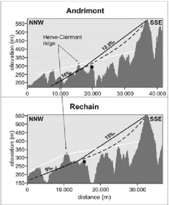
Moreover, the Andrimont and Rechain deposits are located at an elevation very close beneath the exhumed pre-Cretaceous surface, not far from the place where it emerges from below the remaining Cretaceous cover (Fig. 6), and it is actually surprising that their Cretaceous age was not recognized earlier. Indeed, the sediments are remarkably similar to those of the Middle Santonian Hergenrath and Aachen members of the Aachen Formation in the type area southwest of Aachen: “alternation of light
to dark grey, sandy and silty clays with silty and clayey, light grey fine to coarse-grained sands, with subordinate fine-grained gravel, silts ... Locally with large quantities of wood debris” (Hergenrath Member); “well-sorted, yellow-white … fine sands, locally with irregular gravelly sandstone beds” (Aachen Member) (Robaszynski et al.,
2001). Laloux et al. (2000) also mentioned blue-grey to black silty clays, silts, and clayey sands with numerous plant debris, as well as centimetre-size white quartz pebbles in the Hergenrath deposits of the northeast Pays de Herve. Likewise, Laloux et al. (1996b) described fine sands with plant debris and manganese concretions, and
figure 6. NNW-SSE topographic profiles showing the location of the Andrimont and Rechain SBL deposits (black dots) very close (~20 m) below the trace of the pre-Cretaceous erosion surface (solid black line: linear interpolation of the surface trace, dashed line: surface trace including the presence of a slight flexure towards the Hautes Fagnes ridge). In white, the trace of the pre-Oligocene surface passes much higher (70-130 m) above the SBL deposits.
dark purple clays in the same Member close to Battice. It is also worth noting that the gravelly sands with rounded quartz pebbles of Rechain and Andrimont closely resemble the quartz gravels of the Mospert Member (Renier, 1925; Herbst, 1969), a southeast equivalent of the Hergenrath Member.
The location of the Andrimont and Rechain deposits makes them the westernmost extended remains of the Hergenrath Member, just outside the area where even the thicker Aachen Formation tapers and disappears. However, in the unpublished archives of the Geological Survey of Belgium, Dusar reported in 2005 that an excavation dug at 190 m altitude between Tignée and Barchon exposed, below flint-bearing loam, a 1.5-m-thick layer of grey-brown clay overlying 1 m of coarse to gravelly sands with lignite lenses. He explicitly interpreted these sediments located ~10 km to the NW of Rechain as pertaining to the superposed Mospert and Hergenrath Members. Like the Mospert gravels, the Rechain, Andrimont and Tignée deposits might thus represent the last witnesses, best preserved within dissolution pockets, of a formerly more extended mixed cover of fluvial sands and (reworked) deep weathering products at the northern rim of the Ardennes during the early Late Cretaceous, very similar in that to the Wealden facies of the Hainaut Group in western Belgium and northern France (Quinif et al., 2006). Though difficult to date, these dissolution pockets probably developed concomitantly to the sedimentation since, unlike Magnée, the Rechain and Andrimont deposits display no trace at all of later marine Cretaceous sediments. Not so surprisingly, the Mn oxide dating at Rechain extends also the age of the continental deposits of the Hergenrath Member from the Santonian (Batten et al., 1988) possibly back to the Late Cenomanian, making the east-west correspondence still more striking, (namely with the Saint-Pierre Formation of the Mons basin; Yans et al., 2007). Moreover, there is a spatial continuum between these deposits, generally of moderate thickness and later mostly swept away by the Cretaceous sea transgression around the Ardennes, namely through the extensive remains of the kaolinic weathering mantle still veiling the old erosion surfaces inside the massif and also recently dated - at least for the upper part of the profiles - from the Early to early Late Cretaceous (Yans, 2003; Yans & Dupuis, 2005; Quesnel et al, 2006; Thiry et al., 2006). Magnée
The geomorphological position of the Magnée deposit is somewhat different from that of Andrimont and Rechain. At 225-230 m altitude, it is located hardly 300 m apart from a southern extension of the Cretaceous continuous cover of the Pays de Herve, whose base is mapped there at 245 m altitude. The solution pocket in which it is preserved thus holes a topographic bench developed ~20 m below the pre-Cretaceous erosion surface. However, it is difficult to determine whether the bench was an original part of this surface locally subdued on the limestone bedrock or was carved in later (Neogene) times. Moreover, a younger
bench might either have truncated a pre-existing filled solution hollow, or have induced the creation of a new dissolution hole with younger filling.
The sediments obviously display a component of weathering residue of the Cretaceous chalks, appearing as the brown to ochreous clayey levels, with or without flints, while the clay content of some layers (table 1) also strongly reminds of the Herve smectites of the Vaals Formation. The provenance of the generally fine quartz sand fraction of the deposit, mixed or interlayered with the clay, is more problematic. Indeed, the local Vaals deposits are predominantly silty to clayey. The very rare round sand grains in some layers and the few kyanite and staurolite grains show that the Oligocene marine sands hardly participated in the deposit at Magnée. Therefore, the sand layers can most likely be attributed to the Aachen Formation. However, the Oligocene sand grains present in the lower half of the deposit demonstrate that the latter cannot be interpreted as an in situ weathering product of the Cretaceous cover but is rather made of reworked material. This is further suggested by the general difficulty to trace back the original Cretaceous stratigraphy at Magnée and by the particular observation that flints mixed in a single level reveal biostratigraphical ages, based on silicified foraminifera, ranging from Late Campanian to Early Maastrichtian. It seems thus that here, the development and filling of the dissolution pocket was posterior to the Cretaceous and consequently occurred after the topographic bench had been created, i.e. probably in the late Neogene, in a time when most of the Oligocene sands had already been removed.
Conclusion
This study has illustrated how, although put together in the single SBL category of the new geological map of Belgium, the SBL deposits scattered along the southern margin of the Pays de Herve may have had different particular histories. Based on field observation and various analyses of the drilled sediments, we have shown that Bilstain represents local weathering products. By contrast, although still recently ascribed to the Oligocene, Rechain and Andrimont are early Late Cretaceous alluvial and lacustrine deposits preserved in dissolution pockets just below the pre-Cretaceous erosion surface close to the southern border of the contiguous Cretaceous cover of the Pays de Herve. They belong to the basal member of the Aachen Formation, from which they constitute a southwest outpost, in an area where this member had never been described before. As far as we know, the Mn oxide dating in Rechain provides the first firm indication of the age of the Hergenrath Member and puts its lower limit significantly back in time, giving it an age of ~90-95 Ma (Late Cenomanian to Turonian). This was a time when the Cenomanian transgression had already started in the southern North Sea basin, with green sands deposition along the southern margin of the Münster basin (Vejbaek et al., 2009) but, due to the presence of the inverted RVG, the Campine basin and eastern Belgium were still emerged
lowlands where wealden-type sedimentation should have prevailed. This age assignment also perfectly fits the geomorphological dating of the surface bearing the deposits. Finally, the Magnée sediments are more difficult to decipher, but it seems that they comprise mainly reworked weathering products of the Cretaceous cover, possibly accumulated during a later geomorphic stage, when a Late Neogene topography developed at the expense of the exhumed pre-Cretaceous erosion surface.
acknowledgments
We gratefully thank the landowners MM. Bauduin, Delbussaye, Archambault, Lambert, and Juprelle, who kindly authorized us to sink the augerholes in their ground. We acknowledge the field assistance of Mathieu Schuster and the BRGM drilling team (Daniel Dupuy, Jean-François Lozac’h and Gilbert Guizouarn). The analytical help from N. Clauer (University of Strasbourg) was greatly appreciated. Chantal Bourdillon (ERADATA) provided the biostratigraphical information on the Magnée flints. This paper is a contribution to the research program and projects of the BRGM: ‘Programme de la Carte Géologique de la France’, ‘Géodynamique des enveloppes externes’, et ‘Géologie de la Surface’. We are also indebted to the two reviewers, M. Dusar and R. Simon-Coinçon, for their constructive and helpful comments, which significantly improved the quality and broadened the scope of this paper.
references
ALBERS H. & FELDER W., 1979. Litho-, biostratigraphie und Palökologie der Oberkreide und des Alttertiärs (Präobersanton-Dan/Paläozän) von Aachen – Südlimburg (Niederlande, Deutschland, Belgien). In Wiedmann J. (ed), Aspekte der Kreide Europas. International Union of Geological Sciences Series A 6: 47-84.
BATTEN D., DUPAGNE-KIEVITS J. & LISTER J., 1988. Palynology of the upper Cretaceous Aachen Formation of northeast Belgium. In Streel M. & Bless M. (eds), The chalk district of the Euregio Meuse-Rhine: 95-103.
BEAUVAIS A., RUFFET G., HéNOCQUE O. & COLIN F., 2008. Chemical and physical erosion rhythms of the West African Cenozoic morphogenesis: The 39Ar-40Ar dating of supergene K-Mn oxides. Journal of Geophysical
Research, 113, F04007, doi:10.1029/2008JF000996.
BLESS M. & FELDER P., 1989. Note on the Late Cretaceous of Hockai (Hautes Fagnes, NE Belgium).
Annales de la Société Géologique de Belgique, 112:
47-56.
BONHOMME M.G., THUIzAT R., PINAULT Y., CLAUER N., WENDLING A. & WINKLER R., 1975. Méthode de datation Potassium-Argon. Appareillage et techniques. Note technique, Institut Géologique de Strasbourg.
BOURGUIGNON P., 1954. Les sables des Hautes Fagnes.
Annales de la Société Géologique de Belgique, 77:
B201-241.
DAMMER D., MCDOUGALL I. & CHIVAS A.R., 1999. Timing of weathering-induced alteration of manganese deposits in Western Australia: evidence from K-Ar and 39Ar-40Ar dating, Economic Geolology, 94: 87-108. DECRéE S., RUFFET G., DE PUTTER T., BAELE J-M., RECOURT P., JAMOUSSI F. & YANS J. 2009. Mn oxides as efficient traps for metal pollutants in a polyphase low-temperature Pliocene environment: a case study in the Tamra iron mine, Nefza mining district, Tunisia.
Journal of African Earth Sciences, doi: 10.1016/j.
jafrearsci.2009.08.005.
DEMOULIN A., 1987a. The distribution of Cretaceous deposits on the Hautes Fagnes plateau (Belgium).
Geologie en Mijnbouw, 66: 147-150.
DEMOULIN A., 1987b. Les sables oligocènes du plateau des Hautes Fagnes: une synthèse. Bulletin de la Société
belge de Géologie, 96: 81-90.
DEMOULIN A., 1995. Les surfaces d’érosion méso-cénozoïques en Ardenne-Eifel. Bulletin de la Société
Géologique de France, 166: 573-585.
DEMOULIN A., 2006. La néotectonique de l’Ardenne-Eifel et des régions avoisinantes. Mémoires de l’Académie
Royale de Belgique, Classe des Sciences, 25, 252 p.
DUMONT A., 1832. Mémoire sur la constitution géologique de la province de Liège. Mémoires de
l’Académie Royale de Belgique, 8, 374 p.
DUPUIS C., 1992. Mesozoic kaolinised giant regoliths and halloysitic cryptokarsts: two striking paleo-weathering types in Belgium. In Schmitt & Gall (eds), Mineralogical
and geochemical records of paleoweatherings, IGCP 317,
E.N.S.M.P. Mémoires des Sciences de la Terre, 18: 61-68.
DUPUIS C., NICAISE D., DE PUTTER T., PERRUCHOT A., DEMARET M. & ROCHE E., 2003. Miocene cryptokarsts of Entre-Sambre-et-Meuse and Condroz plateaus. Paleoenvironment, evolution and weathering processes. Géologie de la France, 2003(1): 27-31. DUSAR M. & LAGROU D., 2007. Cretaceous flooding of the Brabant Massif and the lithostratigraphic characteristics of its chalk cover in northern Belgium.
Geologica Belgica, 10: 27-38.
FELDER W., 1975. Lithostratigrafie van het Boven-Krijt en het Dano-Montien in zuid limburg en het aangrenzende gebied. In zagwijn W. & van Staalduinen C. (eds),
Toelichting bij geologische overzichtskaarten van Nederland. Rijks Geologische Dienst: 63-72.
FOLK R. & WARD W., 1957. Brazos River bar: a study in the significance of grain size parameters. Journal of
GRADSTEIN F., OGG J. & SMITH A. (eds), 2004. A
geologic time scale. Cambridge University Press, 610 p.
GRENADE H., 1895. Sur le Hervien de Stembert. Annales
de la Société Géologique de Belgique, 23: 77-80.
HATCHER P.G. & CLIFFORD D.J., 1997. The organic geochemistry of coal: from plant materials to coal.
Organic Geochemistry, 27: 251-274.
HAUTMANN S. & LIPPOLT H.J., 2000. 40Ar-39Ar dating of central European K-Mn oxides - a chronological framework of supergene alteration processes during the Neogene. Chemical Geology, 170: 37-80.
HERBST G., 1969. Eine Spaltenfüllung im Mitteldevon bei Vicht in der Nordeifel (Blatt 5203 Stolberg).
Fortschritte in der Geologie von Rheinland und Westfalen,
17: 19-26.
HOLTzAPPFEL T., 1985. Les minéraux argileux. Préparation. Analyse diffractométrique et détermination.
Société Géologique du Nord, 12: 130 pp.
INOUE A. & UTADA M., 1983. Further investigations of a conversion series of dioctahedral mica/smectites in the Shinzan hydrothermal alteration area, northeast Japan.
Clays and Clay Minerals, 31: 401–412.
LALOUX M., DEJONGHE L., GEUKENS F., GHYSEL P. & HANCE L., 1996a. Carte géologique de Wallonie 1/25.000 Limbourg-Eupen 43/5-6. Notice explicative.
Ministère de la Région Wallonne, DGRNE, Namur, 192
p.
LALOUX M., DEJONGHE L., GHYSEL P. & HANCE L., 1996b. Carte géologique de Wallonie 1/25.000 Fléron-Verviers 42/7-8. Notice explicative. Ministère de la
Région Wallonne, DGRNE, Namur, 150 p.
LALOUX M., GEUKENS F., GHYSEL P. & HANCE L., 2000. Carte géologique de Wallonie 1/25.000 Gemmenich-Botzelaar 35/5-6, Henri-Chapelle-Raeren 43/1-2, Petergensfeld-Lammersdorf 43/3-4. Notice explicative.
Ministère de la Région Wallonne, DGRNE, Namur, 95 p.
LI J.W, VASCONCELOS P., DUzGOREN-AYDIN N., YAN D.-R., zHANG W., DENG D.D., zHAO X. & HU M.A., 2007. Neogene weathering and supergene manganese enrichment in subtropical China : An 40Ar/39Ar approach and paleoclimatic significance. Earth and
Planetary Science Letters, 256: 389 402.
MACAR P., 1938. Contribution à l’étude géomorphologique de l’Ardenne (note préliminaire). Annales de la Société
Géologique de Belgique, 61: B224-237.
PLETSCH T., 1997. Clay minerals in Cretaceous deep-water formations of the rift and Betic Cordillera (northern Morocco & southern Spain). Société géologique du Nord, Publication n°26, 106 p., 2 tables, 7 plates.
QUESNEL F., YANS, J., DUPUIS C., WYNS R., THéVENIAUT H. & DEMOULIN A., 2006. Paléoaltérations mésozoïques et cénozoïques en Ardenne et ses bordures: caractérisation, datation et reconstitution géométrique des paléosurfaces associées et analyse de leurs déformations successives, Géologie de la France, 2006(1-2): 99-102.
QUINIF Y., MEON H. & YANS J. 2006. Nature and dating of karstic filling in the Hainaut Province (Belgium). Karstic, geodynamic and paleogeographic implications.
Geodinamica Acta, 19/2: 73-85.
RENIER A., 1925. Session extraordinaire de la Société belge de Géologie tenue à Eupen les 7, 8, 9 et 10 septembre 1925. Bulletin de la Société belge de Géologie, 35: 174-249.
ROBASzYNSKI F., 2006. Maastrichtian. Geologica
Belgica, 9: 63-72.
ROBASzYNSKI F., DHONDT A. & JAGT J., 2001. Cretaceous lithostratigraphic units (Belgium). Geologica
Belgica, 4: 121-134.
SCOTT A.C., 2002. Coal petrology and the origin of coal macerals: a way ahead? International Journal of Coal
Geology, 50: 119-134.
SPAGNA P., YANS Y., DE PUTTER TH., HILDE V. & DUPUIS C., 2004, Les ressources en matières argileuses de la Belgique: le point de la question en 2003. Revue de
l’industrie minérale. Mines et carrières, 104: 36-43.
SPIER C.A., VASCONCELOS P.M. & OLIVEIRA S., 2006. 40Ar/39Ar geochronological contraints on the evolution of lateritic iron deposits in the Quadrilatero Ferrifero, Minas Gerais, Brazil. Chemical Geology, 234: 79-104.
STEIGER R.H. & JäGER E., 1977. Subcommission on geochronology: convention on the use of decay constants in geo- and cosmochronology. Earth and Planetary
Science Letters, 36: 359-362.
THéVENIAUT H., 2003. Paleomagnetism as an indirect dating tool of lateritic weathering profiles (saprolite, bauxite and ferricrete): theoretical bases, method, results in French Guiana, Africa and Europe. Géologie de la
France, 2003(1): 89-90.
THéVENIAUT H., QUESNEL F., WYNS R. & HUGHES G. 2007. Palaeomagnetic dating of the “Borne de Fer” ferricrete (NE France): Lower Cretaceous continental weathering. Palaeogeography, Palaeoclimatology,
Palaeoecology, 253/3-4 : 271-279.
THIRY M., QUESNEL F., YANS J., WYNS R., VERGARI A., THéVENIAUT H., SIMON-COINçON R., RICORDEL C., MOREAU M-G., GIOT D., DUPUIS C., BRUXELLES L., BARBARAND J. & BAELE J-M., 2006. Continental France and Belgium during the Early Cretaceous: paleoweatherings and paleolandforms.
Bulletin de la Société Géologique de France, 177:
155-175.
THOMAS M., 1994. Geomorphology in the tropics. A
study of weathering and denudation in low latitudes.
Wiley, Chichester, 460 p.
THOREz J. & MONJOIE A., 1973. Lithologie et assemblages argileux de la Smectite de Herve et des craies campaniennes et maastrichtiennes dans le Nord de la Belgique. Annales de la Société Géologique de Belgique, 96: 651-670.
VASCONCELOS P.M., 1999. K-Ar and 40Ar-39Ar geochronology of weathering processes, Annual Review
of Earth and Planetary Sciences, 27: 183-229.
VEJBAEK O., ANDERSEN C., DUSAR M., LESzCzYNSKI K., LOTT G., MUTTERLOSE J. & VAN DER MOLEN A., 2009. Cretaceous. In Doornenbal, J.C. et al., Petroleum Geological Atlas of the Southern
Permian Basin Area. EAGE Publications b.v., in press.
YANS J., 2003. An overview of the saprolites of Belgium and their potential kaolinitic supplies to Mesozoic and Cainozoic sediments. Géologie de la France, 2003(1): 33-37.
YANS J. & DUPUIS C., 2005. Timing of saprolitisation in the Haute-Lesse area (Belgium). Geophysical Research
Abstracts, 7: 07064.
YANS J., MASURE E., DEJAX J., PONS D. & AMéDRO F. 2007. Influences boréales dans le bassin de Mons (Belgique) à l’Albien. In Bulot L.G., Ferry S. & Grosheny D. (eds), Relations entre les marges septentrionale et
méridionale de la Téthys au Crétacé, Notebooks on
Geology, Brest, Mémoire 2007/02, Résumé 06 (CG2007_ M02/06).
Manuscript received 27.11.2009, accepted in revised form 19.03.2010, available on line 15.05.2010)