HAL Id: hal-01244849
https://hal.inria.fr/hal-01244849
Submitted on 17 Dec 2015HAL is a multi-disciplinary open access
archive for the deposit and dissemination of sci-entific research documents, whether they are pub-lished or not. The documents may come from teaching and research institutions in France or abroad, or from public or private research centers.
L’archive ouverte pluridisciplinaire HAL, est destinée au dépôt et à la diffusion de documents scientifiques de niveau recherche, publiés ou non, émanant des établissements d’enseignement et de recherche français ou étrangers, des laboratoires publics ou privés.
3D Reconstitution of the Loyola Sugar Plantation and
Virtual Reality Applications
Jean-Baptiste Barreau, Quentin Petit, Yann Bernard, Reginald Auger,
Yannick Le Roux, Ronan Gaugne, Valérie Gouranton
To cite this version:
Jean-Baptiste Barreau, Quentin Petit, Yann Bernard, Reginald Auger, Yannick Le Roux, et al.. 3D Reconstitution of the Loyola Sugar Plantation and Virtual Reality Applications. Proceedings of Computer Applications & Quantitative Methods in Archaeology, CAA, 2015, Sienna, Italy. pp.117-124. �hal-01244849�
3D reconstitution of the loyola sugar plantation and virtual reality
applications
BARREAU J.B.1,6*, PETIT Q.2, BERNARD Y.1, AUGER R.3, LE ROUX Y.4, GAUGNE R.5,
GOURANTON V.6 *corresponding author
1 CNRS, CReAAH UMR 6566, France -
{jean-baptiste.barreau;yann.bernard}@univ-rennes1.fr
2 CNRS, IRISA/Inria UMR 6074, France - quentin.petit@irisa.fr 3 CELAT - Université Laval, Canada - reginald.auger@celat.ulaval.ca 4 AAPPAG - Université Laval, French Guiana - rorota@wanadoo.fr
5 Université de Rennes 1, IRISA/Inria UMR 6074, France - ronan.gaugne@irisa.fr 6 Insa de Rennes, IRISA/Inria UMR 6074, France - valerie.gouranton@irisa.fr
KEYWORDS
Sugar plantation, Slavery, 3D modeling, Virtual Reality, Digital Heritage
ABSTRACT
Discovered in 1988, the Loyola sugar plantation, owned by the Jesuits in French Guiana, is a major plantation of colonial history and slavery. Ongoing archaeological excavations have uncovered the Jesuit’s house and the outbuildings usually associated with a plantation such as a chapel and its cemetery, a blacksmith shop, a pottery, the remains of the entire sugar production (a windmill, a boiler and a dryer), coffee and indigo warehouses etc. Based on our findings and our network with 3D graphic designers and researchers in virtual reality, a 3D restitution integrated within a virtual reality platform was initiated to develop a better understanding of the plantation and its surrounding landscape. Also, our work on the interactive changes of sunlight and animal sounds aims to reconstruct a coherent evolution during one day of the site's environment.
1. INTRODUCTION AND CONTEXT
The Loyola sugar plantation has a real archaeological value because of its exceptional nature and because it highly represents the colonial economy of the seventeenth century (Croteau, 2004).
Concerning virtual reality research, the integration of a 3D restitution of this site (Koller, 2010), within a dedicated platform, provides a good basis for the development of generic virtual reality tools
(Christou, 2006) (Arnaldi, 2006) to analyse (Forte, 2011) (Barreau, 2014) and understand (Pujol Tost, 2007) (Vergnieux, 2011) wide and complex archaeological sites.
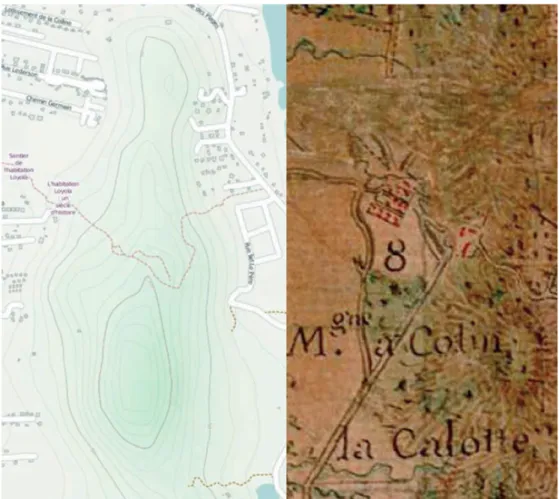
The Loyola Habitation is located in the municipality of Remire-Montjoly, French Guiana (Fig. 1). It disappeared from the Guyanese landscape until the discovery of the ruins (Fig. 1) in 1988 by Patrick Huard. It was over 1,000 hectares wide, with 500 slaves, and produced half of the cocoa and coffee in the colony. This singular establishment, both religious and slaver, began in 1668 and ended nearly a century later with the expulsion of the Jesuits from French Guiana in 1763. Its foundation aimed to get regular and substantial earnings to fund evangelical missions for the Indians. Since 1674, the Jesuits reorganized the place to turn it into a sugar plantation (Le Roux, 2006).
We have focused our work on this period. Indeed, this plantation included a wide spectrum of buildings (main house, chapel, blacksmith shop, pottery, windmill (Bigot, 2006), boiler, dryer, cemetery, coffee and indigo warehouses etc) and a considerable variety of vegetation.
fig. 1: Location of the site / Ruins of the Habitation 2. OBJECTIVES AND CONTRIBUTIONS
Archaeologists specialised in this site have done research since 1996. The needs of virtual reconstruction for an evaluation of the results, but also for an understanding, were identified in November 2013 during exchanges with computer scientists. These first needs resulted in a series of more detailed objectives.
The first goal was the creation of a 1:1 reconstruction of the 18th century sugar plantation. The 3D reconstruction was feasible thanks to the following elements:
• Documents provided by archaeologists who know the site perfectly (Fig. 2).
• One drawing (Fig. 2) among these documents made by a contemporary of the Habitation and others from a French comic book whose author had reflected upstream on the arrangement of the site (Pellerin, 2001).
• The West Digital Conservatory of Archaeological Heritage (Barreau, 2013), which allows 3D modeling of archaeological sites based on the information provided progressively by
archaeologists.
• The possibility of integrating such reconstructions within the Immersia virtual reality platform (Gaugne, 2014).
Besides reconstructing the appearance of the building at 1:1 scale, our next objective was to
reconstitute the natural environment of the site. We wanted to provide a geographical, ethological and botanical coherent restitution. To do that, we planned to work on sky positioning, spatial and time localized singing of birds and vegetation coherency.
The last step involved the exploration of possibilities for the user to interact with the environment. From these new possibilities of interaction and beyond visualization and immersion, the final objective was the creation of new tools for the work of archaeologists and historians.
fig. 2: Isometric view of the Loyola Habitation by Hebert (1730) / Restitution of the Jesuits' main house by Patrice Pellerin (2002)
3. WORK DESCRIPTION 3.1 Environmental restitution 3.1.1 3D restitutions
Documents provided by archaeologists to make the reconstruction were extremely diverse. Among them, there was firstly a very detailed book with many illustrations, including those mentioned above (Le Roux, 2009). A considerable amount of descriptive information was also available thanks to an excavation report, photos and videos made with a tablet. In these videos, the site is explained in situ by the archaeologist. More technically, we also had site and lines of communication maps, altitude surveys (Fig. 3), 3D animated renderings of similar buildings and a low-resolution point-cloud from an aerial photogrammetry. The 3D models, positioned and textured buildings were as follows:
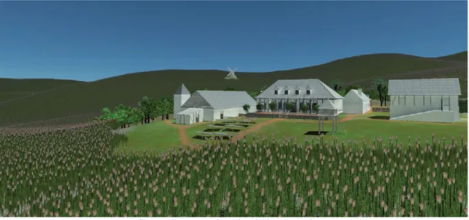
blacksmith shop, main house, sugar refinery, chapel, hospital, terraces, small houses of the quarter of the slaves and windmill (Fig. 4). Modeling was done at 1:1 scale and the “System Unit Setup” in 3DsMax was set to 1m. As in the software development process, we follow a top-down approach to have a first global understanding of the system. Thus we first focused on the outside of buildings.
fig. 3: IGN and Joseph-Charles Dessingy (1738-1785) map sections showing around the Habitation
fig. 4: 3D renderings (3Ds Max / VRay) of the main house, the windmill, a slave’s small house, the backside of the chapel
The reconstruction of the main house, focal point of the Habitation, consisted for instance in modeling a flattened clay platform, surrounded by dry stone walls which are composed of wattle and daub with wooden frames and a mud masonry joint filler. Large stone stairs provide access on three sides: front, rear and north facades etc.
3.1.2 Natural environment
For the natural environment, a 3.8x5.3kms field was first modeled thanks to altitude surveys, and both current and eighteenth-century maps. The vegetation in the seventeenth century differed from today's and, beyond plants used in the Habitation's activity (cacao tree, coffea, sugarcane and cotton plant), it is difficult to list other plants. However, a botanist stayed in the Habitation and listed some plants in a book (Fusée-Aublet, 1775).
As the vegetation targeted in the reconstruction was very specific, we modelled most of the plants: balsam of Peru, ceylon cinnamon tree, bloodwoodtree, campomanesia grandiflora, sandbox tree, cacao tree and black mangrove (Fig. 5). We also used 3D models of sugarcane plant, coffea and lemon tree from the 3D plants library (XfrogPlants, 2015).
fig. 5: 3D renderings of cacao tree, black mangrove and ceylon cinnamon tree 3.1.3 Human beings
There were a lot of human beings who carried out complex and various activities. Before
implementing them, it was necessary for us to establish a restitution protocol. We used the software Fuse 1.0 for 3D character creation, to assemble customizable body parts, clothing and textures together (Maher, 2014). Those characters were rigged with an online automatic model rigging service (Mixamo, 2015) to be exported into Unity (Fig. 6). The activities represented in the reconstitution will be defined in further work, from documents and information supplied by archaeologists.
fig. 6: Editable 3D slave’s body and face / rigged 3D slave’s body and skeleton / drawing of cassava pressing (Préfontaine, 1763)
3.2 Virtual reality implementation 3.2.1 Technical implementation
Unity game engine has been chosen for 3D simulation because of its simplicity. It is provided with an all-in-one editor which contains all our needs: terrain manager, 3D spatialized sound, skysphere and a good lighting renderer with fine overall performance. MiddleVR, a virtual reality plugin for Unity, manages all of our peripherals like flystick and DTrack tracking system and displays active stereoscopy on our 13 nodes cluster. The framerate of the simulation stays around 30 frames per second in our cave (Intel Xeon W3670, Quadro 5000) depending of the current user location. For the integration in Unity, 3D models of plants and buildings were converted to FBX format and sometimes simplified thanks to the Decimate Blender modifier.
3.2.2 Simulation of vegetation and animals
A semi-automatic approach allowed us to place vegetation. Coffee farming and forest trees were planted with “Unity terrain brush” in their specified area. The sugarcanes were automatically placed in the left area with a specified density and random range deviation (position, height, width) to simulate real world differences. There are around 787K trees in the current simulation with 782K sugarcanes and 5K coffees planted on a 0.8km! area. The distant area is simply textured. From a user's
perspective, only the nearest vegetation (" 0.1%) is displayed as mesh with dynamic shadow and wind effects. Thus, most of the trees are drawn as a billboard, which is a simple textured quad facing the user. These optimisations keep the frame rate reasonable despite the huge environment size (fig. 7).
fig. 7: 3D vegetation simulation overview
Archaeoacoustics is a vast and complex scientific discipline (eds. Scarre, 2006) (ed. Eneix, 2014). Concerning the study of the Habitation, human activity produced a sound environment that deserves to be studied. However, although we were fully aware of the rich fauna and flora of the site, we focused first on the sound of animals. Thanks to an ethologist specialist in the fauna of the region, we made 2 coherent lists of animals consistent with the vegetation described above. The first, consisting of 10 animals, concerns the sugar cane crops and open fields, and the second one, consisting of 16 animals, concerns the tree line near the buildings. We gathered samples of the sounds of animals, available on a website specialized on sharing sound samples (Xeno-canto Foundation, 2014), we structured the data so as to fit in the xml format (Fig. 8) and then we integrated it into de virtual reality module (Fig. 9).
fig. 8: Xml structure of animal sound data
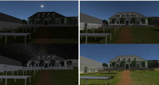
fig. 9: Spheres representing the sources of sound in the reconstruction 3.2.3 Time simulation
The evidence of a link between agriculture and exposition to sunlight made us work on the study of the evolution of sunlight throughout the day. For this matter, the position (latitude, longitude, altitude) of the site, associated with the NREL’s Solar and Moon Position Algorithm (SAMPA) (Reda, 2010) allowed us to calculate the solar and lunar zenith and azimuth angles, with uncertainties of +/- 0.0003 degrees for the Sun and +/- 0.003 degrees for the Moon, such as they were at that time. Therefore, knowing the positions of the moon, we could also use and position the textures of a starry sky thanks to the Tycho Catalog Skymap - Version 2.0 (NASA/Goddard Space Flight Center Scientific
Visualization Studio, 2009). The complete evolution of natural light of the Habitation on a 24 hours time frame was also reproduced (Fig. 10).
3.2.3 Immersion and interaction
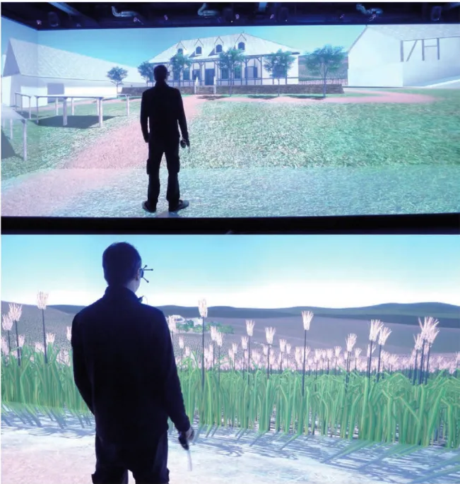
The simulation was deployed on an immersive facility, the Immersia platform!. This facility of the Irisa/Inria computer science laboratory is a large virtual-reality room dedicated to real-time, multimodal (vision, sound, haptic, BCI) and immersive interaction. It hosts experiments using interactive and collaborative virtual-reality applications that have multiple local or remote users. Images are rendered on four glass screens: a front one, two sides and a ground one. Dimensions are 10 m wide, 3 m deep and 3 m high. The number of pixels displayed is over 15 million. An infrared based tracking system enables real objects to be tracked within the scene, like the hand and the head of the user. This system with high-resolution rendering, active stereoscopy, tracking and homogeneous colouring delivers a visually realistic and immersive experience, which is particularly suitable for 1:1 rendering (Fig. 11). Spatial sound can be rendered by the speakers of the platform with 10.2 format or by a wireless stereo headset, more suited to binaural rendering. To check the dimensions in the immersive platform, a reference item on the ground level at parallax 0 has been measured.
fig. 11: Interactive simulation in Immersia """""""""""""""""""""""""""""""""""""""""""""""""""""""""""""
3.4 Interactivity
Inside the simulation, the user can interact with the virtual environment through a wand-like device integrating a little joystick and five buttons (Fig. 11). The device position and orientation is tracked with the infrared cameras.
The user can explore the virtual environment either by naturally walking within the limits of the facility, or moving the universe with the joystick. He can also teleport to predefined points of interest by pushing one button. Two other buttons are used to increase or decrease the time of the simulation and influencing the speed of the alternation of night and day.
fig. 12: Interactions with the simulation 4. DISCUSSION
Archaeological research on the French colonial America is a relatively nascent field. Since about three quarters of a century, especially from the 1960s, archaeologists began excavations in all regions of the Americas that could reveal traces of this French occupation. However, the results of these
archaeological researches too often remain confined to technical literature and reports, hard to access for the general public, and even for researchers (Moussette, 2013). The combined contributions of historical and archaeological sources provide a strong foundation for the restitution when, as here, there are not many remains. For example, the illustrations allow to guide very effectively the 3D modeling. Thus, we believe that supporting this research by 3D reconstitutions, virtual reality applications and associated thoughts, right from its early stages, can be a major issue for its development that requires summaries, understandings and explanations.
Concerning virtual reality, immersion within the platform led to apprehend circulation paths and overall visibility between buildings and the various fields surrounding the plantation. Apart from natural interactions with various elements of the environment, different methods of navigation have been implemented to enable archaeologists to move the entire site, which is extremely broad. They can currently do a scale-one immersion to experiment and rightfully check the visual and sound restitution of the site during one day, however without human beings and outside of the buildings. The next step should therefore consist in giving the opportunity to study the daily life of actors who made this site function.
5. CONCLUSION
The 3D reconstruction of buildings, vegetation, lighting and fauna sounds of the Habitation, integrated within a virtual reality platform, allow us to understand its layout, its access, its logic of evolution and to think about the production operated by several hundred people.
Many archaeological questions remain unanswered and we wish to imagine immersive working sessions with archaeologists and new VR interactive tools development. These would include:
• Automatic generation of study reports
• Dynamic positioning of bounding boxes marking the location of missing objects to model • Autonomous design of buildings’ structural system and vegetation areas
• Adapting these tools to other archaeological sites ACKNOWLEDGMENTS
We would like to especially thank Laurence Boissieux (INRIA), Loïc Rios and Mathilde Paradis (MJM Graphic Design school) for participating in outbuildings and plants 3D modeling. We would also like to thank Pierre Deleporte (CNRS), ethologist and specialist of the area's wildlife, for information about the animals living in this past vegetation.
REFERENCES
ARNALDI, B., GUITTON, P., FUCHS, P. & MOREAU, G. (2006). Le traité de la réalité virtuelle.
Volume 4, Volume 4,. Paris: École des mines de Paris.
BARREAU, J.-B., GAUGNE, R., BERNARD, Y., LE CLOIREC, G. & GOURANTON, V. (2013). The West Digital Conservatory of Archaelogical Heritage Project. In: DH. [Online]. 2013, France, pp. 1-8. Available from: https://hal.archives-ouvertes.fr/hal-00881775.
BARREAU, J.-B., GAUGNE, R., BERNARD, Y., LE CLOIREC, G. & GOURANTON, V. (2014). Virtual reality tools for the West Digital Conservatory of Archaeological Heritage. In: VRIC 2014,
ACM. [Online]. April 2014, New York, United States, pp. 1-4. Available from:
https://hal.archives-ouvertes.fr/hal-01003416.
BIGOT, V. (2006). L’habitation Loyola dite Moulin à Vent d’après les sources archivistiques : la transmission du passé colonial en Guyane française. In: L’histoire de la Guyane depuis les
civilisations amérindiennes: actes du colloque des 16, 17 et 18 novembre 2005, Cayenne. Espace
outre-mer. Matoury, Guyane: Ibis Rouge Editions, pp. 599-617.
CHRISTOU, C., ANGUS, C., LOSCOS, C., DETTORI, A. & ROUSSOU, M. (2006). A Versatile Large-scale Multimodal VR System for Cultural Heritage Visualization. In: Proceedings of the ACM
Symposium on Virtual Reality Software and Technology. VRST ’06. [Online]. 2006, New York, NY,
USA: ACM, pp. 133-140. Available from: http://doi.acm.org/10.1145/1180495.1180523.
CROTEAU, N. (2004). L’habitation de Loyola : un rare exemple de prospérité en Guyane Française.
ENEIX L. C. (ed.) (2014). Archaeoacoustics: The Archaeology of Sound ; Publication of Proceedings
from the 2014 Conference in Malta. Myakka City, FL: The OTS Foundation.
FORTE, M. (2011). Cyber-Archaeology: Notes on the simulation of the past. Virtual Archaeology
Review Vol. 2, Num. 4. pp. 7-18.
FUSÉE-AUBLET, J.-B.-C. (1775). Histoire des plantes de la Guiane Francoise: rangées suivant la
méthode sexuelle, avec plusieurs mémoires sur différens objects intéressans, relatifs à la culture & au commerce de la Guiane Françoise, & une notice des plantes de l’Isle-de-France. [Online].
Londres;Paris; P. F. Didot jeune. Available from:
http://www.biodiversitylibrary.org/bibliography/674. [Accessed: 25 June 2015].
GAUGNE, R., GOURANTON, V., DUMONT, G., CHAUFFAUT, A. & ARNALDI, B. (2014). Immersia, an open immersive infrastructure: doing archaeology in virtual reality. Archeologia e
Calcolatori, supplemento 5. pp. 1-10.
KOLLER, D., FRISCHER, B. & HUMPHREYS, G. (2010). Research Challenges for Digital Archives of 3D Cultural Heritage Models. J. Comput. Cult. Herit. 2 (3). pp. 7:1-7:17.
MAHER, K. (2014). Mixamo, a company offering tools for character creation, is getting ready for
GDC with new updates and a new pricing plan. [Online]. Available from:
http://gfxspeak.com/2014/03/12/mixamo-products-upgrades
MIXAMO (2015). Rig a character in the time it takes to get a cup of coffee. [Online]. Available from: https://www.mixamo.com/auto-rigger
MOUSSETTE, M. & WASELKOV, G.A. (2013). Archéologie de l’Amérique coloniale française. Réflexion. Montréal (Québec): Lévesque éditeur.
NASA/GODDARD SPACE FLIGHT CENTER SCIENTIFIC VISUALIZATION STUDIO (2012).
Deep Star Maps. [Online]. Available from: http://svs.gsfc.nasa.gov/cgi-bin/details.cgi?aid=3895.
PELLERIN, P. (2001). Le trésor du Mahury. [Marcinelle]; [Paris]: Dupuis.
PREFONTAINE DE, J.-A.-B. (1763). Maison rustique, à l'usage des habitans de la partie de la
France équinoxiale connue sous le nom de Cayenne. [Online]. Paris; Bauche. Available from:
https://books.google.fr/books?id=0SAaAAAAYAAJ.
PUJOL TOST, L. & SUREDA JUBANY, M. (2007). Vers une réalité virtuelle véritablement
interactive. In: Virtual Retrospect. November 2007, Pessac: Robert Vergnieux, Caroline Delevoie, pp. 77-81.
REDA, I. (2010). Solar Eclipse Monitoring for Solar Energy Applications Using the Solar and Moon
Position Algorithms. [Online]. Available from: http://www.osti.gov/servlets/purl/974908-APBEfU/.
[Accessed: 25 June 2015].
LE ROUX, Y. (2006). L’habitation Loyola à Rémire. L’archéologie coloniale pour l’histoire. In:
L’histoire de la Guyane depuis les civilisations amérindiennes: actes du colloque des 16, 17 et 18 novembre 2005, Cayenne. Espace outre-mer. Matoury, Guyane: Ibis Rouge Editions, pp. 599-617.
LE ROUX, Y., AUGER, R. & CAZELLES, N. (2009). Les jésuites et l’esclavage Loyola: l’habitation
des jésuites de Rémire en Guyane française. Québec: Presses de l’Université du Québec.
SCARRE, C. & LAWSON, G. (eds.) (2006). Archaeoacoustics. McDonald Institute monographs. Cambridge : Oakville, CT: McDonald Institute for Archaeological Research ; Distributed by the David Brown Book Co.
VERGNIEUX, R. (2011). Archaeological research and 3D models (restitution, validation and simulation). Virtual Archaeology Review Vol. 2, Num. 4. pp. 39-43.
XENO-CANTO FOUNDATION (2014). xeno-canto Sharing bird sounds from around the world [Online] Available from: http://www.xeno-canto.org/
XFROGPLANTS (2015). XfrogPlants - 3D Trees and 3D Plants [Online]. Available from: http://xfrog.com/category/xfrogplants.html