Philippe Hamman
Sociologie des espaces-frontières, 2013, 244 p.
Catherine Maurer et Astrid Starck-Adler (dir.)
L’Espace rhénan, pôle de savoirs, 2013, 446 p.
Christian Baechler
Clergé catholique et politique en Alsace 1871-1940, 2013, 252 p.
Denis Steinmetz (dir.)
La Coloration des façades en Europe, 2014, 256 p.
Henri Nonn
L’Alsace actuelle, 2015, 204 p.
Guillaume Christen et Philippe Hamman
Transition énergétique et inégalités environnementales. Énergies renouvelables et implications citoyennes en Alsace, 2015, 228 p. Histoire de Russie, avec sa partie politique, par Mr. Koch, Professeur à Strasbourg
suivie de la Constitution de l’empire de Russie,
édition établie, annotée et présentée
par Rodolphe Baudin et Wladimir Berelowitch, 2018, 326 p. Jean-Pierre Kintz
L’Alsace au XVIe siècle. Les hommes et leur espace de vie 1525-1618, 2018, 442 p.
Sustainability Research
in the Upper Rhine Region
Concepts and Case Studies
2 0 1 9
ISBN 978-2-86820-549-0
© 2019 Presses universitaires de Strasbourg 5 allée du général Rouvillois F-67083 STRASBOURG CEDEX
Maquette couverture : Michel Demange
et du FEDER – Fonds européen de développement régional.
Université
Research in France and Germany
Laurent S
CHMITT
a, Jean-Nicolas BEISEL
a,b, Frank PREUSSER
c,Carmen D
E
JONG
a, Karl M. WANTZEN
d, Valentin CHARDON
a,Cybill S
TAENTZEL
a, David ESCHBACH
a,e, Christian DAMM
f, Gilles RIXHON
a,b,Ferréol S
ALOMON
a, Rüdiger GLASER
c, Iso HIMMELSBACH
c, Yves MEINARD
g,Serge D
UMONT
a, Laurent HARDION
a, Jérôme HOUSSIER
a,h, Claire RAMBEAU
a,c,Stoil C
HAPKANSKI
a,i, Sebastian BRACKHANE
c*1. Introduction: Geographical setting and foci of the chapter
With a length of about 1,250 km and a drainage area of 185,000 km², the Rhine is the third largest European river system. It is often considered as the cul-tural and economic “spine” of Europe, due to its rich history, and the high con-centration of population and commercial enterprises located in proximity to the river in Switzerland, France, Germany, and the Netherlands (Figure 1, next page). For Switzerland, the Rhine is the only navigable connection to the world’s oceans. Geographically, the Rhine comprises five major sections: 1) The Alpine Rhine orig-inates from the confluence of Anterior Rhine and Posterior Rhine near Reichenau, Switzerland, and enters Lake Constance after 86 km; 2) The High Rhine flows from East to West and passes the Rhine Falls, the largest water fall of Europe; 3) The
* a University of Strasbourg / b French National School for Water and Environmental Engineering
(ENGEES) / c Albert-Ludwigs University Freiburg / d UNESCO Chair River Culture, University of
Tours / e Sorbonne University / f Karlsruhe Institute of Technology / g University Paris-Dauphine / h Institut national de recherches archéologiques préventives / i University Paris 1 Panthéon-Sorbonne.
202
Laur
ent Schmitt
Upper Rhine follows a major graben structure from Basel to Bingen; 4) The Middle Rhine, is characterised by a narrow valley incised into the Rhenish Massif between
Bingen and Bonn (i.e. known as the Romantic Rhine); and 5) The Lower Rhine, bypassing the German economic hotspots of Cologne, Düsseldorf, and the Ruhr district until it reaches its delta in the Netherlands.
The Upper Rhine Valley covers an area of about 300 km in length and 40 km in width (Figure 1). Here, the Rhine flows through a large geological rift, called the Upper Rhine Graben (URG), with a catchment of 62,967 km2 (Wantzen et al.,
2019). Along this reach, several tributaries such as the rivers Main and Neckar (Germany) and Ill (France) enter the Rhine, contributing to an increase in the mean inter-annual discharge from 1,050 to 1,590 m3.s-1. These tributaries decrease
the signature of the Alpine flow pulse because their hydrological regimes are plu-vionival or pluvial, but regular high flows remaining at the end of spring and the beginning of summer are typical for the entire Upper Rhine. Quaternary fluvial deposits generally reach a thickness of about 100 to 200 m (Bartz, 1974). These
Figure 1b: Downstream sectorization of the Upper Rhine channel pat-tern and its drastic simplification from the 18th century to today. The 10 power plants are also mentioned (source: L. Schmitt).
sediments host one of the largest groundwater reservoirs of Europe, of great impor-tance for the regional water supply. The URG is characterised by a confined con-tinental climate with mean annual temperatures of around 11°C. Situated in the slipstream of the Vosges/Pfälzerwald, the Upper Rhine valley features maximum precipitation limited to 500 mm–800 mm per year, with relatively high summer temperatures (mean temperature of July can exceed 20°C). Hydrological and geo-morphological dynamics, climate, groundwater, calcareous and relatively coarse sediments along the Rhine, and biogeographical factors are favourable ecological conditions providing an exceptional diversity of habitats and alluvial species in the Rhine hydrosystem and its alluvial plain (Carbiener, 1983), notably alluvial forests (Carbiener, 1970). Today, however, most of the original vegetation has disappeared due to extensive engineering works and intense agricultural activities.
For several years, an increasing number of scientific programs have been devel-oped, in some cases of interdisciplinary and transboundary character, with two dif-ferent foci: (i) investigations of the long-term (Holocene) dynamics of the entire alluvial plain, reconstructing past trajectories of River-Human interactions and establish guidelines for sustainable management, (ii) investigations of contempo-rary dynamics at the scale of Rhine main channel and associated flooding areas with side channels, in direct relation to the urgent need of flood retention and eco-logical improvement (Dister et al., 1990; Schmitt et al., 2012; Brackhane, Reif, 2018). Restoration actions are important because the Upper Rhine Valley supports valuable ecosystem services, which need to be preserved and restored further in the future. Their values lie mainly in the field of surface and groundwater resources, specific aquatic and alluvial biodiversity support, flood retention, summer temper-ature regulation, sediment transport, and human recreation (Schmitt, 2010).
This chapter provides an overview of recent research projects carried out along the Upper Rhine and its alluvial plain. It discusses future challenges and oppor-tunities to manage and restore floodplains and associated ecosystem services, and also indicates how sustainable management strategies for the Upper Rhine River could be developed successfully.
2. Holocene trajectories of the alluvial plain
The current alluvial plain of the Rhine originates from the end of the last gla-cial cycle, when the longitudinal profile of the Rhine adjusted in response to the evolution of several control factors: (i) the decrease of both liquid and solid flux due to Holocene warming with increased vegetation cover (Hirth, 1971); (ii) the trapping of sediment in Swiss lakes whose drainage surfaces correspond to 60% of the Rhine basin upstream of Basel (Walser, 1959), after their establishment and the retreat of alpine glaciers (Hirth, 1971); (iii) tectonic uplift upstream and downstream of Mulhouse (Nivière et al., 2006) and tectonic subsidence in the
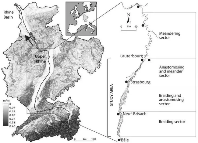
surroundings of Marckolsheim (Jung, Schlumberger, 1936; Illies, Greiner, 1979), as well as north of Strasbourg (Vogt, 1980). As a result, the longitudinal pro-file of the Rhine was incised on the Basel-Breisach and Strasbourg-Lauterbourg sections, and remained stable or rose slightly on the Breisach-Strasbourg section (Briquet, 1928; Carbiener, 1969, 1983; Figure 2). This differentiated evolution explains the longitudinal structure of both alluvial plain and channel pattern of the Upper Rhine before its channelization (Figures 1 and 2; Schmitt, 2010). Between Basel and Breisach, the Rhine originally exhibited a braiding channel pattern within a 2–4 km wide floodplain (slope ~0.1%). Between Breisach and Strasbourg the longitudinal slope decreases (~0.05–0.08%), and the huge width of the alluvial plain favoured a complex braiding-anastomosing channel pattern, whose maximum width attained over 8 km. In this reach, the Rhine moved east-wards during the Holocene (Schmitt et al., 2016; Figure 3, next page), as docu-mented by numerous palaeo-channels (Figure 4, page 223) which are currently often groundwater-feed channels representing a rich and original biodiversity of the alluvial plain (Carbiener, 1983; Trémolières et al., 2007; Schmitt et al., 2007, 2011). Some of these channels are as old as ~10,000 years (Schmitt et al., 2016). Progressive reduction in the valley slope from Strasbourg to Karlsruhe (~0.02– 0.04%) shifted the river into a meandering-anastomosing system. Downstream of Karlsruhe, it turned into a pure meandering system (Figure 2).
Figure 2:
a. Post-wurmian and Holocene evolution of the Rhine longitudinal profile from Basel to Maxau. b. Some hydromorphological characteristics of the fluvial hydrosystem according the Rhine longitudi-nal sectorization (Schmitt et al., 2016, modified).
Recent research in the braiding-anastomosing section aims at dating the Rhine and Ill dynamics through morpho-sedimentary and geochronological studies of 13 palaeo-channels (e.g. Figure 3). A systematic characterisation of all palaeo-chan-nels between Holtzwihr and Neuf-Brisach is the subject of an ongoing Ph.D. pro-ject (Abdulkarim, in preparation). This propro-ject also aims at providing guidelines for sustainable management of (i) groundwater feed rivers, such as the Orchbach, the Blind, and the Ischert (e.g. management of the sediment deposition and the current biodiversity by taking into account the trajectories of sedimentation and the biodiversity), and (ii) of the Ill river (e.g. management of the current avulsion tendency of this river). The alluvial plain of the meandering-anastomosing com-partment has been intensively studied in the last two years, aiming at reconstruct-ing the Holocene dynamics of the Rhine, understand past human-river interactions, and develop new sedimentological and geochronogical methods. Results may pro-vide useful insights for sustainable long-term management of the deposition of fine sediments in actively flooded areas of the Rhine floodplain, exemplified by the research completed on the Rohrschollen Island (Eschbach et al., 2018). In addition, the study of environmental DNA in river sediments may provide further information on past environments and dynamics of aquatic and riparian commu-nities during the Holocene (Thomsen, Willerslev, 2015).
Figure 3: Example of a Rhine palaeo-channel in which water runs still currently, forming a so-called “groundwater feed river”.
3. Environmental history of droughts since 1500
Understanding the extent to which the Upper Rhine basin is prone to climate change and droughts requires an interdisciplinary approach involving Geography, Climatology, Hydrology, History, Archaeology, Agricultural Sciences, Linguistics and Theology. The first international conference on “Adaptation and Resilience to Droughts: Historical Perspectives in Europe and beyond”, gathering scientists from 12 different countries, was held at the University of Strasbourg in collaboration with the University of Freiburg, Germany and the University of Bern, Switzerland (De Jong, 2017). Historical sources such as archives, chronicles and low water mark-ers such as hunger stones were used to reconstruct the magnitude and duration of droughts and low flows, as well as societal adaptation, essentially after
AD
1500. Comparison of the variability and spatial extent of droughts across Europe revealed that some drought events were more severe than today, for example that ofAD
1540 which extended for nearly 10 months (Wetter et al., 2014; Figure 8, page 226). Whereas droughts may be less severe nowadays, their impact on navigation, energy production, drinking water, tourism and forest fires has become more significant. A database on droughts named SEAL (Sécheresses d’Alsace-Lorraine) was created 1 incollaboration with the University of Freiburg (De Jong, 2017).
4. Sustainably restoring the Upper Rhine River:
A fourth challenging engineering phase
4.1. Past Rhine’s alterations motivating current restoration needs
Most large rivers worldwide have suffered the same types of degradations from strongly impacting human activities (Petts et al., 1989; Grill et al., 2019). The Upper Rhine River was particularly affected by its intensive use for navigation, agriculture, and by the production of hydroelectricity and the development of industrial activ-ities along the hydrosystem since about one century (Brauch, 1993). The main alterations date back to the 19th century, marking the beginning of three successive river management phases that drastically modified the functioning of the Upper Rhine: the so-called rectification, regularization and canalization. All three have progressively faceted the Upper Rhine as it is known today. Planned by the engineer Johann Gottfried Tulla, the rectification (1817–1876) stabilised the main channel between two artificial banks and limited the flooding area between two high-flow dikes. It aimed at controlling floods, fixing borders between France and Germany, developing agriculture and forest, and improving human health by reducing mos-quito habitats (Tulla, 1825). It strongly impacted aquatic and riverine habitats
and thereby biodiversity, and turned the Rhine from a “wild” river to a semi-con-trolled hydrosystem, with huge alteration of hydromorphological functions (Diaz-Redondo et al., 2017). The main channel was narrowed down from about 1,000 m to 200–250 m and many meander bends were artificially cut off, resulting in a slope increase of 14% from Basel to Lauterbourg (Gallusser, Schencker, 1992). The riverbed incised up to seven metres upstream Breisach (Gallusser, Schencker, 1992; Arnaud et al., 2019), resulting in the formation of an armour layer, which remains partly dynamic during high flows (Chardon et al., 2018). It also increased the surface of outcropping/protruding bedrock (e.g. the so-called “barre d’Istein/
Isteiner Klotz”) within the riverbed, and disconnected the latter from its floodplain
and lateral channels (Arnaud et al., 2015; Arnaud et al., 2019). Downstream of Breisach, the corrected channel incised about one metre, except from Breisach to Strasbourg, where the longitudinal profile was almost stable (Gallusser, Schencker, 1992). The regularization (1930–1962) involved the construction of in-channel alternate groyne fields to improve navigation, inducing an additional one metre of incision. The canalization (1932–1977), as stipulated in the “Peace Treaty of
Versailles” of 1919, led to the construction of ten hydroelectric power plants linked
to dams and locks. This resulted in the subdivision of the Upper Rhine into three reaches, matching the aforementioned hydromorphological longitudinal subdivi-sion. From upstream to downstream, they are: (i) the 51 km-long braiding reach from Kembs to Breisach, by-passed by the “Grand Canal d’Alsace” (GCA) on the French side (with four power plants); (ii) the braiding-anastomosing reach from Breisach to Strasbourg with four festoons (short by-passes constituted by an artifi-cial canal feeding four power plants); and (iii) the meandering-anastomosing reach from Strasbourg to Iffezheim where the riverbed was fully covered in concrete (two power plants). Main impacts of the canalization are the loss of both biological and sedimentary longitudinal connectivity and the drastic decline of lateral connectiv-ity. In this respect, a total of ~130 km2 of floodplain surface, formerly storing flood
water, was suppressed and thereby increased the flood risk downstream Iffezheim (CHR/KHR, 1977; Dister et al., 1990). A majority of lateral channels also became disconnected, notably leading to profound land-use changes such as the reduction of the alluvial forest ecosystem (the temporal trajectory of the Rhine channel pat-tern is illustrated by Figure 5 (see page 224), which concerns the surroundings of Strasbourg). Remaining forests are also gradually transformed into hardwood for-est (Carbiener, 1983). In the Old Rhine along the first reach (Kembs to Breisach), the hydrological regime was strongly modified (Tricart, Bravard, 1991): the water supply only represents ~10% of the mean inter-annual flow of the Rhine (Staentzel
et al., 2018a). This minimum flow release was even much lower before 2010
(~2.5% of the mean inter-annual flow), a situation currently occurring along the four reaches of the Old Rhine downstream of Breisach. During flood events, when the GCA capacity of 1,400 m3.s-1 (from Kembs to Breisach) is exceeded, excess
into the Old Rhine are less frequent and shorter compared with the situation before canalization (Arnaud et al., 2015). The successive dams generated a stepped— instead of a gradual sloping—longitudinal profile. The successive reaches consti-tuting these steps have homogeneous artificial banks and flow conditions with few hydromorphological macro-forms, and are prone to warming up because of sun-light, which is problematic during summer heatwaves. The five by-passed reaches of the Old Rhine, together with scarce areas of former natural floodplain (includ-ing four artificial islands shaped by festoons), are the skinny legacy of the original natural environment. Since the 1980s, there is increasing political consensus to pre-serve still-functional habitats and to restore intensively altered ones (Schmitt et al., 2012). However, the degree of damage caused to the environment requires well-tai-lored restoration approaches; there is no “one-fits-all” solution and the restoration options are not the same in the different longitudinal sections of the hydrosystem.
4.2. Feedback on restoration actions:
An experimental field for ambitious unprecedented restoration programs
A wide variety of restoration actions has already been carried out along the Upper Rhine, including construction of fish passes, side channel reconnection (with in some cases channel unclogging) or creation, increase of instream flow releases, gravel artificial supplies, controlled bank re-erosion, removal of bank fix-ation (without recover of bank erosion), rehabilitfix-ation of specific habitats, and reintroduction of species (Schmitt et al., 2012). Schmitt and Beisel (2015) inven-toried more than 130 restoration actions since the 1980s along the Upper Rhine. These efforts have intensified after the Sandoz chemical accident in 1986, and the assessment of the Water Framework Directive of 2000 (Wantzen et al., 2019), but their extent and functional impact remain relatively limited for the moment. Temporal evolution of restorations is strongly dependent to the types of restora-tions and the concerned longitudinal geomorphological secrestora-tions of the Upper Rhine (Figure 6, see page 211).4.2.1 Actions to restore floodplain environments and their side channels An important way to restore former floodplains is to re-establish a flooding regime as close to natural conditions as possible by reconnecting them to the river main channel, i.e., to re-establish the natural flood pulse as the most important driver of ecological processes and of biotic assemblages (Junk, Wantzen, 2004). Dike relocations, i.e. construction of a new dike behind an existing dike with later removal of the old dike to expose additional former floodplain area to the river’s flooding regime, proved to be an efficient measure in terms of flood peak reduction (Promny et al., 2014; Alexy, 2013), as well as for ecological restora-tion (Damm, 2016). On the Upper Rhine, focus is more predominantly on flood
protection using dike-contained former floodplain areas with controlled flood-gates which are called “polder”. Eighteen such polders have been constructed or are planned, two of which are in France, 10 in Baden-Württemberg and 6 in Rhineland-Palatinate. Other flood protection measures consist of floodplain lowering along the German side of the most upstream Old Rhine (Brendel, Pfarr, 2017), and operational changes for power plants and closing two agricul-tural dams (Wantzen et al., 2019). All measures belong to a program (Integrated Rhine Programme) committed to restore pre-canalization levels of flood protec-tion (Commission Permanente, 2016), by retaining 272.6 million of m3 for a
200-year flood. In order to reduce detrimental effects on biota notably caused by the rare use of polders (floods would only occur once a year, or even less; Dister
et al., 1990) leading to a lack of flood adaptation, ecological improvements can be
attained by frequent artificial flooding of the polder area, called “adaptive flood-ing” or “ecological floodflood-ing”. The German polder Altenheim near Strasbourg is presently the only one with a significant number of artificial floods since 1987 and a well-developed monitoring program (Pfarr, 2014; Brendel, Pfarr, 2017). Both such measures have been carried out for the first time in France (2004) at the “Erstein polder” (Schmitt et al., 2008). A process-oriented functional approach focussing on floodplain restoration and considering the natural dynamic charac-ter of the Upper Rhine is currently being developed near Rastatt in the free-flow-ing section just below the most downstream power plant of Iffezheim. The aim is to maximize historic hydromorphological processes to shape the floodplain land-scape (Diaz-Redondo et al., 2018), diverting significant discharges into remaining side channels of a 8.5 km² protected area in accordance with the intense naviga-tion use on the main channel. Hydronumeric modelling of flow and sediment transport is currently implemented in order to shape and optimize efficient meas-ures. Despite surrounding land uses posing a considerable set of constraints, the project aims to achieve significant ecological effects implementing unprecedented dimensions of reconnection measures.
More recently, the Rohrschollen Island near Strasbourg was restored notably by excavating of a new channel in the floodplain. This artificial island is delimited by the festoon layout, with the Old Rhine at its East margin and the canalized Rhine supplying water to the power plant at its West margin. The city of Strasbourg led a restoration action (2010–2014) to recover typical alluvial habitats, processes and biodiversity (such as pioneer and hygrophilous tree species) by restoring dynamic floods, and activating morphodynamics and bedload transport. A new 1 km-long channel was dug to re-establish water flow in a former channel which had par-tially filled up since Tulla’s rectification (Eschbach et al., 2018). A large floodgate at the southern tip of the island (upstream) allows water inputs ranging from 2 to 80 m3.s-1 (depending on the Rhine discharge: Q < or > 1,550 m3.s-1, respectively).
Ecological floods in the island are permitted by the 20 m3.s-1 maximum bankfull
activates surface water–groundwater exchange, recognized as a key-process in aquatic ecosystem functioning (Boulton, Hancock, 2006), of growing importance in the context of climate change. Infrared remote sensing allowed to determine its relationship to formation of riffles and bars directly induced by restoration (Eschbach et al., 2017). Eschbach et al. (2018) also highlighted that past engi-neering works at the same location intensified deposition of Zn-contaminated fine sediments in disconnected channels. In contrast, the other floodplain areas recorded lower deposition rates by quasi-unpolluted sediments. There is thus a potential risk that side channel restorations remove fine and polluted sediments by reactivating erosion/deposition processes. Floodplain surfaces between discon-nected channels generally show thin layers of fine sediments and consequently appear more relevant than side channels for restoration purposes. Following the restoration example of the Rohrschollen, managers should consider excavating new channels in areas with high restoration potential such as these. This may even allow spontaneous formation of side channels into floodplains by dynamic floods (Eschbach et al., 2018).
Figure 6: Temporal pattern of the Upper Rhine restoration projects classified by (left) main cate-gories and by (right) the Rhine’s longitudinal sectors. Data by the REX project (“Retour d’expéri-ence des projets de restauration écologique le long de l’axe rhénan”, ENGEES).
4.2.2 Along the Old Rhine: An innovative action of controlled bank re-erosion Another innovative restoration action was conducted in 2013 by EDF (Électricité
de France), in parallel to two actions of gravel augmentation (Chardon et al., 2018),
namely, a controlled bank re-erosion on the left bank of the Old Rhine near the village of Ottmarsheim (Aelbrecht et al., 2014; Pinte et al., 2015). It consisted in the removal of bank fixation and of three old groynes, and in the construction of two in-channel transverse artificial groynes, to (i) induce lateral erosion and feed the main channel in sediments, and (ii) diversify the fluvial mosaic (Staentzel et al., 2018b, 2018c; Figure 9, see page 226). It has been monitored for now five years by an interdisciplinary approach combining both hydromorphological and ecological approaches (Figure 7, see page 225). New fluvial forms appeared rapidly follow-ing the deposit of fine substrates comfollow-ing from the bank erosion but also from the main channel, upstream (Chardon et al., 2018), and new mesohabitats added up to those already in place (Figure 7, page 225; Staentzel et al., 2019). Sedimentation habitats harboured a specific fauna that was not observed elsewhere, and thus con-tributed to an increase in the taxonomic and functional richness of the entire site (Staentzel et al., 2019). Functional measurements have confirmed that newly created habitats in the restored section facilitated the establishment of particular profiles of burrowing species, such as Odonata whose ecological requirements are targeted to fine-grained habitats and slow-current velocities. Since this restoration action, their life-cycle completion has also been improved by a softer water-riverside interface (Staentzel et al., 2019). Results showed that sustainability of restoration effects was strongly dependent of the lifetime of the two artificial groynes because they influ-ence strongly the local flow conditions. Moreover, sediment supply from the bank re-erosion was limited due to the fact that old embankments were deeply buried into the bank. Other results showed that three years after the restoration, 7.3% of the open water area with filamentous algae was colonized by aquatic vegetation previously absent from the central channel of the Old Rhine (Figure 7, page 225; Staentzel et al., 2018b). The main feedback of this action is that implementation of groynes combined with bank fixation removal, a type of action never used on large rivers before, was a decisive technical option to diversify alluvial habitats and gain in biodiversity. This argues in favour of implementing this technical itinerary in similar environments to diversify alluvial habitats in the future.
4.3. At the bedside of a hotspot of biodiversity
In spite of a large number of restoration projects in the Upper Rhine floodplain, only few restored sites were monitored to evaluate if the restoration objectives have been reached (Schmitt et al., 2012; Schmitt, Beisel, 2015). Much of current mon-itoring focused on few target species assemblages, without accounting for abiotic driving factors, such as hydrology and morphodynamics. An international con-ference held in Strasbourg in 2017 (Renaturierungsmaßnahmen für ein nachhaltiges
Habitat Management am Oberrhein—ein Erfahrungsaustausch. Restaurer le Rhin Supérieur au service d’une gestion durable: retours d’expérience—Restoring the Upper Rhine for sustainable management: feedback, Strasbourg, 11–12 May 2017),
organ-ized in the context of the Sustainability Cluster, concluded that shared abiotic and biotic metrics are needed to monitor restoration actions. Another insight from this conference was that the large number of actors involved in restoration activities increase the need to gain a global overview of all restoration efforts.
An international observatory for the restoration of the Upper Rhine was set up in order to (i) promote an international view of the restoration of the Rhine River and its floodplain, (ii) support comparison of monitored results and creation of a shared database, (iii) better accumulate and exchange experiences to improve already restored sites, and (iv) to make future projects more efficient in restora-tion of more effective and sustainable fluvial processes (Schmitt, Beisel, 2015). For example, restoration measures in the Erstein polder, which included re-flooding and channel reconnection, involved interdisciplinary scientific monitoring over a relatively long period of six years (Trémolières et al., 2008; Schmitt et al., 2009). On this basis, improvements in restoration approaches are currently considered. Preliminary outcomes of this observatory show that while the first restoration pro-jects were small-scaled and unmonitored, more recent propro-jects are generally more ambitious in terms of spatial extent and natural processes which are restored, and better monitored. Complementary restoration of flood retention and ecological function on the Upper Rhine currently in progress has shown positive results, but much remains to be done.
Besides hydromorphological restorations, actions must namely also concern water quality, which is still affected by micropollutants (Mani et al., 2015), and proliferation of invasive species. The Rhine is well-known as a highway for invad-ers, with a gate in the Upper Rhine that allows them to enter in French hydrosys-tems (Kalchhauser et al., 2013; Beisel et al., 2017). Specifically, the Upper Rhine serves as a hub for upstream and downstream colonization by pontocaspian spe-cies (Wantzen et al., 2019). An apparent paradox is that the restoration of ecolog-ical corridors is essential for local species to complete their life cycle and respond to climate change, but that it may also favour successful spread of exotic species. These can damage local biodiversity and delay or obscure the effects of restoration. Restoration actions must take this into account and best promote biological traits of native species through appropriate technical itineraries. Apart from re-estab-lishing environmental flows, the flood pulse, and natural hydro-sedimentological dynamics, the management of water temperature (heat waves, heat islands, resid-ual flow) also represents a crucial issue to control invaders in the case of the Rhine River (Hesselschwerdt, Wantzen, 2018).
Finally, due to the relatively high sedimentation rate of ~1 cm.y-1 in flooded
areas (Frings et al., 2011), restoration of floodplain habitats is non-sustainable if active morphodynamics are excluded. Restoring hydromorphological dynamics
in the Rhine River presents the global problem of trying “to make three ome-lettes with just one egg”: hydropower production and flood control measurements do not allow sufficient stream power to turn sediments over, or to uproot pion-ier vegetation, while the amount of available sediments is strictly reduced due to retention in barrages, and because of lacking floodplains as stocks for erodable sediments (Wantzen, Rodrigues, in press). Nevertheless, sustainability of resto-ration actions is a necessity due to their high costs (Schmitt et al., 2018). Thus, restoration actions should try to establish sufficient water fluxes to allow recovery of coarse sediments, a texture which is currently lacking, but was much more fre-quent in the past (Dister et al., 1990; Eschbach et al., 2018). To reach this goal, and to minimize risks, restoration projects should be based on numerical (and even physical) modelling approaches. For instance, in addition to the modelling study downstream Iffezheim mentioned above (Diaz-Redondo et al., 2018), 2D hydraulic and morpho-sedimentary modelling is in progress on the Rohrschollen Island, and a 1D–2D hydraulic modelling is carried out on the most upstream Old Rhine (Chardon et al., 2018). Both aim building for managers several man-agement scenarios.
5. Conclusion and outlook
This chapter has reviewed some examples of recent research programs aiming at a better understanding of the temporal trajectory of the Upper Rhine at differ-ent spatio-temporal scales: the whole alluvial plain during the Holocene, and the “current” fluvial hydrosystem during the two last centuries, especially during the last three decades during which many restoration projects have taken place.
Interdisciplinary French-German research on Holocene river dynamics already provided significant results (Schmitt et al., 2016) and will continue in the Drusenheim/Rheinmünster to Seltz/Rastatt and North Colmar to Breisach areas (Abdulkarim, in preparation). Innovative operational recommendations will be deduced from these investigations. This will promote sustainable management of groundwater-feed rivers (management of biodiversity and clogging), the Ill River (management of the current avulsion tendency) and the Rhine hydrosystem (management of flooding compartments and side channels in terms of long-term sedimentation). Droughts not only affect land use and stream discharge but also groundwater. In this context, a Ph.D. thesis has been started on “The resilience of Alsatian aquifer to climate and anthropogenic change” (Labarchède, in preparation).
The Rhine may serve as a positive and a negative example for sustainable river management at the same time. In terms of chemical water quality management, significant improvements have been recorded (albeit many substances still cause concern), and this should be highlighted. In terms of management and re-estab-lishment of physical habitats and their dynamics as a condition sine qua non for the
sustainability of its biodiversity, however, there are still huge gaps, due to the fact that (i) restoration projects have rarely been planned with a joint strategical baseline within or between administrative units, (ii) the establishment of networks between habitats (both, aquatic and terrestrial) is still far from satisfactory, and (iii) habitat dynamics cannot be established without sufficient water, sediments, and floodplain space (Wantzen et al., 2019). In the context of biodiversity, sustainability does not mean “maintenance of the status quo” but rather “maintenance of the evolution-ary potential of the biotic populations”. This depends on sufficiently large and well-connected habitats to avoid genetical bottlenecks and sufficiently near-natural environmental conditions and dynamics to maintain stabilizing selective processes. Considering dwindling freshwater biodiversity, with a global average loss of 83% in the past 25 years (WWF, 2018), the coincidence of biological and cultural diversity reduction (Wantzen et al., 2016) and the fact that the Rhine belongs to the most fragmented and otherwise modified rivers worldwide (Grill et al., 2019), there is still room for further improvements. The study of past Rhine restorations may help stakeholders to strengthen efficiency and sustainability of future restoration actions. The philosophy of restoration action is to intervene once so as to re-engage natural processes. Ideally, actions consist in removing anthropic pressure and then letting the natural system evolve under the influence of natural processes. However, in numerous cases, restorations require (sometimes important) ecological engineer-ing works, such as construction of floodgates and fish passes, removal and/or con-struction of dikes, channel excavation, and removal of bank protection. Whether a larger restoration project concerning the Old Rhine including both Taubergießen (German) and Rhinau (French) can be realized in the future is currently discussed by managers. Other options are also currently discussed, such as restoration sce-narii in the Robertsau forest north of Strasbourg. Concerning monitoring activity, biological monitoring in the Old Rhine between Kembs and Breisach will con-tinue and hopefully be extended to geomorphological indicators. Further scien-tific monitoring should also be planned in the Rohrschollen natural reserve near Strasbourg. More generally, all restoration actions should ideally be preceded and followed by an appropriate monitoring program, over short to middle term, to assess whether objectives are achieved and to produce feedback and new knowledge to improve efficiency and sustainability of subsequent restorations (Schmitt et al., 2012; Schmitt, Beisel, 2015). Towards this objective, scientists and stakehold-ers should also work together in an international network bringing together their restoration experiences and data, as recommended by Schmitt et al. (2012). The success of such knowledge-sharing platforms also hinges upon cogent choices of indicators and monitoring methodologies, shared among all participants—which means, among other requirements, that they should be both scientifically rigor-ous and operationally implementable by managers. This, in turn, necessitates that national and European institutions devote important funds for elaboration and implementation of monitoring schemes.
Last but not least, two further and emerging topics are also currently devel-oped: (i) the geo-history of water’s pollution caused by industries and the imple-mentation of policies in reaction of these contaminations in the Upper Rhine river (Ly Keng, in preparation) and the subsequent pollution of fine sediments depos-ited in the floodplain, from Breisach to Strasbourg, which can impair restoration as highlighted by Eschbach et al. (2018); (ii) the study of the restoration govern-ance by stakeholders, aiming to produce a new tool for participatory and adaptive management (Osorio, in preparation).
In conclusion, the number of research projects on the Upper Rhine River has increased remarkably in the past few years, with several collaborative research pro-jects involving scientists from France, Germany and Switzerland. In the future, it will be important to further strengthen interdisciplinary and multilateral collabo-ration in the Upper Rhine valley to tackle challenges such as sustainable manage-ment of ecosystem services of the Rhine River and its alluvial plain, climate change, invasive species and biodiversity loss. Associated projects, which may notably be based on systemic modelling, should not only be limited to scientists, but rather should integrate all relevant stakeholders and the public, to develop sustainable management regimes for the Upper Rhine and its alluvial plain. Consequently, enhancing the awareness of the public and stakeholders to ecosystem services of the Rhine, its alluvial plain and groundwater, is crucial. This is currently achieved, for example, by the broadcasting of an unprecedented pedagogic and aesthetic Franco-German documentary entitled “The Invisible River” (Dumont, 2019), which has a huge positive impact.
Acknowledgements
This publication is notably a result of the think tank “Rhine River Hydrosystems: Past, Present, Future”, which was developed in the frame of the Upper Rhine Cluster for Sustainability Research. Major funding for the think tank’s activities was provided by the Wassernetzwerk Baden-Württemberg. The think tank has also been developed under the auspices of the UNESCO Chair “River Culture/Fleuves et Patrimoine” granted to Karl M. Wantzen (2014–2022). We thank the com-pany “La Ballastière HELMBACHER/Sablière HELMBACHER” for its support. The research programmes mentioned in this chapter are as follows: CNRS-EDF partnership agreement “Management of the Old Rhine River geomorphology” (2014–2017; coord.: L. Schmitt); IDEX Strasbourg–CNRS Post-doc fellow-ship “Approche transfrontalière de paléo-dynamique fluviale et de géoarchéolo-gie alluviale du Rhin Supérieur entre Drusenheim/Rheinmünster et Seltz/Rastatt” (2017–2019; coord.: L. Schmitt); Research Innovation Fund of the University of Freiburg “Across the river: Past river dynamics and landscapes in the Upper Rhine Graben—a trans-border approach” (2015; coord.: C. Rambeau and S. Brackhane); REX project “Retour d’expérience des projets de restauration écologique le long de
l’axe rhénan”, French National School for Water and Environmental Engineering (ENGEES), Strasbourg (2015–2017; coord.: J.-N. Beisel and L. Schmitt); OHM Fessenheim (since 2018; coord.: D. Badariotti); IDEX Strasbourg–CNRS inter-disciplinary “Juxta Rhenum” project (2017–2019; coord.: C. Roy); French-German ANR–DFG TRANSRISK2 project “Gestion transnationale des risques
d’inondations dans le bassin versant du Rhin. Une démarche historico-progressive” (ANR-07-FRAL-025; 2014–2018; coord.: B. Martin); PCR (Projet Collectif de Recherche) “Paysage et peuplement du secteur ello-rhénan (Région Alsace), entre forçage environnemental et contrôle humain. Approche intégrée du Néolithique au Moyen Âge” (2007–2008; coord.: E. Boës); PCR “Du Rhin archéologique au Rhin historique: les hommes et le fleuve” (2014–2015; coord.: M. Lasserre, G. Triantafillidis, T. Logel, L. Schmitt); Fundação para a Ciência e a Tecnologia, Grant/Award Number: SFRH/BD/52513/2014; French CNRS research pro-gram ARTEMIS. Several propro-grams and organisms supported the researches undertaken on the Rohrschollen Island (2013–2017): European Community (LIFE08 NAT/F/00471; coord.: F. Lonchampt), the City of Strasbourg, the University of Strasbourg (IDEX-CNRS Interdisciplinar MODELROH project; coord.: B. Martin), the French National Center for Scientific Research (CNRS), the ZAEU (Zone Atelier Environnementale Urbaine—LTER), the Water Rhine-Meuse Agency, the DREAL Grand Est, the Région Alsace, the Département du Bas-Rhin and the company Électricité de France.
References
A
bdulkarim
Mubarak, ongoing, Holocene Fluvial Paleo-Dynamics in the FrenchRhine Alluvial Plain, from Hotzwihr to Neuf-Brisach, Ph.D. Dissertation in
Geology, Albert-Ludwigs University of Freiburg.
A
elbrecht
Denis et al., 2014, “Morphodynamics Restoration of the Old Rhine through Controlled Bank Erosion: Concept, Laboratory Modeling, Field Tes-ting and First Results on a Pilot Site”, Proceedings of the InternationalConfe-rence on Fluvial Hydraulics, RiverFlow 2014: 2397–2403.
A
lexy
Matthias, 2013, “Numerische Modelluntersuchungen zu den Auswir-kungen der Deichrückverlegung Lenzen und von geplanten Vorlandanpflan-zungen”, BAW Mitteilungen, 97: 73–98.A
rnaud
Fanny et al., 2015, “Historical Geomorphic Analysis (1932–2011) of a By-passed River Reach in Process-based Restoration Perspectives: the Old Rhine Downstream of the Kembs Diversion Dam (France, Germany)”,Geo-morphology, 236: 163–177.
B
artz
J., 1974, “Die Mächtigkeit des Quartärs im Oberrheingraben”, in Illies
Inter-Union-Commission on Geodynamics”, Scientific Report, 8, Schweitzerbart (Stuttgart): 78–87.
B
eisel
Jean-Nicolas, Peltre
Marie-Christine, Kaldonski
Nicolas, Hermann
Agnès, M
uller
Serge, 2017, “Spatiotemporal Trends for 479 Exotic Species in French Freshwater Ecosystems: Where are We now?”, Hydrobiologia, 785 (1): 293–305.B
oulton
Andrew J., Hancock
Philippe J., 2006, “Rivers as Groundwater-Dependent Ecosystems: a Review of Degrees of Dependency, Riverine Processes and Management Implications”, Australian Journal of Botany, 54: 133–144. Brackhane
Stephan, Reif
Albert, 2018, “Zurück zum wilden Rhein?Auenrena-turierung und Naturschutz am Oberrhein”, Freiburger Universitätsblätter, 222 (4): 37–49.
B
rauch
H.-J.,1993, “Pesticides in the River Rhine”, Acta Hydrochimica etHydro-biologica, 21 (3): 137–144.
B
rendel
Manfred, Pfarr
Ulrike, 2017, “Integriertes Rheinprogramm: viel Öko-logie im Hochwasserschutz”, Jahrbuch für Naturschutz und Landschaftspflege, 61: 128–133.B
riquet
Abel, 1928, “La terrasse à berge haute du Rhin moyen”, Bulletin duService de la Carte Géologique d’Alsace et de Lorraine, 1: 263–268.
C
arbiener
Roland, 1969, “Le Ried Centre Alsace. Écologie d’un paysage”,Bul-letin de la Société Industrielle de Mulhouse, 1: 15–44.
C
arbiener
Roland, 1970, “Un exemple de type forestier exceptionnel pour l’Europe occidentale: la forêt du lit majeur du Rhin au niveau du fossé rhénan (Fraxino-Ulmetum). Intérêt écologique et biogéographique. Comparaison à d’autres forêts thermophiles”, Vegetatio, 20: 96–148.C
arbiener
Roland, 1983, “Le grand Ried Central d’Alsace: écologie et évolution d’une zone humide d’origine fluviale rhénane”, Bulletin d’Écologie, 14: 249–277. CHR/KHR,
1977, “Le bassin du Rhin”. Monographie, Commission Internationalede l’Hydrologie du Bassin du Rhin (KHR), DenHaag, Netherlands.
C
hardon
Valentin et al., 2018, “Geomorphic Effects of Gravel Augmentation on the Old Rhine River Downstream from the Kembs Dam (France, Germany)”,River Flow 2018: 1–8.
C
ommission
Permanente,
2016, “Démonstration de l’efficacité des mesures de rétention des crues du Rhin Supérieur entre Bâle et Worms”, Rapport inter-médiaire, automne 2016, Convention du 4 juillet 1969 entre la République française et la République fédérale d’Allemagne sur l’aménagement du Rhin entre Strasbourg/Kehl et Lauterbourg/Neuburgweier: 24.D
amm
Christian, 2016, “Naturschutzgroßprojekt Lenzener Elbtalaue – Umsetzung und Erfahrungen eines Pilotprojekts”, Natur und Landschaft, 91 (8): 359–365.D
e
Jong
Carmen (ed.), 2017, “Adaptation and Resilience to Droughts: Historical Perspectives in Europe and Beyond”, International Conference Proceedings, University of Strasbourg: 34.D
iaz‐
Redondo
Maria, Egger
Gregory, Marchamalo
Miguel, Hohensinner
Stefan, D
ister
Emil,
2017, “Benchmarking Fluvial Dynamics for Process‐ based River Restoration: The Upper Rhine River (1816–2014)”, RiverResearch and Applications, 33: 403–414.
D
iaz
-Redondo
Maria et al., 2018, “Targeting Lateral Connectivity and Mor-phodynamics in a Large River‐Floodplain System: The Upper Rhine River”,River Research and Applications, 34 (4): 1–11.
D
ister
Emil, Gomer
Dieter, Obrdlik
Peter, Petermann
Peter, Schneider,
Erika, 1990, “Water Management and Ecological Perspectives of the Upper Rhine’s Floodplains”, Regulated Rivers: Research & Management, 5: 1–15. D
umont
Serge (ed.), 2019, “The invisible River”, Documentary directed bySerge Dumont, Seppia film, co-producted by Läengengrad Filmproduktion, France Télévisions, SWR, WDR, in collaboration with Arte, 44 minutes. E
schbach
David et al., 2017, “Thermal-Infrared Remote Sensing of SurfaceWater-Groundwater Exchanges in a Restored Anastomosing Channel (Upper Rhine River, France)”, Hydrological Processes, 31: 1113–1124.
E
schbach
David et al., 2018, “Long-Term Temporal Trajectories to Enhance Restoration Efficiency and Sustainability on Large Rivers: an Interdisciplinary Study”, Hydrology and Earth System Sciences, 22: 1–21.F
rings
Roy M., Gehres
Nicole, Promny
Markus, Middelkoop
Hans, Schüt-trumpf
Holger, Vollmer
Stefan, 2014, “Today’s Sediment Budget of the Rhine River Channel, Focusing on the Upper Rhine Graben and Rhenish Massif”, Geomorphology, 204: 573–587.G
alusser
Werner, Schenker
André, 1992, Die Auen am Oberrhein – Les zonesalluviales du Rhin supérieur, Basel, Birkhäuser.
G
rill
Günther et al., 2019, “Mapping the World’s Free-Flowing Rivers”, Nature, 569: 215–221.H
esselschwerdt
John, Wantzen
Karl M., 2018, “Global Heating Threatens Thermal Barriers Against Invasive Species in Freshwater Ecosystems—A Study from Lake Constance”, Science of the Total Environment, 645: 44–50.H
irth
Claudine, 1971, “Éléments d’explication à la formation des Rieds ello-rhénans au nord de Colmar du début du post-glaciaire à la canalisation du Rhin auXIX
e siècle”, Bulletin de la Société d’Histoire Naturelle de Colmar, 54 :21–44.
I
llies
Joachim, Greiner
Gertrud, 1979, “Holocene Movements and State of Stress in the Rhinegraben Rift System”, Tectonophysics, 52: 349–359.J
ung
Jean, Schlumberger
C., Schlumberger
M., 1936, “Soulèvement des alluvions du Rhin par des intrusions salines diapirs de Haute-Alsace. Défor-mation de la surface de la basse terrasse du Rhin et tectonique du bassinsali-fère de Haute-Alsace”, Bulletin du Service de la Carte géologique d’Alsace et de
Lorraine, 3: 77–86.
J
unk
Wolfgang J., Wantzen
Karl M., 2004, “The Flood Pulse Concept: New Aspects Approaches and Applications—An Update”, in Welcomme
R. L., Petr
T. (eds.), Proceedings of the Second International Symposium on theMana-gement of Large Rivers for Fisheries: Vol. 2. Food and Agriculture Organization & Mekong River Commission, Bangkok, FAO Regional Office for Asia and the
Pacific, RAP Publication 2004/16: 117–140.
K
alchhauser
Irene, Mutzner
Peter, Burkhardt-
Holm
Patricia, 2013, “Arrival of Round Goby Neogobius melanostomus (Pallas, 1814) and Bighead GobyPonticola kessleri (Günther, 1861) in the High Rhine (Switzerland)”, BioInva-sions Records, 2 (1): 79–83.
L
abarchede
Agnès, ongoing, La résilience de la nappe phréatique alsacienne auxchangements climatique et anthropique, Ph.D. Dissertation in Hydrologie,
Uni-versity of Strasbourg.
L
y
Keng
Caline, ongoing, Géo-histoire, dans l’espace du Rhin supérieur, des rejetsindustriels et de leurs impacts sur l’environnement dans un contexte d’évolution de la réglementation européenne sur la gestion des risques, Ph.D. Dissertation in
Environmental Law, University of Strasbourg.
M
ani
Thomas, Hauk
Armin, Walter
Ulrich, Burkhardt-
Holm
Patricia, 2015, “Microplastics Profile along the Rhine River”, Scientific Reports, 5, Art. 17988. Nivière
Bertrand, Giamboni
Marzio, Innocent
Christophe, Winter
Thierry,2006, “Kinematic Evolution of a Tectonic Wedge Above a Flat-Lying Décol-lement: The Alpine Foreland at the Interface Between the Jura Mountains (Northern Alps) and the Upper Rhine Graben”, Geology, 34 (6): 469–472. O
sorio
Angela, ongoing, Élaborer, déployer et adapter la gestion des sites restauresde la bande rhénane: construction d’une méthodologie adaptative et participa-tive, Ph.D. Dissertation in Geography and Decision Science, University of
Strasbourg.
P
etts
Geoffrey E., Moeller
Helmut, Roux
A. L. (eds.), 1989, Historical Changeof Large Alluvial Rivers: Western Europe, New York, John Wiley and Sons.
P
farr
Ulrike, 2014, “Erfahrungen mit Ökologischen Flutungen der Polder Altenheim”, Auenmagazin, 6: 9–13.P
inte
Kevin et al., 2015, “Restauration d’un fleuve court-circuité (Vieux Rhin, France) par érosion latérale maîtrisée: premiers résultats concernant la bathy-métrie, la topographie, le traçage de la charge de fond et la granulométrie”, IS RIVERS 2015 Congress, Lyon, France: 1–3.P
romny
Markus, Hammer
Matthias, Busch
Norbert, 2014, “Untersuchungen zur Wirkung der Deichrückverlegung Lenzen auf das Hochwasser vom Juni 2013 an der unteren Mittelelbe”, Korrespondenz Wasserwirtschaft, 6 (7): 344–349. Schmitt
Laurent, 2010, “Dynamique fluviale et gestion environnementale(Rhin-Ill, Alsace) et à un hydrosystème périurbain (Yzeron, Ouest lyonnais)”, Accre-ditation to supervise research (HDR), University of Strasbourg.
S
chmitt
Laurent, Beisel
Jean-Nicolas, 2015, “Les projets de restauration du Rhin Supérieur: vers la mise en place d’un observatoire transfrontalier et trans-disciplinaire”, in Final Proceedings International Conference Integrative Sciencesand Sustainable Development of Rivers, Lyon, 22–26 June [online], available at:
<https://www.graie.org/ISRivers/docs/ISRIVERS2015_Prog.pdf>.
S
chmitt
Laurent, Morris
Dale, Kondolf
G. Mathias, 2018, “Managing Floods in Large River Basins in Europe: The Rhine River”, in Serra-
Llobet
Anna, Kondorf
G. Mathias, Schaefer
Kathleen, Nicholson
Scott (eds.),Mana-ging Flood Risk, Cham, Palgrave Macmillan: 75–89.
S
chmitt
Laurent, Trémolières
Michèle, Nobelis
Photis, Maire
Gérard, 2007, “Complémentarité entre typologies hydro-géomorphologique et biologique de rivières dans l’hydrosystème fluvial ello-rhénan français”, in Trémolières
Michèle, S
chnitzler
Annick, Silan
Patrick (eds.), Protéger, restaurer et gérer leszones alluviales. Pourquoi et comment? – Floodplain protection, restoration, mana-gement. Why and How?, Cachan, Éditions Tec&Doc, Lavoisier: 123–136.
S
chmitt
Laurent et al., 2009, “Le ‘Polder’ d’Erstein: objectifs, aménagements et retour d’expérience sur cinq ans de fonctionnement et de suivi scientifique envi-ronnemental (Rhin, France)”, Ingénieries Eau-Agriculture-Territoires : 67–84. Schmitt
Laurent et al., 2011, “Using Hydro-Geomorphological Typologies inFunctional Ecology: Preliminary Results in Contrasted Hydrosystems”, Physics
and Chemistry of the Earth, 36: 539–548.
S
chmitt
Laurent et al., 2012, “30 Years of Restoration Works on the Two Sides of the Upper Rhine River: Feedback and Future Challenges”, in FinalProcee-dings International Conference Integrative Sciences and Sustainable Development of Rivers, Lyon: 101–103.
S
chmitt
Laurent et al., 2016, “Paléo-dynamique fluviale holocène dans le com-partiment sud-occidental du fossé rhénan (France)”, 42e Supplément à la Revuearchéologique de l’Est: 15–33.
S
taentzel
Cybill, 2018, “Dynamique des communautés biologiques dans un contexte de restauration par injection sédimentaire et érosion maitrisée: cas du Vieux Rhin », Ph.D. Dissertation in Ecology-Ethology, University of Strasbourg. Staentzel
Cybill et al., 2018a, “How Do Instream Flow Increase and GravelAugmentation Impact Biological Communities in Large Rivers: A Case Study on the Upper Rhine River”, River Research and Applications, 34 (2): 153–164. S
taentzel
Cybill et al., 2018b, “A Multiscale Assessment Protocol to Quantify Effects of Restoration Works on Alluvial Vegetation Communities”, EcologicalIndicators, 90: 643–652.
S
taentzel
Cybill et al., 2018c, “Réponses des communautés biologiques à des actions de restauration de grands fleuves (Vieux Rhin, France)”, La HouilleS
taentzel
Cybill et al., 2019, “Effects of a River Restoration Project Along the Old Rhine River (France-Germany): Response of Macroinvertebrate Commu-nities”, Ecological Engineering, 127: 114–124.T
homsen
Philip Francis, Willerslev
Eske, 2015, “Environmental DNA—An Emerging Tool in Conservation for Monitoring Past and Present Biodiver-sity”, Biological Conservation, 183: 4–18.T
rémolières
Michèle, Combroux
Isabelle, Herrmann
Agnès, Nobelis
Photis, 2007, “Conservation Status Assessment of Aquatic Habitats Within the Rhine Floodplain Using an Index Based on Macrophytes”, Annales de Limnologie—International Journal of Limnology, 43: 233–244.
T
rémolières
Michèle et al., 2008, “Does Restoration of Flooding and Reconnec-tion of Anastomosing Channels in the Upper Rhine Floodplain Improve Alluvial Ecosystem Functions and Biodiversity?”, in Gumiero
B., Rinaldi
M., Fokkens
B. (eds), Proceedings IVth ECRR International Conference on RiverRestoration, European Centre for River Restoration, Centro Italiano per la
Riqualificazione Fluviale: 825–836.
T
ricart
Jean, Bravard
Jean-Paul, 1991, “L’aménagement des trois plus grands fleuves européens: Rhin, Rhône et Danube. Problèmes et méfaits”, Annales deGéographie, 561–562: 668–713.
T
ulla
Johann Gottfried, 1825, “Mémoire sur la rectification du cours du Rhin”,Journal de la Société des Sciences, Agriculture et Arts de Strasbourg: 5–69.
V
ogt
Henri, 1980, “Le relief en Alsace. Étude géomorphologique du rebord sud-occidental du fossé rhénan”, Ph.D. Dissertation in Geography, University of Strasbourg, Strasbourg, Éditions Oberlin.W
alser
E, 1959, “Le bassin du Rhin à l’amont de Bâle et l’influence des lacs sur le régime du fleuve”, La Houille Blanche, 14 (2): 115–124.W
antzen
Karl M., Rodrigues
Stephan, in press‚ “How to Make Three Omelettes with Just One Egg?—Resource-Limited Restoration of Habitat Dynamics in the Loire River, France”, in Zalewski
Maciej (ed.), Applied Ecohydrology.W
antzen
Karl M. et al., 2016, “River Culture: an Eco-Social Approach to Miti-gate the Biological and Cultural Diversity Crisis in Riverscapes”, Ecohydrologyand Hydrobiology, 16 (1): 7–18 [online], available at: <http://dx.doi.
org/10.1016/j.eco-hyd.2015.12.003>.
W
antzen
Karl M. et al., 2019, “The Rhine River Basin”, in Tockner
Klement, Zarfl
Christiane, Robinson
Christopher T. (eds.), Rivers of Europe, Aca-demic Press, London, 2nd ed.W
etter
Oliver et al., 2014, “The Year-Long Unprecedented European Heat and Drought of 1540—A Worst Case”, Climatic Change, 125 (3): 353.WWF, 2018, Living Planet Report—2018: Aiming Higher, WWF, Gland (Switzer-land).
Figure 4: Digital Elevation Model of the Upper Rhine alluvial plain from Breisach to Rhinau showing obtained radi-ocarbon dates of some palaeo-channels (the palaeo-channel shown in Figure 3—UmgEast—is indicated with a black background and the text in white), the area of the fluvial hydrosystem before engineering works, the natural lateral thalweg movements from 1732 to 1840, and the current main hydrographic network. Rhine and Ill Holocene schematic movements are also presented: the Ill to the West, and of the Rhine to the East (Schmitt et al., 2016, modified). A more detailed study, in progress, shows that this model is actually more complex.
224
Laur
ent Schmitt
Figure 5: Rhine channel pattern modifications near Strasbourg, from the 18th to the 20th centuries (Eschbach et al., 2018; modified). The black line corresponds to the perimeter of the Natural Reserve of the Rohrschollen Island.
Figure 7: Morpho-sedimentary and habitats dynamics of a restoration action conducted by EDF along the Old Rhine near Ottmarsheim, consisting in the removal of bank protection and the construction of two transverse groynes. Morphodynamic adjustements and trajectories of RFID tracers are shown after a. the flood of June 2013, b. the flood of July 2014 and c. the flood of April 2015 (Chardon et al., 2016). Macroinvertebrate sampling stations are also postitioned (Staentzel, 2018). d. evolution of the Eco-Hydro-Morphological InDex (EHMID) for each reach (Upstream, Groyne and Downstream) and pooled Unrestored sections (i.e. unrestored sections as the pooled UP and DOWN sections; Staentzel et al., 2019, modified).
Figure 8: a. The duration of droughts (in months) and b. intensity of droughts (from dry to extremely dry) between 1500–2015 both calculated with the SPI (Standardized Precipitation Index) for Alsace-Lorraine. Data collected by Iso Himmelsbach, graph created by De Jong.
Figure 9: Picture taken by a UAV of the restoration shown in Figure 7 (view from SE to NW; © Serge Dumont).
View publication stats View publication stats View publication stats View publication stats Powered by TCPDF (www.tcpdf.org)
Powered by TCPDF (www.tcpdf.org) Powered by TCPDF (www.tcpdf.org)