Impact of the Little Ice Age cooling and 20th century climate change on peatland vegetation dynamics in northern Alberta using a multi-proxy approach and high-resolution peat chronologies
Gabriel Magnana*, Simon van Bellena, Lauren Daviesb, Duane Froeseb, Michelle Garneaua, Gillian Mullan-Boudreauc, Claudio Zacconed, William Shotykc
a Geotop, Université du Québec à Montréal, Québec, Canada
b Department of Earth and Atmospheric Sciences, University of Alberta, Edmonton, Alberta, Canada c Department of Renewable Resources, University of Alberta, Edmonton, Alberta, Canada
d Department of the Sciences of Agriculture, Food and Environment, University of Foggia, Foggia, Italy
Keywords: bogs; boreal; North America; vegetation dynamics; Holocene; plant macrofossils; permafrost; peat humification; Sphagnum; climate warming
* Corresponding author: Gabriel Magnan, E-mail : [email protected] 1 2 3 4 5 6 7 8 9 10 11 12 13 14 15 16 17 18 19 20 21 22 23 24 25 26 27 28 29 30 31
Abstract
Northern boreal peatlands are major terrestrial sinks of organic carbon and these ecosystems, which are highly sensitive to human activities and climate change, act as sensitive archives of past environmental change at various timescales. This study aims at understanding how the climate changes of the last 1000 years have affected peatland vegetation dynamics in the boreal region of Alberta in western Canada. Peat cores were collected from five bogs in the Fort McMurray region (56-57° N), at the southern limit of sporadic permafrost, and two in central Alberta (53° N and 55° N) outside the present-day limit of permafrost peatlands. The past changes in vegetation communities were reconstructed using detailed plant macrofossil analyses combined with high-resolution recent peat chronologies (14C, atmospheric bomb-pulse 14C, 210Pb and cryptotephras). Peat humification proxies (C/N, H/C, bulk density) and records of pH and ash content were also used to improve the interpretation of climate-related vegetation changes. Our study shows important changes in peatland vegetation and physical and chemical peat properties during Little Ice Age (LIA) cooling period mainly from around AD 1700 and the subsequent climate warming of the 20th century. In some bogs, the plant macrofossils have recorded periods of permafrost aggradation during the LIA with drier surface conditions, increased peat humification and high abundance of ericaceous shrubs and black spruce (Picea
mariana). The subsequent permafrost thaw was characterized by a short-term shift towards
wetter conditions (Sphagnum sect. Cuspidata) and a decline in Picea mariana. Finally, a shift to a dominance of Sphagnum sect. Acutifolia (mainly Sphagnum fuscum) occurred in all the bogs during the second half of the 20th century, indicating the establishment of dry ombrotrophic conditions under the recent warmer and drier climate conditions.
33 34 35 36 37 38 39 40 41 42 43 44 45 46 47 48 49 50 51 52 53 54 55
1. Introduction
Ombrotrophic peatlands, which receive water and nutrients exclusively from precipitation, cover more than 50% of the boreal regions of northern Alberta (Halsey et al., 1995a). These ecosystems are considered particularly sensitive to climate change (Charman et al., 2009; Booth, 2010) and act as archives of past climate change at various timescales (Mauquoy et al., 2002; Väliranta et al., 2007; Swindles et al., 2010). However, nonlinear response to external forcing, internal dynamics and feedback mechanisms in peatlands may complicate climate reconstructions from peat cores (Swindles et al., 2012; Belyea, 2009). In many peatland regions, the regional atmospheric moisture balance during the growing season is considered an important driver for vegetation dynamics (Charman et al., 2009), but vegetation may also be sensitive to other external forcing such as fires (Kuhry, 1994) and various types of atmospheric input such as nitrogen deposition (Bubier et al., 2007).
In boreal and subarctic regions, permafrost development influences peatland hydrology and vegetation dynamics (Camill, 1999a). Upon freezing, the peatland surface is subjected to frost heaving, which results in an apparent drop in local water table relative to the surface and the establishment of xerophilous vegetation, while total peat decay may increase due to more time under aerobic conditions. Besides climate warming and vegetation dynamics, fires may also play a role in permafrost thaw when these are sufficiently severe to remove a part of the insulating
Sphagnum cover, exposing the remaining section to increased thawing when air temperatures
exceed 0°C (Zoltai, 1993). Thawing permafrost may then collapse to create an internal lawn (sensu Vitt et al., 1994), characterized by wet and minerotrophic conditions, after which drier 56 57 58 59 60 61 62 63 64 65 66 67 68 69 70 71 72 73 74 75 76 77 78
vegetation communities usually re-establish as peat continues to accumulate and the surface becomes drier. Past cycles of permafrost aggradation and degradation in the boreal peatlands of central and western Canada are typically characterized by a stratigraphic sequence of sylvic peat, representing the permafrost-affected level, overlain by S. riparium, S. angustifolium and finally
S. fuscum (Zoltai, 1993; Beilman et al., 2001; Vitt et al., 1994). During the Holocene, both
permafrost aggradation and thaw have affected local peatland vegetation and hydrology (Zoltai, 1993; Camill, 1999b; Beilman et al., 2001) as well as carbon accumulation dynamics in central and western boreal Canada (Vitt et al., 2000a; Camill et al., 2001; 2009).
Understanding the extent of the impact of past climate change on peatlands is essential for projecting future response of these ecosystems to climate change. The transitions associated with the onset of the LIA and 20th century warming may be key for understanding the changes within peatland ecosystems to future climate warming. The boreal peatlands of central and western boreal Canada are expected to be particularly vulnerable to future climate change, because relict permafrost inherited from the LIA is currently in disequilibrium with climate conditions, suggesting that vegetation dynamics may likely shift in the nearby future (Turetsky et al., 2007).
Unfortunately, it remains difficult to reconstruct permafrost history in peatlands because there is no unique plant assemblage related to permafrost. However, the process of permafrost aggradation and thaw is often associated with changes in peat properties such as bulk density and C/N ratios that may be preserved in peat sequences (Treat et al., 2016; Jones et al., 2017). The analysis of plant macrofossils combined with peat physical and chemical properties is the most promising approach to improve detection of past permafrost in peatlands.
79 80 81 82 83 84 85 86 87 88 89 90 91 92 93 94 95 96 97 98 99 100 101
The boreal regions of west-central Canada have been subjected to periods of climate variations during the last millennium, including the Medieval Climate Anomaly (MCA; ~AD 1100-1200) and the Little Ice Age (LIA; ~AD 1530-1890) (Edwards et al., 2008; Luckman et al., 1997). The MCA has been recorded across boreal central Canada in pollen records with a ~1°C July temperature and positive precipitation anomalies around AD 950 (Viau and Gajewski, 2009). Warm intervals, comparable to 20th century values, were reconstructed for the first half of the 11th century from tree-ring records in the Canadian Rockies (Luckman and Wilson, 2005). In western Canada, climate shifted from warm winters and moist summer conditions during the MCA (~AD 1100–1250) to cool winters and dry summers during the LIA associated with more frequent intrusions of dry Arctic air masses and decadal-scale cold shifts ~2°C colder than today (Luckman and Wilson, 2005; Edwards et al., 2008). The LIA was one of the coldest periods of the Holocene over many parts of the Northern Hemisphere (Bradley and Jones, 1993; Mann et al., 2009). Although hydroclimatic conditions fluctuated in western Canada during the LIA (Wolfe et al., 2005; St. George et al., 2009; Lapp et al., 2013), dry and cool conditions dominated from the early 1500s until the late 1800s (Edwards et al., 2008). Particularly cold and very dry atmospheric conditions were recorded during the 18th century in the Peace-Athabasca Delta region in northern Alberta (Wolfe et al., 2005). The LIA was followed by a warming trend at the end of 19th century (Luckman and Wilson, 2005; Wolfe et al., 2005) and particularly warm conditions established during the second half of the 20th century (Wolfe et al., 2005; Sinnatamby et al., 2009) with a trend towards particularly dry conditions over the last few decades (Sauchyn et al., 2015). 102 103 104 105 106 107 108 109 110 111 112 113 114 115 116 117 118 119 120 121 122 123 124
Overall, the exact timing of the LIA cooling phases and related permafrost development in peatlands remains largely unknown in boreal and subarctic Canada, partly due to the lack of detailed peat chronologies for the last ~500 years. Permafrost developed in many bogs of northern Alberta at some point during the LIA (16th to 19th century), preceding a widespread thaw during the 20th century (Vitt et al., 2000b). In eastern Canada, the LIA was also associated with permafrost development in subarctic bogs (Lamarre et al., 2012), a slowdown in peat (carbon) accumulation in boreal bogs (Garneau et al., 2014) and an expansion of pools in northern boreal poor fens (van Bellen et al., 2013; Arlen-Pouliot and Payette, 2015). During the same period, temperate bogs in Europe showed an increase in surface wetness associated with cold and wet climate conditions (Mauquoy et al., 2002) and lower rates of peat accumulation as a result of decreasing vegetation productivity (De Vleeschouwer et al., 2009), similar to reconstructions from semi-continental, low boreal Alaska, where cooler conditions and shifts in seasonal precipitation contributed to a change in peatland vegetation (Jones et al., 2014). Globally, the response of peatlands to the LIA climatic conditions was variable and highly dependent on the initial climatic setting and particular local conditions, such as the dominant vegetation at the onset of cooling.
This study is part of a larger multi-proxy project that aims to evaluate the impact of industrial development of the Athabasca bituminous sands on the atmospheric deposition of trace metals and organic contaminants by comparing recent anthropogenic deposition to pre-industrial conditions (Shotyk et al., 2014; 2016; 2017; Zhang et al., 2016). The main objective of the present study is to understand the response of peatland vegetation to the LIA cooling and subsequent climate change in central and northern Alberta. We also aim to detect past permafrost 125 126 127 128 129 130 131 132 133 134 135 136 137 138 139 140 141 142 143 144 145 146 147
events in peat sequences and reconstruct with precision the timing of its formation and thaw. In order to achieve these goals, we have reconstructed vegetation dynamics along with physical and chemical peat properties on seven peat cores that registered up to 2600 years of organic matter accumulation using high-resolution dating methods, including 14C, bomb-pulse 14C dating, 210Pb and cryptotephra.
The dating approach used in this study is essential to develop robust chronologies in the uppermost recent peat layers. Radiocarbon dating, which is one of the main methods applied to peat sequences, is of limited value for sediments accumulated between AD 1650 and 1950 (Charman and Garnett, 2005). The chronology of recent peat layers often only rely on 14C dating of single or few samples for the past ~500 years, resulting in large age uncertainties during this period of major climate fluctuations including the LIA. The combination of 14C dates (pre- and post-bomb) with other chronometers (210Pb and cryptotephra) to produce a single age-depth model, reduces the chronological uncertainties inherent to each method (Lauren et al., under review). This approach may allow reconstructing the timing and duration of permafrost development in peatlands with much higher temporal precision (e.g. decadal scale) during the LIA and linking recent vegetation changes to instrumentally documented climate change.
2. Material and methods
2.1. Study region and sites
148 149 150 151 152 153 154 155 156 157 158 159 160 161 162 163 164 165 166 167 168 169
Seven peat cores were collected from bogs of central and northern Alberta, including five cores from the Fort McMurray region (Figure 1). From north to south, these are McKay (McK) (57° 13' 42" N; 111° 42' 00" W), JPH4 (57° 06’ 44’’N; 111° 25’ 24’’W), Mildred (MIL) (56° 55’ 50”N; 111° 28’ 30”W), McMurray (McM) (56° 37' 40" N; 111° 11' 39"W) and Anzac (ANZ) (56° 28' 19" N; 111° 02' 34" W) in the Fort McMurray area within the sporadic permafrost zone at the southern limit of the discontinuous permafrost (Vitt et al., 2000b; Beilman et al., 2001). In addition, one core was sampled from a peatland north of Utikuma Lake (UTK) (56° 04' 35" N 115° 28' 31" W), 264 km SW of the Fort McMurray area located just south of the sporadic permafrost zone and another one from Seba beach bog (SEB) (53° 28' 34" N; 114° 52' 43" W), 90 km west of Edmonton in a region which is free of permafrost today. The latter two cores were analyzed to provide a better comprehension of the climate-induced vegetation changes at a larger regional scale. 170 171 172 173 174 175 176 177 178 179 180 181 182
Figure 1. Map showing the locations of McKay (McK), JPH4, Mildred (MIL), McMurray (McM), Anzac (ANZ), Utikuma (UTK) and Seba beach (SEB) bogs.
Localised permafrost features are widespread in the Fort McMurray region. Permafrost patches, mostly in the form of small frost mounds, are a relict feature of the LIA, preserved by the insulating properties of Sphagnum (Vitt et al., 1994; Halsey et al., 1995a). The permafrost presence in the bogs is often associated with dry conditions and a ground cover of feather mosses, such as Pleurozium schreberi (Brid.) Mitt., and lichens (Halsey et al., 1995a). Previous studies suggested that permafrost degradation in this region started at the end of the LIA from ~AD 1850 onwards and has accelerated over the past 50 years (Vitt et al., 1994; Halsey et al., 1995a; Camill, 2005; Vitt et al., 2000b).
The studied bogs may be classified as Sphagnum-Picea mariana (Miller) BSP. bogs with a high presence of ericaceous shrubs, including Chamaedaphne calyculata (L.) Moench and
Rhododendron groenlandicum (Oeder) Kron & Judd. The Fort McMurray region, comprising
five cores analyzed, is within the Boreal Plains Ecozone (Ecological Stratification Working Group, 1995) and is part of the closed-crown boreal forest dominated by Picea mariana. The Utikuma (UTK) bog is dominated by S. fuscum with abundant ericaceous cover and sparse Picea
mariana trees. Finally, Seba beach bog is dominated by Sphagnum fuscum and S. magellanicum,
ericaceous shrubs (mainly Andromeda polifolia L. and Rhododendron groenlandicum) and scattered Picea mariana.
The climate of the Fort McMurray region is characterized by relatively warm summers and cold 183 184 185 186 187 188 189 190 191 192 193 194 195 196 197 198 199 200 201 202 203 204 205
in July and the mean annual precipitation is 419 mm, of which 32% falls as snow (1981-2010 data; Environment Canada, 2015). The region has experienced a substantial warming over the last decades as reflected by a mean annual temperature of -0.4°C during the 1951-1981 period increasing to 1.0°C for 1981-2010 (Environment Canada, 1982). UTK bog has a mean annual temperature of 1.7°C (-15.1°C to 16.6°C) and 424 mm of precipitation annually (mean values based on Peace River and Wabasca stations). SEB bog has a milder and slightly wetter climate with a mean annual temperature of 3.5°C (-11.3°C to 16.5°C) and 551 mm of total annual precipitation for the village of Entwistle, 20 km west of SEB.
2.2. Fieldwork
Peat cores of approximately one meter long were retrieved using a modified Wardenaar sampler (Wardenaar, 1987) in the central section of each bog within an open-canopy vegetation cover. Cores were collected from Sphagnum-dominated lawn microforms of intermediate elevation between hummocks and hollows. Although some of the studied bogs show relict patches of permafrost, there are no perennial ice lenses or permafrost landforms such as peat plateaus or palsas nowadays at the coring sites. After extraction, peat cores were wrapped in polyethylene cling film and stored into wooden boxes. In the laboratory, cores were frozen at -18°C before being cut precisely into 1-cm slices using a stainless steel band saw and polypropylene cutting table.
2.3. Dating and chronologies
207 208 209 210 211 212 213 214 215 216 217 218 219 220 221 222 223 224 225 226 227 228 229
Peat core chronologies were constructed using AMS 14C, 210Pb and tephra dates (Davies et al., under review). The chronological data and Bayesian age-depth models are summarised in Table S1 and Figure S1, and full details are provided in Davies et al. (under review). While there are multiple chronological techniques suitable for dating peat archives (for a review see Turetsky et al., 2004), overlapping profiles of the most commonly applied methods (e.g. 14C, 210Pb) do not
always agree and some records have significant offsets of 10 years or more (e.g. Belyea and Warner, 1994; Goodsite et al., 2001; Bauer et al., 2009; Piotrowska et al., 2010; van der Plicht et al., 2013; Fiałkiewicz-Kozieł et al., 2015). This may result from disruption of the normal processes by which chronological and environmental data are incorporated into peat archives, particularly by events that affect peat accumulation (e.g. local fires, permafrost aggradation and thaw, changes in water table levels). These events are not uniform over space or time and can cause inherent complexity in the resulting peat profiles. Using any single chronometer to date peat archives can mask this complexity, but without additional data to address discrepancies between multiple chronometers, this will lead to greater uncertainties in age models and reduce the resolution possible for the interpretation of associated data. Here, we use a comprehensive multi-method approach utilising both 14C and 210Pb with independent checks
from two established radiometric chronostratigraphic markers (137Cs and 241Am) and modern
cryptotephra layers, modelled using Bayesian statistics to produce reliable and robust chronologies.
A total of 71 AMS 14C dates were obtained using identified plant macrofossils. Sphagnum fragments were preferred when possible (Nilsson et al., 2001), but for some samples charred plant remains, seeds, conifer needles or leaf fragments of ericaceous shrubs were used to 230 231 232 233 234 235 236 237 238 239 240 241 242 243 244 245 246 247 248 249 250 251 252
obtain the minimum mass required for analysis. All samples selected for AMS analysis were pre-treated following standard procedures (Reyes et al., 2010) at the University of Alberta and analyzed at the Keck-Carbon Cycle AMS facility (University of California, Irvine, USA). The unknown 14C ages were both pre-and post-bomb dated, and were calibrated using Bomb13NH1 (Hua et al., 2013) and IntCal13 (Reimer et al., 2013) calibration curves, as appropriate, in Oxcal v4.3.2 (Bronk Ramsey, 2009) (Figure S1). Contiguous samples from the uppermost ~40 cm of the peat cores were dated using 210Pb determined using gamma spectrometry (ORTEC, Oak
Ridge, TN, USA) measured at the University of Alberta. The dates were confirmed by the identification of two established radiometric chronostratigraphic markers (137Cs and 241Am) and
ages were produced using the Constant Rate of Supply Model (Appleby and Oldfield, 1978). Tephra isochrons were identified at six sites (excluding SEB) using contiguous samples for two targeted intervals – post AD 1900 and ~AD 1100, to look for glass from large well-dated eruptions that occurred upwind of Alberta (e.g. the White River Ash; Péwé, 1975). Bayesian age-depth models for each site combined all available dates within a P_Sequence model in Oxcal v.4.3.2 (Bronk Ramsey, 2008; 2009). All ages presented in the article are in calendar years AD/BC rounded to the nearest decade.
2.4. Plant macrofossil analyses
Past changes in vegetation were identified using high-resolution (2-cm interval) plant macrofossil analyses along each of the seven peat cores. Subsamples of 2 cm3 were prepared and analyzed following the protocol of Mauquoy et al. (2010). Samples were gently boiled in a 5% KOH solution and washed with distilled water through a 125-µm mesh sieve to retain the larger 253 254 255 256 257 258 259 260 261 262 263 264 265 266 267 268 269 270 271 272 273 274 275
size fraction. Macrofossils were analyzed in a gridded petri dish under a binocular microscope at 10-40x magnifications. Plant macrofossils were identified using a modern reference collection and identification keys (Lévesque et al., 1988; Mauquoy and van Geel, 2007); Sphagnum remains were identified using Laine (2009). From each sample ~40 Sphagnum leaves were randomly picked, mounted on slides and identified to the lowest taxonomic level possible with an optical microscope at 100-400x magnification. Sphagnum was only identified at species level when stem leaves were found; in absence of stem leaves the identification was generally limited to the section level (e.g. sect. Acutifolia, Cuspidata, Sphagnum etc.). Macroscopic charcoal fragments >1 mm were also counted in each sample in order to detect local-scale fire events.
Plant remains were quantified as relative abundance (%) or absolute number per sample and represented in macrofossil diagrams, which provide a record of change in plant communities living at the peatland surface over time. In order to summarize plant macrofossil data, multivariate analyses of plant taxa were performed using Canoco 5.0 (Ter Braak and Šmilauer, 2012). Only the taxa that were expressed as percentages were included in the analyses. Taxon abundance was logarithmically transformed. Principal component analyses (PCA) was used because of relatively short gradients (as shown by a DCA) of less than 3σ, which implies the linear response model was more appropriate (Ter Braak and Prentice, 1988).
The zonation of the plant macrofossil diagrams was based on a combination of a stratigraphically constrained incremental sum of squares cluster analysis (CONISS) with the Rioja package in R (Juggins, 2015) and the PCA sample scores. A combination of these methods was preferred, because a visual inspection of trends in PCA sample scores allows for an additional, subjective, 276 277 278 279 280 281 282 283 284 285 286 287 288 289 290 291 292 293 294 295 296 297 298
verification of transitions in vegetation that may be judged important, taking into account the nature of plant types.
2.5. Bulk density, pH, and elemental analysis
The reconstructed trends in vegetation changes were supported by measures of peat humification (dry bulk density, C/N and H/C atomic ratios), pH and ash content. pH was measured using pore water that was extracted from peat samples into polypropylene tubes using polypropylene syringes with 0.45 µm Teflon syringe filters. The pH was quantified using a Mettler Toledo Seven Excellence pH/ORP/Ion/Conductivity/DO Meter and was calibrated every 40 samples (Mullan-Boudreau et al., under review). Dry bulk density was determined in all peat samples after drying overnight at 105°C. Ash content and pH were measured at 2-cm intervals along each of the seven cores. Ash content was measured after combustion at 550°C for 18 hours in a muffle furnace (Andrejko et al., 1983).
The elemental composition (CHNS-O) was determined for each of core at 2-cm interval by flash combustion (Micro Cube, Elementar, Germany). Sulfanilic acid was used as standard. Dry bulk density and atomic ratios (C/N and H/C) were used as humification proxies. C/N has been commonly used as a measure for peat humification, with a decrease in C/N ratio generally mirroring a more humified peat (Kuhry and Vitt, 1996; Treat et al., 2016). As C/N may be affected by changes in N deposition and changes in botanical composition, we also considered the H/C ratio, as it provides indications about the residual enrichment of more recalcitrant aromatic and aliphatic compounds occurring following humification processes and due to the 299 300 301 302 303 304 305 306 307 308 309 310 311 312 313 314 315 316 317 318 319 320 321
degradation of more labile molecules (Stevenson, 1982; Zaccone et al., 2007; 2011). Atomic ratios were expressed on a moisture and ash-free basis.
3. Results
Plant macrofossils and peat physical and chemical proxies
McK peatland
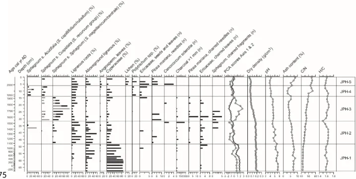
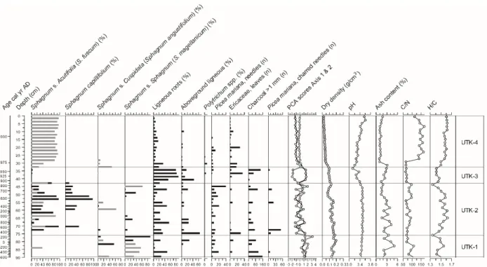
Plant communities are characterized between AD 260 and AD 890 by an alternating dominance of Sphagnum section Acutifolia, Cuspidata and Sphagnum and many Picea needles, while some levels within this section show high abundance of charcoal >1 mm and charred Picea needles suggesting one or several fires (zone McK-1; Figure 2; Table 1). An important local fire (charcoal peak) coincides with a minimal H/C value of 1.13. Ligneous taxa disappeared briefly when Sphagnum section Sphagnum became dominant between AD 890 and 1180 (zone McK-2). A shift towards drier conditions from ~AD 1180 is suggested by high presence of Cenococcum sclerotia (ectomycorrhizal fungus), increased abundance of wood fragments, a gradual decrease in C/N values and many charcoal layers indicating the occurrence of multiple local fires between AD 1180 and AD 1550 (zone McK-3 and McK-4). Ash content increased during these periods with probable local burning. A noticeable shift in vegetation assemblages is recorded around AD 1790 with the establishment of Sphagnum section Acutifolia (S. fuscum) and a pH decreasing towards 4 (zone McK-5). Particularly dry surface conditions, with the presence of the moss
Polytrichum spp., which is typical of dry ombrotrophic conditions, a temporary disappearance of
322 323 324 325 326 327 328 329 330 331 332 333 334 335 336 337 338 339 340 341 342 343 344
Sphagnum and a peak in pH (4.7) and ash content (6.1 %), are recorded around AD 1940 and
could be ascribed to local fire events (zone McK-6). The last ~50 years are characterized by the establishment of a S. fuscum cover with ligneous taxa, low pH of 3.5-4.0 and high C/N values (zone McK-7).
Figure 2. Plant macrofossil diagram and physical and chemical proxies for McK. For Sphagna, the bars indicate the total for each section (black) and the main species identified (grey). PCA sample scores of axis 1 (black line) and axis 2 (grey line) show the main shifts in vegetation.
Table 1. Details of macrofossil diagrams zonation
Site Zon
e Depth (cm) Age (year AD/BC) Main indicative plant macrofossils
McK 7 0-27.5 2014-1970 S. fuscum, wood
6 27.5-33.1 1970-1940 Polytrichum, wood
5 33.1-42.4 1940-1790 S. sect. Acutifolia
4 42.4-47.1 1790-1550 S. sect. Cuspidata and sect. Sphagnum, Picea mariana
3 47.1-54.3 1550-1180 S. sect. Acutifolia, wood, charcoal
2 54.3-68.6 1180-890 S. sect Sphagnum and sect. Cuspidata
1 68.6-92.9 890-260 S. sect Acutifolia, Picea mariana
JPH4 5 0-6.2 2013-1990 Ericaceae, Lichens, Polytrichum
4 6.2-13.8 1990-1930 S. sect. Acutifolia and sect. Cuspidata, Ericaceae, Polytrichum
3 13.8-31.7 1930-1530 S. sect. Sphagnum and sect. Cuspidata, Picea mariana
2 31.7-48.1 1530-1080 Wood, Charcoal, Ericaceae 1 48.1-67.7
1080-(300BC)
Cyperaceae spp., wood
MIL 3 0-27.2 2013-1960 S. fuscum, Ericaceae, Picea mariana 345 346 347 348 349 350 351 352 353 354 355
2 27.2-49.6 1960-1320 Picea mariana, Ericaceae
1 49.6-67.0 1320-580 Picea mariana, Cyperaceae, Ericaceae
McM 4 0-23.0 2014-1960 S. sect. Acutifolia, Polytrichum, Ericaceae
3 23.0-36.5 1960-1860 S. sect. Cuspidata and sect. Sphagnum
2 36.5-45.9 1860-1210 Ligneous fragments, charcoal
1 45.9-94.3 1210-100 S. sect. Cuspidata and sect. Sphagnum, Cyperaceae, Picea, Chamaedaphne calyculata
ANZ 4 0-25.6 2014-1980 S. fuscum, Chamaedaphne calyculata
3 25.6-34.4 1980-1960 S. riparium, Warnstorfia, Cyperaceae, Chamaedaphne calyculata
2 34.4-41.8 1960-1670 Picea mariana, Ligneous roots, Ericaceae
1 41.8-97.9 1670-630 S. angustifolium, S. magellanicum, Picea mariana
UTK 4 0-32.5 2015-1970 S. fuscum
3 32.5-42.8 1970-1850 Wood, Ericaceae, Polytrichum 2 42.8-75.8 1850-270 S. sect. Acutifolia, Picea mariana
1 75.8-92.5 270-(680BC) S. sect. Sphagnum and sect. Cuspidata, Picea mariana, charcoal
SEB 4 0-18.2 2014-1950 S. sect. Acutifolia and sect. Sphagnum, Polytrichum, Picea mariana
3 18.2-30.4 1950-1750 S. sect. Sphagnum, wood
2 30.4-87.5 1750-1110 S. sect. Sphagnum and sect. Cuspidata, Picea mariana, Cyperaceae
1 87.5-99.4 1110-1000 S. sect Cuspidata, Ligneous roots, Cyperaceae
JPH4 peatland
At JPH4 peat accumulated under wet minerotrophic conditions prior to AD 1080 (zone JPH-1) as suggested by the dominance of Cyperaceae remains, the absence of Sphagnum spp. and a pH of 5 to 6 (Figure 3; Table 1). Dry bulk density is high (0.15 to 0.20 g cm-3) in zones JPH-1 and JPH-2 and C/N is very low (20 to 40). The shift to ombrotrophy is dated at ~AD 1530 (32 cm depth) as suggested by the establishment of Sphagnum and ericaceous shrubs while pH decreased to below 5 (zones JPH 3 to 5). Sphagnum section Sphagnum became progressively dominant from ~AD 1530 along with Sphagnum section Cuspidata and Picea needles in the assemblage. Charred fragments of Sphagnum, which suggest one or several local fire events, preceded this period (zone JPH-3). The top 14 cm of the core represents drier ombrotrophic conditions from AD 1930 onwards when Sphagnum section Acutifolia established locally with the moss Polytrichum spp. and ericaceous shrubs (zone JPH-4). Finally, particularly dry conditions prevailed since AD 1990 as suggested by the development of ligneous vegetation including Picea and Ericaceae as well as 356 357 358 359 360 361 362 363 364 365 366 367 368 369 370
the top of the core, ash content is high at around 8.5%, yet pH remains low at around 4 while C/N ratios are maximal for the entire profile (> 60).
Figure 3. Plant macrofossil diagram and physical and chemical proxies for JPH4. For Sphagna, the bars indicate the total for each section (black) and the main species identified (grey). PCA sample scores of axis 1 (black line) and axis 2 (grey line) show the main shifts in vegetation.
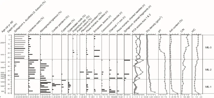
MIL peatland
MIL shows a distinct stratigraphy with a basal section characterized by a highly decomposed ligneous and Cyperaceae peat with high bulk density (> 0.16 g cm-3), high pH (~7) and high ash content (>12%), suggesting the prevalence of minerotrophic conditions prior to AD 1320 (zone MIL-1; Figure 4; Table 1). However, the presence of Cenococcum sclerotia and Picea needles in this zone suggests the existence of forested conditions. Sphagnum section Acutifolia established intermittently after AD 1320, as well as Picea and Ericaceae (zone MIL-2). This zone is characterized by multiple local fire events, as evidenced by the presence of charred plant remains such as Sphagnum and Picea needles which indicates the existence of a forested peatland. 372 373 374 375 376 377 378 379 380 381 382 383 384 385 386 387 388
Sphagnum section Acutifolia (S. fuscum) became dominant after AD 1960, with a sparse
presence of Picea, Ericaceae, Polytrichum and Pohlia nutans in the assemblage (zone MIL-3). This shift in dominant vegetation suggests a paludification process following a fire and the opening of the tree canopy. The establishment of a Sphagnum cover may be in part responsible for the local acidification after AD 1980, as shown by a pH of ~4.0. C/N and H/C values increase during this period suggesting low degree of peat decay.
Figure 4. Plant macrofossil diagram and physical and chemical proxies for MIL. For Sphagna, the bars indicate the total for each section (black) and the main species identified (grey). PCA sample scores of axis 1 (black line) and axis 2 (grey line) show the main shifts in vegetation.
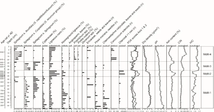
McM peatland
Zone McM-1 (AD 100-1210) shows an important presence of Picea needles, Cyperaceae and
Sphagnum section Cuspidata and sect. Sphagnum (Figure 5; Table 1). Dry density is generally
high around 0.14-0.17 g cm-3, which may be due to higher decay or the high abundance of wood, yet ombrotrophic conditions prevailed as pH was limited at 4.0 to 4.6. Between AD 1210 and 389 390 391 392 393 394 395 396 397 398 399 400 401 402 403 404 405
Dicranum and Polytrichum fragments, charcoal layers, elevated high ash contents, and low H/C
values dominates (zone McM-2). Such a botanical composition and change in physical and chemical properties suggest local permafrost development. The very low peat accumulation rate in zone McM-2 (0.013 cm yr-1) may also indicate a hiatus in the peat profile caused by fire, permafrost aggradation or both. There are two noticeable charcoal peaks between AD 1760 and 1850 indicating local-scale fire events on the peatland. This zone is overlain by an assemblage dominated by Sphagnum section Cuspidata (recurvum group), suggesting a return to relatively wet conditions and lower decay rates as shown by higher C/N values after AD 1930. Sphagnum section Cuspidata and sect. Sphagnum re-establish around AD 1930 when dry density decreases significantly and C/N and H/C values increase, indicating well-preserved peat likely corresponding to the acrotelm (zone McM-3). Finally, the top section (since AD 1970) is characterized by the establishment of Sphagnum section Acutifolia along dry conditions, as suggested by the presence of Cenococcum sclerotia, Polytrichum and abundant ligneous fragments (zone McM-4). 407 408 409 410 411 412 413 414 415 416 417 418 419 420 421
Figure 5. Plant macrofossil diagram and physical and chemical proxies for McM. For Sphagna, the bars indicate the total for each section (black) and the main species identified (grey). PCA sample scores of axis 1 (black line) and axis 2 (grey line) show the main shifts in vegetation.
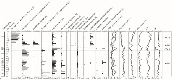
ANZ peatland
Relatively stable ecological conditions are recorded between AD 630 and AD 1670, characterized by a dominance of S. angustifolium and S. magellanicum (zone ANZ-1; Figure 6; Table 1) and a persistent local presence of Picea mariana needles. Dry density is relatively high (~0.10 g m-3) while pH remains below 4.0, indicating local ombrotrophic conditions. A major change in plant communities is recorded between AD 1670 and AD 1960 (zone ANZ-2) with the replacement of Sphagnum by ericaceous shrubs, Picea and ligneous roots. The high bulk density and low C/N and H/C values suggest enhanced peat decay due to local permafrost development or the influence of fire as suggested by a peak in macroscopic charcoal and charred Picea needles. This was followed by the establishment of hydrophilous and slightly minerotrophic 422 423 424 425 426 427 428 429 430 431 432 433 434 435 436 437
Warnstorfia with a rapid rise in H/C ratios (zone ANZ-3) which corresponds to permafrost
thawing and the formation of an internal lawn. Picea mariana disappeared around AD 1960 and have not yet re-established at the coring site. A shift towards particularly dry ombrotrophic conditions and well-preserved peat is recorded after AD 1980 as suggested by the presence of S.
fuscum and low-density peat with high C/N values, which increase throughout zone ANZ-4. Ash
content and pH increase at the top of the core.
Figure 6. Plant macrofossil diagram and physical and chemical proxies for ANZ. For Sphagna, the bars indicate the total for each section (black) and the main species identified (grey). PCA sample scores of axis 1 (black line) and axis 2 (grey line) show the main shifts in vegetation.
UTK peatland
The lower part of core UTK shows ombrotrophic conditions with dominance of Sphagnum sections Sphagnum and Cuspidata and Picea needles throughout zone UTK-1, between 680 BC and AD 270 (Figure 7; Table 1) and a pH of around 3.5. Sphagnum section Acutifolia becomes more dominant in zone UTK-2, but Picea remains present locally. Local fires have been recurrent prior to AD 1850 (zone UTK-1 and UTK-2). The most substantial shift in this core is characterized by a disappearance of Sphagnum, low C/N and H/C values suggesting increased 439 440 441 442 443 444 445 446 447 448 449 450 451 452 453 454 455 456
decay with a local dominance of Ericaceae leaves and ligneous roots around AD 1850-1970 (zone UTK-3), suggesting permafrost development. This shift is followed by a brief period of local presence of Sphagnum angustifolium around AD 1970 which may be related to permafrost thaw. This was followed by the establishment of a stable cover of Sphagnum section Acutifolia, low bulk densities and ash contents and high C/N values (poorly decayed peat), while the forest cover opened up as the local presence of Picea and Ericaceae shrubs diminishes in the macrofossil assemblages (zone UTK-4).
Figure 7. Plant macrofossil diagram and physical and chemical proxies for UTK. For Sphagna, the bars indicate the total for each section (black) and the main species identified (grey). PCA sample scores of axis 1 (black line) and axis 2 (grey line) show the main shifts in vegetation.
SEB peatland
Sphagnum sect. Cuspidata (S. angustifolium/fallax) dominates the base of the record (AD
1000-1110) with a presence of Cyperaceae and ligneous fragments while bulk density is low at around 457 458 459 460 461 462 463 464 465 466 467 468 469 470 471 472
0.05-0.10 g cm-3 (zone SEB-1; Figure 8; Table 1). Sphagnum sect. Sphagnum and Picea needle are abundant throughout zone SEB-2 (AD 1110-1750) suggesting the presence of conifers at the site while a pH around 4.0-4.5 suggests ombrotrophic conditions. The ecological conditions remained stable until around AD 1750 when Sphagnum sect Cuspidata (cf. S.
angustifolium/fallax) declined and Sphagnum magellanicum became dominant around AD
1750-1950 (zone SEB-3). Picea trees may have disappeared or became sparser as suggested by the absence of needles in this zone and ash content also increased notably after around AD 1750. The top layer (since AD 1950) is characterised by the installation of a cover of Sphagnum section
Acutifolia at the site while Sphagnum magellanicum declined locally (zone SEB-4). The
presence of Polytrichum and Picea fragments suggests a drying trend in this zone. Acidic conditions developed after AD 1990 (pH ~3.5) and C/N ratios are maximal which is characteristic of a poorly decayed peat within the oxic acrotelm layers, although ash contents remained high. 473 474 475 476 477 478 479 480 481 482 483 484 485 486
Figure 8. Plant macrofossil diagram and physical and chemical proxies for SEB. For Sphagna, the bars indicate the total for each section (black) and the main species identified (grey). PCA sample scores of axis 1 (black line) and axis 2 (grey line) show the main shifts in vegetation.
4. Discussion
The plant macrofossil records show substantial variations along and among cores over the last ~2 millennia which reflect the differences in the response of peatland vegetation to changing climate conditions and particular site- and region-specific environmental or climatic conditions. However, there are replicated vegetation changes among the cores which suggest a common response of these peatlands to climate change, especially during the LIA period and the transition towards the warmer present-day climatic conditions in central and northern Alberta. Some gradual changes in vegetation communities may have been in part driven by internal peatland processes and feedbacks. For example, the peatland surface may become drier over time due to vertical peat accumulation that gradually disconnects the vegetation from the nutrient-enriched groundwater (Damman, 1986; Belyea, 2009). Our results also suggest that fires have influenced the dynamics of these bogs with much evidence of local fire events that affected both the local vegetation communities and the physical and chemical properties of the peat.
4.1. Detection of past permafrost development in the bogs
Detecting past permafrost development within peatlands is difficult due to a lack of distinct specific plant assemblages (Oksanen, 2006; Sannel and Kuhry, 2008; Camill et al., 2009; Treat et 487 488 489 490 491 492 493 494 495 496 497 498 499 500 501 502 503 504 505 506 507 508 509 510
various physical and chemical peat properties. Three of the seven cores analysed (ANZ, UTK and McM) show signs of a permafrost aggradation phase during the LIA. At ANZ, the detected permafrost event is associated with low C/N ratios, elevated bulk density and increased ash content, suggesting increased extent of peat decay. At UTK, the permafrost phase is characterized by lower pH and elevated ash contents whereas at McM there is no clear change in C/N values but greater ash concentrations. Higher decomposition of upper peat layers may have occurred under drier surface conditions when permafrost was present locally (Zoltai, 1993) or shortly after permafrost thaw as local conditions became wetter and warmer (Jones et al., 2017; Hodgkins et al., 2014). However, permafrost aggradation is not consistently associated with increased peat humification. For example, Treat et al. (2016) showed higher C/N ratios in permafrost peat than in non-permafrost peat which could reflect a limited decomposition under cold conditions.
The C/N ratios may be affected by changes in vegetation composition such as the increase in the abundance of wood remains as recorded in these three cores but also by local fires as suggested by the study of Zaccone et al. (2014). Therefore, H/C ratios, which are less sensitive to changes in peat composition, may be a more reliable indicator of permafrost development. In our study, each layer interpreted as permafrost was characterized by a significant decrease in H/C ratio. However, these permafrost zones also coincided with evidence of one or several local fire events (i.e. abundant charcoal), which may have affected H/C values as well. In order to establish H/C values as an indicator of permafrost, possible confounding effects of fire occurrence should be verified in further studies. For example, variations in both C/N and H/C ratios have been reported by Zaccone et al. (2014) following smouldering fires of different intensity in lab 512 513 514 515 516 517 518 519 520 521 522 523 524 525 526 527 528 529 530 531 532 533 534
conditions. Charcoal concentrations can be used along with biomarkers such as retene concentration to detect past fire events in peat cores (Zhang et al., 2016). The bogs in dry continental regions of central Canada are susceptible to recurrent fires that may affect surface vegetation in consuming the upper peat layers (Turetsky and Wieder, 2001) with fire intervals estimated between 200 and 1100 years (Kuhry, 1994; Zoltai et al., 1998). The impact of fires on permafrost, peat properties, carbon sequestration and vegetation dynamics deserves to be further investigated, considering the importance of peatlands ecosystems in this region.
4.2. Impact of the LIA on peatland vegetation dynamics
Most peat cores show relatively stable vegetation dynamics prior to the LIA period (Figures 2-8). Few changes in plant assemblages seem related to the climate warming of the MCA (~AD 1100-1200) recorded by other proxy records in the region (e.g. Edwards et al., 2008; Sauchyn et al., 2015). At JPH4, the fen-bog transition around AD 1000 could be in part related to the MCA. At McK, a sharp transition from Sphagnum fallax, which is indicative of wet conditions, towards a dominance of Sphagnum fuscum which indicates dry bog conditions is recorded around AD 1100.
The most substantial changes in the vegetation communities were recorded during the last 500 years. For example, in the ANZ, McM and UTK cores there is evidence of permafrost aggradation during the LIA: the disappearance of Sphagnum, the increased abundance of ericaceous shrubs and Picea mariana trees apparently resulted from a drying of the peat surface due to frost heaving. In ANZ and UTK, there is a marked shift from woody peat to wet lawn 535 536 537 538 539 540 541 542 543 544 545 546 547 548 549 550 551 552 553 554 555 556 557
communities dominated by S. riparium and/or S. angustifolium which are typically found in peatlands following permafrost thaw in west-central Canada (Zoltai, 1993; Vitt et al., 1994; Beilman, 2001; Turetsky et al., 2007). In the McM core, there is a similar shift in vegetation composition with a disappearance of Sphagna at the expanse of ligneous roots which seems related to permafrost, but this is not followed by a clear transition towards wetter conditions. Also, based on the chronology, permafrost aggradation at this site would have occurred around AD 1400, which seems too early to be attributed to the LIA cooling documented by proxy climate records in the region mainly between AD 1550 and 1850. At McM, the formation of permafrost is more difficult to establish due to a very low peat accumulation rates between AD 1400 (44.7 cm) and AD 1850 (37.7 cm). These peat layers comprise high amounts of charcoal fragments, suggesting that a local fire created a hiatus in the peat sequence, which complicates the interpretation of the LIA period at this site.
The elevation of the peat surface and the degree of wetness after permafrost thaw in peatlands mostly depends on the original thickness of the ice lens before melting (Vitt et al., 1994). Our data suggest that the vegetation changes in ANZ, UTK and McM cores during the LIA were related to the persistence of ice lenses within the peat horizons for many decades which resulted in a slight uplifting and drying of the peat surface. Hence, this was followed by a relatively low degree of collapse after thaw associated with the development of slightly wetter conditions locally. This contrasts with other peatland sites studied in the discontinuous permafrost zone in western Canada, Alaska and Sweden where the strong subsidence of permafrost plateaus and palsas has created very wet collapse scars dominated by sedges (e.g. Prater et al. 2007; Myers-Smith et al., 2008; Hodgkins et al., 2014; McCalley et al., 2014).
558 559 560 561 562 563 564 565 566 567 568 569 570 571 572 573 574 575 576 577 578 579 580
The set of peat records is primarily characterized by a large variability in plant assemblages and peat physical and chemical properties, despite some similar patterns in direction and timing of changes during the LIA. Given the mutual proximity of the peatlands of the Fort McMurray region (McK, JPH4, MIL, McM, ANZ; Figure 1), we assume that these peatlands were subjected to highly similar trends in climate conditions in the past. The contrasted response in terms of timing and patterns of changes in these peatlands during the LIA cooling may thus be partly explained by the influence of local, internal factors such as varying microform sensitivity and stochastic processes such as fire. Although permafrost is a climatic phenomenon, the local biophysical conditions and disturbances are often predominant factors controlling its formation and degradation in the peatlands of the discontinuous and sporadic permafrost zones (Camill and Clark, 1998; Smith and Riseborough, 2002; Shur and Jorgenson, 2007; Seppälä, 2011).
Permafrost aggradation during the LIA was a localized phenomenon in the bogs of the Fort McMurray region, which was likely primarily influenced by local factors such as tree density, snow cover thickness and duration, microtopography, the presence of Sphagnum and fire (Zoltai, 1993; Camill and Clark, 1998; Camill, 2000; Bauer and Vitt, 2011). The presence of dry
Sphagnum-dominated conditions prior to the LIA has probably made these ecosystems more
susceptible to permafrost development due to the high thermal insulation of dry Sphagnum peat (Zoltai and Tarnocai, 1975; Zoltai, 1993; Robinson and Moore, 2000; Camill, 2005). Permafrost development in ANZ, McM and UTK could have been favoured by the presence of both
Sphagnum and Picea mariana as they may intercept snow, reducing the thickness of the
insulating snow cover, thus creating optimal conditions for frost penetration (Zoltai, 1993; Shur 581 582 583 584 585 586 587 588 589 590 591 592 593 594 595 596 597 598 599 600 601 602 603
and Jorgenson, 2007). However, in contrast, the removal of trees by fire may also promote permafrost development by increasing wind exposure, which reduces the snow cover and allows deeper frost penetration during winter.
At McM and UTK, the presence of abundant charcoal within the highly decayed sylvic peat suggests that fire played a role in the degradation of the local permafrost by removing a part of the vegetation cover (both Picea mariana and Sphagnum), therefore exposing the peat surface to thawing (Zoltai, 1993; Camill, 1999b). At ANZ, the shift to slightly minerotrophic and wet conditions (Sphagnum riparium) and a decline in Picea mariana ~AD 1970 most likely represents the formation of an internal lawn due to permafrost thaw (Halsey et al., 1995b). This usually leads to a rapid mortality of Picea mariana trees and a shift in bryophyte communities towards a dominance of aquatic Sphagnum (Beilman et al., 2001; Camill et al., 2001). The macrofossil data from ANZ and UTK show that the internal lawn has undergone a rapid succession towards dry ombrotrophic conditions associated with rapid peat accumulation. This is consistent with Camill (1999b) who documented successions from aquatic to dry hummock
Sphagnum communities within 50-80 years in northern Manitoba. Beilman (2001) showed the
establishment of S. fuscum in many sites following the post-LIA thaw associated to rapid vertical peat accumulation in the bogs of northern Manitoba. The transitional sequence from S. riparium to S. angustifolium and finally S. fuscum recorded at ANZ has also been documented following permafrost thaw in many northern Canadian peatlands (Zoltai, 1993; Robinson and Moore, 2000; Bauer and Vitt, 2011) and corresponds to a hydrological gradient from near-surface water tables to dry and ombrotrophic conditions (Gignac et al., 1991).
604 605 606 607 608 609 610 611 612 613 614 615 616 617 618 619 620 621 622 623 624 625 626
There is no clear evidence of permafrost aggradation and degradation specifically associated with the LIA cooling in JPH4, McK, MIL, and SEB. However, the shift from Sphagnum section
Cuspidata/Sphagnum to a dominance of S. section Acutifolia around AD 1800 in McK and the
transition to a Sphagnum-dominated bog in JPH4 around AD 1550 may well have been driven by periods of droughts during the LIA. MIL has not registered clear LIA conditions, probably because this site did not have an actively accumulating Sphagnum peat during this period and was thus insensitive to permafrost development. Finally, the absence of past permafrost development in Seba beach bog was expected considering its location outside the region of present-day and documented past permafrost peatlands. At this site, the LIA period was characterized by a shift in the dominance of Sphagnum communities from S. sect. Cuspidata (recurvum group, i.e. S. angustifolium/S. fallax) to S. magellanicum and a disappearance of
Picea trees, increase in ash content and H/C ratios around AD 1750, reflecting a change in bog
surface ecological and hydrological conditions which may have been induced by climate change.
4.3. Post-LIA conditions
Most studied peat cores show a shift toward drier, ombrotrophic conditions during the 20th century (Figure 9). All seven peat cores show an establishment of Sphagnum section Acutifolia, mostly S. fuscum, over the second half of the 20th century which coincides with warmer and drier atmospheric conditions (Luckman and Wilson, 2005; Wolfe et al., 2005; Wang et al., 2014). The recent growth of S. fuscum in the Fort McMurray region could potentially have been favoured by increased nitrogen inputs associated with industrial activities (Vitt et al., 2003; Wieder et al., 2016). However, the shift towards drier S. fuscum communities occurred in some sites of the Fort 627 628 629 630 631 632 633 634 635 636 637 638 639 640 641 642 643 644 645 646 647 648 649
McMurray area prior to the mining of bituminous sands that started in AD 1967. Moreover, the increase in Sphagnum sect. Acutifolia is also recorded at UTK bog which is located far from urban and industrial areas and is considered almost unaffected by dust deposition from anthropogenic activities (Shotyk et al., 2016; 2017). Thus, our data strongly suggest that the 20th century change in Sphagnum communities in the bogs of central and northern Alberta was driven by climate change. This is in line with the study of Wieder et al. (2016) suggesting that S.
fuscum growth may be more affected by growing season conditions than atmospheric nutrient
deposition in the bogs of the Fort McMurray region.
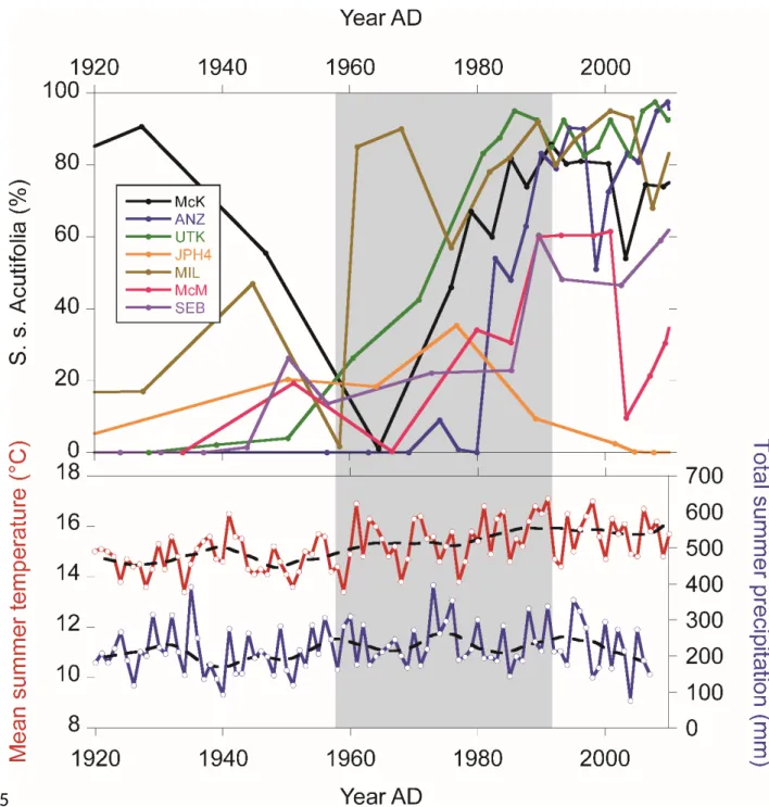
Instrumental climate records from the Fort McMurray region show temperatures increase around 1.2C since AD 1950 (Figure 9; Vincent et al., 2012). Total summer precipitation did not show a clear trend during this period but were particularly low over the last ~20 years. Given the spatially uniform shift in peatland vegetation, we conclude that the increase in summer temperature, through increased evapotranspiration and the related drying effect forced this shift towards Sphagnum section Acutifolia (S. fuscum). High-resolution records of testate amoeba assemblages from some of the sites presented here (McK, JPH4, MIL, ANZ, UTK) show a regional deepening of the water table during the second half of the 20th century in these bogs, possibly driven in part by the establishment and rapid growth of Sphagnum sect Acutifolia (van Bellen et al., accepted). The recent establishment of S. fuscum, which is a shade-intolerant species (Gignac, 1992), may also have been favored by an opening of the tree canopy and increase in light availability in some sites following the last fire that occurred between AD 1938 and AD 1951 in these bogs (Wieder et al., 2016). The recent vegetation dynamics may also have 650 651 652 653 654 655 656 657 658 659 660 661 662 663 664 665 666 667 668 669 670 671
been affected by the increased rates of atmospheric dust deposition recorded in the Athabasca Bituminous Sands (ABS) region related to industrial activities (Mullan-Boudreau, under review).
Figure 9. 20th century increase in Sphagnum section Acutifolia and temperature and precipitation records of the summer season from the Fort McMurray region (Vincent et al., 2012). Temperature and precipitation curves were smoothed with LOWESS.
672 673 674 675 676 677 678
Since the LIA, both the bogs of the Fort McMurray region and those located south of this region (UTK, SEB) have evolved towards relatively dry conditions with presence of S. fuscum cover. Projections of 21st century climate in west-central Canada show continued warming (Wang et al., 2014) and the future trajectories of these peatlands remain uncertain. Climate warming may well enhance the potential for peat accumulation (Charman et al., 2013) while future precipitation trends may tend towards an increase in summer precipitation (Price et al., 2013), although the uncertainty in precipitation projections is relatively high (Wang et al., 2014). The net effect on summer water deficit may be negative in Alberta, resulting in a decrease in water availability for peatland vegetation. If drying prevails, Sphagnum productivity is likely to decrease and ligneous vegetation may further colonize these peatlands. In addition, warmer and drier conditions and a denser ligneous cover will make these ecosystems more vulnerable to fire.
Our study highlights the importance of developing high-resolution chronologies within the upper peat layer to determine the exact timing of the LIA and subsequent warming and understand its impact on the vegetation communities. Our data are consistent with previous studies which have attributed permafrost development in central Canadian peatlands to the LIA between AD 1550 and AD 1850 (e.g. Camill, 2005). Moreover, our data suggest that the permafrost thaw in the Fort McMurray region is a recent phenomenon that occurred during the second half of the 20th century, especially under the particularly warm summer conditions of the 1960s and the 1970s (Vincent et al., 2012). Such an interpretation on the timing of permafrost development would have been impossible without the development of high-resolution chronologies based on a combination of multiple dating methods such as 14C, bomb-pulse 14C and 210Pb within upper peat layers. We have used the most highly detailed peat chronologies, for the last millennium, 680 681 682 683 684 685 686 687 688 689 690 691 692 693 694 695 696 697 698 699 700 701 702
developed so far from peat bogs of North America (Davies et al., under review). This provides a comprehensive summary of the events that occurred in these peatlands especially for the last ~500 years, a period for which the chronologies are often poorly constrained in paleoecological studies. This study also shows the importance of combining a variety of biological, physical and chemical proxies in order to improve the identification of past permafrost aggradation and degradation dynamics.
5. Conclusion
The peatlands of central and northern Alberta show a differential response to the LIA climate cooling. Three out of seven of the studied peat cores contain strong indications of past permafrost development which is most likely linked to colder LIA climate conditions. The other sites did not develop permafrost locally, even though climate conditions were favourable to this considering their latitudinal position in between some of the permafrost sites. We conclude therefore that, the spatial variability in permafrost development was probably primarily driven by local factors such as the vegetation cover in this region. However, the establishment of
Sphagnum section Acutifolia during the second half of the 20th century was widespread in these peatlands and likely resulted from recent climate warming which acted as a common external forcing factor. Our study confirms that analysing peat cores from many peatlands is essential to obtain an accurate image of the effect of climate change on peatland development at the regional scale. Moreover, we show the importance of developing high-resolution peat chronologies in order to be able to understand the LIA period which is usually poorly constrained due to the high 703 704 705 706 707 708 709 710 711 712 713 714 715 716 717 718 719 720 721 722 723 724 725
fluctuations in the 14C calibration curve over the last ~250 years. We suggest that cores from multiple peatlands may be particularly important to reconstruct environmental change especially for those located near the limit of their type distribution and/or that may be subjected to major disturbances such as fire and permafrost. The studied peatlands evolve at the current southern limit of permafrost and may thus be sensitive, even to relatively small climate change in the future.
Acknowledgments
Thanks to Alberta Innovates for funding (special thanks to John Zhou, Brett Purdy, and Dallas Johnson), to the University of Alberta, the Faculty of Agricultural, Life and Environmental Sciences, and Alberta Environment and Parks for munificent start-up support for the SWAMP laboratory, and to the Canada Foundation for Innovation for a generous equipment grant and matching funds from Alberta Enterprise and Advanced Education. Sarah Gooding, Tracy Gartner, Claudia Sabrina Soto Farfan, Melanie Bolstler, and Karen Lund provided administrative support. We thank Lucas Arantes Garcia, and Brittney Wipf for their help in the laboratory as well as Pedro Henrique Simões and Cara Albright for their help in the field. Thanks to Steve Pratte for the fruitful discussions and advices. Special thanks to Melanie Vile, Kelman Wieder, and Kevin Devito for introducing us to the beautiful bogs of this province. The manuscript has been significantly improved by the thoughtful comments from Claire Treat and two anonymous reviewers. 726 727 728 729 730 731 732 733 734 735 736 737 738 739 740 741 742 743 744 745 746 747 748 749
References
Andrejko M.J., Fiene F., Cohen A.D., 1983. Comparison of ashing techniques for determination of the inorganic content of peats. In Testing of peats and organic soils. ASTM International.
Appleby, P.G., Oldfield, F., 1978. The calculation of lead-210 dates assuming a constant rate of supply of unsupported 210Pb to the sediment. Catena 5, 1-8.
Arlen-Pouliot Y., Payette S., 2015. The influence of climate on pool inception in boreal fens. Botany 93, 637-649.
Bauer I.E., Bhatti J.S., Swanston C., et al., 2009. Organic matter accumulation and community change at the peatland-upland interface: Inferences from 14C and 210Pb dated profiles.
Ecosystems 12, 636–653.
Bauer I.E., Vitt D.H., 2011. Peatland dynamics in a complex landscape: Development of a fen-bog complex in the Sporadic Discontinuous Permafrost zone of northern Alberta, Canada. Boreas 40, 714-726.
Beilman D.W., 2001. Plant community and diversity change due to localized permafrost dynamics in bogs of western Canada. Canadian Journal of Botany 79, 983-993.
Beilman D.W., Vitt D.H., Halsey L.A. (2001) Localized permafrost peatlands in western Canada: Definition, distributions, and degradation. Arctic, Antarctic, and Alpine Research 33, 70-77.
Belyea L.R., Warner B.G., 1994. Dating of the near surface layer of a peatland in northwestern‐ Ontario, Canada. Boreas 23, 259–269.
Belyea L.R., 2009. Nonlinear dynamics of peatlands and potential feedbacks on the climate system. In: Baird AJ, Belyea LR, Comas X, et al. (eds) Carbon cycling in northern peatlands. Washington: American Geophysical Union, 5-18.
Booth R.K., 2010. Testing the climate sensitivity of peat-based paleoclimate reconstructions in mid-continental North America. Quaternary Science Reviews 29, 720-731.
Bradley R.S., Jones P.D., 1993. 'Little Ice Age' summer temperature variations: their nature and relevance to recent global warming trends. The Holocene 3, 367-376.
Bronk Ramsey C., 2008. Deposition models for chronological records. Quaternary Science Reviews 27, 42-60.
Bronk Ramsey, C., 2009. Bayesian analysis of radiocarbon dates. Radiocarbon, 51(1), 337-360. Bubier J.L., Moore T.R. and Bledzki L.A., 2007. Effects of nutrient addition on vegetation and
carbon cycling in an ombrotrophic bog. Global Change Biology 13, 1168-1186.
Camill P., 1999a. Patterns of boreal permafrost peatland vegetation across environmental gradients sensitive to climate warming. Canadian Journal of Botany 77, 721-733.
Camill P., 1999b. Peat accumulation and succession following permafrost thaw in the boreal peatlands of Manitoba, Canada. Écoscience 6, 592-602.
Camill P., 2000. How much do local factors matter for predicting transient ecosystem dynamics? Suggestions from permafrost formation in boreal peatlands. Global Change Biology 6, 169-182.
Camill P., 2005. Permafrost thaw accelerates in boreal peatlands during late-20th century climate warming. Climatic Change 68, 135-152.
Camill P., Barry A., Williams E., et al., 2009. Climate-vegetation-fire interactions and their impact on long-term carbon dynamics in a boreal peatland landscape in northern Manitoba, Canada. Journal of Geophysical Research 114, doi: 10.1029/2009JG001070 750 751 752 753 754 755 756 757 758 759 760 761 762 763 764 765 766 767 768 769 770 771 772 773 774 775 776 777 778 779 780 781 782 783 784 785 786 787 788 789 790 791 792 793 794
Camill P., Clark J.S., 1998. Climate change disequilibrium of boreal permafrost peatlands caused by local processes. The American Naturalist 151, 207-222.
Camill P., Lynch J.A., Clark J.S., et al., 2001. Changes in biomass, aboveground net primary production, and peat accumulation following permafrost thaw in the boreal peatlands of Manitoba, Canada. Ecosystems 4, 461-478.
Charman D.J., Barber K.E., Blaauw M., et al., 2009. Climate drivers for peatland palaeoclimate records. Quaternary Science Reviews 28, 1811-1819.
Charman D.J., Beilman D.W., Blaauw M., et al., 2013. Climate-related changes in peatland carbon accumulation during the last millennium. Biogeosciences 10, 929-944.
Charman D.J., Garnett M.H., 2005. Chronologies for recent peat deposits using wiggle-matched radiocarbon ages: problems with old carbon contamination. Radiocarbon 47, 135-145. Damman, A.W.H., 1978. Distribution and movement of elements in ombrotrophic peat bogs.
Oikos 3, 480-495.
Damman, A.W.H., 1986. Hydrology, development, and biogeochemistry of ombrogenous peat bogs with special reference to nutrient relocation in a western Newfoundland bog.
Canadian Journal of Botany 64, 384-394.
Davies, L.J., Froese D.G., Appleby P. (under review) High-resolution age modelling of ombrotrophic peat bog profiles from northern Alberta, Canada, using pre- and post-bomb 14C, 210Pb and historical tephra, Quaternary Geochronology
De Vleeschouwer F., Piotrowska N., Sikorski J., et al., 2009. Multiproxy evidence of 'Little Ice Age' palaeoenvironmental changes in a peat bog from northern Poland. The Holocene 19, 625-637.
Ecological Stratification Working Group, 1995. A National Ecological Framework for Canada. Agriculture and Agri-Food Canada RB, Centre for Land and Biological, Resources Research and Environment Canada, State of the Environment Directorate, Ecozone Analysis Branch. Ottawa, ON/Hull, QC. vii + 125 p.
Edwards T.W.D., Birks S.J., Luckman B.H., et al., 2008. Climatic and hydrologic variability during the past millennium in the eastern Rocky Mountains and northern Great Plains of western Canada. Quaternary Research 70, 188-197.
Environment Canada, 1982. Canadian climate normals 1951–1980. Atmospheric Environment Service, Ottawa, Ontario, Canada.
Environment Canada, 2015. Canadian Climate Normals 1981-2010 Station Data. Available at: http://climate.weather.gc.ca/climate_normals/.
Fiałkiewicz-Kozieł B., Kołaczek P., Michczyński A., et al., 2015. The construction of a reliable absolute chronology for the last two millennia in an anthropogenically disturbed peat bog: Limitations and advantages of using a radio-isotopic proxy and age-depth modelling. Quaternary Geochronology. 25, 83–95.
Garneau M., van Bellen S., Magnan G., et al., 2014. Holocene carbon dynamics of boreal and subarctic peatlands from Québec, Canada. The Holocene, 1-11.
Gignac, D., 1992. Niche structure, resource partitioning and species interactions of mire bryophytes relative to climatic and ecological gradients in western Canada. Bryologist 95, 406–418.
Gignac L.D., Vitt D.H., Zoltai S., et al., 1991. Bryophyte response surfaces along climatic, chemical, and physical gradients in peatlands of western Canada. Nova Hedwigia 53, 27-71. 795 796 797 798 799 800 801 802 803 804 805 806 807 808 809 810 811 812 813 814 815 816 817 818 819 820 821 822 823 824 825 826 827 828 829 830 831 832 833 834 835 836 837 838 839