CEST2013 – Athens, Greece Ref no: XXX
DROUGHT-RELATED VULNERABILITY AND RISK ASSESSMENT OF GROUNDWATER RESOURCES UNDER TEMPERATE CONDITIONS
B. VERBEIREN1, M. HUYSMANS1, B. TYCHON2, I. JACQUEMIN2, F. CANTERS3, S. VANDERHAEGEN3, G. ENGELEN4, L. POELMANS4, P. DE BECKER5, G. TSAKIRIS6,
H. VANGELIS6 AND O. BATELAAN1 O.
1
Department of Hydrology and Hydraulic Engineering, Vrije Universiteit Brussel (VUB), Pleinlaan 2, 1050 Brussels, Belgium. 2 Groupe Agrométéorologie, Département des sciences et gestion de l’environnement, Université de Liège (Ulg), Avenue de Longwy 185, 6700 Arlon, Belgium. 3 Department of Geography, Vrije Universiteit Brussel (VUB),
Pleinlaan 2, 1050 Brussels, Belgium. 4 Unit Ruimtelijke Milieuaspecten, Vlaamse Instelling voor Technologisch Onderzoek (VITO), Boeretang 200, 2400 Mol, Belgium.
5 Instituut voor Natuur- en Bosonderzoek (INBO),
Kliniekstraat 25, 1070 Brussels, Belgium.
6 Centre for the Assessment of Natural Hazards and Proactive Planning, National
Technical University of Athens, Heroon Polytechniou 9, 15780 Zografou, Greece. Email: Boud.Verbeiren@vub.ac.be
EXTENDED ABSTRACT
Drought hazards are usually associated with (semi-)arid regions. Due to the assumed insignificance of drought hazards under temperate conditions this field remains poorly studied. This study aims at filling this gap by: (1) Increasing understanding of influencing factors determining drought in a temperate context; (2) Developing a methodology and quantitative tools aimed at planning and decision support with respect to groundwater management. In the first place drought is a phenomenon caused by deficient precipitation for a large area and significant duration and as such it is mainly a meteorological-related hazard. In case the temporary water deficiency affects groundwater bodies, the term groundwater drought is used. Groundwater droughts develop slowly but can have considerable socio-economic and environmental consequences. Groundwater drought is a complex phenomenon. Three main variables are important: groundwater recharge, groundwater level and groundwater discharge. Groundwater recharge is important as it is the source (inflow) of all groundwater. The groundwater table gives an indication of the storage, while groundwater discharge represents the outflow from the groundwater system. Next to natural meteorological variations also human induced factors play a role. In the Belgian context the main influencing factors determining the inflow and potentially resulting in a recharge deficit and an overall deterioration of groundwater resources are climate and land use/land cover. Groundwater demand for human activities has a direct effect on groundwater storage (level). The combined effect of these factors makes that some groundwater bodies are under pressure. In these groundwater bodies the outflow exceeds the inflow generating a reduction in storage and hence an unsustainable situation. A thorough knowledge of all three influencing factors and their interaction or combined effect is essential for a reliable estimate of the groundwater budget and a sustainable management. Hence, there is a need for an improved understanding of groundwater drought and the human-induced factors influencing the groundwater balance. This should form the basis for an integrated approach which allows tackling these negative effects and safeguarding sustainability of groundwater resources.
Keywords: groundwater drought, temperate conditions, influencing factors, impacts, vulnerability, risk.
1. INTRODUCTION
Drought can be described as a temporary decrease in water availability over a significant period of time, deviating from normal conditions. In contrast to e.g. flooding, which has a direct and visible effect, drought is a creeping natural hazard (Wilhite, 1993). In the first place drought is a direct result of deficient precipitation and as such it is mainly a meteorological-related hazard. Typically three definitions of drought are used: meteorological, agricultural and hydrological drought. The first is referring to a period without or with little precipitation; the second is referring to a shortage of water in the soil and as such for crops or natural vegetation; the third is describing an impact on hydrological bodies. In case it concerns groundwater bodies the term groundwater drought is used. Groundwater droughts develop slowly but can have considerable socio-economic and environmental effects (Vogt & Somma, 2000). Groundwater drought is a complex phenomenon and is hard to identify (Van Lanen & Peters, 2002). To describe groundwater drought three main variables are important: groundwater recharge, groundwater level and groundwater discharge (Tate & Gustard, 2000; Van Lanen & Peters, 2002). Groundwater recharge is important as it is the source (inflow) of all groundwater. The groundwater table gives an idea of the storage, while groundwater discharge represents the outflow from the groundwater system.
Notwithstanding the importance of groundwater as a valuable source of freshwater the concept of groundwater drought remained relatively unstudied. Only since the late nineties there has been a growing interest for this slow and creeping natural hazard. Calow et al. (1999) give a conceptual definition of groundwater drought, describing it as ‘a situation where groundwater sources fail as a direct consequence of drought’. This rather narrow definition is closely linked to the specific application in an African arid context. Van Lanen & Peters (2000) use a more general definition where groundwater drought occurs when the groundwater heads in an aquifer drop below a certain level. A further extension of the definition considers groundwater drought as ‘a special type of hydrological drought that occurs when groundwater recharge R, level H or discharge Q deviate from ‘normal’ (Peters et al., 2005; Tallaksen & Van Lanen, 2004). Van Lanen & Peters (2002) also introduce a differentiation between natural and induced groundwater drought; the latter referring to the groundwater level drop as a result of human activities (e.g. extraction, drainage, etc.)
Typical approaches to assess groundwater drought focus on timeseries of the three variables R, H and Q mentioned above. The most common methods when working with groundwater level is a threshold level approach or the Sequent Peak Algorithm (Tallaksen & Van Lanen, 2004). For the first method the cumulative deficit method is preferred over a fixed threshold (Shahid & Hazarika, 2006). To obtain a groundwater recharge timeseries a water balance model is often used, sometimes in combination with a groundwater flow model. The spatial (500m-5km) and temporal (1d-1m) resolution in different studies vary a lot, but are mostly on the coarse side. Mendicino et al. (2008) developed a Groundwater Resource Index (GRI) in a Mediterranean climate starting from a water balance model.
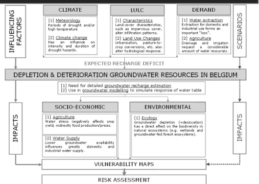
Although commonly used definitions of (groundwater) drought only consider natural meteorological variations, also human induced factors play a role with respect to the depletion and deterioration of groundwater resources. In the Belgian context the main influencing factors, determining the inflow and storage, potentially resulting in a recharge deficit and an overall deterioration of groundwater resources are: climate, land use/land cover (LULC) and groundwater demand for human activities. The combined effect of these factors makes that some groundwater bodies are under pressure. In these groundwater bodies the outflow exceeds the inflow generating a decline in groundwater
storage, thus causing an unsustainable situation. Figure 1 summarizes the problem of depletion and deterioration of groundwater in the Belgian context and the related socio-economic and environmental impacts.
A thorough knowledge of all three influencing factors and their interaction or combined effect is essential for a reliable estimate of the groundwater budget and a sustainable management. Especially because expected changes in climate (Houghton et al. 2001), land use and demand are likely to reinforce these negative effects, having substantial socio-economic and environmental impacts. Therefore there is a need for an improved knowledge on climate-related and human-induced effects of groundwater drought. This should form the basis for an integrated approach which would allow tackling these negative effects and safeguarding sustainability. Moreover such an approach is essential in meeting the objectives of the EU Water Framework Directive (WFD), which requires from the member states to monitor groundwater resources. The outcomes will serve the concerned authorities in setting priorities for an integrated sustainable management and reduced risk for groundwater resources in Belgium.
This paper intends to present the objectives and methodology of the GroWaDRISK project, aiming at the development of a drought-related vulnerability and risk assessment strategy for the sustainable management of groundwater resources under temperate conditions.
Figure 1. Problem statement – Factors and context regarding depletion of groundwater resources in Belgium.
2. OBJECTIVES
Drought hazards are usually associated with (semi-)arid regions. Due to the assumed insignificance of drought hazards under temperate conditions this field remains poorly studied.
1. Increasing policy-relevant understanding of influencing factors (climate-LULC-demand) determining groundwater drought in a temperate context.
2. Obtaining reliable spatially distributed timeseries for groundwater recharge and water table levels, enabling to describe where (space) and when (time) groundwater drought occurred/occurs.
3. Assessing the socio-economic and environmental impacts of groundwater drought at a large catchment scale for the present and future situation (coming 30 years).
4. Mapping the individual and combined vulnerability of groundwater resources.
5. Assessing the risk as a monetary loss in order to enable objective evaluation and reduce the groundwater drought risk towards the future.
6. Developing a methodology and supporting quantitative tools aimed at planning and decision support with respect to groundwater management, applicable at the level of river basins in Belgium and beyond.
7. Informing the public, consisting of domain specialists and lay persons, about the results of the analysis carried out in the case region, by means of an Internet-based indicator atlas.
3. METHODOLOGY
3.1. Groundwater drought assessment strategy
In order to assess drought-related vulnerability and risk of groundwater resources an integrated water balance and groundwater modelling strategy is applied in combination with a threshold method.
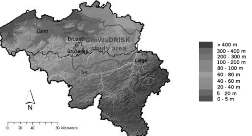
The study area is the Dijle and Demer catchment in central Belgium. These catchments correspond more or less with the boundaries of the underlying vulnerable Brulandkrijt groundwater system (Figure 2). The elevation ranges between 10 and 100m. Belgium has a maritime temperate climate with a long-term average annual rainfall around 800 mm and an average temperature around 10 °C.
Figure 2. The study area is the Brulandt-Krijt groundwater system in Belgium (Background: relief of Belgium – NGI).
The first step is a groundwater drought hazard assessment to increase knowledge and understanding of groundwater drought in a Belgian context. Starting point is a thorough analysis of the main influencing factors. Regarding the climate factor, a hydro-meteorological time-series analysis combined with a drought index approach enables the identification and characterization of historical and recent meteorological drought
hazards. Land-use/land-cover characterization focuses on the estimation and mapping of agricultural land use change and change of impervious fraction cover, which are very sensitive and determining parameters for recharge estimation.
The complex interaction of influencing factors demands a multi-disciplinary modelling approach to generate a reliable estimation of spatially distributed groundwater recharge and water table timeseries using the combined water balance and groundwater modelling strategy. Next the baseline scenario, representing a sustainable groundwater system, is defined. Using the threshold method the “rules” to maintain the groundwater system sustainable are set. This baseline scenario forms the basis for the final groundwater drought risk assessment.
Based on groundwater simulations the baseline (reference) and current status of agriculture (crop yield), natural ecosystems and water supply are determined. A next step is to study the future impact of changing influencing factors on the total system. Readily available socio-economic and climate scenarios (IPCC SRES, 2000) are combined with specific demand scenarios and used in a high-resolution land-use change model to compute future LULC. Using the water balance and groundwater model the individual and overall impact can be assessed, not only on groundwater resources, but also on future agricultural production, natural ecosystem health and water supply. This impact analysis forms the basis for vulnerability mapping for each of the separate aspects.
Finally, the individual risk related to the socio-economic activities will be assessed as a monetary loss. From individual risks, using the multi-criteria approach, the composite risk will be determined.
3.2. Research topics
The scientific activities within the frame of the GroWaDRISK project can be divided into seven main research topics:
a. Rainfall analysis and drought hazards b. Impervious surface mapping
c. Land-use change scenario modelling
d. Water budget and groundwater table simulation e. Impact on agriculture
f. Impact on natural ecosystems g. Drought risk assessment
Below follows the methodological details with respect to each of these research topics with a focus on the innovative elements of the proposed approach.
a. Rainfall analysis and drought hazards
A monthly meteorological time-series analysis (1954-2011) is combined with a drought index approach to identify and characterize historical and recent meteorological drought hazards. In order to account for spatial variation, the monthly data measured in the meteorological stations is converted to 10 by 10 km gridded maps. These map data forms the input for the calculation of drought indices (RDI SPI, Palmer, scPSDI). The Reconnaissance Drought Index (RDI) is a drought index similar to the most popular one, the Standard Precipitation Index (SPI), but it is calculated based on the two major
determinants of the water balance (surface or groundwater), the precipitation and the potential evapotranspiration. In fact the basic variable is the ratio of cumulative precipitation over the cumulative potential evapotranspiration and is calculated for each selected reference period (Tsakiris, Pangalou & Vangelis, 2007). RDI has been successfully applied in a number of countries in Europe, Africa and Asia proving that it is a comprehensive and sensitive index suitable to detect droughts as well as climatic changes and trends (Vangelis et al., 2013).
While the drought indices above are mainly used to assess meteorological drought, the drought index analysis also aims at assessing agricultural drought. Particularly by the study of the Relative Soil Moisture Index obtained with the Belgian Crop Growth Monitoring System (B-CGMS) which provides 10-daily information about the soil moisture conditions related to crops and their requirements (De Longueville et al., 2004).
b. Impervious surface mapping
One of the most important factors determining surface water budgeting and groundwater recharge is the presence of artificial, impervious surfaces preventing water from infiltrating the soil. Complementing available large-scale data, medium-resolution satellite imagery (SPOT V) is used to obtain reliable estimates of impervious surface proportions. Within urbanised pixels, identified using ancillary data, a multi-resolution approach is applied to obtain sub-pixel estimates of impervious surface cover. Alternative models for estimating sub-pixel impervious surface cover, according to the multiple endmember unmixing concept (Powell et al., 2007 and 2011), are tested. Model calibration and validation is based on more detailed information on impervious surface distribution, which will be derived from high-resolution remote sensing data for one or more spatial subsets covering a variety of land-uses within the study area. Sub-pixel estimates of impervious surface cover will be used for water budget calculation for the present situation, and for modelling future impervious surface cover in connection with drought risk assessment for various land-use change scenarios.
c. Land-use change scenario modelling
While land-use change is important in itself, it is often used as a surrogate for other socio-economic data, such as presence of population or socio-economic activity. The latter are more difficult to obtain and predict at useful spatial levels of detail. In dealing with drought, it is important to know accurately where impervious surfaces prevent water from infiltrating the soil but also where particular groundwater exploitation levels can be expected. In this context, the densities of residential or economic activities determine the extent of the impervious surface, the amount of run-off, the exploitation of groundwater, etc. It is therefore most useful to know the intensity of these activities on each spatial entity or cell. To explore potential land-use changes, a multi-activity cellular automaton (ACA) framework will be applied (White et al., 2012) modelling both land use and densities of population and economic activity. It thus realistically represents the fact that a mix of activities determines the type of land-use in each location. The multi-scale processes determining the location of population, economic activity, and land-use are captured in a variable grid representation, in which the neighbourhood includes the entire modelled area. The resolution of the model is 1 ha. Natural land uses, population and economic activities are represented in a dozen aggregated categories determined function of their relevance in the study area, their sensitivity to drought and the pressure exerted on groundwater.
The model is initialised with population and employment density information at the cellular level. Novel in this project is the extension of the model with (1) remote sensing derived information on impervious surface cover, and (2) a simple agent-based mechanism
simulating farmer’s crop choices in the agricultural areas. Land-use dynamics unfold in a heterogeneous cellular space, characterised by the bio-physical suitability, the zoning status and the accessibility relative to the transportation system. In the project, the bio-physical suitability will depend on the climate scenarios and their associated drought characteristics determined within the framework of the project.
d. Water budget and groundwater table simulation
Groundwater recharge is the source of all groundwater, which at its turn forms a valuable natural source for a wide range of human activities and is essential for specific natural ecosystems. Therefore a reliable estimate of the groundwater recharge is crucial for a sustainable management of groundwater resources. Groundwater recharge is depending on a combination of physical conditions and meteorological factors. The water budget calculation is simulated using the WetSpaSS model (Batelaan & De Smedt, 2001 & 2007). The water budget calculation for agricultural soils is assessed with the Belgian Crop Growth Monitoring System (B-CGMS) and integrated into the WetSpaSS modelling approach in order to ensure consistency between the simulations.
The spatially distributed groundwater recharge timeseries forms a direct input for the groundwater table simulation using a typical groundwater modelling approach with the MODFLOW model (Harbaugh et al., 2000). It is a three-dimensional numerical model based on the finite-difference technique.
WetSpass and MODFLOW are iteratively coupled in order to enable feedback mechanisms between meteorological input and hydrological response of the groundwater body. The combined modelling approach allows simulation of the groundwater table for the baseline and current situation. In a later phase the groundwater model will be used to assess (future) impacts of climate, land-use and demand changes on groundwater resources in the area.
Based on the simulation results for the baseline scenario, threshold functions of the selected determinants of the groundwater balance are determined within the context of aquifer sustainability. Aquifer sustainability is tested using recharge-consumption timeseries in which no systematic trend is detected (Tsakiris et al., 2007a). The modelling results are combined with engineering judgment and information from other studied aquifers to define seasonal thresholds. Also the use of spatially varying (valley vs. interfluvia) thresholds is tested and conventional theories of safe yield are utilized (Tsakiris et al., 2007a).
e. Impact on agriculture
To assess the impact of drought-related changes in groundwater recharge and the groundwater table on agricultural crop growth, the Belgian Crop Growth Monitoring System B-CGMS (Vossen and Rijks, 1995, Tychon et al., 1999, Boogaard et al. 2002, Tychon et al., 2004) will be used. CGMS (and B-CGMS for Belgium) is a spatially distributed version of WOFOST (World FOod STudies), a mechanistic crop growth model (Diepen et al.,1989) that describes plant growth by using light interception and CO2
assimilation as growth driving processes and by using crop phenological development as growth controlling process. Today the CGMS is one of the major tools of the European Crop Growth Forecasting System set up for the European Commission.
The Crop Growth Monitoring System (CGMS and B-CGMS for Belgium) allows regional application of WOFOST by providing a database framework which handles model input (meteorological and soil data and crop types with their specific parameters) and model
output (crop indicators such as total biomass, grain yield and leaf area index, transpiration, relative soil moisture,…). The computed scenarios (considering climate and land-use changes and their possible consequences for future agricultural practices in Belgium) will provide the evolution of the crop water balance and of its impact on crop yield. Indeed the model can be applied in two different ways: (1) a potential mode, where crop growth is purely driven by temperature and solar radiation without any growth limiting factors (2) A water-limited mode, where crop growth is limited by the availability of water. The difference in yield between the potential and water-limited mode can be interpreted as an effect of drought.
f. Impact on natural ecosystems
The water balance is of major importance with respect to nature conservation in Western Europe. Groundwater quantity (and quality) plays a key role in conservation and development of biodiverse wetlands. During the last decade a lot of research has been carried out aimed at detecting specific and detailed quantitative site conditions for groundwater dependant vegetation types. It resulted in accurate knowledge on the ecological range of occurrence of groundwater dependent vegetation types. More specifically, much effort has been spent in gathering data with respect to groundwater regime variables such as mean lowest, mean highest and mean GW level. Along with a number of chemical variables and response to land-use, management type or flooding, all the site conditions were combined in an hydrological dataset FLAWET and an eco-hydrological model NICHE (Callebaut et al. 2009). This model allows predicting the vegetation response to changing hydrological site conditions, especially changes in groundwater regime such as the drought-related lowering of the phreatic level. The model will be applied to compare actual or historical reference situations with future scenarios.
g. Drought risk assessment
Starting from the baseline scenario, the defined threshold functions (“rules”) are used in combination with the scenario simulations in order to determine the individual risk for the related socio-economic sectors (agriculture, industry, etc.) as a monetary loss. Also a combined risk is calculated using a multi-criteria approach. A loss in ecological values is considered as a limiting factor in the risk calculation. Uncertainty of the influencing factors on the groundwater recharge and groundwater balance simulations will be taken into account in the risk assessment.
5. CONCLUSIONS
Groundwater droughts develop slowly but can have considerable socio-economic and environmental consequences. Groundwater drought is a complex phenomenon and hard to identify and assess. Although commonly used definitions of (groundwater) drought only consider natural meteorological variations, also human induced factors play a role with respect to drought-related depletion and deterioration of groundwater resources. The complex interaction of influencing factors demands a multi-disciplinary modelling approach to generate a reliable estimation of spatially distributed groundwater recharge and groundwater table timeseries and assess socio-economic and environmental impacts.
The research methodology presented in this paper aims at an increased understanding of the influencing factors and the development of a quantitative tool to address drought-related deterioration of groundwater resources.
The outcomes of the project will serve concerned authorities and those responsible for operational management in setting priorities for an integrated sustainable management and a reduced risk for groundwater resources in Belgium. Moreover such an approach is essential in meeting the requirements of the EU Water Framework Directive (WFD) towards EU member states to describe and monitor their groundwater resources.
ACKNOWLEDGEMENTS
The research presented in this paper (GRoWaDRISK project SD/RI/05a, 2012-2016) is funded by the Belgian Science Policy Office (BELSPO) within the framework of the ‘Science for Sustainable Development’ research programme.
REFERENCES
1. Batelaan, O. and De Smedt, F. (2001), WetSpass: a flexible, GIS based, distributed recharge methodology for regional groundwater modelling. In: Gehrels, H., Peters, J., Hoehn, E., Jensen, K., Leibundgut, C., Griffioen, J., Webb, B. and Zaadnoordijk, W-J. (Eds.). Impact of Human Activity on Groundwater Dynamics, IAHS Publ. No. 269: 11-17.
2. Batelaan, O. and De Smedt, F. (2007), GIS based recharge estimation by coupling surface/subsurface water balances. Journal of Hydrology, 337(3-4), 337-355, doi: 10.1016/j.jhydrol.2007.02.001.
3. Boogaard, H., Eerens, H., Supit, I., Diepen, C. v., Piccard, I. and Kempeneers, P.(2002). Description of the MARS crop yield forecasting system (MCYFS),Technical report, Joint Research Centre.
4. Callebaut, J., De Bie, E, De Becker, P. and Huybrechts, W. (2007), NICHE Vlaanderen : SVW : 1-7. Rapporten van het Instituut voor Natuur- en Bosonderzoek.
5. Calow, R., Robins, N., MacDonald, A. & Nicol, A. (1999), Planning for groundwater drought in Africa. Technical Documents in Hydrology no. 35, 255-270. UNESCO, Paris.
6. De Longueville, F., Horion, S., Tychon, B. & Ozer, P. (2004), Analyse de la campagne agricole en 2003 en terme de stress hydrique, Bulletin de la Société géographique de Liège, 44, 2004, 97-103.
7. Diepen, C.A. v., Wolf, J. and Keulen, H., v. (1989). WOFOST: a simulation model of crop production, Soil Use and Management 5: 16–24.
8. Harbaugh, A.W., Banta, E.R., Hill, M.C., McDonald, M.G. (2000), MODFLOW-2000, the US Geological Survey modular ground-water models; user guide to modularization concepts and the ground-water flow process. US Geological Survey.
9. Houghton, J.T., Ding, Y., Griggs, D.J., Noguer, M., van der Linden, P.J., Dai, X., Maskell, K. and Johnson C.A. (2001), Climate change 2001 – The scientific basis. Cambridge University Press, New York, 882 p.
10. IPCC SRES (2000), Nakiüenoviü, N., and Swart, R., ed. (book), Special Report on Emissions Scenarios: A special report of Working Group III of the Intergovernmental Panel on Climate Change, Cambridge University Press, ISBN 0-521-80081-1.
11. Mendicino, G, Senatore, A, Versace, P. (2008), A Groundwater Resource Index (GRI) for drought monitoring and forecasting in a Mediterranean climate. J Hydrol 357:282–302
12. Peters, E., Lanen, H.A.J. van, Torfs, P.J.J.F., and Bier, G. (2005), Drought in groundwater – drought distribution and performance criteria. J. Hydrol. 306, 302-317.
13. Powell, R.L., Roberts, D.A., Dennison, P.E. and Hess, LL. (2007). Sub-pixel mapping of urban land cover using multiple endmember spectral mixture analysis: Manaus, Brazil. Remote Sensing of Environment 106, 2, 253-267.
14. Powell, R.L. (2011). Characterizing urban subpixel composition using spectral mixture analysis. In Yang, X. (Ed.), Urban Remote Sensing: Monitoring, Synthesis and Modelling in the Urban Environment. John Wiley & Sons, pp.111-128.
15. Shahid, S. and Hazarika, M.K. (2010), Groundwater Droughts in the Northwestern Districts of Bangladesh, Water Resources Management, 24(10): 1989-2006
16. Tallaksen, L.M. & Lanen, H.A.J. van eds. (2004), Hydrological Drought – Processes and Estimation Methods for Streamflow and Groundwater. Developments in Water Science 48, Elsevier Science B.V., Amsterdam, the Netherlands.
17. Tate, E.L. and Gustard, A. (2000), Drought definition: a hydrological perspective, In: Drought and Drought Mitigation in Europe (ed. by J.V.Vogt and F.Somma), Advances in Natural and Technological Hazards Research, vol. 14, Kluwer Academic Publishers, the Netherlands, 23-48.
18. Tsakiris, G., Pangalou, D. and Vangelis, H. (2007) Regional Drought Assessment Based on the Reconnaissance Drought Index (RDI), Water Resources Management 21 (5) pp. 821-833 19. Tsakiris, G., Cancelliere, A., Tigkas, D., Vangelis, H., Pangalou, D., Bonaccorso, B., Moneo, M., Nicolosi, V. (2007a) Tools and Models. In: A. Iglesias, M. Moneo, A. Lopez-Francos (Eds) Drought Management Guidelines Technical Annex, CIHEAM/EC MEDAWater, Zaragoza, pp. 135-164.
20. Tychon, B., Buffet, D., Dehem, D., Oger, R., Veroustraete, F. and Wouters, K. (1999), Adaptation of the European crop growth monitoring system to the Belgian conditions, pp263-264, Proceedings of the International symposium on Modelling Cropping Systems, Lleida, 21-23 june 1999.
21. Tychon, B., De Longueville, F., Horion, S. & Ozer, P. (2004), B-CGMS for drought monitoring in Belgium. in: Natural hazards in the Saar-Lor-Lux region: Monitoring hazards, assessing risks and mitigating disasters, PFISTER L., HOFFMANN L. S. & STORONI A. (eds.), CRP Gabriel Lippmann & Université du Luxembourg: 38-39.
22. Van Lanen, H.A.J. and Peters, E. (2000), Definition, Effects and Assessment of Groundwater Droughts. In: Drought and Drought Mitigation in Europe (ed. by J. Vogt & F. Somma), Advances in Natural and Technological Hazards Research, vol. 14, Kluwer Academic Publisher, Dordrecht, the Netherlands, 49-61.
23. Van Lanen, H.A.J. and Peters, E. (2002), Temporal variability as an indicator for natural groundwater droughts in two climatically contrasting basins. In: FRIEND2002 – Regional Hydrology: Bridging the Gap between Research and Practice (ed. by H.A.J. Van Lanen & S. Demuth), IAHS Publ. no. 274, 101-108.
24. Vangelis, H., Tigkas, D. and Tsakiris, G. (2013). The effect of PET method on Reconnaissance Drought Index (RDI) calculation, Journal of Arid Environments 88 pp. 130-140.
25. Vogt, J. and Somma, F. (2000), Drought and Drought Mitigation in Europe. Advances in Natural and Technological Hazards Research, vol. 14, Kluwer Academic Publishers, The Netherlands.
26. Vossen, P., Rijks, D.A., (1995), Early crop yield assessment of the EU countries. The system implemented by the Joint Research Centre. Publication EUR 16318 EN of the Office for Official Publications of the EU, Luxembourg
27. White, R., Uljee, I., and Engelen, G. (2012), Integrated Modelling of Population, Employment, and Land Use Change with a Multiple Activity Based Variable Grid Cellular Automaton, International Journal of Geographical Information Science, 26 (7), 1251-1280.
28. Wilhite, D., (1993), The enigma of drought. In: Wilhite D. (ed.). Drought Assessment, Management and Planning: Theory and Case Studies. Boston: Kluwer Academic Publishers, 3-30.