Assembly and concept of a web-based GIS within the paleolimnological
project CONTINENT (Lake Baikal, Russia)
1Birgit Heim · 2Jens Klump ·1Hedi Oberhänsli · 3Nathalie Fagel 1
Climate Dynamics and Sediments, GeoForschungsZentrum Potsdam, 14473 Potsdam, Germany 2Data Centre, GeoForschungsZentrum Potsdam, 14473 Potsdam, Germany
3Geology Department, Clays and Paleoclimate, University of Liège, 4000 Liege, Belgium
Abstract
Web-based Geographical Information Systems (GIS) are excellent tools within interdisciplinary and multi-national geoscience projects to exchange and visualize project data. The web-based GIS presented in this paper was designed for the paleolimnological project 'High-resolution CONTI-NENTal paleoclimate record in Lake Baikal' (CONTINENT) (Lake Baikal, Siberia, Russia) to allow the interactive handling of spatial data. The GIS database combines project data (core positions, sample positions, thematic maps) with auxiliary spatial data sets that were downloaded from freely available data sources on the world wide web. The reliability of the external data was evaluated and suitable new spatial datasets were processed according to the scientific questions of the project. GIS analysis of the data was used to assist studies on sediment provenance in Lake Baikal, or to help answer questions such as whether the visualization of present-day vegetation distribution and pollen distribution supports the conclusions derived from palynological analyses. The refined geodata are returned back to the scientific community by using online data publication portals. Data were made citeable by assigning persistent identifiers (DOI) and were published through the German National Library for Science and Technology (TIB Hannover, Hannover, Germany).
Keywords: Web-based GIS; Lake Baikal; Catchment lithology; Plant distribution; Open access to data; Data
publication
Introduction
As the number and interdisciplinarity of primary scientific data has grown, problems related to accessibility, and re-evaluation have also increased considerably. The creation of digital data collections offers possibilities for data management and sharing, by this enhancing research capacities for all scientific disciplines. Geographical Information Systems (GIS) technology and the world wide web are tools to allow the visual interpretation of data with a spatial dimension. This paper illustrates the application of GIS technology, web-based data acquisition and web-based data publication within a geological and biological study at Lake Baikal in Siberia (Russia). There is considerable interest in the application of paleolimnology of Lake Baikal to reconstruct the
environmental history of Central Siberia. Climatically, the high-continental Baikal region is controlled by the Siberian Anticyclone, East Asian Monsoon Cyclones and North Atlantic Westerlis. Lake Baikal's sediments are a source of unique data, potentially recording climate changes over the past 25 Million years (Hutchinson et al. 1992), and were studied since the 1990s (Bezrukova 1999; Flower 1998; Flower et al. 1999; Karabanov et al. 2000). Sakaguchi et al. (2006), Sapota et al. (2006), Soma et al. (2007) and Swann and Mackay (2006) investigated site-specific drawbacks as they showed in the same way the high paleoclimate potential and broad field of applications for coastal and pelagic Baikal records.
The GIS visualization and spatial analysis of the present-day conditions at Lake Baikal, as described here, is tied to the European 'High-resolution CONTINENTal paleoclimate record in Lake Baikal' (CONTINENT) project, which was conducted in the years 2001-2004. Several authors from the CONTINENT project (Demske et al. 2005; Fietz et al. 2007; Granoszewski et al. 2005; Oberhänsli and Mackay 2005) describe how project results were used to reconstruct a continuous palaeoclimate record from a mid-latitude continental setting, with a centennial to decadal resolution over the last 20 kys and with a centennial time resolution for the time slice 110-130 kys B.P. A key objective was also to understand present-day processes of fluvial input (Fagel et al. 2007), eolian input and primary biomass production processes in the photic zone of Lake Baikal (Fietz and
Nicklisch 2004; Heim et al. 2005; Straskrabova et al. 2005). By evaluating the transport of potential climate proxies to the deep lake bottom (Fietz et al. 2005), transfer functions were derived for interglacial periods applicable to longer records such as the Baikal Drilling Project (BDP) cores (Williams et al. 1997).
The complex nature of the study called for innovative data management strategies. Within paleoclimate projects, strategies commonly focus on data from sediment cores and successful design patterns for management of cores (e.g. National Lacustrine Core Repository (LacCore), Schnurrenberger et al. 2001) and data models
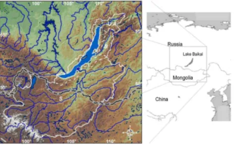
(Diepenbroek et al. 2002) have been established. In addition to handling data from diachronous analyses of sediment cores, paleolimnological research is also occupied with synchronous lake studies (Pienitz and Smol 1993) and studies of the lake catchment (O'Sullivan et al. 1991). In the context of the CONTINENT project, the studied area stretches from central Siberia in the Russian Federation towards Mongolia to the south (Fig. 1). The sampling positions from ten expeditions and associated projects are distributed over an area of ~2 million square kilometres and spread over six degrees of geographic latitude. It is evident that in a study of this scale all data have to be analysed in their spatial context and at different scales. The study also required the incorporation of auxiliary spatial data on the topography, geology and other relevant geodata.
Fig. 1 Lake Baikal,situated at the centre of the Asia continent , in southern Siberia. The square indicates the area covered by the CONTINENT Baikal-GIS data (1,620 × 1,760 km ). Its lake catchment and the catchments of its main tributary are outlined (white lines, Swiercz 2004) S-Selenga catchment, B-Barguzin catchment, U.A.-Upper Angara catchment. The dashed black line south of Lake Baikal marks the borders between Russia, Mongolia and China
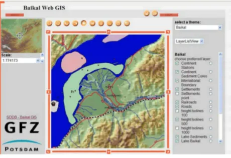
The rationale to set up a GIS as part of the scientific activities was that visualization of the spatial context of the project sites and thematic background information (e.g. morphology, pedology, geology, vegetation) can help to understand and interpret research data (Butler 2006; Lyon et al. 2006). However, conventional databases and GIS applications require sophisticated information, technology infrastructure and skilled users, and access is restricted locally to the institution operating the system. To circumvent these restrictions, the CONTINENT Baikal-GIS has been set up as a web-based GIS (doi:10.1594/GFZ.SDDB.1201). There are significant advantages to a web-based GIS in international networked projects, such as the CONTINENT project, since it allows all participating scientists to access spatial, project related information, regardless of the local availability of a GIS.
At present, data sharing is still in its early stages, even though the value of data sharing is widely acknowledged (Alexander et al. 2004; Klump et al. 2006). An obstacle in setting up the GIS database was the difficulty to obtain geospatial data systematically from online sources. At present, online data publications are not treated as publications and therefore are not listed in library catalogues or similar reference works. To allow a systematic distribution of the new data, persistent identifiers, in this case Digital Object Identifiers (DOI) were assigned to the spatial data sets of the CONTINENT Baikal-GIS. These were published through the Scientific Drilling Database (http://www.scientificdrilling.org) and included in the catalogue of the German National Library for Science and Technology (TIB). Besides the fact that geospatial data are not systematically referenced on the
Internet, the absence of a review system makes it difficult to judge the quality of the data. Can publicly available geospatial data be used for scientific purposes?
In this paper we present case-studies on how visualization and spatial analysis was used to support the scientific inquiry into questions arising from paleolimnological studies. (1) The composition of lacustrine sediments is controlled by the lithology of the source area. GIS analysis was used to calculate the relative abundance of the lithological groups that outcrop in the tributary catchments as part of the analysis of sediment provenance. (2) Paleoclimate reconstructions using pollen assemblages are based on the premise of a direct relationship between the pollen assemblages found in lake sediment samples with the plant assemblage around the lake. The aim of the developed GIS application was to compare the modern pollen distribution in Lake Baikal with the present-day distribution of vegetation around Lake Baikal.
Lake Baikal regional setting
Lake Baikal (elevation 465 m a.s.l.) extends from 51°28' N, 103°43' W to 55°47' N, 109°58' W in Central Siberia, Russia, and is situated at the centre of the Eurasian land mass in a string of deep rift basins which are bordered by high mountain ranges rising to 2,800 m a.s.l. The modern lake occupies the central part of the presently still active Baikal-Vitim Rift Zone. Morphologically, Lake Baikal can be subdivided into three deep basins (the south, central and north basin), which are separated by inter-basin highs (Selenga Delta
accommodation zone, Academician Ridge accommodation zone) (Fig. 2). The present day fluvial catchment area has three major subdivisions: the Selenga, Upper Angara and Barguzin river catchment areas (Fig. 1). The Selenga River is the largest tributary into the lake, its tributaries draining considerable parts of Northern Mongolia, Siberia and Buryatia. The second largest tributary, the Upper Angara River, drains the tectonic sub-basins northeast of Lake Baikal into the north basin, while the third largest tributary, the Barguzin River, drains into the central basin of Lake Baikal.
The modern climate in the Lake Baikal region is strongly continental. The Central-Asian vegetation is zoned from north to south in characteristic latitudinal vegetation belts from taiga to the Mongolian forest-steppe and steppe. With considerable latitudinal extent of Lake Baikal, the characteristic vegetation of the catchment varies considerably, ranging from the dominance of coniferous forest of taiga type immediately surrounding Lake Baikal to steppe vegetation in the Mongolian plains. In the study area, the taiga vegetation shows a variable composition and is in addition controlled by the pronounced relief of the terrain surrounding the lake (Rylkov 1996). The western Siberian dark taiga forests with Siberian Spruce (Picea obovata), Siberian Fir (Abies
sibirica), Siberian Pine (Pinus sibirica) and Siberian Larch (Larix sibirica) border on the eastern Siberian light
taiga composed of Larch (Larix spp.) and Scots Pine {Pinus sylvestris), Siberian Silver Birch (Betula
platuphylla) and related species (Ermakov et al. 2002).
The geological setting of the Baikal area is characterized by a dichotomy of the tectonically stable Siberian Craton and the diverse geology of orogenic belts and graben basins around Lake Baikal and in Transbaikalia (Zonenshain et al. 1990). The Siberian craton is composed of high-grade metamorphic Precambrian rocks overlain by a Proterozoic to late Palaeozoic platform sedimentary cover, and stretches northwest of the recent Baikal rift. Palaeozoic to mesozoic metamorphosed folded regions border Lake Baikal towards the southwest, the south and the east. Granitoid provinces of various ages (Precambrian to early Mesozoic) are found from the Altay-Sayan region and northern Mongolia into Transbaikalia (Fersman 1926). During different stages of the Mesozoic tectonic history, continental rifting processes developed a system of graben basins in northern Mongolia and Transbaikalia, which were filled with series of volcano-clastic sediments and coals. Rifting of the Lake Baikal basins started in the Late Oligocene (Delvaux et al. 1997). The late rifting processes were
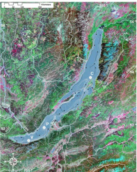
Fig. 2 Landsat TM-MOSAIC bands 742 (source: CONTINENT Baikal-GIS): the satellite map shows the Lake Baikal area, its tributaries, bathymetry, surface currents and the three CONTINENT coring sites (filled circles). C-Continent ridge (CON01-603), P-Posolskoe ridge (CON0l-604), V-Vydrino shelf (CON01-605)
Materials and methods
Assembly of data sets for the CONTINENT Baikal-GIS
In the course of the CONTINENT project and related projects, sediment core data and a variety of limnological, geophysical, sedimentological and botanical field data were acquired. The GFZ Lake Drilling Information System (LakeDIS) served as project database, its data model is compatible to the data model of
PANGAEA/WDC-MARE (Diepenbroek et al. 2002), where all data are georeferenced by coordinate pairs in decimal degrees. Latitudes and longitudes in the decimal form are commonly used in digital databases use and are calculated as decimal degrees = degrees + minutes/60 + seconds/3,600. The experience gained from the application of the LakeDIS was later used to develop the Drilling Information System for the Antarctic Coring Expedition (ACEX) of the Integrated Ocean Drilling Program (Wallrabe-Adams et al. 2006).
The CONTINENT sediment core data, field data and additional data sets from the LakeDIS database were transformed for use in a GIS database, where all geographical objects are represented as vector elements or as raster data matrices. Vector data build a model of the real world as multipoint-layers, such as the field sampling stations, and vector lines, such as ship tracks, drainage patterns, contour lines and polygon layers, such as geology, soil, vegetation, etc. On the other hand, digital elevation models (DEM), multi-spectral satellite images, and similar data, are stored as raster data, which reference parameters by grid cell location in a matrix.
GIS data are generally visualized using the same map projection in the same earth coordinate system for all data in the system. The geographically referenced datasets in decimal degrees from the LakeDIS database would have been sufficient for the visualization of the spatial data. However, to be able to calculate true lengths and areas, the coordinates were transformed to the Universal Transversal Mercator (UTM) projection. The UTM coordinate system with a true scale longitude at 105°W in UTM zone 48 on the World Geodetic System (1984) reference ellipsoid (WGS84) was chosen as map datum for the CONTINENT Baikal-GIS. Originally, all data were processed using commercial GIS and image processing software (ENVI® (RSI), ArcGIS®, Arclnfo®, ArcIMS®, IMAGINE® (ESRI)), but Open Source software, such as GRASS GIS and UMN Mapserver are also suitable tools for the operations described in this paper. The thematic layers of the CONTINENT Web-GIS can be divided into three groups:
• CONTINENT project data and data from related projects (sampling and coring positions, lacustrine sediments, bathymetric map).
• Freely available data sets from the world wide web (digital elevation model, geology, pedology, infrastructure, drainage pattern, etc.).
• Derived calculated higher level data (river catchments, litho-stratigraphic groups in the catchment, pollen distribution, distribution of plant species and plant functional groups).
The contents of the CONTINENT Web-GIS thematic layers are summarized in Tables 1, 2, 3, 4.
As a first processing step, the LakeDIS CONTINENT project data and related project data, such as thematic maps and bathymetric information, were transformed from their given coordinate systems into UTM cartesian coordinates of zone 48. Lake Baikal and its catchment expand over three UTM zones (zones 47, 48, 49), covering zone 48 as the central UTM zone, and one third of both neighbouring UTM zones, respectively. The error in area calculation for all data sets, caused by re-projecting UTM zones 47 and 49 onto zone 48, was assessed for the catchment areas. It proved to be insignificant with a value of less than 1% (Swiercz 2004).
Table 1 Project data, related projects
Theme Data Data source Data format
Ia CONTINENT cores Core locations (drilled in 2001), CON01-603 Continent, CON01-604 Posolskoe, CON0l-604 Vydrino
CONTINENT team Point ordinal data, point data n = 3
Ib CONTINENT stations Expedition stations (2001, 2002, 2003) ship cruises, land and ice expeditions
CONTINENT team Point ordinal and nominal data, point vertical profiles, vector ordinal data, point data n = 291
Ic Baikal Drilling Project (BDP) cores
BDP core locations BDP1 (1993), BDP2 (1996), BDP3 (1997), BDP4 (1999)
Baikal Drilling Project (BDP) (Russia, Japan, Germany, USA), http://www.geol.sc.edu/ SIL/bdp.htm
Point ordinal data, point data n = 4
Id Baikal sediment cores Core locations EAWAG 1996-1998 Point ordinal data, point data n = 3
Ie Eolian and fluvial sediments
Sediment samples (2002, 2003) river bed, loess
(DFG project1), M. Zopperitsch
Point ordinal data, point data n = 64
II Lacustrine sediment Lacustrine sediment map EAWAG GEOPASS 1999 Polygon nominal data III Bathymetry New bathymetrical map of
Lake Baikal
RCMG, INTAS Project 99-1669
Vector ordinal data
IV Pollen Pollen samples
(terrestrial, lacustrine)
J. Bezrukova and V. Markgraf (Bezrukova 1999)
Point ordinal and nominal data, point data n = 70
Table 2 Supporting digital spatial data available on the world wide web (selected GIS-layers)
Theme Data Data source Data format
V Topography GTOPO30 Digital Elevation Model DEM with 1 km2 grid spacing
USGS Raster ordinal data
VI Geology Digital geological data sets (Russia, Mongolia, China)
USGS Polygon nominal data
VII Hydrology GMT drainage pattern GMT Vector nominal data
VIII Hydrology DCW drainage pattern (high stream orders), DCW inland water bodies, DCW
infrastructure
ESRI Vector nominal data
IX Pedology, vegetation IIASA digital Soil and Physiographic database for North and Central Asia
FAO Vector, polygon, interval and nominal data
X Optical satellite data MrSid Landsat bands 7 4 2 NASA Raster ordinal data
Additional data from the world wide web were topographical, geo-ecological and geological, pedological and botanical thematic digital data sets. These country-related data sets from Russia, Mongolia and China were merged into single thematic map layers (Table 2), each covering an area of 1,620 × 1,760 km2 (including southern central Siberia, northern central Mongolia, part of northern China). In some cases merging datasets required the assimilation of the data attributes that partly differed between the data sets from Russia, Mongolia and China. All these data layers were also transformed on to UTM, zone 48, to allow their integration into the common spatial database. Detailed processes of data acquisition for selected thematic layers are described below.
The topographical digital elevation model (DEM) was calculated from the United States Geological Survey (USGS) topographic DEM 'GTOPO30', which offers a spatial resolution of 30 arc seconds (~1 km2). Recently, a new DEM of the earth with nearly global coverage and a spatial resolution of ~ 0.008 km has become available from the NASA Shuttle Radar Topography Mission (SRTM) mission.
Table 3 Processed digital spatial data using the CONTINENT Baikal-GIS (selected GIS-layers)
Theme Data Description/method Data source Data format
Topography Elevation contours (m)
ARC GIS Calculated from V
(Table )
Vector ordinal data
Lake Baikal catchment Lake catchment main river catchments (Selenga, Barguzin, Upper Angara) ARC VIEW
Digitized on layers stuck of DEM, elevation contours, DCW drainage pattern
Swiercz 2004 Vector nominal data
Vegetation Plant functional types PFTs
Mono-species maps Mono-PFT maps
ARC VIEW (digitized) Extraction of relative
abundance (dominant, present, absent) PFT polygons Vegetation map of (Isachenko 1990) Polygon nominal data
Pollen Pollen distribution Species maps PFT maps
ARC GIS nearest neighbour interpolation
Relative abundance of main pollen species
Rrelative abundance of grouped pollen according PFTs
Calculated from II (Bezrukova 1999) (Table 2)
Raster ordinal data
Geology Revised geology Litho- stratigraphy within the lake catchment
ARC MAP
Geochronological and litho-stratigraphical attributation
Edited from VI (Table 2) (Fagel et al. 2007)
Polygon nominal data
However, at the time of the described study, the SRTM digital elevation data were not yet released for the Mongolian and Southern Siberian areas. The GTOPO30 DEM was colour-coded to serve as topographic background information. It was also used to calculate slope angles and aspects, and elevation contour lines at 100 m intervals by triangulation. It turned out that the raster-layer of slope values calculated from the GTOPO30 dataset could not resolve the rugged mountain ranges and steeply incised valleys around Lake Baikal. Owing to the low spatial resolution, the DEM only showed elevated plateaus. Instead, Swiercz (2004) used the polygon layer 'slope' from the International Institute for Applied Systems Analysis (IIASA) dataset showing slope intervals to extract different susceptibilities to erosion. The catchment area outlines of Lake Baikal and its three main tributaries were digitized onto the combined layers of elevation contour lines and the high resolution drainage pattern accordingly hydrological considerations (Swiercz et al. 2003). Several new GIS layers were produced to estimate the proportions of parameters in the respective river catchments by clipping the
parameterized layers, e.g. 'geology', 'vegetation', 'soils', 'slope', using the vector layers 'lake catchment' and 'river catchments'.
Implementation of the CONTINENT Web-GIS service
The web-based GIS itself has a client-server architecture. On the CONTINENT website the client offers access to the Web-GIS. This application uses JavaScript to provide functionalities such as zooming into and out of the map view, selecting thematic map layers, querying feature information, etc. On the server side, the web map server receives requests to build a thematic map from selected GIS layers, and delivers the constructed map to the client as a raster image (JPEG). The web map service is conformable to the standards set by the OpenGIS® Consortium Web Map Service (WMS). The application is presently being ported from ESRI ArcIMS® to degree2, a framework of Open Source geospatial servers (http:// www.degree.org/).
On start-up, the CONTINENT Baikal-GIS shows the coloured DEM as standard map and as the reference map in the overview inset. The right-hand menu is toggled to the selection of thematic layers (e.g. geology, soils, LANDSAT satellite image mosaic, CONTINENT stations, drainage pattern, lake and river catchments, elevation contour lines). The display of map features, the associated items in the map legend, and scale bar is made scale dependent. Map features and dependent map elements are only shown at their designated scale intervals. For different map scales data layers visualize differently, e.g. the drainage pattern shows different stream orders, and contours are shown at contour intervals appropriate to the map scale. The display rules of the CONTINENT Baikal-GIS are set to avoid overlapping map elements.
A feature selection serves as a geographical query tool to display attribute information of the selected layer. Attribute tables include the sample code, its coordinates in decimal degrees and UTM, date and time of
sampling, attributed parameters, metric size of feature (length, area), and more. The attributed parameters may be nominals such as litho-stratigraphic groups, pollen species, and soil types, or ordinals, such as topographic elevations and bathymetrical depths, specific concentrations, relative abundances, etc., or intervals, such as ranges of slope or elevation values. The query tool can be used to select and highlight elements in an active map layer according to search criteria. Through the web-based CONTINENT Baikal-GIS, endusers are not able to undertake quantitative and comparative GIS-analyses. The detailed GIS-analyses presented in this study have been carried out on the workstation-based CONTINENT Baikal-GIS.
Results
Quality of data and spatial visualization
As a result, this study shows that it is useful to acquire substantial parts of the geodata from publicly available sources. Generally, most data available on the world wide web are at meso-scale resolution which would be not sufficient for local studies on a scale of 1:10,000, or higher resolution. However, given the size of our study area, the spatial resolution of the data incorporated in the CONTINENT Baikal-GIS (e.g. 100 m elevation contours, 1 km raster) and their thematic resolution were adequate for the visualization purpose. Evaluation of the quality of the downloaded digital data sets showed that the majority of the spatial thematic data acquired were consistent with investigations in the field with the thematic content of the Baikal Atlas of Galasy (1993) and in agreement with regional maps. In the course of detailed studies on geology and vegetation, it turned out that the assembled data sets from the world wide web needed editing.
Table 4 List of data publications
Theme Data Data source
CONTINENT Baikal GIS CONTINENT
Data citation: Klump J, Heim B, Schulze A, Swiercz S, Schneider S, Ziemke B, Dachnowski G, Bruhns C, Mueller M and Braune S 2007. CONTINENT Baikal Online-GIS. Scientific Drilling Database (SDDB), Potsdam, Germany. doi:10.1594/GFZ.SDDB.1202
Stations CONTINENT stations, related projects CONTINENT
Data citation:
Oberhänsli H, stations from associated pr
CONTINENT-Team, BDP-Team, EAWAG-Team and Zopperitsch M 2007.
CONTINENT stations and ejects (UTM Coordinates). SDDB, Potsdam, Germany. doi:
10.1594/GFZ.SDDB. 1203
Bathymetry New bathymetry of Lake Baikal (low resolution), high-resolution maps of CONTINENT sites
RCMG, INTAS Project 99-1669
Data citation: de Bastist M, ( Low-resolution bathymetric INTAS-map of Lake Baikal
Canals M, Sherstyankin P, Alekseevm S, Charlet F and INTAS Project 99-1669 Team 2007. map and detailed sections (CONTINENT coring sites) from the new bathymetric (2002). SDDB, Potsdam, Germany. doi:10.1594/GFZ.SDDB.1204
Lacustrine sediments Lacustrine sediment regions of Lake Baikal EAWAG, GEOPASS 1999
Data citation: Sturm M 2007. Regions of lacustrine sediments in Lake Baikal (Geochemistry, Particle Formation and Sediment Sources of Lake Baikal, GEOPASS-project). SDDB, Pots, G. doi:10.1594/GFZ.SDDB.1205
Topography Digital elevation model DEM (physical values, topographic shadings, elevation contour lines)
USGS
Data citation: US Geological Survey USGS (Earth Resources Observation Systems EROS) 2007. Topographical data sets of the Lake Baikal region (digital elevation model and elevation countour lines); calculated from the USGS GTOPO30 DEM data. SDDB, Potsdam, Germany. doi:10.1594/GFZ.SDDB.1206
Infrastructure Borders, railroads, roads, settlements DCW
Data citation: Digital Chart of the World DCW 2007. Infrastructure of the Lake Baikal region (rail, road, settlements, borders). SDDB, Potsdam, Germany. doi:10.1594/GFZ.SDDB.1207
Hydrology Drainage pattern (high stream orders), inland water bodies
DCW
Data citation: Digital Chart of the World DCW 2007. Hydrology of the Lake Baikal region (drainage pattern, inland waters). SDDB, Potsdam, Germany. doi:10.1594/GFZ.SDDB.1208
Hydrology Main drainage pattern GMT
Data citation: Generic Mapping Tools GMT 2007. Drainage pattern of the Lake Baikal region. SDDB, Potsdam, Germany. doi: 10.1594/GFZ.SDDB.1209
Hydrology Lake Baikal catchment with main tributaries Swiercz (2004)
Data citation: Swiercz S 2007. Lake Baikal catchment (lake catchment, catchments of main tributaries). SDDB, Potsdam, Germany. doi:10.1594/GFZ.SDDB.1210
Geology Geological provinces, geochronology USGS polygons, new attribution
Data citation: Heim B, Klump J, Schulze A, Dachnowski G and Schneider S 2007. Geology of the Baikal region. SDDB, Potsdam, Germany. doi:10.1594/GFZ.SDDB.1211
Pedology Pedology FAO
Data citation: Food and Agriculture organization of the United Nations FAO 2007. Pedology of the Baikal region. SDDB, Potsdam, Germany. doi:10.1594/GFZ.SDDB.1212
Geology Litho-stratigraphy of the lake Baikal catchment USGS polygons, new attribution
Data citation: Heim B, Klump J, Schulze A, 2007. Litho-stratigraphy of the lake Baikalcatchment. SDDB, Potsdam, Germany. doi:10.1594/GFZ.SDDB.1213
Fig. 3 Screen-shot of the CONTINENT Web GIS HTML-client (degree2), as shown in a web browser. The colour-coded digital elevation model is overlain by vector-layers of the infrastructure, elevation contour lines, drainage pattern, CONTINENT stations and lacustrine sediment regions. The enlarged view provides detailed information on the Selenga Delta area
Before we provide examples of GIS-solutions related to research questions, we would like to point out the advantage of the CONTINENT Baikal-GIS as a mapping and visualization tool. (Small-scale) maps provide an overview on sample distribution, drainage pattern, topography and thematic information. Zooming to higher map scales provides maps of high spatial resolution. Figure 3 shows a large-scale map of the Selenga Delta area with the coloured DEM as chosen background. It is overlain with the polygon layers of Lake Baikal's lacustrine sediment regions (Sturm et al. 1998), the point layer of the CONTINENT sampling stations and the vector layers of infrastructure and elevation contour lines. The web-based GIS can be queried for specific parameters, or for codes of sampling positions. The CONTINENT Baikal-GIS allows an immediate interpretation of samples in their spatial context, i.e. their sedimentary, botanical, and geomorphologic environment, by using the thematic maps and the query functionalities provided by the Web-GIS client. Also, the conventional printed maps that were available to us covered the study area only incompletely and the Baikal-GIS thematic maps became a valuable orientation tool for interpreting field data.
Application of GIS in sediment provenance analyses
In lakes, the mineral composition of the sediments is significantly more influenced by the local catchment geology and soil composition than in marine environments (Boyle 2004). Lomonosov et al. (2001) studied the relations of the composition of the solid runoff of large rivers in selected petrological provinces at Lake Baikal characterized by their heavy mineral fractions. Horiuchi et al. (2000), Kasik and Mazilov (1997) and Sakai et al. (2005) discussed the main lithologies of the Buguldeika catchment area (Precambrian granitoid-gneiss rocks) to associate them with their investigations on mineral assemblages and weathering stages of clays in the BDP-long core 93.
For the CONTINENT cores, Fagel et al. (2007) analysed the mineralogical composition of the lake sediments to characterize the sources of terrigenous particles during the Late Quaternary. The three CONTINENT piston cores were recovered on isolated bathymetric highs in the North and South Basins of Lake Baikal (Fig. 2) (Charlet et al. 2005). Piston core CON01-603 was retrieved on Continent Ridge, a structural high north off the Suvyatoi Nos Peninsula along the eastern coast of the North Basin. Piston core CON01-604 was retrieved on the Posolskoye Bank, a tilted fault block within the Selenga Delta Accommodation Zone part of South Baikal. Piston core CON01-605 was retrieved on the slope terrace of the Vydrino Shoulder in the South Basin. The age models for the sediment cores (Demory et al. 2005; Piotrowska et al. 2004) are based on AMS 14C dates derived from pollen concentrates, diatom zonation, and correlation of the magnetic record with a magnetostratigraphic standard curve. The cores measured 6-10 m in length and cover the last 40 kyr at Vydrino, 60 kyr at Posolskoye and 185 kyr at Continent Ridge. The sediments are alternating biogenic diatom-rich muds and terrigenous silty clays. The mineralogical investigation (Fagel et al. 2007) showed that in two cores, CON01-604
from Posolskoye Bank in the South Basin, and CON01-603 from the Continent site in the North Basin, clay mineral composition (mainly illite and smectites), light and heavy mineral compositions (mainly quartz and feldspars; heavy mineralogical composition dominated by hornblende) are very similar even though these cores were taken at sites that are 300 km apart and in different deep lake basins. In contrast, the mineral assemblage of CON01-605 from the Vydrino shoulder, which is also located in the South Basin, ~ 80 km from the Posolskoye site (CON01-604), shows a very different composition in the light and heavy mineral fractions and in the clay composition. The sediments show a major abundance of micas in the light mineral fraction, whereas tourmaline, rutile, apatite and zircon do not occur in the heavy mineral composition. The illite-smectite ratio is distinctively high due to the high illite content (up to 80%).
The GIS-layers were assessed to calculate the area and relative abundance of the main lithologies. Despite their richness in detail, the digital geological map data could not be used without extensive editing. Differences in the attribution between the map datasets of Russia and Mongolia resulted in a considerable underestimate of the presence of granitoids in the Selenga catchment, even though the granitoids are dominant features in this area (e.g. Sayan-volcanic-plutonic belt, Mongol-Okhotsk granitoid zone) (Jansin et al. 1989; Kalinin and Moiseeva 1981). The chronostratigraphic attributions of the integrated digital geological maps (doi:10.1594/
GFZ.SDDB.1210) still lacked comprehensive mineralogical information that is needed for the analysis of sediment provenance. Therefore, new digital geological map data were produced (doi:10.1594/
GFZ.SDDB.1210, Fig. 4) by re-grouping and re-attributing lithological parameters according printed geological maps (Table 5). Along the south-east coast of Lake Baikal, where the Vydrino site (CON01-605) is located, Precambrian high-meta-morphic rocks with topped Paleogen/Neogene sediments inherent the lithological polygons. These rocks supply the light and heavy mineral composition of non granitoid-type to site. The general constellation of lake currents in Lake Baikal (Fig. 2 after Galasy 1993) visualizes that the terrigenous input by the Selenga River is blocked by a counter-clockward eddy south of the Selenga Delta and cannot be transported southwards along the eastern coast.
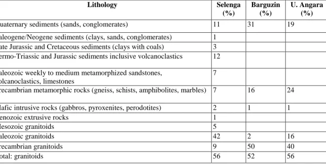
The area and relative percentage of the main source rocks within the river catchment areas were calculated for the catchment areas of the Selenga, Upper Angara and the Barguzin rivers (Table 6). The area calculation indicated a granitoid coverage exceeding 50% of the river catchments. The second important lithological group in the river basins are Quaternary sediments (11-31% coverage). In most cases Quaternary sediments are found in the tectonic sub-basins of granitoid provinces and are therefore assumed to be composed mainly of reworked granitoid. This prevalence of granitoid source rocks strongly influences the sediment composition at sites CON01-603 and CON01-604, even though the two positions are hundreds km apart and located in different sub-basins of Lake Baikal.
Application of GIS in palynological analyses
For the interpretation of pollen assemblages it is essential to take into account the differences in taphonomic factors between large lake basins and small enclosed lake basins (McCarthy et al. 2007). The pollen distribution is controlled by the surrounding vegetation. In addition, in large lakes, major tributaries serve as concentrated sources, and sedimentation and erosion occurs highly differentiated.
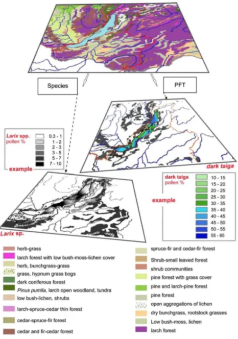
GIS tools were used to create maps for the comparison of the pattern of present-day vegetation with modern pollen distribution. Vegetation data available on the world wide web was to coarse in its spatial resolution. Digital vegetation data acquired from the United Nations Food and Agriculture Organization (FAO) were more differentiated in their spatial resolution. However, in the FAO dataset, the outlined boreal areas were attributed as 'forest' in terms of land-use and not further sub-classified into forest types. In addition, significant areas of forest-steppe and steppe that do exist in the taiga dominated Baikal region were not represented, e.g. the large area of the steppe-dominated Olkhon Island (precipitation 160 mm a-1, Galasy 1993) was classified as taiga. Thus, we were not able to obtain free digital data of adequate spatial and thematic resolution for the purpose of this application. Instead, a detailed Russian map of vegetation units (Isachenko 1990) served as the base for a new digital vegetation map. The map was digitized and the resulting polygon-layer georeferenced to the CONTINENT Baikal-GIS map datum (UTM zone 48, WGS 84). This polygon GIS-layer can be separated to produce digital vegetation maps showing mono-plant functional type (PFT) and mono-species (S) distribution (Fig. 5). Mono-PFT maps were deduced by choosing the respective PFT attribution and exporting the selection as new polygon-layer. Mono-S maps were produced by additional attributions describing the relative abundance of respective plant species (i.e. dominant, present, absent).
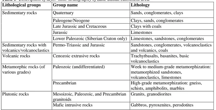
Fig. 4 Screen-shot of the thematic GIS-Layer 'litho-stratigraphy of the Lake Baikal catchment' (doi:10.1594/ GFZ.SDDB.1213). The colour legend below describes the litho-stratigraphic groups
Table 5 Description of layer 'litho-stratigraphy of Lake Baikal catchment area'
Lithological groups Group name Lithology
Sedimentary rocks Quaternary Sands, conglomerates, clays
Paleogene/Neogene Clays, sands, conglomerates Late Jurassic and Cretaceous Clays with coals
Jurassic Limestones
Lower Paleozoic (Siberian Craton only) Limestones, sandstones, conglomerates Sedimentary rocks with
volcanics/volcanoclastics
Permo-Triassic and Jurassic Sandstones, conglomerates, volcanoclastics and volcanics, coals
Volcanic rocks Cenozoic extrusive rocks Trachytbasalts, basanites, basic volcanoclastics
Metamorphic rocks (of various grades)
Paleozoic (undifferentiated) Week to medium-grade metamorphization: metamorphized sandstones,
volcanoclastics, limestones
Precambrian High-grade metamorphization: gneiss,
schists, amphibolits, marbles Plutonic rocks Mesoizoic, Paleozoic, and Precambrian
granitoids
Granits, granodiorites
Table 6 Relative cover of the main stratigraphic lithologies in the Selenga, Barguzin and Upper Angara catchment areas (see also Fagel et al. 2007)
Lithology Selenga (%) Barguzin (%) U. Angara (%)
Quaternary sediments (sands, conglomerates) 11 31 19
Paleogene/Neogene sediments (clays, sands, conglomerates) 1 Late Jurassic and Cretaceous sediments (clays with coals) 3 Permo-Triassic and Jurassic sediments inclusive volcanoclastics 12
Paleozoic weekly to medium metamorphized sandstones, volcanoclastics, limestones
7
Precambrian metamorphic rocks (gneiss, schists, amphibolites, marbles) 7 16 24
Mafic intrusive rocks (gabbros, pyroxenites, perodotites) 2 1 1
Cenozoic extrusive rocks 1
Mesozoic granitoids 5
Paleozoic granitoids 42 2 16
Precambrian granitoids 9 50 40
Total: granitoids 56 52 56
Pollen data from Lake Baikal sediments and surface samples on land were supplied by V. Markgraf and Y. Bezrukova (Bezrukova 1999). The pollen data were grouped to match the classification into PFTs used in the vegetation map of Isachenko (1990). All georeferenced pollen data (percentages of species taxa or functional groups, respectively) were interpolated to model the pollen distribution pattern in the lake sediments in Lake Baikal. Using natural nearest neighbours method that is based on Thiessen polygon calculation (Tabios and Salas 1985) prevented over-smoothing between the irregularly distributed sampling stations.
Mono-PFT maps and mono-S maps (dominant, present, absent) were compared with the modern distribution of their pollen in the lake and its vicinity. Generally, distribution pattern of selected plant species and their respective quantitative pollen distribution showed a mismatch. As an example, the proportion of P. sylvestris pollen grains, where present, exceeded the proportion of the recent coverage of P. sylvestris within the catchment area that are only moderate abundant, concentrated in the northern Selenga and in the Barguzin catchment areas. In contrast, Larix spp. are abundant in the entire lake catchment area, but the pollen grains were
underrepresented in the pollen assemblages. The highest proportion of Larix spp. pollen was found of the Selenga Delta and in Barguzin Bay, where the Barguzin River enters into Lake Baikal. On the other hand, in the Upper Angara Valley, an area with abundant Larix spp. forests, the relative proportion of Larix spp. in pollen assemblages was low, even in surface samples taken.
The visualization of pollen distribution as mono-S maps illustrates that the main mode of dispersion for the pollen of Pinus sylvestris is wind transport, while the pollen of Larix spp. are dispersed by water transport in rivers and within the lake by lake surface currents (Bezrukova 1999), evident by the higher concentrations of
Larix spp. pollen grains in sediments around the Selenga Delta and in Barguzin Bay. In contrast to mono-S
maps, the comparison of pollen groups with vegetation maps of PFTs, the disparity between plant distribution on land and pollen distribution in the lake was not as pronounced. Klump and Schneider (2004) in their GIS study concluded that grouping pollen according to PFTs gave a better representation of environmental conditions on land, than using pollen data on species level.
Grouping pollen taxa into PFTs and biome classification for paleoclimate investigation was introduced for Northern and Central Asia by Tarasov et al. (1998, 2000) who successfully used the biomization method on very large data sets. By grouping pollen taxa into PFTs, Demske et al. (2005), Granoszewski et al. (2005) and Tarasov et al. (2005), reconstructed paleovegetation and climate from sediments in CONTINENT kasten cores from North Basin and South Basin. The kasten cores were retrieved at the same sites as the CONTINENT piston cores and can be correlated with the piston cores. Demske et al. (2005) and Tarasov et al. (2005) conclude that the paleoenvironmental signals in their sedimental records of Lake Baikal comprehensibly reflect large-scale vegetation and climate changes.
Fig. 5 Schematic diagram of the assembly of new vegetation maps from the GIS-layer 'vegetation' after (Isachenko 1990). Maps of plant functional types (PFT maps) and maps of relative plant species distribution (species maps) are created to show the vegetation distribution in comparison with the respective pollen distribution. The colour legend below describes the PFTs
Publishing and sharing geodata from the CONTINENT Baikal-GIS
All thematic map layers discussed in this paper are published as data publications through the Scientific Drilling Database. Each dataset is identified persistently and globally unique by a Digital Object Identifier (DOI), which can be resolved to a Uniform Resource Locator (URL) through any Handle.Net server. To facilitate discovery of the data by users not aware of their existence, all data publications in this paper are listed as electronic sources in the online catalogue of the German National Library of Science and Technology (TIB/UB Hannover, Hannover, Germany). Table 4 shows how the data are listed.
All data may be downloaded from the Scientific Drilling Database and used for new scientific works. The use of the data by other authors is governed by the Creative Commons licence (by-nc, 2.0, de), which allows the author to create derivative works, as long as the derivative works are non-commercial and the origin of the data is acknowledged, i.e. a proper citation is given. Thus, data publications are treated in analogy to 'traditional' publications.
Discussion
This study presents a meso-scale GIS database, whose data are related to a paleolimnological project.
Traditionally, analogue conventional information existed in form of printed maps or atlases. These, however, are static and come in a multitude of geographic projections and spatial scales. Within a GIS, through
georeferencing, digital maps can be produced from heterogeneous quantitative and descriptive data. The data visualisation-on one hand showing spatial interrelationships, on the other thematic background information-enables the interpretation of data in their spatial context and on different spatial scales. Data can be extracted through queries and spatial analysis can be used for limnological, geological, botanical and pedological investigations.
The two presented examples, (1) the sediment provenance study and (2) the comparison of the modern plant and pollen distribution show that GIS provides visualization of a multitude of data and spatial dimensions. (1) In many cases it proves to be difficult to determine the geology of large catchment areas crossing national borders from printed geological maps. Often, printed geological maps do not show elevation contours that would be needed to outline the fluvial catchments. The large number of spatial scales and map projections makes it technically difficult to transfer data, e.g. catchment outlines, from one map to the next. It is for cases like this, that GIS tools provide a solution to integrate spatial data across various scales. In future applications in this study, the lithology could be displayed in combination with other thematic map data, e.g. soil types, modern precipitation rates, slope angles and exposure, vegetation cover, or topographic height. The integration of spatial data helps to gain a detailed insight into processes in the catchment area and allows quantitative spatial analyses. However, evaluation of data accuracy and validity remains important, in particular in the case of data retrieved from the world wide web. (2) The distribution and composition of modern vegetation and the morphology are spatial parameters that can be visualized with GIS-methodology. The differences in taphonomic factors are considerable for large lakes such as Lake Baikal, and information on modern vegetation may be incorporated in various ways. For example, Demske et al. (2005) used information on altitudinal vegetation zones to interpret the pollen assemblages in the sediment core. The GIS-visualization of vegetation described in this paper is of lower spatial resolution. In reality, the composition of the plant communities in the mountainous Baikal region is highly differentiated according the elevation and the slope exposure. Humid, western slopes are covered by dark-needled taiga forests whereas the dryer east-facing slopes are covered by the light taiga forests (Bezrukova 1999). Deciduous trees usually form secondary forests after taiga fire. Towards the south to Mongolia, steppe communities occur on the eastern and southern slopes of the Baikal ranges (Dulamsuren et al. 2005). Future GIS visualization may incorporate processed satellite data (e.g. PFTs calculated from multispectral satellite image classification) and SRTM-DEM data altogether for a more detailed representation of vegetation biotypes, such as they are currently produced within remote sensing research projects (e.g. Siberia-II, http://www.siberia2. uni-jena.de/index.php).
Local Russian governmental GIS databases, as well as GIS databases by Russian and Buryatian research institutes and from international projects (e.g. Siberia-II, INTAS GIS Baikal, Selenga Delta) hold valuable and detailed local GIS databases of the Baikal region. Within the EU-project 'Irkutsk Regional Information System for environmental protection, IRIS', the existing GIS data of the Irktusk region are compiled and completed into an operative prototype for other regions of Northern Eurasia. The focus of IRIS lies on environmental hazards and management strategies. Data have not yet been exchanged between CONTINENT and the afore mentioned projects, because the areas covered by these projects mainly extended north-west of Lake Baikal towards the boreal regions and were studies of high spatial resolution. Whereas, this GIS-database has a meso-scale resolution, and also incorporates large areas from northern Mongolia, located to the south of Lake Baikal.
Despite being a project-related GIS, the majority of the map layers provided by the web-GIS were created by using freely available data sets from the world wide web. There is a variety of useful geodata sets available that still remain underutilised. The move by academic and research institutions to create open access to knowledge has started a discussion on open access to data (Klump et al. 2006). However, open access to data seems unlikely before the work of data authors is acknowledged by citation of their data in the scientific literature. For data to be citable it is necessary that they can be referred to in a persistent way. The location of Internet resources, and thus their URL, may easily change, which in most cases means to the user that the data are lost (Koehler 2004; Lawrence et al. 2001). Therefore, a prerequisite for data access via the Internet is the use of persistent identifiers, such as DOI, to be able to locate the desired dataset over a long time by its name, irrespective of its current URL (Brase 2004; Paskin 2005). Also, geospatial data cannot be found systematically on the world wide web because they are normally not listed in library catalogues or scientific literature databases. The project 'Publication and Citation of Scientific Data' (STD-DOI) has established a system by which data are published through accessible databases, identified by persistent identifiers (DOI) and incorporated in the catalogue of the German National
Library for Science and Technology (TIB Hannover). The data publications are citable, accessible and can be discovered through the TIB library catalogue by other users.
Conclusions
Applications of GIS technology in the paleoclimate project CONTINENT on Lake Baikal (Siberia, Russia) shows that it is useful to include the spatial dimension of data in paleolimnological projects. GIS methodology was the tool for getting georeferenced and spatial information from parameters. The CONTINENT Baikal-GIS offers web-based access to various thematic data on the study area around Lake Baikal. Even though the CONTINENT Baikal-GIS was intended only as a prototype, it has been operational and fully accessible to the public since 2002.
A substantial part of the CONTINENT Baikal-GIS layers were produced from freely available spatial data sets retrieved from the world wide web. Evaluation and re-attribution of geodata allowed us to produce higher level derivative thematic map layers. This evaluation of the accuracy and validity of the available data, and the assessment of their use for specific scientific questions is considered as an important task.
The GIS data layer 'Lithology of the Lake Baikal catchment' was produced as part of a study on sediment provenance. Lake sediments in piston cores showed similar heavy and light mineral composition and clay composition, despite being taken 300 km apart in different deep lake sub-basins. The quantification of lithologies in the catchment of Lake Baikal showed a remarkable lithological homogeneity of the main tributary catchments of Lake Baikal. In contrast, CONTINENT cores from the southern lake sub-basin differed in their mineralogical composition due to geological variations along the lake shoreline.
The distribution of pollen and plant was visualized using GIS-methodology by calculating distribution maps of pollen and vegetation grouped by taxa and by PFT. The comparison of pollen distribution and vegetation taxa distribution showed spatial discrepancies. These discrepancies were foreseeable, because taphonomic factors of pollen deposition in a large lake are highly variable. Grouping pollen and vegetation taxa according PFTs gave a better spatial agreement of the modern vegetation distribution and pollen deposition, than mono-specific plant and pollen distribution maps.
A novel feature is the publication of the GIS data presented in this paper through the Scientific Drilling Database. The data publications can be located through DOI. Reliable access allows the data to be cited like 'traditional' scientific publications. Data publications can be discovered by other scientists through online catalogue of the German National Library for Science and Technology and, in future, other discipline specific data portals. This novel approach to data publication opens an entirely new dimension of data acquisition, sharing and dissemination.
Acknowledgements
The project 'High Resolution CONTINENTal Paleoclimate Record in Lake Baikal, Siberia' was supported by the European Commission under the Fifth Framework Programme (Contract EVK2-2000-00057). The project 'Publication and citation of scientific and technical data' is supported by the German Science Foundation, Div. Libraries and Information Systems (LIS4-55495(1) Hamburg BIB 46 Hhmpi 01). B. Heim gratefully
acknowledges support by the 'Program for Equal Opportunities for Women in Research' granted by the Senate of Berlin, Germany. We would like to thank E. Thamó-Bózsó, Geological Institute of Hungary for the heavy mineral analysis. We are grateful to S. Swiercz from the hydrogeological working group of Prof. Peckdeger (Free University of Berlin, Germany) and S. Schneider, A. Schulze, G. Dachnowski, F. Kramer, P. Burgess and the technical staff of the GeoForschungsZentrum Potsdam Data Centre for their contributions to the Baikal GIS. We are also indebted to two anonymous reviewers for their reviews and suggestions which improved this manuscript.
Appendix 1
Acronyms
DCW Digital Chart of the World (ESRI product) 1
DFG Deutsche Forschungsgesellschaft (German Science Foundation); project 'Chemical, isotopic, and mineralogical proxy data for eolian input into the Lake Baikal system during the last 150 ka'
EAWAG Swiss Federal Institute for Environmental Science and Technology, Switzerland
ESRI Environmental Systems Research Institute
FAO Food and Agriculture organization of the United Nations
GEOPASS Geochemistry, Particle Formation and Sediment Sources of Lake Baikal
GMT Generic Mapping Tools
IIASA International Institute for Applied Systems Analysis
INTAS International Association for the promotion of cooperation with scientists from the New Independent States of the former Soviet Union
RCMG Renard Centre of Marine Geology, Ghent, Belgium
USGS United States Geological Survey
Appendix 2
DOIs are resolved to URLs through any Handle.Net server. DOI-Prefixes are listed under http://dx.doi.org/. Use, for example, http://dx.doi.org/10.1594/GFZ. SDDB.1202/.
References
Alexander W, Berlin J, Cyr P, Schofield A, Piatt L (2004) Realities at the leading edge of research-good practice and proper conduct in research pay off, scientifically and economically. EMBO Rep 5:324-329
Bezrukova YV (1999) Paleogeography of Pribaikalia in the postglacial and Holocene (Paleogeografia Pribaikalya v Pozdnelednikovye i Golotsenye). Novosibirsk Nauka, Novosibirsk, Russia, p 129 (in Russian)
Boyle JF (2004) Inorganic geochemical methods in paleolim-nology. In: Last WM, Smol JP (eds) Tracking environmental change using lake sediments. Physical and geochemical methods, Kluwer, Dordrecht, pp 83-141
Brase J (2004) Using digital library techniques-registration of scientific primary data. Lect Notes Comp Sci 3232: 488-494
Butler D (2006) Virtual globes: the web-wide world. Nature 439:776-778
Charlet F, Fagel N, de Batist M, Hauregard F, Minnebo B, Meischner D, The SONIC Team (2005) Sedimentary dynamics on isolated highs in Lake Baikal: evidence from detailed high-resolution geophysical data and sediment cores. Glob Planet Change 46:125-143
Delvaux D, Stapel R, Petit C, Levi K, Miroshnichenko A, Ruzhich V, San'kov V (1997) Paleostress reconstructions and geodynamics of the Baikal region, Central Asia, Part 2: Cenozoic rifting. Tectonophysics 282:1-38
Demory F, Nowaczyk NR, Bluszcz A, Demske D, Gran-oszewski W, Witt A, Oberhànsli H (2005) High-resolution magnetostratigraphy of late quaternary sediments from Lake Baikal, Siberia: age models and time lag between marine and intracontinental climatic responses. Glob Planet Change 46:167-186
Demske D, Heumann G, Granoszewski W, Nita M, Mamakowa K, Tarasov PE, Oberhänsli H (2005) Late glacial and Holocene vegetation and regional climate variability evidenced in high-resolution pollen records from Lake Baikal. Glob Planet Change 46:255-279
environmental sciences. Comput Geosci 28:1201-1210
Dulamsuren C, Hauck M, Muehlenberg M (2005) Vegetation at the taiga forest-steppe borderline in the western Khentey Mountains, northern Mongolia. Ann Bot Fenn 40:411-426
Ermakov N, Cherosov M, Gogoleva P (2002) Classification of ultracontinental boreal forests in central Yakutia. Folia Geobot 37:419-440
Fagel N, Thamo-Bózsó E, Heim B (2007) Mineralogical signatures of Lake Baikal sediments: Sources of sediment supplies through Late Quaternary. Sediment Geol 194:37-59
Fersman AY (1926) Mongol-Okhotsk metallic belt. Surf Bow 4:28-38
Fietz S, Nicklisch A (2004) An HPLC analysis of the summer phytoplankton assemblage in Lake Baikal. Freshw Biol 49:332-345
Fietz S, Nicklisch A, Oberhänsli H (2007) Phytoplankton response to climate changes in Lake Baikal during the
Holocene and Kazantsevo Interglacials assessed from sedimentary pigments. J Paleolimnol 37:177-203
Fietz S, Sturm M, Nicklisch A (2005) Flux of lipophilic pho-tosynthetic pigments to the surface sediments of Lake Baikal. Glob Planet Change 46:29-44
Flower RJ (1998) Paleolimnology and recent environmental change in Lake Baikal: an introduction and overview of interrelated concurrent studies. J Paleolimnol 20:107-117
Flower RJ, Ryves D, Battarbee RW, Mueller J, Sturm M (1999) Lake Baikal: some topical aspects of current research. J Paleolimnol 22:223-224
Galasy GI (1993) Baikal Atlas. Russ. Acad. of Sciences, Moscow, p 160
Granoszewski W, Demske D, Nita M, Heumann G, Andreev AA (2005) Vegetation and climate variability during the Last Interglacial evidenced in the pollen record from Lake Baikal. Glob Planet Change 46:187-198
Heim B, Oberhänsli H, Fietz S, Kaufmann H (2005) Variation in Lake Baikal's phytoplankton distribution and fluvial input assessed by SeaWiFS satellite data. Glob Planet Change 46:9-27
Horiuchi K, Minoura K, Hoshino K, Oda T, Nakamura T, Kawai T (2000) Palaeoenvironmental history of Lake Baikal during the last 23000 years. Paleogeogr Paleocli-matol Paleoecol 157:95-108
Hutchinson DR, Golmshtok AJ, Zonenshain LP, Moore TC, Scholz CA, Klitgord KD (1992) Depositional and tectonic framework of the rift basins of Lake Baikal from multichannel seismic data. Geology 20:589-592
Isachenko TI (1990) Vegetation of the USSR. Government Administration for Geodesy and Cartography, Moscow, USSR (in Russian)
Jansin AL, Zajcev IS, Kovalenko VI, Juvsandanzan B, Lus-ickiy IV, Jarmolyuk VV (1989) Map of geological formations of Mongolia. Government Administration for Geodesy and Cartography, Moscow, USSR (in Russian)
Kalinin VA, Moiseeva EG (1981) Petrological map of geological formations of the USSR. In: Sciences RAO (ed) Geological ministry of USSR. USSR, Moscow (in Russian)
Karabanov EB, Propenko AA, Williams DF, Khursevich GK (2000) Evidence for mid-Eemian cooling in continental climatic record from Lake Baikal. J Paleolimnol 23:365-371
Kasik SA, Mazilov VN (1997) Lithology of Quaternary sediments of the borehole sections in the catchment area of Lake Baikal. Litol Polezn Iskop 5:484-491 (in Russian)
Klump J, Bertelmann R, Brase J, Diepenbroek M, Grobe H, Hoeck H, Lautenschlager M, Schindler U, Sens I, Wa-echter J (2006) Data publication in the open access initiative. Data Sci J 5:79-83
Klump J, Schneider S (2004) Anwendung von GIS für den vergleich der regionalen vegetation mit der verteilung von pollen im Baikalsee. In: Strobl J, Blaschke T, Griesebner G (eds) Angewandte geoinformatik 2004-16 AGIT, Salzburg, Austria. Herbert Wichmann Verlag, Heidelberg, pp 354-358
Koehler W (2004) A longitudinal study of Web pages continued: a report after six years. Inf Res 9
Lawrence S, Coetzee F, Glover E, Pennock D, Flake G, Nielsen F, Krovetz R, Kruger A, Giles L (2001) Persistence of web references in scientific research. IEEE Comput 34:26-31
solid runoff of big rivers in the Baikal catchment basin. Geol Geofiz 42:278-297 (in Russian)
Lyon SW, Lembo AJ, Walter MT, Steenhuis TS (2006) Internet mapping tools make scientific applications easy. EOS Trans 87:386
McCarthy FMG, McAndrews JH, Blasco SM, Tiffin SH (2007) Spatially discontinuous modern sedimentation in Georgian Bay, Huron Basin, Great Lakes. J Paleolimnol 37:453-470
O'Sullivan PE, Heathwaite A, Appleby PG, Brookfield D, Crick MW, Moscrop C, Mulder T, Vernon N, Wilmshurst JM (1991) Paleolimnology of Slapton Ley, Devon, UK. Hydrobiologia 214:115-124
Oberhànsli H, Mackay AW (2005) Introduction to 'Progress towards reconstructing past climate in Central Eurasia, with special emphasis on Lake Baikal'. Glob Planet Change 46:1-7
Paskin N (2005) Digital object identifiers for scientific data. Data Sci J 4:12-20
Pienitz R, Smol JP (1993) Diatom assemblages and their relationship to environmental variables in lakes from the boreal forest-tundra ecotone near Yellowknife, Northwest Territories, Canada. Hydrobiologia 269-270:391-404
Piotrowska N, Bluszcz A, Demske D, Granoszewski W, Heumann G (2004) Extraction and AMS radiocarbon dating of pollen from Lake Baikal sediments. Radiocarbon 46:181-187
Rylkov VF (1996) Forest fires in the eastern Trans-Baikal Region and elimination of their consequences. In: Goldammer JG, Furyaev VV (eds) Fire in ecosystems of boreal Eurasia. Kluwer, Dordrecht, pp 219-226
Sakaguchi A, Yamamoto M, Sasaki K, Kashiwaya K (2006) Uranium and thorium isotope distribution in an offshore bottom sediment core of the Selenga Delta, Lake Baikal, Siberia. J Paleolimnol 35:807-818
Sakai T, Minoura K, Soma M, Tani Y, Tanaka A, Nara F, Itoh N, Kawai T (2005) Influence of climate fluctuation on clay formation in the Baikal drainage basin. J Paleolimnol 33:105-121
Sapota T, Aldahan A, Al-Aasm IS (2006) Sedimentary facies and climate control on formation of vivianite and siderite microconcretions in sediments of Lake Baikal, Siberia. J Paleolimnol 36:245-257
Schnurrenberger DW, Kelts KR, Johnson TC, Shane LCK, Ito E (2001) National lacustrine core repository (LacCore). J Paleolimnol 25:123-127
Soma Y, Tani Y, Soma M, Mitake H, Kurihara R, Hashmoto S, Watanbe T, Nakamura T (2007) Sedimentary steryl chlorin esters (SCEs) and other photosynthetic pigments as indicators of paleolimnological change over the last 28,000 years from the Buguldeika Saddle of Lake Baikal. J Paleolimnol 37:163-175
Straskrabova V, Izmest'yeva LR, Maksimova EA, Fietz S, Nedoma J, Borovec J, Kobanova G I, Shchetinia EV, Pislegina EV (2005) Primary production and microbial activity in the euphotic zone of Lake Baikal (Southern Basin) during late winter. Glob Planet Change 46:57-73
Sturm M, Vologina EG, Levina OV, Flower RJ, Ryves DB, Lees JA (1998) Hemipelagic sedimentation and turbidites in the active tectonic basin of Lake Baikal. INTAS Active Tectonic Continental Basins-Interaction between sedimentary and structural processes, Gent, Belgium, pp 33-34
Swann GEA, Mackay AW (2006) Potential limitations of biogenic silica as an indicator of abrupt climate change in Lake Baikal, Russia. J Paleolimnol 36:81-89
Swiercz S (2004) Charakterisierung des Baikalsee Einzugsgebietes (Sibirien) unter Anwendung von GIS-Analysen. Free University of Berlin, Germany
Swiercz S, Heim B, Pekdeger A, Oberhänsli H (2003) GIS supported characterization of the Lake Baikal catchment area. In: Proceedings of the international symposium environment change central Asia: climate, geodynamics, evolution, human impact. Free University of Berlin, Berlin, Germany, pp 116-118
Tabios IGQ, Salas JD (1985) A comparative analysis of techniques for spatial interpolation of precipitation. Water Resour Bull 21:365-380
Tarasov PE, Granoszewski W, Bezrukova E, Brewer S, Nita M, Abzaeva A, Oberhänsli H (2005) Quantitative reconstruction of the last interglacial vegetation and climate based on the pollen record from Lake Baikal, Russia. Clim Dyn 25:625-637
Tarasov PE, Volkova VS, Webb IT, Guiot J, Andreev AA, Bezusko LG, Bezusko TV, Bykova GV, Dorofeyuk NI, Kvavadze EV, Osipova IM, Panova NK, Sevastyanov DV (2000) Last glacial maximum biomes reconstructed from pollen and plant macrofossil data from Northern Eurasia. J Biogeogr 27:609-620
Tarasov PE, Webb T III, Andreev AA, Afanas'eva NB, Berezina NA, Bezusko LG, Blyakharchuk TA, Bolikhovskaya NS, Cheddadi R, Chernavskaya MM, Chernova GM, Dorofeyuk NI, Dirksen VG, Elina GA, Filimonova LV, Glebov FZ, Guiot J, Gunova VS, Harrison SP,
Jolly D, Khomutova VI, Kvavadze EV, Osipova IM, Panova NK, Prentice IC, Saarse L, Sevastyanov DV (1998) Present-day and mid-Holocene biomes reconstructed from pollen and plant macrofossil data from the former Soviet Union and Mongolia. J Biogeogr 25:1029-1053
Wallrabe-Adams H-J, Huber R, Klump J, Conze R, Graham C, Krysiak F (2006) Joint ICDP and IODP data management for MSP expeditions. In: Deutsche Forschungsgemeinschaft DFG (ed) IODP-ICDP 2006. Greifswald, Germany
Williams DF, Peck J, Karabanov EB, Propenko AA, Krav-chinsky V, Kuzmin MI (1997) Lake Baikal record of continental climate response to orbital insulation during the past 5 million years. Science 278:1114-1117
Zonenshain LP, Kuzmin MI, Napatov LM (1990) Geology of the USSR: a plate-tectonic synthesis. Stanford University, Stanford, USA, p 242