Shape and amount of the Quaternary uplift of the western Rhenish shield and the
Ardennes (western Europe)
A. Demoulin
a,b,⁎
, E. Hallot
aa
Univ. Liège, Belgium
bFNRS Belgium
a b s t r a c t
a r t i c l e i n f o
Article history:
Received 10 September 2008 Received in revised form 13 May 2009 Accepted 20 May 2009
Available online 29 May 2009 Keywords:
Intraplate tectonics
Rhenish shield Quaternary uplift Western Europe
River incision Tectonic uplift
A good evaluation of the Quaternary uplift of the Rhenish shield is a key element for the understanding of the Cenozoic geodynamics of the western European platform in front of the alpine arc. Previous maps of the massif uplift relied onfluvial incision data since the time of the rivers' Younger Main Terrace to infer a maximum post-0.73 Ma uplift of ~ 290 m in the SE Eifel. Here, we propose a new interpretation of the incision data of the intra-massif streams, where anomalies in the terrace profiles would result from knickpoint retreat in the tributaries of the main rivers rather than from tectonic deformation. We also use additional geomorphological data referring to (1) deformed Tertiary planation surfaces, (2) the history of stream piracy that severely affected the Meuse basin in the last 1 Ma, and (3) incision data outside the Rhenish shield. A new map of the post-0.73 Ma uplift of the Rhenish shield is drawn on the basis of this enlarged dataset. It reduces the maximum amount of tectonic uplift in the SE Eifel to ~140 m and modifies the general shape of the uplift, namely straightening its E–W profile. It is also suggested that an uplift wave migrated across the massif, starting from its southern margin in the early Pleistocene and currently showing the highest intensity of uplift in the northern Ardennes and Eifel. These features seem to favour an uplift mechanism chiefly related to lithospheric folding and minimize the impact on the topography of a more local Eifel plume.
© 2009 Elsevier B.V. All rights reserved.
1. Introduction
The present-day elevation of the Rhenish shield (RS) of western Europe (about 700 m asl in the Eifel and up to 880 m in the Taunus—
Fig. 1) and the deeply incised valleys throughout the massif indicate that it underwent a hectometre-scale uplift during the Quaternary. The analysis and available dating offluvial terrace staircases have been used to infer uplift rates reaching ~ 0.5 mm/yr in some areas over the period ~ 0.75–0.4 Ma (e.g.,Negendank, 1983; Van den Berg, 1996; van Balen et al., 2000; Boenigk and Frechen, 2006). Additional data supporting the Quaternary uplift of the RS consist of (i) other deformed geomorphic features like Tertiary planation surfaces (Demoulin, 1995, 2003), (ii) geodetic data (Mälzer et al., 1983), and indirectly (iii) Quaternary volcanism in the Eifel (e.g., Schmincke, 2007), (iv) a mantle thermal anomaly beneath the southern Eifel (Ritter et al., 2001), and (v) recently published denudation data (Schaller et al., 2004). Among several potential, possibly interacting causes of the RS uplift that have been proposed in the literature and that are still disputed, most authors currently favour either a lithospheric folding in response to compressional intraplate stresses in front of the alpine orogen (Nikishin et al., 1997; Cloetingh et al., 2005, 2007), or the rising of the Eifel mantle plume and the associated
thermal thinning of the lithospheric mantle (Garcia-Castellanos et al., 2000; Meyer and Stets, 2002; Ziegler and Dèzes, 2007). If existing, the role of theflexural uplift of the Lower Rhine rift flanks should be subordinate in space and time (Ziegler and Dèzes, 2007).
Although no consensus has been reached yet, a recent numerical modelling of the topographical effect of the rising Eifel plume calculated a shape and amount of uplift realistically matching that inferred from the river incision data (Garcia-Castellanos et al., 2000). This work referred to recent maps of the“post-0.8 Ma” uplift of the Ardennes and Rhenish massifs, drawn from the analysis of the vertical separation between a particular level offluvial terrace (the Younger Main Terrace, hereafter called YMT) and the present longitudinal profile of the rivers. Such analyses were carried out for the Rhine– Mosel system (Hoffmann, 1996; Meyer & Stets, 1998, 2002, 2007) and the Meuse basin (van Balen et al., 2000) and the resulting maps still serve as a reference (Cloetingh et al., 2007). Therefore, while the quality of data is fairly good for the post-YMT incision of the massif, their interpretation in terms of tectonic uplift is crucial as it determines entirely the description of the uplift that will constrain the understanding of the underlying processes. It requires thus a careful examination of the various causes of river incision in the different fluvial systems of the RS. The aim of this paper is to investigate these causes and to determine to which extent one can infer uplift amounts from the incision data. Based on a broader set of geomorphological data and considerations, a new map of the post-⁎ Corresponding author. Univ. Liège, Belgium
E-mail address:ademoulin@ulg.ac.be(A. Demoulin).
0040-1951/$– see front matter © 2009 Elsevier B.V. All rights reserved. doi:10.1016/j.tecto.2009.05.015
Contents lists available atScienceDirect
Tectonophysics
YMT uplift of the massif will be used to revisit the hierarchy of the processes controlling the Rhenish uplift.
2. The study area
The RS is one of the large Variscan massifs located in the northern foreland of the alpine arc. Straddling the European Cenozoic Rift System (ECRIS), it separates the latter's segments of the Upper Rhine graben (URG) to the south and the Lower Rhine Embayment (LRE) to the north (Fig. 1). In between, the NW-striking deep furrow of the Rhine valley cuts across the massif, going also through the small Neuwied basin, where the Rhine river receives two main tributaries, the Mosel from the west and the Lahn from the east. Another segment of the ECRIS, the NNE-striking Hessian grabens, skirts the RS to the east. The Ardennes massif represents a western annex to the RS. Chiefly drained by rivers of the Meuse basin, it extends between the Paris basin to the south and the Cenozoic Anglo–Belgian basin to the north. While the southern edge of the RS and the northern rim of the Ardennes respectively correspond to the major Hunsrück–Taunus border fault and the northern Artois shear zone, the main active faults, with estimated ~0.05–0.1 mm/yr displacement rates during the upper Pleistocene and the Holocene (Camelbeeck and Meghraoui, 1998; Houtgast et al., 2005), mark the contact between the massif and the Roer graben, currently the most active unit in the LRE.
After the retreat of the upper Cretaceous sea that had drowned large parts of the RS and the Ardennes, the probably thin sand and chalk cover it had abandoned there was rapidly removed, re-exposing the subdued lower Cretaceous topography of the massif, whose slow degradation resumed. The seas that episodically encroached on its margins during the Cenozoic and the narrow vertical range occupied by the stepped planation surfaces developed in these times testify to a low-lying continental area with altitudes not exceeding 200–250 m and only
minor vertical motion of the RS until the Pliocene. However,first geo-morphic signs of uplift are detected already during the Selandian (~60 Ma) in western Ardennes (Demoulin, 2003).
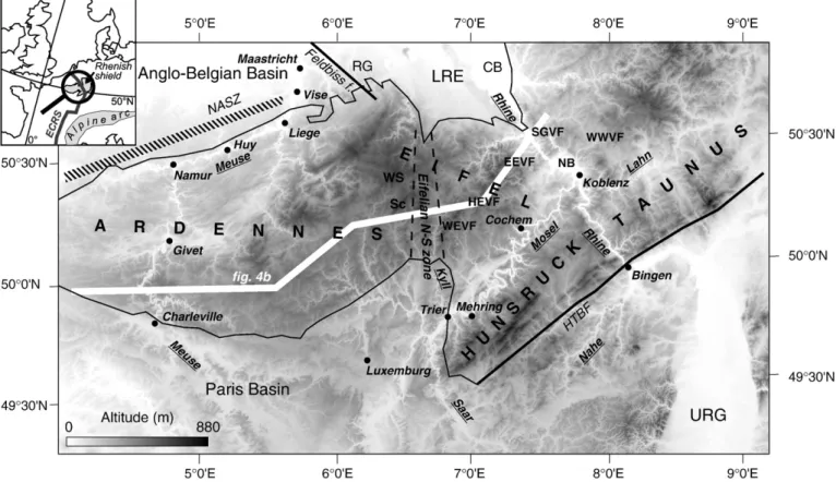
By contrast, the deep incision of the valleys in the massif bears witness to a Quaternary acceleration of the uplift. Fluvial terrace studies suggest that the uplift rate increased a first time at the Pliocene– Pleistocene transition and again towards the beginning of the middle Pleistocene to reach maximum values of ~0.5 mm/yr in NE Ardennes and Eifel between 730 and 400 ka before coming back to tectonic quiescence in recent times (Van den Berg, 1996; van Balen et al., 2000). As a consequence of this two-step increase in incision rate, a typical valley cross-section in the RS opposes a narrow steep-sided young valley nested into a broader older valley with gently sloping valleysides carved into the Tertiary paleotopography (Fig. 2). Dated ~0.73 Ma (van Balen et al., 2000; Boenigk and Frechen, 2006), the lower level of the extended Fig. 1. SRTM digital terrain model of the western Rhenish shield and the Ardennes, locating the main regions and features mentioned in the text. WEVF: West Eifel volcanicfield. HEVF: High Eifel volcanicfield. EEVF: East Eifel volcanic field. SGVF: Siebengebirge volcanic field. WWVF: Westerwald volcanic field. NB: Neuwied basin. WS: Weisserstein. Sc: Schneifel. LRE: Lower Rhine Embayment. RG: Roer graben. CB: Cologne block. URG: Upper Rhine graben. HTBF: Hunsrück–Taunus border fault. NASZ: North-Artois shear zone. ECRS: European Cenozoic rift system.
Fig. 2. Schematic cross-section of the Rhine valley with its terrace staircase (hatched) carved in the Rhenish shield. Most rivers of some importanceflowing down or across the massif display a similar profile with the successively developed Pliocene (I), broad early Pleistocene (II) and narrow middle Pleistocene (III) valleys. YMT: Younger Main Terrace.
Main Terrace complex clearly separates the two units and marks the beginning of the middle Pleistocene incision episode.
The present-day deformation and elevations of well reconstructed Tertiary planation surfaces demonstrate that the most elevated parts of the RS underwent an overall rock uplift of up to 400–450 m since the Oligocene.
The recent uplift of the RS occurred within a regional stressfield of NW Europe that is primarily determined by the Africa–Eurasia collision and the consequent Alpine push, and the mid-Atlantic ridge push. Since the end of the Miocene, this stressfield is characterized by a fan-shaped distribution of SHmaxalong the northern border of the Alpine arc, giving way to a more consistent N145°E ± 26° direction of compression further away from the chain (Bergerat, 1987; Müller et al., 1992). Currently, this finds expression in earthquake focal mechanisms showing exclusive normal faulting in the NW-trending LRE and mainly left-lateral transpressive motion in the NNE-trending URG (Pavoni et al., 1992).
The volcanic activity in and around the RS is probably in some way related to its uplift. While several volcanic centres (Vogelsberg, lower Hessian depression) developed chiefly during the middle Miocene in association with rifting east of the massif (Bogaard and Wörner, 2003), the volcanicfields of the uplifted area (Westerwald, Siebenge-birge and Eifel—Fig. 1) were active at various epochs throughout the Cenozoic. The main activity in the Westerwald and Siebengebirge has been dated between 30 and 20 Ma, with later phases in the SW Westerwald at 5–6 and 0.8–0.4 Ma (Haase et al., 2004; Schmincke, 2007). In the Eifel,Fekiacova et al. (2007)identified two main periods of volcanic activity during the Eocene in the High Eifel, at 44–39 and 37–35 Ma. The Quaternary West Eifel and East Eifel volcanic fields (Fig. 1, respectively, WEVF and EEVF) are located on both sides of the High Eifel area and show a similar migration of activity from (N)W to (S)E with time (Schmincke, 2007). In the WEVF, the activity started after 0.7 Ma, peaked between 0.6 and 0.45 Ma, then slowed down and resumed only after 0.1 Ma. In the EEVF, it started around 0.46 Ma in the west, migrated eastwards at 0.22 Ma to give rise, after a period of minor activity from 0.19 Ma onwards, to the major Laacher See erup-tion at 12.9 ka.
3. Existing RS uplift maps 3.1. Underlying assumptions
River incision data are often used to infer the amount of uplift of intraplate areas undergoing compressional stresses (Bonnet et al., 1998; Meyer and Stets, 1998, 2007; Peters and Van Balen, 2007). However, two important assumptions underlie this approach. Firstly, for large rivers originating from outside, and cutting across a localized uplifted area, it is presumed that bedrock incision is able to balance rock uplift, this being supposedly verified by the preservation of equilibrated river profiles, and therefore that the depth of incision reflects exactly the amount of uplift. This should be true at least in the long term, after recovery of the time lag between uplift and the resulting incision (Kiden et al., 1998). For smaller streams whose source lies in the uplifted area, their local incision is primarily controlled by the distance to the base level, so that their incision curve is not directly indicative of the amount of regional uplift, not to speak of tilting. To overcome the difficulty,Meyer & Stets (1998)in the RS, followed by van Balen et al. (2000)in their study of the Meuse catchment in the Ardennes, stated that the amount of uplift deduced from the incision of the major rivers transecting the massif can be propagated unchanged up-valley in the tributaries as long as the reconstructed long profiles of the reference terrace level remain undisturbed. Furthermore, they systematically interpreted all dis-continuities they identified in the terrace profiles of the tributaries as tectonically-driven departures from an idealized equilibrium profile extrapolated from the regular profile preserved in assumed undis-turbed reaches of the valley.
The second important assumption made to establish a univocal link between tectonic uplift and river incision is that other triggers of incision, like climatic changes, sea-level lowering or stream piracy, are comparatively negligible or absent. Although the last glacial fall in sea level caused some incision in the lowest reaches of the river Meuse in the Netherlands (Törnqvist, 1998), it is long recognized that this influence was rapidly limited inland (Bridgland, 2000). In the Meuse catchment, it did not reach Maastricht (Veldkamp and van den Berg, 1993), and a fortiori did not affect river incision within the RS and the Ardennes. As for the climatic factor, the published maps of the RS uplift (van Balen et al., 2000; Meyer and Stets, 2002, 2007) incor-porate only the fact that the 100 kyr glacial–interglacial cycles put rhythm in the incision and created the terrace staircases but they overlook any possible link between climate change and the onset of uplift.
Beyond these assumptions regarding the relation between rock uplift and river incision, two further hypotheses underlay the com-putation of the RS uplift. Firstly, the recently published uplift maps were based on the hypothesis that the gradients of the reference terrace (YMT) and the modernfloodplain were similar, though this is not universally accepted (Kremer, 1954; Löhnertz, 2003). Secondly, in the absence of sufficient dating and reliable petrographical or mineralogical characterization, it was presumed that the used geomorphological marker was unequivocally identified throughout the massif and was of the same age everywhere.
3.2. Terrace data
The Quaternary terrace staircases of the Meuse and Rhine rivers and of their tributaries have been extensively studied since a century. In the Meuse valley,Van den Berg (1996)mapped a sequence of 31 stepped terrace levels in the Maastricht area, ~20 km to the north of the Ardennes' margin. In the region of Liège-Visé, between Maastricht and the Ardennes, Juvigné and Renard (1992) still identified 23 superposed levels, several of which are related to local meandering of the river.Pissart et al. (1997)drew 12 terrace levels in the massif itself and up to 16 in the part of the Meuse catchment pertaining to the Paris basin. Numerousfield studies identified also 10–12 levels along the main (sub)tributaries of the Meuse in the Ardennes massif, often reducing to 6–7 in their upstream reaches (e.g.,Cornet, 1995).
In the Rhine valley,Boenigk and Frechen (2006)described 16 suc-cessive terrace levels. In the lower Middle Rhine area, they distinguished a higher complex of lower Pleistocene terraces followed by 11 younger levels (Table 1), whileBibus (1983a)recognized 11 Quaternary levels in all. In the upper Middle Rhine area,Peters and Van Balen (2007)
presented also aflight of 11 Quaternary terraces (Table 1). In the Mosel valley, where tectonic deformations seem to have strongly disturbed some terrace levels, 12 of them were identified byBibus (1983b)in the lowest reaches of the valley, downstream of Cochem, instead of 9 by
Negendank (1983)between Trier and Koblenz. Although the terrace correlations are still disputed in the lower Mosel, many authors agree now to locate a main tectonic discontinuity just downstream of Cochem. Upstream of Trier,Cordier et al. (2006)recently drew and dated 8 terrace levels located less than 90 m above the modernfloodplain, correspond-ing to the period since OIS 16. In the Lahn valley,Andres and Sewering (1983)mapped 12 superposed levels, while numerous studies of the smaller valleys of the RS generally identified at least 6 levels (e.g.,Zepp, 1933; Zenses, 1978).
Whatever the number of terrace levels is, a characteristic feature of all valleys throughout the massif is their typical cross-section, with a narrow valley deeply and abruptly incised into a broader, older “plateau valley”, reflecting the mid-Pleistocene increase in incision rate (Fig. 2). The extended terraces of the plateau valley are generally grouped into a Main Terrace complex, and the levels of the incised valley are referred to as middle and lower terraces. The younger of the two most extended levels of the Main Terrace complex (YMT) thus
represents a remarkable geomorphological marker located at the upper edge of the incised valleys. It is readily recognized in thefield and has been used as a reference level for the measurements of the recent river incision in the RS (Ploschenz, 1994; Hoffmann, 1996). As such, it can be propagated upstream and mapped even in relatively small tributaries (down to ~20 km in length), although with growing uncertainty, by morphological continuity and geometric correlation. It thus provides information over incision in the whole RS in a much denser way than observations limited to the few lines of the major rivers crossing the massif. Based on magnetostratigraphic evidence at Maastricht, Meuse valley (Van den Berg, 1996; van Balen et al., 2000), and Kärlich, Rhine valley (Boenigk and Frechen, 1998, 2006), the YMT level is dated ~0.73 Ma and ascribed to OIS 18 (Table1), This age is further confirmed by40
K/39Ar and40Ar/39Ar dating of tephra markers in various sections of the middle Rhine valley (Fuhrmann, 1983; Bogaard and Schmincke, 1990). Although limited to the lower and middle terraces, the chronostratigraphy derived from luminescence dating of the Mosel terraces (Cordier et al., 2006) leads also to place the YMT in the OIS 18.
The relative elevation (or elevation above the modernfloodplain) of the YMT is highly variable in the RS. Maximum values of 180–200 m are observed in the Cochem area of the lower Mosel valley (Negendank, 1978; Hoffmann, 1996; Meyer and Stets, 1998) (Fig. 1). From there the post-YMT incision of the Mosel progressively decreases upstream, that is southwestwards, but it is still ~150 m deep in the Trier area, where the river leaves the Luxemburg Embayment to enter the actual RS. Over its crossing of the RS, the Rhine valley displays slightly lower values of post-YMT incision, comprised between 120 and 150 m. To the northwest, its incision diminishes rapidly as it exits the RS, being only ~60 m in Cologne, within the uplifted Cologne block of the LRE. By contrast, the post-YMT incision of the Meuse valley into the Ardennes is much more limited, amounting to ~65 m at the northern margin of the massif in Liège, ~35 m in Namur, and only ~15 m at its entrance in the massif at Charleville. As a rule, the post-YMT incision of the intra-massif tributaries decreases towards the headwaters from the values recorded at their confluence with the main rivers. Besides incision, deformation of the YMT long profiles inside the massif is also indicative of recent uplift and tilting. This is notably the case of the slight counterslope displayed by the Meuse YMT profile between Namur and Liège, the horizontality of the Mosel YMT between Trier and Cochem and that of the Rhine YMT in its upper middle valley, between Bingen and Koblenz (Fig. 1).
3.3. Uplift of the Rhenish shield: the common view
During the last two decades, the terrace staircases of most rivers of the RS were revisited in numerous local studies carried out by researchers of the Geological Institute of the Bonn University. Based on a careful compilation of the literature plus newfield work and mapping, they put emphasis on the reconstruction of YMT profiles. Regional syntheses of the post-YMT river incision, from which the post-0.73 Ma (rather than the generally stated 0.8 Ma) uplift of the massif was inferred, can be found inPloschenz (1994)for the south-eastern RS, Hoffmann (1996) for the south-western RS and Zapp (2003)for the north-eastern RS. A synthesis over the whole massif (Fig. 3a) was presented in several papers byMeyer and Stets (1998,
2002, 2007) and the latter's work was extended and completed
towards the Ardennes (Fig. 3b) byvan Balen et al. (2000), who used the same methodology.
These recently published maps agree to locate two spots of maximum post-0.73 Ma uplift on both sides of the lower Mosel valley, respectively in the S-central Eifel and the NE Hunsrück (Fig. 3). The maximum uplift amounts to almost 300 m in the Eifel and ~250 m in the Hunsrück (Hoffmann, 1996; Meyer and Stets, 2007) but it should be noted that in both cases, it was inferred from the analysis of the YMT of intra-massif tributaries. Surprisingly, the intervening reach of the Mosel valley is much less uplifted (~180–200 m), while the YMT of the Mosel shows its greatest deformation more southwestwards. In the northwest of the massif, some disagreement exists between Meyer and Stets (2002, 2007), who identified a vast area of high uplift (>200 m) extending over the whole NW Eifel and NE Ardennes, andvan Balen et al. (2000), who described a sharp north- and westward decrease of the uplift amount, down to values <100 m, located in the eastern confines of the Ardennian catchment of the Meuse, west of the Weisserstein and Schneifel highs (Fig. 1). According to the latter authors, most of the central Ardennes was uplifted by less than 50 m, the eastern end of the massif having hardly moved (<15 m) since the time of the YMT. East of the Rhine valley, the YMT data are sparser and although the Taunus area displays the highest altitudes of the RS,Meyer and Stets (2007)suggested that most of the eastern half of the RS went up by only ~50 m or less. However, from the study of the Lahn terraces,Ploschenz (1994)concluded that the WSW-trending Lahn valley represents an elongated area of locally higher, up to ~100 m post-YMT uplift. Finally, the southern border of the RS is characterized by a gradual decrease in uplift, from 100–150 m in the central Hunsrück to less than 50 m in the Saar–Nahe basin.
Though the view of the post-YMT uplift of the RS and Ardennes provided by the smoothed synthetic maps ofMeyer and Stets (e.g., 2007) andvan Balen et al. (2000)is fairly simple, it is also instructive to go back to the original subregional maps, which depict in fact much more complicated uplift patterns with many marked uplift gradients and small faulted blocks in various directions, inferred from the incision data (e.g.,Hoffmann, 1996, p. 131).
4. Additional geomorphological data 4.1. Deformation of Tertiary planation surfaces
The tectonic uplift responsible for river incision and for the development of Quaternary terraces has obviously affected older landscape features too. However, such older morphologies may have suffered also pre-Quaternary deformation. Therefore, only in case of a clearly different amount and/or spatial pattern of deformation might their analysis compel to reconsider the conclusions drawn from the study of Quaternary terraces.
The main element of the Tertiary landscape of the RS is the planation surface, whose original large-scale evenness and quasi-horizontality make it an ideal marker of subsequent deformation. The associated deep weathering products demonstrate that such surfaces were produced by etchplanation under tropical conditions and at low altitudes (Thomas,
Table 1
Comparison of the most recently proposed models for the Meuse and Rhine terrace stratigraphy showing that most authors agree on the position of the local equivalents (in underlined bold characters) of the YMT.
Ma OIS Meuse at Maastricht Middle Rhine
van Balen et al. (2000)
Westaway (2002) Boenigk and Frechen (2006)
Peters and Van Balen (2007) 0.02 2 Mechelen Mechelen LT tR10–tR11 0.06 4 0.13 6 Eisden–Lankl. Eisden–Lankl LMT2 tR9 0.25 8 Caberg3 Caberg3 LMT1 tR8 0.33 10 Caberg 2-1 (?) Caberg2 MMT2 0.42 12 Rothem2 Caberg1 MMT1
0.55 14 Rothem1 Rothem1 UMT tR7
0.63 16 S’Gravenvoeren S’Gravenvoeren UT4 tR6 0.73 18 Pietersb.3-2-1 (?) St Pietersb.3 UT2/3 tR5
0.8 20 St Pietersb.2 UT1 tR4 0.88 22 St Geertruid3 St Pietersb.1 0.92 24 0.96 26 St Geertruid2 (?) 1 28 St Geertruid3 1.04 30 1.09 32 St Geertruid1 St Geertruid2 1.12 34 1.2 36 Valkenburg2 (?) 1.25 38 1.29 40 Valkenburg1 (?) St Geertruid1 tR3
1994). The present altitudes, in particular of stepped surfaces, are thus also roughly indicative of the chronology of uplift.
The Tertiary landscape of the RS and the Ardennes is composed of two sets of stepped surfaces (e.g.,Hüser, 1973; Quitzow, 1982). The highest, oldest one generally comprises two superposed surfaces of pre-oligocene age, often called R1 and R2 in the RS, in reference to the pioneering works ofPhilippson (1903)andStickel (1927). Below are
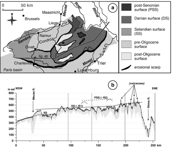
developed the often less extended“trough surfaces” of the second set. Within the Ardennes, whose margins still preserve sediments deposited by several Paleogene transgressions,firmer age constraints allowed Demoulin (1995) to distinguish 4 stepped pre-oligocene surfaces and a younger level of more local planation. The literature compilation of Hüser (1973)underlined the great diversity of the concepts used by various authors to decipher the Tertiary landscapes Fig. 3. Recently published maps describing the post-YMT uplift of theArdennes–Rhenish shield. a. Meyer and Stets (2002). b.van Balen et al. (2000).
of diverse parts of the RS, but it also highlighted a fair uniformity in the altitudes of the identified surfaces throughout the massif. In his comprehensive analysis of the planation surfaces of Ardennes, Eifel and surroundings, Demoulin (2003, 2006) mapped the following surfaces (Fig. 4a):
• remains of a pre-cretaceous surface at altitudes above 620 m in the eastern and NE Ardennes and the western Eifel
• an extended Danian surface corresponding to the R1 surface of
Stickel (1927)and the“surface supérieure” ofMacar (1938). This surface is slightly domed, with altitudes of 560–580 m in the centre, reaching ~600 m in the central Eifel and decreasing to ~ 520 m in southern Ardennes and NE Eifel
• a Selandian surface developed in the western Ardennes at altitudes lower than 450 m. This surface is slightly tilted westward and does not exceed 400 m to the west of the Meuse valley
• “pre-oligocene” (but post-lutetian) surfaces encompassing the northern part of the massif (Condroz) and, beyond its southern limit, the ridge tops of the northern Paris basin. In the Condroz, the surface is tilted northward, rising from 250 m altitude south of the Meuse valley to ~400 m at the foot of the higher surface in the central Ardennes. In the northern Paris basin, the pre-oligocene surface is more or less horizontal at 380–400 m altitude and is prolonged at similar altitudes in the Eifel by the“Mosel trough” • more local planation “intramountain” basins nested mainly in the
Danian surface of the central Ardennes and developed in possible relation with an upper Oligocene–Miocene base level represented by the top of the Oligocene sand cover in the Condroz.
The geomorphological reconstruction of these planation surfaces is supported by the geometrical link with their buried equivalents in the adjacent basins and the careful analysis of the correlative residual deposits (Demoulin, 2006). It was also recently confirmed by radiometric and paleomagnetic dating of the weathering mantle veiling the Danian and Selandian surfaces (Théveniaut, 2003; Yans, 2003). The morphological scarps separating the stepped surfaces may thus safely be defined as erosional rather than tectonic scarps, and the post-oligocene deformation of the surfaces only amounts to weak marginal tilting, chiefly in the N–S direction. The two surfaces most elongated in the E–W direction, that is, the Danian surface and the pre-oligocene surface of the northern Paris basin and the Mosel area, show almost no sign of E–W deformation, at best a faint westward tilt (<1‰), and the Selandian surface alone displays a slightly higher tilt (1–2‰) in the same direction in the westernmost part of the Ardennes (Fig. 4b). However, it seems that the Eifelian part of the Danian surface is separated from its Ardennian prolongation by a gentle, ~ 25-m-high, north-trending scarp (Fig. 4b). This minor feature is not observed in thefield, but it is rather deduced from the difference in height of the surface in the two regions. As it extends along the early Mesozoic structure of the Eifelian N–S zone, we cannot exclude a possible tectonic origin, although of undetermined age.
4.2. Captures of the Meuse basin and the Meuse incision
As river incision since the YMT is used as the marker of the RS uplift, it is of utmost importance to identify every non tectonic factor of incision and to remove its effect, especially if it is spatially variable. Among these factors, stream piracy may induce notable changes in the
Fig. 4. The Tertiary planation surfaces of the Western Rhenish shield and the Ardennes. a. Map of the surfaces in the Ardennes and the Eifel. b. A WSW–ENE topographic section (see location onFigs. 1and 4a) along the axis of the massif shows almost undeformed planation surfaces. The extended Danian surface is mainly characterized by a slight overall westward tilt and displays only a gently sloping 25-m-high scarp possibly located across the Eifelian N–S zone.
stream power and incision capability of individual rivers, interfering regionally or locally with the overall incision response to tectonic uplift.
Based on detailed geomorphological and mineralogical studies,
Pissart et al. (1997)reconstructed the profiles of the Meuse terraces from Toul, in the Paris basin, to Maastricht, north of the Ardennes (Fig. 5b) and dated several captures that severely beheaded the Meuse basin since 1 Ma. They notably concluded that the Meuse lost a considerable part of its catchment upstream of the Ardennes when the upper Aisne, which previouslyflowed toward, and developed wide meanders into the present Bar valley, was captured at the benefit of the Seine basin, most probably around 0.9 Ma (Fig. 5a). At this time, the upper Marne and some of its tributaries (Ornain, Saulx) still pertained to the upper Aisne basin, so that the Meuse catchment abruptly lost ~ 6760 km2.
Dated ~ 0.25 Ma (Huxtable and Aitken, 1985; Losson and Quinif, 2001), the capture of the upper Mosel at Toul reduced the Meuse
catchment by a further ~3400 km2. This occurred at the benefit of the Rhine–Mosel system, so that the post-0.25 Ma incision of the Mosel amounted to ~ 30 m whereas the Lorraine Meuse strongly aggraded in the same time, by up to 20 m just downstream of the former Mosel confluence (Harmand et al., 1995; Cordier et al., 2006). Note by the way that these observations indicate that the Meuse suffered a heavier loss of stream power than of sediment load from the capture. Finally, the Aire river, which had continued toflow into the Bar valley after the capture of the upper Aisne, was also diverted toward the Seine basin at an unknown time after 0.9 Ma (Pissart et al., 1997).
Altogether, the captures suffered by the Meuse basin upstream of the Ardennes in the last 1 Ma took ~11000 km2off it. Compared to the remaining ~7500 km2of the present Lorraine Meuse catchment, this represents a loss of ~60% of the original early Pleistocene basin of the river, leading to the current disproportion between the Meuse and Mosel at their entrance in the massif: while the drainage basin of the Meuse at Charleville attains a bare 7500 km2, that of the Mosel at
Fig. 5. Evolution of the Meuse since ~ 1 Ma, in planform and in longitudinal section (modified afterPissart et al., 1997). a. Stream piracy in the upper catchment of the Meuse in the northern Paris basin. The bold black line delimits the Meuse catchment, from which the hatched areas were subtracted by river captures at the times given in Ma in thefigure. The numbers in italic along the Meuse, the Mosel and the Rhine give the amount of incision or aggradation (negative values) since the capture of the upper Mosel (~0.25 Ma). b. Terrace profiles of the Ardennian Meuse. The incision values in the early Pleistocene versus middle Pleistocene to Holocene, i.e., before and after the YMT, are of 70/15 and 45/65 m respectively near Charleville (I) and Liege (II).
Konz, just before the Saar confluence, amounts to 18000 km2(not to speak of the ~100000 km2of the Rhine basin at Bingen). This dif-ference is still reflected in the current gradients of the rivers in their crossing of the massif, respectively 0.43‰ for the Meuse and 0.25‰ for the Mosel and the Rhine. Based on the approximate relation Qb∝A0.8 (with Qb= bankfull discharge and A = drainage area) (e.g.,Bravard
and Petit, 1997), one calculates that the present stream powerω of the Meuse entering the massif is ~ 22% and 85% of those respectively of the Rhine and the Mosel, yielding fairly similar values of unit stream powerωa=ω/w (with w = channel width) for the three rivers. In other words, this means that, given its reduced drainage area, the Meuse has to maintain a steeper gradient in order to uphold a similar level of hydrological equilibrium as the Rhine and the Mosel. Assuming that the original (pre-capture) gradient of the Meuse was also ~0.25‰, its steeper present gradient over the whole crossing of the Ardennes involves a deficit of post-capture incision of ~40 m in the Givet–Charleville area, whatever the uplift amounted to.
4.3. River incision outside the Rhenish shield
Another potential factor of river incision that was neglected in the published maps of the tectonic uplift of the RS is climate change. However, more and more studies offluvial terraces in western Europe, supported by a fast growing number of sediment dating, recently showed that river incision in the last million years or so was a wide-spread phenomenon, not restricted to areas of tectonic uplift (e.g.,
Bridgland, 2000; Maddy et al., 2001; Antoine et al., 2007). Most studied rivers, including those draining lowland areas (e.g., Somme, Seine, Scheldt, Thames), developed terrace staircases corresponding to ~ 50 m or more of incision since ~0.8 Ma, and worldwide obser-vations carried out as part of IGCP 449 seem to confirm this picture at the global scale (Bridgland et al., 2007; Bridgland and Westaway, 2008). The rock uplift inferred from this large set of incision data has been tentatively interpreted in terms of isostatic response to the enhanced "climatic denudation" occurring since the mid-Pleistocene climatic deterioration resulting from the emergence of a predominant 100 kyr glacial cycle (Bridgland, 2000). Although others reject the proposed interpretation involving lower crustal flow (Ziegler and Dèzes, 2007), the fact remains that an ubiquitous component of ~ 50 m post-YMT incision seems to result from a global, probably climate-related cause distinct from regional tectonics.
5. Discussion
We will now rely on the geomorphological data presented above to discuss the validity of the assumptions underlying the uplift-incision relation that served to establish the existing maps of the RS uplift. It will rapidly appear that some of these assumptions are basically flawed or inconsistent with the data and that the whole picture needs to be reassessed within a broader context, notably (re)considering the following issues.
5.1. Incision in the tributaries
The area of highest uplift (>250 m) located in the southern Eifel (Hoffmann, 1996; Meyer and Stets, 2002, 2007) was derived from the interpretation of YMT data of Mosel tributaries in which the actual post-YMT incision does not exceed 190 m at the confluence and decreases rapidly upstream. Such high calculated uplift values result from the assumption that every vertical discontinuity in the recon-structed profiles of the YMT of tributaries has to be ascribed to a tectonic motion (Fig. 6a). However, the comparison of the disconti-nuities affecting the YMT profiles of the left-side tributaries of the Mosel shows a complicated and tectonically inconsistent pattern of deformations that vary spatially not only in amount but especially in transverse development, ranging from a fairly clear-cut fault-line-like
step across the Alf to a 25-km-wide flexured area across the Kyll (Fig. 6b).
An alternative, more probable interpretation is that most of the discontinuities in the YMT profiles of the tributaries correspond to knickpoints created because of the pre-YMT Mosel incision and stopped in their upstream retreat at the time of abandonment of the YMTfloodplains. Indeed, taking the Kyll as a representative example (Fig. 6a), its YMT profile displays two fairly equilibrated reaches separated by a knickpoint. Although knickpoints of lithological origin may also be found in the Eifel area like, e.g., that in the present long profile of the Alf across a basaltic lava flow, the knickpoint in the Kyll YMT cannot be ascribed to any lithological heterogeneity, and this is also true for the majority of the other observed YMT discontinuities. If one prolongs the higher equilibrium reach downstream, it appears perfectly inscribed in the Mio–Pliocene morphology of the Mosel trough. Then, when the Mosel entered afirst phase of incision leading to the development of its early Pleistocene broad valley, it induced a wave of regressive erosion in the Kyll valley and the retreating knickpoint left behind the lower equilibrium reach observed in the present YMT profile. Of course, the rate of knickpoint retreat decreased when approaching the headwaters, more especially as the fine material delivered at that time by the kaolinic weathering mantle veiling the Tertiary surfaces of the Eifel was rather inefficient as a bedload to carve into the underlying Paleozoic hard rocks. In the next phase of post-YMT incision however, the influence of the climatic degradation was probably responsible for a renewed incision affecting immediately the rivers over their whole length, so that the YMT of the Kyll retained its irregular profile. The knickpoint marking the long profile of the modern Kyll suggests that afterwards, the tectonic factor prevailed again, launching a new wave of regressive incision in the tributaries. Note also that the knickpoint of the modern Kyll is located downstream of the corresponding YMT knickpoint, whereas it should be situated upstream if the YMT discontinuity had betrayed a recent tectonic deformation.
To sum up, this interpretation of the YMT profile discontinuities is much more realistic than a tectonic one because (1) the creation of knickpoints in the tributaries was the natural response to their base level lowering when the main rivers (Rhine, Mosel, Meuse) started to incise in the early Pleistocene, (2) the expected variable rate of knickpoint retreat and decay in rivers of different power is more consistent with the varying shape and position of the observed profile discontinuities and (3) similar profile irregularities are still often observed in the modern long profiles of the same rivers as a con-sequence of the post-YMT incision of the trunk streams, which low-ered anew their base level.
5.2. E–W uplift gradient
A remarkable characteristic of the uplift map ofvan Balen et al. (2000)is the sharp E–W uplift gradient they mapped across the eastern Ardennes (ΔU=100 m within 25 km). This was obviously a central feature in the attempt ofGarcia-Castellanos et al. (2000)to produce a model of the RS uplift thatfitted the observed uplift pattern, and it led them to the conclusion that the best model involved localized lithospheric weakening in association with a buoyant hot body beneath SE Eifel.
However, this sharp gradient is basically a result of the very different post-YMT incision values measured in the Meuse valley and the Rhine– Mosel system, and of the way in which incision/uplift values read along the main rivers were propagated upstream within the tributaries, according to the method proposed byMeyer and Stets (1998). As such, an incision gradient surely should not be converted into an uplift gradient so straightforward, without taking into account the decisive influence on incision of the respective basin histories. The numerous captures suffered by the Meuse in its upper catchment during the last 1 Ma dramatically reduced its stream power, which was restored only
through a reduced incision in response to the massif uplift, and con-sequently a steepening of the river slope. As calculated above from the river slope data, the resulting lack of incision would amount to ~40 m, that is, almost half of the reported localized gradient of uplift. Moreover, the loss of the upper Mosel by the Meuse at ~0.25 Ma occurred at the benefit of the Rhine–Mosel system, thus further enhancing the contrast in incision capacity between both basins. In fact, given the limited size of its present basin upstream of the Ardennes, the Meuse seems no longer to be able to maintain an equilibrium profile only by incision in case of a vertical motion of the massif (as this is most likely also the case of the Lahn River in the eastern RS). Indeed, not only was the incision of the Meuse at its entrance in the Ardennes at Charleville very weak (15 m post-YMT incision, from which hardly 5 m after the capture of the upper Mosel), but the river alsofilled its valley by up to 20-m-thick deposits in
the northern Paris basin since the loss of the upper Mosel (Harmand et al., 1995) (Fig. 5a).
Though a part of the difference in incision between the Meuse and Rhine/Mosel basins is explained by the catchment history, the cor-rected data still point to a significant E–W uplift gradient, amounting to ~140 m between the SE Eifel and the western Ardennes. However, the only usable incision values, that is, those of the main rivers, cannot constrain the details of the uplift shape and one has to invoke other geomorphological markers in order to distinguish between a smooth westward tilt and a more localized uplift gradient.
In principle, a sharp gradient should be visible in the general topography of the massif, and in particular in the E–W profile of the extended planation surfaces. Being older, the Tertiary planation sur-faces provide an excess estimate of the Quaternary deformation of the Fig. 6. YMT profile anomalies in the Eifelian tributaries of the Mosel. a. YMT profile of the Kyll, modified afterHoffmann, 1996. The YMT of the Kyll is geometrically correlated with that of the Mosel. Despite its irregular long profile, it is also unmistakably distinguished in the field by the unusually large extent of its remnants and its position at the hinge between the gentle slopes of the broad higher valley and the steep slopes of the nested V-shaped valley. The thick black line represents the long profile of the present floodplain, the dashed line is for the YMT reconstructed profile, and the dotted line for the assumed Mio–Pliocene profile of the river. The thick grey line corresponds to the average interfluve topography made of Tertiary planation surfaces (from top, R2, R1 and the Mosel trough) separated by erosional scarps. The difference between an idealized YMT profile (thin grey dotted line), prolonged from the upper reach downstream, and the actual profile was interpreted byHoffmann (1996) andMeyer and Stets (1998, 2002, 2007) as resulting from a differenceΔU in post-YMT uplift between points a and b. Instead, we ascribe the YMT profile irregularity of the Kyll to knickpoint retreat (KR) induced by the early Pleistocene incision that led to the formation of the Mosel YMT. b. Map locating the discontinuities in the YMT profiles of the Eifelian tributaries of the Mosel. The numbers denote the height of the irregularities in metres and the light grey band locates the major morphological scarp between the R1 surface and the Mosel trough. There is poor consistency in value as well as in extent between the irregularities observed in the parallel tributaries, which are no more clearly linked to the position of the scarp.
massif. Yet, the Danian surface, which extends over the central Eifel and Ardennes, displays only a very weak (~ 25 m) localized deformation of unknown age across the Eifelian N–S zone, as stated above, and it presents rather a continuous westward tilt <1‰ (Fig. 4b). This tilt value is remarkably similar to the WSW-ward tilt of 0.6‰ indicated by the longitudinal slope of the YMT profile of the Meuse reach between Namur and Liège, along the northern rim of the Ardennes (Pissart, 1974), and of the Mosel between Trier and Cochem (Negendank, 1978). It causes a smooth uplift gradient of 120 m over the ~ 200 km separating the SE Eifel from the Charleville area in western Ardennes, thus accounting for the greatest part of the cor-rected gradient.
5.3. A new map for the post-0.73 Ma tectonic uplift of the western Rhenish shield and the Ardennes
As a result of the above discussion, the main modifications brought to the previous maps of the RS uplift concern (1) the maximum post-0.73 Ma uplift in the SE Eifel area, which cannot be reliably deduced from observations in the tributaries of the Mosel and is now estimated at ~190 m, corresponding to the maximum post-YMT incision in the lower Mosel itself, and (2) the E–W profile of the uplift west of this maximum, which is shown to be almost straight and slightly tilted, in agreement with the observed tilt of the Tertiary planation surfaces and the YMT profiles of the main rivers, rather than characterized by a marked uplift gradient in the eastern Ardennes. Despite the weak incision of the Meuse, this still gives ~ 50–60 m of post-YMT upheaval in western Ardennes, with a corrected profile typical of an epeirogenic domed uplift. In addition, the new map removes the unlikely com-plicated pattern of uplift proposed byMeyer and Stets (2002, 2007) across the Mosel valley downstream of Cochem.
Moreover, the ubiquitous river incision in western Europe since ~ 0.8 Ma, which amounts to a mean 50 m in non tectonic areas like, e.g., the western Paris basin, had most likely a supraregional cause (Bridgland and Westaway, 2008). Whatever the involved mechanism was, it is interesting to compare these 50 m of incision/uplift with the few denudation rates currently yielded by cosmogenic nuclide studies in the same area, which suggest the removal of a 40 to 60-m-thick rock slice in the last 1 Ma (Schaller et al., 2004) and lend consistency to the hypothesis of an isostatic response to (climatic?) denudation for this component of uplift. The amount of the RS uplift really pertaining to regional tectonics should thus be diminished accordingly, not exceeding 140 m in the SE Eifel and decreasing to about 0 at the western margin of the Ardennes (Fig. 7).
Therefore, although the uplift is centred on the SE Eifel, which is also the approximate centre of the RS as a whole, its extent broader than inferred from previous analyses of river terraces and its linear NE-trending shape devoid of sharp lateral gradient strongly suggest that it might be predominantly related to a regional cause, like litho-spheric folding of the Alpine foreland (Nikishin et al., 1997; Cloetingh et al., 2005, 2007) or lithospheric thinning beneath the RS (Ansorge et al., 1992; Prodehl et al., 1995), rather than to the more local influence of the Eifel finger-plume (Ritter et al., 2001). While the pattern of the western RS uplift poorly matches that of the thickness variations of the NW European lithosphere (Artemieva et al., 2006), it perfectlyfits in with the large-scale succession of alternating top-ographic troughs and bulges elongating to the north of— and parallel to— the Alpine front that, based on a comparison with Moho and basement top maps of Europe,Bourgeois et al. (2007)interpreted as the result of lithospheric folding. Recently, such a periodic topographic signature, characterized by a wavelength of 250–400 km, an am-plitude of 500–1500 m and an elongation perpendicular to SHmax, has been increasingly ascribed to the buckling of the continental litho-sphere in various intraplate areas (e.g., central Asia:Burov and Molnar, 1998; Spain: Cloetingh et al., 2002; Australia: Célérier et al., 2005; Sandiford and Quigley, in press), including the western European
platform (e.g., German basin:Marotta et al., 2000; Brittany:Bonnet et al., 2000). In this context,Bourgeois et al. (2007)suggested that the Eifel volcanism might then result from a passive upwelling of the asthenosphere at the intersection of a lithospheric anticline with the thinned lithosphere beneath the ECRIS.
5.4. S–N migration of an uplift wave?
But even the corrected map of the RS' post-0.73 Ma uplift leaves an intriguing issue unsolved. There is indeed a geomorphological con-tradiction between the location of the zone of maximum uplift across the lower course of the Mosel valley and the capability of this stream to have captured nevertheless the upper Mosel. Moreover, though the sinuosity of the river may be partly influenced by the schistosity of the basement, it seems that it is also related to the recent tectonic tilt, but in a way opposite to that theoretically expected. Upstream of the uplift maximum of the SE Eifel, that is, in the zone of decreased gradient between Mehring and Cochem (Fig. 1), the middle course of the Mosel has a high sinuosity of ~2.1 (Hoffmann, 1996), whereas it diminishes abruptly to 1.25 in the lower Mosel downstream of Cochem, where the river descends the uplifted area towards the Neuwied basin (Fig. 7). However, especially for rivers meandering within afloodplain (Ouchi, 1985) but to some extent also for incising rivers trying to preserve their original slope, the sinuosity generally decreases in the valley reach“climbing” the uplift zone and increases down the opposite flank.
The link between the Mosel sinuosity and the location of the post-YMT uplift maximum remains therefore unclear. It can notwithstand-ingfind a satisfactory explanation if one assumes that the Quaternary uplift of the RS has been migrating from south to north, a hypothesis which is strongly supported by several other geomorphological observations. Indeed, over the post-0.73 Ma period, the maximum uplift has been recorded at the latitude of the central Eifel, and of Cochem in the Mosel valley. But, taking only the Holocene, there are hints of highest activity in the north of the massif. Most striking are the ungraded modern longitudinal profiles of the rivers in NE Ardennes (Demoulin, 1998) and the high, up to 1.6 mm/yr uplift rates inferred from high precision levelling data in NW Eifel (Mälzer et al., 1983), though the latter received an alternative interpretation as an isostatic response to the unloading of the LRE by mining and water pumping (Klein et al., 1997). Furthermore, in the Cologne block of the LRE, the highest rate of incision seems to have been attained between the Rhine middle terraces MT5 and MT6 (Boenigk and Frechen, 2006), that is, around 0.2 Ma instead of ~ 0.7 Ma, just after the YMT aban-donment, in the middle Rhine valley.
Conversely, observations all along the southern margin of the RS suggest that it underwent a peak of uplift during the early Pleistocene, when the rest of the massif was still fairly stable. The 70-m-deep incision of the Meuse between the high terraces 8 and 5 ofPissart et al. (1997)in the Charleville–Givet area not only is much higher than the ~ 15 m of later, post-YMT incision in the same place but also greatly exceeds the contemporaneous T8–T5 incision of ~45 m in the river course north of the massif, between Huy and Liège. Likewise though at a lesser degree, the 75 m separation between the higher terrace and the YMT of the Mosel as reconstructed byNegendank (1978)at the entrance of the river in the massif, SW of Trier, are significantly higher than the 50–60 m measured in the Cochem area. Furthermore, the main period of tributary captures in the Lorraine catchment of the Meuse around 0.9 Ma probably was related to the same early uplift of the southern border of the Ardennes. A similar conclusion of a north-migrating wave of uplift has also been reached byPeters and Van Balen (2007)from terrace analysis in the northern URG.
According to this interpretation, and given the fairly homogeneous lithology of the area, the high sinuosity of the middle Mosel might have developed at the right place to counteract the increasing channel gradient on the downstream limb of an early Pleistocene uplift whose
axis was located near Trier. At this time, the Mosel was still a mixed-load river that meandered freely in its broad valley and its immediate response to uplift and slope change was through sinuosity change, before the post-YMT incision produced much more stable entrenched meanders. The northward migration of the uplift is further reflected in the temporal variations of the Mosel meandering reconstructed by
Hoffmann (1996), who showed that, whereas the sinuosity was
increasing especially in recent times in the lower Mosel, it attained a much earlier peak, around 0.7–0.55 Ma, in its middle course, near Trier.
The Quaternary migration of the RS uplift from south to north is more or less opposite to the observed displacement of the volcanic activity in the WEVF and EEVF, which occurred at the same time from NW to SE, suggesting that both phenomena might have no direct link with each other or, in other words, that the uplift is not primarily caused by the rise of the Eifelfinger-plume. Instead, in addition to the revisited shape of the uplift, elongating parallel to the Alpine chain, this propagation of an uplift wave across the Alpine foreland further confirms that the uplift mechanism has most likely to be searched in relation with a continental-scale process like lithospheric folding. 6. Conclusion
In conclusion, any new modelling study aimed at testing potential causes of the recent RS uplift and, more generally, any integrated research based on the coupling of deep earth and surface processes in the West-European platform will have to base on a revised maximum amount of 140 m of post-0.73 Ma tectonic uplift in the SE Eifel, implying a recent uplift rate of 0.2 mm/yr, and on a corrected profile that is typical of an epeirogenic domed uplift. A detailed study of the eastern RS is still needed to confirm that this dome is probably slightly asymmetric because of the presence of the Hessian branch of the ECRIS east of the massif. Unfortunately, the geomorphological analysis of this part of the RS will not benefit from the presence of major rivers. The Lahn is a comparably small river that enters the massif with a still limited catchment and it is unlikely that its incision capacity could keep pace with the uplift. Notwithstanding, the revised shape of the post-0.73 Ma uplift of the RS clearly points at lithospheric folding of
the Alpine foreland as the most probable cause of the uplift. Finally, the proposed northward migration of an uplift wave across the northern alpine foreland sheds a new light on the linkages between deep earth processes and their topographic effects, and it will deserve further dedicated research in the RS and other Variscan massifs to be fully confirmed.
Acknowledgments
We gratefully thank M. Quigley and M. Sandiford, whose mean-ingful comments contributed to the improvement of thefirst version of this paper.
References
Andres, W., Sewering, H., 1983. The lower Pleistocene terraces of the Lahn river between Dietz (Limburg basin) and Laurenburg (lower Lahn). In: Fuchs, K., von Gehlen, K., Mälzer, H., Murawski, H., Semmel, A. (Eds.), Plateau Uplift, the Rhenish Shield— a Case History. Springer, Berlin, pp. 93–97.
Ansorge, J., Blundell, D., Mueller, S., 1992. Europe's lithosphere— seismic structure. In: Blundell, D., Freeman, R., Mueller, S. (Eds.), A Continent Revealed. The European Geotraverse. Cambridge Univ. Press, pp. 33–69.
Antoine, P., Limondin Lozouet, N., Chaussé, C., Lautridou, J.P., Pastre, J.F., Auguste, P., Bahain, J.J., Falguères, C., Galehb, B., 2007. Pleistocenefluvial terraces from northern France (Seine, Yonne, Somme): synthesis, and new results from interglacial deposits. Quat. Sci. Rev. 26, 2701–2723.
Artemieva, I., Thybo, H., Kaban, M., 2006. Deep Europe today: geophysical synthesis of the upper mantle structure and lithospheric processes over 3,5 Ga. In: Gee, D., Stephenson, R. (Eds.), European Lithosphere Dynamics: Geological Society, London, Memoirs, vol. 32, pp. 11–42.
Bergerat, F., 1987. Stressfields in the European platform at the time of Africa–Eurasian collision. Tectonics 6, 99–132.
Bibus, E., 1983a. Distribution and dimension of young tectonics in the Neuwied basin and the lower Middle Rhine. In: Fuchs, K., von Gehlen, K., Mälzer, H., Murawski, H., Semmel, A. (Eds.), Plateau Uplift, the Rhenish Shield— a Case History. Springer, Berlin, pp. 55–61.
Bibus, E., 1983b. The tectonic position of the Lower Mosel block in relation to the Tertiary and Old Pleistocene sediments. In: Fuchs, K., von Gehlen, K., Mälzer, H., Murawski, H., Semmel, A. (Eds.), Plateau Uplift, the Rhenish Shield— A case history. Springer, Berlin, pp. 73–77.
Boenigk, W., Frechen, M., 1998. Zur Geologie der Deckschichten von Kärlich im Rheinland. Eiszeitalt. Ggw. 48, 38–49.
Boenigk, W., Frechen, M., 2006. The Pliocene and Quaternaryfluvial archives of the Rhine system. Quat. Sci. Rev. 25, 550–574.
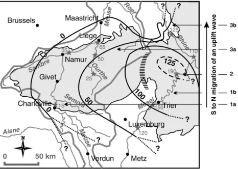
Fig. 7. Revised map of the post-0.73 Ma tectonic uplift of the western Rhenish shield and the Ardennes. The contour lines and black numbers give the estimated tectonic component of the uplift in metres. Add 50 m to these values to obtain the actual uplift amount, including the regional isostatic (?) component. The striped area locates a slight gradient in uplift between Eifel and Ardennes. Features indicating the northward migration of an uplift wave (see text): 1a. early versus middle Pleistocene vertical spacing between the Meuse terraces in the Charleville–Givet area.1b. position of the highly sinuous reach of the Mosel (see text for explanation). 2. maximum post-YMT incision. 3a. modern longitudinal profiles of the rivers in NE Ardennes. 3b. vertical spacing between the middle terraces of the Rhine in the Cologne block. The middle grey stars and numbers denote observed post-YMT river incision in metres. The thick grey lines delimit the Meuse and Rhine/Mosel basins.
Bogaard, P., Schmincke, H., 1990. Die Entwicklungsgeschichte des Mittelrheinraumes und die Eruptionsgeschichte des Osteifel-Vulkanfeldes. In: Schirmer, W. (Ed.), Rheingeschichte zwischen Mosel und Maas: DEUQUA-Führer, vol. 1, pp. 166–190. Bogaard, P., Wörner, G., 2003. Petrogenesis of basanitic to tholeiitic volcanic rocks from
the Miocene Vogelsberg, Central Germany. J. Petrol. 44, 569–602.
Bonnet, S., Guillocheau, F., Brun, J.P., 1998. Relative uplift measured using river incision: the case of the Armorican basement (France). C.R. Acad. Sci. 327, 245–251. Bonnet, S., Guillocheau, F., Brun, J.-P., Van den Driessche, J., 2000. Large-scale relief
development related to Quaternary tectonic uplift of a Proterozoic–Paleozoic basement: the Armorican Massif, NW France. J. Geophys. Res. 105/B, 19273–19288. Bourgeois, O., Ford, M., Diraison, M., Le Carlier de Veslud, C., Gerbault, M., Pik, R., Ruby, N., Bonnet, S., 2007. Separation of rifting and lithospheric folding signatures in the NW-Alpine foreland. Int. J. Earth Sci. 96, 1003–1031.
Bravard, J.P., Petit, F., 1997. Les cours d'eau. Dynamique du systèmefluvial. A. Colin, Paris. 222 pp. (in French).
Bridgland, D., 2000. River terrace systems in north-west Europe: an archive of environmental change, uplift, and early human occupation. Quat. Sci. Rev. 19, 1293–1303.
Bridgland, D., Westaway, R., 2008. Climatically controlled river terrace staircases: a worldwide Quaternary phenomenon. Geomorphology 98, 285–315.
Bridgland, D., Keen, D., Westaway, R., 2007. Global correlation of Late Cenozoicfluvial deposits: a synthesis of data from IGCP 449. Quat. Sci. Rev. 26, 2694–2700. Burov, E., Molnar, P., 1998. Gravity anomalies over the Ferghana Valley (central Asia)
and intracontinental deformation. J. Geophys. Res. 103/B, 18137–18152. Camelbeeck, T., Meghraoui, M., 1998. Geological and geophysical evidence for large
palaeoearthquakes with surface faulting in the Roer graben (northwestern Europe). Geophys. J. Int. 132, 347–362.
Célérier, J., Sandiford, M., Hansen, D., Quigley, M., 2005. Modes of active intraplate defor-mation, Flinders Ranges, Australia. Tectonics 24, TC6006.doi10.1029/2004&C001679. Cloetingh, S., Burov, E., Beekman, F., Andriessen, P., Garcia-Castellanos, D., De Vicente, G.,
Vegas, R., 2002. Lithospheric folding in Iberia. Tectonics 21, 1041.doi10.1029/ 2001TC901031.
Cloetingh, S., Ziegler, P., Beekman, F., Andriessen, P., Matenco, L., Bada, G., Garcia-Castellanos, D., Hardebol, N., Dezes, P., Sokoutis, D., 2005. Lithospheric memory, state of stress and rheology: neotectonic controls on Europe's intraplate continental topography. Quat. Sci. Rev. 24, 241–304.
Cloetingh, S., et al., 2007. TOPO-EUROPE: the geoscience of coupled deep Earth-surface processes. Glob. Planet. Change 58, 1–118.
Cordier, S., Harmand, D., Frechen, M., Beiner, M., 2006. Fluvial system response to Middle and Upper Pleistocene climate change in the Meurthe and Moselle valleys (Eastern Paris Basin and Rhenish Massif). Quat. Sci. Rev. 25, 1460–1474. Cornet, Y., 1995. L'encaissement des rivières ardennaises au cours du Quaternaire. In:
Demoulin, A. (Ed.), L'Ardenne. Essai de géographie physique. In: Dépt Géogr. Phys. Univ. Liège. Liège, pp. 155–177.
Demoulin, A., 1995. Les surfaces d'érosion méso-cénozoïques en Ardenne-Eifel. Bull. Soc. Géol. Fr. 166, 573–585.
Demoulin, A.,1998. Testing the tectonic significance of some parameters of longitudinal river profiles: the case of the Ardenne (Belgium, NW Europe). Geomorphology 24, 189–208. Demoulin, A., 2003. Paleosurfaces and residual deposits in Ardenne-Eifel: historical
overview and perspectives. Géol. Fr. 2003 (1), 17–21.
Demoulin, A., 2006. La néotectonique de l'Ardenne-Eifel et des régions avoisinantes. Acad. R. Belg., Mém. Classe Sci. 25 252 pp. (in French).
Fekiacova, Z., Mertz, D., Renne, P., 2007. Geodynamic setting of the Tertiary Hocheifel volcanism (Germany), Part I:40
Ar/39
Ar geochronology. In: Ritter, J., Christensen, U. (Eds.), Mantle Plumes, a Multidisciplinary Approach. Springer, pp. 185–206. Fuhrmann U., 1983. Kalium-Argon-Untersuchungen an neogenen Vulkaniten des
Rheinischen Schilds. Unpublished PhD thesis, Univ. Heidelberg. (in German). Garcia-Castellanos, D., Cloetingh, S., Van Balen, R., 2000. Modelling the middle Pleistocene
uplift in the Ardennes-Rhenish Massif: thermo–mechanical weakening under the Eifel? Glob. Planet. Change 27, 39–52.
Haase, K., Goldschmidt, B., Garbe-Schönberg, C., 2004. Petrogenesis of Tertiary continental intra-plate lavas from the Westerwald region, Germany. J. Petrol. 45, 883–905. Harmand, D., Kartit, A., Occhietti, S., Weisrock, A., 1995. L'âge de la capture: corrélations
entre les formationsfluviatiles saaliennes de la haute Moselle et de la Meuse. Rev. Géogr. Est 35, 269–290.
Hoffmann, R., 1996. Die quartäre Tektonik des südwestlichen Schiefergebirges begründet mit der Höhenlage der jüngeren Hauptterrasse der Mosel und ihrer Nebenflüsse. Bonn. Geowiss. Schriften 19 156 pp. (in German).
Houtgast, R., Van Balen, R., Kasse, C., 2005. Late Quaternary evolution of the Feldbiss Fault 375 (Roer Valley Rift System, the Netherlands) based on trenching and its potential relation to glacial unloading. Quat. Sci. Rev. 24, 491–510.
Hüser, K., 1973. Die tertiärmorphologische Erforschung des Rheinischen Schieferge-birges. Karlsr. Geogr. Hefte 5.
Huxtable, J., Aitken, M., 1985. Thermoluminescence dating results for the Paleolithic site Maastricht-Belvédère. Meded Rijjks Geol. Dienst 39, 41–44.
Juvigné, E., Renard, F., 1992. Les terrasses de la Meuse de Liège à Maastricht. Ann. Soc. Géol. Belg. 115, 167–186.
Kiden, P., Törnqvist, T., Maddy, D., 1998. Can river terraceflights be used to quantify Quaternary tectonic uplift rates. J. Quat. Sci. 13, 573–575.
Klein, A., Jacoby, W., Smilde, P., 1997. Mining-induced crustal deformation in northwest Germany: modelling the rheological structure of the lithosphere. Earth Planet. Sci. Lett. 147, 107–123.
Kremer, E., 1954. Die Terrassenlandschaft der mittleren Mosel als Beitrag zur Quartärgeschichte. Arb. Rhein. Landeskd. 6 100 pp. (in German).
Löhnertz, W., 2003. Eocene paleovalleys in the Eifel: mapping, geology, dating and implications for the reconstruction of the paleosurfaces and vertical movements of the lithosphere at the edges of the Rhenish shield. Géol. Fr. 2003/1, 57–62.
Losson, B., Quinif, Y., 2001. La capture de la Moselle: nouvelles données chronologiques par datations U/Th sur spéléothèmes. Karstologia 37, 29–40.
Macar, P., 1938. Contribution à l'étude géomorphologique de l'Ardenne (note préliminaire). Ann. Soc. Géol. Belg. 61, B224–237.
Maddy, D., Bridgland, D., Westaway, R., 2001. Uplift-driven valley incision and climate-controlled river terrace development in the Thames valley, UK. Quat. Int. 79, 23–36. Mälzer, H., Hein, G., Zippelt, K., 1983. Height changes in the Rhenish Massif: determination and analysis. In: Fuchs, K., von Gehlen, K., Mälzer, H., Murawski, H., Semmel, A. (Eds.), Plateau Uplift, the Rhenish Shield— a Case History. Springer, Berlin, pp. 165–176. Marotta, A., Bayer, U., Thybo, H., 2000. The legacy of the NE German Basin— reactivation
by compressional buckling. Terra Nova 12, 132–140.
Meyer, W., Stets, J., 1998. Junge Tektonik im Rheinischen Schiefergebirge und ihre Quantifizierung. Z. Dtsch. Geol. Ges. 149, 359–379.
Meyer, W., Stets, J., 2002. Pleistocene to Recent tectonics in the Rhenish Massif (Germany. Neth. J. Geosci. 81, 217–221.
Meyer, W., Stets, J., 2007. Quaternary uplift in the Eifel area. In: Ritter, J., Christensen, U. (Eds.), Mantle Plumes, a Multidisciplinary Approach. Springer, pp. 369–378. Müller, B., Zoback, M.L., Fuchs, K., Mastin, L., Gregersen, S., Pavoni, N., Stephansson, O.,
Ljunggren, C., 1992. Regional patterns of tectonic stress in Europe. J. Geophys. Res. 97/B, 11783–11803.
Negendank, J., 1978. Zur Känozoischen Geschichte von Eifel und Hunsrück. Sediment-petrographische Untersuchungen im Moselbereich. Forsch. Z. Dtsch. Landeskd. 211 90 pp. (in German).
Negendank, J., 1983. Cenozoic deposits of the Eifel-Hunsrück area along the Mosel River and their tectonic implications. In: Fuchs, K., von Gehlen, K., Mälzer, H., Murawski, H., Semmel, A. (Eds.), Plateau Uplift: the Rhenish Shield. A Case History. Springer, pp. 78–88.
Nikishin, A., Brunet, M.F., Cloetingh, S., Ershov, A., 1997. Northern peri-Tethyan Cenozoic intraplate deformations; influenceof the Tethyan collision belt on the Eurasian continent from Paris to Tian-Shan. C.R. Acad. Sci., (Série 2) 324, 49–57.
Ouchi, S., 1985. Response of alluvial rivers to slow active tectonic movement. Geol. Soc. Am. Bull. 96, 504–515.
Pavoni, N., Ahjos, T., Freeman, R., Gregersen, S., Langer, H., Leydecker, G., Roth, P., Suhadolc, P., Uski, M., 1992. Seismicity and focal mechanisms. In: Freeman, R., Mueller, S. (Eds.), A Continent Revealed. The European Geotraverse. Atlas of Compiled Data. Cambridge Univ. Press, pp. 14–19.
Peters, G., Van Balen, R., 2007. Tectonic geomorphology of the northern Upper Rhine Graben, Germany. Glob. Planet. Change 58, 310–334.
Philippson A., 1903. Zur Morphologie des Rheinischen Schiefergebirges. Verh. 14. dt. Geogr. Tag., Köln: 193–205. (in German).
Pissart, A., 1974. La Meuse en France et en Belgique. Formation du bassin hydrographique. Les terrasses et leurs enseignements. L'évolution quaternaire des bassinsfluviaux de la Mer du Nord méridionale. In: Soc. Géol. Belg. Liège, pp. 105–131.
Pissart, A., Harmand, D., Krook, L., 1997. L'évolution de la Meuse de Toul à Maastricht depuis le Miocène: corrélations chronologiques et traces des captures de la Meuse lorraine d'après les minéraux denses. Géogr. phys. Quat. 51, 267–284.
Ploschenz, C., 1994. Quartäre Vertikaltektonik im südöstlichen Rheinischen Schieferge-birge begründet mit der Lage der Jüngeren Hauptterrasse. Bonn. Geowiss. Schriften 12 185 pp. (in German).
Prodehl, C., Mueller, S., Haak, V., 1995. The European Cenozoic rift system. In: Olsen, K. (Ed.), Continental rifts: evolution, structure, tectonics. In: Devel. in Geotectonics, vol. 25. Elsevier, pp. 133–212.
Quitzow, H., 1982. Die Hochflächenlandschaft der zentralen Eifel und der angrenzenden Teile des Rhein-Troges und Neuwieder Beckens. Mainz. Geowiss. Mitt. 11, 173–206. Ritter, J., Jordan, M., Christensen, U., Achauer, U., 2001. A mantle plume below the Eifel
volcanicfields, Germany. Earth Planet. Sci. Lett. 186, 7–14.
Sandiford, M., Quigley, M., in press. TOPO-OZ: insights into the various modes of intraplate deformation in the Australian continent. Tectonophysics.doi:10.1016/j. tecto.2009.01.028.
Schaller, M., von Blankenburg, F., Hovius, N., Veldkamp, A., van den Berg, M., Kubik, P., 2004. Paleoerosion rates from cosmogenic10
Be in a 1.3 Ma terrace sequence: response of the River Meuse to changes in climate and rock uplift. J. Geol. 112, 127–144.
Schmincke, H.U., 2007. The Quaternary volcanicfields of the East and West Eifel (Germany). In: Ritter, J., Christensen, U. (Eds.), Mantle Plumes, a Multidisciplinary Approach. Springer, pp. 241–322.
Stickel, R., 1927. Zur Morphologie der Hochflächen des linksrheinischen Schieferge-birges und angrenzender Gebiete. Beitr. Ldskunde Rheinl. 5 104 pp. (in German). Théveniaut, H., 2003. Paleomagnetism as an indirect dating tool of lateritic weathering
profiles (saprolite, bauxite and ferricrete): theoretical bases, method, results in French Guiana, Africa and Europe. Géol. Fr. 2003 (1), 89–90.
Thomas, M., 1994. Geomorphology in the Tropics. A Study of Weathering and Denudation in Low Latitudes. InWiley, Chichester. 460 pp.
Törnqvist, T., 1998. Longitudinal profile evolution of the Rhine–Meuse system during the last deglaciation: interplay of climate change and glacio–eustasy? Terra Nova 10, 11–15.
van Balen, R., Houtgast, R., Van der Wateren, F., Vandenberghe, J., Bogaart, P., 2000. Sediment budget and tectonic evolution of the Meuse catchment in the Ardennes and the Roer Valley Rift System. Glob. Planet. Change 27, 113–129.
Van den Berg M., 1996. Fluvial sequences of the Maas. A 10 Ma record of neotectonics and climate change at various time-scales. PhD, Landbouwuniversiteit Wagenin-gen, 181 p.
Veldkamp, A., van den Berg, M., 1993. Three-dimensional modeling of Quaternary fluvial dynamics in a climo-tectonic dependent system. A case study of the Maas record (Maastricht, the Netherlands). Glob. Planet. Change 8, 203–218. Westaway, R., 2002. Long-term river terrace sequences: Evidence for global increases in
in the lower continental crust induced by surface processes. Netherl. J. Geosci. 81, 305–328.
Yans, J., 2003. An overview of the saprolites of Belgium and their potential kaolinitic supplies to Mesozoic and Cainozoic sediments. Géol. Fr. 2003 (1), 33–37. Zapp, R., 2003. Analyse und Bilanzierung der quartären Tektonik des nordöstlichen
Rheinischen Schiefergebirges unter Bezug auf die Raumlage der jüngeren Hauptterrasse. Bonn. Geowiss. Schriften 30 207 pp. (in German).
Zenses, E., 1978. Entwicklung der Terrassen im Ahrtal. Köln. Geogr. Arb. 36, 129–147. Zepp, J., 1933. Die Morphologie des Kyllgebietes. Verh. Naturh. Ver. Rheinld u. Westf. 90,
1–69.
Ziegler, P., Dèzes, P., 2007. Cenozoic uplift of Variscan massifs in the Alpine foreland: timing and controlling mechanisms. Glob. Planet. Change 58, 237–269.