Validation of ground penetrating radar full-waveform inversion for field scale soil moisture mapping
Texte intégral
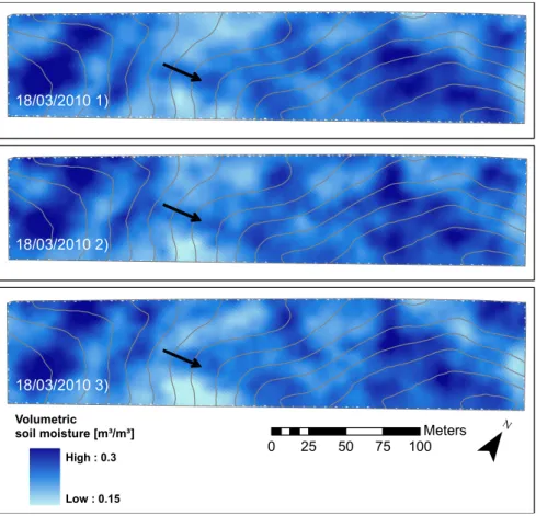
Figure


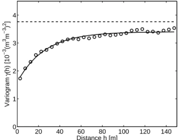
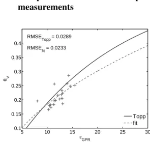
![Table 2: Summary of the soil moisture uncertainties [m 3 m − 3 ] determined by the different methods GPR inversion uncertainties (σ θ,GP R ) Comparison with soil sampling (RMSE f it )](https://thumb-eu.123doks.com/thumbv2/123doknet/5599236.134688/15.892.128.768.141.342/summary-uncertainties-determined-different-inversion-uncertainties-comparison-sampling.webp)
Documents relatifs
The fusion approaches included a neural network approach (Rodriguez-Fernandez et al., this conference session HS6.4), a regression approach (Wigneron et al., 2004), and an
Arnaud Mialon, Al Bitar Ahmad, Lucie Berthon, Simone Bircher, François Cabot, Maria-José Escorihuela, Delphine Leroux, Olivier Merlin, Nathalie. Novello, Thierry Pellarin,
Surface emissivity can then be related to the moisture content in the first few centimeters of soil, and, after some surface roughness and temperature corrections, to the sea
For the SMAP core validation sites (see Section 2.2.1), a validation grid that minimizes upscaling errors has been developed as described in Colliander et al. other satellite and
Surface soil moisture estimated at the 1km scale from transect measurements (vertical axis) and from the local Agoufou top of hillslope station measurements to which was applied
Kauzar Saleh Contell, Yann H. Kerr, Gilles Boulet, Maria-José Escorihuela, Philippe Maisongrande, et al.. Main outcomes of the CoSMOS/NAFE campaign for the validation of the SMOS
L’archive ouverte pluridisciplinaire HAL, est destinée au dépôt et à la diffusion de documents scientifiques de niveau recherche, publiés ou non, émanant des
remote sensing missions, 3) soil moisture monitoring networks, and 4) applications of large scale 132.. soil
