Woody plant cover estimation in drylands from Earth Observation based seasonal metrics
Texte intégral
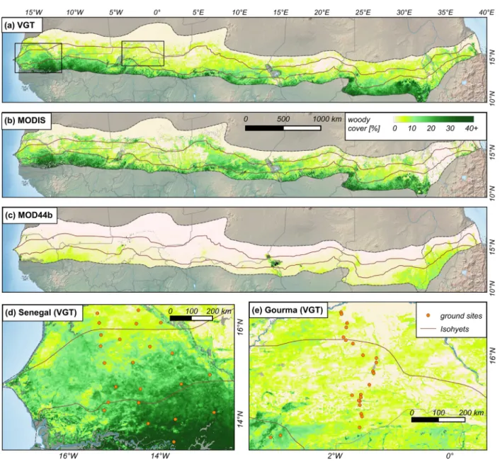
Figure


Documents relatifs
The Diancang Shan, a horst massif within the Red River fault zone in Yunnan, Peo- ple's Republic of China, preserves a structural, petrological, and thermal
This section analyzes three precedents of peer to peer: fragmented, distributed, or collective property among unidentified, evolving group of peers in legal history – the bundle
What we want to do in this talk is firstly to explain when (§1) and why (§2) a presupposition trigger becomes obligatory in the very case where it is redundant, and secondly
While it is natural for us to talk about cumulated gain over time, the traditional cumulated gain measures have substi- tuted document rank for time and implicitly model a user
Our EUREKA financed technology development project aimed to provide information about the location, the volume and the dynamic tendencies of these biomass sites in order
Thus, the contributions of this paper are twofold: (i) An experimental analysis of the amount of data necessary to successfully achieve supervised learning, and moreover, of
Direct commu- nication will be possible during the so-called AOS pe- riods ; in periods of no communication (LOS), HKTM data are recorded onboard whi le HRD data are
geochemical distribution of organic carbon in early land plants: a novel approach. Image Processing
