HAL Id: halshs-02357977
https://halshs.archives-ouvertes.fr/halshs-02357977
Submitted on 20 Nov 2019HAL is a multi-disciplinary open access archive for the deposit and dissemination of sci-entific research documents, whether they are pub-lished or not. The documents may come from teaching and research institutions in France or abroad, or from public or private research centers.
L’archive ouverte pluridisciplinaire HAL, est destinée au dépôt et à la diffusion de documents scientifiques de niveau recherche, publiés ou non, émanant des établissements d’enseignement et de recherche français ou étrangers, des laboratoires publics ou privés.
Medieval Southern Alpine Mountains: perceptions and
interweaving diverse sources
Aline Durand
To cite this version:
Aline Durand. Medieval Southern Alpine Mountains: perceptions and interweaving diverse sources. Retamero Felix, Schellerup Ingrid and Davis Althea. Making agro-pastoral landscapes in pre-industrial societies: choices, stability and change, Earth Series volume 3, Oxbow, pp.251-270, 2016, 9781842173596. �halshs-02357977�
This pdf of your paper in Agricultural and Pastoral Landscapes in Pre-Industrial
Society (EARTH Volume 3)
belongs to the publishers Oxbow Books and it is their
copyright.
As author you are licenced to make up to 50 offprints from it, but beyond
that you may not publish it on the World Wide Web until three years from
publication (December 2018), unless the site is a limited access intranet
(password protected). If you have queries about this please contact the editorial
department at Oxbow Books ([email protected]).
AGRICULTURAL AND
PASTORAL LANDSCAPES IN
PRE-INDUSTRIAL SOCIETY
Choices, Stability and Change
edited by
Fèlix Retamero, Inge Schjellerup
and Althea Davies
© Oxbow Books 2015
Oxford & Philadelphiaan
offprint
from
Hardcover Edition: ISBN 978-1-84217-359-6
Digital Edition: ISBN 978-1-78297-012-5
Other Volumes in this Series
Plants and People: Choices and Diversity through Time
(EARTH Volume 1)
Exploring and Explaining Diversity in Agricultural Technology
Early Agricultural Remnants
and Technical Heritage (EARTH):
8,000 Years of Resilience and Innovation
Volume 3
Series Editors
Patricia C. Anderson and Leonor Peña-Chocarro
Coordinating Editor
Published in the United Kingdom in 2016 by OXBOW BOOKS
10 Hythe Bridge Street, Oxford OX1 2EW and in the United States by
OXBOW BOOKS
1950 Lawrence Road, Havertown, PA 19083 © Oxbow Books and the individual authors 2016 Hardcover Edition: ISBN 978-1-84217-359-6 Digital Edition: ISBN 978-1-78297-012-5
A CIP record for this book is available from the British Library Library of Congress Cataloging-in-Publication Data
Agricultural and pastoral landscapes in pre-industrial society : choices, stability and change / edited by Fèlix Retamero, Inge Schjellerup and Althea Davies.
pages cm. -- (Early agricultural remnants and technical heritage (EARTH) ; volume 3) Includes bibliographical references and index.
ISBN 978-1-84217-359-6 (hardback) -- ISBN 978-1-78297-012-5 (epub) -- ISBN 978-1-78297-014-9 (pdf) -- ISBN 978-1-78297-013-2 (mobi) 1. Agriculture--History--To 1500. 978-1-78297-013-2. Pastoral systems--History--to 1500. I. Retamero, Fèlix, editor of compilation. II. Schjellerup, Inge, editor of compilation. III. Davies, Althea, editor of compilation.
S433.A47 2015 630.93--dc23
2015026373
All rights reserved. No part of this book may be reproduced or transmitted in any form or by any means, electronic or mechanical including photocopying, recording or by any information storage and retrieval system, without permission from the publisher in writing.
Printed in the United Kingdom by Short Run Press, Exeter For a complete list of Oxbow titles, please contact: UNITED KINGDOM
Oxbow Books
Telephone (01865) 241249, Fax (01865) 794449 Email: [email protected]
www.oxbowbooks.com UNITED STATES OF AMERICA Oxbow Books
Telephone (800) 791-9354, Fax (610) 853-9146 Email: [email protected] www.casemateacademic.com/oxbow Oxbow Books is part of the Casemate Group
Cover illustrations
Inca terraces from Pisac, Peru. Image: Inge Schjellerup
Horses grazing near the Christian temple of San Salvador de Valdediós (9th century; Asturias. Spain). 2011. Image: Fèlix Retamero Agricultural terraces in the gorge of Algendar (Ferreries. Minorca). 2005. Image: Fèlix Retamero
We would like to dedicate this book to
Sofus Christiansen
Professor of Geography at the University of Copenhagen, Denmark, who was an inspiring and active member of the EARTH Steering Committee and Programme from 2004 to 2007, when he passed away suddenly.
His main research area was Agricultural Geography, especially farming systems and ecological cultural geography. He was a member of the Research Council of the Institute of Development Research from 1971 until 1974, a board member of the Nordic Africa Institute in Uppsala, Sweden, a member of the Danish Academy of Sciences, and a member of the National Committee for Geography. He also served as Scientific Advisor to the Ministry of Foreign Affairs of Denmark. In 1988, he was awarded the Royal Danish Geographical Society’s Galathea Medal.
Sofus’ interactions were always made even more pleasurable by his legendary humour. This, together with his vast knowledge of worldwide geography, helped launch new initiatives and provided the basis for interesting and entertaining discussions for the members of this programme and the authors of this book, particularly concerning the relationship between nature, environment and humans. We are grateful for his help and inspiration
and also to
Miquel Barceló
Professor of Medieval History at the Autonomous University of Barcelona. He passed away in November 2013, in Porto Colom, Felanitx (Mallorca), his beloved country. He participated in the preliminary meetings of the EARTH program and gave helpful advice to put it together. He was a full, then an honorary member of the Steering Committee and enriched discussions with his stimulating ideas. Miquel’s research activity encompassed many topics of medieval history, including monetary history, fiscality, and agrarian history, among others. His work on the peasant migrations to al-Andalus of Arab and Berber groups was pioneering in the knowledge of al-Andalus. He provided the basis for the study of the Andalusi irrigation systems and of the transformations introduced in the aftermath of the Christian conquests, especiallly during the 13th century, by means of textual and archaeological evidence. Above all, he was an ‘historian of exterminations’, as he claimed to be. The connection between the Iberian conquests in al-Andalus and overseas between the 12th and the 16th centuries was his later research interest. He passed away when he was working on the effects of the Spanish conquest of the Americas through the study of the works of Las Casas.
We all miss his razor-sharp intelligence and his acute sense of humour. as well as to
Urve Miller
Professor at the Department of Quaternary Research at the University of Stockholm, after working at the Geological Survey of Sweden as its first female State Geologist, was a warm and supportive member of the EARTH Steering Committee, and a founding member of the program. She worked particularly closely with Team 3, dealing with landscapes, who have authored most of the articles in this book.
Urve was a pioneer in the area of microfossils, including phytoliths and especially diatoms and their application to archaeology, beginning in the 1960s, observing their structure with the newly invented SEM. As coordinator of the Palaeoecology Network of PACT, she fought to have biological methods included in archaeometry, which was at first restricted in practice to physics and chemistry, and she also championed cooperation between human and natural sciences, setting the stage for the approach used in this program and in this book. Urve saw to it that EARTH became a separate network of PACT (see preface), accredited by the European Parliament in Strasburg, prior to its funding by the European Science Foundation. She encouraged and supported students from all over the world, including teaching in her native Estonia. She passed away in June 2015, just before turning 85. Her enthusiasm and commitment to the interdisciplinary approach and her cheery encouragement and loyalty were particularly influential in building the cooperation leading to this publication.
and, finally, also to
Lydia Zapata
Archaeobotanist and ethnobotanist who was a much appreciated member of team one in the EARTH project, whose work was also relevant to this volume, passed away in January 2015, at the age of 49. She was a lecturer at the Department of Geography, Prehistory and Archaeology at the University of the Basque Country, and had studied archaeobotany at the Institute of Archaeology (UCL) with Gordon Hillman. In the 1990s, she was part of a pioneering group of researchers who developed the field of archeobotanical studies in Spain, contributing new and relevant data to the knowledge of the first agriculture in the Iberian Peninsula. She was also involved in the study of the origin of agriculture in the Near East. Ethnobotany being her second passion, she focused her work on traditional agriculture and plant artisanry in Spain and Northern Morocco. Members of this program and many others in the research community appreciated the unique opportunity of knowing Lydia, an intelligent, sensitive and enthusiastic soul, and laughing and working with her. As it is said in the Basque language which she loved so much, beti gure bihotzean egongo zara, Lydia, Goian Bego.
The European Science Foundation (ESF) is an independent, non-governmental organisation, the members of which are eighty national funding agencies, research-performing agencies, academies and learned societies from thirty countries.
The strength of the ESF lies in the influential membership and in its ability to bring together the different domains of European science in order to meet the challenges of the future.
Since its establishment in 1974, the ESF, which has its headquarters in Strasbourg with offices in Brussels and Ostend, has assembled a host of organisations that span all disciplines of science, to create a common platform for cross-border cooperation in Europe.
The ESF is dedicated to promoting collaboration in scientific research, funding of research and science policy across Europe. Through its activities and instruments the ESF has made major contributions to science in a global context. The ESF covers the following scientific domains:
• Humanities
• Life, Earth and Environmental Sciences • Medical Sciences
• Physical and Engineering Sciences • Social Sciences
• Marine Sciences
Fonds National de la Recherche Scientifique (FNRS) –
National Fund for Scientific Research, Belgium
Fonds voor Wetenschappelijk Onderzoek Vlaanderen (FWO) – Research Foundation Flanders, Belgium Grantová agentura České republiky (GAČR) – Czech
Science Foundation, Czech Republic
Akademie věd České republiky (ASCR) – Academy of
Sciences of the Czech Republic, Czech Republic
Det Frie Forskningsråd – Kultur og Kommunikation (FKK) – The Danish Council for Independent Research
– Humanities, Demark
Eesti Teadusfond (ETF) – Estonian Science Foundation,
Estonia
Suomen Akatemia/Finlands Akademi – Academy of
Finland, Finland
Centre National de la Recherche Scientifique (CNRS) –
National Centre for Scientific Research, France
Deutsche Forschungsgemeinschaft (DFG) – German
Research Foundation, Germany
An Chomhairle um Thaighde sna Dána agus sna hEolaíochtaí Sóisialta (IRCHSS) – Irish Research Council
for the Humanities and Social Sciences, Ireland
Nederlandse Organisatie voor Wetenschappelijk Onderzoek (NWO) – Netherlands Organisation for
Scientific Research, The Netherlands
Norges Forskningsråd – Research Council of Norway,
Norway
Consejo Superior de Investigaciones Científicas (CSIC)
– Council for Scientific Research, Spain
Vetenskapsrådet (VR) – Swedish Research Council, Sweden Schweizerischer Nationalfonds (SNF) – Swiss National
Science Foundation, Switzerland
Arts and Humanities Research Council (AHRC), United
Kingdom
ESF MISSION
ESF MEMBER ORGANISATIONS FUNDING THE EARTH NETWORKING
PROGRAMME AND PUBLICATIONS
ESF member organisations funding the EARTH Networking Programme and publications ...vi
Foreword...ix
Preface ...xi
Introduction: Strategies that Shaped Non-Industrial Landscapes... xx
SECTION 1: Landnám
Introduction – Fèlix Retamero ... 31. Neolithic Agriculture in Mediterranean Wetlands: A Complement to Pastoralism at Polje Čepić (Istria, Croatia) – Andrea L. Balbo ...5
2. Desert Farming in the Southern ‘Araba Valley, Israel, 2nd Century BCE to 11th Century CE – Uzi Avner ...19
3. The Northern Frontier – North Atlantic Farming During the Viking and Middle Ages – Christian Keller, Sophia Perdikaris ...37
4. Becoming Islanders. Migration and Settlement in the Balearic Islands (10th–13th Centuries) – Helena Kirchner, Fèlix Retamero ...57
5. The Transformation of Riversides: The Example of the Alluvial Valleys of Languedoc and the Lower Rhône Valley during the Medieval Period (9th–13th Centuries) – Aline Durand ...79
6. The Formation of New Villages on the Northeastern Slopes of the Andes – Inge Schjellerup ...93
SECTION 2: Fields and Field Systems
Introduction – Valter Lang ...1077. Fields in Prehistoric Bohemia – Fact and Fiction – Dagmar Dreslerová ...109
8. Stability and Changes in the Agricultural Use of Limestone Soils in Northern Estonia – Valter Lang ..125
9. Prehistoric Agriculture and the Ancient Fields of Orijärvi, Finland – Esa Mikkola, Teija Alenius, Mika Lavento ...143
10. Ridge and Furrow Fields – Field Systems ca. 1000–1800 as a Stabilising Factor in an Agricultural Society – a Danish Example – Per Grau Møller ...159
11. Coping with Gravity: The Case of Mas L’Agustí (Montseny Mountains, Catalonia, Spain, ca. 15th–18th centuries) – Fèlix Retamero ...173
12. Landscape Change and Agricultural Terraces in the Peruvian Andes – Inge Schjellerup ...187
13. Managing Slopes for Agricultural Purposes: Terrace Morphology in Andalusi Hydraulic Systems – Eugènia Sitjes ...201
14. Agricultural Activities in the 10th–13th Century CE in Brussels (Belgium): An Interdisciplinary Approach – Luc Vrydaghs, Yannick Devos, Paulo Charruadas, Linda Scott Cummings, Ann Degraeve ...221
Contents
SECTION 3: Agro-Pastoralism
Introduction – Thomas K. Schippers ... 237
15. Pastoralism, Landscape and Woodland Use in the Late Neolithic in Southern Germany – Niels Bleicher ...239
16. Medieval Southern Alpine Mountains: Perceptions and Diverse Interweaving Sources – Aline Durand...253
17. Flexibility in Upland Farming: Pollen Evidence for the Role of Seasonal Pastures in the Scottish Farm Economy from ca. 1600–1900 – Althea L. Davies ...271
18. Moving Up and Down. Two Cases of Seasonal Family Dwellings in Mountainous Areas: Mid-Norway and the Southwestern Alps – Karoline Daugstad, Thomas K. Schippers ...289
19. An Example of Vernacular Agro-Pastoral Landscape Perception: The Provençal Transhumant Shepherd – Thomas K. Schippers ...305
Annexes
Contributors...314The EARTH Steering Committee (2004–2009) ...316
EARTH Programme Members...316
Scientific Networking Workshops Contributing to the Contents of this Book ...319
16 Medieval Southern Alpine
Mountains: Perceptions and Diverse
Interweaving Sources
Aline Durand
Introduction
In France, mountains, and especially medieval mountains, were long considered marginal, immobile, motionless, in the sense of static, without an historical perspective and dynamic evolution. Knowledge and representations were based on an older state of research and this was all the more true in that written documents were thought to be rather scarce. In fact, mountains only seemed deserted and immobile, because they were neglected by historians and archaeologists (Guichonnet et al. 1980, I:165), which prompted J.-P. Boyer (1990, 6) to write that they represented a wasteland in erudition and H. Falque-Vert (1997, 9) to note that above 1000 m, there is no more history. Indeed, since G. Duby worked on the southern Alps (1958, 1961, 1973), few medievalist historians (Bligny 1957; Fournier 1962; Rotelli 1973; Fournier and Fournier 1983; Charbonnier 1980; Boyer 1990; Dubuis 1990) have placed mountains at the centre of their interests. The Alpine survey carried out by R. Favier (1996) demonstrated this a decade ago.
Nonetheless, as early as the first edition of La Méditerranée et le monde méditerranéen à l’époque de Philippe II in 1949, F. Braudel wrote the founding comments on the history of mountains, because, in his opinion, mountains are deeply woven into the fabric of the Mediterranean world. However, he confines them to a ‘quasi-immobile history’, indissociably linked to that of the plains. L. Zanzi
(1996a, 1996b) clearly explained that the paradigm of the centre and periphery utilised by I. Wallerstein and F. Braudel in their economic analysis of the world could in no way be applied to Alpine spaces. In a Braudelian perspective, mountain eco-history can only be an invariable framework over a longer time span – the longue durée (Zanzi 1996a, 1996b) – and cannot be examined by itself without taking into account a Mediterranean perspective.
On top of this, higher areas with few exceptions (such as the route of the Clermont-Ferrand-Montpellier A75 or the Gap-Aix-en-Provence A51 highways), lie outside the policies supporting large construction works that have led to the explosion in preventive archaeology over the last fifteen years. The few archaeological operations that took place related to castellology or mining archaeology (Ginouvez and Schneider 1988; Journot 1990; Bailly-Maître and Bruno-Dupraz 1994; Colin et al. 1996; Ancel 1998a, 1998b; Mouton 2003). Charavines is the sole example to the contrary and an exception to the rule (Colardelle and Verdel 1993). In Oisans, and the Dévoluy, the ‘High Villages’ programme intends to represent a survey of knowledge on the subject. Launched jointly by the Dauphinois Museum, the Queyras Natural Park, and the Departmental Archives of the High Alps, coordinated by C. Mazard, the programme is presently in abeyance and the first results have not been published. The same is true in Italy, where archaeological research has been devoted mainly to churches, less to castles and not
ALINE dURANd 252
at all to rural dwellings (Mercando and Micheletto 1998), and equally little to material culture and crop systems, often frozen into intemporality (Renzetti and Taiani 2002) or folklorised in an artificial and spectacular fabrication of older traditions (Crettaz, 1992). It is only in Switzerland that pastoral structures have been at the heart of archaeological research criteria concerning high mountain areas and given rise to a recognised branch of medieval archaeology (Meyer et al. 1998; Meyer 2002). This is because prospection and then archaeological excavation are more difficult than in the plains, due to the inaccessibility of sites (vegetation cover, steep inclines and climatic conditions for the Alpine sites). It has only been within the last fifteen years that the subject has come to the forefront of researchers’ concerns and that mountain archaeology has developed, first in Switzerland, then in the Pyrenees and finally in the French Alps, particularly at high altitudes (> 1700 m to 1800 m) associated with palaeoenvironmental research and a new reading of written documents. This has made it possible to historicise mountains. There is testimony to this in France in a flowering of theses and publications (Falque-Vert 1997; Cursente 1998; Fau 1998, 2003; Laffont 2009; Bréchon 2000; Carrier 2001; Carrier and Mouton 2010; Boyer 2001, 2002; Rendu 2003a, Mouthon 2009, 2010, 2011) and recent round tables and colloquia (Thomasset and James-Raoul 2000; Rendu 2003b; SHMESP 2004; Tzortis and Delestre 2010). At the crossroads of archaeology, history and ethnology, Ch. Rendu’s thesis (2000, 2003a, 2003b) dedicated to the Enveig catchment area in Cerdagne has been the high point in all this rethinking of stereotypes about mountains. This work has shown how the longue durée of history is a dynamic, innovative time, combining acceleration, upswings, downswings, and not some time frozen in immobility and stability: the historicisation of practices and pastoral social spaces is magnificently demonstrated, especially for the Middle Ages, whose apparent paralysis at certain times must paradoxically be interpreted as a sign of growth. Pastoral mountain spaces are now on the march (Rendu 2003a, 17).
For the Alpine arc, the creation of an Institute for Alpine History in Lugano that publishes a yearly journal entirely dedicated to Alpine history (Bergier 1996) is emblematic of the historiographical emancipation from national borders and the
construction of an independent object of study, since Alpine history research still cannot claim an important place (Mathieu 1996), even in Switzerland, where the Alps figure among national monuments and symbols. From Slovenia to Italy, the Alps were long seen only through the prism of extra-Alpine material (Coppola 1996; Mathis 1996; Mihelic 1996; Bergier 1997c) and perceived by lowlanders, who repeated as if by rote the same impressions (Bergier 1997a). This Institute, dedicated to Alpine historical research, is also to be interdisciplinary: there can be no history of the Alps without disciplinary crossing-over. The historian J.-F. Bergier (1996) poses this as a sine qua non condition in the founding manifesto of the journal Histoire des Alpes:
‘The coherence of the Alpine milieu calls, more than any other large region, for this conjugated approach of multiple sources of knowledge, including recourse to the natural sciences. Here, more than anywhere else, history involves the confrontation between Human and Nature, in any case a permanent relationship and equilibrium that is difficult to respect. What is more, Nature offers historians sources of information they do not find anywhere else… all these forms of knowledge, generally rather foreign to historians, are necessary to inform their interpretations of Alpine realities and the events they bear witness to.’
This article fits precisely into this historiographic perspective. It will attempt to do justice to the history of medieval southern Alpine mountains, especially the French southern Alpine area, and to how they were perceived, on the basis of several types of sources: firstly, literary sources written by the lettered, which thus provide a learned perception of medieval mountains; secondly, diplomatic sources governing the relations between the powerful and country people, principally through the prism of fiscal and legal concerns linked to land-holding rights and which are the fundamental stamping ground of rural-history researchers; these can be dealt with in conjunction with agronomic treatises based on practical knowledge; and, finally, archaeological investigation into high-altitude areas carried out over the last 15 years by various excavation teams, including those for which bio-archaeological inquiries have played an important role. Each of these sources tends to provide a particular vision of mountains. Literary sources describe mountains that may be almost imaginary, or at the very least, idealised because viewed by people foreign to the milieu. Medieval diplomas and charters, which have been exhaustively examined for the period before 1220, show us the details of
16. MEdIEvAL SOUTHERN ALPINE MOUNTAINS 253 how entwined land rights and rents which affected
holdings were, but their objective is not really to portray mountain landscapes, since they especially emphasise cultivated spaces, notably for grain production, and usually do not touch upon what this sort of document calls the incultum, the areas in village territory that are not regularly cultivated. Nor do archaeological sources reveal the totality of historical realia, since only remains made of durable materials are buried and conserved, whereas structures made of perishable material, such as wood, for example, are irretrievably lost, except in very unusual circumstances. The sources utilised in this article can only elucidate the situation in some particular valleys and we must emphasise that heterogeneity is the main characteristic of mountain life. Hence, each of these sources can only provide us with a fragment of historical reality and are pieces of a jigsaw puzzle that fit into a whole and from these sources we may draw conclusions for the whole of the southern Alps. This is why it is so fruitful to examine them side-by-side in order to have the most complete picture we can and to perceive as nearly as possible what these southern Alpine mountains were like in the Middle Ages (Fig. 16.1).
Mountains as Seen by a 13th-century
Intellectual
A son of the English nobility, Gervase of Tilbury (1152/53–1234), received a sound clerical education at the court of Henry II, then in the Reims Cathedral school and finally in the prestigious University of Bologna. He then entered the service of the young Emperor Henry II and later that of William II the Good, the last Norman king of Sicily. Thus it was that he frequented the court in Palermo, a rich and cosmopolitan hotbed of intellectual activity, where scholars and literati of every kind rubbed shoulders and different cultures – Jewish, Arab and Christian – mixed. Around 1190, Gervase left Italy for Arles, where he took up residence and married a relative of the Archbishop of Arles, Humbert d’Eyguières, thus entering an urban knightly family that was powerful and influential in Provence. At the end of his life, Gervase was notary to Otto of Lüneburg, nephew of the Emperor Otto IV. His career is an archetype of an ecclesiastical life in the 13th century.
As early as 1183, Gervase was planning to write a survey of ‘marvels’ in the ecclesiastical provinces and to give it to the young king as an entertainment, but it is only around 1210–1214 that the Otia Imperialia, the Book of Marvels dedicated to Otto IV of Brunswick, was to be completed. This work contains one of the oldest descriptions of the southern Alpine mountains:
‘… in Subalpine Gaul, among the highest peaks, chamois are found. They taste like goats, but are superior to them in having a finer hide. The hunting of the animal is based on a strategy involving dangerous precipices… So the hunter sets about luring the chamois down from the hills; meanwhile, he stations one of his companions on a narrow path on the mountain-side, in order that, when a beast comes that way, he may prevent it from running away or passing by, and drive it down to a precipice among the sheer drops of those valleys.’
‘In the kingdom of Arles and the province of Embrun there is a place from where it is possible to descend into Italy from among the highest peaks of the Alps. The route is easy in summer, and short, but it is very dangerous to travel along it. The locals have given this place the name of the Valley of Lantosque. If anyone coughs or shouts at its highest point, the frozen snow is immediately dislodged from the high crags and gathers volume until in a vast mass, it overwhelms any people passing through, casting them into a bottomless abyss, it hurls them to their death.’ (Banks and Binns 2002, 683, 819)
The English clerk describes the mountain as ‘wild’, dangerous, empty of men and crops. The southern Alps seem to him to be a cold and frozen, treeless desert, frequented only by a few hunters. It is an area only to be crossed through without stopping because humans are not masters of it, contrary to other regions described in the Book of Marvels, like the Camargue, an area where landscapes are enlivened by one or several activities, either agricultural or artisanal. There is nothing like this in the high, southern Alpine mountains, which appear frozen, static and threatening to Gervase, first and most of all, because they are unknown. Yet, Gervase undertook the ascension of Mont Aiguille (2086 m) in the Vercors (Thomasset and James-Raoul 2000, 15) and he thus, he possessed some concrete knowledge of mountains, even if he had not actually lived there.
This highly idealised and naive conception of high mountains was shared by all medieval intellectuals, who presented a very simplified and highly formatted image of mountain ranges (Thomasset
ALINE dURANd 254
and James-Raoul 2000, 12). We might look here towards the influence of the hermit or monastic model on this vision of mountains developed by intellectuals who nearly all had a clerical education. The vision developed by Gervase of Tilbury corresponds to that of a place cut off from the real, earthly world and hence falling into the category of deserta, those remote spots that lent themselves so well to meditation and prayer, but that were in fact a hostile wilderness.
After studying geographical discourse and the emergence of the concepts linked to it in the lettered milieu, P. Gautier-Dalché (2000) concluded that the perception of mountain spaces was given more nuance in the course of the 13th century, whereas he observed an absence of mountains as specific places and especially as landscapes in the earlier medieval ‘geographical’ texts. At the end of the 13th century, a debate on how mountains came into being among the encyclopaedists involved the
Zoom 4 Auvergne Burgundy Centre Picardie Lorraine Franche-Comté Provence-Alpes Côte d’Azur Midi-Pyrénées Languedoc-Roussillon Champagne Ardennes Rhône Alpes Aquitaine Limousin " ) " ) " ) " ) " ) " ) " ) " ) " ) " ) " " ) " ) " ) " ) ! ( ! ( Charavines Aix-en-Provence Montpellier Marseille Enveig Arles Valence Lyon Geneva PARIS Reims Dijon Orléans Grenoble Clermont-Ferrand Crau Camargue 2 1
E
0 75 150Km Gulf of Lion Mediterranean Sea SPAIN ITALY SWITZERLAND A16. MEdIEvAL SOUTHERN ALPINE MOUNTAINS 255
development of ‘geological’ thinking (Ducos 2000). Gervase of Tilbury’s Book of Marvels is neither a geographical source, nor an encyclopaedic source, but it does grant mountains a specific place in the medieval world as early as the first third of the 13th century: the English clerk is a precursor in the sense that he recognises a special status for mountains. However, there is another side to Gervase’s passages. The vision of high places that he channels into constructing an image passed on to posterity: all too often, mountains were to be described as untamed and petrified, empty and without human life because they are too rugged to have been conquered and mastered by humankind. This implied that mountains do not have a history, because they are intemporal, hence typical. This image long prevailed and was a handicap to a real approach to and grasp of what mountains are. Hence, this cliché about the immobile, stable and untamed mountains probably had its origins in the Middle Ages and the Book of Marvels was paramount in contributing to it.
Mountains Seen Through Sources from
the Rural World
In opposition to the vision of a scholar like Gervase of Tilbury, practical contemporary written sources – whether in agronomic treatises or practical documentation – reflects an entirely different image of the southern Alpine mountains, especially the higher mountain areas, and it is that of a tamed, mastered, colonised, utilised and cultivate space, not at all immobile and frozen in some stability (Fig. 16.1).
As early as 739, in his famous will, Abbon, abbot of Novalesa Abbey, founded in 726 in the valley of Suse, described the Briançon, Embrun and Champsaur area (Fig. 16.1) as an organised and utilised landscape. When he enumerates what makes up his holdings, the term ‘alpes’ appears and with the same standing as woods, meadows, streams, cum silvis, pratis, alpibus, aquis aquarumve decursibus (Geary 1986).1 He notes that some of these
Fig. 16.1. A: Map of France with its political regions, and 1) Novalesa Abbey; 2) the church of Saint-Pierre-de-la-Grande-Chartreuse. B: Zoom on the study region with the towns mentioned in the text and the lakes of 1) Faudon and 2) Lauzons; 3) the Freissinières valley; 4) Ecrins National Park and Plateau de Faravel; 5) the vercors Plateau.. Map: R. Lugon, J. C. Loubier and A. Chevalier.
1
2
3
Provence-Alpes-Côte d’Azur
Rhône-Alpes
" " " " " " " "!
!
Charavines Bovinant Ancelle Vallouise Tallard Champsaur Névache Montgenèvre Embrun Briançon#
#
Massif du DevoluyE
Mont Pelvoux 4#
Mont CenisE
Grenoble Sisteron5
Saint-Peter-of- the Great-Chartreuse Saint Peter of Novalaise " " "E
50
25
0
Km
ITALY
BALINE dURANd 256
alpes are near Mont Cenis (2084 m), a valuable first indication of altitude and the first place, perhaps, with pastoral activity. Several other Gapençais and Embrun possessions are sites of pastoral activity, including Saint-Bonnet-de-Champsaur, Ancelle and Tallard (Fig. 16.1). This terms alp (alpes in the plural) is repeated in the cartulary of the marshalry of Oulx, the oldest southern Alpine document, dating from around the year 1000, that portrays all the eastern part of the southern Alpine massif from Névache to Vallouise, including the Embrunais (Fig. 16.1). Alp appears in 1042 as a delineated and territorialised space, even at higher altitudes, since the Montgenèvre (1854 m) and Mont Cenis passes and their alpes separate the kingdoms of Italy and Burgundy:
‘… sicuti detinent montes qui nuncupantur Genevus et Ciniso seu
mons ille in quo (var. et quod) Altareto dicitur et sicuti detinent
alpes inter regnum Burgundie et Italicum regnum …’. (Cart. Oulx n°1 p. 2, 1042)
‘that is, the mountains named Genèvre and Cenis or the one (?) named Lautaret and thus the alpes between the kingdoms of Burgundy and Italy’. (transl. A. Durand)
Here, too, the link between the alpes and the high mountains, right up to the highest summits, is clear, but their pastoral role is not emphasised, although it is in later acts. It is not until 1101 that we can grasp the exact meaning of the term alp, thanks to the brief on dues and villain labour composed for Vallouis:
‘Tascam vero et pascherios (var. pasquerios). unum de alpibus
et alium de festivitate sancti Michaelis’. (Cart. Oulx n°80 p. 83, 1101)
‘The tasques and rents linked to pasturage rights. One at the time of the alpes, the other for the Feast of Saint Michael’. (transl. A. Durand)
This passage links alp not only to a spatial reality connected with a position at high altitude as on the Montgenèvre or the Mont-Cenis, but to a period of time: alp-alpis thus designates the time when the mountain space is occupied for pastoral activity involving the payment of rents, a rent proportional to the profits made and the increase in the flocks, the tasque, and the pasturage rights. This means that the alp is not utilised continuously throughout the entire year: since there are empty and full times, it is a syncopated occupation. In these conditions, pasturage can only be intermittent because of the
snow-cover season and concerns only the summer period. So alpes refers to summer pasture in high mountains. Furthermore, the 12th-century sources confirm the link, only suggested before, between alp and flocks, thus clearly outlining the organisation and spatial definition. In this period, the alp is above all made up of meadows and frequently bounded or crossed by streams:
‘… alpem quem habemus prope Petram Galdemar qui dividitur
cum eo quem tenet Arnulfus de Pineta et Vincentius sicut rivulus usque ad collem de Jazenel …’. (Cart. Durbon n°4 p. 5, 1121). ‘the alp which we possess near the Gaudemar Stone and is bordered by the alp held by Arnulf de Pineta et Vincent from the little stream to the mountain of Jazenel’. (transl. A. Durand)
In the alp of Bovinant, near Grenoble, the peasants of the villa of Saint-Pierre-de-la-Grande-Chartreuse harvested hay:
‘… alpem de Bovinant…quidam ruricole ville Cartusie ascenderunt
predictam alpam et collegerunt ibi fenum’. (B. Bligny, Recueil… n°19 p. 49, before 1133)
‘the alp de Bovinant … which the peasants of villa Saint-Pierre-de-la-Grande-Chartreuse undertook to climb and harvested hay’. (transl. A. Durand).
In order to reach the area, they had to ascendere, climb the alp, which indicates that the alpis is located well above the inhabited zone and the valley lands. In a highland context, the use of the verb ascendere suggests both the time involved in the climb and its difficulty. This is still another indication linking alp to high mountains. In the 12th century, the description of the alpes of the Bardonnecchia valley clearly places them on the mountains, so the acts no longer leave any doubt about the pastoral character of this space:
‘… habet alpem unam que dicitur Mercorinaca in monte
Capatenicus et…aliam alpem dimidiam que pertinet ad Vaionaces in monte qui dicitur Gescone’. (cart. Oulx n°212 p. 221, 13th century)
and
‘… pro hac venditione accepi ab eisdem fratribus ducentos
sexaginta solidos Valentiniensis monete, decem oves et quinque agnos, arietem unum et canem unum’.
‘…. for this sale – half of the Fessalaa – I received from the monks 260 Valentinois sous, ten ewes, five lambs, a ram and a dog’. (ca. 1148–1150 CE; Roman 1923)
16. MEdIEvAL SOUTHERN ALPINE MOUNTAINS 257 The lawsuits concerning co-pasturage that are to
be found here and there in the documentation from 1230 on confirm this definition.
The Liber ruralium commodorum, written between 1302 and 1308/09 by the Bolognese Pietro de’ Crescenzi, provides the best description of the way these pastoral lands in the mountains functioned. This agronomical treatise can be considered as the oldest one concerning the world of the southern Occident. The work reveals that mountains were divided into landscape sections according to a climatic gradient. The highest were called alpes, which Piero di Crescenzi defined as cold and snowy places where spruce, pine and larch grew… The term alpes thus refers to high mountains, above 1500 m. Our agronomist – an extremely rare occurrence – described in detail the usual agrarian cycles and what is of special import is that he actually saw them working with his own eyes, so that he unwittingly left us the work of an ethnologist. Without going into the details of these agrarian systems studied elsewhere (Durand 2004), we must nonetheless outline their main characteristics. They are mobile systems of extensive agriculture in which cereals have to spend 12 to 13 months underground and it is thus not possible to reseed the following year in the same place, so that the area under grain crops moves every three years. At very high altitudes (>1600–1700 m), rye, a rustic grain, is the best adapted to these difficult climatic conditions. This is why Pietro de’Crescenzi described them in Book III, dedicated to cereals and the chapter on rye. Corniolo Della Cornia, an important landowner and Perugian agronomist, takes Crescenzi’s descriptions up in the same place, adding some modifications in his own treatise, the Divina villa, written around 1410. This is why historians generally concluded that these were grain-crop systems, but this is not at all the case. Of course, agrarian cycles produce grain, but it is not their first calling. High-mountain agricultural cycles are entirely oriented towards the production of green forage, hay and the renewal of grass pasture thanks to intentional burning. They are grass-pasture systems with a short turnover of 7 to 8 years, meant above all to provide forage for stock, which obviously supposes associated pastoral activity.
Mobile agrarian systems are associated with the notion of marginal, primitive and rudimentary agriculture. The systems described by Italian agronomists from the 13th and the 15th centuries
for the middle and high mountains contradict this interpretation. The application of itinerant cultivation puts the lie to this image, because it intelligently controls the dynamics of scrub growth before it reaches the stage of pre-forest formation. At the crossroads of two antagonistic mechanisms (land clearing and deforestation versus resuccession and scrub encroachment), these cycles make up regulatory systems of the thresholds in Alpine land. What is at issue is finding a solution between the agricultural, pastoral and forest thresholds, all the while taking into account the specifics of altitude conditions, at times extreme, and the potential of the soils and the inclines that hinder any efforts at intensification. The objective is to manage the process of evolution of the high-altitude open spaces, that is, the degree of openness or closedness of the landscape: they spontaneously develop towards forest-type ecosystems, because most of the open vegetation forms are not in stable equilibrium. Hence, the land use types developed in the medieval high mountains represent a healthy compromise between the evolution of natural formations and the development imposed by southern Alpine society. In the same way, mobility and marginality are usually considered as going hand in hand, underwritten by the ruggedness of the environment. In fact, this highly elaborate organisation is quite well adapted to the Alpine milieu.
Archaeologists’ Mountains
In the southern Alps, the first archaeological work on land occupation in high mountains goes back to 1998 in a project centred on the history of pastoralism begun as a counterpart to the pioneering work in the Pyrenees (Rendu 2003a, 2003b). This was first coordinated by Ph. Columeau, the driving force behind Alpine pastoralism work and then by Ph. Leveau, who was highly committed to developing southern Alpine archaeology. The project laid the groundwork for longer-term research into pastoralism on the southern side of the Pelvoux massif (Leveau 2003b, 2009). This was at the origin of two archaeological programmes, carried out with the support of the National Park of the Écrins (Fig. 16.2) or in the high Champsaur (Palet Martinez 2001, 2002, 2003, Palet Martinez et al. 2003), the other in the Freissinières valley and on the Faravel plateau (Fig. 16.1; Walsh and Mocci
ALINE dURANd 258
2003; Walsh et al. 2006, 2007). The project was subsequently pursued, refocused and integrated into a broader diachronic programme coordinated by J.-L. de Beaulieu and Ph. Leveau, intitled La forêt et le troupeau dans les Alpes du Sud (département des Hautes-Alpes) du Tardiglaciaire à l’époque actuelle à l’interface des dynamiques naturelles et des dynamiques sociales (Forest and flock in the southern Alps, Hautes-Alpes Département, Programme Environnement Vie et Société, C.N.R.S.) (Leveau 2003b, Beaulieu et al. 2003). This project sought to compare archaeological, historical and palaeoecological information over a long time period.
The initial issues were defined by scholars in ancient history. Following the discovery of large sheepfolds of the Roman period in the Crau in Camargue (Badan et al. 1995), the hypothesis of long-radius transhumance was developed. Thus, the flocks would have gone up in summer to the Alpine pastures, because the Camargue plain was not large enough to keep all the livestock, so the beginnings of transhumance would have gone back to the Roman Empire. It was to verify this hypothesis that southern Alpine high-mountain archaeology was developed and the question of the origins of Provençal transhumance were no longer seen from the viewpoint of the plain, but from that of the mountains. This was fairly iconoclastic to the extent that the Aix school of medievalists led by N. Coulet,
P. Coste and L. Stouff had maintained for several decades that the great Provençal transhumances could not be any earlier than the 13th century for administrative reasons linked to the setting up of a state-type organisation.
The results built up over the last fifteen years have now revealed the importance of human occupation of land in the high mountains, since the archaeological prospection or excavation work has essentially been done at high or very high (1800–2400 m) altitudes. Temporary dwelling structures have been found as early as the Mesolithic, especially on the Faravel-Fangeas plateau (Fig. 16.2), proving a very old presence in these areas at 2100 m of altitude (Walsh et al. 2007). A small group of hunters was utilising the synergetic potential there in the early Holocene, at the very time when the maximum extension of the Würmian glaciations was later than in the northern Alps. This presence was continued again in the Neolithic, but it is especially during the Bronze Age that there is a concentration of evidence of pastoral occupation, probably including flock movement as early as this period. The Roman period is striking in its absence, while the other major phase of occupation takes place during the Middle Ages. So, this period stands out from the Carolingian (7th/8th century CE) to the 13th century. This chronology does not fit with the one usually proposed by medievalists, for whom the
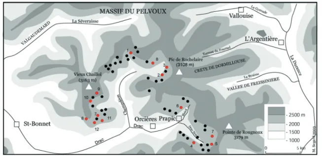
Fig. 16.2. Survey (black dots) and excavation (red dots) of pastoral sites in High Champsaur (France) since 1999: 1) Lac des Lauzons (2,190 m); 2) Cabane des Rougnous (2,075 m); 3)Cheval de Bois (2,375 m); 4) Pré Brunet (2,050 m); 5) Cabane de la Barre (2,200 m); 6) Jujal (2,140 m); 7) Chapeau Roux (2,340 m); 8) vallon de la vallette (2,179 m); 9) Jas du Cros (2,260 m); 10) Jas des Provençaux (1,980 m); 11) Clot Lamiande (2,140 m); 12) Col du Palastre (2,200 m). data J. M. Palet. dAO M. Segard.
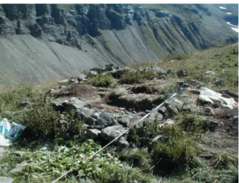
16. MEdIEvAL SOUTHERN ALPINE MOUNTAINS 259 some of these pastoral dwellings would have been made of wood. The 15th-century fresco calendar of Torre Aquila in Trent includes a scene of pastoral activities on a high-altitude mountainside: the cattle graze above, while milking and butter- and cheese-making are carried on at the bottom of the slope where there are three wooden huts used both as dwellings and workshops or cheese-making huts. The huts are very simple, either without an opening or with a single opening. This picture magnificently illustrates what an Alpine pasture might have looked like at the end of the Middle Ages and it also demonstrates that even archaeology can hope to grasp only a part of the real historical picture. These huts frozen in time and uncovered by archaeologists are usually built on berms. Photographs (Fig. 16.3 and Fig. 16.4) show how one of these huts is set into a very steep slope. These structures, most of which back up onto 4 × 8 m-diameter stone folds have all been interpreted as pastoral huts linked to the temporary presence of flocks in summer pasture or to the necessity of occupying high-altitude land (e.g. hay-making, maintenance of irrigation networks, renewal of grazing through paring and burning…). The very faint remains on the ground are small (10–20 sq. m) and the archaeological stratigraphy is thin (0.60 m maximum) and not very complex. Usually backing right up onto the natural rock, these huts often have inside features (niches) and one or more hearths. They are of simple construction.
The main contribution of archaeology in all this has been to demystify mountains, especially high full phase of mountain occupation would be from
the 13th century on with a quite clear pastoral overload and corresponding deforestation. Since T. Sclaffert’s pioneering work (Sclaffert 1928, 1929, 1933, 1934, 1941, 1951, 1959), this idea has led to much ink being spilt. The thesis of H. Falque-Vert (1997) on the Dauphiné was the first study to put a definitive end to this cliché. Written documentation before the 11th to 12th centuries is fairly rare for the southern Alpine zone (cf. above): archaeological findings have shed an irreplaceable light on the subject, proving colonisation of the high-altitude mountainsides for the early Carolingian (7th to 8th centuries) and have confirmed the beginnings of a process of medieval growth as early as this period, even if intensification of the phenomenon dates to around the year 1000, as is also indicated by the archaeological and bio-archaeological results. The example of the Black Drac Valley in Orcières (Fig. 16.2) where archaeological work was carried out by the team coordinated by J. Palet Martinez (ICAC Tarragone) perfectly illustrates this situation (Palet Martinez 2001, 2002, 2003; Palet Martinez et al. 2003). This map brings together the ensemble of high-altitude pastoral sites located or excavated. Such remains are very evanescent, hard to make out and make for rather dull excavating work, because there are no archaeological objects and dating can only be done with radiocarbon. All the constructions located, whether folds or huts, are made of dry stone, sometimes with homogeneous blocks that are squared off and the roofs are often of stone slates (French lauzes). On top of this, they probably represent only a part of the real picture, since
Fig. 16.3. Pastoral medieval hut in Champsaur (France). Image: J. Palet Martinez
Fig. 16.4. Pastoral medieval hut in Champsaur (France). Image: J. Palet Martinez
ALINE dURANd 260
mountains, by showing that there was an important occupation density above 1800 m and over a very long time. This land occupation, essentially of a pastoral nature, is in no way linear over time. Building up this archaeological chronology is important, because it breaks away from the one usually proposed by historians, by highlighting the importance of the early and high medieval period, when there was maximum colonisation of high-altitude land, perhaps encouraged by the medieval climate optimum. The agrarian cycles described above in texts underlie this temporary occupation of high mountains in the Middle Ages and allowed difficult milieux to be included in the lands regularly cultivated. High-mountain landscapes were completely transformed as a result.
As for the southern Alpine mountains, the picture patiently built up by archaeologists agrees with the one provided by texts based on the rural world. On the other hand, this picture contrasts sharply with the perception of Gervase of Tilbury. He does emphasise, and rightly so, the aspects of steepness, the heights, the precipices, that make up the very essence of mountains, but he makes them into repulsive and frightening elements, because they are untamed. Archaeological and textual information demonstrates, on the contrary, just how well older societies were able to adapt with intelligence to this constraint.
Palaeo-environmentalists’ Mountains
The palaeo-environmentalist approach to high mountains has confirmed the results outlined above. It was coordinated with that of archaeologists, the sine qua non condition for the pertinence and quality of the study of ecosystems, practices and their development over a longer time. Anthracological2
analyses were carried out on the scale of pastoral sites and mountainsides between 1900 and 2300 m in altitude have been set in a more global relationship with the scale of a mountain massif, thanks to the opening up of two windows onto southern Alpine studies: the Champsaur and Haut-Durance areas. In the same vein, the palynological work was carried out by M. Court-Picon and then by S. Richer in full cooperation with the archaeological research programme. This makes it possible to decipher the changes in southern Alpine ecosystems and to
follow the process of socialisation of the milieu, most especially the setting up of summer pasture during the medieval millennium. The work in the Pyrenees had already proved this and the results from the southern Alps now confirms it: high-mountain studies entail taking into account different spatial scales, seeing that mountain and pastoral landscapes have so many facets, whereas the anthropological structure, if not similar, is in any case comparable over the whole zone studied. The various Champsaur and Haut-Durance paly-nological diagrams all reveal the major acceleration of forest clearance in these historical periods with an apogee around the year 1000 (Court-Picon 2003, 2005, 2007). The main forest taxa curves for pine, beech, oak, and birch decrease, or disappear entirely, while the pastoral markers of Plantago (plantain), Urtica (nettle), nitrophilic and steppo-ruderal plants increase, confirming the interpretation of colonisation of the high mountains for use by flocks. The establishment of pastoral lands is not new: it began as early as the Neolithic and intensified during the Bronze Age. What is more, the explosion of pastoral markers and correlative destruction of certain forest formations comes out nearly the same for every period in the pollen diagrams. The chronological synchronism is notable, in spite of altitude and geographic variations: 1020–1190 CE in the Lac des Lauzons, 890–1030 CE in the Lac de Faudon.
Among the pollen diagrams, one of the most interesting comes from the 1569 m Faudons (Commune of Ancelle, Fig. 16.5), because it reveals the existence of recurrent cycles of colonisation: fluctuations in the curves of Pinus sp. marked by phases of increase and then decrease in relation with the variations in the curve of the major pastoral markers. This diagram also superbly illustrates the fact that agrarian systems in the high mountains are based on the use of fire: the micro-charcoal peaks are synchronous with those of Cerealia3 and inverse
to those of Pinus sp. This confirms that the forest clearing and then the management of open zones are based on the mastery of fire technology. This is a concrete example of the systems described in the 13th- and 15th-century Italian agronomy treatises concerning the alpes.
The anthracological analyses confirm this on all points: major vegetation clearance dates to the
16. MEdIEvAL SOUTHERN ALPINE MOUNTAINS 261 Fig . 16.5. Pollen diag ram of F audons ( Ancelle 1569 m, F rance). I mage: M. C our t-P icon (2003).
ALINE dURANd 262 Acer sp. Alnus sp. Acer à gros rayons Alnus cf. A. viridis cf. Acer sp. cf. Alnus sp. cf. Ericaceae de montagnecf. Juniperus sp. cf. Larix-Picea cf. Pinus type P. sylvestris cf. Pinus cembraCorylus avellana Arctostaphylos
sp.
Ericaceae
de montagne Fabaceae
Fagus sylvaticaFraxinus
sp. Fraxinus excelsior Gymnosperme ind éter. Juniperus sp. Indétermin é 1 Larix sp. Larix sp.-Picea sp. Pinus sp. Pinus cf. P. cembra Pinus cembra Pinus type P. sylvestris Rhododendron sp.-V accinium sp. Salix sp. Sambucus cf. S. racemosa 0 10 0 10 0 10 20 0 10 20 30 0 0 0 0 0 0 0 0 0 0 10 20 3040 50 60 700 0 0 0 10 0 0 0 10 0 0 10 20 30 40 50 60 70 80 90 0 10 2030 40 0 10 2030 0 10 0 0 10 20 30 0 10 0 0
Cabane du Cheval de bois (Cne de Champoléon) - 2357 m
Sondage 1 US 103 Sondage 2 US 304 % % Acer sp. Alnus sp. Acer à gros rayons Alnus cf. A. viridis cf. Acer sp. cf. Alnus sp. cf. Ericaceae de montagne cf. Juniperus sp. cf. Larix sp.-Picea sp. cf. Pinus type P. sylvestris cf. Pinus cembraCorylus avellana Arctostaphylos
sp.
Ericaceae
de montagne Fabaceae
Fagus sylvaticaFraxinus
sp. Fraxinus excelsior Gymnosperme ind éter. Juniperus sp. Indétermin é 1 Larix sp. Larix sp.-Picea sp. Pinus sp. Pinus cf. P. cembra Pinus cembra Pinus type P. sylvestris Rhododendron sp.-V accinium sp. Salix sp. Sambucus cf. S. racemosa 0 10 0 10 0 10 20 0 10 20 30 0 0 0 0 0 0 0 0 0 0 10 20 3040 50 60 70 0 0 0 0 10 0 0 0 10 0 0 10 20 30 40 50 60 70 80 90 0 10 2030 40 0 10 2030 0 10 0 0 10 20 30 0 10 0 0 Cabane de La Barre (Cne d'Orcières) - 2200 m
US 406 % % Acer sp. Alnus sp. Acer à gros rayons Alnus cf. A. viridis cf. Acer sp. cf. Alnus sp. cf. Ericaceae de montagne cf. Juniperus sp. cf. Larix sp.-Picea sp. cf. Pinus type P. sylvestris cf. Pinus cembraCorylus avellana Arctostaphylos
sp.
Ericaceae
de montagne Fabaceae
Fagus sylvaticaFraxinus
sp. Fraxinus excelsior Gymnosperme ind éter. Juniperus sp. Indétermin é 1 Larix sp. Larix sp.-Picea sp. Pinus sp. Pinus cf. P. cembra Pinus cembra Pinus type P. sylvestris Rhododendron sp.-V accinium sp. Salix sp. Sambucus cf. S. racemosa 0 10 0 10 0 10 20 0 10 20 30 0 0 0 0 0 0 0 0 0 0 10 20 3040 50 60 70 0 0 0 0 10 0 0 0 10 0 0 10 20 30 40 50 60 70 80 90 0 10 2030 40 0 10 2030 0 10 0 0 10 20 30 0 10 0 0 Cabane du Clot Lamiande II (Cne de Champoléon) - 2140 m
% %
US 402
US 403
US 404
16. MEdIEvAL SOUTHERN ALPINE MOUNTAINS 263 mid-medieval period when Swiss stone pine (Pinus cembra L.) gradually disappears in favour of larch and Ericaceae heathland develops. Here we must emphasise the importance of Pinus cembra in the Champsaur and Haut-Durance high-mountain landscape (Fig. 16.6). This species is present on nearly all the pastoral archaeological sites analysed, on the north-facing as on the south-facing side, with some nuances. However, the tree’s presence is lesser below 2200 m altitude: there, larch-spruce takes over, while the Swiss stone appears to be in its ‘natural’ and optimal area at 2300–2400 m. Palynology had not been done, or had devoted only little work to characterising this species, especially in higher altitudes. Pedoanthracologists have rehabilitated its role and place in the Holocene history of southern Alpine vegetation. Once the 13th century was over, Pinus cembra shows up very little and is gradually eradicated.
The place of Pinus cembra, which varies with altitude and chronology, within a single valley or the same mountainside, emphasises the extent to which the Alpine landscape is a mosaic made of a juxtaposition of different patches. Even if the initial fragmentation of Carolingian landscapes becomes blurred at the turn of the 13th century with the disappearance of the cembra pine and the correlative expansion of the larches and Ericaceae heathlands, the chequered character of the landscape must be emphasised. As in Enveig (Rendu 2003, 437–449), the mid-medieval period corresponds to a major intensification in human occupation that translates into an extension of pastoral areas on the high mountainsides. From the standpoints of biogeography and ligneous flora biodiversity, this extension impoverished sub-Alpine landscapes both qualitatively and quantitatively. However, on the other hand, this development of grazing enriched the southern herbaceous flora and led to new agrarian cycles.
Conclusion
Investigations carried out in the high southern Alpine mountains over the last fifteen years have ‘gotten the mountains moving’. When they had no history, no depth of history, they appeared to be immobile, static, stable and intemporal. This is not the case – in fact, it is quite the contrary. In the southern French Alps, the medieval period is one of
Acer sp. Alnus sp. Acer à gros rayons Alnus cf. A. viridis cf. Acer sp. cf. Alnus sp. cf. Ericaceae de montagnecf. Juniperus sp. cf. Larix-Picea cf. Pinus type P. sylvestris cf. Pinus cembraCorylus avellana Arctostaphylos
sp.
Ericaceae
de montagne Fabaceae
Fagus sylvaticaFraxinus
sp. Fraxinus excelsior Gymnosperme ind éter. Juniperus sp. Indétermin é 1 Larix sp. Larix sp.-Picea sp. Pinus sp. Pinus cf. P. cembra Pinus cembra Pinus type P. sylvestris Rhododendron sp.-V accinium sp. Salix sp. Sambucus cf. S. racemosa 0 10 0 10 0 10 20 0 10 20 30 0 0 0 0 0 0 0 0 0 0 10 20 3040 50 60 70 0 0 0 0 10 0 0 0 10 0 0 10 20 30 40 50 60 70 80 90 0 10 2030 40 0 10 2030 0 10 0 0 10 20 30 0 10 0 0
Cabane du Cheval de bois (Cne de Champoléon) - 2357 m
Sondage 1 US 103 Sondage 2 US 304 % % Acer sp. Alnus sp. Acer à gros rayons Alnus cf. A. viridis cf. Acer sp. cf. Alnus sp. cf. Ericaceae de montagne cf. Juniperus sp. cf. Larix sp.-Picea sp. cf. Pinus type P. sylvestris cf. Pinus cembraCorylus avellana Arctostaphylos
sp.
Ericaceae
de montagne Fabaceae
Fagus sylvaticaFraxinus
sp. Fraxinus excelsior Gymnosperme ind éter. Juniperus sp. Indétermin é 1 Larix sp. Larix sp.-Picea sp. Pinus sp. Pinus cf. P. cembra Pinus cembra Pinus type P. sylvestris Rhododendron sp.-V accinium sp. Salix sp. Sambucus cf. S. racemosa 0 10 0 10 0 10 20 0 10 20 30 0 0 0 0 0 0 0 0 0 0 10 20 3040 50 60 70 0 0 0 0 10 0 0 0 10 0 0 10 20 30 40 50 60 70 80 90 0 10 2030 40 0 10 2030 0 10 0 0 10 20 30 0 10 0 0 Cabane de La Barre (Cne d'Orcières) - 2200 m
US 406 % % Acer sp. Alnus sp. Acer à gros rayons Alnus cf. A. viridis cf. Acer sp. cf. Alnus sp. cf. Ericaceae de montagne cf. Juniperus sp. cf. Larix sp.-Picea sp. cf. Pinus type P. sylvestris cf. Pinus cembraCorylus avellana Arctostaphylos
sp.
Ericaceae
de montagne Fabaceae
Fagus sylvaticaFraxinus
sp. Fraxinus excelsior Gymnosperme ind éter. Juniperus sp. Indétermin é 1 Larix sp. Larix sp.-Picea sp. Pinus sp. Pinus cf. P. cembra Pinus cembra Pinus type P. sylvestris Rhododendron sp.-V accinium sp. Salix sp. Sambucus cf. S. racemosa 0 10 0 10 0 10 20 0 10 20 30 0 0 0 0 0 0 0 0 0 0 10 20 3040 50 60 70 0 0 0 0 10 0 0 0 10 0 0 10 20 30 40 50 60 70 80 90 0 10 2030 40 0 10 2030 0 10 0 0 10 20 30 0 10 0 0 Cabane du Clot Lamiande II (Cne de Champoléon) - 2140 m
% %
US 402
US 403
US 404
ALINE dURANd 264 Acer sp. Alnus sp. Acer à gros rayons Alnus cf. A. viridis cf. Acer sp. cf. Alnus sp. cf. Ericaceae de montagne cf. Juniperus sp. cf. Larix sp.-Picea sp. cf. Pinus type P. sylvestris cf. Pinus cembraCorylus avellana Arctostaphylos
sp.
Ericaceae
de montagne Fabaceae
Fagus sylvaticaFraxinus
sp. Fraxinus excelsior Gymnosperme ind éter. Juniperus sp. Indétermin é 1 Larix sp. Larix sp.-Picea sp. Pinus sp. Pinus cf. P. cembra Pinus cembra Pinus type P. sylvestris Rhododendron sp.-V accinium sp. Salix sp. Sambucus cf. S. racemosa 0 10 0 10 0 10 20 0 10 20 30 0 0 0 0 0 0 0 0 0 0 10 20 3040 50 60 700 0 0 0 10 0 0 0 10 0 0 10 20 30 40 50 60 70 80 90 0 10 2030 40 0 10 2030 0 10 0 0 10 20 30 0 10 0 0 Cabane du Clot Lamiande II (Cne de Champoléon) - 2140 m
% % US 402 US 403 US 404 US 405 Acer sp. Alnus sp. Acer à gros rayons Alnus cf.A. viridis cf. Acer sp. cf.Alnus sp. cf.Ericaceae de montagne cf. Juniperus sp. cf.Larix sp.-Picea sp. cf.Pinus type P. sylvestris cf.Pinus cembraCorylus avellana Arctostaphylos
sp.
Ericaceae
de montagne Fabaceae
Fagus sylvaticaFraxinus
sp. Fraxinus excelsior Gymnosperme ind éter. Juniperus sp. Indétermin é 1 Larix sp. Larix sp.-Picea sp. Pinus sp. Pinus cf. P. cembra Pinus cembra Pinus type P. sylvestris Rhododendron sp.-V accinium sp. Salix sp. Sambucus cf. S. racemosa 0 10 0 10 0 10 20 0 10 20 30 0 0 0 0 0 0 0 0 0 0 10 20 3040 50 60 70 0 0 0 0 10 0 0 0 10 0 0 10 20 30 40 50 60 70 80 90 0 10 2030 40 0 10 2030 0 10 0 0 10 20 30 0 10 0 0 US 406
Cabane de Chapeau Roux (Prapic, Cne d'Orcières) - 2340 m
% % US 304 US 305 US 307 US 403 US 404
16. MEdIEvAL SOUTHERN ALPINE MOUNTAINS 265 intense change: the conquest of new high-altitude territory, begun in the Carolingian period, is given material expression by the definitive disappearance of the Swiss stone in favour of heathland and markers of pastoral activity. This acquisition of new anthropogenic spaces generated agrarian systems that were mobile, itinerant and grazed, depended on the periodic utilisation of fire and had short turn-over times. As described by Pietro de’ Crescenzi, these rotations made up a complex system of regulation of thresholds in Alpine lands that governed, in a highly intelligent way, the opening up or closing off of landscapes. This type of use manages mobility in a syncopated way to accommodate and feed flocks of animals. The analyses we carried out emphasise the mobility and complexity of such systems, that are in no manner marginal, and utilise to the maximum the dynamics of Alpine vegetation formation. Medieval society was perfectly able to colonise a milieu reputed to be difficult. This occupation of higher mountain areas was described and its outlines brought out clearly by the archaeologists who revealed the often fleeting forms and the chronology of these areas. The groundwork was laid by the historians who examined the diplomatic documentation. Medieval southern Alpine mount-ains are familiar, anthropic, colonised, and pastoral. However, this occupation and colonisation, with their specific forms, was completely obscured by the intellectuals who wrote about them at the time. Gervase of Tilbury describes travelling across Italy in terms that are catastrophic and threatening: nature is untamed, homogenous and empty of human life. He conceals the occupation of these spaces by mountain people, even high-altitude occupation, thanks to the use – obviously intermittent, temporary and certainly difficult, but nonetheless regular – of pastoral land sometimes reaching up to 1800 or 2000 m. This learned description stands in contrast to the diversity of landscapes revealed by the whole ensemble of other information, be it historical, bio-archaeological or bio-archaeological. Bringing together diverse sources has enabled us to see, not a single, monolithic mountain, but a plural, diverse mountain, that cannot be reduced to a single image and provides us with a picture of landscapes that is infinitely richer, both temporally and spatially.
The ‘plurality’ of mountain life is a challenge to both the archaeologist and the historian: what were the socio-economic factors leading to intense
colonisa-Acer sp. Alnus sp. Acer à gros rayons Alnus cf. A. viridis cf. Acer sp. cf. Alnus sp. cf. Ericaceae de montagne cf. Juniperus sp. cf. Larix sp.-Picea sp. cf. Pinus type P. sylvestris cf. Pinus cembraCorylus avellana Arctostaphylos
sp.
Ericaceae
de montagne Fabaceae
Fagus sylvaticaFraxinus
sp. Fraxinus excelsior Gymnosperme ind éter. Juniperus sp. Indétermin é 1 Larix sp. Larix sp.-Picea sp. Pinus sp. Pinus cf. P. cembra Pinus cembra Pinus type P. sylvestris Rhododendron sp.-V accinium sp. Salix sp. Sambucus cf. S. racemosa 0 10 0 10 0 10 20 0 10 20 30 0 0 0 0 0 0 0 0 0 0 10 20 3040 50 60 70 0 0 0 0 10 0 0 0 10 0 0 10 20 30 40 50 60 70 80 90 0 10 2030 40 0 10 2030 0 10 0 0 10 20 30 0 10 0 0 Cabane du Clot Lamiande II (Cne de Champoléon) - 2140 m
% % US 402 US 403 US 404 US 405 Acer sp. Alnus sp. Acer à gros rayons Alnus cf.A. viridis cf. Acer sp. cf.Alnus sp. cf.Ericaceae de montagne cf. Juniperus sp. cf.Larix sp.-Picea sp. cf.Pinus type P. sylvestris cf.Pinus cembraCorylus avellana Arctostaphylos
sp.
Ericaceae
de montagne Fabaceae
Fagus sylvaticaFraxinus
sp. Fraxinus excelsior Gymnosperme ind éter. Juniperus sp. Indétermin é 1 Larix sp. Larix sp.-Picea sp. Pinus sp. Pinus cf. P. cembra Pinus cembra Pinus type P. sylvestris Rhododendron sp.-V accinium sp. Salix sp. Sambucus cf. S. racemosa 0 10 0 10 0 10 20 0 10 20 30 0 0 0 0 0 0 0 0 0 0 10 20 3040 50 60 70 0 0 0 0 10 0 0 0 10 0 0 10 20 30 40 50 60 70 80 90 0 10 2030 40 0 10 2030 0 10 0 0 10 20 30 0 10 0 0 US 406
Cabane de Chapeau Roux (Prapic, Cne d'Orcières) - 2340 m
% % US 304 US 305 US 307 US 403 US 404