HAL Id: hal-01127977
https://hal.archives-ouvertes.fr/hal-01127977
Submitted on 9 Mar 2015
HAL is a multi-disciplinary open access
archive for the deposit and dissemination of
sci-entific research documents, whether they are
pub-lished or not. The documents may come from
teaching and research institutions in France or
abroad, or from public or private research centers.
L’archive ouverte pluridisciplinaire HAL, est
destinée au dépôt et à la diffusion de documents
scientifiques de niveau recherche, publiés ou non,
émanant des établissements d’enseignement et de
recherche français ou étrangers, des laboratoires
publics ou privés.
Monitoring Bare Agricultural Soil: Comparison between
Ground Based SAR PoSAR System Measurements and
Multi-angular RADARSAT-2 Datasets
Hongquan Wang, Stéphane Meric, Sophie Allain, Eric Pottier
To cite this version:
Hongquan Wang, Stéphane Meric, Sophie Allain, Eric Pottier.
Monitoring Bare Agricultural
Soil: Comparison between Ground Based SAR PoSAR System Measurements and Multi-angular
RADARSAT-2 Datasets. EUSAR 2014; 10th European Conference on Synthetic Aperture Radar,
Jun 2014, Berlin, Germany. �hal-01127977�
Monitoring Bare Agricultural Soil: Comparison between
Ground Based SAR PoSAR System Measurements and
Multi-angular RADARSAT-2 Datasets
Hongquan Wang, Institut National des Sciences Appliquées de Rennes, Hongquan.Wang@insa-rennes.fr, France Stéphane Méric, Institut National des Sciences Appliquées de Rennes, stephane.meric@insa-rennes.fr, France Sophie Allain, Université de Rennes 1, sophie.allain@univ-rennes1.fr, France
Eric Pottier, Université de Rennes 1, eric.pottier@univ-rennes1.fr, France
Abstract
The objective of this study is to evaluate the surface roughness and soil moisture effects on polarimetric parameters under multi-incidence angle condition. In order to achieve this objective, we propose to use Ground Based (GB) SAR experiments, in which the specific levels of surface roughness and soil moisture are set deliberately. The results show that image acquired with high incidence angle is more sensitive to surface roughness than that with low incidence angle. Moreover, the results we obtained with our GB-SAR system (called PoSAR for Pocket SAR) are in agreement with the behavior of multi-angular RADARSAT-2 data that we have previously obtained. This indicates that the combination of various incidence angles may help us to improve surface roughness monitoring accuracy and also to get a better estimation of soil parameters.
1
Introduction
Polarimetric SAR provides an opportunity to monitor the spatial and temporal distributions of the soil parameters in both regional and continental scale. The SAR response from bare soil is in functions of target parameters (such as roughness and soil moisture) and system parameters (such as frequency, polarization and incidence angle). Theoretical or empirical models are used to convert the measured backscattering coefficients into surface rough-ness and soil moisture.
The multi-angular SAR images have potentials to im-prove the estimation of soil parameters [1]. Multi-angular and multi-polarization configurations were compared in [2], indicating the sensitivity of multi-angular config-uration to surface roughness is ten times than multi-polarization, which encourages the continuous explo-ration of multi-angular inversion models. It was pro-posed in [1] an original surface roughness parameter to include horizontal and vertical roughness statistical infor-mation, and found that backscattering difference between two angular SAR acquisitions depends more on this sur-face roughness indicator than soil moisture. In addition, [3] suggested to use an additional image acquired under dry condition, which is possible to consider as a unique indicator of surface roughness. As a result, horizontal and vertical roughness can be separated respectively. Nowadays, operational spaceborne and airborne SAR provide major observational images to monitor soil sta-tus. Nevertheless, during the time interval of multi-angular image acquisitions, the surface status (especially soil moisture) may changes. Moreover, it is quite dif-ficult to accomplish all the ground truth measurements over large areas at the same time. These are obvious con-straints with currently orbiting radar systems which can not acquire multi-angular images at the same time. To
overcome this drawback, the Ground Based (GB) SAR system provides an opportunity to gap the spaceborne and airborne SAR system limitations. It is capable of acquir-ing multi-incidence angle images in quasi-invariant soil condition.
In this study, we aim to analyze the incidence angle influ-ence on the sensitivity of polarimetric parameters to bare soil. The GB-SAR experiments are analyzed and com-pared with the behaviors of RADARSAT-2 multi-angular datasets. Section 2 describes the GB-SAR PoSAR ex-periment and the soil conditions we set up for the mea-surement. The RADARSAT2 data we used for the com-parison are also introduced. In section 3, the angular re-sponse of SAR descriptors from the GB-SAR experiment are analyzed and compared with the RADARSAT-2 data obtained under the similar conditions. Finally, main con-clusions are presented in section 4.
2
Experiment descriptions
2.1
GB-SAR system measurement
A very high resolution GB-SAR PoSAR system is devel-oped in the IETR [4]. This system is comprised of vec-tor network analyzer, accurate positioning system, anten-nas, and 3-m rail which undertakes the system. The sig-nal is generated by vector network asig-nalyzer in stepped-frequency mode, and then transmitted during system movement which is controlled by the accurate position-ing system. The GB-SAR system obtain each line of the image in a stationary state, thus the Doppler centroid is exactly zero. In addition, the value of Doppler rate can be derived by the geometry configuration between the sys-tem and target. These accurate estimations of Doppler parameters is essential for signal synthesis. The
GB-SAR PoGB-SAR campaign was carried out on 16 October 2013 over the experimental site of Monterfil (N 48◦40, E1◦580). The system is mounted on a scaffold with height 6.3 m as shown in Figure 1(a). The four antennas from left to right shown in Figure 1(b) correspond H, V, H, V polarization respectively. The operating central fre-quency is set to 5.4 GHz with a 500 MHz bandwidth.
(a) (b)
Figure 1: PoSAR system deployment on scaffold.
The angle of Look Of Sight (LOS) is 38◦ and the beam width in range direction is 30◦. The incidence angle vari-ation within the scene is demonstrated in Figure 2(a).
6 8 10 12 20 30 40 50 60 Slant Range(m)
Incidence angle in the scene (
° ) (a) 6 8 10 12 1 1.5 2 2.5 3 3.5 4 Slant Range(m) ∆
Incidence angle inside pixel (
°
)
(b)
Figure 2: GB-SAR PoSAR experiment (a) incidence an-gle in the scene; (b) incidence anan-gle variation within a pixel.
(a) (b)
Figure 3: (a) Surface roughness SRF measurements; (b) Synchronous samplings using laser and chain.
We will see in the paragraph 2.2 that these incidence an-gles correspond to the RADARSAT-2 acquisition inci-dence angles. Nevertheless, due the limitation of plat-form height, the incidence angle variation inside each pixel (Figure 2(b)) is much larger than RADARSAT-2 (the incidence angle variation within full swath is small
for RS2). This large variation leads an error in an-gular response analysis. Although this, the GB-SAR PoSAR system operating parameters are set as much as possible to make the measurements be comparable with RADARSAT-2 images.
Surface roughness was measured by a simple and fast chain approach proposed by [5]. It is based on the justification that when a chain of given length L1 (146.5 cm with 2.2 cm linkage length in our case) is placed straightly along a surface, the covering horizon-tal distance L2 decreases as surface roughness increases. Therefore, the Saleh Roughness Factor (SRF) is defined as: SRF = 100(1 − L2/L1). This SRF roughness de-scriptor is used in our study. The SRF was measured 10 times uniformly in two perpendicular directions so as to represent the entire field (Figure 3(a)). Moreover, con-sidering the surface roughness is frequently characterized as random roughness factor (s: root mean square height of surface profile) measured using laser/pin roughness meter, a transformation relationship s(cm) = a SRFb is proposed in [6]. The coefficients a and b are in func-tion of rainfall amount [6], and also affected a lot by the linkage length as reported [7]. In our study, the coeffi-cients for roughness scale transformation are derived as a = 0.5072, b = 0.7867 based on the regression between our measurements using laser and synchronous sampling data using chain approach (Figure 3(b)). Based on the original very smooth soil status, three other roughness conditions (s = 1.6, 2.5, 3.4) are set by the tillage op-eration (Figure 4(a)).
(a) (b)
Figure 4: Different (a) surface roughness; (b) soil mois-ture setting up in GB-SAR experiments.
Soil moisture at depth 3.8cm was measured using a cali-brated Time Domain Reflectometry (TDR) with samples distributed homogeneously over the test site so as to ob-tain a representative mean soil moisture value. Two dif-ferent soil moisture status (22% and 31%) are set by us-ing the Deltalab Microprocessor Controlled Spray Sys-tem, EID 330 that simulates rain events in still air. Rain-fall is simulated by a constant speed oscillating nozzle (Deltalab, Tec Jet SS 6560) at a height of 3.8 m as shown in Figure 4(b).
During each GB-SAR PoSAR operation, in situ mea-surements of soil moisture and surface roughness are implemented, in the similar manner as RADARSAT-2 ground campaign, except for the field dimension here is much smaller.
2.2
RADARSAT-2 data acquisition
The study agricultural areas using RADARSAT-2 data are located in the site of Pleine-Fougères, near the Mont-St-Michel (N 48◦380, E1◦300) in France. Multi-angular po-larimetric RADARSAT-2 images were acquired in April 2013 in fine-quad polarization mode with six incidence angles: 24◦, 31◦, 33◦, 40◦, 43◦ and 49◦. The test bare fields are flat and are selected considering their size and their distributions over the common section of multi-angular SAR swaths. in situ measurements of surface roughness and soil moisture were carried out in coinci-dence with the SAR acquisitions over 34 bare fields. As for the GB-SAR campaign, the surface roughness was measured use a simple chain approach and then trans-formed to conventional roughness descriptor. Moreover, the soil moisture was measured using the same calibrated TDR as in GB-SAR experiments.
3
SAR data analysis
The results we obtained about the sensitivity of GB-SAR PoSAR data to soil characteristics at different incidence angles are presented. Moreover, the behaviors of GB-SAR PoGB-SAR experiment is compared with the findings in RADARSAT-2 datasets [8].
3.1
GB-SAR PoSAR data processing
The received signal is synthesized using back projection algorithm [9] and the basic radar scene which is exhibited in the Figure 5(a) is used for calibration (polarimetric and radiometric). Range A zi m ut h (a) Range (m) Azimuth (m) 7 9 11 13 −4 −2 0 2 4 −50 −30 −10 10 dB (b)
Figure 5: (a) The trihedral corner reflectors within scene (ridge length=30cm); (b) HH SAR image after synthesiz-ing signal.
As shown in Figure 5(b), the trihedral corner reflector de-ployed within the scene is well synthesized. Then the po-larimetric calibration is implemented on the synthesized images using approach [10] to remove the cross talk and channel imbalance. Finally, the radiometric calibration is accomplished by calculating the theoretical radar cross section of trihedral corner reflector [11] and comparing with the integral energy of the trihedral within the image.
3.2
RADARSAT-2 data processing
RADARSAT-2 data are extracted as coherence matrix T3 using PolSARpro4.2. A boxcar filter with 7 × 7 windows
is applied to reduce speckle. The polarimetric images are ortho-rectified using NEST.4B (ESA SAR toolbox). Then, the master image is selected from the multi-angular datasets. Other incidence angle images are considered as the slave images and co-registered to the master image. The common section of multi-angular image swath is ex-tracted for further analysis and model development. The half of the pixels inside reference parcels are stochasti-cally selected. Thus, the SAR descriptors are statististochasti-cally calculated for each study parcel.
3.3
Sensitivity
comparisons
between
PoSAR and RADARSAT-2
For the multi-angular analysis, the PoSAR image pix-els located in the same column are considered to have the same incidence angle. The linear backscattering co-efficients in HH polarization are analyzed in Figure 6, implying the rougher surface s=3.4 cm and the original very smooth surface can be separated from other rough-ness status. In contrary, the moderate surface rough-ness s=2.5 cm is confused with the smooth roughrough-ness s=1.6 cm. It is noted obviously that at high incidence angle condition, the four roughness status are easier to discriminate than at low incidence angle.
−20 −15 −10 −5 0 5 0 0.1 0.2 0.3 0.4 0.5 0.6 0.7 σ0 HH(dB) PDF Original s=1.6cm s=2.5cm s=3.4cm (a) Low θ = 24◦ −200 −15 −10 −5 0 5 0.1 0.2 0.3 0.4 0.5 0.6 0.7 σ0 HH(dB) PDF Original s=1.6cm s=2.5cm s=3.4cm (b) High θ = 43◦
Figure 6: Four surface roughness discriminations based on GB-SAR PoSAR data (soil moisture around 30%)
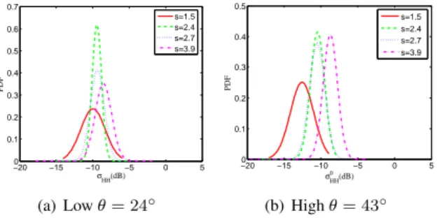
In the same way, four surface roughness status are selected for the RADARSAT-2 study, considering the roughness levels we used in the GB-SAR PoSAR experi-ment. The discriminations of four roughness status using RADARSAT-2 data at low incidence angle and high in-cidence angle are shown in Figure 7, also indicating that the four roughness fields are easier to be separated at high incidence angle.
However, we have to notice that the soil moisture is dif-ferent between the GB-SAR PoSAR experiments and the RADARSAT-2 datasets. Nevertheless, this soil moisture difference does not affect the roughness discrimination ability at high incidence angle (backscattering coefficient is dominated by surface roughness). Thus, the behaviors of GB-SAR PoSAR experiment and RADARSAT-2 data are in accordance with each other, and also agree with the conclusions in [12].
−200 −15 −10 −5 0 5 0.1 0.2 0.3 0.4 0.5 0.6 0.7 σHH(dB) PDF s=1.5 s=2.4 s=2.7 s=3.9 (a) Low θ = 24◦ −20 −15 −10 −5 0 5 0 0.1 0.2 0.3 0.4 0.5 σ0 HH(dB) PDF s=1.5 s=2.4 s=2.7 s=3.9 (b) High θ = 43◦
Figure 7: Corresponding four surface roughness dis-criminations based on RADARSAT-2 data (soil moisture around 15%).
Besides the backscattering coefficient, the polarimetric parameter is also used to discriminate different soil status. Based on the difference between double and volume scat-tering power, a polarimetric parameter DERD is defined in [13] to characterize the surface roughness. It is shown in Figure 8 the separation among four roughness status using GB-SAR and RADARSAT-2 measurements. The DERD decreases with surface roughness in two cases, and the GB-SAR data is more robust to discriminate the surface roughness. −1 −0.5 0 0.5 1 0 1 2 3 4 5 DERD PDF Original s=1.6cm s=2.5cm s=3.4cm (a) GB-SAR −1 −0.5 0 0.5 1 0 1 2 3 4 5 DERD PDF s=1.5 s=2.4 s=2.7 s=3.9 (b) RS2
Figure 8: Polarimetric parameter DERD comparison.
4
Conclusions and perspectives
In this study, the sensitivity of GB-SAR measurement to soil characteristics are evaluated under different in-cidence angles and compared with the findings we ob-tained using RADARSAT-2 multi-angular datasets. By using the GB- SAR PoSAR system, the multi-angular po-larimetric SAR data can be obtained in a quasi-invariant soil condition, which is an indispensable assumption for multi-angular inversion model. Furthermore, different surface roughness and soil moisture condition can be set deliberately, which is superior to field-scale spaceborne SAR conditions. The results we obtained using our GB-SAR PoGB-SAR measurement indicate that at higher inci-dence angle, the backscattering signature is more dom-inated by surface roughness. The polarimetric parame-ter (such as DERD [13]) has the potential to discrimi-nate roughness at high incidence angle. This angular re-sponse pattern in GB-SAR PoSAR measurements is in accordance with RADARSAT-2 datasets.
References
[1] M. Zribi and M. Dechambre, “A new empirical model to retrieve soil moisture and roughness from C-band radar data,” Remote Sens. Environ., vol. 84, pp. 42–52, 2002.
[2] B. Molineaux, A. Chanzy, and M. Zribi, “Using multi-angular radar data to discriminate the influ-ence of rough surface scattering on soil moisture in-versions over bare soils,” in IGARSS, 1999. [3] M. M. Rahman, M. S. Moran, D. Thoma, and
al., “Mapping surface roughness and soil moisture using multi-angle radar imagery without ancillary data,” Remote Sens. Environ., vol. 112, no. 2, pp. 391 – 402, 2008.
[4] L. Ferro-Famil, C. Leconte, F. Boutet, X.-V. Phan, M. Gay, and Y. Durand, “Posar: A vhr tomographic gb-sar system application to snow cover 3-d imag-ing at x and ku bands,” in Radar Conference (Eu-RAD), 2012 9th European, 31 2012-nov. 2 2012, pp. 130 –133.
[5] S. Saleh, “Soil roughness measurements:chain method,” J. Soil Water Conserv., vol. 48, pp. 527– 529, 1993.
[6] J. E. Gilley and E. R. Kottwitz, “Random roughness assessment by the pin and chain method,” Appl Eng Agric, vol. 12, pp. 39–43, 1995.
[7] S. D. Merrill, C. Huang, T. M. Zobeck, and D. L. Tanaka, “Use of chain set for scale-sensitive and erosion-relevant measurements of soil surface roughness,” in 10 th International soil conservation organization meeting, 1999.
[8] H. Wang, S. Allain, S. Méric, and E. Pottier, “Soil moisture characterization using multi-angular po-larimetric Radarsat-2 datasets,” in 4th ESA Living Planet Symposium, 2013.
[9] I. Cumming and F. Wong, Digital processing of syn-thetic aperture radar data. Artech house, 2005. [10] T. L. Ainsworth, L. Ferro-Famil, and J. S. Lee,
“Ori-entation angle preserving a posteriori polarimetcal-ibration SAR calpolarimetcal-ibration,” IEEE Trans. Geosci. Re-mote Sensing, vol. 44, pp. 994–1003, 2006. [11] J. Van Zyl, “Calibration of polarimetric radar
im-ages using only image parameters and trihedral cor-ner reflector responses,” IEEE Trans. Geosci. Re-mote Sensing, vol. 28, no. 3, pp. 337–348, 1990. [12] J. R. Adams, A. A. Berg, H. McNairn, and A.
Mer-zouki, “Sensitivity of C-band SAR polarimetric variables to unvegetated agricultural fields,” Can. J. Remote Sens., vol. 39, no. 01, pp. 1–16, 2013. [13] S. Allain, L. Ferro-Famil, and E. Pottier, “Two
novel surface model based inversion algorithms us-ing multi-frequency polsar data,” in IGARSS, 2004.