COMMUNAUTE FRANCAISE DE BELGIQUE ACADEMIE UNIVERSITAIRE WALLONIE-EUROPE UNIVERSITE DE LIEGE – GEMBLOUX AGRO-BIO TECH
USEFULNESS AND USE OF THE SOIL MAP OF RWANDA: SCIENTIFIC AND FARMERS’ SOIL KNOWLEDGE INTEGRATION FOR EFFECTIVE PARTICIPATORY INTEGRATED
WATERSHED MANAGEMENT
Toward soil-specific and farmers’ judgmental fertilizer utilization
Pascal NSENGIMANA RUSHEMUKA
Dissertation originale présentée en vue de l’obtention du grade de docteur en sciences agronomiques et ingénierie biologique
Promoteurs: Pr. Laurent Bock
Dr. Jeremias Gasper Mowo 2014
Acknowledgements
Research work towards this thesis from September, 2008 to July 2014 and ultimately its completion, would have been impossible without substantial contribution from a number of persons and institutions whom deserve my acknowledgements.
I would like to thank the Belgian Technical Cooperation (BTC) for the award of a Postgraduate Research fellowship that provided the necessary financial support for this research until April 2012.
My distinguish Acknowledgements to Professor Laurent BOCK, Promoter and main Supervisor of this thesis: Professor Bock, this thesis would not have been possible to complete without your excellent guidance, patience and comprehension. I consider it an honor to have worked with you on this thesis and I must confess that I have learned a lot. Yet I will still need your mentorship for more to come.
Many thanks are addressed to my thesis committee members for their advices and support. I will always remember your tolerance and patience on those occasions where I was challenged to access the required preliminary data to effectively start this thesis.
It would have been very difficult to finish my dissertation without the rich comments from Dr. Gilles Colinet and Prof. Jean Chapelle the two reviewers of this thesis: dear Sirs your rich comments have been decisive for both the quality and the content of this thesis, for which I am extremely grateful.
My thanks also go to my local supervisor, Dr. J. G. MOWO, ICRAF East Africa program coordinator, for his constant advice. Dr Mowo I will always remember you linking me to various scientists whom we thought could help during my stay at ICRAF/Nairobi in February 2011.
I would also want to acknowledge Professor Jean Jacques M. MBONIGABA, Director General of Rwanda Agriculture Board (RAB), my institution, to have introduced me to Dr. Gadi GUMISIRIZA for the English editing of this thesis. Professor MBONIGABA I also remember that it was from the consultancy work in which you associated me when you were still working with the National University of Rwanda in 2008 and that have brought us all around the country, that I had the opportunity to get more familiarized with the Rwanda soils in different Agro-ecological zones. It is during this study that I was fixed on the study site.
My acknowledgements are also addressed to Dr. Gadi GUMISIRIZA, RAB senior scientist –cereal breeding, for his time and energy availed to edit the last version of this thesis despite his many other duties.
I am grateful to the entire staff and PhD students of the Soil Science department of the University of Liège, Gembloux Agro-Bio Tech for their technical support and friendship.
I am also thankful for the farmers in the study area for their full cooperation to this study. My friends farmers your knowledge contribution has helped my research.
I would also like to thank the entire MVUNABANDI family in general, which invested a lot in my education but was inconvenienced by my absence in one way or another, in particular my parents MVUNABANDI Dismas and NYIRABINENWA Vénérande for their acceptance of my stay very far away from them, at a time when I should have been closer as they became more frail with age.
Last but not least, special thanks are addressed to my three sons: RUSHEMUKA N. Maxime, RUSHEMUKA Emile and RUSHEMUKA Serge, who always supported me and encouraged me with their best wishes. My sons, the suspense is now over.
Any errors or inadequacies that may have remained in this work are entirely my responsibility.
Pascal N. RUSHEMUKA 11th July 2014.
Acronyms
AEZ: Agro-Ecological Zone
AFSIS: African Soil Information Service AHI: African Highlands Initiative
ANOVA: Analysis of variance
ASARECA: Association for Strengthening Agricultural Research in Eastern and Central Africa CEC: Cation Exchange Capacity
CGIAR: Consultative Group for International Agricultural Research CPR: Carte Pédologique du Rwanda
EA: Ecological Agriculture
EDPRS: Economic Development and Poverty Reduction Strategy FAO: Food and Agriculture Organization
FSK: Farmers’ Soil Knowledge
FSRP: Farming Systems Research Program FYM: Farmyard Manure
GDP: Gross Domestic Product GIS: Geographic Information System GR: Green Revolution
IA: Industrial Agriculture
IFAD: International Funds for Agricultural Development
INEAC : Institut National pour l’Etude Agronomique du Congo belge ISAE : Institut Supérieur d’Agriculture et d’Elevage
ISAR: Institut des Sciences Agronomiques du Rwanda ISFM: Integrated Soil Fertility Management
ISNAR: International Service for National Agricultural Research ISRIC: International Soil Reference and Information Centre IUSS: International Union of Soil Sciences
MINAGRI: Ministry of Agriculture and Animal Resources MINECOFIN: Ministry of Economics and Finances MONAGRIS: Moniteurs Agricoles
NARS: National Agriculture Research Systems NGOs: Non Governmental Organizations NRM: Natural Resource Management NUR: National University of Rwanda PAP: Projet Agro-Pastoral
PR: Participatory Research PR: Pedological Region
PRA: Participatory Rural Appraisal R&D: Research and Development RA: Reference Area
RAB: Rwanda Agriculture Board
RCBD: Randomized Complete Block Design RSRS: Regional Soil Reference System SFI:Soil Fertility Initiative
SOTER: Soil Terrain Database
SPPI: Science-Policy-Practice Interface SSA: Sub-Saharan Africa
USAID: United States Agency for International Development USDA: United States Department of Agriculture
Abstract
Rwanda has a digital land resource database including a medium scale - 1:50,000 - soil map (CPR: for Carte Pédologique du Rwanda). The availability of this land resource information was expected to improve significantly the way agricultural research and extension were conducted in this country. Paradoxically, research and extension programs are still planned and implemented under a kind of trial and error approach (Multi-Environment Trials) within large and heterogeneous Agro-Ecological Zones (AEZs) without systematic consideration of different soil types within each AEZ. Overlooking the use of the CPR in this process has detrimental consequences on the overall reasoning of agricultural research and extension on the one hand, and the interpretation and extrapolation of obtained research results on the other hand. Without a broader understanding of the national biophysical environment and the systematic consideration of different soil types at watershed level it remains an illusion to expect from scientists, the development of soil-specific and transposable technologies in the complex soilscapes of Rwanda! A study was undertaken to understand how the CPR can be at the heart for Rwandan agricultural research and extension thinking towards the Science-Policy-Practice Interface (SPPI). Findings from this study show that in a country like Rwanda where the innovation model is intended to be the Participatory Integrated Watershed Management (PIWM), and where agriculture is practiced by small-scale farmers (0.5-1 ha) with an already functional Farmers’ Soil Knowledge system (FSK), the usefulness and use of the CPR can be significantly improved by integration of the scientific and FSK systems through communication bridges. The communication bridges allow scientists to interpret the farmers’ soil-related practice rationality and to introduce new soil-related technologies as compatible pieces of the FSK system.
In the Akavuguto watershed case study, the link between scientific and FSK consisted of the equivalency between scientific and farmers’ land units and scientific and farmers’ soil types. It has been observed that soils are distributed along the slope and that top soil properties and crop yields are more influenced by soil type intrinsic properties than by the land use. In other words, in the low input system of Rwanda, the response to the human management factor depends first of all on the fertility potential of each soil type. The soils of Entisols order (Urubuye /Urusenyi) occupy the mountainous and crests/interfluves. The soils of Ultisols order (Inombe) occupy the plateaus and shoulders. The soils of Oxisols order (Umuyugu/Mugugu) occupy the hillsides/back slopes (the largest land unit); while the soils of Histosols order (Nyiramugengeri) occupy the valleys. Except the mountainous which are constrained by the steep slopes (gradient >55%), soils with good soil properties (slightly acid and less leached) are located in the upper hill made up by hill summits, crests, plateaus and shoulders. In these land units, soils can still produce relatively good crop yields under low farmers’ input system (farmyard manure). The infertile soils (extremely acid and strongly leached) occupy hillsides. To produce good staple crop yields, these soils imperatively need the combination of lime, organic manure and fertilizers. Other infertile soils (extremely acid) are found in the valley bottom. The soils
in this land unit need the combination of lime and fertilizers to be productive. Thus, the integration of CPR soil resource information with the FSK system improves the accessibility of scientific soil knowledge and constitutes an effective way of achieving soil-specific technologies and a practical way of extrapolating results to analogous soil types. The most important practical implication is that the representative regional soil reference systems integrating both scientific and FSK systems at watershed level and circumscribed in the landscape context constitutes a key step towards an –ease-to-use Land Information System (LandIS) for Rwanda. The user friendly LandIS is necessary for the sound management of the Rwandan space and for more rational agronomic experimentation. The main policy implication is that the Participatory Integrated Watershed Management should be institutionalized in agricultural research and development organizations as a valid and valuable innovation model to which policy, administration and finance institutions should adapt.
Résumé
Le Rwanda possède une carte des sols (CPR : pour Carte Pédologique du Rwanda) numérique à moyenne échelle - 1/50.000 - et sa base de données. Il était espéré que l’existence de cette carte aide à améliorer significativement la façon dont étaient conduites la recherche et la vulgarisation agricoles dans ce pays. Paradoxalement, la recherche et la vulgarisation continuent d’être planifiées et exécutées dans une sorte d’essais et d’erreurs (Essais-Multi-locaux), sur base de Zones Agro-Ecologiques (ZAE) vastes et hétérogènes et cela sans considérations systématiques des différents types des sols dans chaque ZAE. La non prise en compte de la CPR a bien évidemment des conséquences néfastes sur la philosophie et l’organisation générale de la recherche et de la vulgarisation d’une part, et sur l’interprétation et l’extrapolation des résultats obtenus d’autre part. Sans compréhension intégrale du milieu biophysique à l’échelle nationale et sans prise en compte systématique des différents types de sols à l’échelle du bassin versant, il restera certainement illusoire d’escompter, de la part de chercheurs, le développement des technologies pertinentes, efficientes et transposables! Une étude a été menée en vue de comprendre comment la CPR peut être au cœur de la philosophie de la recherche et de la vulgarisation agricoles du Rwanda vers une interface science-politique-pratique fonctionnelle. Cette thèse montre que, dans un pays comme le Rwanda où le modèle d’innovation se veut la Gestion Participative et Intégrée des Bassins Versants et où l’agriculture est pratiquée par les petits paysans (0.5-1 ha) avec une connaissance profonde de leurs sols, l’utilisation de la CPR peut être améliorée par l’intégration des connaissances des sols définies scientifiquement et celles reconnues par les paysans. Cette intégration passe par l’intermédiaire de liens de communication entre les deux systèmes de connaissance. Ces liens améliorent le flux d’information et permettent d’ancrer l’intervention scientifique dans la connaissance pédologique paysanne.
Dans le bassin versant de l’Akavuguto, ces ponts de communication ont consisté à faire l’équivalence entre (1) les unités paysagiques définies scientifiquement et celles appréhendées au niveau paysan (2) le type de sol identifié au sens pédologique et le type de sol reconnu par le paysan. Il a été observé que les sols, au niveau du bassin versant, sont regroupés en associations selon les unités géomorphologiques et que les propriétés de sols des échantillons de surface ainsi que les rendements de cultures sont beaucoup plus influencés par les propriétés intrinsèques de chaque sol que par le type d’utilisation des terres. En d’autres termes, dans le système de faible taux d’utilisation d’intrant longtemps pratiqué au Rwanda, la réponse au facteur ‘gestion par l’homme’ est avant tout fonction du potentiel de fertilité de chaque sol. Les sols de l’ordre des Entisols (Urubuye/Urusenyi) occupent les massifs montagneux et les crêtes/interfluves. Les sols de l’ordre des Ultisols (Inombe) occupent les plateaux. Les sols de l’ordre des Oxisols (Umuyugu/Mugugu) occupent les versants, tandis que ceux de l’ordre des Histosols (Nyiramugengeri) occupent les vallées humides. Exception faite pour les massifs montagneux qui sont limités par les fortes pentes (>55%), les sols relativement fertiles (légèrement acides et moins lixiviés) se trouvent dans la partie sommitale constituée de sommets de collines, de
crêtes et de plateaux. Les sols dans ces unités géomorphologiques peuvent encore produire de bonnes récoltes sous le système paysan d’intrants, composé essentiellement de fumier de ferme ou de compost. Les sols infertiles (extrêmement acides et fortement lixiviés) occupent les versants. Pour avoir de bonnes récoltes, ces sols exigent la combinaison de chaux, de fumure organique et de fertilisants inorganiques. Une autre catégorie de sols infertiles occupe les vallées. Les sols dans cette unité paysagique exigent la combinaison de chaux et de fertilisant inorganique pour être productifs. La conclusion principale est que l’intégration de l’information pédologique offerte par la CPR avec la connaissance pédologique paysanne constitue un moyen de mener les interventions adaptées à chaque type de sols et une modalité pratique de transférer les technologies sur les sols analogues.
L’implication pratique la plus importante est que le système régional et représentatif de références sur les sols intégrant la connaissance scientifique et celle paysanne et circonscrit dans leur contexte géomorphologique constitue, pour le Rwanda, une étape clé vers un système d’information sur le sol (LandIS) plus accessible à l’échelle d’un bassin versant. Un LandIS plus accessible est nécessaire pour une gestion saine de l’espace rwandais ainsi que pour une expérimentation agronomique plus rationnelle. La principale implication politique est que l’approche par Gestion Participative et Intégrée des Bassin Versants devrait être officialisée, dans les institutions de recherche et de développement, comme modèle d’innovation valide et valable auquel les institutions politiques financières et administratives devraient s’adapter.
Table of contents
Acknowledgements ... ii
Acronyms ... iv
Abstract ... vi
Résumé ... viii
Table of contents ... x
Chapter I: General introduction ... 1
1.1 Problem statement ... 1
1.2 Justification to the problem ... 6
1.3 Research question ... 7
1.4 Hypothesis ... 7
1.5 Objectives ... 8
1.5.1 Overall objective ... 8
1.5.2 Specific objectives ... 8
1.6 Methodological approach overview ... 8
1.6.1 Biophysical milieu description ... 8
1.6.2 Population pressure and land use ... 12
1.6.3 Site selection process ... 13
1.6.4 Study area description ... 16
1.7 Thesis outline ... 18
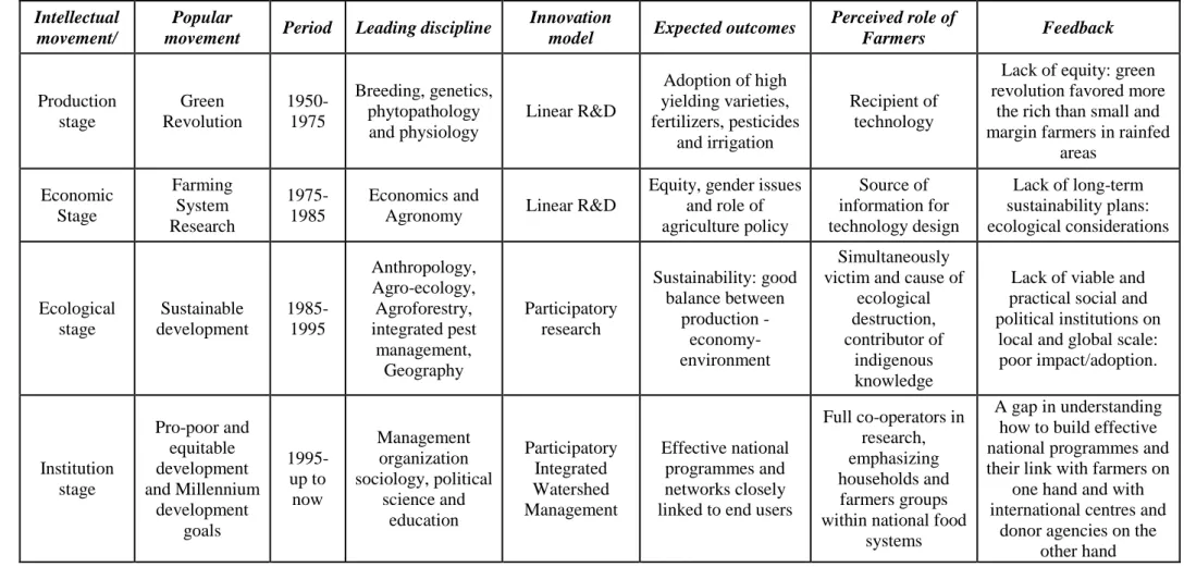
Chapter II: Agricultural research and extension in Rwanda: evolution of concepts and the
need for capturing the soil factor ... 20
2.1 Introduction ... 20
2.2 Brief historical background ... 22
2.3 Evolution of research approaches and development concepts ... 24
2.3.1 The linear Research & Development model ... 24
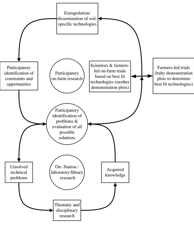
2.3.2 On-Farm Research ... 27
2.3.3 Participatory Integrated Watershed Management approach ... 29
2.3.4 Mother-baby approach ... 32
2.4 Some identified challenges to the PIWM ... 33
2.5 Discussion ... 34
2 5.1 The PIWM bottleneck ... 34
2.5.2 Toward effective PIWM ... 38
2.6 Conclusion ... 40
Chapter III: Soil science and agricultural development in Rwanda: The state of the art ... 41
3.1 Introduction ... 41
3.2 Methodological approach ... 42
3.3 Soil science components and achievements in Rwanda ... 43
3.3.1 Soil survey ... 43
3.3.2 Soil conservation and erosion control ... 44
3.3.3 Soil fertility management ... 47
3.4 Discussion ... 52
3.4.1 Soil survey, soil conservation and soil fertility management ... 52
3.4.2 Ecological versus Industrial agriculture ... 53
3.5 Conclusion ... 59
Chapter IV: Farmers’ soil Knowledge for Effective Participatory Integrated Watershed
Management in Rwanda: towards soil-specific fertility management and farmers’
judgmental fertilizer use. ... 60
4.1 Introduction ... 60
4.2 Methodology ... 62
4.2.1 Participants selection process ... 63
4.2.2 Land units, soil types and soil-landscape relationship ... 63
4.2.3 Transect walks and field observation ... 64
4.3 Results ... 64
4.3.1 Farmers’ cognitive knowledge ... 64
4.3.2 Link between scientific and farmers’ soil knowledge ... 68
4.3.3 Farmers’ practices: land use and soil fertility management ... 72
4.4 Discussion ... 74
4.4.1 Farmers’ cognitive knowledge ... 74
4.4.2 Crop allocation and soil fertility management strategy ... 75
4.4.3 Coping/adaptation mechanism and livelihood strategy behind crop allocation and
soil fertility management practice ... 77
4.4.4 Practical lessons learnt ... 78
4.5 Conclusion ... 79
Chapter V: Soil Reference System and soil properties interpretation in Rwanda: Akavuguto
watershed case study ... 80
5.1 Introduction ... 80
5.2 Methodological approach ... 84
5.2.1 Transect walks and field observation ... 84
5.2.2 Composite soil samples ... 84
5.2.3 Laboratory soil property analysis ... 85
5.3 Results ... 85
5.3.1 The main soil types of the study site ... 85
5.3.2 Soil properties of the main soil types ... 96
5.3.3 Land use: composite soil samples ... 96
5.3.4 Regional Soils Reference System ... 96
5.4 Discussion ... 103
5.5 Conclusion ... 107
Chapter VI: Strategic soil fertility management for replicable technologies development in
Rwanda ... 108
6.1 Introduction ... 108
6.2 Methodological approach ... 109
6.2.1. Soil sampling strategy ... 109
6. 2. 2 Matching soil types and appropriate inputs. ... 110
6.3 Results ... 112
6.3.1 Sorghum biomass experiment results ... 112
6.3.2 Effect of lime on soil properties ... 117
6.4 Discussion ... 119
Chapter VII: General conclusion ... 124
7.1 Conclusion ... 124
7.2. Practical implications ... 126
7.3 Policy implications ... 127
7.4 Further Research ... 128
References ... 130
Chapter I: General introduction
1.1 Problem statement
Rwanda is subdivided into different and sometimes spatially overlapping Agro-Ecological Zones (AEZs) (Delepierre, 1974; Prioul and Sirven, 1981; Gasana, 1990; Verdoodt and Van Ranst, 2003a). These natural regions are well covered by a ‘representative’ network of experimental research stations (ISNAR, 1982). However, syntheses of 30 years (1960-1990) of agricultural research in crop fertilization and crop variety selection (Rutunga, 1991) and 15 years (1980-1995) of green manuring and improved fallow (Drechsel et al., 1996) show that many trials undertaken in different sites (on station or on-farm trials) within one AEZ and between different AEZs (Multi-Environment Trials), yielded inconsistent and most of the time, contradictory results when it comes to synthesize and extrapolate results over the entire AEZ. Indeed, given the variations of soil types and their characteristics over short distances and in complex manner common in the mountain landscapes of Rwanda, the soil types and soil parameters vary significantly within AEZ as they do between AEZs (Birasa et al., 1990; Steiner, 1998). Therefore, many studies undertaken under the conventional research approach were not soil-specific1: hence the contradictory results.
On the other hand, because of small-scale variations of soil types in mountain agriculture, soil suitability maps for the entire AEZs (1:250,000) (Verdoodt and Van Ranst, 2003a) have been rendered irrelevant for farmers and the Agro-Ecological Zone-based crop regionalization and specialization have not yet been adopted (Steiner, 1998). Consequently, the medium scale soil map of Rwanda -1.50, 000- (CPR: for Carte Pédologique du Rwanda) (Birasa et al., 1990), which was expected to be the foundation of the Rwandan agriculture transformation reasoning has since its completion been a
sleeping beauty.
A quick analysis on the use of the CPR suggests that the little exploitation of this soil map in agricultural research and extension could be a communication issue in terms of level of perception (scale) and legend (Soil Taxonomy and pedogenetic legends). It is true that these factors are considerable constraints for many soil map potential users, especially in Rwanda where the soilscape is very complex on the one hand, and where there is little experience of the use of soil maps on the other hand (Steiner, 1998). However, these are not enough to explain all problems that undermine the use of soil maps in agriculture research and extension.
1
Soil-specific refers to the fact that the soil on which the intervention is undertaken should be well known in terms of its name and spatial distribution and characterized in terms of its properties so that the results obtained are transposable to analogous soil types in other areas. The spatial distribution of the analogous soil types should be known in the planning area. In other words, the soil-related interventions should systematically take into account different soil types at watershed level within each AEZ.
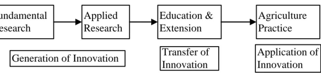
A deep analysis shows, however, that the most acute problem with the use of soil maps begins with a policy misconception that has institutionalized the linear model of innovation2 with its compartmentalized research based on academic disciplines and crop commodities (Bock, 19943; Leeuwis and van de Ban, 2004; Raina et al., 2006). The above mentioned model postulates that innovation starts with basic research, followed by applied research and development, and ends with production and diffusion (Leeuwis and van den Ban, 2004; Godin, 2005). In the context of this model, the overwhelming majority of the soil map potential users do not know (are not aware) that they need the soil map! This lack of awareness is a big problem, because it prevents the necessary positive attitude towards the soil resource information. Indeed, soil maps are produced by soil surveyors for non-soil survey specialist potential users (Dent and Young, 1981). However, many soil maps potential users maintain that they do not understand how they can use them for their own application (Bui, 2004). In these conditions, it becomes clear that the first fundamental problem in using soil maps in agricultural research and development is the fact that those who should be working with them seldom understand the logic of their use whether they are detailed or not, with technical or utilitarian classification systems (Wielemaker et al., 2001; Niemeijer and Mazzucato, 2003; Bui, 2004).
A second fundamental problem about the use of many soil maps is the fact that the landscape context in which soils occur, which helps to form the soil surveyor mental model is not represented as part of the final soil map legend (Wielemaker et al., 2001; Omuto et al., 2013). The information lost by not representing the landscape context in which soils occur hampers the capacity of soil surveyors to fully communicate the soil resource information so that the soil surveyor mental model is clear for all potential users (Wielemaker et al., 2001). Indeed, there are traditionally two mapping approaches in soil survey: the pedological approach and the physiographic or geomorphological approach. In the pedological approach (soil-centred approach), maps and legends present only soil information. Soil-landscape relations are usually described only for representative profiles in the report/booklets. In the physiographic/geomorphological approach, soils are mapped as part of the landscape (Figure 1.1). In this approach, high categories of map legends are expressed in geomorphological terms. Lower categories are often landscape components in which the soils are described as patterns or associations. Examples of such soil maps are the Australian Atlas soil map units (Bui, 2004) and the Soil Terrain (SOTER) model of the International Soil Reference and Information Centre (ISRIC). Although in both mapping approaches landscape is used to delineate soil mapping units, the pedological map legends do not usually provide information on the landscape context (Wielemaker et al., 2001). Much useful information can still also be retrieved from the soil-centered soil maps and much application can be
2
This model is called ‘the linear model of innovation’ because it draws a straight and one directional line between various actors (see Chapter 2, Figure 2.1). In this model some actors are supposed to specialize in the generation of innovations, other concentrate on their transfer, while the farmers’ role is merely to apply innovations (Leeuwis and van den Ban, 2004).
3 Bock (1994) observed that ‘le cloisonnement des structures éloigne le chercheur du praticien’ ainsi que le
deduced from them, but only by users who understand how soil maps are done (Bui, 2004). Thus, the pedological map (two dimensions), is more directed to a peer audience of other soil survey specialists rather than to a large group of its potential users (Wielemaker et al., 2001).
Figure 1.1 An example of a land system approach with nested multi-scale objects of the land unit hierarchy with an illustration of the desegregation and classification procedure zooming (white
coloured units). Source: (Wielemaker et al., 2001).
The presented case study (Figure 1.1) has five levels: the region, the major land form, the landform element, the facet and the site or pedon. Each level has its scale range. The levels are grouped into three subsystems: the region subsystem, the geomorphological subsystem and the soilscape subsystem. The levels in this case study were clearly defined. In our case, the different hierarchies are the national territory, Agro-ecological zone/Pedological region, watershed, benchmark, land unit and soil type (see Figures 1.5a, b; 1. 8).
The CPR is a soil-centered soil map. Its digitized database and its report (booklets) show three types of legends: the cartographic4, the narrative and the taxonomic legends. The hard copy (printed version) of the CPR shows only the narrative legend. In the three types of legends, the landscape context in which
4 Cartographic legend is made up by a set of symbols used by the soil surveyor at field level to record soil profile characteristics. It is a basis for pedogenetic narrative legend: a soil forming factor-oriented legend. The taxonomic legend is a soil classification-oriented legend. Soil Taxonomic is itself a pedogenetic soil classification system.
soils occur is not explicitly represented as part of the soil map legends. This is only done in the soil map report (booklets/”notice explicatives”). The problem with the soil map reports is that they are considered too academic, too riddled with incomprehensible jargon or too remote from the practical decision and action which are needed for successful development and management of agriculture enterprises (Landon, 1991). The fact that the landscape context in which the soils occur is not explicitly incorporated in the final soil map legend together with the inaccessible international soil classification systems hamper the capacity of non-soil surveyor to capture the soil surveyor mental model (Wielemaker et al., 2001; Bui, 2004). Hence the persistence of the idea that soil maps are not efficient communication tools (Hudson, 1992 cited by Bui, 2004). The consequence is that the many potential users of the soil maps merely overlook them and plan their actions without systematic consideration of different soil types within each AEZ (Nachtergael., 2000; Raina et al., 2006). The penalties of this situation are many: (1) persistence of the incoherent and contradictory results and the confusing extrapolation framework, leading to lack of soil-specific technology recommendations (2) developers imposing improvised and generic technology recommendations – e.g. blanket fertilizer recommendation (3) inefficient allocation of the limited financial resources (4) high yield risk5 and therefore, low adoption rate of the proposed technologies (5) persistence of low productive agricultural systems and, (6) persistence of food insecurity and poverty.
In view of the above situation, it is up to soil scientists to take the leadership not only in soil fertility management but also in the set up of soil fertility management policies (Brigdes and Catizzone, 1997; Hartemink and Bouma, 2012). This means that they must work more closely with practitioners of other disciplines, and also take legal, economic and social conditions into account so that sustainable land management systems are developed and used (Brigdes and Catizzone, 1997). Because soil scientists have been less influential in the agricultural development circles at global and continental levels (Muchena, 1995; Brigdes and Catizzone, 1997; Hartemink and Bouma, 2012), scientists from other disciplines, mainly agricultural economists have been leading the international agriculture institutions like the CGIARs6 (Mackay and Horton, 2003), but with less consideration/understanding of the biophysical environment (Nachtergaele, 2000). For example, soil scientists hardly understood the fact that the soil as such was not given specific mention in the United National Conference on Environment and Development (UNCED) held in Rio de Janeiro in 1992 as an understanding of soil
5
Yield Risk is defined as the probability of obtaining yields lower than or equal to the control across similar conditions of soil, climate and management (Sileshi et al., 2010).
6
For instance, key positions, both in individual centres and in system-level bodies (such as Technical Advisory Committee, the interim Science Council, the CGIAR Secretariat and the Executive Council) have been occupied by economists, who have fostered the use of economic frameworks and quantitative methods in planning, priority setting and evaluation (Mackay and Horton, 2003). It is in this context that the CGIAR has developed a deeply rooted ‘hard-science’ culture and an unquestioning belief in the value of applying modern, positivist scientific methods to the solution of agriculture, environment and related problems. The problem is that in this context where the science is virtually synonymous of quantitative analysis, the alternative approaches such as qualitative methods, participatory approaches and constructivist logic are regarded as highly suspect – ‘soft science’- at best (Mackay and Horton, 2003).
management underlies so many declarations (Brigdes and Catizzone, 1997). Another example is that more recently and in the context of the Millennium Development Goals (MDGs), much emphasis has been placed on stimulating the use of fertilizers without critically examining where fertilizer is efficient and where it is not and why (Sileshi et al., 2010). A last example is the way that genotypes are traditionally evaluated using multi-environment/location trials without systematic consideration of different soil types in these different locations (Matthews et al., 2002). This implies that greater effort is still needed to bridge the gap of understanding between soil science and the rest of the community (Brigdes and Catizzone, 1997).
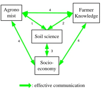
Elsewhere, in the new context of research for development, and under the influence of Chambers (1985), different international institutions that backstop the National Agricultural Research System (NARS) of developing countries have initiated more Participatory and Integrated research and development approaches. These approaches were recognized to complement the discipline-based and commodity oriented academic agricultural research and to substitute the linear and top-down technology transfer approach. In the discipline-based and top-down technology transfer, soil science and its sub disciplines constituted an independent compartment with its own sophisticated communication jargon. In the new research and development model, it is called to play a leading role and consequently, to adopt a user-friendly communication language, to guarantee maximum accessibility of the information it holds.
It is from this new research and development context that scientists realized that farmers have deep soil knowledge in their own perspective. The Farmers’ Soil Knowledge (FSK) was recognized to form a much better starting point for interactive communication than the international classification systems during the participatory integrated innovation process (Niemeijer and Mazzucato, 2003). Thus, many authors found that Rwandan farmers, like many others worldwide, possess such detailed soil knowledge that enables them to exploit any soil difference in agricultural production (Habarurema and Steiner, 1997; Steiner, 1998; Rushemuka et al., 2009). This detailed soil knowledge has been strongly recommended to be the starting point of scientific intervention in adaptive research and development (Habarurema and Steiner, 1997; Steiner, 1998). These authors advise scientists to directly build recommendations on FSK and rely on farmers’ ‘accurate and precise mental soil maps’ (Barrera-Bassols et al., 2006b) and farmers’ flexible soil nomenclature to cope with the complex soilscape of Rwanda. Despite all these works, the problem of soil-specific interventions and replicable research results is still unresolved.
In this thesis I argue that the usefulness and use of the CPR at watershed level, and in the new context of agricultural research for development, can be enhanced by explicitly representing the land units in which soils occur as part of the CPR legend and by establishing communication bridges between the scientific and FSK systems. Linking the scientific and FSK is a mean of offering an executive framework that permits the scientific interventions to be introduced as pieces of the already functional FSK system. This is very important because technologies proposed by researchers from small
experiment plots, rely on farmers to adapt them on different soil types of their own fields. The originality of this thesis is the fact that it offers effective mechanisms to build soil fertility management technologies on the synergism between the existing soil resource information database (CPR) and FSK system. In doing so, it contributes to fill the communication gap observed between those developing technologies and these being asked to use them (Niemeijer and Mazzucato, 2003). It adds value to the works of Habarurema and Steiner (1997) and Steiner (1998) who recommend the use of FSK by scientists in adaptive research and development. The FSK helps validate scientific soil knowledge to ensure that it is not only scientific but also relevant and functional (Barrera-Bassols et al., 2006b).
1.2 Justification to the problem
The new arena of agricultural research for development consisting of more participatory and integrated approach is shaped by the concept of Sustainable Development - matching human well-being and ecosystems preservation. This new research framework is complex and is likely to be achieved only by teamwork from different disciplines, cooperating within them and with farmers through interactive communication, to solve a concrete problem in a given location in an innovative way (Laker, 1981; Leeuwis and van den Ban, 2004, Weichselgartner and Kasperson, 2010). The participatory, integrated approach, though good in theory, is still difficult to implement. Hence, many authors have suspected a methodological gap or a fundamental problem which is not yet solved (Leeuwis and van den Ban, 2004; Quinlan and Scogings, 2004; Mafuka et al., 2005; German et al., 2006).
It is expected that this thesis will provide a framework to improve the collaboration between different stakeholders in the food production system. In fact, the accessibility and intelligibility of soil resource information (both scientific and FSK) will improve the interaction between (1) bio-physical disciplines among themselves, (2) the bio-physical and socio-economic disciplines and (3) the researchers - scientific community- and the farmers. The communication then established will start the re-thinking about the methodological gap and will boost the institutional reform to make the approach more effective. The renewed approach will allow the functionality of the “Science-Policy-Practice Interface” (SPPI) towards a “knowledge-action continuum” in research for development. At policy level, this thesis is expected to contribute to more biophysical environment understanding that is necessary to objectively revisit some relevant challenges and pitfalls observed in many land-related policy documents of Rwanda and their implementation (see Ansoms, 2008; Pritchard, 2013) and perhaps easily and exclusively attributed to some political reasons. It is a fact that the biophysical environment (the land in its broader sense) understanding is a pre-condition to its relevant and efficient management! Currently, there is much emphasis on policy and laws as tools for shaping society without sufficient understanding of biophysical and institutional environments into which new policies and laws are to be implemented (Ansoms, 2008).
1.3 Research question
How can the soil map of Rwanda 1:50,000 effectively play its role as the foundation of agricultural research and development to allow the agriculture sector to be really, an engine of the country’s economic growth? The above research question can be subdivided into the following research sub questions:
1. How have the Rwandan agricultural research and development institutions and organizations evolved to cope with the innovation models that have evolved over time, and what has been the place and role of the soil resource information in this process?
2. How has soil science, as a sub-discipline of science and agriculture technology been effectively used in agricultural research and development and what has been learnt?
3. How can the scientific and the FSK be integrated for watershed level effective participatory and integrated agricultural research and development?
4. Can the scientific-farmer soil type based Regional Soil Reference System (RSRS)7 help to analyze and interpret soil properties and soil-related experimental results to ensure soil-specific interventions and replicable technologies?
5. Can the farmers’ soil nomenclature be a useful communication language in agricultural research and development to cope with short distance variability of the soils of Rwanda?
1.4 Hypothesis
The usefulness and use of medium scale soil map of Rwanda, at watershed level and in participatory and integrated research approach, can be enhanced by explicit representation of the landscape context in which soils occur as part of the soil map legend and by the integration of the scientific and FSK. This hypothesis can be subdivided into 5 sub-hypotheses:
1. The usefulness and use of the soil map depend on the research and development approach/innovation model adopted within a country: the more integrated the research and the more interactive the extension, the more useful the soil map becomes.
2. The impact of soil science, as a sub-discipline of science and technology, to the country’s development is more a matter of the adopted research and development approach and the existing institutions and their capacity to allow the necessary interaction among its own sub-disciplines on one hand, and its sub-disciplines and other disciplines on the other hand; in other words, the impact of soil science depends on conducive research and development context within a given country.
3. Linking scientific and FSK might be an appropriate way of getting advantages from the two knowledge systems and is likely to contribute significantly to the effectiveness of the Participatory Integrated Watershed Management (PIWM).
7 A RSRS can be defined as a multi-hierarchical land information system where a set of geo-referenced representative soil profiles and land use suitability are described, in relation to the soil forming factors and the soil-landscape relationship in precise geographic scope (for more detail, see chapter V).
4. The RSRS is an appropriate way to understand, interpret and monitor soil properties and is likely to ensure soil-specific interventions and replicable experiment results.
5. The farmer soil nomenclature is rational and can be used in agriculture research and extension to enhance communication between scientists and farmers.
1.5 Objectives
1.5.1 Overall objectiveThe overall objective of this thesis is to contribute to the effectiveness of the Participatory Integrated Watershed Management (PIWM) approach by highlighting the central role of the soil resource information in this process.
1.5.2 Specific objectives
The specific objective is to demonstrate how the CPR can be used as the foundation of small scale farmers’ technology development like soil-specific fertilizer use. This objective can be subdivided in 5 sub-objectives.
1. To discuss the conceptual framework in which the soil map of Rwanda is expected to be used in agricultural research and extension of this country.
2 To identify and capitalize on positive lessons learnt from many years of soil science interventions in agricultural research and extension in Rwanda.
3. To improve the capacity of scientists to capture the farmers’ rationality by linking the scientific and FSK systems at watershed level.
4. To set up a regional soil reference system as a mean of overtime interpreting, monitoring and evaluating soil properties and crop yields.
5. To demonstrate how the farmer soil nomenclature can be used in agricultural research and extension to achieve soil-specific soil fertility management recommendations.
1.6 Methodological approach overview
1.6.1 Biophysical milieu descriptionRwanda is a small (26 000 km2) and a landlocked country isolated in Central Africa over more that 1000 Km from the Indian ocean and 2000 Km from the Atlantic Ocean (Roose et al., 1993). Its neighbors are Uganda in north, Tanzania in east, Burundi in south and Democratic Republic of Congo in west. This highland and hilly country lies between 1°4’ and 2°51’ of southern latitude and between 23°53’ and 30°53’ of eastern longitude. Figure 1.2 shows that altitude ranges from 923 m (plain of Bugarama in South-West) to 2,800 m with some peak at 4,507 m (top of Volcano Mountains in the North-West). Because of the high altitude, this equatorial country is characterized by a sub-equatorial climate. Mean temperature is relatively stable during the year, and ranges between 15 and 25°C (Verdoodt and Van Ranst, 2003a).
Figure 1.2 Rwanda Digital Elevation Model. Source: Centre GIS of the National university of Rwanda.
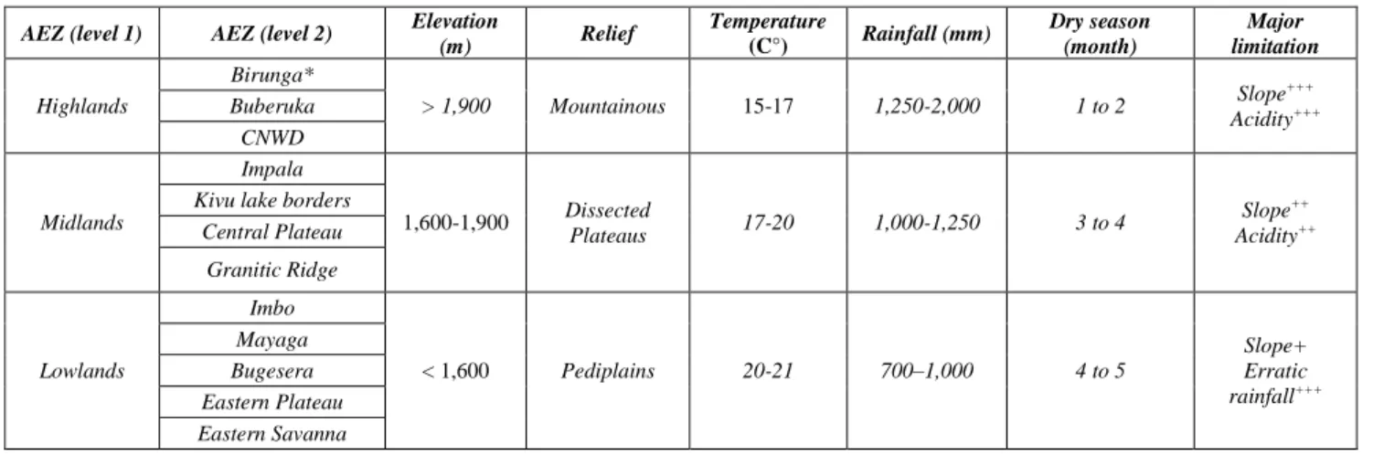
From East to West, rainfall regimes vary from semi-humid to humid, with a bimodal rainfall regime. On the basis of relief, elevation and climate, a first perception allows subdividing the country into three agro-ecological zones (AEZs) most known as altitudinal zones: highlands, midlands and lowlands (Van Wambekeke, 1963; ISNAR, 1982, Verdoodt and Van Ranst, 2003a). The highlands, midlands and lowlands occupy 17, 32 and 38% of the territory respectively (Verdoodt and Van Ranst, 2003a). The remaining 14% are constituted by escarpment (1%) and marshes, islands and lakes (13%) (Verdoodt and Van Ranst, 2003a). The main common features in this first level of perception of AEZs are presented in Table 1.1.
Table 1.1 First level of AEZs perception, climatic characteristics and major limitations.
AEZ (level 1) AEZ (level 2) Elevation
(m) Relief Temperature (C°) Rainfall (mm) Dry season (month) Major limitation Highlands Birunga* > 1,900 Mountainous 15-17 1,250-2,000 1 to 2 Slope +++ Acidity+++ Buberuka CNWD Midlands Impala 1,600-1,900 Dissected Plateaus 17-20 1,000-1,250 3 to 4 Slope++ Acidity++
Kivu lake borders Central Plateau Granitic Ridge Lowlands Imbo < 1,600 Pediplains 20-21 700–1,000 4 to 5 Slope+ Erratic rainfall+++ Mayaga Bugesera Eastern Plateau Eastern Savanna
+++: high, ++: medium, +: low limitation; CNWD: Congo-Nile Watershed Divide; * note: The Birunga (Volcanic) AEZ is not limited by acidity and the relief is generally less
mountainous compared to other AEZs in the Highlands.
This generalization does not consider the volcanic mountains that culminate at 4507 m of elevation. Source: synthesized from different sources by the author of this thesis.
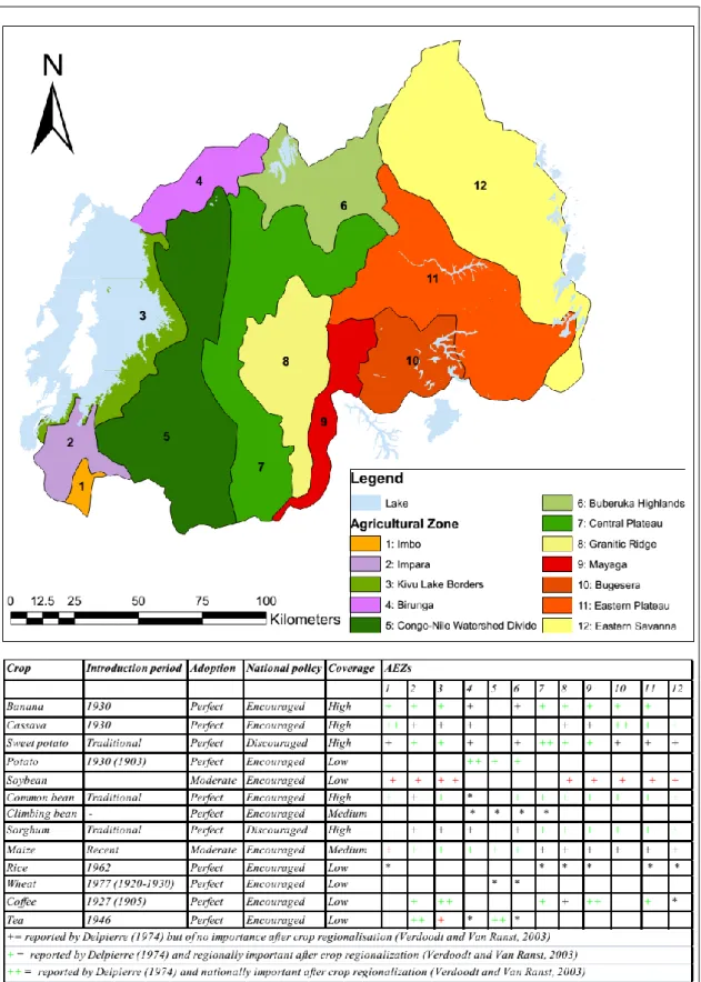
At a second level of perception, the three AEZs were empirically subdivided into 12 natural regions known as agricultural zones (Delepierre, 1974) (Figure 1.3). They were later refined into 18 AEZ (Gasana, 1990). The diversity in climatic conditions allows an important diversification from crops suited for tropical areas to crop adapted to temperate climatic conditions (Figure 1.3).
From a pedological point of view, the experience of soil science team of the “Institut des Sciences Agronomiques du Rwanda” (ISAR), working since 1955, was synthesized into a soil association map of 18 Pedological Regions (PR) (Prioul and Sirven, 1981) (Figure 1.4). In general, soil fertility declines as one climbs up in altitude except for the highland volcanic AEZ. A closer examination of the soil map of Rwanda, established by the project ‘Carte Pédologique du Rwanda’ (Birasa et al., 1990), shows extreme variability of Rwanda soils within one AEZ or one PR. At watershed level, soil parameters change in a characteristic way from the hilltop/upper slope to the lower slope and valley bottom (Steiner, 1998).
Figure 1.3 Agro-Ecological Zones of Rwanda and related suitable crops. Source adapted from Delepierre (1974) and Verdoodt and Van Ranst (2003a).
0 24,50049,000 98,000 147,000 196,000 Km
.
Legend
Lake Kivu
Association à Andepts sur cendrées grossières, Lithosols sur laves, Histosols dans les vallées Association à Andosols sur cendrées fines, Andepts sur cendrées grossières, Lithosols sur laves Association à Sols bruns de cendrées volcaniques, Ferrisols humifères, Histosols enrichis Association à Ferrisols et Ferralsols humifères sur basalte, Histosols de vallées Association à Umbrepts forestiers et tourbières
Association à Umbrepts désaturés des prairies d'altitude
Association à Ferrisols humifères intergrades sols recents sur schistes et phyllades, Lithosols sur crêtes Association à Lithosols sur crêtes, Ferrisols humifères intergrades sols recents sur schistes et phyllades Association à Ferrisols intergrades Sols recents et Collivions de concavite sur granite
Association à Lithosols sur crêtes quartzitiques et Ferrisols intergrades Sols recents de bas versants
Association à Ferralsols de glacis et Ferrisols de crêtes Association à Ferralsols de collines, Histosols de vallées Association à Ferralsols sur intercalations basiques Associations à Xeroferralsols a pan, Cortisols dans les vallées Associations à Xeroferralsols de pentes, Vertisols de vallées
Associations à Xeroferralsols orthotypes, lithosols de crêtes, Vertisols de vallées Histosols
Vertisols
Figure 1.4 Pedologic regions of Rwanda. Source (Prioul and Sirven, 1981).
1.6.2 Population pressure and land use
With a land size of 26,338 km2 and a population of more than 10 million, Rwanda is the most densely populated country in Africa. At an annual population growth of 3%, the Rwandan population has doubled every 20 years since the Second World War. Indeed, the Rwandan population of 1.9 million in 1948 increased to 4.8 million in 1978 and 5.5 millions in 1982 (ISNAR, 1982). After the 1990-1994 war and genocide, the last census (Xinhuanet, 2012) shows that the population has increased from 8.2 million in 2002 to 10.5 million in 2012 and that the population growth has fallen from 2.9 to 2.6
during the same period. This dramatic population growth has resulted into all the national territory being occupied and cultivated. Indeed, 86.5% of Rwandan population is constituted by rural households living from agriculture. The later sector contributes 36 % to the country’s Gross Domestic Product (GDP) (World Bank, 2010).
Historically, the first human settlements were in the hilly region (dissected plateau) of the Mid Altitudinal Zone. In this region, Rwandan farmers settled along the interfluves of their hillsides, where soils were more fertile than further down on the steeper slopes and where cultivation was easier than in the marshy valleys (Clay and Lewis, 1990). The households exploited three main ecological sites: (1) the interfluve/upper ridge (2) the hillside and (3) the valley bottom (ISNAR, 1982). On the interfluves and plateaus immediately surrounding the household compound, farmers planted groves of banana and other strategic crops like sorghum and beans. Further down on the back slope, they grew less demanding crops like sweet potato and cassava with frequent fallow periods. The steep slope beyond the sweet potato and cassava plots was reserved for pasture and woodlots. At the base of the slope and in swampy valleys, they raised sweet potato and vegetables along ridges that were built to facilitate water drainage (Clay and Lewis, 1990).
In a more recent past (sixties and seventies), Rwanda farmers exploited other areas of the country in response to population pressure (Drechsel et al., 1996). From the central plateau, they colonized the north and west which were under forest (ISNAR, 1982) and the eastern and less humid savannahs (lowlands) that were previously the domain of the pastoralist population (Verdoodt and Van Ranst, 2003a). Today, with nearly all the land occupied, farmers cultivate the same holdings year after year and in increasingly labor intensive fashion. Land scarcity has now compelled farmers all over the country to depart from their traditional system and convert unproductive pastures and woodlots into cropland and cultivate steep sloping fields and marshlands which were traditionally reserved for livestock grazing. The livestock is kept under zero grazing.
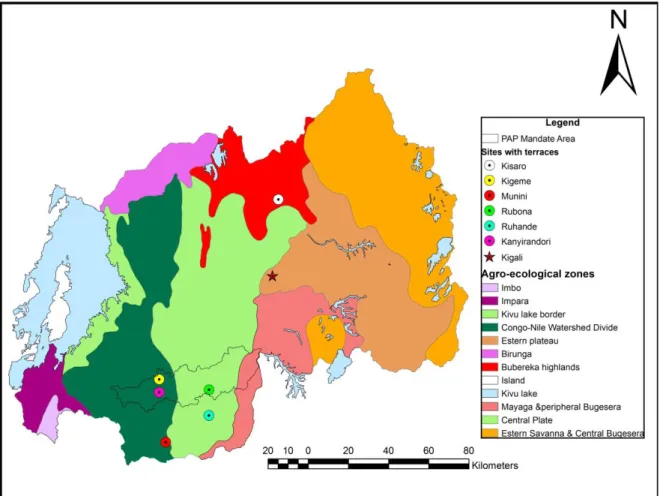
1.6.3 Site selection process
The site selection was inspired from the multi-scale and nested hierarchy land system reasoning (Wielemaker et al., 2001). Therefore, at national level - 1:250,000 – the pedological regions (Prioul and Sirven, 1996) were considered. At this level, while any pedological region could be chosen as an example, the “Ferrasols on hills and Histosols in valleys” sub-pedological region was preferred because of four main reasons: (1) a pedological region with poor soils (Neel, 1972; 1973; 1974. Birasa et al., 1990; Rutunga and Neel, 2006), therefore, more appropriate for demonstration purposes, (2) need of contributing to the alleviation of poverty in Nyaruguru, the poorest District of Rwanda (MINECOFIN, 2013), (3) existence of an ongoing project that could help field visits, (4) existence of historical data (Neel, 1972; 1973; 1974; Rutunga and Neel, 2006). In this sub-pedological region, the Akavuguto watershed was selected. The later was expected to be representative of land units, soil parent materials and soil sequences of a large area in the above sub-pedological region. For more detailed study, the benchmark site was chosen by opening a window/zoom in Akavuguto watershed
(Figure 1.5a & Figure 1.5b). At the site level, and using both technical and FSK, the soil forming factors (Jenny, 1941) and the soil-landscape relationship (Lagacherie et al., 1995;Wielemaker et al., 2001; Park and van de Giesen, 2004) were used to determine auguring points and soil pits. Composite soil samples were taken for each soil and land use type. Pot experimentation was undertaken to test the relevance of FSK as the basis for new technical intervention like efficient fertilizer use.
Figure 1.5a Pedological Regions of Rwanda and the “Ferrasols on hills and Histosols in valleys”
Figure 1.5b Akavuguto watershed and the study area/benchmark.
1.6.4 Study area description
Akavuguto watershed (Figure 1.6) is located in southern Rwanda, Southern province, Nyaruguru District and cut cross 4 administrative Sectors. The climate of this region is described as Cw2-3 (Neel, 1974); which means a temperate climate with 2 to 3 months of dry season, with a mean temperature in the coldest month of less than 18°C. The annual rainfall is above 1500 mm. The area comprises many hills, separated by valleys, with some mountains above 55-80% slope (Figure 1.7). From the hill summits to the valley bottoms, altitude ranges between 1800-1700 m with some mountainous mass at 2,200 m.
Figure 1.6 Akavuguto watershed benchmark in Administrative map of Rwanda (soil legend is explained later).
From a pedological point of view, the watershed belongs to the ‘Pedological Region’ of Entisols on crests, Ferralsols on hills and Histosols in valleys – INEAC8 classification system (Prioul and Sirven, 1981). The parent material is described as Butare Complex – “metaquarzites, mylonites, micaschists, graphitic schists, pegmatites, amphibolites” (Dehandschutter and Buyagu, 1991).
The traditional crops grown in the watershed are sweet potatoes (Ipomea batatas (L.) Lam), peas (Pisum sativum L.), beans (Phaseolus vulgaris L.) and sorghum (Sorghum vulgare Pers.).
8
INEAC. Institut National pour l’Etude Agronomique du Congo belge (a former Belgian classification system for Congo, Rwanda and Urundi).
Figure 1.7 Orthophotos (5 x 5 m) showing major land units of Akavuguto watershed: From left (West) to right (East):
the gradual evolution is from hills and valleys, to mountainous and boxed-valley land units. Source: Swedesurvey (2008)
1.7 Thesis outline
This thesis begins by an abstract, in both English and French. The abstract states, briefly, the problem and presents the main results and practical implications. The thesis per se consists of seven chapters. Chapter 1 starts with the problem statement, followed by justification to the problem, research questions, hypothesis, objectives, overview of the methodology and ends with this outline. Chapter 2 presents and analyses the innovation model (planning environment context) in which the soil map of Rwanda is expected to be used and highlights the key role of the soil resource information in this process. Chapter 3 analyses the contribution of soil science – research and extension - to the Rwandan agriculture development to understand what can be the new perspectives to achieve sustainable development. Chapter 4 demonstrates how the FSK can be formalized and integrated with the scientific soil knowledge and how the integrated scientific and FSK can be used to interpret the rationality of farmers’ practices as a prerequisite for any new intervention at watershed level. Chapter 5 establishes the Soil References System as a mean of understanding the soil spatial distribution law, overtime interpreting and monitoring soil properties and crop yields in relation to different soil types in the watershed. Chapter 6 presents results from a pot experimentation aiming at demonstrating that different soil types occurring in the same AEZ along the catena, may need different types of soil fertility management strategies and that the farmers’ soil nomenclature captures those differences and, therefore, can be used to achieve soil-specific fertility management and replicable technologies in the complex soilscape of Rwanda. Chapter 7 presents the general conclusion and draws some policy and research implications for more effective PIWM. The general framework summarising the philosophy of this thesis is diagramed in Figure 1.8.
Agrosystems, Land Use, Suitable Crops & Soil Fertlity
Management Country Farmer Parent Materials Farmer Soil Types Farmers’ Land Units Participatory Biophysical Analysis Benchmark Watershed Pedological Region Representative composite soil Samples for land evaluation Technical Parent Materials Technical Land Units Technical Soil Series Technical Biophysical Analysis Reference soil profiles description
for soil fertility potential evaluation Experimental trials Site selection process Watershed integrated soil survey process Soil fertility potential evaluation Existing agro-systems analysis Land evaluation (seasonal soil fertility management) Experiment ation Soil fertility management: dynamic phase Soil fertility management: static/stable phase
Figure 1.8 A general framework illustrating the multi-scale and nested hierarchy soil fertility management procedure as used in this thesis. Source: adapted from Rushemuka et al. (2014a).
Chapter II: Agricultural research and extension in Rwanda: evolution of
concepts and the need for capturing the soil factor
Abstract
A retrospective analysis was undertaken to understand how agricultural research and extension reasoning/conceptualization in Rwanda have evolved over the last 80 years, and how they have been fed by the Rwandan biophysical environment understanding. The objective was to appreciate the innovation model in which the soil map of Rwanda is expected to be used. Findings from this study showed that the agricultural research and extension conceptualization has undergone significant progress in relation to the advances in the understanding of the complexity of farmers’ agricultural problems. Among the developed concepts are the Participatory, Integrated Watershed Management and the Mother-Baby trials. However, these models though relevant, have experienced difficulties to be really effective. The fundamental problem appears to be the poor consideration of the soil factor as a natural body and the failure to take into account different soil types when designing experiments, when evaluating data and when extrapolating results. The establishment of communication bridges between scientific and Farmers’ Soil Knowledge (FSK) systems and the catalytic role of the soil scientist at watershed level are likely to alleviate this understanding and minimize the communication problem. In the context of research for development, the watershed should become at the same time, the really world “laboratory” and “experimental site”. The extension should no longer be about a discipline-based or a commodity oriented technology, but a successful integrated watershed model. It was concluded that the soil map of Rwanda, properly complemented with the FSK and circumscribed in the current innovation models, constitute a fundamental contributor to Rwanda’ potential green revolution.
Key words: Research mode, Linear Research & Development model, Participatory Integrated
Watershed Management, Communication language, Rwanda
2.1 Introduction
Green Revolution (GR) as known in Asia was largely made possible by investment in fertilizer, crop responsive varieties and irrigation (Dethier and Effenberger, 2012). With the GR advent (1961-2008), food production increased more rapidly than population growth in all major regions except sub-Saharan Africa (SSA) (Brady and Weil, 2002, World Bank, 2008). In this world region, despite all efforts furnished by different stakeholders (national and international agricultural research, development and research projects and Non Governmental Organizations), the adoption of such inputs and technologies has remained very low and the productivity per land unit has even declined (Keating et al., 2011; Dethier and Effenberger, 2012).
In front of this paradox, common questions in many multi-disciplinary debates and planning meetings are: why should SSA not be like Asia’, why should what went well in other regions fail only in SSA? What have others done?
Because of the differences in the biophysical environment between the Asia regions where green revolution occurred and SSA on the one hand, and taking into account the progress realized in the field of sustainable development on the other hand, the GR in this world region needs a different and updated approach (Herren, 2011; Dethier and Effenberger, 2012). Moreover, the large regional differences within the SSA sub-continent (Vlek, 1995; Kolawole, 2012; Giller et al., 2011) call for several geographically separate GRs (Dethier and Effenberger, 2012). In view to the above considerations, SSA countries, on the basis of the research and development experiences so-far noted, should recalibrate the Asian GR ‘equation’ to adapt it to their own planning environments (biophysical constraints and socio-economic conditions). This will be possible if they understand that they need an education system more appropriate to their biophysical and socio-economic problems (Papadakis, 1975; ISNAR, 1982). From the experience of other continents, the African upcoming GRs must be sustainable in terms of nutrient and water cycles and agro-ecological functions (Keating et al., 2011).
With regard to the above described situation, the mode of research and extension thinking and the institutional arrangements are vital factors to transform existing biophysical and socio-economic information into usable knowledge and technologies (Rhoades, 1999; Raina et al., 2006; Weichselgartener and Karsperson, 2010; Kolawole, 2012).
At national level agricultural research and extension should be based on a clear understanding of the ecological context (climate and soils) in terms of the relatively natural homogenous entities, such as Agro-Ecological Zones (AEZs) and the different soil types within each AEZ. The logic of these two conceptual levels (AEZ and soil types) should be clearly perceived by planners/decision-makers, researchers (crop breeders, agronomists, fertility experts and crop modelers) and extensionists to ensure the required consistency between the soil type where a given technology is developed (e.g. on-station experiment or on-farm experiment) and the analogous soil types where the same technology is transferred (e.g. large up scaling of the best fit technology). We call this soil-specific and transposable intervention. This concept is essential if a GR is to be achieved in the very complex biophysical environment of SSA in general and of Rwanda in particular. To date, the attempt to draw fertilizer recommendations for the entire AEZ has been problematic (Rutunga, 1991; Drechsel et al., 1996, Steiner, 1998; Giller et al., 2011). However, to the author’s knowledge, in Africa, few authors (e.g. Mathieu et al., 1995; Steiner, 1998; Zingore et al., 2007; Sileshi et al., 2010) have clearly noted compelling reasons for systematic consideration of different soil types in the result extrapolation strategy. In Rwanda, after 30 years (1933-1962) of agricultural research during the pre-independence period and 50 years (1962-2012) of the independence period, the questions posed here are: (1) have the agricultural research and extension approaches progressed to cope with the requirement of soil-specific and transposable intervention and, (2) what has been learnt from the past and what can be the place and role