HAL Id: hal-02086972
https://hal.archives-ouvertes.fr/hal-02086972
Submitted on 1 Apr 2019
HAL is a multi-disciplinary open access archive for the deposit and dissemination of sci-entific research documents, whether they are pub-lished or not. The documents may come from teaching and research institutions in France or abroad, or from public or private research centers.
L’archive ouverte pluridisciplinaire HAL, est destinée au dépôt et à la diffusion de documents scientifiques de niveau recherche, publiés ou non, émanant des établissements d’enseignement et de recherche français ou étrangers, des laboratoires publics ou privés.
of real-world wayfinding navigation performance
Antoine Coutrot, Sophie Schmidt, Lena Coutrot, Jessica Pittman, Lynn
Hong, Jan Wiener, Christoph Hölscher, Ruth Dalton, Michael Hornberger,
Hugo Spiers
To cite this version:
Antoine Coutrot, Sophie Schmidt, Lena Coutrot, Jessica Pittman, Lynn Hong, et al.. Virtual naviga-tion tested on a mobile app is predictive of real-world wayfinding naviganaviga-tion performance. PLoS ONE, Public Library of Science, 2019, 14 (3), pp.e0213272. �10.1371/journal.pone.0213272�. �hal-02086972�
Virtual navigation tested on a mobile app is
predictive of real-world wayfinding navigation
performance
Antoine CoutrotID1,2*, Sophie Schmidt1, Lena Coutrot1,3, Jessica Pittman1, Lynn Hong1, Jan M. Wiener4, Christoph Ho¨ lscher5
, Ruth C. Dalton6, Michael Hornberger7*, Hugo J. Spiers1*
1 Institute of Behavioural Neuroscience, Department of Experimental Psychology, Division of Psychology and Language Sciences, University College London, London, United Kingdom, 2 Laboratoire des Sciences du Nume´ rique de Nantes - CNRS - Universite´ de Nantes, Nantes, France, 3 Institut Jean Nicod, ENS, EHESS, CNRS, Paris, France, 4 Department of Psychology, Ageing and Dementia Research Centre, Bournemouth University, Poole, United Kingdom, 5 ETH Zu¨rich, Swiss Federal Institute of Technology, Zu¨rich, Switzerland, 6 Department of Architecture and Built Environment, Northumbria University, Newcastle upon Tyne, United Kingdom, 7 Norwich Medical School, University of East Anglia, Norwich, United Kingdom
*[email protected](AC);[email protected](MH);[email protected](HS)
Abstract
Virtual reality environments presented on tablets and smartphones have potential to aid the early diagnosis of conditions such as Alzheimer’s dementia by quantifying impairments in navigation performance. However, it is unclear whether performance on mobile devices can predict navigation errors in the real world. We compared the performance of 49 partici-pants (25 females, 18-35 years old) at wayfinding and path integration tasks designed in our mobile app ‘Sea Hero Quest’ with their performance at similar tasks in a real-world environ-ment. We first performed this experiment in the streets of London (UK) and replicated it in Paris (France). In both cities, we found a significant correlation between virtual and real-world wayfinding performance and a male advantage in both environments, although smaller in the real world (Cohen’s d in the game = 0.89, in the real world = 0.59). Results in London and Paris were highly similar, and controlling for familiarity with video games did not change the results. The strength of the correlation between real world and virtual environ-ment increased with the difficulty of the virtual wayfinding task, indicating that Sea Hero Quest does not merely capture video gaming skills. The fact that the Sea Hero Quest way-finding task has real-world ecological validity constitutes a step toward controllable, sensi-tive, safe, low-cost, and easy to administer digital cognitive assessment of navigation ability.
Introduction
Virtual reality (VR) provides a powerful means to study and quantify how humans navigate, because the properties of a virtual environment can be completely controlled and repeated across participants. Since the late nineties, it has been a critical tool to understanding how brain regions support navigation and unveiling the structural and functional neural correlates a1111111111 a1111111111 a1111111111 a1111111111 a1111111111 OPEN ACCESS
Citation: Coutrot A, Schmidt S, Coutrot L, Pittman
J, Hong L, Wiener JM, et al. (2019) Virtual navigation tested on a mobile app is predictive of real-world wayfinding navigation performance. PLoS ONE 14(3): e0213272.https://doi.org/ 10.1371/journal.pone.0213272
Editor: Laura Zamarian, Medical University of
Innsbruck, AUSTRIA
Received: August 2, 2018 Accepted: February 19, 2019 Published: March 18, 2019
Copyright:© 2019 Coutrot et al. This is an open access article distributed under the terms of the
Creative Commons Attribution License, which permits unrestricted use, distribution, and reproduction in any medium, provided the original author and source are credited.
Data Availability Statement: We made
available both the processed and raw data used in this manuscript on Open Science Framework:https://osf.io/brjyp/?view_only= 3ff88ad76d1c4babaac541d7ca082f1a.
Funding: Deutsche Telekom supported and funded
this research -https://www.telekom.com/ento HS. Alzheimer’s Research UK funded the analysis
-https://www.alzheimersresearchuk.org/to HS. The funders had no role in study design, data collection
of spatial navigation [1–4]. VR tests of spatial cognition have proved more sensitive in identify-ing spatial navigation deficits in patient populations compared to more classic visuospatial ‘pencil-and-paper’ tests like the Mental Rotation Test [5]. VR has the added advantage to be a less costly and safer alternative to real-world navigation tests, which are time and space con-suming, as well as difficult to administer to a population sometimes less able to walk [6]. Until recently, most VR used in research was presented on a desktop display and movement con-trolled via a joystick or keyboard. Such an interface presents difficulties for older people, less exposed to technology than younger participants [7]. However, with the advent of tablet and smart-phone touch screen mobile devices, older participants have found engaging in VR tasks much easier and intuitive than with desktop computers [8,9]. As a consequence, mobile devices have recently been used in several fields such as neuropsychological assessment [10], stroke rehabilitation [11] and mental health [12]. We recently developed a VR navigation task for mobile and tablet devices—Sea Hero Quest—with the aim that this may provide an early diagnostic tool for Alzheimer’s Disease (AD) [13]. For this test to be useful it is important that it has real-world validity, with errors on the VR task predicting errors in real-world navigation experience.
Past research comparing navigation in real and VR environments has generally found a good concordance in performance across both environments in the normal population [14–
19], in younger and older age groups [20], in individuals with brain injury [21,22], in chronic stroke patients [23], and in patients with Mild Cognitive Impairment (MCI) or early AD [20,
24], for reviews see [25,26]. However, this consistency seems to be modulated by the type of spatial navigation task, as a previous study showed that performance in real life and virtual environments were similar for tasks such as landmark recognition or route distance estimate, but different for pointing to the beginning and endpoint of the route, or drawing a map of the route [27].
Most prior studies comparing VR and real-world navigation performance have used desk-top VR or immersive VR to simulate environments, and paper and pencil tests such as line ori-entation, road map, or delayed recall when assessing ‘real-world navigation behavior’. A few studies made use of actual navigation tasks but often in a limited spatial range, like the lobby of a hospital [20]. A notable exception is [28], where the authors tested 978 military college stu-dents on a 6 km orienteering task and replicated many laboratory-based findings, including gender differences. However, the authors did not test their participants in a VR task and were thus unable directly compare the two environments.
Numerous studies found a male advantage for navigation in VR tasks [13,29–32], but only a few looked for gender differences in real-world navigational tasks [28,33]. This led some authors to suggest that previously reported gender differences in spatial ability may be driven by familiarity with technology, men being more comfortable with virtual tasks than women who are sometimes less exposed video games [34].
Here, for the first time we directly compared in a within-subject design the spatial navi-gation performance measured on a mobile device with our Sea Hero Quest virtual tasks, and in a large-scale real-world environment covering a whole neighborhood of London (Covent Garden, South of the British Museum) and of Paris (South of the Montparnasse cemetery). We designed the real-world counterparts of the Sea Hero Quest wayfinding and path inte-gration tasks, which are known to tap into different cognitive processes [13]. The wayfind-ing task relies on various skills, includwayfind-ing interpretation of a map, plannwayfind-ing a multi-stop route, memory of the route, monitoring progress along the route and updating of route plan, and transformation of birds-eye perspective to an egocentric perspective needed for navigation [35], while the path integration task typically only requires working memory processes [36].
and analysis, decision to publish, or preparation of the manuscript.
Competing interests: We received funding from
the German company Deutsche Telekom. This does not alter our adherence to PLOS ONE policies on sharing data and materials.
We hypothesized that performance in the real world in both cities will significantly corre-late with performance in the virtual environment. Based on our original mobile-based results [13] and on previous gender differences found in navigational studies in the real world [28], we hypothesized that males will perform better than females in both environments. Finally, we predicted that familiarity with video games will not influence performance in either environ-ment, in line with a previous study showing no effect of computer experience on spatial mem-ory errors [7]. In particular, the correlation between the real-world wayfinding performance and the performance at the first training Sea Hero Quest level—where no spatial ability is required—should be null. Comparing this study to the original large dataset would enable test-ing whether our results hold true not simply in small cohorts but on a population level.
Methods
This study has been approved by UCL Ethics Research Committee. The ethics project ID num-ber is CPB/2013/015. Written consent was obtained from each participant and the data were analyzed anonymously. Participants were tested on specific levels from Sea Hero Quest [13] on a tablet, and then on equivalent tasks in the real world, seeFig 1. Participants were also asked to answer a few demographic questions. We first ran this experiment in London in sum-mer/fall 2017. We then replicated it with a different team in Paris in spring 2018. The whole experiment lasted around three hours.
Participants
In London—We tested a total of 30 participants (15 males) but data from 1 participant was
missing due to a technical problem and real-world wayfinding data from 6 participants (3 males and 3 females) were discarded due to GPS recording issues. Subsequent analyses hence include 23 participants (11 males), aged 18-30 y.o. (M = 21.52, s.d. = 1.81). Participants had normal or corrected to normal vision and gave their written consent to participate. Path inte-gration data was not collected for the first 11 participants as this task was not yet implemented. Participants received 3 class credits or £20 for their participation.
In Paris—We tested a total of 30 participants (15 males), but real-world wayfinding data
from four participants (1 male and 3 females) were discarded due to GPS recording issues. Subsequent analyses hence include 26 participants (14 males), aged 18-30 y.o. (M = 23.15, s.d. = 2.52). Participants had normal or corrected to normal vision and gave their written con-sent to participate. Participants received 30 euros for their participation.
Virtual tasks
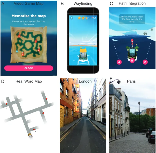
We devised a mobile video game designed to measure human spatial navigation ability through gameplay—Sea Hero Quest (SHQ,www.seaheroquest.com). This video game involves navigating a boat in a virtual environment (lake or river networks) and has been extensively described in [13]. It features two main tasks, which have been designed to tackle different aspects of spatial navigation.
1- Wayfinding. Participants were required to view a map displaying current position and
goal locations to find (Fig 1A and 1B). Participants could study the map without time restric-tions and had to navigate to the goal locarestric-tions in the order indicated, e.g. goal 1 must be found first, then goal 2, etc. Goals were buoys with flags marking the goal number. The task is com-plete when all goals have been located. If the participant takes more than a set time, an arrow indicates the direction along the Euclidean line to the goal to aid navigation. On basis of the data from the mobile video game, we selected a subset of 5 of the total 75 levels in the game that varied in difficulty. In order to compare the data recorded in this study to the
population-level dataset, we chose three population-levels of increasing but moderate difficulty appearing quite early in the game (levels 6, 11 and 16). Indeed, the sample size of the mobile video game logically dropped rapidly across levels (see [13]). We also included a training level (level 1) and a level of great difficulty (level43), seeS1 Fig. The helping arrow appeared after 80 s in level 1, 70 s in level 6, 80 s in level 11, 80 s in level 16 and 200 s in level 43.
Performance was quantified with the Euclidean distance travelled in each level (in pixels). The coordinates of participants’ trajectories were sampled at Fs = 2 Hz. We summed the dis-tance travelled over levels 6 to 43. We did not include level 1 because it did not require any spatial ability (the goal was visible from the starting point) and was only designed to assess
Fig 1. Task in real world (bottom row) vs virtual environment (top row). (A-B) Wayfinding task in the video game: participants had to
memorize a map and navigate as fast as possible toward an ordered set of goals. Participants played Sea Hero Quest on a tablet. (C) Path Integration task in the video game: participants had to navigate in a maze until they find a flare and shoot it back toward their starting position. (D) Wayfinding task in the real world. Identical as the virtual task, but takes place in the streets of (E) London and (F) Paris. All other maps are displayed in supportingS1–S4Figs.
participants’ ability to learn to control the boat. We only considered level 1 data inFig 2Cto compare participants’ performance in real life with the distance they travelled in each level.
2- Path Integration. During path integration, participants integrate perceived ego motion
while they move to update their position and orientation. It is a more basic navigation mecha-nism than wayfinding, which typically only requires working memory processes [36]. A well-established tool in the study of path integration is the triangle completion task, where partici-pants move along the first two sides of a triangular pathway, and then are asked to return to their starting position, thus completing the triangle [37,38]. The task we designed here is a direct implementation of this paradigm. Participants were required to navigate along a river
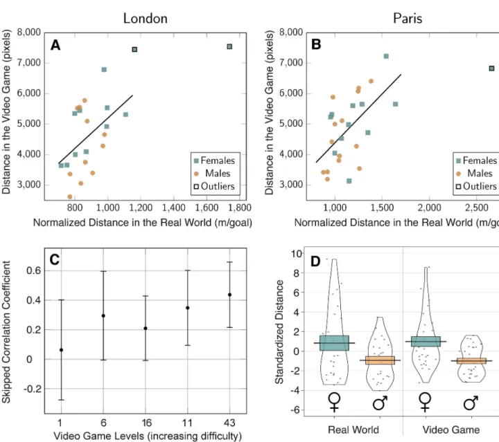
Fig 2. Spatial ability at a wayfinding task in real world vs virtual environment. (A) Correlation between the distance navigated in the video game and the
normalized distance navigated in the real-world wayfinding task in London (skipped Pearson’sr = 0.46, p = 0.01) and (B) in Paris (skipped Pearson’s r = 0.57, p = 0.001). Real-world normalized distance is the distance travelled by participants divided by the number of goals they reached. Outliers have been determined with skipped-correlation. (C) Skipped correlation coefficients between the distance navigated in each video game level and the total normalized distance navigated in the real world. Video game levels are sorted by increasing difficulty according toTable 1. (D) Gender differences at the wayfinding task in the video game (right) and in the real world (left). Distances have been standardized (zscore) to allow a direct comparison between environments. Black dots represent individual data points. Error bars represent standard errors.
with bends until they find a flare and shoot it back toward their starting position. Participants could choose among three directions, as shown inFig 1C. We selected a subset of 5 levels that varied in difficulty: level 14 had one bend, level 34 three, level 44 two, level 54 four and level 74 five, seeS4A Fig.
Performance was measured with the number of stars obtained by the player. Stars were awarded based on participant’s choice between 3 proposed directions: 3 stars for the correct answer (their starting point), 2 stars for the second closest direction, and 1 star for the third closest direction.
Real-world task
1- Wayfinding. The real-world wayfinding task consisted of 6 wayfinding trials which varied
in difficulty in terms of the number of streets to be navigated, the number of goals and the rela-tive location of the goals to each other. Each trial consisted of a different starting point and required exploration through different street networks South of the British Museum in Lon-don (Covent Garden area) and South of the Montparnasse cemetery in Paris. We chose less busy streets to avoid traffic and made sure the participants were not familiar with them. Before each trial, participants were shown a map that only indicated the facing direction, the network of the local streets and the location and the order of the goals (in London seeS2 Fig, in Paris seeS3 Fig). Maps were displayed on a tablet (IPad MP24B/A, 9.7 inches). The goals were doors and gates with distinct features (e.g. specific colour, size, or material). Participants had up to 1 min to memorize the map. Once the minute was up, the map was removed and they were asked to go locate the goals. During navigation they were provided with colour photographs of the goal. To calibrate the time limit of each route, we pilot tested 3 participants in London and 2 participants in Paris, not included in the analyses. We chose these time limits to allow for a few mistakes at a reasonable walking pace. Pilot testing indicated that if participants required any longer than that these time restraints they were likely guessing and had failed to remember the goal locations or street layout. To take into account the fact that some participant did not finish some routes, we divided this distance by the number of goals reached by the participant plus 1. We added 1 to cope with cases where the participant didn’t reach any goal (this only happened once). We refer to this as the metric normalized distance, and summed it over routes 1 to 6. If participants reached the limits of the defined region shown in the map they had stud-ied then they were told by the experimenter that they had reached the edge of the search area and should turn back. In London, route one: 6 minutes, route two: 6 minutes, route three: 6:30 minutes, route four: 6:30 minutes, route five: 12 minutes, route six: 14 minutes. In Paris, route one: 5 minutes, route two: 8 minutes, route three: 8 minutes, route four: 9 minutes, route five: 16 minutes, route six: 20 minutes.
The coordinates of participants’ trajectories were sampled at Fs = 1 Hz with the experiment-er’s smartphone GPS via the Beeline app. We visually inspected all recorded GPS trajectories to deal with potential losses of signal. For losses of signal where the participant did not make any turn, we linearly interpolated between the first and the last missing points. When we couldn’t reconstruct the trajectory because the participant changed direction during the loss of signal, we discarded the data (5 trials out of 180 in Paris, 6 out of 180 in London). Performance was quantified with the Euclidean distance travelled in each route (in meters).
2- Path Integration. The real-world path integration task consisted of 4 path integration
trials which varied in difficulty in terms of the number of turns they featured (1, 2, 3 and 4 turns, seeS4B Fig). To avoid familiarity effect, path integration routes were chosen not to intersect with any wayfinding route. Participants were informed when they were at a starting point then they were asked to follow the experimenter to an endpoint where they were
instructed to point back toward the starting point. We used a numeric compass to precisely record the direction. Performance was defined as the inverse of the angle between the direction pointed toward by the participant and the ground-truth, in degrees. We then summed the absolute values of the path integration error angles.
Results
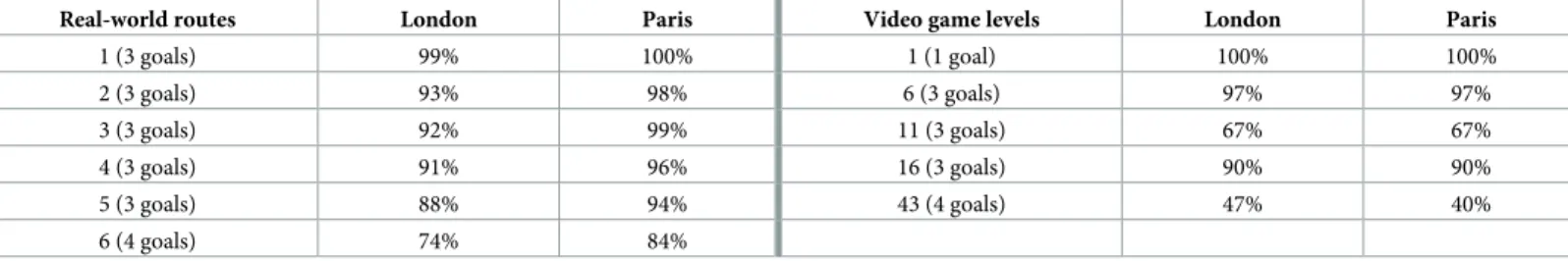
Table 1reports the difficulty of each wayfinding route in the real-world task as the percentage of goals reached by the participants before the time limit. This goes from 99% in London (100% in Paris) for route 1 down to 74% in London (84% in Paris) for route 6.Table 1also reports the difficulty of each wayfinding level in the video game task as the percentage of par-ticipants that managed to complete the level before the helping arrow appeared. 100% partici-pants successfully completed the first training level while only 47% participartici-pants in London (40% in Paris) completed level 43. Interestingly, level 11 seemed harder than level 16, which might be due to level 11 requiring participants to turn back to meet the goals in order, which was not the case in level 16 (seeS1 Fig).
Table 2reports the difficulty of each path integration route in the real-world task in Paris and London as the mean absolute error angle, and the difficulty of each path integration level in the video game task in Paris as the percentage of correct answers (i.e. the percentage of par-ticipants that received three stars). London data is fragmentary (based on 19 parpar-ticipants, no real-world route with 4 turns) since the path integration task was not fully implemented yet. Further analyses are only based on path integration data recorded in Paris.
Correlation between performance in real world and virtual environments
To visualize participants’ raw data in real world and virtual environments we created a video showing on the left side the trajectories of participants in London’s route 6 and on the right side the trajectories of the same participants in the 43rd level of Sea Hero Quest (S1 Video).
Table 1. Difficulty of the virtual and real-world wayfinding task. Left: Real-world wayfinding task. For each route, percentage of the goals reached by the participants in
London (23 participants) and in Paris (26 participants) within the time limit. Right: Video game wayfinding task. For each level, percentage of participants who completed the level before the helping arrow appeared.
Real-world routes London Paris Video game levels London Paris
1 (3 goals) 99% 100% 1 (1 goal) 100% 100% 2 (3 goals) 93% 98% 6 (3 goals) 97% 97% 3 (3 goals) 92% 99% 11 (3 goals) 67% 67% 4 (3 goals) 91% 96% 16 (3 goals) 90% 90% 5 (3 goals) 88% 94% 43 (4 goals) 47% 40% 6 (4 goals) 74% 84% https://doi.org/10.1371/journal.pone.0213272.t001
Table 2. Difficulty of the virtual and real-world path integration task in Paris (30 participants) and in London (19 participants). Left: Real-world path integration
task. For each route, average of the absolute value of the error angle (M ± SE, in degree). Right: Video game path integration task. For each level, we show the percentage of correct answers (3 stars).
Real-world routes London Paris Video game levels London Paris
1 (1 turn) 16.5˚± 4.3 19.8˚± 4.5 14 (1 turn) 79% 87% 2 (2 turns) 19.3˚± 4.3 21.7˚± 2.8 34 (2 turns) 53% 43% 3 (3 turns) 23.1˚± 4.1 19.5˚± 2.4 54 (3 turns) 68% 70% 4 (4 turns) 25.6˚± 4.4 44 (4 turns) 63% 73% 74 (5 turns) 16% 20% https://doi.org/10.1371/journal.pone.0213272.t002
The relationship between the wayfinding performance in the real world and in the video game is shownFig 2A(in London) andFig 2B(in Paris). One can notice a few outliers in the upper right corner of the scatter plots. Traditional Pearson’s correlation measure is known to be highly sensitive to outliers, which can severely bias the estimation of the strength of the associ-ation among the bulk of the points [39]. To deal with this, we used skipped-correlation, which protects against outliers by taking into account the overall structure of the data [40]. Outliers are detected using a projection method, removed, and Pearson’s correlation is computed using the remaining data. Hence, Pearson’s skipped correlation is a direct reflection of Pearson’s r. We used an implementation of this algorithm available in a free toolbox [41]. The detected outliers are tagged inFig 2A and 2Bwith black edges, and discarded from further analysis. 95% Confidence Intervals (CI) were computed via bootstrap: pairs of observations were resam-pled with replacement and their correlation values obtained and sorted. Values between the 2.5 and 97.5 percentiles yielded the 95% CI. Skipped correlation were significant both in Lon-don (r = 0.46, 95% CI = [0.14, 0.68], p = 0.01) and in Paris (r = 0.57, 95% CI = [0.37, 0.76], p = 0.001).
To confirm that our virtual task captured participants’ wayfinding ability, we checked whether the strength of the correlation between performance in real world and in the video game was modulated by the difficulty of the virtual task. Under this hypothesis, the correlation should be null between real world and level 1 performance, since level 1 is a training level where no spatial ability is required: the end goal is visible from the starting point. The correla-tion should then increase with the difficulty of the level. We broke down the global correlacorrela-tion score for each Sea Hero Quest level, comparing participants’ performance in real life with the distance they travelled in each level. To increase the sample size, we combined the data recorded in both London and Paris. In order to take into account the difference in route length between cities (the task in Paris being slightly longer than the one in London), we calculated zscores of the performance for each level before combining the data of the two cities. In the following we work with this cross-city normalized metric, called Standardized Distance. The skipped correlation coefficient between the Standardized Distance in the real world and in level 1 is close to 0 (r = 0.06), confirming that this instruction level does not measure spatial ability. We sorted the game levels by increasing difficulty based on the results ofTable 1: level 1, 6, 16, 11 and 43. As shown inFig 2C, the skipped correlation coefficient increases with level difficulty, from r = 0.06 in level 1 to r = 0.44 in level 43.
The skipped correlation between real world and video game path integration score in Paris was not significant, r = -0.23, 95% CI = [-0.51, 0.08], p = 0.11. However, the sign of the correla-tion is logical since higher scores mean better performance in the game (number of stars) but not in the real-world task (error angle). In London, the first 11 participants were not tested on path integration as this task was not yet designed. The skipped correlation based on the other 19 participants is consistent with Paris data: r = -0.40, 95% CI = [-0.73, 0.07], p = 0.05. How-ever, correlational analyses with small sample size can lead to strongly biased correlation esti-mates and this result should be considered with caution.
Gender differences
For the wayfinding task, we found that in both environments male participants had an advan-tage, although smaller in the real world (Fig 2D). In the real world, Cohen’sd = 0.59, 95% CI =
[0.02 1.15], t(47) = -2.08, p = 0.04; in the video game, Cohen’sd = 0.89, 95% CI = [0.35 1.42],
t(56) = -3.43, p = 0.001.
For the path integration task in Paris, we did not find a significant gender difference. How-ever, the tendency was similar to the wayfinding results, with male having a small advantage in
both environments, smaller in the real world, seeS5 Fig. In the real world, Cohen’sd = -0.21,
95% CI = [-0.91 0.49], negative values correspond to a male advantage; in the video game, Cohen’sd = 0.29, 95% CI = [-0.40 0.99], positive values correspond to a male advantage. The
gender effect size is much smaller for path integration than for wayfinding and is not significa-tive, as shown by the wide 95% CIs.
Influence of familiarity with video games
We showed that the correlation between performance in real world and in the training level of the virtual environment was weak, indicating that gaming ability does not predict navigation ability in the real world (Fig 2C). To further test this claim, we asked participants the average duration they play video games per week and used this variable along with gender to predict performance in the real-world and in the virtual environment. On average, females played video games 2.99± 8.38 hours per week and males played 2.95 ± 4.21 hours per week. To con-trol for the influence of familiarity with video games on real-world and virtual spatial abilities, we computed a multiple linear regression to predict performance based on gender and on the time participants spent playing video game (VGT), in hours per week.
With standardized distances recorded in the real-world wayfinding task, gender was a sig-nificant predictor (t(47) = −2.22, p = 0.03), but not VGT (t(47) = 0.31, p = 0.76). Similarly,
with standardized distances recorded in the virtual wayfinding task, gender was a significant predictor (t(55) = −3.44, p = 0.001), but not VGT (t(55) = −0.99, p = 0.32).
With error angles recorded in the real-world path integration task, gender was not a signifi-cant predictor (t(55) = −0.65, p = 0.52), nor was VGT (t(55) = 1.09, p = 0.28). Similarly, with
standardized flare accuracy recorded in the virtual path integration task, gender was not a sig-nificant predictor (t(55) = −0.17, p = 0.87), nor was VGT (t(55) = 0.09, p = 0.92).
Correlation between wayfinding and path integration
The skipped correlation between path integration and wayfinding scores is not significant in the real world (Paris data): r = -0.06, 95% CI = [-0.34 0.44], nor in the virtual environment: r = -0.18, 95% CI = [-0.49 0.15]. Higher scores mean better performance in the path integration task in the game (number of stars) lower score mean better performance in the path integra-tion task in the real-world task (error angle), and in the wayfinding tasks in both environments (distance).
Comparison to the population-level original dataset
To check whether the 60 participants we recruited for this experiment were representative of the much larger dataset recorded with the mobile version of Sea Hero Quest [13], we plotted inFig 3the performance of the participants at this study (vertical red dotted lines) against the corresponding distribution of the performance of the French and British Sea Hero Quest play-ers from the original dataset. Since the number of playplay-ers per level drops rapidly, we focused on level 11 to maximise the difficulty / number of players ratio (N = 78,724, see [13] for full data).Fig 3clearly shows that the performance of the participants recruited for this study closely follows the performance distribution of the original dataset. Gender differences fol-lowed the same direction in this study (Cohen’sd = 0.81, 95% CI = [0.28 1.33]) as in the
subsample of the original dataset (Cohen’sd = 0.40, 95% CI = [0.39 0.42], positive values
Discussion
We report evidence that wayfinding navigation performance on a mobile app-based VR navi-gation task (Sea Hero Quest) is significantly correlated with performance in a real-world city street wayfinding task. We directly compared participants performance at a subset of Sea Hero Quest wayfinding levels with their performance at an equivalent task in the Covent Garden area, London. We found a strong correlation between the distance participants travelled in the video game (in pixels) and in the real-world street network (in meters, measured by a GPS device). We replicated this result with another set of participants in the Montparnasse area, Paris. The high similarity of the results in the two cities is a strong indicator of the robustness of the results presented above. Our findings are consistent with a number of studies that showed that spatial navigation assessment in a desktop VR [15,16,18,20,22,23,27] and immersive VR [17,42] environments transferred well to the real world, and extend them to tablet device presentation and real-world spatial task spanning complex street networks. How-ever skill assessment don’t always generalize from VR to the real world. For instance reading
Fig 3. Comparison with the large scale video game dataset. Distance in the Video Game (level 11) of the French and British participants
tested in the original Sea Hero Quest database (N = 78,724, blue histogram), see [13] for full data. The red dotted vertical lines represent the performance of the participants recorded in the current study.
skills assessed in a digital device can be partially predicted by participant’s ability to perform basic computer tasks [43]. The similarity both in term of performance and of gender difference of this study with the original large scale Sea Hero Quest study [13] suggests that our findings hold true not simply in small cohorts but on a population level.
We found a significant male advantage in the wayfinding task in both real world and virtual environments, although weaker in the real world. This difference in effect size between the two environments couldn’t be explained by males being more familiar with video games, as sug-gested in a previous study [34] for three reasons. First, our male and female participants reported playing video games the same average duration per week (2.95 vs 2.99 hours per week). Second, when using gender and time playing video games (VGT) as covariates in a lin-ear model to predict wayfinding performance in the real world (resp. in the virtual environ-ment), gender came out as a significant predictor, but not VGT. Third, we found a very weak correlation coefficient (skipped Pearson’s r = 0.06) between the performance at the real-world wayfinding task and at the first training Sea Hero Quest level, which did not require any spatial ability (the endpoint being visible from the start). The strength of the correlation increased with the difficulty of the video game level (up to r = 0.44 in level 43), indicating that Sea Hero Quest does not merely capture video gaming skills. The discrepancy with [34] might stem from the difference between tasks, Richardson et al.’s task being closer to the path integration task than to the wayfinding task discussed in this paragraph. The underlying causes of gender differences in spatial ability are still debated in the literature and include sex hormones varia-tion, evoluvaria-tion, differences in self-confidence and anxiety [18]. In a previous paper based on the global video game dataset, we showed that gender differences in spatial ability measured in the game correlate with gender differences in the society measured with the Gender Gap Index (World Economic Forum) [13].
We did not find a significant correlation between the performance at the real world and the Sea Hero Quest path integration task. At least three reasons could account for this null result. First, as mentioned in the introduction, the consistency between spatial navigation ability in the real world and in a virtual environment task depends on the type of navigational task [27]. In particular, the aforementioned study reported a poor concordance for a task involving pointing to the beginning and endpoint of the route, which is quite close to our path integra-tion task. This hypothesis is consistent with the weak correlaintegra-tions we found between wayfind-ing and path integration performances, both in the real world and in the virtual environment: the two tasks involve different cognitive processes, which don’t generalize similarly from one environment to the other. The wayfinding task requires quite elaborate processing, while the path integration only requires working memory processes (seeIntroduction). Second, this null result could be caused by the low sensitivity of our virtual path integration task. Indeed, while in the real-world performance was a continuous variable defined as the inverse of the error angle, in Sea Hero Quest it could only take three values: one, two, or three stars. This ternary metric might not be sensitive enough to capture subtle differences in the moderate sample size used in this study (60 participants), unlike the original Sea Hero Quest study on mobile and tablet (2.5m participants) [13]. Third, one could argue that path integration in a city is differ-ent from path integration in a controlled virtual environmdiffer-ent, as there are environmdiffer-ental structures (e.g. street grid) and landmarks (e.g. buildings), which may help to judge distances and directions. This would explain the small difference in mean error angle captured by the real-world path integration routes between supposedly easy (one turn) and difficult (four turns) routes, seeTable 2.
Altogether, these results constitute a step toward the ability to remotely test people. This is particularly valuable when certain categories of the population have difficulties in mobility, like older people. Currently our results focused on young university students, and it will be
useful to extend to a broader population including elderly participants. Spatial ability assess-ment provides the potential to act as an early stage diagnostic tool for Alzheimer’s deassess-mentia (AD), because spatial disorientation is one of the earliest symptoms [24,44–48]. Currently there is no standardized test for navigation deficits with AD patients, as diagnostics measures are still focused on episodic memory deficits, despite their low sensitivity and specificity for identifying at-risk individuals [26]. Sea Hero Quest wayfinding task having real-world ecologi-cal validity holds future promise for controllable, sensitive, safe, low-cost, and easy to adminis-ter digital cognitive assessment.
Supporting information
S1 Fig. Wayfinding virtual task. Maps of wayfinding Sea Hero Quest levels 1, 6, 11, 16 and
43. Starting position and facing direction are indicated by a pale blue arrow, ordered goals by red flags. Participants must memorize the map, and then navigate towards the goals in the right order as quick as possible.
(PDF)
S2 Fig. Wayfinding real-world task in London (UK). Maps of real-world wayfinding routes
(top). Starting position and facing direction are indicated by a yellow arrow, ordered goals by red dots. Participants must memorize the map, and then walk towards the goals in the right order as quick as possible. Goals are materialized by remarkable doors (bottom).
(PDF)
S3 Fig. Wayfinding real-world task in Paris (France). Maps of real-world wayfinding routes
(top). Starting position and facing direction are indicated by a green arrow, ordered goals by yellow dots. Participants must memorize the map, and then walk towards the goals in the right order as quick as possible. Goals are materialized by remarkable facade (bottom).
(PDF)
S4 Fig. Path integration task in the virtual and real-world environments. A—Maps of Sea
Hero Quest path integration levels 14, 34, 44, 54 and 74. B—Itineraries of the path integration task in Paris (France). Each color corresponds to a different itinerary.
(PDF)
S5 Fig. Path integration gender effect. Gender differences for the path integration task in the
video game (right) and in the real world (left) in Paris. In the real world, path integration per-formance is the opposite of the average error angle. In the video game, path integration perfor-mance is the average number of stars. Both measures have been standardized for comparison. Black dots represent individual data points. Error bars represent standard errors.
(PDF)
S1 Video. Visualization of the wayfinding task in London and in the video game. Credits to
OpenStreetMap contributors. (MP4)
Acknowledgments
We thank Emmanuelle Bourigault and Mariam Yusuf for help in collecting pilot data in London.
Author Contributions
Data curation: Antoine Coutrot, Sophie Schmidt, Jessica Pittman, Lynn Hong. Formal analysis: Antoine Coutrot, Jan M. Wiener.
Funding acquisition: Michael Hornberger, Hugo J. Spiers.
Investigation: Antoine Coutrot, Sophie Schmidt, Lena Coutrot, Jessica Pittman, Lynn Hong. Methodology: Antoine Coutrot, Sophie Schmidt, Lena Coutrot, Hugo J. Spiers.
Project administration: Antoine Coutrot, Hugo J. Spiers. Supervision: Antoine Coutrot, Hugo J. Spiers.
Validation: Antoine Coutrot. Visualization: Antoine Coutrot.
Writing – original draft: Antoine Coutrot, Hugo J. Spiers.
Writing – review & editing: Antoine Coutrot, Jan M. Wiener, Christoph Ho¨lscher, Ruth C.
Dalton, Michael Hornberger, Hugo J. Spiers.
References
1. Maguire EA, Burgess N, Donnett JG, Frackowiak RS, Frith CD, O’keefe J. Knowing where and getting there: a human navigation network. Science. 1998; 280(5365):921–924.https://doi.org/10.1126/ science.280.5365.921PMID:9572740
2. Pine DS, Grun J, Maguire EA, Burgess N, Zarahn E, Koda V, et al. Neurodevelopmental aspects of spa-tial navigation: a virtual reality fMRI study. Neuroimage. 2002; 15(2):396–406.https://doi.org/10.1006/ nimg.2001.0988PMID:11798274
3. Epstein RA, Patai EZ, Julian JB, Spiers HJ. The cognitive map in humans: spatial navigation and beyond. Nature neuroscience. 2017; 20(11):1504–1513.https://doi.org/10.1038/nn.4656PMID:
29073650
4. Ekstrom AD, Spiers HJ, Bohbot VD, Rosenbaum RS. Human Spatial Navigation. Princeton University Press; 2018.
5. Mitolo M, Gardini S, Caffarra P, Ronconi L, Venneri A, Pazzaglia F. Relationship between spatial ability, visuospatial working memory and self-assessed spatial orientation ability: a study in older adults. Cogni-tive Processing. 2015; 16(2):165–176.https://doi.org/10.1007/s10339-015-0647-3PMID:25739724 6. Lokka IE, C¸ o¨ltekin A, Wiener J, Fabrikant SI, Ro¨cke C. Virtual environments as memory training devices
in navigational tasks for older adults. Scientific Reports. 2018; 8(10809):1–15.
7. Moffat SD, Zonderman AB, Resnick SM. Age differences in spatial memory in a virtual environment navigation task. Neurobiology of Aging. 2001; 22:787–796.https://doi.org/10.1016/S0197-4580(01) 00251-2PMID:11705638
8. Tu S, Wong S, Hodges JR, Irish M, Piguet O, Hornberger M. Lost in spatial translation–A novel tool to objectively assess spatial disorientation in Alzheimer’s disease and frontotemporal dementia. Cortex. 2015; 67:83–94.https://doi.org/10.1016/j.cortex.2015.03.016PMID:25913063
9. Tsai HyS, Shillair R, Cotten SR, Winstead V, Yost E. Getting grandma online: are tablets the answer for increasing digital inclusion for older adults in the US? Educational Gerontology. 2015; 41(10):695–709.
https://doi.org/10.1080/03601277.2015.1048165PMID:26877583
10. Ruggeri K, Maguire A´ , Andrews JL, Martin E, Menon S. Are we there yet? Exploring the impact of trans-lating cognitive tests for dementia using mobile technology in an aging population. Frontiers in aging neuroscience. 2016; 8:21.https://doi.org/10.3389/fnagi.2016.00021PMID:27014053
11. Mallet KH, Shamloul RM, Corbett D, Finestone HM, Hatcher S, Lumsden J, et al. Recovernow: Feasibil-ity of a mobile tablet-based rehabilitation intervention to treat post-stroke communication deficits in the acute care setting. PloS one. 2016; 11(12):e0167950.https://doi.org/10.1371/journal.pone.0167950
PMID:28002479
12. Area´n PA, Ly KH, Andersson G. Mobile technology for mental health assessment. Dialogues in clinical neuroscience. 2016; 18(2):163. PMID:27489456
13. Coutrot A, Silva R, Manley E, de Cothi W, Sami S, Bohbot V, et al. Global determinants of navigation ability. Current Biology. 2018; 28:1–6.https://doi.org/10.1016/j.cub.2018.06.009
14. Witmer BG, Bailey JH, Knerr BW, Parsons KC. Virtual spaces and real world places: transfer of route knowledge. International Journal of Human-Computer Studies. 1996; 45(4):413–428.https://doi.org/10. 1006/ijhc.1996.0060
15. Ruddle RA, Payne SJ, Jones DM. Navigating buildings in “desk-top” virtual environments: Experimental investigations using extended navigational experience. Journal of Experimental Psychology: Applied. 1997; 3(2):143–159.
16. Richardson AE, Montello DR, Hegarty M. Spatial knowledge acquisition from maps and from navigation in real and virtual environments. Memory & cognition. 1999; 27(4):741–750.https://doi.org/10.3758/ BF03211566
17. Conroy RA. Spatial navigation in immersive virtual environments. University College London; 2001. 18. Wolbers T, Hegarty M. What determines our navigational abilities? Trends in Cognitive Sciences. 2010;
14(3):138–146.https://doi.org/10.1016/j.tics.2010.01.001PMID:20138795
19. Ventura M, Shute V, Wright TJ, Zhao W. An investigation of the validity of the virtual spatial navigation assessment. Frontiers in psychology. 2013; 4(852):1–7.
20. Cushman LA, Stein K, Duffy CJ. Detecting navigational deficits in cognitive aging and Alzheimer dis-ease using virtual reality. Neurology. 2008; 71(12):888–895.https://doi.org/10.1212/01.wnl. 0000326262.67613.fePMID:18794491
21. Livingstone SA, Skelton RW. Virtual environment navigation tasks and the assessment of cognitive def-icits in individuals with brain injury. Behavioural Brain Research. 2007; 185(1):21–31.https://doi.org/10. 1016/j.bbr.2007.07.015PMID:17727970
22. Sorita E, N’Kaoua B, Larrue F, Criquillon J, Simion A, Sauze´on H, et al. Do patients with traumatic brain injury learn a route in the same way in real and virtual environments? Disability and Rehabilitation. 2013; 35(16):1371–1379.https://doi.org/10.3109/09638288.2012.738761PMID:23244232 23. Claessen MH, Visser-Meily JM, de Rooij NK, Postma A, van der Ham IJ. A direct comparison of
real-world and virtual navigation performance in chronic stroke patients. Journal of the International Neuro-psychological Society. 2016; 22(4):467–477.https://doi.org/10.1017/S1355617715001228PMID:
26689246
24. Coughlan G, Coutrot A, Khondoker M, Minihane AM, Spiers H, Hornberger M. Impact of Sex and APOE Status on Spatial Navigation in Pre-symptomatic Alzheimer’s disease. bioRxiv. 2018;287722.
25. Cogne´ M, Taillade M, N’Kaoua B, Tarruella A, Klinger E, Larrue F, et al. The contribution of virtual reality to the diagnosis of spatial navigation disorders and to the study of the role of navigational aids: A sys-tematic literature review. Annals of Physical and Rehabilitation Medicine. 2017; 60(3):164–176.https:// doi.org/10.1016/j.rehab.2015.12.004PMID:27017533
26. Coughlan G, Laczo´ J, Hort J, Minihane AM, Hornberger M. Spatial navigation deficits—overlooked cog-nitive marker for preclinical Alzheimer disease? Nature Reviews Neurology. 2018.https://doi.org/10. 1038/s41582-018-0031-xPMID:29980763
27. van der Ham IJ, Faber AM, Venselaar M, van Kreveld MJ, Lo¨ffler M. Ecological validity of virtual envi-ronments to assess human navigation ability. Frontiers in Psychology. 2015; 6(637):1–6.
28. Malinowski JC, Gillespie WT. Individual differences in performance on a large-scale, real-world wayfind-ing task. Journal of Environmental Psychology. 2001; 21(1):73–82.https://doi.org/10.1006/jevp.2000. 0183
29. Moffat SD, Hampson E, Hatzipantelis M. Navigation in a “Virtual” Maze: Sex Differences and Correla-tion With Psychometric Measures of Spatial Ability in Humans. EvoluCorrela-tion and Human Behavior. 1998; 19(2):73–87.https://doi.org/10.1016/S1090-5138(97)00104-9
30. Gro¨n G, Wunderlich AP, Spitzer M, Tomczak R. Brain activation during human navigation: gender-dif-ferent neural networks as substrate of performance. Nature Neuroscience. 2000; 3(4):404–408.https:// doi.org/10.1038/73980PMID:10725932
31. Astur RS, Tropp J, Sava S, Constable RT, Markus EJ. Sex differences and correlations in a virtual Mor-ris water task, a virtual radial arm maze, and mental rotation. Behavioural brain research. 2004; 151(1-2):103–115.https://doi.org/10.1016/j.bbr.2003.08.024PMID:15084426
32. Goeke C, Kornpetpanee S, Ko¨ster M, Ferna´ndez-Revelles AB, Gramann K, Ko¨nig P. Cultural back-ground shapes spatial reference frame proclivity. Scientific Reports. 2015; 5(11426):1–13.
33. Vashro L, Cashdan E. Spatial cognition, mobility, and reproductive success in northwestern Namibia. Evolution and Human Behavior. 2014; 36(2):123–129.https://doi.org/10.1016/j.evolhumbehav.2014. 09.009
34. Richardson AE, Powers ME, Bousquet LG. Video game experience predicts virtual, but not real naviga-tion performance. Computers in Human Behavior. 2011; 27:552–560.https://doi.org/10.1016/j.chb. 2010.10.003
35. Wiener JM, Bu¨chner SJ, Ho¨lscher C. Taxonomy of human wayfinding tasks: A knowledge-based approach. Spatial Cognition & Computation. 2009; 9(2):152–165.https://doi.org/10.1080/ 13875860902906496
36. Etienne AS, Jeffery KJ. Path integration in mammals. Hippocampus. 2004; 14(2):180–192.https://doi. org/10.1002/hipo.10173PMID:15098724
37. Loomis JM, Klatzky RL, Golledge RG, Cicinelli JG, Pellegrino JW, Fry PA. Nonvisual navigation by blind and sighted: assessment of path integration ability. Journal of Experimental Psychology: General. 1993; 122(1):73.https://doi.org/10.1037/0096-3445.122.1.73
38. Harris MA, Wolbers T. Ageing effects on path integration and landmark navigation. Hippocampus. 2012; 22(8):1770–1780.https://doi.org/10.1002/hipo.22011PMID:22431367
39. Wilcox RR, Rousselet GA. A Guide to Robust Statistical Methods in Neuroscience. Current Protocols in Neuroscience. 2018; 82:8.42.1–8.42.30.https://doi.org/10.1002/cpns.41
40. Wilcox R. Inferences Based on a Skipped Correlation Coefficient. Journal of Applied Statistics. 2004; 31 (2):131–143.https://doi.org/10.1080/0266476032000148821
41. Pernet CR, Wilcox RR, Rousselet GA. Robust correlation analyses: false positive and power validation using a new open source Matlab toolbox. frontiers in Psychology. 2013; 3:1–18.https://doi.org/10.3389/ fpsyg.2012.00606
42. Starrett MJ, Ekstrom AD. Perspective: Assessing the Flexible Acquisition, Integration, and Deployment of Human Spatial Representations and Information. Frontiers in Human Neuroscience. 2018; 12:281.
https://doi.org/10.3389/fnhum.2018.00281PMID:30050422
43. Hahnel C, Goldhammer F, Naumann J, Kro¨hne U. Effects of linear reading, basic computer skills, evalu-ating online information, and navigation on reading digital text. Computers in Human Behavior. 2016; 55:486–500.https://doi.org/10.1016/j.chb.2015.09.042
44. Zakzanis KK, Quintin G, Graham SJ, Mraz R. Age and dementia related differences in spatial navigation within an immersive virtual environment. Medical Science Monitor. 2009; 15(4):140–150.
45. Serino S, Riva G. Getting lost in Alzheimer’s disease: a break in the mental frame syncing. Medical Hypotheses. 2013; 80(4):416–421.https://doi.org/10.1016/j.mehy.2012.12.031PMID:23374425 46. Lithfous S, Dufour A, Despre´ s O. Spatial navigation in normal aging and the prodromal stage of
Alzhei-mer’s disease: insights from imaging and behavioral studies. Ageing Research Reviews. 2013; 12 (1):201–213.https://doi.org/10.1016/j.arr.2012.04.007PMID:22771718
47. Vlček K, Laczo´ J. Neural correlates of spatial navigation changes in mild cognitive impairment and Alz-heimer’s disease. Frontiers in Behavioral Neuroscience. 2014; 8(89):1–6.
48. Tu S, Spiers HJ, Hodges JR, Piguet O, Hornberger M. Egocentric versus Allocentric Spatial Memory in Behavioral Variant Frontotemporal Dementia and Alzheimer’s Disease. Journal of Alzheimer’s Disease. 2017; 59(3):883–892.https://doi.org/10.3233/JAD-160592PMID:28697554
![Fig 3. Comparison with the large scale video game dataset. Distance in the Video Game (level 11) of the French and British participants tested in the original Sea Hero Quest database (N = 78,724, blue histogram), see [13] for full data](https://thumb-eu.123doks.com/thumbv2/123doknet/11525212.294994/11.918.197.856.113.685/comparison-dataset-distance-british-participants-original-database-histogram.webp)
