HAL Id: hal-02486572
https://hal.archives-ouvertes.fr/hal-02486572
Submitted on 28 Sep 2020
HAL is a multi-disciplinary open access archive for the deposit and dissemination of sci-entific research documents, whether they are pub-lished or not. The documents may come from teaching and research institutions in France or abroad, or from public or private research centers.
L’archive ouverte pluridisciplinaire HAL, est destinée au dépôt et à la diffusion de documents scientifiques de niveau recherche, publiés ou non, émanant des établissements d’enseignement et de recherche français ou étrangers, des laboratoires publics ou privés.
and Mediterranean Coasts
Cyrille Billard, Marie-Yvane Daire, Chloé Martin
To cite this version:
Cyrille Billard, Marie-Yvane Daire, Chloé Martin. Chapter 12 France: Submerged Prehistory on Atlantic and Mediterranean Coasts. G. Bailey; N. Galanidou; H. Peeters; H. Jöns and M. Mennenga. The Archaeology of Europe’s Drowned Landscapes, Springer, pp.249-280, 2020, Coastal Research Library 35, 978-3-030-37367-2. �10.1007/978-3-030-37367-2_12�. �hal-02486572�
249 © The Author(s) 2020
G. Bailey et al. (eds.), The Archaeology of Europe’s Drowned Landscapes, Coastal Research Library 35, https://doi.org/10.1007/978-3-030-37367-2_12
France: Submerged Prehistory
on Atlantic and Mediterranean
Coasts
Cyrille Billard, Marie-Yvane Daire and
Chloé Martin, with contributions by Yves Billaud,
Catherine Bizien-Jaglin, Antoine Chancerel,
Dominique Cliquet, Nathalie Fourment,
Henri Gandois, Briagell Huet, Marine Laforge,
Loïc Langouët, Luc Laporte, Jean-Marc Large,
Frédéric Leroy, Elías López-Romero,
Léopold Maurel, Jean-Laurent Monnier,
Pierre Régaldo, Anne Ropars, Pierre Stéphan,
and Luc Vallin
C. Billard (*) · D. Cliquet
DRAC-SRA Normandie, Caen, France UMR 6566 Centre de Recherche en Archéologie, Archéosciences, Histoire, Caen, France
e-mail: cyrille.billard@culture.gouv.fr; dominique.cliquet@culture.gouv.fr
M.-Y. Daire
CNRS, UMR 6566 Centre de Recherche en Archéologie, Archéosciences, Histoire, Rennes, France
Association Manche Atlantique pour la Recherche Archéologique dans les Îles, Rennes, France e-mail: marie-yvane.daire@univ-rennes1.fr
12
Abstract
The French coastline accounts for many sub-merged remains of prehistoric sites along all its coastlines. Undisturbed sites including intertidal deposits containing artefacts give a total of 180 find spots. Each geographical region has its own specific features: sub-merged peats and fish weirs along the Channel and Atlantic coasts, faunal assemblages from the Channel and the North Sea, underwater sea caves and karsts along parts of the Mediterranean coast and occupations dated to later prehistory on the Mediterranean and in the south-western coastal lagoons. Coastal archaeology successfully confirms the high potential and good preservation of submerged sites, particularly organic artefacts such as
wooden objects, features related to fishing and faunal assemblages. New types of sites and research issues have emerged over the past decade, particularly Palaeolithic sites, Neolithic axe deposits in association with megalithic complexes and fishing structures reflecting a widespread activity along the coasts of the Channel and the Atlantic Ocean. The implementation of a scientific programme relating to submerged sites is all the more urgent since offshore industrial projects are rapidly increasing along the French coasts.
Keywords
Megaliths · Fish weirs · Cosquer Cave · Middle Palaeolithic sites · Pleistocene fauna · Karst caves · Intertidal archaeology
12.1 Introduction
The French coastline extends for 5834 km and faces four marine basins with highly varied coastal and offshore conditions: the southern edge of the North Sea, La Manche or the (English) Channel, the Atlantic and the Mediterranean. Extensive offshore areas of submerged landscape were exposed at the Last Glacial Maximum, especially in the north-west (Farr et al. 2017). These submerged landscapes are of particular interest because they were adjacent to some of the most important concentrations of Palaeolithic and Mesolithic sites in Europe, and their emer-gence and subsequent inundation are likely to have played an important role in changing
pat-terns of settlement and demography in France and between France and the adjacent regions of Britain and northern Spain (see Bailey et al., Chap. 10, this volume; Arias, Chap. 13, this vol-ume). Little is presently known about the archae-ology of deeper areas of this extensive submerged landscape apart from isolated materials, mostly animal bones, dredged up during offshore fishing and industrial activity. Systematic investigation of prehistoric remains is largely confined to shal-lower water and the intertidal zone.
Despite its variability in tidal range, climate and forms of coastal relief, France harbours many such remains of prehistoric sites inundated by sea-level rise (Fig. 12.1). Interest in this theme began in the nineteenth century with C. Martin
CNRS, UMR 6566 Centre de Recherche en Archéologie, Archéosciences, Histoire, Rennes, France
Association Manche Atlantique pour la Recherche Archéologique dans les Îles, Rennes, France Centre Régional d’Archéologie d’Alet, Rennes, France
Y. Billaud · F. Leroy
Département des Recherches Archéologiques Subaquatiques, Marseille, France
Sous-Marines, Marseille, France e-mail: yves.billaud@culture.gouv.fr; frederic.leroy@culture.gouv.fr
C. Bizien-Jaglin
Centre Régional d’Archéologie d’Alet, Rennes, France
A. Chancerel
Musée National de Préhistoire, Les Eyzies, France e-mail: antoine.chancerel@culture.gouv.fr
N. Fourment · L. Maurel · P. Régaldo
DRAC-SRA Grande Aquitaine, Bordeaux, France e-mail: nathalie.fourment@culture.gouv.fr; leopold.maurel@culture.gouv.fr;
pierre.regaldo@culture.gouv.fr
H. Gandois
UMR 6566 Centre de Recherche en Archéologie, Archéosciences, Histoire, Caen, France
UMR 8215, Université Paris 1, Panthéon, Sorbonne, Rennes, France
B. Huet
UMR 6566 Centre de Recherche en Archéologie, Archéosciences, Histoire, Caen, France
M. Laforge
UMR 6566 Centre de Recherche en Archéologie, Archéosciences, Histoire, Caen, France ÉVEHA, Vezin-Le-Coquet, Rennes, France e-mail: marine.laforge@eveha.fr
L. Langouët
Association Manche Atlantique pour la Recherche Archéologique dans les Îles, Rennes, France Centre Régional d’Archéologie d’Alet, Rennes, France
L. Laporte · J.-L. Monnier
CNRS, UMR 6566 Centre de Recherche en Archéologie, Archéosciences, Histoire, Rennes, France
e-mail: luc.laporte@univ-rennes1.fr; jean-laurent.monnier@univ-rennes1.fr
J.-M. Large
Groupe vendéen d’études préhistoriques, membre associé UMR 6566 Centre de Recherche en Archéologie, Archéosciences, Histoire, Rennes, France
E. López-Romero
Université de Bordeaux, Bordeaux, France
e-mail: elias.lopez-romero@u-bordeaux-montaigne.fr
A. Ropars
DRAC-SRA Normandie, Caen, France e-mail: anne.ropars@culture.gouv.fr
P. Stéphan
UMR 6554 LETG-Brest Géomer CNRS – Institut Universitaire Européen de la Mer, Brest, France L. Vallin
DRAC-SRA Hauts-de-France, Lille, France e-mail: luc.vallin@culture.gouv.fr
observations of megalithic monuments below high-tide level. Here, we focus on sites with undisturbed material earlier than 5500 cal BP, including deposits in the intertidal zone that con-tain artefacts and fauna, Bronze Age sites and some multiperiod sites that have been sub-merged. Sites on the landward side of the shore-line that are in the process of being eroded by wave action are intentionally excluded.
For the presentation of the sites, we divide these into two main groups, the first associated with Palaeolithic sites and Pleistocene faunas and the second with Neolithic and later sites and monuments. Within each group, we present the material in broadly geographical order, working from north to south along the Channel and Atlantic coasts and from west to east along the Mediterranean.
Fig. 12.1 Map of prehistoric submerged sites off the French coasts. Site information from the SPLASHCOS Viewer
12.2 Types of Submerged Sites
Currently, there are 180 known submerged pre-historic sites (Table 12.1). These are widely dis-tributed along the coastline, but the regions of western France are best represented, especially from the mouth of the Charente to the Cotentin (Figs. 12.2, 12.3, 12.4 and 12.5). Each geograph-ical area offers its own specific features: submerged peats and fish weirs along the Channel and the Atlantic coasts, faunal assemblages along the Channel and the North Sea, occupations dated to later prehistory in the coastal lagoons of the south-west and the Mediterranean and submarine caves and karsts along the Mediterranean (Fig. 12.6).
The majority of the sites (82) are of indetermi-nate prehistoric age. Of those that can be more closely dated, Palaeolithic sites (42) and Neolithic sites (40) are the main categories with a signifi-cant number from the Middle Palaeolithic period (16). As for the different categories of sites, stone fish weirs of indeterminate date (57) predominate, with just 3 wooden examples of Late Neolithic or Early Bronze Age date, followed by 26 sub-merged or partially subsub-merged megalithic monu-ments of Neolithic age. The remainder are cultural layers of uncertain function.
12.3 Sea-Level Variations
and Palaeogeographical
Changes
There is now a considerable body of data about the pattern and chronology of late Pleistocene sea-level change on the French coastline and its relationship to global sea-level changes, based on evidence from raised beaches, offshore sedi-ments, submerged peats and the sedimentary infills of palaeo-valleys, especially from Normandy and Brittany in the north-west and the Golfe de Gascogne in the south-west (Coutard
2003; Toucanne 2008; Laforge 2012; Sorrel et al.
2012; Stéphan and Goslin 2014; Stéphan et al.
2015).
As elsewhere, the general pattern of change since the Last Glacial Maximum is a eustatic sea- level rise from a maximum depth of c. −125 m at c. 17,000 cal BP to −5 m at c. 7000 cal BP with an average rate of sea-level rise of 12 mm/year during this period (Lambeck et al. 2002, 2014; Harff et al. 2017; Bailey et al., Chap. 1, this volume). A detailed analysis of SLIPs (Sea-Level Index Points) confirms this general trend along the French coastline (Figs. 12.7 and 12.8; Stéphan 2012; Stéphan and Goslin 2014; Goslin et al. 2015; Stéphan et al.
2015) and supplies additional details that dem-onstrate the following:
• Sea-level rise slowed down significantly after 7000 years ago, with a slow and steady rise since then towards the present sea-level at a rate of ≤1 mm/year.
• Regional variations in RSL (relative sea level) during the Holocene are the result of varia-tions in glacio-hydro-isostatic adjustment of the Earth’s crust.
• There is no evidence for a Holocene sea level higher than the present or for alternations of transgressive and regressive phases. Earlier interpretations to this effect (e.g., Morzadec- Kerfourn 1974; Ters 1986; Stéphan
2011) failed to take into account isostatic adjustments or changes in shoreline sedimen-tation and geomorphology.
The Molène archipelago exemplifies the impact of sea-level rise in terms of coastal pal-aeogeographical changes (Fig. 12.9). These islands constitute the emerged part of a large shallow-water rocky platform that was attached to the mainland at the Last Glacial Maximum. With the gradual rise of sea level, this was trans-formed at first into a single, large island and then into a variety of smaller islands and islets, remov-ing from view almost of traces of human activity on this submerged landscape apart from a num-ber of stone fish traps (Dréano et al. 2013; Gandois et al. 2013a, b; Stéphan et al. 2013; Pailler et al. 2014).
Table 12.1
Proportions of French submer
ged sites by type of site and chronology
Type of site Prehistoric Palaeolithic Middle P alaeolithic Neolithic Early Neolithic
Late Neolithic/Early Bronze Total N
%
W
ooden fish weirs
0 0 0 0 0 3 3 1.7
Stone fish weirs
57 0 0 0 0 0 57 31.7 Marsh/f auna 0 0 0 5 0 0 5 2.8 Ca ves 2 1 0 0 0 0 3 1.7 Settlements 0 1 0 3 0 0 4 2.2 Me galithic monuments 0 0 0 26 0 0 26 14.4
Cultural layers of indeterminate function
8 40 16 6 1 11 82 45.6 Total 67 42 16 40 1 14 180 100.1 % 37.2 23.3 8.9 22.2 0.6 7.8 100
Data from the SPLASHCOS
V ie wer at http://splashcos-vie wer .eu
Fig. 12.2 Map of
prehistoric submerged sites off the Channel and North Sea coasts of France. Site information from the SPLASHCOS Viewer http://splashcos-viewer.eu. Drawing by Moritz Mennenga
Fig. 12.3 Map of
prehistoric submerged sites off the Cotentin coast and the Norman- Breton Gulf. Site information from the SPLASHCOS Viewer
http://splashcos-viewer. eu. Drawing by Moritz Mennenga
12.4 Sites with Palaeolithic
Artefacts and Pleistocene
Fauna
12.4.1 The Northern Armorican Massif (Golfe
Normand-Breton)
There are numerous Lower and Middle Palaeolithic finds along the shorelines of this region associated with Pleistocene deposits, and Middle Palaeolithic sites are especially common along the north coast of Brittany and Cotentin (Fig. 12.3; Coutard 2003; Coutard and Cliquet
2005; Monnier 2006; Lefort et al. 2011; Monnier et al. 2011). All are associated with Pleistocene deposits of various types, including raised beaches, loess and periglacial deposits, and many of the artefacts are made on flint derived from Cretaceous formations that are now submerged. The beach along this coastline is backed by a marine cliff which has been eroded by marine action and reveals stratified Pleistocene deposits in section. Some of these sites are associated with
earlier periods of high sea level, particularly MIS 5e (Eemian), others with the Last Glacial Period (MIS 4 and 3). These deposits are geologically in situ, but it is sometimes difficult to distinguish those that are at the base of the cliff from those that are being exposed in the intertidal zone by erosion of the overlying beach deposits (Monnier et al. 2011). We present below examples of the latter type, which clearly belong to a land surface that was subsequently inundated by sea-level rise.
There are several dozens of sites that are geo-logically in situ in the intertidal zone (Giot et al.
1973; Monnier 1986; Huet 2002, 2006; Laforge
2012), notably the site of Les Gastines (Ille-et- Vilaine), which has undergone a systematic exca-vation (Monnier 1988). Mention should also be made of some famous sites excavated at the foot of cliffs or near ancient submarine caves and associated with now-submerged landscapes, notably Piégu (Côtes-d’Armor), La Cotte de Saint-Brelade in Jersey (see also Bailey et al., Chap. 10, this volume) Mont-Dol (Ille-et- Vilaine), Karreg-ar-Yellan (Côtes-d’Armor) and Saint-Germain-des-Vaux/Port-Racine (Manche).
Fig. 12.4 Map of prehistoric submerged sites off the Brittany coast. Site information from the SPLASHCOS Viewer
In Gatteville-Le-Phare (Manche), at Anse du Figard, flint implements are associated with a marine deposit attributed to the Eemian (Michel et al. 1982). The lithics were made from Cenomanian flint coming from a barrier beach and are characterised by a predominantly Levallois debitage with notches, denticulates, side scrapers and some pebble tools. In the tidal creek of Portbail (Manche), a Middle Palaeolithic flint industry is associated with a hard sand-clay level and underlying gravels affected by ice action (Laisné and Vilgrain 2008).
Chausey, offshore from Granville (Manche), is an archipelago of 52 islands and 365 islets. With a tidal range of 14 m, extensive areas of the intertidal zone and some of the islets become exposed at low tide, and several shore areas have yielded Middle Palaeolithic tools (Pruvost 2006).
In the Normandy region, some other Palaeolithic industries have been reported, nota-bly at Agon-Coutainville (Manche), Asnelles, Meuvaines, Ver-sur-Mer and between Villers-sur- Mer and Houlgate (Calvados). Further south, in the Charente, particularly at the mouth of the Seudre and Charente Rivers, there are many submerged remains, the oldest dating back to the Middle Palaeolithic, some near ancient terraces (Fridman 1957), others in the Marennes-Oléron basin (Maufras 1874; Hinout and Rolland 1960) and around the Islands of Aix and Madame (Facon 1967; Néraudeau and Bourgeois 1994).
Fig. 12.5 Map of prehistoric submerged sites off the
Aquitaine coast. Site information from the SPLASHCOS Viewer http://splashcos-viewer.eu. Drawing by Moritz Mennenga
Fig. 12.6 Map of prehistoric submerged sites off the Mediterranean coast of France. Site information from the
Fig. 12.7 Sea-level variations along French Channel-Atlantic coasts during the Holocene. After Stéphan and Goslin
12.4.2 Pléneuf-Val-André ‘Les Vallées’ (Côtes-d’Armor, France): A Neanderthal Workshop and Butchery Site
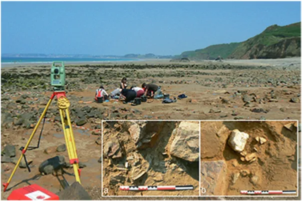
The Palaeolithic site of Les Vallées is an open-air site located in the intertidal zone today (Fig. 12.10). Originally, it was located near a small stream at a time when sea level was 60 m bpsl (below present sea level) and the coastline was approximately 60 km further out (Laforge
2012). On geological grounds, the archaeological material is associated with a cold period earlier than the Last Interglacial, most likely the Saalian glaciation (MIS 6), confirmed by ESR and U/Th dates on bone giving an average age of 164 ± 13 ka (Bahain et al. 2012).
The material indicates a workshop linked with butchery activities and yielded some 2500 arte-facts made on flint and quartz with numerous
fau-nal remains dominated by horse, bison or aurochs and deer (Huet 2010). The artefacts were made by a recurrent knapping technique, with side scrapers of various types, Mousterian points and denticulates. Mammoth remains were discovered at this site at the beginning of the last century.
12.4.3 Fermanville/Biéroc – La Mondrée (Manche-France)
The site of La Mondrée in Fermanville lies at a depth of about 20 m bpsl and was first investi-gated during the 1970s, when it yielded an abun-dant Middle Palaeolithic assemblage of c. 2500 worked pieces (Fig. 12.11; Scuvée and Vérague
1988), with subsequent recovery of an equine tooth and two other bone fragments, one probably from an aurochs. New investigations from 2000 to 2002 by diver survey and again in 2010 were
Fig. 12.8 Sea-level variations along the French Mediterranean coast during the Holocene. After Stéphan and Goslin
able to locate the original site, to examine the geomorphology of the cliff below which the site is found and to take core and bulk samples for stratigraphic, sedimentological, palynological and geochronological (OSL) analysis (Cliquet et al. 2011).
The 2002 survey revealed at least two occu-pation levels in situ. Pollen data indicate a date of MIS 5a, and OSL dating produced consistent results of c. 70 ka, corresponding to the bound-ary between MIS 5 and MIS 4 (Mercier et al.
2013). The stone assemblage is a Mousterian industry with scrapers and notched pieces; bovid
and deer bones were also recovered and evidence of knapping areas and hearths (Coutard and Cliquet 2005). At the time of its occupation, the site was situated at the foot of a cliff looking out over a narrow coastal plain at the mouth of a small valley that gives access to an extensive pla-teau in the hinterland. The shoreline was perhaps no more than a few kilometres. This location would have provided shelter, large nodules of Cretaceous flint exposed during periods when sea level was lower than present and easy access to animal herds and to marine resources at the shore edge. Around 10.000 cal. BP Rela ve sea-level : -40 m Around 8.000 BP Rela ve sea-level : -15 m Around 6.000 BP Rela ve sea-level : -5,2 m Around 4.000 BP Rela ve sea-level : -3 m Coastal plain landscape Separa on to the mainland Fragmenta on Reduc on of island surfaces MESOLITHIC MESOLITHIC MID-NEOLITHIC
EARLY BRONZE AGE 1 km 1 km 1 km 1 km Iroise sea Iroise sea SEQUENCES OF PALAEOGEOGRAPHIC EVOLUTION below sea-level above sea-level foreshore zone 0 20 40 60 80 100 100 80 140 120 60 40 20 m
12.4.4 North Sea, Channel and Atlantic Finds
Since the middle of the nineteenth century, geol-ogists have retrieved mammal bones from the bed of the North Sea. Trawler fishing in the Pas de Calais Strait has produced many bones, of which only the more spectacular have been reported such as mammoth teeth and tusks and bovid bones. Similar finds have been reported offshore of the Boulogne coast (Sauvage 1899) and from the Channel and Atlantic coasts.
The beaches of Le Havre are famous for their large Palaeolithic assemblages associated with fauna (Babeau 1906; Romain 1915). At −2 m ODN (Ordnance Datum Newlyn; equivalent to mean tide level), the flint industry of the Station Romain includes bifaces and flakes linked to the MIS 7 interglacial. A rich fauna testifies to tem-perate environments (wild boar, roe deer, straight-
tusked elephant [Palaeoloxodon antiquus]) and glacial environments (horse, mammoth, bison, reindeer).
There are numerous finds of Pleistocene fauna off the Normandy coast, particularly along the edges of the Seine palaeo-valley (Auguste, forth-coming). Mammoth remains (Mammuthus primi-genius) have been found offshore of Barfleur (Manche) at a depth of 30 m (unpublished); at Courseulles-sur-Mer, Graye-sur-Mer, Luc-sur- Mer, Port-en-Bessin and Villers-sur-Mer (Calvados); and at Cauville-sur-Mer, Saint-Jouin and Saint-Valéry-en-Caux (Seine-Maritime), the latter at a depth of 20 fathoms (Mercier 1934). Offshore of Barfleur, a horse tooth has been trawled at a depth of 20 m (unpublished). At Saint-Aubin-sur-Mer, on the Câtel beach (Calvados), mammoth and rhinoceros bones have been reported. At Saint-Côme-de-Fresné/Asnelles Belle-Plage (Calvados), the Eemian beach is
cov-Fig. 12.10 The Middle Palaeolithic site of Les Vallées during excavation: (a) faunal remains and quartz flakes; (b)
ered by peat and green clay of glacial age, in which faunal remains have been recovered as well as some flint tools (Guillaume 1935, 1952).
On the beaches of Brétignolles-sur-Mer (Vendée) particularly at Le Lac and Le Marais Girard, Elephas antiquus remains were found beneath a peat deposit lying on an Eemian con-glomerate, apparently associated with some small pebble tools (Fig. 12.12; Labrude et al.
2000; Pouit and Viaud 2002). Full details have not been published, apart from a pollen analysis (Bernard and Visset 1992), which suggests an interglacial age, most probably MIS 5 e (Eemian).
12.4.5 Ault-Onival (Somme)
The site of the Ault-Onival beach, on the south shoreline of the Somme estuary, was discovered at the beginning of the twentieth century, and more recently an important assemblage of flint cores, Levallois flakes and proboscidian bones was collected from low in the intertidal zone (Fig. 12.13; Agache 1968; Auguste, 2009; Antoine et al. 2011). The site is dated to the early Pleniglacial or the beginning of the middle Pleniglacial (MIS 4 or the MIS 3–4 transition), based on sedimentary features and an ESR/Uth date (55 ± 10 ka) on a horse tooth, and this is
Fig. 12.11 The Fermanville La Mondrée site. Bones of aurochs (top) and deer (middle) picked up from the eroding
surface of the site and fragments of an equid tooth (bottom) found in situ. Their deteriorated surfaces are due to biologi-cal decomposition. Photo by Dominique Cliquet
Fig. 12.12 La Parée beach in Brétignolles-sur-Mer (Vendée): Elephas antiquus remains in situ
Fig. 12.13 Surveys by R. Agache on the Middle Palaeolithic site of Ault-Onival (Somme). Photo by DRAC Hauts de
consistent with the palaeontological data, mainly horse and Mammuthus primigenius (Auguste
2009; Antoine et al. 2011). The technological features of the industry and the position of the site indicate flint knapping activities near a source of raw material (Perpère 1986, 1999). The sedi-mentary origin of the deposit, as well as its situa-tion under an ancient sea cliff created by coastal erosion, offers parallels with the section of the Sangatte fossil cliff, where dates of MIS 7 dem-onstrate that the Strait of Dover was open as a sea channel by that time (Antoine 1989; Balescu et al. 1992).
12.4.6 South-West France
No Pleistocene or Palaeolithic finds have been recovered along the coast of Aquitaine, but recent palaeoenvironmental research and archaeological survey in the hinterland raise questions about the environments available on the now-submerged coastal shelf. In the Landes triangle of the Aquitaine region of SW France, there existed an arid ‘desert’ during the Last Glacial Maximum (MIS 2), where coversands extended over a large area of low relief in the hinterland, exposed to winds and with little surface water, creating an inhospitable environment for human settlement, and a cultural barrier between the Pyrenees and Cantabria to the south and the Charente and the Périgord to the east and the north (Bertran et al.
2013). New studies of lithic technology and raw materials suggest that, despite this barrier, circu-lation of materials and movements of people per-sisted between the adjacent regions and that this may have taken place along the coastline of the submerged shelf, which extends for 50–100 km offshore from the present coastline. This hypoth-esis highlights the potential human significance of the submerged shelf and the need for offshore palaeoenvironmental studies, and ultimately the search for archaeological remains, to further explore this potential.
12.4.7 The Mediterranean Coastal Karst
The French Mediterranean coastline includes the following karstic massifs, from west to east (Fig. 12.6; Billaud 2017):
• Perpignan to Narbonne: the end of the Corbières massif and the massif of La Clape. • Sète to Montpellier: the Gardiole mountain
and the border of the Cévennes.
• East of Marseilles to Toulon: the Couronne Massif and the Calanques.
• Antibes to the Italian frontier: the Préalpes of Grasse and of Nice.
The cave openings in these karstic environ-ments have trapped sedienviron-ments containing a vari-ety of information about Quaternary human occupation and environment particularly over the last glacio-eustatic cycle (Billaud et al. 2014; Billaud 2017).
Underwater archaeological studies of these submerged karstic openings are still few in num-ber. Apart from the recent operations in the Cosquer Cave (described below), there is older research conducted from 1968 to 1976 by DRASSM (Département des Recherches Archéologiques Sub-aquatiques et Sous- Marines), mainly focussed on the Calanques Marseillaises area and the Villefranche Bay fur-ther east (Bonifay 1970, 1973; Bonifay and Courtin 1998). In the Calanques, this research identified a dozen caves, but only four have been investigated in detail. One of them contains bone breccias, and Palaeolithic artefacts were discov-ered at another (Bonifay and Courtin 1998).
In the Couronne Massif, few cavities are men-tioned apart from the Caves of the Mona au Rouet and the three Cap Méjean caves (Bonifay and Courtin 1998, fig. 2), which are openings at a depth of 15–20 m bpsl. Two of these are complex networks only partly explored. One contains cemented deposits which have yielded
micro-fauna (Courtin 1978, p. 738). In the Var depart-ment, cavities are also mentioned east of La Ciotat (Courtin 1978). They are situated at a depth of 10–15 m bpsl and contain cemented deposits.
Information about the archaeology of these underwater karsts is uneven because, apart from the Cosquer Cave, they have often been explored for speleological or hydrological purposes rather than archaeological. Nevertheless, the available information indicates the presence of Pleistocene sedimentary sequences and remains of human activity and fauna, suggesting considerable potential for future research.
12.4.8 The Cosquer Cave
In 1991, the discovery of the Cosquer Cave, located on the coast near Cassis east of Marseille, revealed the only Palaeolithic painted cave known to this day east of the River Rhone. This resulted in renewed interest in the detailed study of regional karst and in the reconstruction of sea- level rise after the last glaciation. The Cosquer Cave has been visited by divers since 1984, but its archaeological significance was only formally recorded in 1991 (Clottes et al. 2005; Vanrell
2010). This cavity is presently accessible to div-ers by an opening at a depth of 37 m bpsl which leads upwards through a narrow gallery to a par-tially flooded chamber (Fig. 12.14). The original
entrance was closed by sea-level rise after the Last Glacial Maximum. However, the water level in the cave is slightly lower than that of the Mediterranean Sea. The emerged part of the cave has provided a rich collection of art, with a total of 188 animal figures (11 species identified, some of which are marine species, including 9 seals, 4 fish and 3 auks), 71 negative handprints and nearly 300 symbolic representations (Fig. 12.15). There are numerous traces of past human activ-ity—handprints, charcoal, hearths and broken concretions. Radiocarbon dates place the occupa-tion between 29,000 and 17,500 BP (Early Gravettian to Epigravettian).
12.5 Later Prehistoric Finds
12.5.1 Intertidal Settlementsand Peat Deposits
Ancient peat deposits are exposed at low tide along many shorelines and extend to the subtidal zone. They bear witness to the extension of back- barrier marshes before the end of postglacial sea- level rise.
On the shorelines of Picardie and Boulonnais, low, sandy beaches alternate with rocky head-lands, with offshore gravel barriers or bay-mouth bars. On the sandy beaches, peat deposits exposed by marine erosion provide radiocarbon dates between 5700 BP, as in the Canche tidal creek in
100 m 50 10 0 Chimney - 0 - 21 Big shaft Bison's fault Chamber 1 Chamber 2 Submerged gallery Porch - 36 South North
Camiers, and 3600 BP, as at Wimereux (Mariette
1971), sometimes associated with lithic artefacts as at Wissant’s Bay (Dutertre 1924, 1925; Briquet
1930), and especially at Tardinghen (Mariette
1971, 1976b; Vallin and Masson 1993).
At Wimereux, the top of the eroded peat yielded flint implements and traces of a hearth (Briquet 1906, 1930; Dutertre 1925, 1930, 1933,
1934; Agache 1968; Mariette 1971). Also, a shell midden was recorded on the edge of the peat where it was covered by humic sands (Munaut and Gilot 1977), and the level beneath provided some sherds attributed to the Middle and Late Neolithic (Mariette 1971, 1976a; Ters 1973).
Similar deposits are present at Hardelot, about 20 km further south (Mariette 1971; Ters
1973; Agache 1968; Bostyn and Vallin 1986), where a Late Neolithic site has been discovered around −2.5 m ODN. Remains of a rectangular
building consisting of wooden poles dug in the peat were observed in the nineteenth century (Ovion 1890).
In Brittany, several Neolithic occupations have been identified in submerged peats: a deer antler industry at La Ville-Berneuf (in Pléneuf- Val- André) (Milon and Giot 1949); the remains of postholes, ditches and varied implement dated to 4000–2500 cal BC at Curnic in Guissény (Giot et al. 1965); and Neolithic polished axes, flint tools and ceramics at the mouth of the Quillimadec River (Kerlouan).
On the right bank of the mouth of the Rance River, the remains of a probable settlement dis-covered at the limit of the present lowest tides yielded two lines of wooden stakes 50 m apart (Langouët 1995; Hénaff et al. 1998), and one of the stakes is dated to 3327–2929 cal BC (Ly- 8830), attributable to the Recent Neolithic.
On the Vendée coastline, numerous peat deposits have been observed since the early twen-tieth century (Welsch 1911, 1917), especially at Brétignolles-sur-Mer, where Early Neolithic material has been recorded at La Parée, −5 and − 6 m ODN, dated at 5207–4458 cal BC, and at La Pointe du Grouin du Cou dated at 5700– 4850 cal BC (Joussaume et al. 1986).
The Charente coastline has a different mor-phology, with a string of islands close offshore, and a continental shelf deeply incised by ancient valleys (Laporte 1998, 2009). There are rare dis-coveries of the 5th or early 4th millennium (cal. BC), notably the Early Neolithic remains at the Bois-en-Ré beach (Pautreau and Robert 1980) and a Middle Neolithic shell midden (Rousseau et al. 2001). Remains belonging to the later 4th and 3rd millennium are more abundant, reflecting the stabilisation of the shoreline at its present position. Submerged peats on the west coast of Oléron Island facing the mainland have produced many Late Neolithic finds (Welsch 1917; Burnez and Morel 1965; Gabet 1973; Laporte and Glausinger 1986; Laporte et al. 1998; Laporte
2009). At La Pointe d’Ors, there are the remains of a probable domestic stone building within archaeological levels accessible only at low tide (Luguet 1867; Pineau 1891; Boisselier 1893; Dulioust 1958; Gabet 1968; Rouvreau 1968; Rouvreau and Gomez 1973; Joussaume 1981; Cassen 1987; Laporte et al. 1995). These deposits have yielded some wooden artefacts, including examples of stone axes in wooden handles, and
similar artefacts are reported on the opposite side of the same bay at Piédemont (Gabet and David
1975).
12.5.2 Megalithic Sites 12.5.2.1 Neolithic Tombs
Several passage graves are located at about mean tide level on the Channel coast. These are typi-cally dated to about 5100 cal BP but may have continued in use until around 4000 cal BP (L’Helgouach 1965; Giot 1958, 1968; Giot and Morzadec 1992). The position of these monu-ments ranges between 0 m ODN (i.e., +5,27 m above low tide) and − 7 m ODN. Because of the tidal range, these monuments are regularly sub-merged, in some cases at every high tide, as with the Kernic passage grave at Plouescat (Fig. 12.16). This monument is probably one of the most famous on the northern coast of Brittany. Classified as a ‘monument historique’, it was excavated in 1983 and 1984 because of the effects of shoreline erosion and was then restored (Lecerf
1985).
On the shore, to the south of Coalen Island (Lanmodez, Côtes-d’Armor), there is a damaged passage grave, which has lost its capstones (Fig. 12.16). Open to the south, the monument is reached during higher tides. It is 7.2 m long and 1.4 m wide and still has 3 standing stones on the west side and 6 on the east. To the north, an iso-lated half block constitutes perhaps one of the
Fig. 12.16 Partially submerged passage graves on the seashore. Left: Kernic, Plouescat (Finistère); Right: Coalen
sides of a terminal chamber (‘cella’), and scat-tered blocks may be the remains of the surround-ing structure (Giot 1971).
In the channel between Rovarc’h and Garec’h- Vari islands (Penvenan, Côtes-d’Armor), a collapsed dolmen stands on the shore of Pellinec. In the 1930s, a flagstone mea-suring 1.80 × 1.60 m and 5 supports lying on the ground could still be seen (Mazères and de Bellaing 1936). In the same commune, the chan-nel of Saint-Gildas island (Penvenan) presents on its south side an eroded and collapsed dol-men, which was still visible at the beginning of the 1930s (Mazères and de Bellaing 1936). In the 1980s, only some scattered blocks remained (Daire, personal observation).
On the north bank of Tresseny Bay, there is a probable passage grave at Lerret in Kerlouan, submerged at each high tide, though much dam-aged. The monument as a whole, the northern side of which is well preserved, is 23 m long (L’Helgouach 1965; Sparfel and Pailler dir. 2009, pp. 100–101). At Le Conquet on the northern point of Finistère, around forty flagstones indi-cating a likely collapsed passage grave are visible at low tide on the beach of Les Blancs Sablons (Sparfel and Pailler dir. 2009, p. 175). Four of them are oriented in the same direction, forming a passage with an internal width of 1.7 m.
East of Noirmoutier Island (Vendée), the stone called ‘La Table’ is the only remnant of a dolmen (Large et al. 2015).
12.5.2.2 Standing Stones
and Megalithic Complexes
In several places in Brittany, submerged standing stones mark the seashore and are important amongst other reasons because they are evidence of Holocene marine transgression. In many cases, these stones appear in isolation—all that is left of the original monument complex—but sometimes sufficient numbers are present to indicate a circu-lar layout.
At Côte des Abers (Finistère), several mega-lithic monuments on the seashore include the 2.5-m high-standing stone of Saint-Cava Bay in Plouguerneau, called Men Ozac’h (Devoir 1912). Before being moved, it was submerged for half the tidal cycle with the base lying 2 m above present mean sea level (Fig. 12.17). This standing stone was associated with the remains of a rect-angular enclosure of smaller blocks.
On the south coast of Finistère, the standing stone of Penglaouïc (Loctudy), in the Pont- L’Abbé river, is partly submerged at high tide. It is one of a series of megaliths placed at the mouth of waterways or streams, notably at Lesconil (Fig. 12.17), Léchiagat and Lespurit en Plovan.
Other examples are the large menhir currently lying on the ground on the south of Groix Island in Locmaria Bay, some dozens of metres offshore from the present coastline (López-Romero et al.
2008), and in Brittany, the standing stones of La Pointe du Chevet at Saint-Jacut-de-la-Mer (Côtes-d’Armor) (Langouët 2003) and
Fig. 12.17 Left: Menhirs on the Finistère coast. Left: Men Ozarc’h at Plouguerneau. Right: Lesconil. Photos courtesy
Trébeurden, located between Grande Island and Milliau Island (Marchat and Le Brozec 1991).
12.5.2.3 Stone Rows and Megalithic Enclosures
Several partly submerged standing stones have recently been discovered and studied in Morbihan, especially on the seashore of the Quiberon Peninsula, such as the Kerdual align-ment, preserved between Carnac and La Trinité- sur- Mer, and the Kerpenhir site (Locmariaquer). Highlighted by Z. Le Rouzic (1965), a set of submerged blocks has long been seen extending into the sea at low tide, a prolongation of the Le Moulin alignments (Saint-Pierre-Quiberon). These include more than a dozen parallel lines of standing stones about 400 m long, associated with a megalithic enclosure (2 large stelae are still visible) and a burial mound. Mapping of the rocky Kerbougnec platform also led to the discovery
of a subtidal structure comprising 150 partly submerged monoliths (Cassen et al. 2011).
At Le Petit-Rohu in Quiberon, two pairs of polished axe blades made from Alpine rock embedded in the mud of the foreshore were discovered by holidaymakers in August 2007 at Porh Fetan (Fig. 12.18; Cassen et al. 2008). Further to this discovery, excavations revealed animal footprints, plough marks and a set of 45 collapsed flagstones, which appear to have formed a NNE–SSW alignment. Some of these are visible on the shore at low spring tide, and others are permanently submerged in 5–6 m water. There are numerous other stone rows of similar type in the same area, such as Kerbougnec, which are now submerged in more than 5 m of water. The environmental context shows that the axe blades associated with the Petit-Rohu mono-liths were buried in wetlands behind a sandy bar-rier at the foot of a prominent rocky outcrop. The coastline would have been about 500 m distant at
0 10 cm N N N° 1 N° 2 N° 3 N° 4 N° 5 0 10 cm
Jadeitite axe hoard
Jadeitite axe hoard
Stele Layer of peat Fibrolitite axe
Fibrolitite axe
Fig. 12.18 Rows of stelae discovered at low tide on the intertidal platform of Le Rohu in Saint-Pierre-Quiberon and a
the time when these artefacts were deposited, estimated on archaeological grounds as the mid- 5th millennium cal BC (Cassen et al. 2010).
At the heart of the Morbihan Gulf is the famous double megalithic enclosure of Er Lannic, long recognised as evidence of a Holocene marine transgression (Closmadeuc 1882). Erected around 6000 cal BP, this consists of 49 menhirs, of which 33 are covered at high tide (Gouezin 1998). They form two adjacent horseshoe- shaped enclosures, with a menhir, larger than the others, standing at the point where they meet (Fig. 12.19).
Finally, a cromlech (circle of standing stones) occurs on the Chausey archipelago (Manche). The archipelago was separated from the main-land about 5000–4000 cal BC by a shallow (c. 20-m deep) sea crossing of 14 km. The tidal range in this area is 15 m, and at low tide near the Oeillet inlet, there is a rocky seashore with the cromlech located at around −0.2 m ODN (Fig. 12.19; Chancerel et al. 1994, 1998). This circle (a little flattened) is composed of large granite boulders, of which only five are still in their vertical position. Inside the circle, there is an oval-shaped stone-lined hearth 1.25 m long. Around 600 flint artefacts recovered from the site confirm a Neolithic date. There are also several stone dikes related to the cromlech, which could be contemporaneous with it.
12.5.3 Coastal Lagoons 12.5.3.1 The Atlantic Coast
The coastal lagoons here are well known for their submerged finds, especially from the proto- historic period in the Sanguinet Lake (Maurin
1998). However, the Aquitaine region also offers evidence of several prehistoric sites around the Arcachon Basin and the ancient mouth of the Leyre River. The Betey site in Andernos-Les- Bains is characterised by numerous discoveries made during pedestrian surveys on the shoreline, but without stratigraphic or chronological con-text (Roussot-Larroque 1997). The subsequent study of the artefacts has indicated four main
occupation phases: Mesolithic and Early, Recent and Late Neolithic.
Excavations associated with new harbour work in the area (carried out jointly by INRAP, DRASSM and Aquitaine SRA) have produced stratified and radiocarbon-dated evidence of Neolithic sherds and lithics as well as sherds of Early Bronze Age II/Middle Bronze Age I, although this material has been subjected to rede-position by fluvial action.
12.5.3.2 The Mediterranean
A number of submerged Neolithic finds have been found in coastal lagoons (Leroy 2001). One of the principal sites is Leucate-Corrège discov-ered by dredging at a depth of −5 m, which includes Early Neolithic material including fish and bird bone, net weights and bone tools (Guilaine et al. 1984). Middle and Late Neolithic settlements have also been recovered at Montpenèdre in Marseillan, in the Thau lagoon, Moutaras at La Grande Motte and Frontignan ‘Les Dunes’ at depths ranging from 0 to −2 m (Montjardin and Cablat 2004) and at Mèze ‘La Conque’. Several Bronze Age sites are present in these coastal contexts, especially in the Thau lagoon (Leroy et al. 2003).
12.5.4 Submerged Fish Weirs
Fish weirs have been systematically studied in Brittany since 2006 (Daire and Langouët 2008; Langouët and Daire 2009; Daire and Langouët
2010; Daire et al. 2013; Gandois and Stéphan
2015; Gandois et al. 2018), and similar invento-ries have begun in the Departments of Manche (Normandy) and Vendée (Pays de Loire) since 2009. To date, in Brittany, more than 750 fish weirs have been identified and characterised by twenty or so variables, such as the type of weir, length and level in relation to tides (Table 12.2). Most, of course, relate to the present position of the shoreline and are relatively late in date.
The oldest wooden fish weirs are located in the Bay of Mont-Saint-Michel at the mouth of the Rance River and are radiocarbon-dated to the
0 10 m E AG J H F D C X Y Z B K N N 0 2 m
Fig. 12.19 Lower: General diagram of the megalithic enclosures of Er Lannic, Morbihan (after P. Gouezin 1998). Upper: The cromlech of L’Oeillet on the Chausey archipelago (Manche). After Chancerel et al. (1994, 1998). Drawing by G Lannuzel
Late Neolithic (Hénaff et al. 1998). Early Bronze Age examples are known at Saint-Jean-le- Thomas and Champeaux (Manche) (Fig. 12.20; Billard et al. 2013a, b; all radiocarbon dates in Billard and Bernard dir. 2016).
In Brittany, the search for ancient stone fish weirs, principally conducted from aerial photos of the shore at low tide, has led to the identifica-tion of fish weirs under 3–4 m of water. Similar submerged examples have also been observed along the coasts of Vendée and Normandy, four
sites and 11 sites, respectively (Fig. 12.21; Large et al. 2009; Billard et al. 2016).
Dating of stone fish weirs is a problem, but a broad dating scheme is possible by relating the position of the weirs to present-day tidal level with reference to the Holocene sea-level curve of the region (Daire and Langouët 2010, 2011, Daire et al. 2013). Those that are permanently submerged must have been built when relative sea level was lower than present and can be attrib-uted to the Mesolithic or Neolithic period. In
Table 12.2 Inventory of fish weirs of all periods in Brittany, from the database ‘Pêcheries d’Estran de Bretagne’, 2017
Côtes-
d’Armor Finistère Morbihan Ille-et- Vilaine
Brittany Total
Fish weirs of all types and periods 304 246 121 84 755
Wooden fish weirs of all periods 45 3 14 60 122
Stone fish weirs of all periods 239 226 82 23 570
Stone fish weirs below the level of the lowest spring tide (% of all stone fish weirs in parentheses)
5 (2.1) 66 (29.2) 10 (12.2) 2 (8.7) 83 (14.6)
This database is in progress and is not yet published. It includes additional finds of fish weirs, listed in this table, but these are not included in Table 12.1
Fig. 12.20 Footprints at Saint-Jean-le-Thomas (Manche). They are associated with the remains of a wooden fish weir
Brittany, 83 of these have been identified, 14.6% of all known stone fish weirs in the region (Table 12.2). The majority are located on the channel coasts of Finistère, Côtes d’Armor and Ille et Vilaine, with far fewer on the Atlantic coastlines. The oldest, judging by their depth at c. 5 m below the spring tide level, are at Lag Karreg (Brignogan) and Telleskog (Kerlouan) in Finistère.
In some areas, ‘horizontal stratigraphies’ can be observed, that is, shifts in the position of fish weirs to accommodate the rise in sea level. At Santec, three fish weirs are located at progres-sively shallower depths from −6.8 m to −2.6 m along a submerged valley channelled between rocky outcrops (Fig. 12.22; Roué and Le Goff
2008, p. 105). In the same way, at Saint-Jean-de- la-Rivière (Manche), six stone fish weirs form a
Fig. 12.21 Submerged complex of fish weirs at Le Tambourin, Noirmoutier Island (Vendée). Photo by Patrice
Birocheau, 2009
Fig. 12.22 Three submerged fish weirs at Santec (Finistère). They are built across a submarine channel delimited by
the rocks marked Melenn et Pereg ar Bagou and form a sequence at progressively shallower depths (7 is deepest, 3 is shallowest), illustrating the adaptation of the fish weir builders to progressive sea level rise. Photo by Ortholittorale 2000; drawing by Loïc Langouët
sequence of successively shallower structures across a marine channel, the lowest being fully subtidal and the highest being located close to the neap tide level.
It is probable that many more submerged stone fish weirs remain to be discovered on other coastlines, and surveys are only just beginning, as, for example, at L’Acheneau (Vendée), where the fish weir is submerged at −3 to −9 m (Fig. 12.23; Ydier and De Maisonneuve 2012), and in the Molène archipelago (Gandois et al.
2013a, b).
12.6 Scientific Challenges
and Future Prospects
Prehistoric occupations have left significant traces in the intertidal zone and on the seabed, but until recently in France, as in many European
countries, maritime archaeology has principally involved the study of ships and maritime trade. However, archaeological investigations along the coastline have successfully confirmed the high potential and good preservation of submerged sites, including organic artefacts such as wooden objects, features related to fishing and faunal assemblages. New types of sites and new prob-lems have emerged in the past decade. The poten-tial for the investigation of submerged Palaeolithic sites is highlighted by the Fermanville ‘La Mondrée’ site and the famous Cosquer Cave. The study of megalithic complexes needs to be extended offshore to obtain a more complete pic-ture, and fish weirs are producing an unexpect-edly abundant and informative indicator of widespread and intensive activity along the Atlantic and Channel coastlines. In many areas of western France, submerged coastal sites repre-sent one of the principal ways to obtain tree ring
series for the construction of dendrochronologi-cal reference curves.
Little work has been carried out so far on high-resolution mapping of submerged land-scapes, and this should be a priority for the future. Bathymetric lidar, in particular, offers interesting prospects for surveys in shallow water. Other priorities are the integration of palaeoenvironmental studies with archaeologi-cal survey, particularly in relation to the Pleistocene, and the training of divers who combine diving qualifications with a knowl-edge of prehistoric archaeology. The imple-mentation of a genuine scientific programme relating to all these issues is all the more urgent in that offshore industrial projects, including wind farms, the quarrying of marine aggregates and the expansion of port areas, are rapidly increasing along the French coastline.
12.7 Management
of the Underwater Cultural
Heritage
The underwater heritage has been the responsi-bility of DRASSM (Département des Recherches Archéologiques Subaquatiques et Sous-marines) since 1966. This is a national government agency under the ministry in charge of culture and is based at Marseille. It is responsible for the imple-mentation of legislation relating to all aspects of maritime cultural heritage including prehistoric, archaeological and historical information, with particular reference to the intertidal area and the seabed within the French exclusive economic zone, especially since the ratification by France in 2013 of the 2001 UNESCO Convention. DRASSM registers sites and directs the study and excavation of submarine archaeological sites in France and overseas. It includes freshwater contexts within its remit and is concerned with the evaluation and study of sites as varied as ship-wrecks, prehistoric lacustrine dwellings, river installations and submerged caves.
References
Agache R (1968) Informations archéologiques, circon-scription de Nord et Picardie. Gallia-Préhistoire 9(2):267–309
Antoine P (1989) Stratigraphie des formations pléis-tocènes de Sangatte (Pas-de-Calais), d’après les pre-miers travaux du tunnel sous la Manche. Bulletin de l’Association Française pour l’Etude du. Quaternaire 37:5–17
Antoine P, Auguste P, Bahain JJ, Louguet S (2011) Datation et reconstitution paléoenvironnementale d’un site paléolithique moyen submergé en Manche Est: Ault-Onival (Somme, France). Quaternaire 22(3):221–233
Auguste P (2009) Evolution des peuplements mammali-ens en Europe du Nord-Ouest durant le Pléistocène moyen et supérieur. Le cas de la France septentrionale. Quaternaire 20(4):527–550
Babeau L (1906) La préhistoire et la plage sous-marine du Havre. Bulletin de la Société Géologique de Normandie 26:37–45
Bahain JJ, Flaguières C, Laurent M, Shao Q, Dolo JM, Garcia T, Douville E, Frank N, Monnier JL, Hallegouet B, Laforge M, Huet B, Auguste P, Serre F, Gangnepain J (2012) ESR and ESR/U-series dating study of the Middle Paleolithic site of Piégu (Brittany, France) – a multi-material approach. Quat Geochronol 10:424–429
Balescu S, Packman SC, Wintle AG, Grün R (1992) Thermoluminescence dating of the middle Pleistocene raised beach of Sangatte (Northern France). Quat Res 37(3):390–396
Bernard J, Visset L (1992) Une tourbière interglaciaire sur la plage de la Parée à Brétignolles (Vendée – France): première approche pollenanalytique. Quaternaire 3:16–22
Bertran P, Sitzia L, Banks WE, Bateman MD, Demars PY, Hernandez M, Lenoir M, Mercier M, Prodeo F (2013) The Landes de Gascogne (Southwest France): perigla-cial desert and cultural frontier during the Palaeolithic. J Archaeol Sci 40(5):2274–2285
Billard C, Bernard V (2016) Pêcheries de Normandie: Archéologie et histoire des pêcheries littorales du département de la Manche. Presses Universitaires de Rennes, collection Archéologie et Culture, Rennes, 717 p
Billard C, Bernard V, Bouffigny A, Clavel B, Couturier Y, Jaouen G, Le Digol Y, Quevillon S, Ropars A (2013a) Techniques et modes d’exploitation des pêcheries sur le littoral normand (France) : un essai de bilan de 10 années de travaux archéologiques. In: Daire MY, Dupont C, Baudry A, Billard C, Large JM, Lespez L, Normand E, Scarre C (eds) Ancient maritime com-munities and the relationship between people and environment along the European Atlantic coasts.
Proceedings of the HOMER 2011 conference, Vannes, 28 septembre-1er octobre 2011, British archaeologi-cal reports international series 2570. Archaeopress, Oxford, pp 139–149
Billard C, Bernard V, Quevillon S (2013b) Potentiel et méthodes d’approche des pêcheries littorales de Basse-Normandie (France). In: Daire MY, Dupont C, Baudry A, Billard C, Large JM, Lespez L, Normand E, Scarre C (eds) Ancient maritime communities and the relationship between people and environment along the European Atlantic coasts. Proceedings of the HOMER 2011 conference, Vannes, 28 septembre-1er octobre 2011, British archaeological reports interna-tional series 2570. Archaeopress, Oxford, pp 3–11 Billard C, Daire MY, Martin C, Billaud Y, Bizien-Jaglin
C, Chancerel A, Cliquet D, Fourment N, Gandois H, Huet B, Laforge M, Langouët L, Laporte L, Large JM, Leroy F, López-Romero E, Monnier JL, Ropars A, Régaldo P, Stéphan P, Vallin L (2016) Un premier inventaire des sites préhistoriques submergés au large des côtes françaises. Bulletin de l’Association Manche Atlantique pour la Recherche Archéologique dans les Iles 29:5–49
Billaud Y (2017) Submerged karst structures of the French Mediterranean coast: an assessment. In: Flemming NC, Harff J, Moura D, Burgess A, Bailey GN (eds) Submerged landscapes of the European con-tinental shelf: Quaternary Paleoenvironments. Wiley, Chichester, pp 333–340
Billaud Y, Chazaly B, Olive M, Vanrell L (2014) Acquisition 3D et documentation multiscalaire de la grotte Cosquer: une réponse aux difficultés d’accès et à une submersion inéluctable? Kartologia 64:7–16 Boisselier A (1893) Le palet de Gargantua et les
oscil-lations du niveau de la mer. Revue des Sciences Naturelles de l’Ouest 3:366–367
Bonifay E (1970) Antiquités archéologiques sous- marines. Gallia Préhistoire 13(2):585–592
Bonifay E (1973) Circonscription des antiquités préhisto-riques sous-marines. Gallia Préhistoire 16(2):525–533 Bonifay E, Courtin J (1998) Les remplissages des grottes
immergées de la région de Marseille. In: Camps G (ed) L’homme préhistorique et la mer, 120e congrès
du commité des travaux historiques et scientifiques, Aix-en-Provence, oct. 1995. Editions du Commité des Travaux Historiques et Scientifques, Paris, pp 11–29 Bostyn F, Vallin L (1986) L’outillage préhistorique en
os du Nord-Pas-de-Calais. Inventaire et aspects tech-niques. Gallia Préhistoire 29(1):193–215
Briquet A (1906) Notes sur quelques formations qua-ternaires du littoral du Pas-de-Calais. Annales de la Société Géologique du Nord 35:211–236
Briquet A (1930) Le littoral du nord de la France et son évolution morphologique. Editions A. Colin, Paris Burnez C, Morel J (1965) Contribution à la connaissance
de la céramique préhistorique de la Saintonge. Bulletin de Société Prehistorique Française 62/63:555–566
Cassen S (1987) Le Centre-Ouest de la France au IVe mil-lénaire, British archaeological reports international series 342. Archaeopress, Oxford
Cassen S, Boujot C, Errera MD, Marguerie D, Menier D, Pailler Y, Pétrequin P, Poirier S, Veyrat E, Vigier E (2008) Discovery of an underwater deposit of Neolithic polished axeheads and a submerged stone alignment at Petit Rohu near Saint-Pierre-Quiberon (Morbihan, France). Antiquity 82, Project Gallery. http://www. antiquity.ac.uk/projgall/cassen316/
Cassen S, Boujot C, Errera MD, Menier D, Pailler Y, Pétrequin P, Marguerie D, Veyrat E, Vigier E, Poirier S, Dagneau C, Degez D, Lorho T, Neveu-Derotrie H, Obeltz C, Scalliet F, Sparfel Y (2010) Un dépôt sous-marin de lames polies néolithiques en jadéitite et sillimanite et un ouvrage de stèles submergé sur la plage dite du Petit Rohu près Saint-Pierre-Quiberon (Morbihan). Bulletin de Société Prehistorique Française 107:53–84
Cassen S, Baltzer A, Lorin A, Fournier J, Sellier D (2011) Submarine Neolithic stone rows near Carnac (Morbihan, France): preliminary results from acous-tic and underwater survey. In: Benjamin J, Bonsall C, Pickard C, Fisher A (eds) Submerged prehistory. Underwater archaeology and the future of submerged European prehistory. Oxbow, Oxford, pp 99–110 Chancerel A, Hérard B, Ghesquière E, Desloges J (1994)
Archipel de Chausey. Rapport de prospection 1994. DRAC service régional de l’archéologie, Caen Chancerel A, Dinard F, Desloges J, Ghesquière E, Hérard
B (1998) Archipel de Chausey (Granville – Manche). Rapport de prospection. Campagne de 1996. DRAC service régional de l’archéologie, Caen
Cliquet D, Coutard S, Clet-Pellerin M, Allix J, Tessier B, Lelong F, Baltzer A, Mear Y, Poizot E, Auguste P, Alix P, Olive J, Guesnon J (2011) The Middle Palaeolithic underwater site of La Mondrée, Normandy, France. In: Benjamin J, Bonsall C, Pickard C, Fisher A (eds) Submerged prehistory. Underwater archaeology and the future of submerged European prehistory. Oxbow, Oxford, pp 111–128
Closmadeuc G (1882) Le cromlech d’Er-Lannic et le Golfe du Morbihan, à l’époque dite celtique. Bulletin de la Société Polymathique du Morbihan 1882:8–24 Clottes J, Courtin J, Vanrell L (2005) Cosquer
redécou-vert. Seuil, Paris
Courtin J (1978) Recherches Archéologiques sous- marines. Gallia Préhistoire 21(2):735–746
Coutard S (2003) Formations quaternaires en bordure d’une mer épicontinentale, la Manche Tectonique, eustatisme, climat et occupations humaines – Exemple du Val de Saire (Normandie, France). Unpublished PhD thesis, Université Caen Normandie, Caen Coutard S, Cliquet D (2005) Chronostratigraphie des
for-mations pléistocènes et peuplement paléolithique en contexte littoral (Val de Saire, Normandie). Bulletin de Société Prehistorique Française 102:477–499
Daire MY, Langouët L (eds) (2008) Les pêcheries de Bretagne; archéologie et Histoire des pêcheries d’estran. Co-édition CeRAA-AMARAI, Les Dossiers du Centre Régional d’Archéologie d’Alet, AE Daire, MY, Langouët, MY (2010) Les anciens pièges à
poissons des côtes de Bretagne, un patrimoine au rythme des marées. Co-édition CeRAA-AMARAI, Les Dossiers du Centre Régional d’Archéologie d’Alet, AG
Daire MY, Langouët L (2011) Dater les anciennes pêcher-ies par les niveaux marins: approches méthodologiques et perspectives géo-archéologiques: le Bas-Léon, nord Finistère, Bretagne. Norois 220:3–25
Daire MY, Langouët L, Maheo M (2013) Une archéologie au rythme des marées: actualité des recherches sur les anciens barrages de pêcheries maritimes en Bretagne (France). In: Daire MY, Dupont C, Baudry A, Billard C, Large JM, Lespez L, Normand E, Scarre C (eds) Ancient maritime communities and the relationship between people and environment along the European Atlantic coasts. Proceedings of the HOMER 2011 conference, Vannes, British archaeological reports international series 2570. Archaeopress, Oxford, pp 151–162
Devoir A (1912) Témoins mégalithiques des variations des lignes de rivages armoricains. Bulletin de la Société Archéologique du Finistère 39:220–239
Dréano Y, Gandois H, Pailler Y (2013) L’exploitation des poissons dans l’archipel de Molène (Finistère, France) du Néolithique récent à l’Âge du Bronze ancien. In: Daire MY, Dupont C, Baudry A, Billard C, Large JM, Lespez L, Normand E, Scarre C (eds) Ancient mari-time communities and the relationship between people and environment along the European Atlantic coasts. Proceedings of the HOMER 2011 conference, Vannes, British archaeological reports international series 2570. Archaeopress, Oxford, pp 447–458
Dulioust JP (1958) La station d’Ors. Bulletin de la Société Préhistorique Française 55(5/6):262–263
Dutertre AP (1924) Observations sur les formations qua-ternaires et récentes du Boulonnais. Annales du Musée géologique du Boulonnais 1(4):3–13
Dutertre AP (1925) Notice géologique sur la Pointe aux Oies et les abords de la station zoologique de Wimereux. Travaux de la Station Zoologique de Wimereux 9:66–88
Dutertre AP (1930) Trouvailles dans la tourbe submergée de la Pointe-aux-Oies, près Wimereux (Boulonnais). Annales de la Société Géologique du Nord 55:19–21 Dutertre AP (1933) L’industrie et la faune de la tourbe
submergée du rivage du Boulonnais (Note prélimi-naire). Bulletin de la Société Préhistorique Française 30(11):587–588
Dutertre AP (1934) Notice archéologique sur la tourbe submergée de la Pointe-aux-Oies à Wimereux (Pas-de- Calais). Bulletin de la Société Préhistorique Française 31(7/8):352–359
Facon R (1967) Présence du Moustérien moyen, type La Quina à l’Île Madame (Charente-Maritime). Bulletin de la Société Préhistorique Française 64:275–278
Farr RH, Momber G, Satchell J, Flemming NC (2017) Paleolandscapes of the Celtic Sea and the Channel/ La Manche. In: Flemming NC, Harff J, Moura D, Burgess A, Bailey GN (eds) Submerged landscapes of the European continental shelf: Quaternary Paleoenvironments. Wiley, Chichester, pp 211–239 Fridman R (1957) Généralités sur des phénomènes
périglaciaires würmiens sur le littoral et les îles de la Charente-maritime. Bulletin de la Société Géographique de Rochefort 7:585–596
Gabet C (1968) Habitat néolithique d’Ors. Bulletin de la Société de Géographie de Rochefort, 2e série, 4 Gabet C (1973) Le Banc de Tourbe sur l’estran de la baie
de La Perroche (île d’Oléron). Bulletin de la Société Archéologique et Historique de la Charente Maritime 25:297–307
Gabet C, David P (1975) Le gisement de Piédemont (Commune de Port-des-Barques). Rapport prélimi-naire. Roccafortis 2e série, III 6:177–193
Gandois H, Stéphan P (2015) Les barrages de pêcher-ies de l’archipel de Molène (mer d’Iroise, Finistère). Bulletin de l’Association Manche Atlantique pour la Recherche Archéologique dans les Îles 28:45–76 Gandois H (dir.), Stéphan P, Cuisnier D, Gladu Y,
Lallement F, Priol H (2013a) Rapport sur les prospections sous-marines et la zone d’estran en mer d’Iroise, Opération n°OA-1746. DRASSM, SRA Bretagne
Gandois H, Pailler Y, Stéphan Y, Nicolas C (2013b) L’érosion marine et ses effets sur les vestiges archéologiques en mer d’Iroise: exemple de l’impact de la tempête de mars 2008 sur l’île Kemenez et ses Ledenez (Le Conquet, Finistère, France). In: Daire MY, Dupont C, Baudry A, Billard C, Large JM, Lespez L, Normand E, Scarre C (eds) Ancient maritime communities and the relationship between people and environment along the European Atlantic coasts. Proceedings of the HOMER 2011 conference, Vannes, British archaeological reports international series 2570. Archaeopress, Oxford, pp 99–110
Gandois H, Stéphan P, Cuisnier D, Hulot O, Ehrhold A, Paul M, Le Dantec N, Franzetti M (2018) The stone tidal fish weirs of the Molène archipelago (Iroise Sea, Brittany, Western France): a long-term tradition start-ing with early megalithic constructions. Int J Naut Archaeol 47(1):5–27
Giot PR (1958) Kernic, Plouescat. Gallia Préhistoire 1(1):129
Giot PR (1968) La Bretagne au péril des mers holocènes. In: La Préhistoire, problèmes et tendances. CNRS, Paris, pp 203–208
Giot PR (1971) Lanmodez, île Coalen. Gallia Préhistoire 14:341
Giot PR, Morzadec H (1992) Des dolmens à couloirs au péril des mers actuelles. Revue Archéologique de l’Ouest 9:57–66
Giot PR, Hallegouët B, Briard G (1965) Le site du Curnic en Guissény (Finistère). Annales de Bretagne 72(1):49–70
Giot PR, Hallegouët B, Monnier JL (1973) Le Paléolithique ancien du Pays de Léon. Finistère L’Anthropologie 77:497–518
Goslin J, Van Vliet-Lanoë B, Spada G, Bradley S, Tarasov L, Neill S, Suanez S (2015) A new Holocene relative sea-level curve for western Brittany (France): insights on isostatic dynamics along the Atlantic coasts of North-Western Europe. Quat Sci Rev 129:341–365 Gouezin P (1998) Le site mégalithique d’Er Lannic.
Editions de l’Association Archéo Douar Mor, Vannes Guilaine J, Freises A, Montjardin R (1984) Leucate-
Corrège, habitat noyé du Néolithique ancien car-dial. Archives d’Ecologie Préhistorique. Centre d’anthropologie des sociétés rurales, Toulouse, musée Paul Valéry, Sète
Guillaume L (1935) Observations sur les dépôts quater-naires de Saint-Côme-de-Fresné et Asnelles-Belle- Plage (Calvados). Bulletin de la Société Linéenne de Normandie 8(8):63–72
Guillaume L (1952) Les formations quaternaires de la plage du débarquement britannique de Saint-Côme de Fresné-Asnelles Belle Plage (Calvados). In: Shackleton RM (ed) Part XIII. Proceedings of section M. Other subjects, international geological congress, report of the eighteenth session, Great Britain, 1948, London, pp 105–113
Harff J, Flemming NC, Groh A, Hünicke B, Lericolais G, Meschede M, Rosentau A, Sakellariou D, Uścinowicz S, Zhang W, Zorita E (2017) Sea level and climate. In: Flemming NC, Harff J, Moura D, Burgess A, Bailey GN (eds) Submerged landscapes of the European con-tinental shelf: quaternary paleoenvironments. John Wiley & Sons, Chichester, pp11–49
Hénaff X, Langouët L, Meury JL (1998) Des structures néolithiques en bois dans l’anse du Rosais à Saint- Malo (35), suite. Bulletin de l’Association Manche Atlantique pour la Recherche Archéologique dans les Îles 11:5–11
Hinout J, Rolland C (1960) Gisements côtiers de Saint- Trojan. Bulletin de la Société Préhistorique Française 57(5/6):27
Huet B (2002) Une industrie à composante lithologique mixte: le gisement paléolithique moyen de Goaréva (île de Bréhat, Côtes-d’Armor). Bulletin de la Société Préhistorique Française 99:699–716
Huet B (2006) De l’influence des matières premières lithiques sur les comportements techno-économiques au Paléolithique moyen: l’exemple du Massif armoric-ain (France). Unpublished PhD thesis Université Rennes 1, Rennes
Huet B (ed) (2010) Le site paléolithique moyen des Vallées (Pléneuf-Val-André, Côtes-d’Armor) Rapport de fouille archéologique programmée, DRASSM et SRA Bretagne
Joussaume R (1981) Le Néolithique de l’Aunis et du Poitou occidental dans son cadre atlantique, Rennes, Travaux du Laboratoire d’Anthropologie-Préhistoire- Protohistoire et Quaternaire Armoricains. CNRS, Paris Joussaume R, Boiral M, Ters M (1986) Sites préhisto-riques submergés à La Tranche-sur-Mer (Vendée).
Bulletin de la Société Préhistorique Française 83(11/12):423–435
Labrude C, Large JM, Mangematin J (2000) Le Marais Girard à Brétignolles-sur-Mer (Vendée): une nou-velle approche du site. Bulletin du Groupe Vendéen d’Etudes Préhistoriques 36:13–23
Laforge M (2012) Le cadre chronostratigraphique des peuplements pléistocènes de l’Ouest de la France. Eustatisme, changements climatiques et occupations humaines. Unpublished PhD thesis Université de Rennes 1, Rennes
Laisné G, Vilgrain G (2008) Quand Néandertal occupait le littoral de Portbail (Manche). Rapport PCR “Les Premiers Hommes en Normandie”, septième année Lambeck K, Esat TM, Potter EK (2002) Links between
climate and sea-levels for the past three million years. Nature 419:199–206
Lambeck K, Rouby H, Purcell A, Sun Y, Sambridge M (2014) Sea level and global ice volumes from the last glacial maximum to the Holocene. Proc Natl Acad Sci 111:15296–15303
Langouët L (1995) Des structures néolithiques en bois dans l’anse du Rosais à Saint-Malo (35). Bulletin de l’Association Manche Atlantique pour la Recherche Archéologique dans les Îles 8:27–32
Langouët L (2003) Les menhirs de Saint-Jacut-de-la-Mer. Bulletin de l’Association Manche Atlantique pour la Recherche Archéologique dans les Îles 16:61–65 Langouët L, Daire MY (2009) Ancient maritime fish-traps
of Brittany (France): a reappraisal of the relationship between human and coastal environment during the Holocene. J Marit Archaeol 4(2):131–148
Laporte L (ed) (1998) L’estuaire de la Charente de la Protohistoire au Moyen Age. Document d’Archéologie Française. Editions de la Maison des Sciences de l’Homme, Paris
Laporte L (ed) (2009) Des premiers paysans aux premiers métallurgistes dur la façade atlantique de la France (3500–2000 av. JC). Mémoire XXXIII, Editions de l’Association des Publications Chauvinoises
Laporte L, Glausinger R (1986) Le site de L’Ecuissière à Dolus (île d’Oléron, Charente-Maritime). Groupe Vendéen d’Etudes Préhistoriques, La Roche-sur-Yon, pp 77–88
Laporte L, Regibus JP, Regibus J, Ricou C, Rodien-Laire C (1995) Inventaire archéologique de l’île d’Oléron (17). Bulletin de l’Association Manche Atlantique pour la Recherche Archéologique dans les Îles 8:5–20 Laporte L, Cros JP, Fontugne M, Gebhardt A, Gruet Y,
Marguerie D, Oberlin C (1998) Les occupations néo-lithiques de la côte occidentale de l’île d’Oléron. In: Camps G (ed) L’homme préhistorique et la mer, Actes du 120e Congrès National des Sociétés Savantes, Aix-
en- Provence, 1995. Congrès National des Sociétés Historiques et Scientifiques, Paris, pp 197–238 Large JM, Birocheau P, Corson S, Cousseau F, Large C,
Tortuyaux JP (2009) Une archéologie des pêcheries d’estran. L’anse aux Moines et la Pointe du Vieux Moulin au Château-d’Olonne en Vendée Bulletin du Groupe Vendéen d’Etudes Préhistoriques 45:4–45