HAL Id: dumas-01277799
https://dumas.ccsd.cnrs.fr/dumas-01277799
Submitted on 23 Feb 2016HAL is a multi-disciplinary open access archive for the deposit and dissemination of sci-entific research documents, whether they are pub-lished or not. The documents may come from teaching and research institutions in France or abroad, or from public or private research centers.
L’archive ouverte pluridisciplinaire HAL, est destinée au dépôt et à la diffusion de documents scientifiques de niveau recherche, publiés ou non, émanant des établissements d’enseignement et de recherche français ou étrangers, des laboratoires publics ou privés.
Conflicting land use in and around lake Mburo national
park, Sanga sub-county, Mbarara District
Jim Ayorekire
To cite this version:
Jim Ayorekire. Conflicting land use in and around lake Mburo national park, Sanga sub-county, Mbarara District. Economics and Finance. 1999. �dumas-01277799�
APPENDIXVII
MAKERERE
UNIVERSiTY
K.wipAa t'nd Phonc - Cblcs 'MAKUNIKA
I)EPARTf\ I FN'l' OF GEOGRAPHY
''"U I<Ci ()tr }(t TO WHOM TO CONCERN - I I Date ... Dear S;r, Mr., kxs., 0r., i€is a Master of Arts Land Use and Rural Dev .opment degree student. For the pirposes of fufi.11ing part of the course requirements, the bearer has to submit a researched thesis. Hence the need to collect information/data for his/her thesis. Your assistance in providing him/her with the necessary information will be highly appreciated.
Yours sincerely,
•/ i?1
Dr. Hannington Sengendo, Ag. Head, Geography Department.
CONFLICTING LND USE U AND AROUND LAKE
MBURO NATIONAL PARK, SANGA SUB-
COUNTY, MBARARA DISTRiCT.
AYOREMRE JIM
I ERA
IERAGO4511
tJG]A i.c)T333 . 72
A DISSERTATION SUBMITTED IN PARTIAL FULFILLMENT OF THE REQUIREMENTS FOR THE DEGREE OF MASTER OF
ARTS (LAND USE AND REGIONAL DEVELOPMENT PLANNING) OF MAKERERE UNIVERSITY.
MAY, 1999
i-i
DECLARATION
I, AYOREKIRE JIM,
declare that this work has not been submitted
forthe award of a degree in any university or for publication.
I
E
-üi;iAIY
.--- --I
iii
SUPERVISOR'S APPROVAL
This dissertation which is a result of research carried out by Ayorekire Jim in Sanga sub-county - Mbarara District under my supervision is now, with my final approval, ready for submission for the award of a degree to the Higher Degrees Committee of the Faculty of Arts, Makerere University.
I- SIGNED:....'.
'V
DEDICATION
TO
DAD AND MUM, MR. AND MRS. AYOREKIRE
AND
V TABLE OF CONTENTS DECLARATION ... ii SUPERVISOR'S APPROVAL ... DEDICATION ... iv ACKNOWLEDGEMENT ... ... . xii ABSTRACT ... ... .iv CHAPTER ONE. ... 1 1.0 INTRODUCTION ... I 1.1 GENERAL BACKGROUND TO THE PROBLEM ... .. I 1.2 STATEMENT OF THE PROBLEM ... 3
1.3 SCOPE AND PURPOSE OF THE STUDY ... 4
1.4 SPECIFIC OBJECTIVES ... 5
1.5 HYPOTHESES ... 5
1.6 SIGNIFICANCE OF THE STUDY ... 6
CHAPTER TWO: ... 8
2.0 AREA OF STUDY AND REVIEW OF RELATED LITERATURE ... 8
2.1 BIOPHYSICAL BACKGROUND ... 8
2.1.1 Geographical Location ... 8
2.1.2 Geology and Soils ... 8
2.1.3 Topography ... 12
vi
2.1.5 Drainage 15
2.1.6 Vegetation ... 15
2.1.7 Animals ... 16
2.2 SOCIO-ECONOMIC BACKGROUND ... 18
2.2.1 Land use and socio-economic status ... 18
2.2.2 Human population ... 20
2.3. REVIEW OF LITERATURE ... 22
2.3.1 Wildlife Conservation and Community Participation . 23 2.3.2 Resource Use Conflict between Wildlife and Livestock 28 CHAPTER THREE . ... 36 3.0 METHODOLOGY ... 36 3.1 INTRODUCTION ... 36 3.2 RESEARCH DESIGN ... 37 3.2.1 Survey ... 37 3.2.2 Correlational Design ... 38
3.3 THE SAMPLE AND SAMPLING METHOD ... 38
3.4 RESEARCH INSTRUMENTS ... 41 3.5 RESEARCH PROCEDURE ... 44 CHAPTER FOUR: ... 46 4.0 RESEARCH FINDINGS ... 46 4.1 LAND ISSUES ... 46 4.1.1 Land Crisis ... 46
vii
4.1.2 Land Acquisition and Land Tenure . 49
4.2 LAND USE IN AREA OF STUDY ... 52
4.3 RESOURCE USE ... 54
4.4 THE EFFECT OF PASTORALISM ON THE ENVIRONMENT ... 61
4.4.1 Environmental Degradation ... 61
4.4.1.1 Soil Erosion ... 63
4.4.1.2 Effect of Burning on the Environment ... 73
4.4.1.3 Effects of Pastoralism on the Parkts Ecosystem ... 76
4.5 ATTITUDES AND PERCEPTIONS OF THE COMMUNITY TOWARDS CONSERVATION ... 87
4.5.1 Park-Community Relationships ... 87
4.5.2 Factors affecting attitude formation ... 89
4.5.3 Soil conservation ... 95
4.6 COMMUNITY CONSERVATION ... 97
CHAPTER FIVE. ... 104
5.0 IMPLICATIONS, RECOMMENDATIONS AND CONCLUSION ... 104
5.1 IMPLICATION OF THE RESEARCH FINDiNGS ... 104
5.1.1 Land Issues ... 104
viii
5.1.3 Effects of Pastoralism on the Environment . 107
5.1.4 Attitudes and Perceptions of the community towards
conservation ... 108
5.1.5 Community conservation ... 111
5.2 RECOMNENDATIONS ... 112
5.2.1 Landlssues ... 112
5.2.2 LandUse ... 113
5.2.3 The Environment ... 114
5.2.4 Community conservation ... 116
5.2.5 Park Community relationship ... ... 117
5.2.6 WaterResources ... 119
5.2.7 Rural Development ... 120
5.2.8
Legislative and Legal Framework ... 122
5.2.9 Further Research ... 123
5.3 CONCLUSION ... 124
REFERENCES ... 126
APPENDICES:
I
Research Questionnaire ... 132
II :
Check list of Statements ... 140
ifi
:InterviewSchedule ... 141
lx
IV Classification of Lake Mburo National
Park large mammals according to IUCN categories. .142 V
Estimated total Wildlife populations for Lake Mburo National Park from 1982 - 1993 ...144 VI Meteorological data for Mbarara ...146 VII Introductory letter from the department of Geography, Makerere University ...147
x
LIST OF TABLES
2.1 Human population of Nyabusozi county ...20
2.2 Population distribution and density of Sanga Sub-county 21
4.1 Mode of acquisition of Land ...SO
4.2 Current resource use and desired resources from the park ... 55
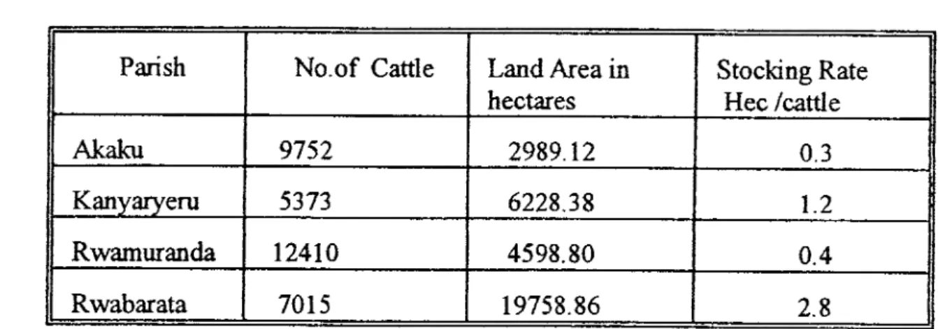
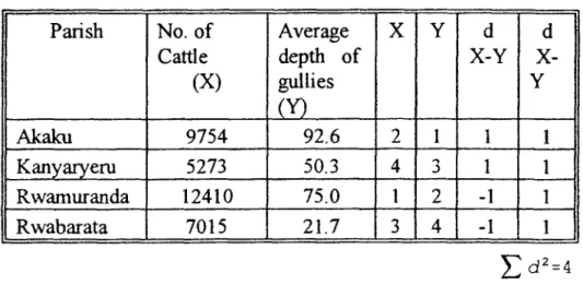
4.3 Cattle stocking rates ...62
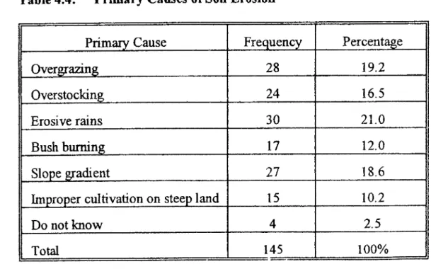
4.4 Primary causes of Soil Erosion ...64
4.5
Approximate number of cattle, gullies, percentage of bare ground
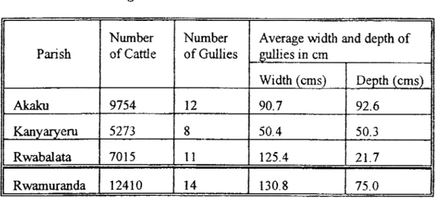
and average depth and width of gullies ...66
4.6 Effects of burning on the environment.... . ... 74
4.7 Level of Education and Conservation index ...90
4.8 Geographical distribution of the sample in various parishes.
..92
4.9 Effect of distance on attitude towards conservation ... 93
4.10 Soil Erosion control ...96
LIST OF FIGURES
2.1 Rainfall characteristics recorded at Rwonyo Headquarters, Lake
Mburo National Park, 1996 ...14
4.1 Major sources of income. ... ... 53
4.2 Months of the year when Pastoralists graze in the park ...
59xi
LIST OF MAPS
2.1 Location of Nyabushozi county and SangaSub-county in Mbarara district... ... ... 9 2.2 Location of Lake Mburc, National Park in Nyabushozi county, Mbarara district ...10 2.3 Location of study area and Lake Mburo Nalional Park ...11 4.1 Approximate extent of degradation of Lake Mburo National Park
and the study area parishes ...78
LIST OF PLATES
4.1 Severe Overgrazing and Erosion ...79 4.2 Bush burning ...80 4.3 Erosion ...81 4.4 Gulley Erosion. ... ... 82
4.5 Developed Erosion Gullies ...83
xi i
ACKNOWLEDGMENT
This study would not have been possible without the support and assistance provided by several people. I first acknowledge the support and assistance provided by the Government of Uganda for funding my course and partly funding this study, the staff of the Department of Geography, Makerere University for providing me with all the knowledge which has greatly been applied in this study.
Special thanks go to Mr. B. Nakileza who helped me to develop the proposal for this study and later supervised this work I highly benefitted from his contributions and advice. I also commend Mr. G. Magawa and Mr. J.C. Sebunnya, cartographers, who prepared all the maps and illustrations.
I wish to also thank all government official, park management officials, the staff at African Wildlife Foundation (AWF) Kampala office and the people of Sanga sub-county whom I came in contact with during the study, for being vety co-operative and providing me with all the information I needed.
Sincere expression of gratitude goes to the following people for their unending support and encouragement during the course of this study; MIS Namara Agripinah, MIS Keirungi Jackie, Mr. F. Bagoora, the park officials, Mr. Matovu Mutwalib, Mr. Tumwine, and all my brothers and sisters.
xiii
I hope
this
dissertation will greatly contribute to discussions aimed at improving the park conmmnity relationship, sustainable resource use áid development of Sanga sub-county and possibly for all the areas surrounding Lake Mburo National Parkxlv
ABSTRACT
The long term success of the conservation of the protected areas depends heavily on the co-operation of the local people. Their attitudes need to be incorporated into the planning and management of the protected areas especially if the land use conflicts which tend to charactense conservation areas are to be resolved.
This study is an effort to address the landuse conflict between pastoralism and wildlife conservation in Lake Mburo area, its effect on the environment and attitude formation. A survey was mainly carned out in the parishes which border with the park in order to clearly examine the land use conflict. Data was obtained from 105 randomly selected general users of the land from four parishes in Sanga sub-county. Elders, opinion leaders, local council officials (LCs), government and park management officials also provided some information. Data was collected using rural appraisal techniques, questionnaire, interviews, consultations and secondazy data sources.
Survey results indicate that the land tenure uncertainty, low levels of education, overstocking, overgrazing, traditional grazing methods, lack of sound conservation policies and increasing population have resulted in an environmental crisis. All the above were found to have great
xv
implications on the sustainable use of resources and development of Sanga sub-county.
This study makes recommendations covering land use, the environment, the park, water resource, rural development, legal frame work and further research required.
The study concludes by giving goals and strategies for sustainable development of Sanga sub-county.
CHAPTER ONE
1.0 INTRODUCTION
1.1 GENERAL BACKGROUND OF THE PROBLEM
The government of Uganda has gazetted a number of large areas as national parks mainly in an effort to preserve its unique eco-systems and related bio-diversity. However, this has created land use conflicts especially where these areas contain valuable natural resources which for a long time have been utilised by the local communities. This conflict has intensified with increase in population, which coupled with land shortage, has resulted in persistent encroachment on protected areas.
Wildlife conservation often clashes with traditional land uses such as grazing and cultivation. Peasants farmers and pastoralists look at protected areas as the last remaining frontier for cultivation and grazing. Faced with production constraints, pastoralists have little understanding of the value of conservation, particularly when portions of the reserved areas formed part of their traditional grazing area (GAF Consult, 1993). In Uganda, during the 1980ts period of political turbulence, the local communities took this opportunity to encroach on protected areas with a view of fimily establishing themselves there (Kamugisha and Stahl, 1993). In Lake Mburo National Park (LMNP) the landuse conflict became prominent in 1983, when the entire game reserve was declared a National park and the people were evicted from the gazetted area. The local people
40
believed that if the wildlife in the Park valued by the government was destroyed, the authorities would lose interest in the area and leave it to them (Kamugisha and Stahl, 1993). This attitude further complicated the landuse conflict.
Furthermore the conflict is compounded by conservation authorities who seek to protect the park, disregarding the efforts, interest and influence of the local communities. This sharpens local resentment of wildlife and encourages local people to draw the conclusion that government places a higher value to animals and plants than on their well being. The conflict becomes much more serious when people begin to suffer in favour of wildlife, presumably being preserved for the good of the same people (Kafureka, 1992).
Protectionism which seeks to protect the park or game reserve, from the surrounding society cannot always ensure the sustainable conservation of natural resources. The logical alternative is to transform the local communities into protectors of parks and game reserves. To achieve this objective any development effort should consider the people of the place where it is to be located as beneficiaries and not victims. It should also seek to utilise their wealth of experience accumulated over years
seeking to know what they do, why they do it and in the way they do it, if it is to avoid surprise failures (Kafureka, 1992).
3
This research is therefore an important step in understanding the peoples relationship to the land and natural resource use and their attitudes towards conservation. The focus is on the land use conflict between pastoralism and wildlife conservation with emphasis on its effects on the environment.
1.2 STATEMENT OF THE PROBLEM
This study analyses the conflict between pastoralism and wildlife conservation and its effects on the environment and on attitude formation. The Bahima pastoralists residing in and around the park regard the savanna grasslands of Lake Mburo area as their traditional grazing lands. They therefore argue that the national park is depriving them of their right to graze in the Park area. The park authorities on the other hand feel they are duty bound to protect and conserve wildlife, This has resulted into a land use conflict especially over pasture and water.
Pastoralism forms the major part of the landuse conflict. The restriction of the pastoralists from grazing in the park, resulted in limited grazing land in the areas surrounding the park. This has contributed to overstocking and overgrazing. It has also led to the encroachment on the park in search of water and pasture especially in the dry season. This forms the basis for the landuse conflict, which this research mainly investigates with particular reference to sanga subcounty.
4
Research carried out so far on land use conflict in Lake Mburo area has focused mainly on other areas other than Sanga Sub-county and moreover with little regard to its impact on the ecosystem. This study therefore focuses on how pastoralism has led to environmental degradation in the study area and what steps have been taken to resolve the resource use conflict especially through the efforts of the Lake Mburo Community Conservation Project (LMCCP). The study also analyses the measures which can be taken to ensure that pastoralists benefit from wildlife conservation without contravening conservation laws and enable them have positive attitude towards conservation of wildlife.
1.3 SCOPE AND PURPOSE OF THE STUDY
The study mainly covers the areas bordering the northern part of Lake Mburo National Park in the parishes of Akaku, Kanyaryeru, Rwamuranda and Rwabarata (Map 2.3) These parishes are mainly occupied by pastoralists who utilise resources in and outside the national park The principle objective of this study is to analyse the landuse conflict between pastoralism and wildlife conservation, its effects on the environment and how the conflict can be resolved.
5
of cattle and the density of soil erosion gullies, between the level of education, the distance from the boundary of the park and their influence on peoples attitude towards wildlife conservation.
1.4 SPECIFIC OBJECFI YES
Find out the nature of the land use conflict between pastoralists and wildlife conservation.
Analyse the effect of pastoralism on the environment in the park and the surrounding areas.
Examine the effects of the landuse conflict on the community and their attitudes towards conservation.
Identify the strength and weakness of the efforts to resolve the landuse conflict from 1990-1997 and formulate appropriate recommendations.
1.5 HYPOTHESES
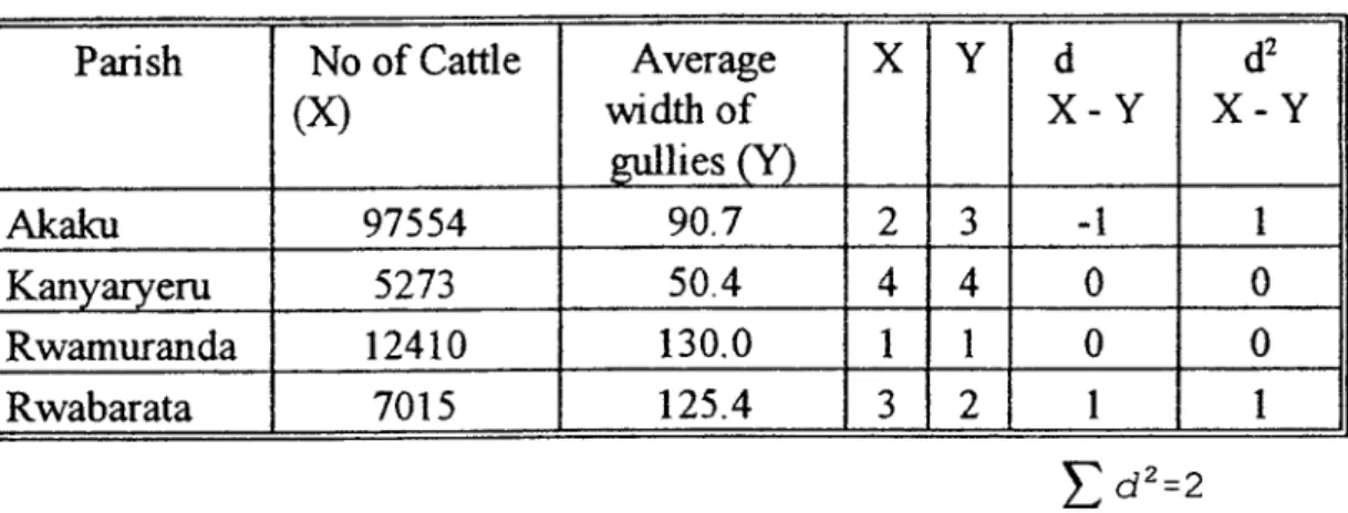
No relationship exists between, the number of cattle and the density of erosion gullies.
The level of education influences the peoples attitude towards wildlife conservation and soil conservation.
The increase in distance from the park boundary has no
effect on the positive attitude of the local people towards wildlife conservation.
1.5 SIGNIFICANCE OF THE STUDY
Most of the research carried out in the lake Mburo area and the surroundings has mainly revolved around ranching and wildlife conservation. Little research has been carried out on the communities around the park with regard to their landuse practices and patterns.
There has been no specific research addressing the lariduse conflict between pastoralism and wildlife conservation and its effect on the environment in Sanga Sub-county. More so, no specific evaluation has been done in the area about the success of the conservation projects, which were set up to resolve the resource use conflict between the park authorities and the local community.
Therefore there is need for this research because the eco-system is at stake; especially with increasing human and livestock population in the areas bordering the national park Wildlife has to be protected but also the interests of the landless pastoralists in and around the park need to be considered since the park covers a large portion of their traditional grazing land. This called for a detailed research geared towards formulating appropriate recommendations on how to resolve the landuse use conflict,
7
conserve the eco-system and develop community support for wildlife
conservation.
The data collected will help improve management systems for
resource use and allocation, assist in the formulation of appropriate park
and government policies concerning resource utilisation and management
in protected areas.
[:1
CHAPTER TWO
2.0 AREA OF STUDY AND REVIEW OF RELATED LITERATURE
2.1 BIOPHYSICAL BACKGROUND 2.1.1 Geographical Location
The study area, Sanga sub-county, is situated on the northern boundaiy of Lake Mburo National Park in south central Uganda, along the Mbarara-Masaka high way, 40 kms east of Mbarara town in Nyabushozi county, Mbarara district. Sanga Sub-county covers an area of 878.90 km2 and it lies between latitudes 0038' South and 0041' South, longitudes 300 55' East and 310 57' East (see map 2.1 and 2.2).
2.1.2 Geology and Soils
The geology of the area is part of the Karagwe - Ankolean rock system; consisting of wholly granitized undifferentiated gneisses and elements of pre-Cambrian partly granites rocks (Uganda Atlas, 1967).
The soils have been derived from weathered materials of pre-Cambrian rocks derived from pre-Karagwe Ankolean age basement complex. They are mainly ferrallitic soils of sandy type and occasionally sandy loam soils can be found in valleys. The steep slopes are mainly dominated by laterite soils.
Kompolo P4okatro \
J
MASA K A Ntusi\ :J
°00. ...r
I
I ; I N osakaMap 2.1 LOCATION OF NYABUSHOZI COUNTY AND
SANGA SUB-COUNTY IN MBARARA DISTRICT
Fort Porfa! / oop KABARCLE ( I BA : KAZO Mahoro\ DA:
•'v
' lbnd '- B U S H E N Bwizbwera. /\
8hQnyi !K ASH ARI
•
1....•
. Kononi WtxkAPtPA L. Kachéen 1000'S b t OS -4
... --t- .. - - - - -' - ++.+flTerflonaL nounoory - .Uistrct boundary Coun+y boundary&WC' Sariga sub—county rzz Nyabüshozi county
I1
District boundoy 0 Trading Centre Pood -f-*++-'4+ 0 20 0kmMap2.2 LOCATION OF LAKE MBURO NATIONAL PARK IN NYAt31Jt1UL1 PUNTY. t MASAKA —0coo'— E OUA T 0 ___ -..---•
I
\BWETAMC . \ AA K A Z a co U N I y MACUNCU/r
I
(; A•_' Ko zo It\ /(
...7Tt
:I
~
16A N DA?' t. s P ' TAN C C COUNTY 8YAN RUGON GI AM1RA . 1 \ / KASHONGI 4KAl — / -.*... .. / KAYONZA . M / ... ... / ... NVA4ASHARARA 8izibwero i.:. .. ... A . S ... AG KAS H A RI CO UNTY N NMB(_O
S cqo 03 O
. P U K U K URL -. Bushenyi HPAPMEA L.Kacr.Kikagati ISINGIRO CO NTY
L e g :rd
ro
E
Notional Park boundary
District Headqucriers \ E U K A N C 3 u
0 Trodino Centres
—. Tormcc road
a: a. -J z 0 I.- z 0 a: w -J 0 z 4 w a: 4 C I- U. 0 z 0 I- 4 0 -J cn 0. a a a —4 a 0 a C L1 a 'a C a C a a a-0 4.. a a. a C a Z4 I I
I
I'•._iL/
\
I • SiI
S I... Id .000 CL CD Cc 4"I
/11
111!, ! ._'
1
13 .0001Ii
C a a I.., 0 a '4 a IJI '4,
1
r
12
Hydromorphic soils exist mainly in areas covered with swamps. The development and characteristics of these soils are influenced by permanent or seasonal water logging. Peat and organic hydromorphic soils including clay are rather scattered in seasonally water logged areas.
These soils have been leached and eroded for many years hence soil nutrient levels are low. Fertility depends greatly on reserves of plant nutrients in humic organic top soil, which also depends on continued renewal by vegetation. Hence the soils need to be protected from erosion (Karnugisha and Stahl, 1993 and Uganda Atlas, 1967).
2.1.3 Topography
The northern side of the national park and the Sanga sub-county areas lie between 1219 and 1828 metres above sea level (Monday, 1991). The relief consists of undulating to dissected plateaus. The southern part of the sub-county is dominated by hilly and upland areas. The uplands are interrupted by a series of areas which have low lying terrains and usually these consist of a granite floor and a resistant phylite and quartzite. The rest of the study area consists of undulating low rolling hills with fairly wide valley bottoms (Kamugisha and Stahl, 1993).
2.1.4 Climate
The climate of Lake Mburo National Park and the surroundings can be described as hot and dry for most parts of the year. The area is located
in the Ankole - Masaka dry corridor. Climatic data was obtained from Lake Mburo National Park weather station records and the Meteorological Department in Kampala The mean monthly rainfall and mean maximum and minimum temperatures for the period 1960-1964 and 1996 for Mbarara are given (Appendix VI). The 30 year mean annual rainfall is 945.5 mm. The rainfall is bimodal in nature, with two rainfall peaks occurring from April to May and from September to November. Pronounced dry season occurs in June/July to August and December to February as indicated in Appendix VT and as recorded at the weather station in the park (Fig2. 1). According to the residents of the area the dry seasons can be quite severe, sometimes leading to drought. Rainfall tends to be erratic lasting for a short period of 30-60 minutes and it is unreliable (Kasoma,
1993) hence affecting the behavior of pastoralists and wildlife.
Temperatures are generally high throughout the whole year, ranging from 20°C to 28°C in the wet season and 28°C to 30°C in the dry season. However, with difference in altitude, there are bound to be variations in temperature at different altitudes within the study area.
if
Fig. 21 Mean Annual Clima+ic Charoc+eristics Recorded
at Rwonyo Headquarters, Lake Mbu ía NtiOnQi Ptii k 1996. 35 30 25 U 201— 15 L 4.1 a 10 G' a E 0 16( 14 E E 12 = lO a C 2
Mean Maximum Temperature Mean Minimum Temperature
i -
00/ 0
•0
0-I•iI___
//v'Ell
j 0//z
- J F M A M J J A S 0 N D MonthsSource Adap fed from Park climatic records of January to December, 1996.
15
2.1.5 Drainage
The Lake Mburo National Park area and the suiToundings lie in the Lake Victoria catchment area. Most of the permanent water sources are found in the southern part of the park, which is associated with a chain of Lakes like Mburo, Kazuma, Kigambira, Mutukwa and Bwara. (Busuiwa,
1993)
Associated with these lakes are extensive swamps which exist in valley bottoms, though they are becoming less frequent because of changing climate and human influence. Rwizi is the major river in this area and it flows into Lake Mburo. Seasonal streams do occur during the wet seasons especially after heavy down pours but they disappear during the dry season due to high evapo-transpiration rates. Most of the water sources tend to dry up especially in the northern areas of the park, where the study area is also located. This leaves the southern parts of the park, the only area with permanent water sources.
2.1.6 Vegetation
The dominant vegetation type in this region is savanna grassland which forms a continuous community of grass cover with scattered trees; the main tree species being Acacia hockii
16
However, this vegetation has been significantly modified as a result of grazing, cultivation, burning, settlement, construction of cattle kraals and cutting trees
for fire wood. Acacia hockii (orugando) is invading many areas such as the well drained hill sides and low lying bill tops which were formerly much more open and provided good grazing areas for cattle and wildlife.
Cvmbopogon nardw (omutete) which is unpalatable both to wildlife and livestock is abundant and is invading rapidly from the north. The invasion is attributed to overgrazing and frequent burning.
Generally the vegetation in Nyabushozi county can be regarded as
a fire sub-climax. This emphasizes mans predominant role in influencing
the formation of vegetation cover. Frequent burning, cultivation, cutting trees for fire wood and for charcoal and heavy grazing, have been found to reduce plant species diversity which eventually leads to bare ground and soil erosion.
Areas currently under cultivation support many introduced plant species; several exotic plant species have been introduced like sisal (A gave sisalina) eucalyptus and mango trees.
2.1.7 Animals
Lake Mburo National Park and the surroundings have a rich fauna! diversity. However, it has been reduced over the past years as a result of
17
increased human activity like hunting, Tsetse fly control and habitat destruction through cultivation, grazing and settlement (Appendix V)
According to the 1990 park records a total of 68 species were recorded in the park. To note is that Lake Mburo National Park supports Uganda's only population of Impala (Aepyceros melampus. In 1990 count, they numbered up to 10,000 and their numbers are increasing (Appendix V). The most common animals are zebra, warthog, oribi, bushduiker and elancL These species have also been increasing in numbers due to improved protection.
However, there are species which have been declining in numbers, for instance, topi, reedbuck, velvet monkey, baboon and buffalo. Some species which were known to exist in the park, but are now locally extinct include lions, elephant, giant forest hog, black rhinocerous and wild dog. Few numbers of predators like leopards, hyenas and jackals still live in the park (Appendix
M.
The predators are threatened with extinction due to poisoning from the local community especially the pastoralists because they prey on their livestock. The lakes in the park support, crocodiles and some hippos. The surrounding papyrus swamps also support various animals like the sitatunga (information from Park records).Areas surrounding the park, including Sanga sub-county are mainly dominated by domestic animals like cattle, goats and sheep. Some wild animals like impala also graze from outside the park. It is also common to
18
find livestock grazing inside the park, sometimes side by side with the wild
itri ri
2.2 SOCIO -ECONOMIC BACKGROUND 2.2.1 Land use and socio-economic status
The communities around Lake Mburo National Park are made up of a high proportion of households of recent or relatively recent arrivals. Approximately 66% of the communities are immigrants (Marguardt, et.al 1994) From the highly populated parts of Isingiro, Kashari, Rwampara in Mbarara district, from Rukun91 and the war torn Luwero triangle. Those who had been settled in the area before 1983 were given land in the Kanyaryeru resettlement scheme. The recent immigrants are not only landless and subsistence farmers, but also economically marginalised. Social structures are therefore weak hence making community mobilisation activities and assistance in the development of permanent community institutions difficult.
The majority of the community in the study area are pastoralists, although pastoralism appears to be declining. Most households are shifting away from strict dependence on cattle keeping towards a more sedentary form of mixed farming; they rear cattle and also grow some crops. However, in the study area there are also arable farmers who only depend on cultivation for survival. The pastoralists, often enter the park to graze
19
and water their animals, especially in the dry season. This often brings them into conflict with the park authorities.
Land ownership is strongly related to the socio -economic activity. The pastoralists who do not have land live unsettled life than the cultivators who have land.
However, the pastoralists in the Kanyaryeru Resettlement Scheme (KRS) live a more settled life because they were allocated about 40 acres of land per household. Most of them have even started growing crops, along side rearing cattle.
The pastoralists outside the resettlement scheme, for instance, in Rwabarata parish face the problem of landlessness. They were evicted from the national park and they were not considered by the government for resettlement. With this marginalisation, most of them have ended up as squatters on the ranches. Those who have not shifted to the ranches live near the park from where they make daily incursions in the park to graze and water their animals. They are therefore in constant conflict with the park authorities.
In the study area, there is lack of basic infrastructure such as schools, health centres, roads and permanent houses. This is because government which should have provided these facilities, has not yet done so. The people on the other hand, not sure of their legal tenure positions have been discouraged from investing in the construction of infrastructure
20
and even from carrying out any form of land conservation practices like tree planting However,community participation in providing infrastructure is increasing, for instance some primary schools have been built by the community, with assistance from the Lake Mburo community conservation project (LMCCP).
2.2.2 Human population
The area is mainly occupied by Bahima who are traditionally cattle keepers. Most of them were resettled in this area in 1986 from the war torn area of Luwero triangle. Other ethnic groups are mainly cultivators; they include Bakiga, ethnic Banyankole from Mbarara and Mpororo in Rukungiri and some Baganda
The population figures used in this study are drawn from the last four national population censuses - 1959, 1969, 1980 and 1991. Table 2.1 below shows the population figures for Nyabushozi county, where the study area lies.
Table 2.1: Human Population of Nyabushozi County
Year(s) Population
1959 12,665
1969 37,224
1980 77,838
1991 76,200
Source: Statistics Department, Ministry of Finince and Economic Planning, Entebbe.
21
The table shows steady increase in population between 1959
and 1980, with a slight decline in 1991. The study however could not ascertain the cause of this trend. Marquardtet. al (1994) also indicate that there is no apparent explanation for this decline.
The steadily increasing population implies a steady growth in the need for natural resources in the area Given the predominantly subsistence production of the communities in the study area and the low levels of household income, it is evident that local community demands on the areas' natural resources including water, soil, pasture and trees will constitute a major and sustained threat to the conservation of Lake Mburo National Park (Muhwezi, 1993).
The population distribution and density of Sanga sub-county for the different parishes, is revealed in table 2.2.
Table 2.2: Population distribution and density of Sanga sub-county parishes
Parish Population Land
Area (2) Density Persons per sq.km . Rwabarata * 2,899 197.6 15 Kanyaryeru Res.Scheme
*
3,541 138.3 26 Nombe 4,826 276.1 17-
Embaare 1,833 89.6 20 Kayonza 2,010 134.1 15Source: Statistics Department, Ministry of Finance and Ecoiomic Planning, Entebbe, 1992.
22
As revealed by the table above, the population density in the study area is relatively low. However,
this
should not be interpreted to mean availability of enough land and other resources. This is mainly because of the fact that these areas are mostly occupied by pastoralists who own large herds of cattle ranging from 50-600 herds of cattle per household. Thus though the area is sparsely populated in terms of people, it is actually overstocked with catt!e, resulting in environmental degradation, as discussed in Section 4.4.1.2.3 REVIEW OF LITERATURE
Wildlife conservation has increasingly received attention in Africa and it is increasingly becoming not only a biological challenge but also a social one. Various countries have tried to protect their bio-diversity by setting up protection areas which restrict human activity. This has resulted into conflict between the authorities and the local communities who want to utilise some of the resources in the protected areas like water, pasture, fire wood, game meat and gathering of food especially from forests. This conflict has intensified as the human and livestock numbers increase.
Several studies have shown different aspects of land use conflict in conservation areas. The following literature review is an attempt to further
23
on pastoralism-wildlife conservation conflict. It will be reviewed under the sub-headings depicting the aspects of wildlife conservation and community participation, conflict between wildlife and livestock over resource use.
2.3.1 Wildlife Conservation and Community Participation
In analysing conservation and management of African wildlife, Riney (1967) observed that wildlife conservation and development are new sciences of which some of the general principles are known and yet these lead only to general solutions. He therefore argues that what is needed are specific answers to specific problems, whose urgency lies in avoiding the disappearance or extinction of the animal(s) concerned and the destruction of valuable resources.
He further observes that specific problems concern the most basic relations between habitats, animals and man. Animals and their habitat exist in a relatively stable, fluctuating equilibrium and it is unlikely that primitive hunting had much influence. But man using advanced technology of an industrial society, has had no time to fit into the ecosystem, except as a destructive force.
Curty (1981) argues that wildlife management is a complicated activity because of its impact on a wide variety of human activities. He
ti
24
conserving and maintaining animals population in relation to the
environment. It requires a long term ecological based policy which takes
into account land use practices and management. He stresses that
management polices must also always plan ahead taking into account
population pressure on the habitats and wild animals. He finally comments
that important lessons must be learnt from numerous human mistakes and
misuse of land in past centuries in order to reduce, as much as possible,
man's detrimental impact on wildlife and the environment.
Analysing conservation and community participation Drijver
(1994) noted that the relationship between protected areas and local
communities is a key factor in the long term conservation of nature and
resources in and around these areas. He observed that in remote areas of
developing countries it is difficult to maintain effective control without the
support of local communities. He however comments that in many cases
this relationship is more of conflict than support. Conflict typically arises
when local communities perceive the protected area as a burden on their
land use and self reliance, while on the other hand conservationists
perceive the growing numbers and aspirations of local people as a major
threat to the sustainability of the protected area
Related to the above, Anderson and Grove (1987) observes that a
number of conservation and development projects around the world have
25
observe that in order for this to be possible, the projects should aim at the
participation of local communities in the protection and management of
conservation areas as well as in the potential sustainable benefits from
conservation.
Nevvmark (1993) and Infield (1986) point out that historically law
enforcement has been the primary means used by protected area managers
to resolve conflicts with local people, but further argues that the techniques
have proved to be inadequate and often inappropriate in Africa
The local communities surrounding protected areas have generally I
been left out of conservation planning They have been alienated by
conservationists denying them access to resources which have been
traditionally harvested for food shelter and medicine (Infield, 1986).
Hough (1988) reviewed several obstacles to cooperation between
the parks and surrounding human communities in developing countries
today; these include:
(i) institutional environment of national parks.
ii) lack of trust between national park authorities and local people
difficulties in communication between park management and
surrounding commimi ties
the number of actors involved
(
W.
(vi) difficulty of enforcement of protected area - local agreements. Newmark (1993) points out that strategies to involve local people in the planning process, provides them tangible benefits and empowers them to manage their own natural resources. McNeely (1989) observes that while tourism is an important function of natural parks, it is a weak justification for people ling around the park if they are not benefiting in
any way other than preservation of a resource.
Olivier (1992) basing on findings in Murchison falls National Park argues that one of the basic platforms for the effectiveness of a park's management plan, is the recognition and encouragement of real appreciation of the park at both local and national level. He further notes that in the final analysis Murchison Falls National Park will not survive intact unless careful selected target groups are successfully inculcated with a genuine understanding of the parks value to the nation.
Furthermore, Parkipuny (1991) with reference to Serengeti national Park, observes that there is a growing awareness of the disastrous consequences of a reckless approach to development and the limitation of conventional wildlife preservation. He notes that, it is increasingly realised that the solution to the problem of conservation is not to strengthen the power of the authorities against local communities. On the contrary the solution lies in planned integrated management geared to
27
harmonise the conservation of biological resources with the need to overcome poverty and backwardness among the local inhabitants. He further comments that such an approach will not only help to restore vital community support for the existing areas, but will help to mobilise support for the reaction of new integrated management areas, along the lines of biosphere reserves.
In Lake Mburo National Park, the need for community participation was realised in 1989 and the Lake Mburo Community Conservation Project (LMCCP) was therefore set up to create more positive attitudes towards the park amongst the local communities and involve them in the conservation of protected areas.
Marquardt, et.al (1994) reveals that LMCCP was set up in response to what was perceived as a crisis in the conservation status of the park They also note the need to work with local communities to alter the apparently negative attitudes held by local people towards the park.
Infield (1992) observes that Lake Mburo National Park is a classic example of what can go wrong when the authorities think only about protecting wildlife and ignore the needs and feelings of the local people. Several hundred people were driven from their homes to establish Lake Mburo National Park. The people were not consulted about the creation of the park or compensated for the loss of their homes and land. Nor was
I
the intention of the government was. He finally observes that the relationship between the park authonties and the people remains one of conflict and suspicion and there are grave fears that the entire area could still be lost to conservation. Tindigarukayo and Turyatunga (1993) point out that in order to harmonise the wildlife conservation with the communities around the park, the government and the park management in particular needs to adopt an approach that seeks to popularise conservation as a productive alternative land use method. This can best be achieved through community education, mobilisation and involvement of the values attached to wildlife and its conservation. The local mans position of tangible benefits should be clearly defined.
2.3.2 Resource Use Confflct between Wildlife and Livestock
Riney (1967) comments that the conflict between wildlife and cattle includes some of the most explosive land use situations in Africa today. Wildlife competes with cattle for food and they bring diseases into valuable domestic herds. In order to keep wild animals away from domestic animals programmes for shooting out wildlife or fencing off huge areas have taken place in many parts of Africa. Fences in particular are very expensive to erect, they decimate animal populations whose migration routes they cross and are fairly quickly damaged. He cites an example of Botswina, where
29
£60,000 in fencing is said to be destroyed annually by game and large numbers of wild animals have been killed by fences.
In Lake Mburo National Park, Monday (1991) mentions
that
the greatest threat to animal diversity in the park is the existence of very high numbers of cattle within the park. He observes that although cattle and wildlife can co-exist up to a certain point, if cattle densities rise above a certain threshold, wildlife is negatively affected. He also notes that over significant parts of the park, especially in the western hills, large mammal populations appear to be much reduced probably due to the presence of high cattle densities and high levels of human activity including cultivation. He also observed that some of the parks species like roan antelope are more sensitive to disturbance than others and these are the populations that seem to be currently in decline.Furthermore he notes that for the majority of the pastoralists who are living a largely traditional life, subsisting on milk and occasionally selling their cattle to meet specific cash requirements, the park is perceived as a considerable problem. In almost all cases the negative attitudes arise from real conflicts between the demands of the cattle and the demands of the park. The pastoralists are denied access to the grazing resource contained within the park. Lack of access to water is probably the single most imoortant cause of conflict and resentment against the park
30
authorities. The park contains much of the areas where there is permanent
water and pastoralists would like unrestricted access to this resource especially during the dry season. The silting up of many valley dams around the park has aggravated this problem and it is a fact that
these sources are not adequate to supply the demand for water throughout the year
L
On the effect of pastoralists to the park, Monday still notes that the concentration of pastoralists and their herds in the areas has resulted in extreme pressure on the grazing land which in turn results in more pressure
on the park and thus increased conflicts I -
Muhwezi (1994) comments that grazing as a method of rangeland management in Lake Mburo National Park is considered unsuitable in the short term because current park management priorities include eliminating livestock from the park. He observes that employing grazing as a management tool might cause confusion amongst local pastoralists and lead to increased incursions of livestock.
In the report by OAF Consult (1993), According to the GAF Consult report (1993), it is stated that wild game depends on rangel and as much as livestock. The two types of animals co-exist freely even in a pastoral situation without any party being the loser. It is only when the balance in the land use equation is tipped in favour of man that the wild game is
31 branded the culprit.
The report further notes that, the soils are under serious threat of sheet and gully erosion especially along cattle tracks, hill slopes and around water sources. The report states that in reality the national park is still a contested area and as a result of this the park and its environs are experiencing unprecedented high rates of range deterioration and environmental instability due to the pressure from overgrazing and the accompanying soil erosion. More so, soil degradation has been aggravated by burning the already overgrazed areas. Burning results in soils losing nutrients through volatilization (process by which soils lose nutrients by heat and evaporation), fire also leads to biological degradation; organic matter and living organisms die off, hence the rate of decomposition and soil fertility reduces. At stake,therefore is the very unique and rich biodiversity in the area, the immense tourism potential and the survival of the communities in and around the park
However, Tindigarukayo and Turyatunga (1993) argue that the nomadic pastoral people in the Mburo area have a traditional landuse right to as much level as do the wildlife with which they have co-existed since time immemorial. On a similar note, Heady and Heady (1982) argue that domestic livestock and wildlife animals have co-existed on rangelands in Africa and the Arabian peninsular over many years. They note that these
32
ranges have survived mixed grazing and it is now becoming recognised that this practice does not damage the land under careful controlled management. They further add that in order to avoid over use, any common use of rangeland must be carefully evaluated and the numbers of all species closely controlled. With increased research they argue, it is possible that other wild animals could be domesticated and game ranching made possible and profitable. Wild species can be tamed and managed the same way as domestic livestock, as exemplified by a successful pilot scheme which has been carried out in Zimbabwe with the eland (Taurotragns oryx). In Kenya, Laikipia district, ranches have successfully rared wildlife like ostriches, guinea, fowls, crocodiles and frogs whose meat and skins are sold (Elliot and Muthom, 1997). However, it should be noted that the choice of particular species is also affected by family or community tradition.
Kamugisha and Stahl (1993) observed that the cattle keepers currently perceive a need for the water resources of Lake Mburo for survival of their livestock. As long as this continues to be the case, the surrounding park is bound to be invaded. The pastoralists argue that the area was formally their traditional grazing land hence they have a right to graze in the area (Kalekyezi, 1982). This creates a source of constant conflict between the park and the people.
33
Kasoma and Karnugisha (1993) note that in Lake Mburo area overgrazing has resulted in reduced productivity and land degradation. The extensive soil erosion associated with overgrazing has contributed to the silting up of most valley tanks and dams which had been constructed in the area All this has created a scenario in which the rangeland outside the park has declined in productivity and water for livestock has become scarce, particularly in dry seasons. This has made Lake Mburo National Park contrast sharply with the surrounding land and extremely attractive to pastoralists for both pasture and water.
On the issue of wildlife-cattle co-existence, they note that an appropriate mix of cattle and variety of other large herbivores could ensure an optimum utilisation of the primary productivity. Locally it would be necessary to identify those species that are compatible with the type of land use around the park, study their life histories and develop strategies for ensuring the survival of their habitats as well as a mechanism of managing and utili sing them sustainably.
Conservation and development interests have appeared incompatible if not in direct conflict (Schonewald-Cox, 1991; Wells, et.al, 1990;
Hough, 1988; Weber 1989). This problem has been especially acute over years, as developers view natural resources (like forests, wetlands) in terms of their potential economic value, while conservationists attach a whole set
34
of different values to natural resources in their attempts to preserve resources. As a result Weber (1989) states that the two activities, use or protection, have often been perceived as mutually exclusive.
However, more recent literature indicates potential compatibility between conservation and development, Repetto and Gillis (1988), Wells, et.al (1990) observe that biodiversity will be impoverished without shaping land use in a form that preserves it, and that economic development will be hindered and eventually reversed if it omits the kind of environmental policy which seeks to conserve the biodiversity. Conservation is inseparably linked to future of economic development by a form of
mutualistic symbiosis, (Wilson, 1989).
Weber (1981) described two central tenets comprising this emergent paradigm of mutual complementanty. He first acknowledged that before local people can be expected to support conservation activities, they must first attain a certain level of development (that is satisfy basic socio-economic needs). The second stated that without a reliable base of natural resource on which the local people are dependent, development or standard of living improvements will not occur.
However, while conservation and development have begun
to be perceived as compatible, the implementation of successful
/
35
these two efforts virtually impossible. Meshing conservation and development has proved especially difficult when trying to secure widely distiibuted benefits for people living in or near areas, who may have made a livelihood from park resources in the past (Healy, Pers. Comm.)
With this background, it is noted that wildlife conservation and it's appreciation by the local community, is faced by various problems which make the whole process a complex one. This reveals the need for more landuse studies and landuse planning for specific rural areas. It is out of this need that the researcher examines the landuse conflict between pastoralism and wildlife conservation in Sanga Sub-county. The study analyses the relationship between pastoralism, the environment and wildlife conservation in a fragile range land eco-system in order to reduce environmental degradation and at the same time achieve sustainable economic development of the area.
36
CHAPTER THREE
3.0 METHODOLOGY
3.1 INTRODUCFION
This study was done by reviewing and evaluating the existing studies, on the history of land use and land use conflicts, especially between pastoralism and wildlife conservation. A histoncal survey carried Out by the researcher led to an in-depth analysis and understanding of the nature of the conflict; its causes and effect on the environment.
During the study, information and data was collected on various subjects using both primary and secondary sources.
Secondary data sources were used to collect information on: • Trends in land use
• Evolution of land use conflict • Demographic data
The primary data source was used to collect information on the peoples attitude and perception towards conservation.
While both primary and secondary data sources were used to collect information on:
• Environmental issues • Conservation issues • Grazing patterns
37
3.2 RESEARCH DESIGN
Considering the purpose, objectives and hypotheses, the design for this study is multi-faceted in nature. The plan and structure of the investigation was a combination of different research designs.
The multi-faceted design of this study was both quantitative and to some extent qualitative, and both empirical and perceptual. The research mainly presents the data empirically, while some of the data was generated from peoples perceptions. It should, however, be noted that in this report, the findings are presented generally therefore it might be difficult to differentiate where the quantitative or qualitative, empirical or perceptual presentations begin and end.
3.2.1 Survey
The basic design for this study was a survey, in which self reported data was collected from a sample to describe environmental issues, pastoralism as a land use form, its conflict with wildlife conservation and development issues. It involved asking 105 general land users questions which were related to the research problem; the main aim being to
relate the problem to the peoples attitudes and percep€ons.
The survey that was used in this study is a cross sectional survey. This survey collected information from a random sample that has been drawn from a pre-determined population (Opolot, 1993). The information
collected from the sample was therefore from a cross-section of people as indicated in Section 3.3.
3.2.2 Correlational Design
This study examines the relationships between various dependent and independent variables. Correlation statistical research methods (for example, Spearman rank correlation co-efficient method) were used to determine the degree of relationship existing between different variables such as land use, resource use, environmental conservation and peoples attitude and perceptions towards conservation.
3.3 THE SAMPLE AND SAMPLING METHOD
In this study the target population were pastoralists in the northern parishes which border with the national park. A member of this target population had to be a person with a household under his jurisdiction, independent of others.
Due to limited time and resources available, the survey was based on a sample from four (4) parishes (see map 2.3) which were in a 10 kilometre radius from the park boundary. These parishes were chosen for various reasons including, land use patterns, extent of pastoral activity, road accessibility and their marked differences in pastoral population density.
39
In this study the sample or the research subjects consisted of three categories. The
first
category consisted of 120 randomly selected people (with cattle and canying out open grazing). Each parish was stratified into two sample areas, one bordering the park in a distance of 0 -5
kms and the other in a distance of5
- 10 kms from the park A stratified random sampling method was then used to obtain at least 10 respondents from each sample area as shown in table 4.8. Members of this category responded to a questionnaire directly administered by the researcher.The second category consisted of 10 pastoralists of above 50 years of age (elders chosen for their historical views and perspectives) who were not covered in the first category. They were selected from the population by use of non-probability sampling method or non-random method. They mainly responded to interview schedule questions administered by the researcher in a face-to face interview.
The third category consisted of village council officials (LCs), religious leaders, park management personnel like the community conservation warden and members of the park management advisory committees, who did not fall in the two categories above. These were located for consultation purposes.
The stratified random sampling procedure was used to select the sample for the first category of respondents. This method was used because it was considered to be systematic and an acceptable scientific
40
process. The subjects for the second and third categories were located using non-probability sampling methods. This is because these categories of the study population were more or less needed for consultative purposes.
In almost all surveys, some members of the selected sample fail to respond to the research instruments. This may be due to lack of interest in the topic, unwillingness and refusal, absence at home or illness.
Therefore, the researcher had to make a decision about the minimum acceptable sample size before the process of data collection began. For this study the minimum acceptable sample size was fixed at 100 households out of the intended 120.
After the completion of data collection respondent and non respondent members of the sample in each parish were noted as indicated in the table below.
Respondents and non-respondents of the sample
Parish Respondents Non-Respondents
Akaku 30 0
Kanyaryeru 26 4
Rwamuranda 28 2
Rwabarata 21 9
• 41
Therefore out of the targeted 120, 105 households contributed The other 15 were not located mainly because of absence at home and others refused to respond probably because of suspicion that the researcher was 'spying' for the park authorities.
3.4 RESEARCH INSTRUMENTS
The following research instruments were used in this study: 1. Rapid Rural Appraisal (RRA)
Rapid Rural Appraisal was conducted in the communities living around the northern border of the park. This was used to collect information from the local community rather than relying exclusively on pre-established questionnaires.
The RRA technique included among others sketch maps, diagrams, ranking activities and semi-structured interviews with both the community groups and key informants.
Rapid Rural Appraisal was used to obtain information on the community's land use practices, awareness of all conservation and perceptions towards the park relationship with the community. RRA was also important to enable familiarisation with the study area, the local population and their perception about developmental issues and priorities. This method offered a valuable tool in developing a good working relationship that is very important in such an area of conflict over natural
42
resources, where the local community is veiy sensitive and suspicious of any stranger carrying out research.
In order to ensure good quality, the data obtained from the various group interviews conducted, was checked and corroborated with information from key informants.
A comprehensive land use survey was used in order to assess real biophysical situation in the study area A wide range of tools and techniques were used to collect information. They included self taken low oblique ground photographs, on ground field survey, mapping and general recording of the existing land use positions.
Questionnaire
A questionnaire (Appendix I) was given to the respondents by the researcher to tick the answers chosen or fill in the space provided. Those who could do not read or write were assisted by the researcher. The questionnaire was designed to collect four types of data.
• biographical data including social and geographical background of the household, education level, socio -economic data like main economic activity.
• Pastoral activities, including, grazing areas, objectives of rearing cattle and land acquisition.
43
S Respondents knovviedge of environmental degradation and soil
conservation practices.
• The communities attitude towards conservation, resource use and perception of the purpose and benefits of the park.
The formal questionnaire interview was administered by the researcher to heads of randomly selected households to fill in their responses. This method was an effective way to enlist the cooperation of respondents. It enabled the researcher ask direct, easily understood questions and made follow up easy.
The questionnaire was translated from English into Runyankore (the local language) by a linguist The responses were then translated back into English ensuring that they still carried the same meaning.
A check list of statements (Appendix II) was also used to determine the respondents perception of the park and conservation in general. The respondents were requested to state whether they agreed or disagreed With or did not know the statement. Those who remained neutral were indicated by the No response'.
4. Interview Schedule (appendix ifi) was a set of questions used to enlist oral responses concerning the inner dynamics of landuse, environment and conservation issues. The questions verbaly were asked on a face to face basis and the responses were recorded by the researcher. This was especially administered to the elders, local council officials,
44
opinion leaders and park authorities.
5. Consultations and check list of questions were carried out among people knowledgeable about the park, like elders, members of the Park Management and Advisoty Committee (PMAC), Community Conservation Project (CCP) and with academicians especially those who have done research in the Lake Mburo National
Park
3.5
RESEARCH PROCEDURE
This section briefly discusses the what, when, where and how this study came to what it is.
The idea of the researcher was to have a study that could be conducted in a marginal fragile environment. It is from this that the research problem was identified, conflicting land use in and around Lake Mburo National Park Sanga Sub-county, Mbarara district.
After identifying the research problem, review of related literature was carried out on the general land use conflict in Nyabushozi county in particular. A research proposal was then compiled and presented for approval. An introductoiy letter was secured from the Head of Geography Department Makerere University (Appendix VII). It explained the purpose of the research and requesting for every assistance needed for the success of the research study.
)
T
Field research work started in December 1996. The first task in thefield was to prepare the sample frame and carry out a general landuse survey. The second task was carrying out a sample survey using a questionnaire which was administered to 105 people. Consultations were also carried out with elders and other people knowledgeable about the area of study.
Compilation of the data collected from the field and its analysis began in Februaxy 1997. During this time, the expansion of the literature related to the research problem was also done. The process of data compilation and analysis was done manually. This was dictated by the financial position of the researcher. As a result, compilation and analysis of the data took a lot of time. The writing of the report began in April
CHAPTER FOUR
4.0 RESEARCH FINDINGS
The research findings are mainly organised in six sections; land issues, land use, resource use, effect of pastoralism on the environment, attitudes and perceptions of the people towards community conservation. This was in line with the objectives and hypotheses of the study.
4.2 LAND ISSUES
The land issues covered in this study includes land crisis, land acquisition and land tenure.
4.1.1 Land Crisis
The land crisis in the Lake Mburo area can be well explained from the general lard crisis in Mbarara district as a whole. In pre-colonial Uganda, most land was held under customary ownership. Population was still low, and there was enough land especially for an activity like pastoralism. The Ankole - Masaka dry corridor (where the study area lies) formed the major traditional grazing ground reserved for the kings of Ankole in 1800s (Kalekyezi, 1982).
However, during the colonial and post colonial period there were changes in land ownership and land use. These changes greatly affected
I
47
the pastoralists During colonial times land ownership began to be
individualised especially since the 1900 Buganda agreement. However,
in Ankole , where Mbarara is located, land alienation was a result of 1901
Ankole Agreement. Part of the land was alienated as mailo land to the
chiefs of Ankole and the rest was termed as crown land.
In the 1960's private land osership was becoming common and the
communal lands were grabbed by the influential and rich people, leaving
the poor who could not afford land, especially the pastoralists with less
land (Kafureka, 1992). More so in 1960 a big area was alienated for
ranching and this pushed mainly pastoralists on to the margins of the
ranches. They were not the kind of people to be considered to run ranches;
therefore the pastoralists resorted to occupying the Lake Mburo area. In
accordance with the Uganda Game Act of 1964, 650 km2 of the Lake Mburo area was declared a game reserve. Some cultivators and cattle
herders living in the area at the time were allowed to remain under agreed
conditions and they were given game department permits.
After the 1975 land reform Decree, because of further grabbing of
whatever remained of the communal lands, many people were further
pushed into these reserves. Due to increased encroachment on Lake Mburo
game reserve and the need to preserve the biodiversity, in 1983 the
government declared the entire game reserve a National park. All the