HAL Id: hal-01544124
https://hal-univ-rennes1.archives-ouvertes.fr/hal-01544124
Submitted on 20 Jun 2018
HAL is a multi-disciplinary open access
archive for the deposit and dissemination of
sci-entific research documents, whether they are
pub-lished or not. The documents may come from
teaching and research institutions in France or
abroad, or from public or private research centers.
L’archive ouverte pluridisciplinaire HAL, est
destinée au dépôt et à la diffusion de documents
scientifiques de niveau recherche, publiés ou non,
émanant des établissements d’enseignement et de
recherche français ou étrangers, des laboratoires
publics ou privés.
Distributed under a Creative Commons Attribution - NonCommercial - NoDerivatives| 4.0
interim results on the city of Alet
Yann Bernard, Jean-Baptiste Barreau, Catherine Bizien-Jaglin, Laurent
Quesnel, Loïc Langouët, Marie-Yvane Daire
To cite this version:
Yann Bernard, Jean-Baptiste Barreau, Catherine Bizien-Jaglin, Laurent Quesnel, Loïc Langouët,
et al..
3D model as a dynamic compilation of knowledge: interim results on the city of Alet.
Virtual Archaeology Review, Spanish Society of Virtual Archaeology, 2017, 8 (16), pp.51-60.
�10.4995/var.2017.5862�. �hal-01544124�
Virtual Archaeology Review, 8(16): 51-60, 2017 http://dx.doi.org/10.4995/var.2017.5862 © UPV, SEAV, 2015 Received: June 1, 2016 Accepted: December 8, 2016
*Corresponding author: Yann Bernard, yann.bernard@univ-rennes1.fr 51
3D MODEL AS A DYNAMIC COMPILATION OF KNOWLEDGE: INTERIM
RESULTS ON THE CITY OF ALET
Yann Bernard
a,c,*, Jean-Baptiste Barreau
a, Catherine Bizien-Jaglin
b,
Laurent Quesnel
a,
Loïc Langouët
b, Marie-Yvane Daire
aa UMR 6566 CReAAH, Université de Rennes 1, Bâtiment 24-25 Campus de Beaulieu, 35042 Rennes Cedex, France.
yann.bernard@univ-rennes1.fr, laurent.quesnel@univ-rennes1.fr, jean-baptiste.barreau@univ-rennes1.fr,
marie-yvane.daire@univ-rennes1.fr
b Centre Régional d'Archéologie d'Alet, BP 60, 35413 Saint-Malo, France. langouet.loic@wanadoo.fr,
catherine.bizien-jaglin@wanadoo.fr
c VIRTUAL-ARCHEO, Université de Rennes 1, Bâtiment 24 Campus de Beaulieu, 35042 Rennes Cedex, France.
contact@virtual-archeo.com
Abstract:
The late Iron Age capital of the Coriosolites, City of Alet, scattered today in a neighbourhood of Saint-Malo (France), has become since 2015 the subject of experimentations in digital archaeology. These have led us to define as objective a relevant three-dimensional (3D) reconstruction integrating different buildings, but also a precise topography, as part of the coastal geomorphology, environmental vegetation and naval activities. First pillar of this reconstruction, 3D laser and magnetic surveys were conducted in order to get some digitised work supports, but also to raise some scientific issues. As part of the main Roman cities of Brittany, the historical study of the City began at least at the end of the 19th century
and archaeological excavations began in the 1970s. So knowledge present in a wide spectrum of archaeological and historical references was then compiled. 3D reconstruction of the City, editable to adapt to new contributions and scientific discoveries, allows a dynamic synthesis of archaeological knowledge accumulated along the years. Because it was done within an archaeology laboratory, it was directly monitored and controlled iteratively by researchers in the field (site, area and period). This work currently allows archaeologists to face limits and constraints regarding this scientific process and better understand the organizational aspects of the City.
Key words: coastal and island archaeology, 3D laser scanning, ground penetrating radar (GPR), 3D reconstruction.
1. Introduction
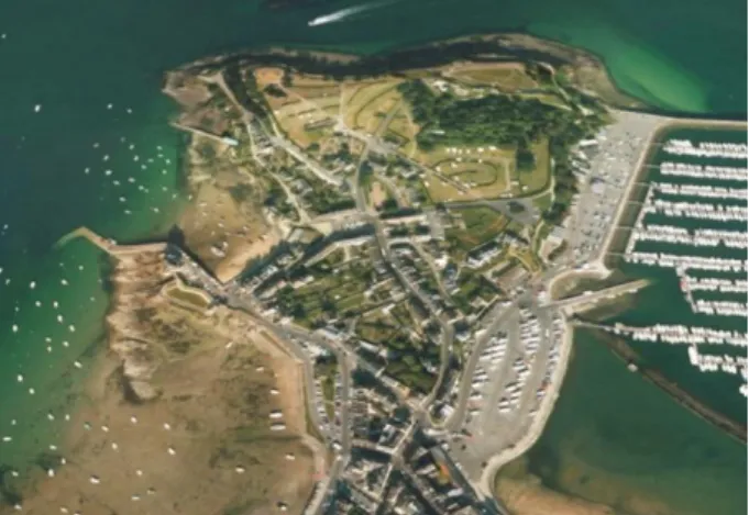
The aim of this paper is to present in greater detail a recent 3D modelling experience (Bernard, 2016), resulting from the exploitation of diverse data in a regressive historical approach. The site under study is the Celtic and Roman famous port of Saint-Malo, located along the French coast of the Channel, birth on the Alet promontory (now part of Saint-Servan), which is identified as the centre of the Coriosolite Gaulish tribe (Fig. 1). As our work lays on an interdisciplinary approach, favoured by a peculiar research context, the
respective benefits of the various sources of data will be first compared.
Second, we will present the results of the compilation of the data in terms of 3D modelling, now widely encouraged (Beacham, 2011) and useful for scientific research (Vergnieux, 2011), to show how it can help to develop a more global approach in terms of site evolution. Then, we will discuss the results and apply a new presentation method of the 3D models, which permit to rank the various parts of the reconstruction, with various degrees of reliability.
2. Data sources and context
2.1. Framework context
In close cooperation with the research team CeRAA (Centre Régional Archéologique d’Alet), the leader of the archaeological researches on the site of Alet, the Common Cultural Connections (CCC’s) European project recently provided an opportunity to develop an interdisciplinary approach on the 3D digitalisation of the site and first reconstruction developments. The aim of the CCC’ project is to enhance understanding of the shared cultural heritage of the three European partner regions through an innovative mobile exhibition; then, the reconstruction of the Alet ancient port was developed as an illustration of the late Prehistoric and Roman saling roads and contacts along the Channel-Atlantic façade of Europe.
2.2. Diversity of the data sources: the benefits of an interdisciplinary approach
The specificity of the Alet ancient city case study is the diversity of complementary sources of data available: underwater and terrestrial archaeology, historic sources (texts, ancient maps, photos and drawings), geophysical surveys and monitoring, environmental studies, etc. Each of them, taken independently, was not sufficient to draw a complete and accurante view of the past of this site. But, by combining the data, it became then possible to propose a historic re-construction of the Roman city, built on precise evidences completed by some hypothetical reconstructions.
2.3. Historical and archaeological references
The history of the City of Alet was first reconstructed thanks to the exploitation of several ancient texts (Tabula Peutingeriana, Notitia Dignitatum, Vita of Saint-Malo, Episcopal lists...). The “Roman d’Aquin”, or “Conqueste de la Bretaigne par Charlemaigne” is a medieval poem from the 12th century, modified in the
15th century, giving precise indication on the ancient
names of the city (Langouët, 1976). Moreover, this text describes precisely several characteristics of the City and its sourrounding area, during the Roman times: architecture of the ramparts, and the towers dominating the harbour, the river Rance landscape, etc.
The sea surrounded every day the Peninsula which was bordered on one side by a small inlet of La Rance river. A keep, called Aiquin or Oreigle tower, was isolated on a rock reached by sea and defended the southern fortified gate. A postern allowed to acces directly to the harbour. In the centre of the town, there was an ancient palace that could be reached by turning left onto the road coming from the city gate. An underground aqueduct allowed the water supply.
This historical sources have been early completed thanks to the ancient excavations (1890, 1907, 1908, 1965-1968) (Dos, 1969) (Fig. 2), and, more recently, by a significant land and underwater excavations programme (Fig. 3 and 4) conducted on site by the CeRAA since 1970 (Langouët, 1973).
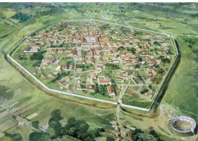
The first objective of our approach is to get an overview of the city. There are many works about the Italian Roman cities reconstitutions (Dylla, 2008; Christen, 2015). These are based on plans and are sometimes procedural with grammar rules (Müller, 2005; Noghani, 2012). Closer to Brittany, a reconstitution of Calleva Atrebatum (southern England) has been proposed as a
drawing (Fig. 5) (Johnston, 2015). However and due to the cultural influence, it is possible that there were architectural and urban differences, no matter how small, for Roman cities based precisely in Brittany. Drawing inspiration from these multiple examples, we keep the possibility of uncertainties in mind.
2.4. Topography
It was not possible to obtain a precise topographic map of the entire city. However, there is in France an infrastructure called "Géoportail" for geodata and services dissemination. The Géoportail website (http://geoportail.gouv.fr) and its applications use the services of this infrastructure to facilitate accessibility of reference geographic information by individuals, public bodies and businesses. This website is widely used by the French archaeological community (Chaumet, 2008)
Figure 2: Map of the remains of the Alet urban boundary walls drawn by Abbé L. Campion in 1908 (Dos, 1969).
Figure 3: The assumed Roman Forum of Alet (Langouët, 1987).
Figure 4: Excavation of a pedestal in the 1960s, in Alet (Dos, 1969).
Figure 5: Silchester Roman City Walls, reconstruction drawing by Ivan Lapper (Johnston, 2015).
3D MODEL AS A DYNAMIC COMPILATION OF KNOWLEDGE: INTERIM RESULTS ON THE CITY OF ALET
Virtual Archaeology Review, 8(16): 51-60, 2017 53
Figure 7: 3D models of Liburna (foreground) and Comacchio type ships (doc. Y. Bernard).
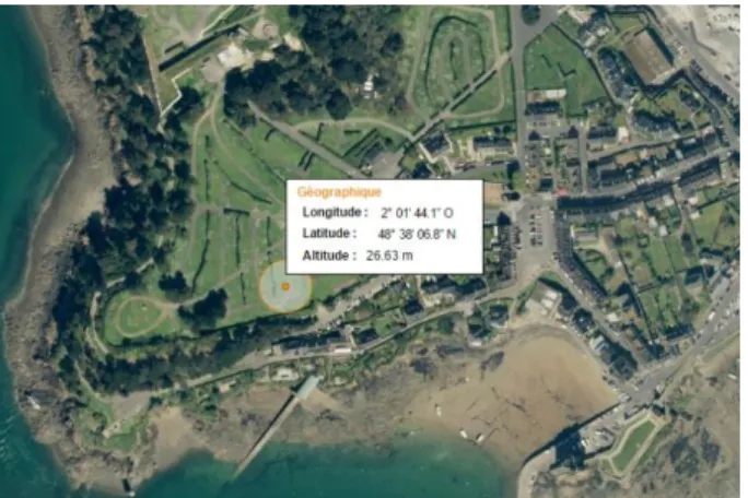
and can provide in particular either the altitude of a position or the elevation profiles (Fig. 6). Although it may seem tedious, the strategy was also to build a digital elevation model as accurate as possible. The terrain was then smoothed in 3ds Max 2015 in order to generate a plausible result.
2.5. Coastal geomorphology
In addition to the archaeological and palaeoenvironmental data on the Alet peninsula, the geomorphology illustrates the coastal change of this area of the Rance river estuary.
During the 1st millennium BC and the early 2nd, the
current Solidor bay was protected from the sea by an alluvial bar. The breakthrough of this bar could be due either to natural causes (storm and/or episode of marine transgression) or human action. Various elements match to locate the rupture of the cord in the 4th century AD.
The consequences of these changes were first the cove invasion by sea water, then the abandonment of the Roman pumping station and necropolis, and the transfer of landing harbor the Saint-Père bay (Langouët, 1996). During the following centuries, the major modifications of this area in linked to religious and historic events with the building of churches, fortifications and ramparts (Middle Ages to 17th-18th century); during modern period,
the densification of habitations and the development of modern sailing harbour installations are visible while
comparing the maps and aerial photos; more recently, the building of the Rance Tidal Power Station had a great impact on the whole estuary and, more precisely, on the Saint-Servan/Alet area.
2.6. Environmental vegetation data
The results of the environmental studies, especially palynology, provided a range of data, usefull for the vegetation reconstruction and modelling (Ch'ng & Stone, 2006).
At the end of the 1980s, an excavation of a La Tène cultural sanctuary in the Sept-Perthuis site near Saint-Malo led to an archaeobotanical study (Dietrich, 2003). The data collected allow to represent a strongly anthropized and quite open landscape. The palynological study highlights the existence of lightly timbered areas and grain farming about at least two cereal species. The results revealed the presence of the following taxa: oak (Quercus), alder (Alnus) and hazel tree (Corylus). From a palynological point of view, the distance of this study relative to our site (3 km) does not certify 100% the presence of these taxa in Alet. By taking into account this uncertainty, we decided to initiate a first reconstruction of vegetation from these results.
2.7. Naval references
The representation of the harbour activity needs to integrate ships into the reconstitution. First, it means considering ships for transport, maritime and river trade. There were also armed boats due to the military vocation of the Castellum. Two types of ships have so far been taken into consideration from a book synthesising multiple sources (Pomey, 2005).
The first one is a transport ship inspired from the Roman ship wreck Commacchio (Bonino, 1985), dated to the end of the 1st century BC´, it is a vessel, with a long and
round hull (about 21 m), and without significant keel, adapted both to internal and coastal navigation. The second one is a Liburna (Sars, 2011) which is typical a warship used by the Roman navy to patrol against piracy (Fig. 7).
Figure 6: Example of an altitude survey undertaken in Alet with "Géoportail".
2.8. 3D laser scanning and magnetic surveys
2.8.1. 3D laser scanning survey
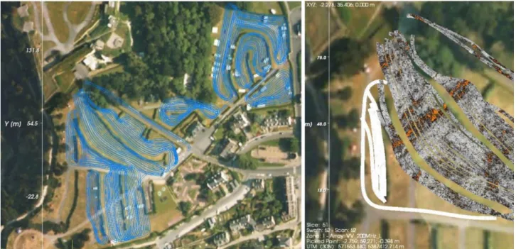
In January 2015, several archaeological structures (on the terrestrial and intertidal domain), previously excavated by the CeRAA team were scanned (Fig. 8). The scans were performed with a FARO Focus3D X330 particularly on the remains of an old retention pond which allowed, thanks to an ingenious pumping system, to provide potable water to the City.
(a)
(b)
Figure 8: 3D laser scanning survey of the Alet seashore: a) data acquisition; b) 3D point cloud.
We obtained a colored pointcloud containing 3,386290 points (Fig. 8b) that we converted into a mesh with the software Cloudcompare v. 2. It was then sub-sampled by post-processing for convenience up to 1 million faces (Fig. 9).
Figure 9: 3D mesh of the seashore.
2.9. Architectural references
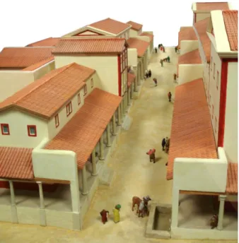
With the exception of the cathedral area, the archaeological excavations do not provide information about the apperance of the City from architectural and urbanistic points of view. However, two districts of the City of Corseul (Monterfil and Clos-Mulon), close to the City of Alet, are well-known by researchers and served as a model (Fig. 10) to propose a reconstitution of the civil buildings.
Figure 10: Manufactured model of the district of Monterfil in Corseul (doc. Corseul Archaeological Society Museum/H.
Paitier).
The military role of the City, as attested by the Notitia dignitatum (Clemente, 1968), involved representing characteristic buildings such as barracks and storehouses. Some typological studies based on many sites (Reddé, 2006) allow the reconstitution of the military areas (Fig. 11).
Figure 11: The Castellum of Aleto in Notitia Dignitatum (Mas. Lat. 9661, fol. 139 BNF).
2.9.1. Ground Penetrating Radar (GPR)
Alongside terrestrial laser scanning, we also tried, in June 2015, to detect buried remains. We used a Stream
3D MODEL AS A DYNAMIC COMPILATION OF KNOWLEDGE: INTERIM RESULTS ON THE CITY OF ALET
Virtual Archaeology Review, 8(16): 51-60, 2017 55
EM which is a multichannel GPR solution dedicated to utility locating and mapping (Conyers, 2012). The results, difficult to read because of bomb craters from the Second World War, are studied and evaluated (Fig. 12). Currently, we can say that there is a foreseeable structure, but it is not possible to determine its nature and thus to integrate it in the reconstitution.
3. Reconstitution process
3.1. Compiling the historical and archaeological data
Located in the protected area of the Normano-Breton gulf, the site occupies a strategic position, at the mouth of the river Rance, where potentially converge maritime, fluvial and terrestrial roads. This explains why historians and archaeologists have long turned their interest to this site, as it was considered to have played a decisive part in the regional history (pre-Roman economy and peopling, cross Channel trade, etc.).
The settlement appeared around 80 BC and survived to the Roman conquest, until the town was destroyed by fire around 25 AD. The remains of the pre-Roman town were found in different parts of the promontory that has all the characteristics of a blocked rocky spur. The archaeological excavations have yielded remains of wooden habitats, storage pits, dumps characterized by numerous elements of evidences and artefacts (ceramics, jewellery, grinders, coins...).
Under the influence of the Romans, a new town installed inland in Corseul (Fanum Martis) developed as the new capital of the Coriosolites, at the expense of the city of Alet, which disappeared from the map as a town and lost its political influence! Then, Alet only remained an important maritime station (known under the name of Reginca), with its port linking the river and maritime shipping and supplying the merchant ships, especially with fresh water (as documented by the discovery of an impressive wooden pump of 1500 kg).
Around 270 AD, insecurity from the sea led to a reactivation of the promontory of Alet, which was
surrounded by a rampart of 1800 m, punctuated by towers; the enclosed space was structured with a few streets and the access was provided by two doors. Sheltered from the ramparts, the activity of the Reginca harbor developed. In the middle of the 4th century AD, a
natural event occurred, i.e. the breakthrough of the alluvial cord which supported the landing harbour; then, the sea invaded the Solidor and Saint-Père coves. The waterworks pumping installation had to be abandoned and burial necropolis was invaded by the seawater. The Solidor rock and its fort acquired a strategic value (protection of the new harbor located in the Saint-Père cover and the lower part of the walls and the population of Alet increased. Around 380 AD, the centre of the city was destroyed to accommodate the Principia (headquarters) of a troop of soldiers (Martenses). Following the departure of the Roman administration, the city was temporarily abandoned around 420 AD, but continued to develop during the following centuries, with several famous episodes of war and religious history marking out the medieval and modern periods.
Figure 12: Area in Alet covered with the GPR and results in the southwest zone with z= -0.4 m.
Figure 13: Reginca location on a 'Peutinger Map' reproduction
The archaeological excavations carried out between 1971 and 1985 by L. Langouët at the foot of the promontory of Alet, helped to locate the Roman port of Reginca which is mentioned in the 'Peutinger Map' (Fig. 13), a medieval copy of an ancient road document. Located at the junction of several river and sea routes, the site of Reginca occupies a prominent place in the Normano-Breton Gulf, which is extended by the Rance and stands as a major traffic artery to penetrate far into the inland region. The artefacts found during the excavation, show diverse and sometimes remote origins which attest commercial activities throughout antiquity.
3.2. Representation: what, how and why?
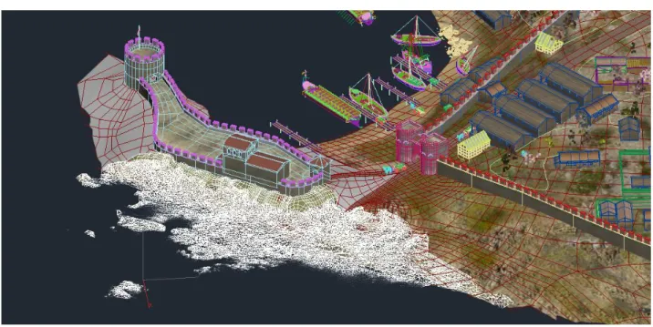
The aim of our work was not only to provide a view of the Alet city at one period, but also to illustrate the environmental and physical evolution of the site. Indeed, archaeological research not only provided elements of the culture and chronology of the site but also a set of evidences that, in terms of geomorphology, indicate that there has been important changes during, at least, the first centuries of the era. A precise drawing of this part of the site has been possible thanks to the 3D laser scanning of the remaining seashore structures (Fig. 16). With the large volume of textual data and images (Fig. 14 and 15) from several decades of archaeological research, a 3D reconstruction work could begin. This was done with 3ds Max 2015/VRay 3 and involved both buildings and vegetation. Regarding vegetation, we chose to use the Xfrog Plant Library (Müller, 2005; Kirchoff, 2009) and the scattering plugin Forest Pack (Mach, 2008). This plugin provides a complete solution for creating vast areas of objects, from trees and plants to ground-cover, rocks and more.
The representation of the harbour activity needs to integrate ships into the reconstitution. It means considering, on the one hand, ships for transport, maritime and river trade. On the other hand, there were also armed boats due to the military vocation of the Castellum.
The alluvial cordon failure, evidenced by archaeology and geomorphology was considered for the
reconstructions (Figs. 17 and 19). We could then illustrate not only the landscape evolution but also the evolution of the installation: at the foot of the tower Solidor, a necropolis was first installed during the Gallo-Roman period, probably during the 4th century, in a place
that is today a beach. According to the pattern of evolution of the paleo geographical site, the main event was the break of the alluvial cordon (Fig. 18), protecting
Figure 14: Nautical chart fragment drawn in 1695 (Dos, 1969)
mapping the ancient Alet city.
Figure 15: Assumed Alet Roman castellum from archaeological research data.
Figure 16: Mesh resulting from the laser scanning survey of the seashore archaeological features (white object) included in the 3D model of the city.
3D MODEL AS A DYNAMIC COMPILATION OF KNOWLEDGE: INTERIM RESULTS ON THE CITY OF ALET
Virtual Archaeology Review, 8(16): 51-60, 2017 57
land and installations located around a retro coastal marsh from the sea and river water floods. Due to these changes and invasion of the cove by the sea, the harbour and landing port had to move.
3.3. Discussion upon the graphic synthesis
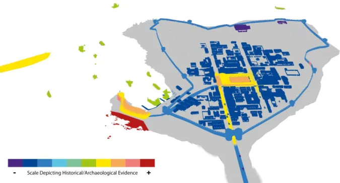
In addition to our reconstitution, we used a graphical representation of the amount of historical/archaeological evidence of elements represented (Fig. 20). The scale of colours is adapted from the project Byzantium 1200 (Öner & Berger, 1998) and from a table which represents the grade of evidence for the representation of elements in virtual archaeology. Colours correspond with the amount of evidence that range from "Imagination" (R120 G54 B140) to "Still existing in original form" (R183 G25 B24) through "Detailed graphical reference" (R175 G202 B11) (Resco & Figueiredo, 2014).
4. Conclusion and future works
4.1. 3D model as a dynamic compilation of knowledge
This first 3D reconstruction of the City of Alet provides a synthesis of archaeological knowledge accumulated over many years. Because it was done within an archaeology laboratory, it was directly monitored and controlled iteratively by researchers in the field (site, area and period).
From this experience of 3D laser scanning and reconstructions, the reflexion turns now to the limits and constraints regarding the scientific process. 3D reconstructions generate discussion between specialists and even renew the archaeological issues with new
Figure 18: Mapping of the Alet main features before and after the break of the alluvial bar (4th century AD), according to the
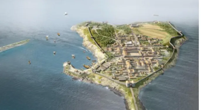
archaeological and geomorphological data. Figure 17: Reconstitution of the Ancient city and port of Alet, after the break of the alluvial cordon during the 4th century AD
(doc. Y. Bernard, CNPAO, CCC’s project).
Figure 19: Reconstitution of the Ancient city and port of Alet, before the break of the alluvial cordon during the 4th century AD
questionings. They could help to understand organisational aspects of the city and its people. Nevertheless, the CCC’ project experience confirmed that the renewal of communication supports corresponds to an expectation of the public. Bearing this in mind, we find it important to link the synthesis images to a graphical commentary system such as an historical/archaeological level of evidence scale that allows a distance from these reconstitutions.
We hope also that the scientific mediation work can build enthusiasm among policy makers and that they would allow therefore new archaeological studies and excavations. The results would feed consequently the reconstitution.
The 3D reconstitutions developed from a wide range of data synthesize the state of knowledge at any given time. The sense of affirmation caused by the photo-realistic rendering can be qualified by the graphical commentary system highlighted above. 3D files that make up the scene can be modified to adapt the new contributions and scientific discoveries.
4.2. Future works: the 3D reconstruction applied to ancient/roman armorican cities
The Alet case study presented above can be considered as a preliminary work, essential in the improvement of the methodological process. Our aim is now to develop such approach in a wider geographical and cultural scope, covering the territory or Armorica (i.e. Western France area during the Roman Empire); our objective will be to propose 3D reconstructions of the main Roman cities, in order to allow a comparative approach within the very large frame work of the Roman Empire territory.
Acknowledgements
The CCC’ project is co-funded by the Creative Europe Programme of the European Union. It is led by the MAT (Maritime Archaeology Trust, Southampton, UK) and involves the Prehistory Department of the Universtiy of Cantabria (Santander, Spain), and the CReAAH (Centre de Recherche en Archéologie, Archéosciences, Histoire, Rennes, France). We also want to thank the company ABEM France for the loan of the Stream EM multichannel GPR used in Alet.
References
Beacham, R. (2011). Concerning the Paradox of Paradata. Or, “I don’t want realism; I want magic!”. Virtual Archaeology Review 2(4), 39–43. http://dx.doi.org/10.4995/var.2011.4550
Bernard, Y., Barreau, J.B., Bizien-Jaglin, C., Quesnel, L., Langouët, L., & Daire, M.Y. (2016). 3D digitisation and reconstruction of a capital in northwestern Gaul: interim results on the city of Alet. In Proceedings of the 8th International Congress on Archaeology, Computer Graphics, Cultural Heritage and Innovation ‘ARQUEOLÓGICA 2.0’, (pp. 438-440). Valencia, Spain. http://dx.doi.org/10.4995/arqueologica8.2016.4479
Bonino, M. (1985). Sewn boats in Italy: sutiles naves and barche cucite. In S. McGrail/E. Kentley (Ed.), Sewn plank boats. Conference at Greenwich 1984, (pp. 87–104). British Archaeological Reports (Oxford).
Figure 20: Ranking of the reconstitution. This rendering shows the city as colour coded according to the grade of historical/archaeological evidence on Alet city. (Doc. Y. Bernard, CNPAO, CCC’s project).
3D MODEL AS A DYNAMIC COMPILATION OF KNOWLEDGE: INTERIM RESULTS ON THE CITY OF ALET
Virtual Archaeology Review, 8(16): 51-60, 2017 59
Ch'ng, E., Stone, R. J. (2006). 3D archaeological reconstruction and visualisation: An artificial life model for determining vegetation dispersal patterns in ancient landscapes. In International Conference on Computer Graphics, Imaging and Visualisation (CGIV'06), (pp. 112–118). Sydney, Australia. http://dx.doi.org/10.1109/cgiv.2006.2
Chaumet, A. (2008). Webmapping, archéologie et Géoportail. Archeologia e calcolatori 19, 79–86.
Conyers, L.B. (2012). Interpreting Ground-penetrating Radar for Archaeology. Left Coast Press. http://dx.doi.org/10.5860/choice.50-5075
Christen, M., & Nebiker, S. (2015). Visualisation of complex 3D city models on mobile webbrowsers using cloud-based image provisioning. ISPRS Annals of Photogrammetry, Remote Sensing and Spatial Information Sciences, 2-3/W5, 517–522. http:// dx.doi.org/10.5194/isprsannals-ii-3-w5-517-2015
Clemente, G. (1968). La "Notitia Dignitatum" (Vol. 4). Editrice sarda Fossataro.
Dietrich, A., Gebhardt, A., & Marguerie, D. (2003). Le sanctuaire du second Age du Fer des Sept-Perthuis. Etude archéo-environnementale. Revue archéologique de l’Ouest, supplément n°10. 141–148.
Dos, A. (1969). Cinq campagnes de fouilles archéologiques à la Cité d'Alet à Saint-Servan-sur-Mer. Annales de Bretagne, 76, 1, 229–245. http://dx.doi.org/10.3406/abpo.1969.2515
Dylla, K., Frischer, B., Müller, P., Ulmer, A., & Haegler, S. (2008). Rome reborn 2.0: A case study of virtual city reconstruction using procedural modeling techniques. Computer Graphics World, 16, 62–66
Johnston, M. (2015). Trees in Towns and Cities: A History of British Urban Arboriculture. Casemate Publishers.
Kirchoff., A., Paar, P., & Mülder, J. (2009). Die virtuelle Rekonstruktion von Herodes’ drittem Winterpalast und der Oase von Jericho. Hefte des Archäologischen Seminars der Universität Bern, 51–161.
Langouët, L. (1973). Les fouilles d'Alet en 1973. Saint-Malo: Dossiers du Centre Régional d'Archéologie d'Alet.
Langouët, L. (1975). Les Corsiolites, un peuple armoricain. Supplément aux Dossiers du Centre Régional d'Archéologie d'Alet, 77–85.
Langouët, L. (1976). Alet ville ancienne. Saint-Malo: Dossiers du Centre Régional d'Archéologie d'Alet.
Langouët, L. (1980). Les oppida pré-romains des Corsiolites. In Actes du 105ème congrès national des Sociétés Savantes, (pp. 255–266). Caen, France
Langouët, L. (1987). Les fouilles archéologiques de la zone des cathédrales d'Alet. Saint-Malo: Dossiers du Centre Régional d'Archéologie d'Alet.
Langouët, L. (1996). La cité d'Alet: de l'agglomération gauloise à l'île de Saint-Malo. Saint-Malo: Dossiers du Centre Régional d'Archéologie d'Alet.
Mach, R. (2008). Visualization in support of landscape design. In K. von Gadow & T. Pukkala (Eds.), Designing Green Landscapes (pp. 265–286). Dordrecht: Springer Netherlands. http://doi.org/10.1007/978-1-4020-6759-4_11
Miller, C. (1887). Castori Romanorum Cosmographi - tabula quae dicitur Peutingeriana. Retrieved March 8, 2016, from http://www.doria.fi/handle/10024/90222.
Müller, P., Vereenooghe, T., Ulmer, A., & Van Gool, L. (2005). Automatic reconstruction of Roman housing architecture. In Recording, Modeling and Visualization of Cultural Heritage: Proceedings of the International Workshop, (pp. 287– 298). Ascona, Switzerland
Noghani, J., Anderson, E. F., & Liarokapis, F. (2012). Towards a Vitruvian Shape Grammar for Procedurally Generating Classical Roman Architecture. In Proceedings of the 13th International Symposium on Virtual Reality, Archaeology and Cultural Heritage VAST (pp. 41–44). Brighton, UK
Öner, A.T., & Berger, A. (1998). Byzantium1200 project. Retrieved August 6, 2013, from http://www.byzantium1200.org Pomey, P., Rieth, E., & Rival, M., (2005). L'archéologie navale. Errance.
Reddé, M., Brulet, R., Fellmann, R., Haalebos, J. K. & Von Schnurbein, S. (Eds.) (2006). L'architecture de la Gaule romaine. Les fortifications militaires. Paris: Éditions de la Maison des sciences de l'homme.
Resco, P. A., & Figueidero, C. (2014). Escala de evidencia histórica | Scale of historical evidence. Retrieved January 10, 2015, from https://parpatrimonioytecnologia.wordpress.com/2014/07/21/escala-de-evidencia-historica-scale-of-historical-evidence
Sars, K. (2011). Sars Houtbouw - Historische reconstructies en ambachtelijk timmerwerk - Romeinse liburna. Retrieved April 8, 2016, from http://www.sarshoutbouw.nl/liburna.html
Vergnieux, R. (2011). Archaeological research and 3D models (Restitution, validation and simulation). Virtual Archaeology Review, 2(4), 39–43. http://dx.doi.org/10.4995/var.2011.4546