Vulnérabilité des tanières du renard arctique aux aléas
géologiques reliés aux changements climatiques
Mémoire présenté
dans le cadre du programme de maîtrise en gestion de la faune et de ses habitats en vue de l’obtention du grade de maître ès sciences
PAR
© Florence Lapierre Poulin
Composition du jury :
Francis Gauthier, président du jury, Université du Québec à Rimouski
Dominique Berteaux, directeur de recherche, Université du Québec à Rimouski Daniel Fortier, codirecteur de recherche, Université de Montréal
Marie-Andrée Giroux, examinatrice externe, Université de Moncton
UNIVERSITÉ DU QUÉBEC À RIMOUSKI Service de la bibliothèque
Avertissement
La diffusion de ce mémoire ou de cette thèse se fait dans le respect des droits de son auteur, qui a signé le formulaire « Autorisation de reproduire et de diffuser un rapport, un mémoire
ou une thèse ». En signant ce formulaire, l’auteur concède à l’Université du Québec à
Rimouski une licence non exclusive d’utilisation et de publication de la totalité ou d’une partie importante de son travail de recherche pour des fins pédagogiques et non commerciales. Plus précisément, l’auteur autorise l’Université du Québec à Rimouski à reproduire, diffuser, prêter, distribuer ou vendre des copies de son travail de recherche à des fins non commerciales sur quelque support que ce soit, y compris l’Internet. Cette licence et cette autorisation n’entraînent pas une renonciation de la part de l’auteur à ses droits moraux ni à ses droits de propriété intellectuelle. Sauf entente contraire, l’auteur conserve la liberté de diffuser et de commercialiser ou non ce travail dont il possède un exemplaire.
« Voici mon secret. Il est très simple : on ne voit bien qu'avec le cœur. L'essentiel est invisible pour les yeux. »
‒ Le renard dans Le Petit Prince, d’Antoine de Saint-Exupéry
REMERCIEMENTS
Pour ceux et celles qui n’y croyaient pas : C’est fait, j’ai déposé ! Et en un temps record ! Les personnes mentionnées dans ces remerciements comprendront la blague.
Je tiens premièrement à remercier mon directeur Dominique. Merci d’abord et avant tout de m’avoir donné la chance d’accomplir l’un de mes plus grands rêves, celui de partir en expédition en Arctique. Et cinq fois plutôt qu’une ! Merci pour ton immense patience et l’expression de ta confiance à travers les grandes responsabilités que tu m’as confiées sur le terrain. Merci d’avoir canalisé mes réflexions scientifiques dans une seule direction alors que mes idées s’éparpillaient et d’avoir été aussi disponible, mais de façon tranquille, sans pression. Tu as été le superviseur idéal pour me guider dans cette maîtrise.
Merci aussi à mon co-directeur Daniel pour son enthousiasme débordant ! Merci pour ton expertise qui m’a fait redécouvrir les paysages de Bylot à travers tes yeux de géomorphologue. Grâce à toi je peux maintenant dire que j’aime les roches. Merci pour les beaux moments passés ensemble sur le terrain et à la brûlerie de Limoilou à se parler de science, mais aussi des grandes questions de la vie à un moment où j’en avais particulièrement besoin. Je me souviendrai toujours du moment où tu t’es arrêté de parler dans ladite brûlerie en regardant autour de toi : « Ayoye…on est don bin deep ».
Je remercie sincèrement les nombreux organismes subventionnaires sans qui ce projet de recherche n’aurait pas pu être réalisé. Leur contribution est mentionnée à la fin de l’article présenté dans ce mémoire.
Merci à Alain Caron et Nico Casajus pour l’aide en statsistiques et la résolution des problèmes avec R. Grâce à vous, R et moi on garde une belle relation.
x
Je n’aurais pas pu souhaiter meilleurs partenaires que mes coéquipiers/ières de l’équipe renard à Bylot pour vivre d’aussi folles aventures ! Merci à Jo, Bradette et Clément de m’avoir prise sous votre aile et de m’avoir transmis votre passion. Rappelez-vous qu’on a failli y passer (ça bouille dans l’tuyau). Les gars, vous êtes mes bros. Merci à Clem, Fred et Mag pour l’été suivant. Les bed-ins et les games de cartes interminables en mangeant du pain pendant le blizzard de 5 jours étaient magiques. Votre folie et mon triple-menton aussi. Un gros merci encore à Mag, David et Kate, je ressens des bouffées d’amour quand je pense à vous ! Beaux souvenirs de skidoo en cagoule/combine/crocs à -15ºC juste pour le style, et de noms de renards les plus funky qui soient (pogne, pêh, pwé, señor puel, bungee, ti-brun, anti, mémé zinzin) ! Ariane, Ben, Justine, merci de m’avoir acceptée dans votre clan des BBNGB après que je sois arrivée à la mi-saison. On a fini par l’avoir le p’tit maudit ! Ariane, Jade, Sarah et Sandra, merci d’avoir partagé avec moi cette dernière saison à Bylot, l’été de l’équipe de filles ! Vous êtes des femmes magnifiques et j’aurais aimé terminer la saison avec vous (comme vous avez pu le voir à mon air peiné quand je suis partie…). Merci aussi aux autres équipes de Bylot et aux employés de PCSP à Resolute ! Clin d’œil à Yvon et Tim.
Je tiens aussi à remercier les gens du labo. Merci à tout le monde pour les discussions scientifique/sociales et les desserts le vendredi midi quoique me bourrer de gâteau n’ait pas toujours été la meilleure idée pour ma productivité du vendredi après-midi.
Merci à mes colocs, à Gab Montpetit (a.k.a. Gambolini) pour la session passée ensemble dans la petite maison des wizz-swizz. Merci à mes colocs de Drewitt, la maison du bonheur !!! Mag, Camille, Kristen, Anne-Mathilde, Kingait, ça a été une pure joie de partager votre quotidien. Merci de m’avoir nourrie, non seulement de vos bons petits plats, mais aussi de votre bonne humeur et de vos rires contagieux.
Je voudrais remercier mes amis. Les anciens et les nouveaux, ceux qui sont partis et ceux qui sont restés. Je ne saurais nommer tout le monde et je vais donc me restreindre aux personnes les plus importantes. Merci à mes sistas Isa et Jess d’être là. Malgré la distance géographique qui nous sépare, votre amitié est inestimable et vous êtes dans mon cœur, tout le temps. Merci à Marie-Pier, the sweetest sunshine, d’avoir été là pour foncer avec moi tête
travers, merci mon amie. Dédé, Mathieu, Jo Frenette, Ariane, Phil, vous avez joué des rôles importants pour moi chacun à votre façon, merci pour votre écoute et merci d’être aussi drôles !
J’offre aussi mes remerciements à Roger, mon entraîneur de badminton, ainsi qu’à tous les membres de l’équipe de badminton du Nordet-UQAR. Merci Roger d’avoir vu le potentiel en moi quand je ne savais pas comment tenir ma raquette (j’y travaille encore !) et de m’avoir donné la chance de me développer dans un sport qui m’a permis de conserver une bonne santé physique et mentale pendant les dernières années. Tu es pour moi une inspiration.
Un immense merci à ma famille Lapierre-Poulin au grand complet de qui j’aimerais être plus proche parfois (la Beauce c’est loin, surtout l’hiver). Je tiens à souligner votre appui inconditionnel pendant ces dernières années ainsi que la chance que j’ai de vous avoir. Merci de vous intéresser à ce que je fais et de ne pas me demander pourquoi je suis encore aux études à mon âge. Un merci spécial à ma sœur Justine, avec qui je peux me permettre d’être moi-même à 100%. Merci pour ta franchise sans détour (« t’es laitte »), et merci pour les souvenirs qu’on aime se remémorer et que je ne pourrais partager avec personne d’autre. Je ne saurais trouver de mots assez forts pour remercier mes parents, Suzie et Éric, qui m’encouragent dans tout ce que j’entreprends. Merci maman d’avoir stimulé ma curiosité depuis que je suis toute petite, de m’avoir traînée à des spectacles et de m’avoir inscrite à toutes les activités possibles. Tu m’as donné tout ce qu’il fallait et bien plus pour que j’en arrive là. Merci papa pour ta grande écoute, ta compréhension et tes bons conseils. Tu es mon phare. Je vous aime infiniment et vous dois une bonne partie de ce mémoire.
Merci finalement au plus beau, Clément ! Merci pour ton support à toute épreuve même dans les périodes de stress et merci de croire en moi. Merci par-dessus tout de me faire rire à tous les jours, c’est un bonheur d’avancer avec toi. Maintenant que nous avons déposé, à nous la vie !
RÉSUMÉ
Les changements climatiques augmentent les risques d’altérations sévères des habitats essentiels de nombreuses espèces animales, surtout dans l’Arctique. Le renard arctique (Vulpes lagopus) utilise des tanières comme refuges contre les grands froids et les prédateurs. Ces tanières, creusées dans la couche supérieure du pergélisol (couche active), sont essentielles pour l’élevage des jeunes et sont réutilisées d’une génération à l’autre. Nous avons testé l’hypothèse selon laquelle, en raison du réchauffement climatique, l’augmentation de la fréquence des aléas géologiques comme le tassement au dégel, les mouvements de masse et l’érosion thermique est une menace sérieuse à la stabilité de ces tanières. Sur l’Île Bylot (Nunavut, Canada), nous avons développé un indice de vulnérabilité qualitatif des tanières à ces aléas. Cet indice a été calculé à partir d’observations de terrain et de photos aériennes obliques. Parmi les 106 tanières étudiées, 14% ont été classées comme très vulnérables alors que 17% et 69% ont été classées comme modérément ou faiblement vulnérables, respectivement. La vulnérabilité n’était pas significativement reliée à la probabilité d’utilisation pour la reproduction. Les changements climatiques affectent donc les tanières de renards arctiques, mais sans qu’ils soient un risque majeur pour l’espèce à notre site d’étude. Notre recherche est la première à donner un aperçu de l’impact des aléas géologiques reliés aux changements climatiques sur l’écologie du renard arctique. La méthode proposée est flexible et pourrait être appliquée, dans un cadre de conservation ou de recherche fondamentale, à d’autres sites ou d’autres espèces qui dépendent directement du pergélisol durant leur cycle vital.
Mots-clés : Vulpes lagopus, vulnérabilité, aléas géomorphologiques, changements climatiques, pergélisol
ABSTRACT
Climate change increases the risk of severe alterations to essential habitats for wildlife species, especially in the Arctic. The Arctic fox (Vulpes lagopus) uses dens as shelters against cold temperatures and predators. These dens, which are needed for successful reproduction, are dug in the top layer of permafrost (active layer) and reused across multiple generations. We tested the hypothesis that due to climate change, the increasing frequency of geohazards like thaw settlement, mass movements, and thermal erosion is a serious threat for the long-term stability of Arctic fox dens. On Bylot Island (Nunavut, Canada), we developed a qualitative vulnerability index to geohazards for Arctic fox dens. The index was calculated from field observations and oblique aerial photographs. Of the 106 dens studied, 14% were classified as highly vulnerable while 17% and 69% had a moderate and low vulnerability, respectively. Vulnerability was not significantly related to the probability of use for reproduction. While climate change will impact Arctic fox reproductive structures, we conclude that this is not a major threat to the species in our study area. Our research is the first to provide insights into the climate-related geohazards potentially affecting Arctic fox ecology. The developed method is flexible and could be applied, for conservation or basic research, to other study sites or other species depending directly on permafrost for part of their life cycle.
TABLE DES MATIÈRES
REMERCIEMENTS ... ix
RÉSUMÉ ... xiii
ABSTRACT ... xv
TABLE DES MATIÈRES ... xvii
LISTE DES TABLEAUX ... xix
LISTE DES FIGURES ... xxi
LISTE DES ABRÉVIATIONS, DES SIGLES ET DES ACRONYMES ... xxiii
INTRODUCTION GÉNÉRALE ... 1
CHAPITRE 1 Faible vulnérabilité des tanières du renard arctique aux aléas géologiques reliés aux changements climatiques sur l’Île Bylot, Nunavut ... 9
1.1 RESUME EN FRANÇAIS DE L’ARTICLE ... 9
1.2 LOW VULNERABILITY OF ARCTIC FOX DENS TO CLIMATE CHANGE-RELATED GEOHAZARDS ON BYLOT ISLAND,NUNAVUT ... 11
1.3 ABSTRACT ... 11 1.4 INTRODUCTION ... 12 1.5 METHODS ... 14 1.6 RESULTS ... 19 1.7 DISCUSSION ... 20 1.8 CONCLUSION ... 22 1.9 ACKNOWLEDGMENTS ... 24 1.10 REFERENCES ... 25 1.11 FIGURES ... 34
xviii
1.12 SUPPLEMENTARY MATERIAL ... 38
CONCLUSION GÉNÉRALE ... 47 RÉFÉRENCES BIBLIOGRAPHIQUES ... 51
LISTE DES TABLEAUX
Table S1. Pairwise comparison matrices for thaw settlement (a), mass movements (b), and thermal erosion (c). The weights are calculated by dividing the principal
eigenvector with the sum of its components. ... 38 Table S2. Local geomorphology and characteristics of 106 arctic fox dens, their
relative vulnerability indexes (RVI) associated to thaw settlement (ts), mass movements (mm), and thermal erosion (te), and their overall vulnerability index
LISTE DES FIGURES
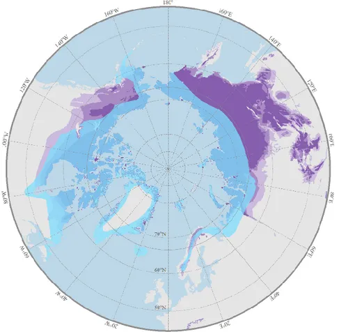
Figure 1. Aire de répartition circumpolaire du renard arctique (bleu foncé). Carte
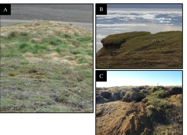
effectuée à l’aide de la bibliothèque « OpenStreetMap » dans R (Fellows 2016). ... 3 Figure 2. Les tanières de renards arctiques sont souvent situées sur des buttes et sont habituellement faciles à repérer en raison de la végétation qui les recouvre et est plus verte qu’aux alentours (A). Jeunes renards à la tanière (crédit photo : Magaly Oakes) (B). Les tanières sont généralement des réseaux de tunnels creusés dans la toundra
(C). ... 5 Fig. 1. Geographical distribution of continuous permafrost (dark purple),
discontinuous permafrost (purple), sporatic permafrost (light purple), and Arctic fox (transparent blue). Permafrost distribution from Brown et al. (2002) and Arctic fox
distribution from IUCN (2014). ... 34 Fig. 2. Vulnerability computation framework for Arctic fox dens facing climate
change-related geohazards on Bylot Island, Nunavut. An Overall Vulnerability Index (OVI) is calculated by adding the Relative Vulnerability Index (RVI) associated with each of three geohazards, namely thaw settlement (green), mass movements (blue) and thermal erosion (purple). Each RVI is calculated from three to four indicators reflecting ground ice content, slope gradient and erosion. Weights (0 = no
importance, 1 = very high importance) attributed to the various indicators for each geohazard appear in the coloured circles, while scores (0 = no relevance to
vulnerability, 1 = high relevance to vulnerability) attributed to the various levels of
each indicator appear in the grey circles. Adapted from Kappes et al. (2012). ... 35 Fig. 3. Distribution of Arctic fox dens (n = 106) on the South Plain of Bylot Island,
Nunavut, Canada. Colors show the vulnerability of dens to climate chance-induced geohazards (green = low vulnerability, yellow = moderate vulnerability, red = high
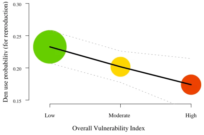
vulnerability). ... 36 Fig. 4. Probability of den use for reproductive purposes in relation to the global
vulnerability index. Dashed lines are the 95% confidence interval. Each circle
xxii
size is proportional to the number of observations: green = 1022, yellow = 255, red = 269). ... 37 Fig. S1. Examples of the indicators evaluated on each den: surficial deposit as a
proxy of ground ice content (A = fine sand and silt, B = coarse sand and gravel), presence of thermal erosion (C), presence of tension cracks (D), and presence of
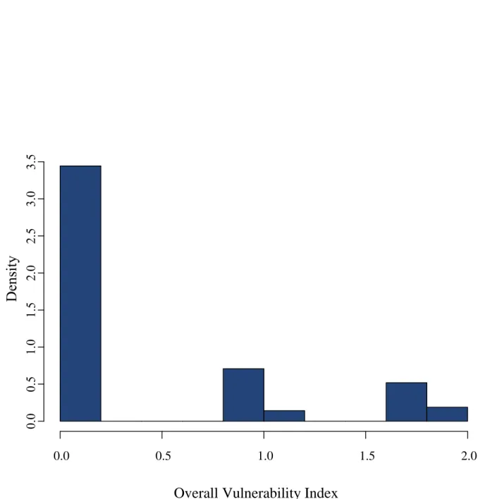
ice-wedge polygons and erosion (E). ... 44 Fig. S2. Frequency distribution of the overall vulnerability index. Based on this
histogram, the threshold values for differentiating the three levels of vulnerability
LISTE DES ABRÉVIATIONS, DES SIGLES ET DES ACRONYMES
ACIA Arctic Climate Impact Assessment AHP Analytical hierarchy process.
AMAP Arctic Monitoring and Assessment Programme CAFF Conservation of Arctic Flora and Fauna
IBVA Indicator-based vulnerability assessment. IPCC Intergovernmental Panel on Climate Change. IUCN International Union for Conservation of Nature OVI Overall vulnerability index
INTRODUCTION GÉNÉRALE
Contexte général
Dans son dernier rapport, le Groupe d’experts intergouvernemental sur l’évolution du climat (GIEC) confirme une fois de plus que le réchauffement du système climatique est un phénomène bien réel qui se produit à un rythme alarmant depuis les années 1950 (IPCC 2013). Les conséquences d’un tel bouleversement sont nombreuses et incluent entre autres l’augmentation des températures de l’air et des océans, la diminution de la surface de glace de mer, la hausse du niveau des océans et l’augmentation de la fréquence et de l’importance des aléas géologiques. Un aléa géologique est un phénomène naturel pouvant être de nature géologique (ex. tremblement de terre, glissement de terrain, érosion côtière) ou encore relié au système atmosphérique (ex. tornade, canicule, blizzard), qui risque d’altérer un système de façon négative (Kusky 2003). Bien que les conséquences des changements climatiques soient observables un peu partout sur la planète, les environnements nordiques sont les plus fortement touchés en raison des nombreux processus de rétroaction positive qui amplifient le réchauffement dans les hautes latitudes (Pithan et Mauritsen 2014). À titre d’exemple, la température moyenne à la surface de la Terre a subi un réchauffement deux fois plus important en Arctique que la moyenne globale dans les 50 dernières années (AMAP 2017). D’après les prédictions du dernier rapport de l’Arctic Climate Impact Assessment (ACIA 2005), une augmentation de 4 à 7˚C de la température moyenne en Arctique est attendue au cours du siècle actuel, ainsi qu’une augmentation de la fréquence des précipitations (dont une plus grande proportion sous forme de pluie) et une possible augmentation de la fréquence des tempêtes selon les régions.
L’une des conclusions majeures de l’Arctic Biodiversity Assessment (CAFF 2013) est que les changements climatiques sont incontestablement la plus grande menace pour la
2
biodiversité arctique. De fait, les changements climatiques peuvent avoir un impact direct sur certains groupes d’espèces particulièrement sensibles aux variations de température et de précipitations, comme les plantes. À l’inverse, les mammifères et les oiseaux sont des homéothermes (avec régulation interne de la température) qui sont généralement considérés comme étant plus résilients aux effets directs, mais tout aussi sensibles aux effets indirects des conditions météorologiques et climatiques (Gauthier et al. 2011). Ces derniers comprennent notamment les modifications dans l’abondance et la répartition de la nourriture (Gilg et al. 2009), les interactions avec de nouvelles espèces compétitrices (Gallant et al. 2014; Elmhagen et al. 2017), prédatrices (Pamperin et al. 2006) ou parasites (Parkinson et Butler 2005), et l’altération des structures utilisées comme refuges (Beardsell et al. 2017). Ce tout dernier cas est peu étudié et mérite pourtant d’être approfondi puisque de nombreuses espèces dépendent de la stabilité de tels refuges pour accomplir des étapes cruciales de leur cycle de vie, comme la reproduction. L’une des espèces emblématiques de l’Arctique, le renard arctique (Vulpes lagopus), est un parfait exemple pour mieux comprendre cette relation puisque son cycle de vie est étroitement lié à sa tanière.
Contexte écologique
Le renard arctique
Les renards arctiques ont une distribution circumpolaire (Figure 1) et sont les seuls prédateurs endémiques terrestres des régions arctiques (Macpherson 1969, Fuglei et Ims 2008). Ils possèdent plusieurs adaptations physiologiques leur permettant de survivre aux conditions sévères de leur environnement, entre autres des membres assez courts et une fourrure extrêmement dense qui possède des propriétés isolantes parmi les meilleures chez les mammifères (Prestrud 1991). Leur alimentation peut être composée de plusieurs espèces de vertébrés, mais deux stratégies alimentaires peuvent habituellement être observées au sein de l’espèce. Alors que les renards vivant à l’intérieur des terres se nourrissent principalement de lemmings (Lemmus spp. et Dicrostonyx spp.) tout en utilisant d’autres ressources
Figure 1. Aire de répartition circumpolaire du renard arctique (bleu foncé). Carte effectuée à l’aide de la bibliothèque « OpenStreetMap » dans R (Fellows 2016).
Tout comme chez les autres canidés, les jeunes renards naissent à la fin du printemps dans des tanières dont la fonction première est de fournir une protection contre les prédateurs (Eberhardt et al. 1983; Prestrud 1992a). Les renardeaux naissent aveugles et dépendent de leurs parents, qui les élèvent aux tanières pendant environ deux mois (Tannerfeldt et al. 2003). L’importance de ces structures pour les renards arctiques est d’autant plus capitale qu’ils évoluent dans des paysages très ouverts en raison de l’absence d’arbres et qu’ils doivent supporter des conditions climatiques rigoureuses (Tannerfeldt et al. 2003). L’accès à des tanières adéquates est donc essentiel à la reproduction, bien que celles-ci soient également utilisées comme abris par les adultes à longueur d’année (Prestrud 1992a, 1992b).
4
Description des tanières
Une tanière typique de renard arctique se présente généralement comme un réseau de galeries souterraines creusées dans la toundra et pouvant comprendre de quelques à plusieurs dizaines d’entrées (Figure 2). Les caractéristiques physiques des tanières sont bien documentées dans l’ensemble de l’aire de répartition du renard arctique et leur emplacement ne semble pas aléatoire. À l’exception des zones d’affleurement rocheuxcomme sur les côtes de l’archipel de Svalbard ou d’Islande, où elles sont situées sous des rochers, dans des éboulis ou dans des crevasses (Prestrud 1992a), les tanières sont généralement situées sur des buttes, des crêtes ou des pentes constituées de dépôts meubles (Sibérie : Danilov 1961, Fennoscandie : Østbye et al. 1978; Dalerum et al. 2002; Frafjord 2003, Groenland : Nielsen et al. 1994, Canada : Macpherson 1969; Smits et al. 1988; Smith et al. 1992; Szor et al. 2008, Alaska : Chesemore 1969; Garrott et al. 1983). Le relief de ces structures offre un bon drainage, ce qui protège les tanières contre les inondations, et leur exposition au vent favorise un faible couvert de neige en hiver, ce qui facilite leur accès (Macpherson 1969; Eberhardt et al. 1983; Prestrud 1992a; Smith et al. 1992; Szor et al. 2008). Le type de sol dans lequel sont creusées les tanières est habituellement composé de sédiments contenant une forte proportion de sable, puisque celui-ci, en plus de s’assécher rapidement, est peu compact et facilite le creusage (Macpherson 1969; Smits et al. 1988; Prestrud 1992a; Szor et al. 2008). La proximité des cours d’eau semble également être un facteur déterminant dans le choix d’un site de tanière, ce qui pourrait s’expliquer entre autres par l’utilisation intensive des berges par les lemmings (Szor et al. 2008). Les tanières sont habituellement faciles à repérer grâce à la végétation luxuriante qui les recouvre en raison de la concentration locale de matériel organique (fèces, carcasses, etc.) et de la bioturbation (mélange du sol) engendrées par l’activité des renards (Smits et al. 1988; Gharajehdaghipour et al. 2016).
Dans la majeure partie de l’aire de répartition du renard arctique, les tanières possèdent une caractéristique intéressante : elles sont excavées dans la couche active du pergélisol. Ce dernier est défini comme étant un sol (roc ou sédiments meubles incluant la glace et la matière organique contenues) demeurant sous 0˚C pendant plus de deux années consécutives (Van Everdingen 2005). D’ailleurs, la constitution du pergélisol (qui n’est pas seulement composé de glace et de neige) est la raison pour laquelle on devrait toujours parler de dégel et non de fonte lorsque le sujet est évoqué. Vers la fin de l’été, la couche supérieure du pergélisol (couche active) est soumise à un bref dégel saisonnier d’une épaisseur souvent inférieure à 50 cm en Arctique (Tannerfeldt et al. 2003), ce qui permet aux renards de creuser. La fenêtre de temps pour construire une tanière est donc relativement courte, et les sites potentiels sont restreints aux endroits où la couche active est suffisamment épaisse (Eberhardt et al. 1983).
Figure 2. Les tanières de renards arctiques sont souvent situées sur des buttes et sont habituellement faciles à repérer en raison de la végétation qui les recouvre et est plus verte qu’aux alentours (A). Jeunes renards à la tanière (crédit photo : Magaly Oakes) (B). Les tanières sont généralement des réseaux de tunnels creusés dans la toundra (C).
6
Au printemps, lorsque la couche active n’est pas encore dégelée, il est pratiquement impossible pour les renards de creuser de nouvelles tanières en vue de la reproduction (Frafjord 2003). Ils se servent donc de tanières déjà existantes, que des générations successives peuvent ainsi réutiliser pendant des siècles (Macpherson 1969).
Plusieurs études ont détecté une température plus élevée ainsi qu’une couche active jusqu’à deux fois plus épaisse aux tanières que dans le milieu environnant (Danilov 1961; Chesemore 1969; Østbye et al. 1978; Smits et al. 1988; Smith et al. 1992; Szor et al. 2008). Il semble qu’une plus grande ventilation causerait une descente du plafond du pergélisol, ce qui permettrait aux renards d’excaver un peu plus profondément chaque année (Tannerfeldt et al. 2003). Il s’avère donc plus profitable pour les renards d’utiliser des tanières dont le creusage est déjà entamé, puisque la descente progressive du plafond du pergélisol leur permet d’apporter une meilleure dimension verticale à l’abri. Au fil des ans, de nouveaux trous sont graduellement creusés par les jeunes et les adultes vers la fin de l’été, ce qui peut donner lieu à d’impressionnantes structures comportant plus d’une centaine d’entrées.
Contexte géomorphologique périglaciaire
Les environnements périglaciaires (c’est-à-dire les zones où la température annuelle moyenne est de moins de 3˚C) se caractérisent à la fois par l’action importante des cycles de gel-dégel et par la présence du pergélisol (French 2007). Ces deux éléments sont sensibles au réchauffement climatique, et le dégel du pergélisol est souvent le catalyseur d’importants aléas géologiques comme les glissements de terrain, les tassements au dégel, etc. (Slaymaker et al. 2009). L’ampleur des modifications créées dans le paysage par ces aléas est particulièrement élevée lorsque le pergélisol est très riche en glace (French 2007). En effet, comme l’eau augmente de volume lors du gel, les sédiments sur-saturés d’eau sont propices au soulèvement en réponse au gel. Ils sont donc également beaucoup plus sensibles au dégel, car la diminution de volume causée par le changement de phase glace-eau est souvent accompagnée d’un tassement des sédiments qui peut ensuite entraîner une subsidence à la
portions du sol qui risquent de glisser vers le bas des pentes sous l’effet de la gravité, ce qu’on appelle les mouvements de masse (French 2007). Un autre aléa géologique voué à s’intensifier en Arctique est l’érosion thermique (transfert d’énergie thermique et mécanique de l’eau vers le pergélisol). Comme les scénarios climatiques prédisent une hausse du niveau des rivières et des océans causée par une plus grande libération d’eau provenant de la fonte des neiges et des glaciers, les phénomènes d’érosion sont susceptibles d’augmenter sur les rives et près des côtes.
Problématique
L’augmentation des aléas géologiques est une menace directe pour la stabilité des tanières de renards arctiques, qui reposent sur le pergélisol. Sachant qu’il est difficile de creuser rapidement de nouvelles tanières et que les renards dépendent donc de la persistance de celles-ci pour obtenir un bon site de reproduction au printemps, nous avons décidé d’explorer l’effet indirect des changements climatiques sur le renard arctique via son impact direct sur les tanières.
Une diminution de la disponibilité de tanières présente un risque pour le succès reproducteur de l’espèce (Smits et al. 1988). Comme le renard arctique est un prédateur clé des écosystèmes arctiques, des changements dans son abondance pourraient avoir des répercussions sur les niveaux trophiques inférieurs (Bêty et al. 2002; Gharajehdaghipour et al. 2016).
8
Objectifs
Notre premier objectif était d’évaluer la vulnérabilité des tanières de renards arctiques aux aléas géologiques reliés aux changements climatiques (tassement au dégel, mouvements de masse et érosion thermique). Comme les renards arctiques ont tendance à sélectionner des structures topographiques élevées, des pentes et des bords de rivières pour établir leurs tanières, notre prédiction était qu’une majorité de tanières serait vulnérable.
Les tanières qui sont fréquemment utilisées pour la reproduction constituent seulement une faible proportion des tanières disponibles dans un même site (Prestrud 1992b; Anthony 1996). Szor et al. (2008) ont étudié les facteurs influençant le choix d’une tanière par rapport à une autre pour l’élevage des renardeaux à l’Île Bylot et ont trouvé que la distribution des ressources alimentaires est le facteur le plus influent, en mentionnant que d’autres variables physiques sont probablement en jeu. Comme les tanières de reproduction ont une importance cruciale pour le maintien des populations, notre second objectif était de déterminer si les tanières de reproduction sont plus vulnérables que les autres aux changements climatiques et leurs aléas géologiques associés.
Pour atteindre ces objectifs, nous avons d’abord développé une approche basée sur l’évaluation visuelle d’indicateurs de vulnérabilité. Ces évaluations ont été réalisées à l’aide de photographies aériennes obliques et de visites à pied de chacune des 110 tanières répertoriées sur l’Île Bylot dans le Haut arctique canadien (73° N, 80° O), au cours des étés 2014-2015. Elles nous ont permis de classer les tanières dans trois catégories de vulnérabilité différentes (faible, modérée, élevée). Par la suite, nous avons comparé l’indice de vulnérabilité de chaque tanière avec son historique de reproduction depuis 1993.
CHAPITRE 1
FAIBLE VULNERABILITE DES TANIERES DU RENARD ARCTIQUE AUX ALEAS GEOLOGIQUES RELIES AUX CHANGEMENTS CLIMATIQUES SUR
L’ÎLE BYLOT, NUNAVUT
1.1 RESUME EN FRANÇAIS DE L’ARTICLE
Les changements climatiques augmentent les risques d’altérations sévères des habitats essentiels de nombreuses espèces animales, surtout dans l’Arctique. Le renard arctique (Vulpes lagopus) utilise des tanières comme refuges contre les grands froids et les prédateurs. Ces tanières, creusées dans la couche active du pergélisol, sont essentielles pour l’élevage des jeunes et sont réutilisées d’une génération à l’autre. Nous avons testé l’hypothèse selon laquelle, en raison du réchauffement climatique, l’augmentation de la fréquence des aléas géologiques comme le tassement au dégel, les mouvements de masse et l’érosion thermique est une menace à la stabilité de ces tanières. Sur l’Île Bylot (Nunavut, Canada), nous avons développé un indice de vulnérabilité qualitatif des tanières à ces aléas. Cet indice a été calculé à partir d’observations de terrain et de photos aériennes obliques. Parmi les 106 tanières étudiées, 14% ont été classées comme très vulnérables alors que 17% et 69% ont été classées comme modérément ou faiblement vulnérables, respectivement. La vulnérabilité n’était pas significativement reliée à la probabilité d’utilisation pour la reproduction. Les changements climatiques affectent donc les tanières de renards arctiques, mais sans qu’ils soient un risque majeur pour l’espèce à notre site d’étude. Notre recherche est la première à donner un aperçu de l’impact à court terme (1-10 ans) des aléas géologiques reliés aux changements climatiques sur l’écologie du renard arctique. La méthode proposée est flexible et pourrait être appliquée, dans un cadre de conservation ou de recherche fondamentale, à d’autres sites ou d’autres espèces qui dépendent directement du pergélisol durant leur cycle vital.
10
Cet article, intitulé « Low vulnerability of Arctic fox dens to climate change-related
geohazards on Bylot Island, Nunavut », est issu d’une collaboration entre moi-même, mon
co-directeur Daniel Fortier et mon directeur Dominique Berteaux. Il sera soumis prochainement pour publication dans la revue scientifique Arctic Science. Les résultats de ce chapitre ont été présentés sous forme d’affiche et de présentation orale lors de la 5th
International Conference in Arctic Fox Biology à Rimouski (octobre 2017) ainsi qu’au
congrès international Arctic Change 2017 à Québec (décembre 2017). En tant que première auteure, j’ai participé à l’élaboration des questions et hypothèses de recherche. J’ai aussi planifié et accompli la récolte de données, proposé la méthode originale présentée dans cet article, réalisé les analyses statistiques et rédigé l’article. Daniel Fortier, le second auteur, a fourni une expertise essentielle à la réalisation de ce projet, notamment pour la photo-interprétation, et contribué à la planification de l’échantillonnage et à la révision de cet article. Dominique Berteaux, troisième auteur, a fourni l’idée originale du projet de recherche ainsi qu’une base de données construite sur plus d’une dizaine d’années de suivi intensif de renards arctiques à l’Île Bylot. Il a également participé activement à la révision de l’article ainsi qu’à l’interprétation biologique des résultats.
Florence Lapierre Poulin1*, Daniel Fortier2 and Dominique Berteaux1*
1Canada Research Chair on Northern Biodiversity and Centre for Northern Studies,
Université du Québec à Rimouski, 300 Allée des Ursulines, Rimouski, QC G5L 3A1, Canada.
2Department of Geography and Centre for Northern Studies, Université de Montréal,
Montréal, QC G1V 0A6, Canada.
*Corresponding authors: Dominique_Berteaux@uqar.ca, Florence.LapierrePoulin@uqar.ca 1.3 ABSTRACT
Climate change increases the risk of severe alterations to essential habitats for wildlife species, especially in the Arctic. The Arctic fox (Vulpes lagopus) uses dens as shelters against cold temperatures and predators. These dens, which are needed for successful reproduction, are dug in the active layer of permafrost and reused across multiple generations. We tested the hypothesis that due to climate change, the increasing frequency of geohazards like thaw settlement, mass movements, and thermal erosion is a threat for the stability of Arctic fox dens. On Bylot Island (Nunavut, Canada), we developed a qualitative vulnerability index to geohazards for Arctic fox dens. The index was calculated from field observations and oblique aerial photographs. Of the 106 dens studied, 14% were classified as highly vulnerable while 17% and 69% had a moderate and low vulnerability, respectively. Vulnerability was not significantly related to the probability of use for reproduction. While climate change will impact Arctic fox reproductive structures, we conclude that this is not a major threat to the species in our study area. Our research is the first to provide insights into the climate-related geohazards potentially affecting Arctic fox ecology on the short term (e.g. 1-10 years). The developed method is flexible and could be applied, for conservation or basic research, to other study sites or other species depending directly on permafrost for part of their life cycle.
12
1.4 INTRODUCTION
Warming of the climate system is happening at an unprecedented rate since the 1950s, and the ecological responses of a broad range of organisms are now visible (IPCC 2013). New threats to biodiversity have emerged (Secretariat of the Convention on Biological Diversity 2010), and although the direct effects of climate change on species have been extensively studied, there is still a need to investigate many indirect effects, including changes in food webs (Gilg et al. 2009), spreading of diseases (Parkinson and Butler 2005), new interactions like competition (Elmhagen et al. 2017), and alterations of permanent structures used by animals (Beardsell et al. 2017, Berteaux et al. 2017a). This latter case is of particular concern in the Arctic, which experienced a warming twice as fast as the global average in the last decades (Bekryaev et al. 2010, AMAP 2017). This warming trend caused by the polar amplification is projected to continue, accompanied by increases in precipitation and storm frequency in some regions (ACIA 2005).
The Arctic fox (Vulpes lagopus) has a circumpolar distribution and was considered by the IUCN as one of ten flagship species representing the effects of climate change by being affected by a spectrum of its impacts (Foden and Stuart 2009). Like most canids, the Arctic fox needs access to a suitable denning site for a successful breeding (Tannerfeldt et al. 2003). Furthermore, the persistence of dens is important in the life history of the species, which reuses the same dens year after year, sometimes during centuries (Macpherson 1969). Throughout most of its distribution, the Arctic fox lives in cold Arctic environments (Fig. 1) where permafrost is pervasive (French 2007). Permafrost stability directly depends on temperature and precipitation. It is now degrading due to climate warming, which increases the probabilities of geohazard occurrence (ACIA 2005, Arenson and Jakob 2015). More specifically, thaw settlement (subsidence of the ground due to thawing and subsequent draining of water), mass movements (downslope movements of mass of sediments or rocks on cliff and hillslope sections caused by gravity), and thermal erosion (combined thermal and mechanical action of running water on frozen ground) are related to permafrost degradation
Drawing from the long-term monitoring of >100 Arctic fox dens in the High Canadian Arctic, our first objective was to evaluate the vulnerability of Arctic fox dens to climate change-related geohazards. Vulnerability can be defined as a function of exposure, sensitivity, and adaptive capacity (IPCC 2001). Due to the limited geographical scale of our study (600 km2), all dens were considered similarly exposed to regional climate change. Sensitivity is the likelihood that a given climate change produces a recognizable landscape response (Brunsden and Thornes 1979, Brunsden 2001). This depends on local characteristics and geomorphology, and is highly heterogeneous across space, hence the potential source of considerable differences in vulnerability across dens. As for adaptive capacity, Arctic foxes can easily cope with slow changes in their den structure by compensatory digging, thus we considered that slow action geohazards (e.g. solifluction and frost creeping causing slow downslope movements of only a few cm/year; Font et al. 2006) did not contribute to dens’ vulnerability. On Bylot Island, Arctic foxes have a strong propensity to excavate their dens on elevated topographical features, steep slopes, and river banks (Szor et al. 2008). Therefore, we predicted that a majority of Arctic fox dens were vulnerable to climate change-related geohazards.
Only a small fraction of dens available to foxes are frequently used for reproduction (Prestrud 1992a, Anthony 1996). The selection of reproductive dens seems to be mainly driven by the distribution of food resources, but other variables, such as spring snow cover, ground temperature, thickness of the active layer, and slope orientation are also at play (Szor et al. 2008). Since reproductive dens have a crucial importance for the maintenance of populations, our second objective was to determine if reproductive dens were more vulnerable to climate change and their associated geohazards than other dens.
14
1.5 METHODS
Study site
We worked in the Sirmilik National Park of Canada, specifically on the southern plain of Bylot Island (73° N, 80° W), Nunavut, Canada (Fig. 3). The northernmost part of our study area lies within the Qarlikturvik Valley, where massive ice is widespread and forms extensive fields of ice-wedge polygons (Fortier and Allard 2004). This type of ground ice is extremely sensitive to disturbances and climate change is already affecting ice-wedge polygons on Bylot Island and at the circumpolar scale (Jorgenson et al. 2006; Fortier et al. 2007; Godin et al. 2014; Liljedahl et al. 2016). Elsewhere on the southern coastal plain of Bylot Island, the permafrost is generally considered as ice-rich with ground ice located near the surface due to a thin active layer. The study area is crossed by several rivers and streams that can reach high water levels during the spring melt. Previous work assessing terrain characteristics of denning sites suggested that fox dens on Bylot Island are typically located on mounds or slopes, which favour drainage, and that almost half of them are found near water courses (Szor et al. 2008).
Den monitoring
About 40 Arctic fox dens were discovered opportunistically between 1993 and 2002 on Bylot Island. In 2003, an extensive den survey was performed by foot and snowmobile to virtually locate all dens (n = 83) in the study area (Szor et al. 2008). In 2007, the study area increased from 425 km2 to 600 km2 and more dens were found in the subsequent years for a total of 110 dens in 2015. Each year, from May until August, we visit all dens at least twice to assess their reproductive status and install motion-triggered infrared automatic cameras (Silent Image PM35C31, RapidFire Professional PC85, and HyperFire PC800; Reconyx, Holmen, WI, USA) that can further confirm our observations. Because den switching is common among canids (Tannerfeldt et al. 2003) and was observed many times in our population, both natal dens (where pup emergence was seen from cameras) and rearing dens (where first observation of cubs was done late in the breeding season) were considered as
visited on foot to characterize their surficial deposits. Vulnerability Assessment
We conducted a climate change vulnerability assessment to evaluate the vulnerability of Arctic fox dens to three specific climate change-related geohazards: thaw settlement, rapid mass movements (e.g. active layer detachment failures, thaw slumps, and debris flows), and thermal erosion. These three processes were selected because of their moderate to fast rate of action. In fact, mass movements and thermal erosion are permafrost disturbance processes occurring rapidly, with important geomorphological changes that would significantly damage fox dens. Thaw settlement of ice-rich permafrost is slower but due to ground ice thawing, the accumulation of water over the permafrost table can inundate the floor of dens and make them unusable. These hazards were also considered relevant as they have often been reported on Bylot Island (D. Fortier, unpublished data). Among the different approaches to climate change vulnerability assessment (Tonmoy et al. 2014), we used the widely recognized Indicator Based Vulnerability Assessment (IBVA), a method in which indicators are used as proxy measures of processes generating vulnerability (Tonmoy and El-Zein 2013). The choice of indicators can be based on empirical research, theory, or expert judgment (El-Zein and Tonmoy 2015). IBVAs are widely used because such qualitative assessments are flexible, easy to apply, and robust as they can combine indicators of different natures (Tonmoy et al. 2014). Furthermore, they are particularly suitable when working at local or regional scales (Hinkel 2011). We followed the steps suggested by Kappes et al. (2012), which have adapted a tsunami vulnerability assessment in coastal areas (Papathoma and Dominey-Howes 2003) to a multi-hazard context.
16
Selection of indicators
Following an extensive literature review, four indicators were initially identified as potentially having the greatest influence on sensitivity of Arctic fox dens to climate change, namely drainage conditions around dens, ground ice content, slope gradient, and erosion. These indicators are closely linked to the three climate change-related geohazards of interest and they can be rather easily estimated, both in the field and from aerial photographs. Note that vulnerability indicators refer to a possible future harm that may or may not happen, as opposed to harm indicators that refer to a current state (Hinkel 2011; Tonmoy et al. 2014). We describe below our treatment of each indicator.
Drainage conditions – An essential indicator of thaw settlement and mass movement sensitivity in the Arctic is the drainage condition of the local terrain. Poorly-drained soils having a high water content favor frost heaving on gentle sloping terrains and are conducive to high pore water pressure on slopes upon thawing, which is a prerequisite to rapid mass movements (Matsuoka 2001; French 2007). However, Arctic foxes establish their dens in dry habitats such as sandy mounds and drained slopes, as was shown on Bylot Island (Szor et al. 2008) and elsewhere (Macpherson 1969; Smits et al. 1988; Prestrud 1992a; Nielsen et al. 1994). Therefore, we excluded drainage from our analysis.
Ground ice content – Thaw settlement, mass movements, and thermal erosion are all highly dependent on ground ice content (Nelson et al. 2002; Jorgenson et al. 2006; Pullman et al. 2007; Smith 2010; Dupeyrat et al. 2011; AMAP 2017). Whereas ground ice content is best determined through coring or inferred using geophysical techniques such as ground probing radar and electrical resistivity, these approaches were both too invasive and too logistically constraining to be used. In addition, they are difficult to replicate for most wildlife biologists. Instead, we evaluated the occurrence of excess ice close to the surface by identifying the presence of massive ice in the form of ice-wedge polygon networks that are easily recognizable on aerial photographs (Fortier et al. 2016) (Supplementary Fig. S1). However, the absence of such landforms does not necessarily mean that other forms of excess ice, such as segregated ice, are not present within the sediment. We thus visually
gravel, tend to be ice-poor while fine deposits, such as silt and fine sand, tend to be ice-rich (Kaplar 1974; Andersland and Ladanyi 2004; Grandmont et al. 2012b). Twenty surficial deposit samples of approximately 400g were collected on randomly selected dens, and analyzed in the lab with the dry sieving granulometry method (Head 2006), to confirm our qualitative visual estimates.
Slope gradient – Mass movements are often triggered by natural events such as heavy rainfalls or earthquakes (ACIA 2005), but they chiefly depend on geomorphological characteristics of the terrain. As they are driven by gravity, mass movements occur preferentially on steep slopes. Tension cracks resulting from a first mass movement event are starting points for further mass wasting (Huscroft et al. 2004; Slaymaker et al. 2009; Gao et al. 2015), because they shorten the length of the slip surface. This reduces resistance to failure, and increases pore water pressure by generating water infiltration, which lowers strength properties (Baker 1981; Lewkowicz and Harris 2005; Lewkowicz 2007). As the threshold slope angle beyond which mass movements occur is highly variable among deposit types and may be difficult to assess, we instead used the presence of tension cracks and recent landslide scars, evaluated through oblique aerial photographs, as proxies of slope instability. Erosion – Water levels in streams and rivers are projected to rise in the Arctic due to an increasing release of water from melting glaciers and snowmelt (ACIA 2005). Furthermore, much of the Arctic coastline is ice-rich, making it sensitive to global warming (AMAP 2011; Forbes 2011). Mass movements and thermal erosion are thus more likely to increase close to shorelines, stream and rivers banks, where failures already happen frequently due to erosion of the toe of the slope (Dyke 2000). We used the presence of coastal or fluvial erosion as our last indicator in the vulnerability assessment.
18
Normalization and weighting of indicators
To minimize uncertainties and errors originating from the observer’s judgment when assigning values to qualitative variables (Grandmont et al. 2012a), we allowed only two or three value levels for each indicator (Fig. 2). We then used an aggregation method to represent the differential importance of the indicators for each geohazard and combine them into a single vulnerability index (Tonmoy et al. 2014). To determine the weight of each indicator in relation to each geohazard, we compared indicators pairwise and used our judgment of their perceived relative importance on a 1–9 scale (1 = equally important, 5 = strongly more important, 9 = extremely more important), thus producing a single set of weights. This is called an analytical hierarchy process (AHP) and is one of the most popular methods to obtain criteria weights (Saaty and Vargas 1991). The normalized principal eigenvector of the produced matrix gives the relative importance of the indicator measured on a ratio scale (Table 1). Fig. 2 shows the weights of indicators towards thaw settlement, mass movements, and thermal erosion, as well as the scores associated with value levels of indicators. After multiplying each score by its weight and adding up the result for each indicator, we obtained a Relative Vulnerability Index (RVI) for each geohazard for each den, as follows: (1) i i j i S I W RVI
1Where Wi are the weights for the different indicators (Ii), and Sj is the score associated
with the indicator’s value level.
Finally, we calculated an overall vulnerability index for each den by adding up the RVIs calculated for the three geohazards. We divided the output results in three categories of vulnerability: low (overall vulnerability index < 0.5), moderate (0.5 ≤ overall vulnerability index ≤ 1.5), and high (overall vulnerability index > 1.5).
(reproduction at the den or absence thereof) to analyse the probability of den use for reproduction in relation to the vulnerability index. We used reproduction data from 1993 to 2017, merging together natal and rearing dens as explained above. Year was included as a random effect to control for variation in reproductive success between years due to cyclic food resources. Den ID was also included as a random effect, because the same dens were monitored on multiple years. The parameters were estimated using the “lme4” package with the Laplace approximation (Bates et al. 2015) in the R Statistical Environment (R Core Team 2017).
1.6 RESULTS
We characterized 106 dens for which we obtained 1640 pictures in total (Table S2). Dens excavated in a ground that was obviously containing excess ice were rare (n=9), and almost exclusively limited to the Qarlikturvik Valley located north of the study area (only F152 was located south of this valley). The surficial deposits were mainly categorized as coarse (n=44) and medium (n=39), although fine deposits were also found on 23 dens, of which 48% were also situated in the Qarlikturvik Valley. We observed tension cracks or landslide scars on 20 dens, as well as thermal erosion on 19 dens, with no distribution bias across the study area.
The overall vulnerability index (OVI) ranged from 0.06 to 1.96. Of the 106 dens studied, 73 (69%) were in the “low vulnerability” category while 18 (17%) and 15 (14%) were in the “moderate vulnerability” and “high vulnerability” categories, respectively. The large OVI values of highly vulnerable dens mostly arose from a high relative vulnerability index to thermal erosion (n=4) or a combination of RVI to thermal erosion and mass movements (n=11). Highly vulnerable dens tended to be mostly found close to the coast and in the Qarlikturvik Valley (Fig. 3). We attribute this apparent spatial clumping to the distribution of erosion intensity, which was associated to the coastline and to the important
20
proglacial river in the center of the Qarlikturvik valley. The surrounding plateaus and rolling hills (up to 500 m above sea level) can also have steep slopes, which could explain the importance of the relative vulnerability index to mass movements in the OVI.
There was no significant effect of vulnerability on den use for reproduction ( = -0.07, 95% CI = -0.61 – 0.46, n = 1546; Fig. 4).
1.7 DISCUSSION
Contrary to our predictions, most of the dens in the study area (69%) were only slightly vulnerable to climate change-related geohazards. This could be partly explained by the fact that despite selecting mounds, steep slopes, and streamside cutbanks to excavate their dens, Arctic foxes also prefer sandy substrates, which are better drained and less likely to contain excess ice than finer deposits. Furthermore, dens located close to streams or on slopes were often found on ledges, which partially protects them against erosion and mass movements. Still, 18% of the dens were found to be highly vulnerable, and this would have been of concern if these dens were those selected for reproduction. Such was not the case, however, and we thus conclude that climate change-related geohazards are not a major threat on the short-term for the Bylot Island population of Arctic foxes.
It is important to note that there are usually about three times more dens than Arctic fox breeding pairs in our study area. Indeed, of the 110 known dens, 52 at most have been used for reproduction in a given summer (D. Berteaux, unpublished data). In addition, Macpherson (1969) found in the Northwest Territories that 15% of Arctic fox dens had collapsed burrows and were abandoned. Yet these partially destroyed dens were later brought back into use after the den site had stabilized, suggesting that Arctic foxes are resilient to structural modifications of their dens. Taken together, the presence of supernumerary dens and the apparent resilience of foxes to den collapse reinforce our conclusion that climate change-related geohazards do not currently threaten the Bylot Island Arctic fox population.
although they can also be used to assess vulnerability in natural ecosystems, including vulnerability of species to climate change (Williams et al. 2008). To our knowledge, our study represents the first attempt to evaluate the vulnerability of animal den structures to permafrost degradation in a context of climate change. Our proposed method has many benefits. First, it considers characteristics of the dens themselves as well as their surroundings (Kappes et al. 2012). In general, vulnerability mapping is computed for a rather large scale (e.g. regional or national scale), and is thus assumed to be uniform within an exposed area (Tonmoy et al. 2014). However, vulnerability depends on a series of parameters of the element at risk (here the den) that should be considered at a local scale (Kienberger et al. 2013). For example, the vulnerability of buildings to tsunami flooding is not necessarily uniform within an inundation zone. It can vary depending on several inherent characteristics of these buildings such as the number of floors and the presence of reinforced walls. Second, the method is very flexible and can easily be applied to different systems and species by adapting the steps here proposed, namely identification of relevant hazards, selection of indicators, and normalization and weighting of indicators. Third, the method allows input of qualitative data (generated here from aerial pictures and field surveys) to calculate a vulnerability index, without being less reliable than an approach relying on quantitative data alone (Gallina et al. 2016). Qualitative approaches may further be very useful as a first screening tool for analyses at larger spatial scales, and can also be used to rank the elements at risk in order to implement a conservation plan, for example (Gallina et al. 2016).
Despite its benefits, our proposed approach still contains uncertainties and could be improved in a number of ways. First, we normalized the indicators using a linear scoring (Steele et al. 2009), yet non-linear relations may at times be more appropriate. For example, the scores associated to the different sizes of surficial deposits (0.2, 0.4, 0.6), which were based on expert appraisal, should have been different (e.g., 0.2, 0.3, 0.8) if the link between grain size and its associated hazards is not linear. A better documentation of the correlation
22
between surficial deposits and their below ground ice content and frost susceptibility would allow us to set more accurate scores. Second, the weighting of indicators, determined by the analytical hierarchy process (AHP), was also based on the expertise of a geomorphologist (D. Fortier). Although this process entails some subjectivity, it does lead to accurate results in many environmental decision-making studies (Saaty 2008, Steele et al. 2009). Saaty (1980) gives psychometric reasons for using the 1–9 scale in pairwise comparisons and suggests that the AHP process is the best way to minimize the impact of inconsistencies when assigning weights to indicators. Third, we considered hazards as being independent and equally harmful for dens, which explains why the OVI was computed from the addition of the RVIs. A better knowledge of how these hazards interact together to affect Arctic fox dens could possibly lead to multiplicative instead of additive effects between hazards (Kappes et al. 2012). Finally, the determination of thresholds for classifying the dens in three categories was based on the frequency distribution of the OVI (Supplementary Fig. S2), from which three classes emerged. It would have been better to determine these classes after associating OVI scores to the measured degradation of dens following climate change (the verification step of the approach), but this will only be possible after a significant amount of climate change has occurred. Our vulnerability categories still remain reliable in terms of ranking dens according to their vulnerability.
1.8 CONCLUSION
We showed that although climate change has the potential to adversely affect Arctic foxes in a number of different ways (for example through a loss in seasonal sea ice that acts as a foraging platform; Berteaux et al. 2017a), climate change-related geohazards are not a major threat for the Bylot Island population. It would be important to replicate similar assessments in other parts of the species range, as the Arctic fox is a focal model species to study arctic animal ecology and many other populations are studied across the circumpolar world (Berteaux et al. 2017b). Interestingly, these populations are distributed along several gradients of environmental conditions. This provides ideal conditions to test how the
24
1.9 ACKNOWLEDGMENTS
We thank the field workers who helped us to collect field data: Clément Chevallier, Frédéric Dulude-de Broin, David Gaspard, Kate Gavrilchuk, Magaly Oakes, Anne-Mathilde Thierry and Audrey Veillette. We also thank Antoine Morissette for his help with grain size analysis. This research relied on the logistic support of the Polar Continental Shelf Program (Natural Resources Canada) and the assistance of Sirmilik National Park of Canada. This study was part of the Arctic Development and Adaptation to Permafrost in Transition project (ADAPT) and was supported by Fonds de recherche du Québec - Nature et technologies (FRQNT), Mittimatalik Hunters and Trappers Organization, Discovery and Northern Research Supplement grants from Natural Sciences and Engineering Research Council of Canada (NSERC) to Dominique Berteaux and Daniel Fortier, Network of Centers of Excellence of Canada ArcticNet, Northern Scientific Training Program (Indian and Northern Affairs Canada), NSERC training program in Northern environmental sciences EnviroNorth, Nunavut Wildlife Management Board, Université du Québec à Rimouski (UQAR) and the W. Garfield Weston Foundation.
USA. Available from https://www.amap.no/documents/doc/arctic-arctic-climate-impact-assessment/796.
AMAP. 2011. Snow, Water, Ice and Permafrost in the Arctic (SWIPA): Climate Change and the Cryosphere. Arctic Monitoring and Assessment Programme (AMAP), Oslo, Norway. Available from https://www.amap.no/documents/doc/snow-water-ice-and-permafrost-in-the-arctic-swipa-climate-change-and-the-cryosphere/743.
AMAP. 2017. Snow, Water, Ice and Permafrost in the Arctic (SWIPA) 2017. Arctic Monitoring and Assessment Programme (AMAP), Oslo, Norway. Available from https://www.amap.no/documents/doc/snow-water-ice-and-permafrost-in-the-arctic-swipa-2017/1610.
Andersland, O.B., and Ladanyi, B. 2004. Frozen ground engineering (2nd edition). John Wiley & Sons, Hoboken, USA. doi:10.1017/s003224740529441x.
Anthony, R.M. 1996. Den use by arctic foxes (Alopex lagopus) in a subarctic region of western Alaska. Can. J. Zool. 74: 627–631. doi:10.1139/z96-072.
Arenson, L.U., and Jakob, M. 2015. Periglacial geohazards risks and ground temperature increases. In Engineering Geology for Society and Territory - Volume 1. Edited by G. Lollino, A. Manconi, J. Clague, W. Shan, and M. Chiarle. Springer International Publishing. pp. 233–237. doi:10.1007/978-3-319-09300-0_44.
Baker, R. 1981. Tensile Strength, tension cracks, and stability of slopes. Soils Found. 21: 1–17. doi:10.1248/cpb.37.3229.
Bates, D., Mächler, M., Bolker, B., and Walker, S. 2015. Fitting linear mixed-effects models using {lme4}. J. Stat. Softw. 67: 1–48. doi:10.18637/jss.v067.i01.
26
Beardsell, A., Gauthier, G., Fortier, D., Therrien, J., and Bêty, J. 2017. Vulnerability to geomorphological hazards of an Arctic cliff-nesting raptor, the rough-legged hawk. Arct. Sci. 3: 203–219. doi:10.1139/as-2016-0025.
Bekryaev, R. V., Polyakov, I. V., and Alexeev, V.A. 2010. Role of polar amplification in long-term surface air temperature variations and modern arctic warming. J. Clim. 23: 3888–3906. doi:10.1175/2010JCLI3297.1.
Berteaux, D., Gauthier, G., Domine, F., Ims, R.A., Lamoureux, S.F., Lévesque, E., and Yoccoz, N. 2017a. Effects of changing permafrost and snow conditions on tundra wildlife: critical places and times. Arct. Sci. 90: 65–90. doi:10.1139/as-2016-0023. Berteaux, D., Thierry, A.-M., Alisauskas, R., Angerbjörn, A., Buchel, E., Doronina, L.,
Ehrich, D., Eide, N.E., Erlandsson, R., Flagstad, Ø., Fuglei, E., Gilg, O., Goltsman, M.E., Henttonen, H., Ims, R.A., Killengreen, S.T., Kondratyev, A., Kruchenkova, E., Kruckenberg, H., Kulikova, O., Landa, A., Lang, J., Menyushina, I., Mikhnevich, J., Niemimaa, J., Norén, K., Ollila, T., Ovsyanikov, N., Pokrovskaya, L., Pokrovsky, I., Rodnikova, A., Roth, J.D., Sabard, B., Samelius, G., Schmidt, N.M., Sittler, B., Sokolov, A.A., Sokolova, N.A., Stickney, A., Unnsteinsdóttir, E.R., and White, P.A. 2017b. Harmonizing circumpolar monitoring of Arctic fox: benefits, opportunities, challenges and recommendations. Polar Res. 36 (sup1): 2.
doi:10.1080/17518369.2017.1319602.
Brown, J., Ferrians, O., Heginbottom, J.A., and Melnikov, E. 2002. Circum-Arctic Map of Permafrost and Ground-Ice Conditions, Version 2. NSIDC: National Snow and Ice Data Center, Boulder, USA. Available from https://nsidc.org/data/ggd318.
Brunsden, D. 2001. A critical assessment of the sensitivity concept in geomorphology. Catena 42: 99–123. doi:10.1016/S0341-8162(00)00134-X.
Brunsden, D., and Thornes, J.B. 1979. Landscape sensitivity and change. Trans. Inst. Br. Geogr. 4: 463–484. doi:10.2307/622210.
doi:10.1002/ppp.722.
Dyke, L.D. 2000. Stability of permafrost slope in the Mackenzie valley. In The Physical Environment of the Mackenzie Valley, Northwest Territories: a Base Line for the Assessment of Environmental Change. Edited by L.D. Dyke and G.R. Brooks. Bulletin of the Geological Survey of Canada. pp. 177–186. doi:10.4095/211928. El-Zein, A., and Tonmoy, F.N. 2015. Assessment of vulnerability to climate change using a
multi-criteria outranking approach with application to heat stress in Sydney. Ecol. Indic. 48: 207–217. doi:10.1016/j.ecolind.2014.08.012.
Elmhagen, B., Berteaux, D., Burgess, R.M., Ehrich, D., Gallant, D., Henttonen, H., Ims, R.A., Killengreen, S.T., Niemimaa, J., Norén, K., Ollila, T., Rodnikova, A., Sokolov, A.A., Sokolova, N.A., Stickney, A.A., and Angerbjörn, A. 2017. Homage to
Hersteinsson and Macdonald: climate warming and resource subsidies cause red fox range expansion and Arctic fox decline. Polar Res. 36 (sup1): 3.
doi:10.1080/17518369.2017.1319109.
Foden, W., and Stuart, S. 2009. Species and climate change: More than just the Polar Bear. IUCN Species Survival Commission (SSC), Gland, Switzerland. Available from https://www.iucn.org/content/species-and-climate-change-more-just-polar-bear-0. Font, M., Lagarde, L., Amorese, D., Coutard, P., Dubois, A., Guillemet, G., Ozouf,
J.-C., and Vedie, E. 2006. Physical modelling of fault scarp degradation under freeze– thaw cycles. Earth Surf. Process. Landforms 31: 1731–1745. doi:10.1002/esp.1371.
28
Forbes, D.L. 2011. State of the Arctic Coast 2010 - Scientific Review and Outlook. International Arctic Science Committee, Land-Ocean Interactions in the Coastal Zone, Arctic Monitoring and Assessment Programme, International Permafrost Association, Helmholtz-Zentrum, Geesthacht, Germany. Available from http://arcticcoasts.org.
Fortier, D., and Allard, M. 2004. Late Holocene syngenetic ice-wedge polygons
development, Bylot Island, Canadian Arctic Archipelago. Can. J. Earth Sci. 41: 997– 1012. doi:10.1139/e04-031.
Fortier, D., Allard, M., and Shur, Y. 2007. Observation of rapid drainage system development by thermal erosion of ice wedges on Bylot Island, Canadian Arctic Archipelago. Permafr. Periglac. Process. 18: 229–243. doi:10.1002/ppp.595. Fortier, D., de GrandPré, I., Cavayas, F., Deshaies, A., Dawson, J., Grandmont, K.,
Lewkowicz, A.G., Loranger, B., Talbot, J., Piraux, O., and Wolfe, M. 2016. Mapping techniques and characterization of ice wedges. Prepared for Transport Canada. Geomorphology and Geotechnical Laboratory (Geocryolab), Université de Montréal, Montréal, Canada.
French, H.M. 2007. The Periglacial Environment (3rd edition). John Wiley & Sons Ltd, West Sussex, UK. doi:10.1002/9781118684931.
Gallina, V., Torresan, S., Critto, A., Sperotto, A., Glade, T., and Marcomini, A. 2016. A review of multi-risk methodologies for natural hazards : Consequences and
challenges for a climate change impact assessment. J. Environ. Manage. 168: 123– 132. doi:10.1016/j.jenvman.2015.11.011.
Gao, Y., Song, W., Zhang, F., and Qin, H. 2015. Limit analysis of slopes with cracks: Comparisons of results. Eng. Geol. 188: 97–100. doi:10.1016/j.enggeo.2015.01.013. Gilg, O., Sittler, B., and Hanski, I. 2009. Climate change and cyclic predator-prey
population dynamics in the high Arctic. Glob. Chang. Biol. 15: 2634–2652. doi:10.1111/j.1365-2486.2009.01927.x.