Centre wallon de Recherches
agronomiques
PESTEAUX: A project for building GIS-based tool for the
assessment of water pollution risks at local scale due to pesticides
(1)Biometry, Data management and Agrometeorology Unit, Walloon Agricultural Research Centre (CRA-W), 5030 Gembloux, Belgium (2)Engineering Department, Walloon Agricultural Research Centre (CRA-W)
(3)Pesticide Research Department, Walloon Agricultural Research Centre (CRA-W) *Corresponding authors: b.bah@cra.wallonie.be ; noël@cra.wallonie.be
Introduction and objectives
Nowadays, pollution of drinking water resources and aquatic systems by pesticides is a key point of the European Policy with the implementation of the Water Framework Directive (Directive 2000/60/EC) and the Thematic Strategy on the Sustainable Use of
Pesticides. According to these legislations, Member States are supposed to take measures to limit environmental and toxicological effects
caused by pesticides uses.
This project initiated by the Walloon Agricultural Research Centre (CRA-W) is aimed at implementing a decision support system based on a Geographic Information System (GIS) tool to assess diffuse (non-point sources) pollution risks of water resources (surface water and groundwater) by pesticides.
Contrary to most of the existing tools which usually work at a wider scale (watershed or regional level), the innovative aspect of the approach is the possibility to generate risk maps on the basis of a decision scheme in order to identify pollution risks at local scale (agricultural parcel level). Another originality of the tool will be the possibility to estimate pollution risks by taking into account worst-case scenarios and highlight sensitive areas.
III INTERNATIONAL SCIENTIFIC SYMPOSIUM, Farm machinery and process management in sustainable agriculture, 12 – 13 November 2008, Gembloux - Belgium
Département Génie rural, Centre wallon de Recherches agronomiques, Chaussée de Namur 146, B-5030 Gembloux, Belgium Tel : ++ 32 (0) 81 62 65 76 – 62 71 70 – Fax : ++ 32 (0) 81 62 65 59 – 61 58 47 – e-mail : b.bah@cra.wallonie.be ; noel@cra.wallonie.be – http://cra.wallonie.be
References
Bah B., Veron P., Lejeune P., Rondeux J., Bock L. (2006). Carte des principaux types de sols de la Région wallonne. Edition à 1/250 000. D’après la Carte des sols de la Belgique à 1/20.000 de l’IRSIA et sa version numérisée. Faculté universitaire des Sciences agronomiques de Gembloux (FUSAGx). Gembloux, Belgique. Carte réalisée dans le cadre de la phase « interprétation » du Projet de Cartographie numérique des sols de Wallonie, financé par la Région wallonne (DGA).
DGRNE (2000). Bassin hydrographique de la Molignée - volume 1 - Facteurs abiotiques. Direction Générale des Ressources Naturelles et de l’Environnement. Ministère de la Région wallonne, Namur. 205p + annexes.
EC (European Communities). Directive of the European Parliament and of the Council of 23 October 2000 establishing a framework of Community action in the field of water policy (2000/60/EC), 22 December 2000. Official Journal of the European Communities 2000; L 327. Tiktak, A., Van der Linden, A.M.A. & Boesten, J.J.T.I. (2003). The GeoPEARL model. Model description, applications and manual. RIVM (Bilthoven), Alterra (Wageningen, The Netherlands). RIVM report 716601007/2003, 79 pp.
Pollution source factors
The type of pollution source considered in this study is diffuse (non-point sources) pollution source. This pollution is characterized by parameters related to
land use (crop type, …), pesticide properties
(particularly half-life time, partitioning coefficient, sorption coefficient, solubility in water, …) and
pesticide application modalities (date, type, quantity).
Vector and transit factors
The main pesticide propagation way is water, through runoff to surface waters and infiltration into the soil to groundwaters. Pesticide transfer from the soil to water depends on several parameters: (i) environmental characteristics (geology and hydrogeology, soil, topography and
climate), determining the vulnerability to pollutants penetration and
migration; (ii) agricultural facilities, such as protection means (vegetative buffer strips, …), established by farmers to limit pesticide transportation into water, or drainage systems, which can have opposite effects by draining pesticides rapidly into surface waters; and (iii)
agricultural plots location in landscape with regard to water bodies.
One of the core data source of the local risk assessment is the Digital Soil Map of Wallonia (Fig. 1), implemented from the Belgian ”paper” Soil map at the scale of 1/20,000, which provides detailed geomorphopedologic information at parcel level.
Pollution targets
Pollution targets are, in the framework of this study, water resources (surface waters and groundwaters). Thus, the spatial and monitoring databases (Table 1) on surface waters (hydrographic network, ponds, …) and groundwaters (water catchment, …) are also considered.
Modeling tool
Modeling is used for more than thirty years for pesticide runoff and leaching assessment, thus to assess the field vulnerability to pollutants propagation. The pesticide leaching to groundwater and drainage/runoff to surface water model named GeoPEARL (Tiktak et al., 2003) has been chosen after a state-of-the-art. GeoPEARL consists in a GIS coupled to a one-dimensional, dynamic, multi-layered model (PEARL: Pesticide Emission Assessment at
Regional and Local scales) of the fate of pesticides
and relevant transformation products in the soil-plant-atmosphere system.
Model input parameters are mainly extracted from the existing databases of pesticide properties (source) and environmental characteristics (vector/transit). Parameters not directly available in existing databases, such as bulk density, hydraulic conductivity, … will be derived from pedotransfers functions. Relevant parameters, such as karst phenomena, … not taken into account by the model, will be considered in the decision scheme.
Validation of results
Validation will be conducted in pilot/test areas, where monitoring data on surface waters and groundwaters are available. The first study area selected is the Molignée watershed (Fig. 1), in the Condroz region. Molignée watershed is a geomorphopedological contrasted area. Several relevant hydrogeologic, pedologic and hydrologic studies (DGRNE, 2000) have been conducted in this area and therefore constitute significant source of information that will be used to validate the pollution risk assessment system.
Table 1 – Extract of surface waters monitoring database, named AQUAPHYC (DGRNE, Personal communication).
B. Bah
(1)*, S. Noël
(2)*, D. Buffet
(1), F. Henriet
(3), O. Pigeon
(3), B. Huyghebaert
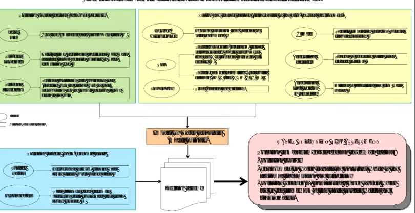
(2)Schematic overview of main factors involved in the pollution processes and risks assessment
Factors Criteria / Parameters (Inputs)
Pesticide application Pesticide properties
Half-life time, partitioning coefficient, molar mass, saturated vapour pressure, solubility in water, formulation type, …
Pesticide application date, application type (spraying onto the canopy, onto the soil, incorporation into the topsoil, injection at some depth in the soil)
Pollution source factors (anthropic pressure)
Geology/ Hydrogeology
Soil
Climate
Topography Slope (gradient and direction) Geologic substratum type, presence of karst phenomena, …
Physical properties (substratum, texture, natural drainage, profile development, type and % of stoniness, thickness, bulk density, …)
Physico-chemical parameters - soil profile database (pH, % clay, % OM, CEC, …)
Rainfall, temperature, radiation, potential evapotranspiration, …
Agricultural facilities
Presence of vegetative buffer strips, drainage systems, …
Agricultural plots location in landscape
Distance of agricultural land from water bodies, …
Land
use Crop type, emergence date, development stage, …
Vector and transit factors (vulnerability of the agro-physical environment)
Surface waters
Hydrographic network, drinking water taking places, ponds, bathing areas, …
Pollution targets (socio-economic issue)
Groundwaters
Water catchment areas, catchment prevention areas, groundwater table depth, spring, fountain, …
Decision scheme
Impact on water resources
(model outputs)
Pollution risk assessment depends on three main factors:
-
pollution source
-
environment in which transits the pollutant, which is the
vector of transmission and dispersion
-
pollutant receiver(s), constituting a given target, which
are in the framework of this study surface waters and
groundwaters.
WATER POLLUTION RISK ASSESSMENT
Fig. 1 – Generalisation of the Digital Soil Map of the Belgian Walloon region (Bah et al., 2006, FUSAGx – DGA, MRW), considered as Main Soil types of Wallonia (southern part of Belgium).
Molignée catchment (study area)