For Peer Review Only
3D hydrostratigraphical modelling of the regional aquifer system of the St. Maurice Delta Complex (St. Lawrence
Lowlands, Canada)
Journal: Canadian Water Resources Journal Manuscript ID TCWR-2016-0059.R2
Manuscript Type: Original Paper Date Submitted by the Author: 02-Apr-2017
Complete List of Authors: Légaré-Couture, Guillaume; Institut national de la recherche scientifique, Centre Eau Terre Environnement
Leblanc, Yves; Universite du Quebec a Trois-Rivieres, Environmental sciences
Parent, Michel; Commission géologique du Canada, Ressources naturelles Canada
Lacasse, Karine; Université du Québec à Trois-Rivières, Environmental sciences
Campeau, Stephane; Universite du Quebec a Trois-Rivieres, Environmental sciences
Keywords: Granular aquifers, Quaternary deposits, 3D geological modelling, High resolution seismic reflection, Champlain Sea
For Peer Review Only
3D hydrostratigraphical modelling of the regional aquifer system of the
1St. Maurice Delta Complex (St. Lawrence Lowlands, Canada)
2Guillaume Légaré-Couture1, Yves Leblanc2, Michel Parent3, Karine Lacasse2 and 3
Stéphane Campeau4 4
5
1
Institut national de la recherche scientifique, Centre Eau Terre Environnement, 6
Québec City, Québec, Canada, G1K 9A9, [email protected] 7
2
Département des sciences de l'environnement, Université du Québec à Trois-Rivières, 8
Trois-Rivières, Québec, G9A 5H7, [email protected], 9
3
Commission géologique du Canada, Ressources naturelles Canada, Québec, 11
G1K 9A9, [email protected] 12
4
Corresponding author : Département des sciences de l'environnement, Université du 13
Québec à Trois-Rivières, Trois-Rivières, Québec, G9A 5H7, 819-376-5011, 14
16
For the use of the editors
Paper #: TCWR-2016-0059.R2 Submitted on: October 14, 2016 Accepted on: April 3, 2017
Application - Research – Commentary – Book Review: Research (QC GW SI) Copyright Held by: CWRA
T2012 17
For Peer Review Only
Abstract18
In the central part of the St. Lawrence Lowlands (Mauricie, Québec), Late 19
Quaternary deglacial events led to the formation of a series of complex granular aquifers, 20
such as those in the 1) Saint-Narcisse morainic complex, 2) paleodelta formed by the 21
Saint-Maurice River, and 3) sandy littoral terraces left during marine regression. The 22
aquifers are an important supply of potable water for most municipalities in the region, 23
including the City of Trois-Rivières, which is a mid-size city where groundwater 24
accounts for 46% of the water supply. The main objectives of this study were to build a 25
3D model of the Quaternary deposits to define the main hydrogeological contexts of the 26
Mauricie region and to characterize the regional aquifers. The compilation of existing 27
hydrogeological data led to the selection of 5386 well logs that contained stratigraphic 28
information of variable quality, ranging from only surficial sediment thickness to 29
descriptions of fully cored boreholes. To supplement the existing data, fieldwork was 30
undertaken in areas where few data were available, including 63 km of high resolution 31
seismic reflection surveys and 34 new boreholes. The final 3D model consists of six 32
layers, from the bedrock surface to the upper littoral and deltaic sands. The total thickness 33
of the deposits ranges from zero, on bedrock outcrops, to 150 m beneath central Trois-34
Rivières. Taking into account the thickness of the saturated layer and the porosity of the 35
sand and gravel, the upper unconfined aquifer contains an estimated 364 million m3 of 36
water. The 3D model helped refine our understanding of regional aquifers and was used 37
to identify unexploited aquifers, notably around the Saint-Narcisse morainic complex and 38
along the St. Cuthbert Fault. The model clarified the regional stratigraphic architecture, 39
especially topography of the bedrock surface, the lateral extent of Late Quaternary sands 40
and development of Holocene post-glacial sediment sequences. 41
Keywords : Granular aquifers, Quaternary deposits, 3D geological modelling, High reso-42
lution seismic reflection, Champlain Sea 43
For Peer Review Only
Résumé44
Dans la partie centrale des Basses-Terres du Saint-Laurent (Mauricie, Québec), la 45
dernière déglaciation a mené à la formation d’aquifères granulaires complexes, tels que 46
ceux associés à la moraine de Saint-Narcisse, au paléodelta de la rivière Saint-Maurice et 47
aux terrasses littorales associées à la régression marine. Ces aquifères représentent la 48
source principale d’eau potable pour la majorité des municipalités de la région, incluant 49
Trois-Rivières, une ville de taille moyenne où les eaux souterraines contribuent à 46% de 50
l’approvisionnement. L’objectif de cette étude était de développer un model 3D des 51
dépôts quaternaires afin de définir les principaux contextes hydrogéologiques et de 52
caractériser les aquifères régionaux de la Mauricie. Le recensement des données 53
hydrogéologiques existantes a permis de compiler les résultats de 5386 puits et forages 54
contenant des informations stratigraphiques de qualité variable. Les données existantes 55
ont été complétées par de nouveaux relevés, incluant 63 km de sismique réflexion haute 56
résolution et 34 forages. Le model 3D final est constitué de sept couches, de la surface du 57
rock aux sables littoraux et deltaïques superficiels. L’épaisseur total des sédiments 58
quaternaires varie de nulle sur les affleurements rocheux à 150 m à l’ouest de la ville de 59
Trois-Rivières. Le volume total des sables superficiels, dans les limites de la ville de 60
Trois-Rivières, a été estimé à 4.7 milliards de m3. En tenant compte de l’épaisseur de la 61
zone saturée et de la porosité moyenne du sable, la nappe libre contiendrait un volume de 62
364 millions de m3 d’eau. Le model tridimensionnel a permis d’approfondir notre 63
connaissance des aquifères régionaux et d’identifier des aquifères non exploités, 64
notamment en marge de la moraine de Saint-Narcisse et le long de la faille de St-65
Cuthbert. Le model a également permis de préciser l’architecture des dépôts et la 66
stratigraphie régionale, particulièrement en ce qui concerne la topographie de la surface 67
du rock, l’extension latérale des dépôts pléistocènes et la séquence des sédiments 68
postglaciaires. 69
Introduction 70
The current landscape of the St. Lawrence Valley is mainly the result of erosion 71
and deposition during successive Late Quaternary events. Deglaciation was followed by a 72
For Peer Review Only
2000-year long incursion of an arm of the Atlantic Ocean into the St. Lawrence, known 73
as the Champlain Sea. During this marine episode, a series of coastal, deltaic and 74
offshore depositional systems developed in the valley. Following the regression of the 75
Champlain Sea and the drainage of its successor basin (Lake Lampsilis), fluvial incision, 76
sedimentation and terrace formation by the early St. Lawrence River and its tributaries 77
became the main centres for active geological processes in the valley. Elsewhere in the 78
region, this late-glacial period was characterized by the development of peatlands, 79
notably on the large flat surfaces of the St. Maurice paleodelta. 80
The last deglacial events led to the formation of a series of complex granular 81
aquifers, such as the Saint-Narcisse morainic complex, the Saint-Maurice River 82
paleodelta, and the stepped sandy terraces formed along the shores of the Champlain Sea 83
and along the St. Lawrence River and tributaries. The characteristics and distribution of 84
these aquifers are partially known through various hydrogeological studies conducted by 85
municipalities, government agencies and private consulting firms. Unfortunately, these 86
studies had limited application regionally because they were generally local in scope and 87
scale. The first regional groundwater map of the Mauricie region was constructed by 88
McCormack (1983), who noted the good aquifer potential of the surficial and near 89
surface sediments of the north shore, while the aquifer potential of fractured bedrock was 90
deemed lower. While he identified buried valleys filled with sand and gravel deposits, he 91
had not evaluated the hydrogeological potential of these confined aquifers. In the nearby 92
Lake Maskinongé area, Denis (1974) also mentioned that the bedrock formations of the 93
region had a low aquifer potential, while the granular aquifers were more important. 94
Nonetheless, and despite these preliminary attempts to map the local aquifers, there still 95
lacks comprehensive knowledge of the different hydrogeological units and their surface 96
or subsurface distribution. Given the crucial importance of groundwater as a source of 97
potable water in the region, both from quality of life and economic viewpoint, we 98
determined that a more thorough characterization and assessment of regional aquifers 99
was needed. 100
Groundwater has been exploited in the Mauricie region since the nineteenth 101
For Peer Review Only
Yamachiche, for example, an aqueduct was built in 1873 to extract spring water 103renowned for its high quality. In the early twentieth century, a brackish water source 104
located in Saint-Léon-Le-Grand became known for its healing properties. Nowadays, the 105
granular aquifers of the Mauricie region are the source of potable water for most of its 106
municipalities, including the City of Trois-Rivières, which is one of few small urban 107
centers in Canada where groundwater constitutes a large part of the drinking water supply 108
(46%). In addition, the use of geothermal energy for heating and cooling has expanded 109
during the last decade. Given the relatively high groundwater temperature (10°C in Trois-110
Rivières) and the high aquifer potential of the region, it is likely that geothermal systems 111
will continue to expand rapidly in the near future to capture thermal energy from the 112
warmer groundwater. 113
Given the lack of comprehensive knowledge about the regional aquifers and the 114
crucial role of groundwater in the Mauricie region, a regional groundwater study was 115
initiated by Université du Québec à Trois-Rivières (UQTR) researchers in collaboration 116
with governmental agencies and regional partners (including the regional council of 117
elected officials, regional municipalities, the City of Trois-Rivières and watershed 118
agencies). The study was conducted between 2009 and 2013 as part of the Groundwater 119
Knowledge Acquisition Program (PACES), sponsored by the Quebec Ministry of the 120
Environment (MDDELCC). One of the main objectives of this study was to build a 3D 121
model of Quaternary deposits to better define the hydrogeological framework for the 122
Mauricie region and characterize the aquifer properties. 123
Study area 124
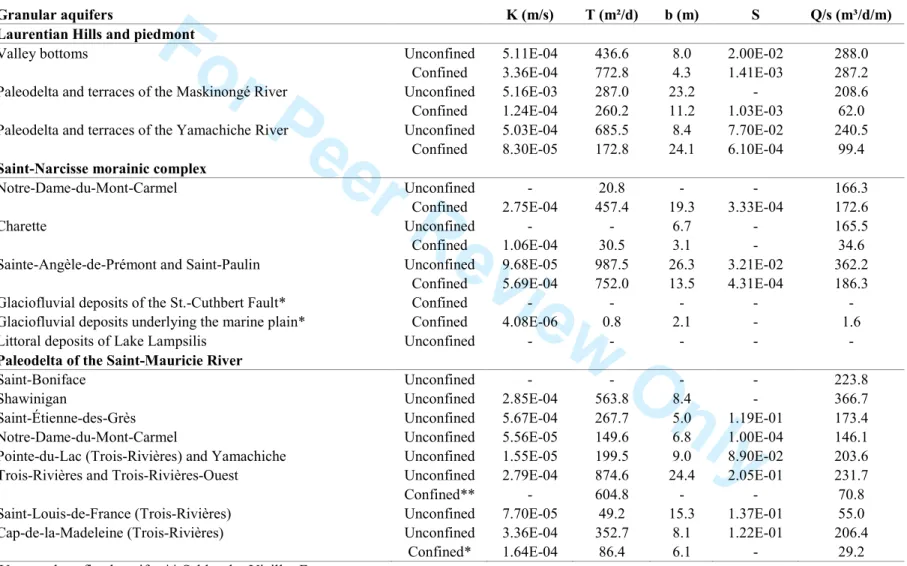
The study area (3 900 km2) is located in the southwest of the Mauricie region, between 125
Montréal and Québec (Figure 1). The total population (2011) is 223 200 inhabitants, distributed into 126
two main urban centers (Trois-Rivières and Shawinigan) and one regional municipality 127
(Maskinongé). The northern part of the study area lies in the Laurentian Hills, and is mostly 128
forested, whereas the southern part is underlain by the relative flat terrain of St. Lawrence platform 129
and is occupied by farmlands, except for the urban area of Trois-Rivières. The shield terrain of the 130
Laurentians is characterized by steep-sided knolls and knobs, intersected by linear through-valley 131
For Peer Review Only
systems, often occupied by chains of lakes and logging roads, while the St. Lawrence platform is 132
underlain by Paleozoic sedimentary rocks covered by thick Quaternary sediments, where 133
agriculture is the main economic activity. The main rivers (Maskinongé, du Loup, Yamachiche and 134
St. Maurice) flow southward from the Shield terrain to the lowlands. The hydrological regime of 135
these catchments is characterized by spring snowmelt and low flow during summer with episodic 136
storm events, typical of continental sub-humid, subpolar climates. Catchments receive between 850 137
and 1200 mm of precipitation annually, evenly distributed during the year. 138
Figure 1. Location and digital elevation model of the study area. The four main 139
regional hydrogeologic contexts are shown: the Laurentian Hills, Saint-Narcisse 140
morainic complex, Marine clay plain and paleodelta of the St. Maurice River. 141
First, a compilation map of bedrock formations was realized as part of this project, based on 142
the studies conducted by Clark et Globensky (1976), Globensky (1987) and Nadeau and Brouillette 143
(1995). The lithological composition of the Grenville Province, a major subdivision of the Canadian 144
Shield, consists mainly of igneous and metamorphic rocks, such as gneiss, orthogneiss, paragneiss, 145
migmatite and marble, along with intrusive rocks such as gabbronorite, anorthosite, monzonite and 146
monzogranite. The Grenville rocks are moderately folded in the allochthonous monocyclic belt and 147
strongly folded in the polycyclic belt. The rocks of the Morin Terrane, in the south and west of the 148
study area, were slightly deformed during the Grenville orogeny to form a large regional syncline. 149
The sedimentary rocks of the lowlands consist mainly of Ordovician sandstones, 150
limestones and shales deposited in marine environments. Sandstones and limestones (Black River 151
and Trenton groups) are exposed in isolated outcrops in the northern part of the lowlands, while the 152
shales (Utica and Lorraine groups) are buried under considerable thicknesses of Quaternary 153
sediments near the St. Lawrence River. These shales contain significant concentrations of natural 154
gas as well as oil seeps and have been fully described in geological reports (Globensky, 1987). The 155
fractured bedrock aquifers, both in the shield and the lowlands, only supply private wells. 156
Secondly, an updated map of surficial deposits was constructed (Figure 2) based on results 157
of previous studies by Denis (1974), Bolduc (1999a, b) and Lamarche (2005). The 158
Laurentian Hills are characterized by a thin till veneer with numerous rock exposures. 159
For Peer Review Only
marine sediments that commonly overlie ice-proximal sandy gravels that are buried. The 161
Saint-Narcisse Moraine lies along the southern margin of the Canadian Shield, but 162
slightly beyond in the St. Maurice River valley. The moraine was emplaced by a re-163
advance of the Laurentide Ice Sheet during the early cold phase of the Younger Dryas. In 164
stratigraphic sections in the moraine, a variety of sediment facies, including glacially 165
entrained clay and till wedges, are exposed along with proximal glaciomarine deposits, 166
melt-out till and ice-marginal outwash (Occhietti, 2007). As the Laurentide Ice Sheet 167
retreated to the north, the Champlain Sea flooded the Saint Lawrence Valley up to almost 168
200 m asl, an event that led to the deposition of a thick silt and clay cover in the deeper 169
offshore basins and littoral and sublittoral sands in shallower areas. Deltas, large and 170
small, also formed in valleys at the mouth or rivers entering the Champlain Sea. 171
Figure 2. Quaternary geology and location of the new geophysical surveys and 172
boreholes. The location of the existing boreholes and wells (5 386) used to build the 173
model are not shown. See Table 2 for a detailed description of the units. 174
The Quaternary stratigraphy of the area was described by Gadd and Karrow 175
(1959), Denis (1974), Occhietti (1980, 2007), Ferland and Occhietti (1990) and Clet and 176
Occhietti (1996). The most complete stratigraphic sections were observed along the St. 177
Maurice River. The base of the Quaternary sequence is characterized by a fluvial 178
sediment complex directly overlying bedrock. This unit is correlated with the Lotbinière 179
Sand (Hardy and Lamothe, 1997), rather than the St. Pierre Sediments as originally 180
thought by Gadd and Karrow (1959). The overlying unit, containing a nine meter-thick 181
varve series, is known as the St. Maurice Rhythmites since it corresponds to a lacustrine 182
environment younger than that of the Deschaillons Varves (Besré and Occhietti, 1990). 183
The rhythmites are overlain in the regional stratigraphic record by the stratified Vieilles-184
Forges Sands, with three lithozones (lacustrine, deltaic and proglacial). This sequence is 185
capped by the Gentilly Till, which is in turn overlain by the usual postglacial sequence 186
containing glaciofluvial sediments, Champlain Sea sediments, Lake Lampsilis sediments, 187
and alluvial and organic sediments (Table 2). 188
For Peer Review Only
Methods189
Compilation of existing boring data
190
Existing hydrogeological data were compiled from the sources presented in Table 191
1. All the municipalities in the study area were visited to obtain existing hydrogeological 192
studies. The databases from the major water supply providers were integrated, including 193
those from the cities of Trois-Rivières and Shawinigan and from a regional water supply 194
network (Régie d’Aqueduc de Grand-Pré). The compilation of existing hydrogeological 195
data led to the selection of 5386 logs for the modelling that contained some stratigraphic 196
information. Among these entries, 2185 reached bedrock and 3201 ended within 197
Quaternary sediments. The reliability of the existing data was evaluated based on the 198
criteria proposed by Ross et al. (2005) and Chesnaux et al. (2011), and hydrostratigraphic 199
codes were assigned to each entry in the database. When available, the hydraulic 200
properties were integrated to the database. 201
Field work
202
To supplement the existing data, fieldwork was undertaken in areas where data were 203
sparse or the stratigraphic interpretations were uncertain (Figure 2). The new fieldwork 204
included: 205
• 75 electrical resistivity surveys (using a TX-II transmitter and PP GRX-832 206
receiver). The interpretations were validated with borehole logs located within 207
500 m of the survey line; 208
• 50 seismic refraction surveys (using a Smartseis ST with 24 geophones); 209
• 63 km of high resolution seismic reflection surveys (using the Minivibe); 210
• 11 cone penetration tests (using a Geotech 605D); 211
• 23 boreholes were drilled by different techniques (rotation, percussion, pionjar 212
and rotasonic). Monitoring wells were installed in most of the boreholes. The 213
sediments were sampled at regular intervals or at the transition between two 214
stratigraphic units. Particle size analysis (Analysette 22 MicroTec) was carried 215
For Peer Review Only
from the grain size analysis. Radiometric dating (Beta Analytic Inc) was 217conducted on three samples of shells or organic material. Water level 218
measurements and pumping tests were carried out in most wells. 219
Finally, the detailed Quaternary geology mapping was carried out throughout the 220
region, but more specifically in areas along the boundary of maps created by different 221
authors. The data collected in the field allowed us to produce a relatively uniform 222
compilation map of surficial sediments for the study area. 223
Geostatistical modelling approach
224
Cokriging was used to create gridded surfaces connecting the logs according to 225
the elevation of stratigraphic contacts. This method of geostatistical estimation considers 226
the spatial covariance and assigns a different weight to the observations based on their 227
reliability. A digital elevation model (DEM) was used to determine the elevation of all 228
borehole sites included in the database. The model also considered the outcrops of all 229
deposits and the known stratigraphy shown on geological sections. Additionally, some 230
adjustment points were manually added to the model at locations where available data 231
were either insufficient or inadequate. For example, the range of the variogram was 232
sometimes insufficient to properly interpolate grid values up to the boundaries of the 233
study area and some adjustment points were added to fill in the void. The adjustment 234
point were not included in the calculation of the error for each layer. Virtual sections 235
were also generated using Hydro GeoAnalyst software to link, at the regional scale, 236
similar facies where data are sparse or widely spaced (Ross et al. 2005). A final 237
validation was performed to check whether the model-generated layers were contained in 238
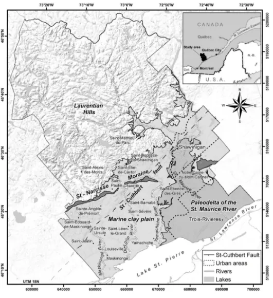
the volume between the rock surface and the ground surface. Figure 3 shows the 239
flowchart of the GIS operations used to model the top surface of each hydrogeological 240
unit. 241
Figure 3. Flowchart of the GIS operations used to model the top surface of each 242
hydrogeological unit. 243
For Peer Review Only
Results244
Three-dimensional mapping of Quaternary deposits
245
The model consists of seven layers representing the topography of the bedrock 246
surface and the main hydrogeological units encountered in the study area. Because the 247
model is being constructed at a regional scale, some units were merged with other in 248
order to give precedence to the more extensive and thicker aquifers and aquitards. 249
Topography of the bedrock 250
A total of 1584 observations from boreholes and geophysical data were used to 251
model the surface of the bedrock. Before the addition of adjustment points, the root mean 252
squared error between the observed and predicted values was 5.0 m. In addition, 484 253
bedrock outcrop areas were used as control to model the bedrock surface. 254
In the lowlands, near the St. Lawrence River, the smooth bedrock surface lies as 255
much as 100 m below present sea level. However, the bedrock surface rises to the north-256
east of the St. Maurice River and on the south shore of the St. Lawrence River. On a 257
south-north axis, the bedrock surface rises slowly northwestward toward the Piedmont, 258
except along the St. Cuthbert Fault, which is the locus of a NE-trending linear depression 259
in bedrock. The maximum elevation of 540 masl is reached in the Laurentian Hills, north 260
of the municipality of Saint-Alexis-des-Monts. 261
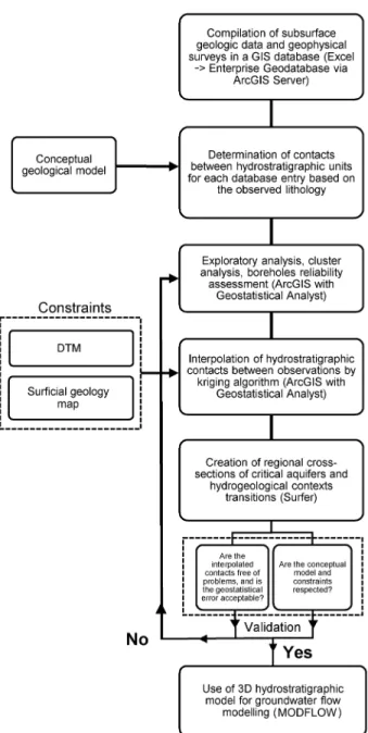
Figure 4 shows the total thickness of Quaternary deposits. This map was produced 262
by subtracting the elevation of the DEM surface from the elevation of the bedrock 263
surface. The thickest deposits reach 150 m in the western part of the City of Trois-264
Rivières where the bedrock surface lies at -80 m, an elevation which is quite similar to 265
that underneath Yamachiche and which is amongst the lowest of the entire central St. 266
Lawrence Lowlands (Prévôt, 1972). 267
Figure 4. Total thickness of Quaternary deposits. The thickest deposits, reaching 268
150 m, are in the western part of the City of Trois-Rivières. 269
For Peer Review Only
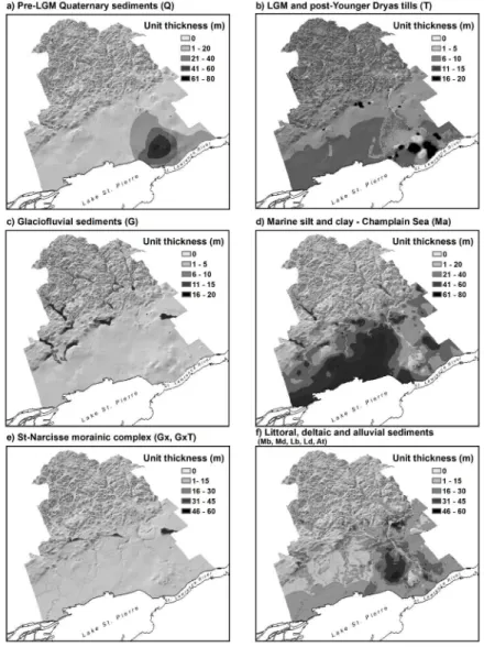
Pre-LGM Quaternary sediments270
Pleistocene sediments deposited prior to the Last Glacial Maximum (LGM) have 271
been observed in sections bordering the St. Maurice River and were also intersected by 272
drilling in the southeast part of the study area. A total of 85 observations from boreholes 273
and geophysical data were used to model the upper contact of pre-LGM sediments 274
(Figures 5a and 6a). Before the addition of adjustment points, the root mean squared error 275
between the observed and predicted values was 8.6 m. In addition, 3 surficial outcrops 276
were used to control the modeled surface. Reliable drilling logs containing descriptions 277
of the unit were only found around the City of Trois-Rivières, where the maximum 278
thickness of the unit is 80 m. However, it is possible that other remnants of pre-LGM 279
Quaternary sediments are preserved elsewhere in the region. Given their rare occurrence 280
in drilling record, no attempt was made to model separately the different pre-LGM 281
sediment subunits in the 3D hydrostratigraphical model. However, some pre-LGM 282
subunits could be identified in high resolution seismic profiles. These deposits are 283
discontinuous and their thickness varies depending on the topography of the bedrock 284
surface. 285
Figure 5. 3D model of Quaternary deposits. The model consists of six layers 286
representing the main hydrogeological units observed above bedrock in the study 287
area. The six layers represent the Pleistocene sediments (pre-LGM) (a), LGM and 288
post-Younger Dryas tills (b), glaciofluvial sediments (c), marine silt and clay (d), St. 289
Narcisse morainic complex (e) and littoral, deltaic and alluvial sediments (f). 290
291
Figure 6. Thickness grids (m) of Quaternary deposits. 292
LGM and post-Younger Dryas tills 293
Gentilly Till is the regional surficial diamicton (till) deposited during the 294
Wisconsinan glaciation. In the context of this paper, it includes diamictons that were 295
deposited during and after the St-Narcisse Moraine episode. Gentilly Till is a sandy-silt 296
For Peer Review Only
diamicton having a Precambrian crystalline rock content ranging from 100% in the Shield 297
terrains to less than 10% on the Paleozoic platform. A total of 162 observations from 298
boreholes and geophysical data were used to model the upper contact of Gentilly Till 299
(Figures 5b and 6b). Before the addition of adjustment points, the root mean squared 300
error between the observed and predicted values was 3.6 m. In addition, 241 surficial 301
polygons were used to model the surface of the unit. 302
In the Laurentians, the glacial till cover is discontinuous and its thickness varies 303
from 0.1 m to 2 m. However, the till can be 6 m thick where mapped as continuous cover. 304
Along the St-Narcisse Moraine, the till thickness varies between 1 m and 50 m. In 305
drilling records around the moraine, till wedges (thrust slices in most cases) deposited by 306
the advancing ice sheet are difficult to differentiate from glaciofluvial sediment bodies 307
emplaced subsequently and commonly reworked by littoral Champlain Sea processes. 308
South of the moraine, in the clay plain, the till usually takes the form of a veneer varying 309
in thickness depending on the topography of the bedrock surface. 310
Glaciofluvial sediments 311
Sediments carried by glacial meltwater were deposited in the deep valleys of the 312
Canadian Shield and in bedrock depressions along the St. Cuthbert Fault. In the northern 313
part of the study area, at elevations above 200 m asl, these sediments are well exposed at 314
the surface, while in very deep valleys and on the Shield margins, they are almost 315
continually covered with fine-grained sediments of marine or lacustrine origin. A total of 316
341 observations from boreholes and geophysical data were used to model the upper 317
contact of glaciofluvial sediments (Figures 5c and 6c). Before the addition of adjustment 318
points, the root mean squared error between the observed and predicted values was 2.6 m. 319
In addition, 117 sediment surface polygons were used to control the modeled surface. 320
The largest thicknesses were observed under the deep valleys of the Canadian Shield, 321
under the St-Narcisse Moraine and along the St. Cuthbert Fault. 322
Marine silt and clay 323
For Peer Review Only
As the St. Lawrence valley had been isostatically depressed by the Laurentide Ice 324
Sheet, an arm of the Atlantic Ocean, known as the Champlain Sea, inundated the valleys 325
up to elevations equivalent to 200 m asl (Parent et Occhietti, 1988, 1999). The marine 326
transgression lasted about 2500 years (between 13 cal ka BP to 10.5 cal ka BP), and the 327
incursion was characterized by the deposition of thick, sparsely fossiliferous marine 328
clays. Around 9.8 ka BP, marine waters gradually drained due to the isostatic rebound 329
and saltwater was replaced by freshwater (Lake Lampsilis). With continued isostatic 330
adjustment, as well as reduced meltwater influx to the basin, Lake Lampsilis was 331
gradually drained by the Proto St. Lawrence River (7.5 cal ka BP to 3.0 cal ka BP). 332
A total of 2287 observations from boreholes and geophysical data were used to 333
model the upper contact of marine and lacustrine sediments (Figures 5d and 6d). Before 334
the addition of adjustment points, the root mean squared error between the observed and 335
predicted values was 5.1 m. In addition, 118 sediment surficial outcrops were used to 336
control the modeled surface. Marine and lacustrine sediments overlie till and glaciofluvial 337
sediments in the major valleys of the Canadian Shield, as well as most of the St. 338
Lawrence Lowlands. The thickest units of fine-grained sediments are located around the 339
municipalities of Yamachiche and Louiseville, where more than 80 m of silt and clay are 340
recorded in the drilling records. These maximum thicknesses are controlled by a 341
depression in the bedrock around Lake St. Pierre (Prévôt, 1972). In the paleodelta of the 342
St. Maurice River, the thickness of subsurface silty clay sediments varies from 0 to 30 m. 343
St. Narcisse morainic complex 344
The Saint-Narcisse morainic complex was emplaced during a re-advance of the 345
Laurentide Ice Sheet from 12.9 to 12.5 cal ka BP, along the southern margin of the 346
Laurentians where it forms a 750 km long crest (Occhietti, 2007). From west to east, the 347
moraine successively covers the Precambrian bedrock and then fine-grained Champlain 348
Sea sediments in the St. Maurice valley. The moraine forms prominent ridges near 349
Charette and Mont-Carmel. The moraine is composed of reworked clay and till, proximal 350
glaciomarine deposits and melt-out till and ice-marginal outwash (Occhietti, 2007). 351
For Peer Review Only
A total of 75 observations from boreholes and geophysical data were used to 352
model the upper contact of the St. Narcisse morainic sediments (Figures 5e and 6e). 353
Before the addition of adjustment points, the root mean squared error between the 354
observed and predicted values was 7.5 m. In addition, 41 sediment outcrop polygons 355
were used to control the modeled surface. In the Lower Mauricie region, the composition 356
of the morainic complex varies widely, but generally it consists of gravel, coarse sand 357
and poorly sorted medium sands deposited above a layer of marine sediments. The 358
thickness of this layer of coarse sediments varies from 10 to 50 m. 359
Littoral, deltaic and alluvial sediments 360
During the Holocene, the retreat of the ice sheet was accompanied by regional 361
isostatic uplift estimated at 9 m/100 years (Lamarche, 2005). The Champlain Sea was 362
replaced by Lake Lampsilis, a freshwater successor basin that lasted about 1500 years. 363
The present drainage system was gradually emplaced, thus creating successive terrace 364
levels as base levels fell. The modeled layer that represents the surface sands includes (1) 365
all sand units overlying fine-grained Champlain Sea sediments, including coastal and 366
deltaic silty sands, (2) lacustrine sands and silts of Lake Lampsilis, and (3) marine and 367
lacustrine deltaic sands of the St. Maurice River (Figures 5f and 6f). 368
The upper sands are exposed at the land surface and therefore was not modeled 369
separately. The unit covers a total area of 1078 km2. The thickest areas of the surface 370
sand aquifer are located in the western and eastern sectors of the City of Trois-Rivières, 371
as well as in the localities of Sainte-Angèle-de-Prémont, Saint-Élie-de-Caxton and 372
Charette. In the Trois-Rivières area, the total volume of the upper aquifer is estimated at 373
4.7 billion m3, 31% of which is saturated according to our subsurface records. The unit 374
has an estimated porosity of 25%, this means that about 364 million m3 of water are 375
contained in the unconfined aquifer. The aquifer has an average hydraulic conductivity of 376
6x10⁻⁴ m/s. Groundwater generally flows toward southeast, its level ranging from 60 m 377
upstream to 6 m at the outlet. Champlain Sea clays form the floor of the upper aquifer, 378
preventing groundwater from seeping further down through the Quaternary sequence. 379
For Peer Review Only
This aquifer is the most extensively exploited in the region and supplies drinking water to 380
about half of the population of the City of Trois-Rivières. 381
Regional hydrogeologic contexts
382
Based on the 3D model, the four main regional hydrogeologic contexts of the 383
study area were determined from the physiographic, geological and hydrogeological 384
features (Figure 1). The hydraulic properties of the aquifers pertaining to each context are 385
presented in Tables 3 and 4. 386
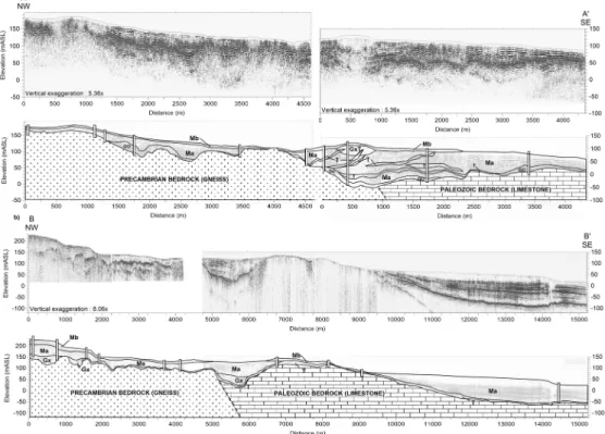
Laurentian Hills 387
This hydrogeological context consists of fractured bedrock aquifers with low 388
productivity (Table 4) along with granular aquifers within glaciofluvial deposits filling 389
deep valleys. Up to an elevation of 200 masl, these deposits were covered by marine silts 390
during the Champlain Sea marine transgression. Electrical resistivity surveys revealed 391
over 60 m of silty clay in the Rivière-du-Loup Valley. Similar contexts were also 392
encountered in the valleys of the Maskinongé, Yamachiche and Shawinigan rivers. 393
Elsewhere in the Laurentian Hills, deltaic sands and gravels were deposited by 394
meltwaters at the mouths of major valleys entering the Champlain Sea. The glaciofluvial 395
and deltaic deposits were reworked by waves and currents forming the high and low 396
terraces along the piedmont. The aquifers found in these deposits are the main source of 397
potable water for most municipalities in the area. 398
The geologic log for borehole FE-04-11 (Figure 7), located in the village of Saint-399
Élie-de-Caxton, illustrates this typical hydrostratigraphic complex. Directly overlying 400
granitic gneiss bedrock, at depth of 65.5 m, Champlain Sea sediments from 109 m asl to 401
140 m asl consist of ice-proximal sandy facies grading upward into a distal clay facies at 402
134 m asl. The top layer consists of fine prodeltaic sands. 403
Saint-Narcisse morainic complex and Laurentian foothills 404
The morainic complex frequently forms double aquifers with an unconfined 405
aquifer within the surface sands, and a confined aquifer in the glaciofluvial sediments 406
For Peer Review Only
underlying a clay or till aquitard resting on bedrock. These aquifers are relatively small 407
and hydraulically isolated from each other. Several electric resistivity surveys indicated 408
an overall thickness of over 60 m. Borehole FE-09-11 is representative of this 409
hydrostratigraphic setting (Figure 7). The bedrock (garnet gneiss) was reached at a depth 410
of 87 m. Overlying bedrock is a glaciofluvial unit consisting of sands (fine, medium and 411
coarse) and gravel, which is overlain by the Champlain Sea clays and silts from a depth 412
of 44 to 67 m. The overlying units include a coarsening upward sequence of silty fine sand to 413
gravelly sand with a high hydraulic conductivity associated with the Saint-Narcisse readvance. 414
Figure 7. Logs of selected boreholes with lithology and grain size. The locations of 415
the boreholes are shown in Figure 2. 416
The L1-2011 Minivibe line was run perpendicularly across the morainic complex 417
(Figure 8a). The line begins over Precambrian bedrock in the north, which is buried by 418
marine clays and thin beach sands. It passes over a narrow bedrock valley before crossing 419
the moraine (GxT) and entering the marine clay plain. The moraine is locally covered by 420
a thin layer of sand, and overlies heterogeneous glaciofluvial deposits. The glaciofluvial 421
sands and gravels rest on glaciotectonized clay and till wedges emplaced by the 422
advancing glacier. 423
Although the hydrostratigraphy of the moraine is complex, it contains an 424
important regional aquifer, as most of the small municipalities located along the moraine 425
and in the adjacent marine clay plain draw their drinking water from it. Moreover, the 426
moraine acts as a recharge area for the sandy surface aquifers connected to it. New 427
boreholes and geophysical surveys completed for this project revealed the presence of 428
double aquifers along the moraine that have yet been unexploited for a municipal water 429
supply. 430
Marine clay plain 431
The fine-grained sediments of the Champlain Sea sequences represent a regional 432
aquitard that confines the underlying aquifer unit containing groundwater with high 433
For Peer Review Only
The municipalities of this area rely on a regional water supply network (Régie d’Aqueduc 435
de Grand Pré) whose wells are located near the foothills of the Laurentian Hills. 436
However, there are also a few private wells drawing water from the sandstone and 437
limestone bedrock. 438
The L7-9-2010 Minivibe lines (Figure 8b) are representative of the clay plain. In 439
the south part, surficial sediments consist mainly of silt and clay ranging in thickness 440
from 60-70 m, gradually decreasing further north. The underlying till becomes a thin 441
veneer over a partly buried rock ridge between kilometres 6 and 8.5. The bedrock surface 442
then plunges abruptly to form a depression two kilometres wide and 80 metres deep. The 443
buried depression appears to be filled with about 20 metres of gravel and sand. The 444
depression is covered by fine-grained marine sediments. This unit could potentially hold 445
significant quantities of groundwater. The axis of these deposits lie directly over the St. 446
Cuthbert Fault, which is a regional structure marking the boundary between Precambrian 447
Shield and sedimentary rocks of the Lowlands. It is possible that similar sand and gravel 448
aquifers are present elsewhere along the fault. 449
Figure 8. High resolution seismic survey lines L1-2011 (a) and L7-9-2010 (b). The 450
profile interpretations are shown below the seismic profiles. See Figure 2 for 451
location of the seismic lines and Table 2 for a detailed description of the units. 452
Paleodelta of the St. Maurice River 453
The paleodelta of the St. Maurice River is the largest aquifer in the region. The 454
delta forms a wide sand-dominated fan over a thin layer of silty marine sediments on the 455
east side of the river, and over a thick layer of pre-LGM deposits on the west side. Over 456
the northern part of the delta, the unconfined surficial aquifer is thin and is less 457
productive and not exploited, except for erosion channels where the sediment is thicker 458
and the sands better sorted. The surficial aquifer has a much greater thickness in the 459
southern part of the delta. Borehole FE-16-12 (Figure 7) contains almost 40 m of sand of 460
varying grain sizes. A wood sample found at 29.8 m depth in the upper delta surface was 461
dated at 8 920 ± 50 BP (10.05 cal ka BP; Beta-318526). This date provides an age for the 462
beginning of the construction of the St-Maurice delta in the Champlain Sea. 463
For Peer Review Only
The aquifer is one source of drinking water for the greater Trois-Rivières area. A 464
confined aquifer is also present below the marine clays, in pre-LGM sands (Vieilles-465
Forges). However, data characterizing the aquifer are scarce. It is seldom as a water 466
source because the quality of groundwater is poor. 467
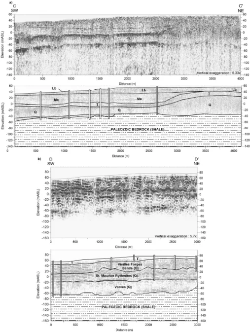
The L3-2010 and L3-2011 seismic lines were run parallel to the axis of the St. 468
Lawrence River (Figure 9). These profiles illustrate the transition from the deep water 469
depositional environment of the clay plain and the complex geology of the delta, 470
including the Lake Lampsilis sands, pre-LGM sediments and Gentilly Till. To the west of 471
the delta, the bedrock topography shows little variation, with a mean elevation of about -472
50 m below sea level. The fine-grained sediments of the Champlain Sea fill the basin to a 473
thickness of 80 m. The recent alluvial deposits of Lake Saint-Pierre cover the sequence 474
with 10 m of fine sands and silts. The light reflector observed in the marine sequence 475
could correspond to the Yamachiche Diamicton (Occhietti, 1980), which is a thin, 476
discontinuous coarse-grained deposit associated with the Saint-Narcisse Episode. The 477
sequence below the clay unit includes the Gentilly Till, Vieilles-Forges Sand, St. Maurice 478
Rythmites, Deschaillons Varves, and Lotbinière Sand. Only the first three units could be 479
differentiated from the drilling logs. 480
On the L3-2010 Minivibe line (Figure 9a), the till thickness varies from 4 m at the 481
beginning of the section, to over 20 m at kilometer 1.4, where the Lotbinière Sand begins 482
to thin out. Champlain Sea silt and clay completely wedge out at km 2.8, where the sand 483
of the Champlain Sea-Lake Lampsilis succession rest directly on the till which rises to 484
shallow depths above the LGM sediments. At this location, drilling indicates that pre-485
LGM sediments constitute the largest part of the Quaternary column (over 80 m). 486
The L3-2011 Minivibe line (Figure 9b) is the continuity of the preceding 487
sequence, about 1 km further south. The Champlain-Lampsilis sands are no longer 488
present and till is observed at the surface all along the 3 km long profile. The available 489
drilling logs allowed us to differentiate the Vieilles Forges Sand and the Saint-Maurice 490
Rythmites from the deeper and older Pleistocene sediments. 491
For Peer Review Only
Figure 9. High resolution seismic survey lines L3-2010 (a) and L3-2011 (b). The 492
profile interpretations are shown below the seismic profiles. See Figure 2 for 493
location of the seismic lines and Table 2 for a detailed description of the units. 494
To the east of the delta, a series of deltaic, lacustrine and alluvial sands form a 495
vast aquifer with a thickness ranging from 11 to 35 m. The aquifer overlies an 496
impermeable clay (aquitard unit) with an average slope of the top surface coincident with 497
the topography of the land surface (towards the SE). The aquifer is complex with 498
significant vertical heterogeneity, containing interstratified medium to silty sand layers. 499
The Quaternary deposits encountered in the borehole FE-02-11 (Figure 7) are 56.4 m 500
thick and rest on the Ordovician sedimentary platform. Gentilly Till, identified at 38 m 501
depth (-22 m below sea level), overlies a sequence of undifferentiated Pleistocene 502
sediments that is 8 m thick. Champlain Sea clay overlies the till between 18 to 37 m 503
depth. The uppermost unit, from 0 to 18.3 m, consist of alluvial, littoral and deltaic 504
sediments that were reworked by the fluctuating water levels of the St. Lawrence River. 505
The base of this unit has been dated at 7.4 ka BP (8.2 cal ka BP; Beta-318525) on the 506
basis of a wood fragment recovered at a depth of 14.5 m. Since the alluvial unit from 507
which the wood fragment was recovered marks the return to present-day conditions in the 508
St. Lawrence River, Beta-31526 provides a maximum age for the end of delta 509
construction. Taken together, the two 14C dates indicated that the main part of the St-510
Maurice delta was constructed in about 1800 years, between 10.05 and 8.2 cal ka BP. 511
Hydrostratigraphic units
512
The three-dimensional hydrostratigraphical model allowed the identification of four 513
main hydrostratigraphic units with a regional distribution: 514
• Unit 1: An aquifer within fractured bedrock, divided into three sub-units: 1) 515
aquifer in crystalline rocks (with low fracture density) of the Precambrian 516
basement; 2) aquifer in brittle sedimentary rocks (sandstones and limestones); and 517
3) aquifer in ductile sedimentary rocks (shales). This unit, while it has a regional 518
extension, has a low potential for a water supply and is not being tapped by 519
municipalities. 520
For Peer Review Only
• Unit 2: An aquifer in glaciofluvial and glacial sediments. This unit generally lies 521
immediately above bedrock. The aquifers in glaciofluvial sediments, despite their 522
small size and discontinuous areal distribution, supply a number of municipal 523
wells. Till deposits, for their part, are thin and have a low permeability. However, 524
water yields are generally sufficient to supply domestic wells. 525
• Unit 3: The regional discontinuous aquitard formed by fine-grained Champlain 526
Sea sediments. The deposits overlie almost continuously older Quaternary units in 527
the St. Lawrence Lowlands as well as in some isolated valleys or depressions of 528
the Laurentian Hills. 529
• Unit 4: An aquifer formed in the uppermost sandy sediments. The unit can be 530
divided into two sub-units: 1) sand and gravel deposits within the Saint-Narcisse 531
morainic complex; and 2) surficial sand deposits overlying fine-grained sediments 532
of the Champlain Sea, including coastal and deltaic silty sands, sands and silts of 533
Lake Lampsilis and marine and lacustrine deltaic sands emplaced by the Saint-534
Maurice River. 535
Integrating the 3D model, architecture of the hydrostratigraphic units and regional 536
distribution of hydrogeological conditions lead us to define six aquifer types shown in 537
Figure 10: 538
• Type 1: Unconfined fractured bedrock aquifers, which may be locally overlain by 539
a thin layer of till; 540
• Type 2: Confined or semi-confined fractured bedrock aquifers overlain by marine 541
silt and clay (aquitard); 542
• Type 3: Unconfined aquifers in glaciofluvial sediments or littoral sands that lie 543
directly on the bedrock; 544
• Type 4: Double aquifers consisting of an upper, unconfined sandy aquifer and a 545
confined or semi-confined aquifer in the fractured bedrock. These aquifers are 546
separated by the regional aquitard; 547
• Type 5: Additional confined aquifers in glaciofluvial sediments that lie directly on 548
the bedrock and are overlain by marine silt and clay (aquitard). These units may 549
For Peer Review Only
Figure 10. Aquifer types of the Mauricie region based on the architecture of the 551
hydrostratigraphic units. 552
Figure 10 shows the distribution of the above aquifer types. Type 1 is the most 553
common aquifer in the Laurentian Hills, except in the valleys where types 2-5 are found, 554
such as the Saint-Alexis-des-Monts aquifer in the du Loup River valley. In the piedmont, 555
the Saint-Narcisse Moraine frequently contains types 4 and 5 aquifers, all hydraulically 556
separated from each other. The paleodelta of the St. Maurice River is an unconfined 557
aquifer of regional extent and has attributes of types 4 and 5. Only the upper, unconfined 558
aquifer is exploited due to the poor quality of the groundwater in the confined aquifer 559
below, caused notably by the generalized presence of brackish water and the occasional 560
occurrence of methane. The upper aquifer supplies several municipalities including the 561
City of Trois-Rivières. Finally, along the north shore of Lake St-Pierre, the most common 562
aquifer is type 2. The marine clay plain is considered an aquitard that confines aquifers 563
(glacial till and/or the Ordovician rocks) that are heavily mineralized or contain natural 564
gas accumulations. 565
Several local conceptual models prepared during the study are summarized in a 566
cross-section shown in Figure 11 that illustrates the typical geologic and 567
hydrostratigraphic units observed in southwest Mauricie. The upper panel is a geological 568
cross-section showing the distribution of Quaternary deposits and bedrock, and is based 569
on the 3D model. The lower panel displays a profile along the same section that identifies 570
the major hydrostratigraphic units and groundwater flow lines from the conceptual 571
hydrogeological model. The trace of cross-section A-A’ is shown as a dashed line on 572
Figure 10. It starts in the Rivière du Loup valley near St-Alexis-des-Monts in the 573
northwest and runs eastward across the Saint-Narcisse Moraine near Charette, and 574
crosses Trois-Rivières towards the southeast. This profile was selected to reflect the main 575
hydrogeological contexts recognized in the region. While the elevation of the bedrock 576
surface and the terrain are both accurately depicted in the cross-section, some geological 577
and hydrogeological elements have been simplified to represent typical subsurface 578
characteristics in the study area. In other words, while the units and conditions illustrated 579
For Peer Review Only
on this cross-section are factual, they do not necessarily occur at the location of the 580
section. 581
The northwest segment of the cross-section shows typical hydrogeological 582
conditions in the Laurentian Hills. The surficial sediment cover is generally thin, and 583
valleys formed along bedrock depressions are commonly floored by coarse permeable 584
sediments that are locally overlain by fine-grained marine/estuarine sediments. Confined 585
aquifers are locally present below the Champlain Sea sediments in valleys lying at the 586
maximum marine limit. The Precambrian bedrock underlying the surficial sediment cover 587
includes igneous/metamorphic rocks with no primary porosity and very low fracture 588
porosity. It is considered as an aquifer since water flows through it, but the capacity of 589
the unit to yield an appreciable amount of groundwater ultimately depends on the 590
interconnections of the fracture network, which tends to increase near the fault zones. In 591
the northern part of the region, wells in bedrock commonly yield sufficient amounts of 592
water for domestic supply, but sometimes have to be drilled to depths exceeding 40 593
metres. 594
Figure 11. Cross-section illustrating the typical geologic and hydrostratigraphic 595
units encountered in southwest Mauricie. The trace of cross-section A-A’ is shown 596
as a dashed line on Figure 10. 597
Along the edge of the Laurentian Hills, the St-Narcisse morainic complex has 598
hydrogeological conditions conducive for groundwater extraction. The moraine and 599
associated glaciofluvial deposits on both its proximal and distal boundaries contain a 600
group of aquifers that generally are poorly connected, but nonetheless connected through 601
low-permeability glacial sediments or bedrock. The municipalities of Notre-Dame-du-602
Mont-Carmel and St-Paulin both extract groundwater from this unit. The Charette 603
segment of the morainic complex has a similar hydrogeological potential, with an 604
unconfined upper aquifer and a confined lower aquifer, both of which are not utilized. A 605
series of depressions above the St-Cuthbert fault are filled by sand and gravel that may 606
contain productive aquifers bounded by the marine clay aquitard. These depressions have 607
For Peer Review Only
hydrogeological potential of the St-Cuthbert fault area remains untested, it likely plays a 609
key role in the regional flow system by intercepting groundwater flowing from the 610
Precambrian Hills and redirecting groundwater into glacial sand and gravel aquifers in 611
the adjacent Piedmont. 612
In the clay plain, the sediment cover is very thick but is almost exclusively 613
composed of very fine-grained marine mud (silty clay) with very low permeability. The 614
underlying till unit is more permeable than the Paleozoic bedrock by an order of 615
magnitude, but is still not considered an aquifer. Groundwater within the sedimentary 616
rocks below the Quaternary deposits is generally brackish. Because the rivers flowing 617
across the plain tend to be deeply entrenched, the extent of alluvial aquifers is limited. 618
However, the paleo-deltas of the Maskinongé and Yamachiche rivers are large enough to 619
contain significant groundwater supplies, and are used for a potable water supply by the 620
towns of St-Édouard-de-Maskinongé, Ste-Ursule, St-Alexis-des-Monts, St-Élie-de-621
Caxton, Charette and St-Mathieu-du-Parc. Municipalities that are too far from the deltas 622
are supplied by a private aqueduct network operated by the Régie d'Aqueduc de Grand-623
Pré, which pumps water from wells in glacial sand and gravel aquifers near St-Boniface. 624
The cross-section ends in the St-Maurice River paleo-delta sandy aquifers (Figure 625
11). This large deltaic system was built at the mouth of the valley during regression of the 626
Champlain Sea and subsequent Lake Lampsilis. The delta overlies either marine clays or 627
older Quaternary deposits. At St-Boniface and St-Étienne (upstream on the left bank), the 628
deltaic deposits contain an unconfined aquifer which caps the stratigraphic sequence, but 629
is too thin to supply large volumes of groundwater. In some areas though, where thicker 630
well-sorted sands occur, commonly in narrow erosional channels cut in the underlying 631
clay, there may be sufficient water supply for municipalities. In the Trois-Rivières 632
(downstream right bank) and Cap-de-la-Madeleine (downstream left bank) sectors, 633
significant thickening of the surficial sand cover makes the aquifer much more 634
productive. The St-Maurice River is deeply entrenched into its former delta, cutting 635
through even the upper till layer and pre-LGM Quaternary units. This creates 636
groundwater resurgences along the river. The City of Trois-Rivières pumps water from 637
the surficial sand deposits on both sides of the St-Maurice. The sedimentary rocks 638
For Peer Review Only
underlying the Quaternary deposits are moderately permeable, but the water contained in 639
the shale unit is mineralized and only used in a few geothermal applications. 640
Discussion and conclusion 641
3D model
642
As a result of its complex Quaternary history, the Mauricie region contains 643
significant granular aquifers, such as the paleodelta of the St. Maurice and Yamachiche 644
rivers, the Saint-Narcisse morainic complex and the high sandy terraces formed during 645
Champlain Sea regression. These aquifers had been partially investigated through local 646
hydrogeological studies conducted by municipalities. New fieldwork was undertaken to 647
supplement existing data and to build a coherent hydrostratigraphical model presenting 648
the stratigraphy and architecture of surficial deposits. Taking into account the reliability 649
ratings, surfaces representing the upper and lower contacts of geological formations were 650
modeled by cokriging. The result is a 3D model with seven layers representing the 651
surficial deposits of the Mauricie region, from the surface of the bedrock to the upper 652
littoral and deltaic sands. The total thickness of the sediments varies from zero, on rock 653
outcrops, to 150 m under the City of Trois-Rivières. 654
The 3D hydrostratigraphical model has helped refine our understanding of 655
regional aquifers, particularly the thickness, distribution and sequence of surficial 656
deposits in the valleys, along the St. Cuthbert Fault, under the Saint-Narcisse morainic 657
complex and in the paleodelta of the Saint-Maurice River. New, unexploited aquifers 658
have been identified north of the City of Trois-Rivières, around the Saint-Narcisse 659
morainic complex and along the St. Cuthbert Fault. The deposits of the St. Cuthbert Fault 660
are confined aquifers resulting from the deposition of granular sediments into a series of 661
bedrock depressions observed along the axis of the fault. These aquifers, as well as 662
confined aquifers beneath the marine clay plain, are only known indirectly through the 663
interpretation of geophysical surveys, such as seismic reflection profiling. Additional 664
drilling is required to determine the grain size distributions of the deposits to assess 665
aquifer potential. 666
For Peer Review Only
Regional stratigraphy
667
The results of the 3D model is consistent with the regional stratigraphy proposed 668
by Gadd and Karrow (1959), Denis (1972), and Occhietti (1982). However, the 669
modelling helped to further clarify the regional hydrostratigraphic framework, notably 670
the topography of the bedrock surface, the subsurface extent of pre-LGM Quaternary 671
sands, and the architecture of post-Champlain Sea deposits. 672
The pre-LGM Vieilles Forges sands were identified under the marine clay layer in 673
borehole FE-02-11. This is the first drillhole that records the presence of this unit east of 674
the St. Maurice River, and this allows us to better assess the extent of this regional unit. It 675
is possible that some wells of the City of Trois-Rivières draw their water from this 676
formation, rather than from the post-Champlain upper sands. Additional drilling (with 677
dating) would be necessary to validate the extension of pre-LGM deposits north of Trois-678
Rivières. The permeability of these older deposits and the quality of the water they 679
contain remain difficult to assess at a regional scale, as well as the hydraulic links 680
between the upper sand aquifer and the bedrock. 681
Facies encountered in drilling along the Saint-Narcisse morainic complex vary 682
widely. In general, the upper layer consists of coarse-grained sediments, from sand to 683
cobbles and boulders, and is associated with ice retreat from the terminal moraine. This 684
material generally lies above groundwater table and is too coarse to form a reservoir, but 685
it contributes to the overall recharge of the surrounding aquifers. Multiple stratigraphic 686
wells drilled in the center of the Saint-Narcisse Moraine showed the presence of a layer 687
of fine-grained sediments or diamicton (till) at the base, confirming that the material was 688
emplaced in a marine environment during a re-advance of the ice sheet. Although the 689
permeability of this unit is lower than the overlying coarse-grained material, it cannot be 690
considered as an aquitard due to its higher proportion of fine sand. However, a sandy 691
aquifer confined below the marine fine-grained sediments was observed in some borings. 692
For example, an aquifer contained in 20 m of medium sand, was discovered when drilling 693
borehole FE-09-11 in the village of Sainte-Angèle-de-Prémont. This deposit should be 694
investigated further, given its positive aquifer characteristics. 695
For Peer Review Only
The aquifer formed by the upper sands of the Trois-Rivières area is composed of a 696
mixture of marine and lacustrine sands (littoral and deltaic), as well as sands associated 697
with the paleodelta of the Saint-Maurice River. The unit rests on impermeable marine 698
sediments on both sides of the river, but the thickness of the clay aquitard is much more 699
variable on the west bank. The aquifer is highly stratified and encompasses many facies. 700
Differentiating depositional environments based on grain size characteristics has been 701
attempted, but did not achieve much success. In terms of thickness and grain size, the 702
western deltaic zone shows a greater aquifer potential than the eastern zone, and our 703
observations show that the upper sand in the northern part of the city has larger than 704
expected thicknesses. 705
This study has highlighted yet again the major hydrogeological potential of the 706
Champlain Sea deltas in the St-Lawrence Valley (for example, see Fagnan et al., 1998 for 707
the Portneuf delta). Those deltaic constructions were emplaced as laterally continuous 708
and thick units in a postglacial sea where sediment supply as well as accommodation 709
space were elevated. They were later dissected by the post-glacial incision caused by the 710
glacial isostatic rebound. Similar contexts can be found all along the axis of the St-711
Lawrence River, particularly at the mouth of its left bank tributaries which were fed by 712
abundant meltwaters and sediments derived from the receding Laurentide Ice Sheet. 713
Also highlighted were the few spatially disconnected buried valley aquifers 714
around the St-Narcisse Moraine, showing the highly dynamic nature of the depositional 715
process during this event. Similar buried aquifers can most likely be found close to the 716
moraine outside the study area. 717
Acknowledgements 718
This work is part of the Groundwater Knowledge Acquisition Program (PACES) 719
of the Quebec Ministry of the Environment (MDDELCC). It was conducted in 720
collaboration with a regional council of elected officials (CRÉ Mauricie), regional 721
municipalities (MRC Maskinongé), the city of Trois-Rivières, the Geological Survey of 722
Canada and watershed agencies. The authors would like to acknowledge the Minivibe 723
For Peer Review Only
Canada. We would also like to thank the municipal officials, the local residents and the 725
following persons for their collaboration: Myrabelle Chicoine, Isabelle Lessard, Alain 726
Rouleau, Ali Assani, Pierre-André Bordeleau, Francis Clément, Précillia Descoteaux, 727
Sophie Côté, Éric Dubois, Brian Bélisle, Philippe Davignon, Fannie Fortier-Fradette, 728
Lise Lamarche, Harold Vigneault, Marc-André Carrier, Miroslav Nastev, Claude Hébert, 729
François Hardy, René Lefebvre, Jean-Marc Ballard and Xavier Mallet. 730
References 731
Besré, F., and S. Occhietti. 1990. Les Varves de Deschaillons, les Rythmites du Saint-732
Maurice et les Rythmites de Leclercville, Pléistocène supérieur, vallée du Saint-733
Laurent, Québec. Geographie physique et Quaternaire 44 (2): 181-198. 734
Bolduc, A.M. 1999a. Géologie des formations superficielles: région de Shawinigan, 735
Québec. Ottawa. Geological Survey of Canada. Map 1:50 000. 736
Bolduc, A.M. 1999b. Géologie des formations superficielles, région de Trois-Rivières, 737
Québec. Ottawa. Geological Survey of Canada. Map 1:50 000. 738
Chesnaux, R., Lambert, M., Walter, J., Fillastre, U., Hay, M., Rouleau, A., Daigneault, 739
R., Moisan, A., and D. Germaneau. 2011. Building a geodatabase for mapping 740
hydrogeological features and 3D modeling of groundwater systems: Application to 741
the Saguenay–Lac-St-Jean region, Canada. Computers & Geosciences 37: 1870-742
1882. 743
Clark, T.H., and Y. Globensky. 1976. Rapport géologique RG-164 : Région de Trois-744
Rivières. Ministère des Richesses Naturelles : Direction générale des mines. 745
Rapport et document cartographique. 746
Clet, M., and S. Occhietti. 1996. La sous-séquence des sédiments de Saint-Pierre - 747
rythmites du Saint-Maurice - Sables des Vieilles-Forges, Pléistocène supérieur, 748
vallée du Saint-Laurent, Québec. Geographie physique et Quaternaire 50 (3): 287-749
310. 750
For Peer Review Only
Denis, R. 1972. Géologie du quaternaire de la région de Saint-Gabriel-de-Brandon 751
(moitié est), comtés Maskinongé, Berthier et Saint-Maurice : rapport préliminaire. 752
Québec : Ministère des richesses naturelles, Direction générale des mines, Service 753
de l'exploration géologique, Map. 754
Denis, R. 1974. Late Quaternary geology and geomorphology in the Lake Maskinongé 755
area, Québec. PhD Thesis, University of Uppsala, 125 pp. 756
Fagnan, N., Michaud, Y., Lefebvre, R., Boisvert, E., Parent, M., Martel, R., Paradis, D., 757
and D. Larose-Charette. 1998. Cartographie hydrogéologique régionale du piémont 758
laurentien dans la MRC de Portneuf : hydrostratigraphie et piézométrie des 759
aquifères granulaires de surface. Geological Survey of Canada, Open File 3664b, 1 760
sheet, doi:10.4095/210071. 761
Ferland, P., and S. Occhietti. 1990. Révision du stratotype des Sédiments de Saint-Pierre 762
et implications stratigraphiques, vallée du Saint-Laurent, Québec. Geographie 763
physique et Quaternaire 44 (2): 147-158. 764
Gadd, N.R., and P.F. Karrow. 1959. Surficial geology of Trois-Rivières: Saint-Maurice, 765
Champlain, Maskinongé and Nicolet Counties, Québec. Geological Survey of 766
Canada, 54-1959, map. 767
Globensky, Y. 1987. Géologie des Basses-Terres du Saint-Laurent. Ministère de 768
l'Énergie et des Ressources du Québec, 63 pp. 769
Hardy, F. and M. Lamothe. 1997. Quaternary basin analysis using infrared stimulated 770
luminescence on borehole cores and cuttings. Quaternary Science Reviews 771
(Quaternary Geochronology), 16: 417-426. 772
Lamarche, L. 2005. Histoire géologique Holocène du lac Saint-Pierre et de ses ancêtres. 773
Master’s thesis, Université du Québec à Montréal, 225 pp. 774
McCormack, R. 1983. Étude hydrogéologique : Rive nord du Saint-Laurent. Québec: 775
Ministère de l’Environnement, Service des eaux souterraines. Map, 1:200 000. 776
For Peer Review Only
Nadeau, L., and P. Brouillette. 1995. Carte structurale de la région de Trois-Rivières 777
SNRC 31I: Province de Grenville, Québec. Ottawa & Québec: Commission 778
géologique du Canada & Centre géoscientifique de Québec. Map. 779
Occhietti, S. 1980. Le Quaternaire de la région de Trois-Rivières - Shawinigan, Québec : 780
contribution à la paléogéographie de la vallée moyenne du St-Laurent et 781
corrélations stratigraphiques. Montréal, Presses de l'Université du Québec, 230 pp. 782
Occhietti, S. 1982. Synthèse lithostratigraphique et paléoenvironnements du Quaternaire 783
au Québec méridional. Géographie physique et Quaternaire 36 (1-2): 15-49. 784
Occhietti, S. 2007. The Saint-Narcisse morainic complex and early Younger Dryas events 785
on the southeastern margin of the Laurentide Ice Sheet. Geographie physique et 786
Quaternaire, 61 (2): 89-117. 787
Parent, M. and S. Occhietti. 1988. Late Wisconsinan deglaciation and Champlain Sea 788
invasion in the St. Lawrence Valley, Québec. Géographie physique et Quaternaire, 789
42 (3): 215-246. 790
Parent, M. and S. Occhietti. 1999. Late Wisconsinan deglaciation and glacial lake 791
development in the Appalachians of southeastern Québec. Géographie physique et 792
Quaternaire, 53 (1): 117-135. 793
Prévôt, J.M. 1972. Carte hydrogéologique des Basses Terres du St-Laurent: Ministère des 794
Richesses naturelles du Québec, Carte 1748. 795
Ross, M., Parent, M., and R. Lefebvre. 2005. 3D geologic framework models for regional 796
hydrogeology and land-use management: a case study from a Quaternary basin of 797
southwestern Québec, Canada. Hydrogeology Journal 13: 690-707. 798