HAL Id: halshs-00807719
https://halshs.archives-ouvertes.fr/halshs-00807719
Submitted on 4 Apr 2013
HAL is a multi-disciplinary open access
archive for the deposit and dissemination of
sci-entific research documents, whether they are
pub-lished or not. The documents may come from
teaching and research institutions in France or
abroad, or from public or private research centers.
L’archive ouverte pluridisciplinaire HAL, est
destinée au dépôt et à la diffusion de documents
scientifiques de niveau recherche, publiés ou non,
émanant des établissements d’enseignement et de
recherche français ou étrangers, des laboratoires
publics ou privés.
dimensional view of the Aquapelagic Assemblage
Christian Fleury
To cite this version:
Christian Fleury. The Island/Sea/Territory. Towards a broader and three dimensional view of the
Aquapelagic Assemblage. Shima : The International Journal of Research into Island Cultures., Shima
Publishing, 2013, V7 (1), pp.1-13. �halshs-00807719�
_________________________________________________________
- DEBATES -
THE ISLAND/SEA/TERRITORY RELATIONSHIP
Towards a broader and three dimensional view of the Aquapelagic
Assemblage
CHRISTIAN FLEURY
University of Caen <fleury.cote@wanadoo.fr>
Abstract
Through my research in geography I have developed a particular interest in insularity and territorialisation of marine spaces. By linking these two elements, the concept of aquapelagic assemblage has appeared at the right time and provides me with the opportunity of making a contribution to the exchanges about it in two directions. The first will pick up Philip Hayward’s remark that aquapelagic research “does not simply offer a surface model, it also encompasses the spatial depths of the water” (2012a: 5). This sentence reminds us of the stress on the issues that constitute – out of any specifically insular context – an important tendency in the appropriation process of marine space. Furthermore, the author, in a second article, has taken care to dispel doubts on a question which, he tells us, produced a reaction in a number of readers of his initial exposition of the concept – namely that the aquapelagic assemblage cannot simply be equated with archipelagic sites (2012b: 1-2). By promoting this concept, he establishes a distinction of a chorographic nature that deserves to be extended to more strictly insular and coastal contexts. I will return to this point in the second part of this article, principally with reference to examples of islands with which I am more familiar.
Key words
Aquapelagic assemblage, aquapelago, Channel Islands, Island Studies, maritories/merritoires, St-Pierre-et-Miquelon, Trinidad
Sea and Territory, a relationship to be defined: towards a three-dimensional maritory
The most frequent notion of the sea as represented in atlases and on maps is that of a huge, monochromatic and isotropic space; since it covers 70.9 % of the total surface of the Earth where nothing much seems to happen. Expressions such as ‘territorial waters’ or ‘territorial seas’ reflect an official perception that rarely goes beyond administrative recognition (such as the 12 mile-limit) and rarely seems to encompass other factors arising from social/legal visions of the territory within the sea area. Apart from those ubiquitous users, fishermen, the appropriation of sea space is effected by proxy by a small number of people, often given hero status by the media and supposed to appeal
_________________________________________________________
to the imagination of the huge majority of land-dwellers who will never be able to gain access to it. For example, this is the case of those on transoceanic races that enjoy a special prominence in France. At the other end of the nautical spectrum, merchant vessels, including the biggest, are now manned by a handful of people who, thanks to the great size of ships and various technological advances, now only have a remote contact with the sea. But the relatively intensive use of the sea1 does not guarantee its
proximity. The spectacular development of tourist cruises in recent years could also give credence to the hypothesis that there is a greater familiarity with the oceans. But the conditions in which they take place cast great doubts on the quality of this type of renewed relationship between man and sea. The latest generation of passenger cruise ships for the Royal Caribbean line, called Oasis, for example, provides a particularly striking example of this as a great number of cabins do not have a view of the sea but open on to an inside passage almost 300 metres in length and lined with shops. But these considerations are above all concerned with the surface of the sea, with what is immediately visible. They bear witness, albeit very incompletely, to the issues and conflicts in a space that should be considered in its verticality.
A few years ago, a number of French geographers who were specialists on the sea and islands deployed the term merritoire but without using it explicitly in publications that would have given it more prominence. The term derives from the words mer (sea) and
territoire (territory) and is homophonic to the adjective méritoire (meritorious, worthy) in
French, with which it has no relationship. It is difficult to translate it into English but it can be likened to “maritory” used by Needham (2009: 18), even if it is only applied to navigational space – ie in the strictly horizontal sense – in the east of the English Channel in the Bronze Age. Merritoire has recently been used in an article by Camille Parrain (2012: online) in which she refers to “the true nature of this (liquid) space and to… its immensity which gives it a strong impression of being something different” and observes – without developing the point – that the ocean “proffers a multidimensional conquest (on the surface and in depth)” (author’s translation). It is precisely this aspect that I would like to develop in as far as I believe that three dimensionality and multifunctional verticality constitutes the principal characteristic of the merritoire/maritory.
The surface of the sea has been the central issue of marine space for a long time. The principle of freedom of navigation, defended by Grotius at the beginning of the 17th Century, took time to be put in place. But freedom of navigation has been increasingly less a subject of debate except, on the one hand, at times of significant international conflicts and, on the other, in cases of piracy, which occur from time to time due to a lack of governmental control in certain regions. The present pressure placed by China on its neighbours (whose territorial claims are blocking its chances of controlling its adjacent marine area, which it considers to be of increasing importance in both economic and a strategic terms) is however so pronounced that it raises the spectre of a states returning to coercive acts on the sea.
The waters themselves have been, and are still, almost exclusively the domain of fishermen in terms of human activity. As techniques and growth of demand for sea produce have increased, distinct procedures for sharing the sea as a source of nourishment have been put in place. These have been largely determined by the local and regional power relationships and have been gradually incorporated in international conventions on maritime law and by a large number of multilateral agreements. The latter can assume different forms. Some related entities are concerned with a specific species, such as the International Commission for the Conservation of Atlantic Tunas (ICCAT), or with vast sectors of the oceans such as the Northwest Atlantic Treaty
_________________________________________________________
Organization (NATO). Agreements to organise the granting of fishing rights on annual or multi-annual bases involve furthermore both developing countries and others whose economic strength permits them to access the waters of remote regions (such as, for example, South Korean fleets fishing in West African waters to provide produce for the Korean market. The complexity of procedures for sharing fishing resources is probably at its greatest in the Common Fisheries Policy (CFP) for the European Union, which considers the community waters as a space in which certain (but not all) resources are administered in a manner in which the different perceptions of individual states (whose traditions, preoccupations, priorities and strategies often differ), are negotiated. The problems of coexistence linked to the great variety of fishing activities sometimes leads to complex regulations. An interesting example of this is the annual negotiation of the grid in the centre of the English Channel that grants English, Belgian, French and Dutch trawlers the right to fish within lanes that delimit areas reserved for pot vessels.
But the growing importance of the two lower marine levels along continental shelves, the seabed and its subsurface, represents a new factor that highlights a range of the marine issues. Akin to land in physical structure but part of the marine realm in terms of position, these levels have been the subject of various claims to ownership by states in recent decades, mainly due to the hydrocarbon resources they are likely to contain. The possibility of extending the continental shelf in article 76 of the 3rd Convention on the Law of the Sea represents a major opportunity for certain states to take notice of the future importance of marine space in terms of economic development. To this interest in fossil energy sources offshore has been added recently the possibility of creating installations linked to renewable marine energy. Marine wind farms are already a reality since no less than 1500 machines were, at the end of June 2012, in place throughout the world, especially in Europe. This number should increase very quickly with the multiplication of projects and investment funding2. The establishment of tidal energy
farms, “a way” – as a colleague poetically expressed it at a colloquium in Turku – “of harvesting the moon” (p.c. 2011) is still at the experimental stage but could be put into practice by 2020 if hundreds of machines are installed in the Channel, especially in places where the tidal currents reach their maximum speed – such as the Raz Blanchard between Alderney (Channel Islands) and the Cap de la Hague. These intrusive constructions (above all the wind farms) will inevitably pose problems for traditional users such as fishermen. They introduce a new relationship with the sea, consisting of a restructuring of the visible space according to a sharing system determined by the respective constraints of the users. And thus, off the coast of Calvados (Basse-Normandie, France), after a preliminary period of lack of understanding between fishermen and the operators of the offshore wind farms, the position of the wind turbines will now respect the lanes normally followed by the trawlers when fishing. Other intrusive projects in the marine domain are being studied. Elias, the Belgian company, is considering the construction of an artificial island off Ostend to collect, store and then transmit the energy from the wind farms (C-Power and Belwind) – to the land network. This “energy atoll”,3 it is claimed, would be 2.5 kilometres in diameter, 10 metres high
and made of materials taken from the sandy depths of the North Sea. It is notable that present studies do not appear to be paying much attention to the impact of such a project on the environment.
In France, the recent development of renewable marine energies reveals yet another phenomenon, that of a new form of financialisation of the marine space to the advantage of coastal authorities or communities. French law4 has now stipulated the conditions of a
_________________________________________________________
largest share – 50! of the annual product of 14,113 Euros per megawatt in place – are the coastal communities from which the installations are visible. The law also specifies that fishermen will receive 35% to finance “projects contributing to the sustainable use of the fishing resources”. The remaining 15% are for “financing projects leading to the sustainable development of other marine activities” (author’s translation). According to their supporters, these installations will have positive effects for fishing, for example the exploitation of their foundations, as artificial reefs likely to provide shelter for an abundance of marine fauna. These same persons sometimes minimise the negative impact or at least the uncertainties over the impact of such installations on marine species. By contrast, a number of environmental associations have expressed concern about this development, as, in their view, the sea off the coast is being colonised and privatised. The temptation to “do at sea what is unseemly on land” (Robin des Bois, 2013: 22, author’s translation) could have results which it would be prudent at least to evaluate in the early stages, especially from the point of view of the risk to maritime security, bird life, marine mammals and fishing resources during the construction, the exploitation and post-exploitation of the installations.
Islands, accelerators of the territorialisation of the marine space
While the preceding discussion could lead us to overlook the case of islands, I am going to return to them by suggesting - as a debating point - that they can, in certain respects, focus our attention so as to facilitate, indeed accelerate the territorialisation of marine space. This role has its legal basis in the (relatively recent) evolution of the United Nations’ Convention on the Law of the Sea that first recognised the right of islands to a territorial sea (1st London Convention in 1958) and then to an allied area, an Exclusive Economic Zone (EEZ) and then to a continental shelf (the 3rd Montego Bay Convention in 1982). As far as fishing is concerned, within this general framework there are adjustments according to local situations. These adjustments arise in as far as even if the international conventions establishing the rules of appropriation of the marine space by states are intended to be applied universally, they sometimes need to take cognisance of historic rights that can modify their application. The Treaty of the Bay of Granville, signed in July 2000 between France and the United Kingdom and which concerns the cross-border activities between the fishermen of the Bailiwick of Jersey and their closest French colleagues, provides a good example of a mosaic division of the marine space (Fleury, 2011). In addition to this example, which is characterised by a legal process engaged at an early stage; the recent upsurge in states’ designs on the ocean, facilitated by multilateral legal decisions, often put islands in the spotlight. This phenomenon is clearly illustrated by the case of the Diaoyu/Senkaku islands, locations that could be described as ‘pretext islands’, whose interest from a land-point of view is negligible but whose potential EEZ is coveted – for economic, strategic and symbolic reasons - by Taiwan, the Republic of China and Japan.
As far as the islands themselves are concerned, the phenomena of institutional appropriation and of economic colonisation of the sea should not make us overlook that the marine zones which make up the aquapelagic assemblages described by Hayward and Suwa have a vital symbolic dimension. In a way, they constitute a ‘marine adhesive’ that adheres the islands of the archipelago with each other, as is the case in Indonesia. Let us now leave the archipelagic context to look at two examples of relationships between islands and the sea; on the one hand, the encircling space, through the
_________________________________________________________
examples of the Channel Islands and of Saint-Pierre-et-Miquelon, and, on the other, the marine space between an island and a continental land mass, as in the case of Trinidad. The concept of the aquapelagic assemblage could probably be applied to the Channel Islands. The waters that link and separate Jersey, Guernsey, Alderney, Sark, Herm, Jethou, Brecquou and those which cross the rocky plateaus of the Minquiers and the Ecréhous, constitute labyrinthine spaces shaped by tidal currents which are amongst the most powerful in the world and by numerous reefs that are a hazard to shipping unless, as in the case of the Minquiers, they offer a zone of 200 square kilometres which is virtually inaccessible to all except for a few dozen well-hardened Norman and Jersey pot-fishermen. In spite of these conditions, the Norman-Breton Gulf is crossed in all directions by passenger ships between the islands and between these and the continent, by hundreds of fishing boats exploiting a rich and varied resource and by large numbers of pleasure craft attracted by the double pull of islands and crossing borders. But the impression you get in the port of Saint Peter, the capital of Guernsey, of being at the heart of an archipelago should not make you forget that the institutional fragmentation, which is a characteristic of the Channel Islands, also applies to the marine space.
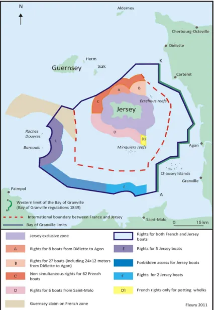
In terms of fishing, the waters surrounding the different islands can here be considered by their inhabitants as a protective zone that needs to be safeguarded. For this reason, in Jersey, the possibility offered by the Treaty of the Bay of Granville to French trawlers to come and work up to three miles from the shore – harking back to a pioneer agreement in 1839 – has not been appreciated by the public (Figure 1). In Guernsey, the authorities are endeavouring to find legal means of restricting the ‘foreign’ intrusions as much as possible within the 12-mile limit. The inverted commas are necessary here in as far as these manoeuvres are not only against their French neighbours, with whom there is considerable disagreement, but also towards fleets from Great Britain and even from neighbouring Jersey. The bailiwicks of Jersey and Guernsey are strictly independent of each other and turn respectively more to London than to one another when it comes to settling differences amongst neighbours. But in the Bailiwick of Guernsey, the islands of Alderney and Sark each have their own territorial waters stretching up to a limit of three miles from their coast, over which their courts have the power to control fishing activities, notably through the granting of licences. Management of the fishing in the Bailiwick waters outside the respective three-mile limit is in the hands of an organisation, on the board of which sit representatives from the three islands, the Bailiwick Fisheries Management Commission (BFMC)5. This so-called ‘grey’ zone – contrary to the
three-mile strip surrounding the islands – is subject to unwanted intrusions by ships coming from Great Britain or from Jersey (between 3 and 12 miles) and from France (between 6 and 12 miles) because of historic rights (Fleury, 2011). The Channel Islands illustrate the ambivalence of the symbolic relationship between island communities and the sea that has been crossed for thousands of years and that constitutes a link between the different islands at the same time as it represents the possibility of maintaining their particular individuality and of distancing them from the ‘others’.
_________________________________________________________
!
Figure 1: The Fishing Agreement for the Bay of Granville (July 2000)
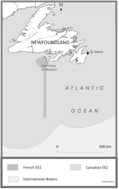
On the other side of the north Atlantic, the perception of the surrounding sea space has a surprising symbolic dimension in the case of another archipelago, Saint-Pierre-et-Miquelon, even if economic considerations are far from absent. This last of the French possessions in North America has had a stormy relationship with Canada over the sovereignty of the waters that are around it (Fleury, 2004). The wish of the two rival states to get their respective rights recognised has filled many press columns and the sector has long been a cause for envy because of its abundance of fishing resources. Any hope of a bilateral agreement on the French EEZ around Saint-Pierre-et-Miquelon was abandoned towards the end of the 1980s and the two countries took the issue to an arbitration tribunal in New York where France pleaded in favour of equidistance, which
_________________________________________________________
would have given it an EEZ of about 48,000 km!, whereas Canada advanced the idea of special circumstances to ask for the granting of a zone of just 12-nautical miles to the French archipelago. In 1992, the tribunal, much to the annoyance of the inhabitants of the archipelago, recognised the Canadian position by granting to France a zone the size and shape of which still fuels their resentment (Figure 2). Not only is the area – 12,400 km! - far short of what the French had wanted but the shape of its extension towards the
!
!
Figure 2: Saint-Pierre-et-Miquelon’s EEZ
south, forming a 200-nautical miles long and about 11-nautical miles wide corridor, is an obstacle to any viable economic exploitation, whether for its fishery or the tapping of oil
_________________________________________________________
fields. In 1996, the inhabitants of Saint-Pierre-et-Miquelon had further reason to protest following the Canadian decision to take Sable Island (175 kms off the coast of Nova Scotia) into account as the basis for the extension of its EEZ to 200 miles towards the open sea. The knock-on effect of this unilateral decision was that the French zone was hemmed in by the Canadian one.
When I was doing fieldwork in Saint-Pierre-et-Miquelon in 2002, what struck me was the importance of the cartographic representation of the EEZ around the archipelago for its inhabitants with regard to the way in which it illustrated their feeling of being ‘shut in’. While this extremely rare - if not unique - situation has of no effect on the free movement of shipping, it complicates tremendously the possibilities of extending Saint-Pierre-et-Miquelon’s continental shelf up to 350 miles from its coast.
Let us now look at a third case, one of a border island, Trinidad, the principal island of the Republic of Trinidad and Tobago (henceforth T&T). The border issues involving the island and its two marine neighbours (Venezuela and Barbados) have many faces and would justify further elaboration. But in the context of this discussion on the nature of aquapelagic assemblages, it is most pertinent to focus on the situation of the small fishing communities of the Cedros Peninsula, in the south west of Trinidad, close to the Venezuelan coast (Figure 3). 16 kilometres wide, the sea area known as the Serpent’s Mouth separates Trinidad – the most southerly of the Caribbean islands – from the South American continent. On the Venezuelan side, the mangrove zone, shaped by the alluvial deposits of the Orinoco River, only contains a few scattered fishing villages over several hundred kilometres of coastline. This amphibious coastal strip is considered to be a zone conducive to certain types of trafficking - mainly drugs, arms and wild animals – fostering the image of an insecure sector, located at the mouth of a huge river passing through virtually deserted areas and flowing into the Atlantic. At present, the sea border between T&T and Venezuela is in a sector where the border states do not fully assume their sovereign powers, especially as far as safety of persons and border controls are concerned, with frequent incidents occurring (see Sookraj, 2011, for instance).
On the T&T side, state employees for maritime affairs confirmed to me in 2003 that the authorities had not been in favour of replacing ships provided to them by the USA but which were no longer serviceable. In any case, according to one official, “there was no cause to intervene between the Trinidadian fishermen and the Venezuelan police”; the same person went on to say that new ships would be more usefully employed in the north monitoring the gas pipeline which has allowed the small Caribbean republic to become the leading supplier of liquid natural gas to the USA. Nine years later, suitable vessels to allow the T&T Coast Guard to give protection to T&T fishermen have still not been provided, a situation that has provoked national concern and that prompted the Trinidad and Tobago Guardian newspaper to publish an editorial that asserted that:
The matter of T&T’s maritime security can never be treated lightly. Litigation with Venezuela has been particularly complex and for decades, dating back to the colonial period, it has taken on various dimensions— territorial (maritime boundaries) and economic (fishing, hydrocarbons)… Experiences dating back just a decade or two ago are reminders of how easily and quickly these matters can take a more serious turn. In the not too distant past the Guardia Nacional has violently boarded T&T fishing vessels, resulting in deaths and injuries. The sea between the two countries is a zone for heavy shipping traffic and it is all too easy for a climate of violence and insecurity to develop. (2012: online)
_________________________________________________________
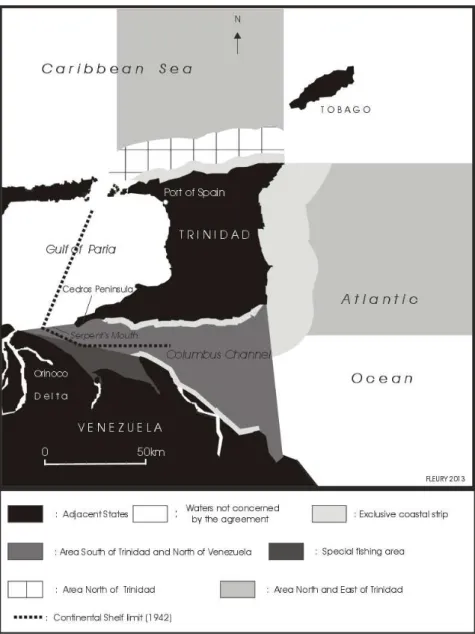
On the Venezuelan side, members of the Guardia Nacional, provided with efficient naval craft, more or less left to act on their own in peripheral areas a long way from Caracas, were the object of resentment by the fishermen in the south of Trinidad who lived on and by the strait. They take advantage in this way of a situation arising from a process of establishing a borderline that has not paid sufficient attention to the conditions necessary for local fishermen to exercise their traditional occupation. In 1985 a reciprocal agreement allowed trawlers from both countries to fish in certain zones in the other’s waters. The zone to the north and east of Trinidad is open to Venezuelan fishermen whereas the zone south Trinidad/north Venezuela is open to Trinidadians (Figure 3). Furthermore, another fishing zone was defined to allow small shrimp-fishermen from the south west of Trinidad to continue to fish in the nearby Venezuelan mangrove areas. This provision was dropped when the agreement was updated in 1997. It must be said that while reports of fishing incidents including various degrees of violence appear from time to time in the Trinidadian press, the real issues about sea borders between the two countries are to be found at a different level, that of the major manoeuvres linked to the exploitation of the very rich resources of oil which have made the two countries into leading players - on the world scene for Venezuela and regional for Trinidad and Tobago - in what is at stake (Baesdeo and Mount, 2001). The perspective of being able to share the cross-border deposits explains the speed with which the two neighbouring countries (whose relations are far from always cordial) produced a bilateral agreement on the drawing up of the borders (Fleury, 2008). This circumstantial collusion complicity is best expressed through the adverse consequences for the Republic of Guyana concerning its terrestrial dispute with Venezuela over the 1990 Treaty6(see Unattributed, 2011) which provided Venezuela with an advantageous
eastern extension to the first marine boundary established between the UK and Venezuela in 1942 (Figure 3).
Many Trinidadian fishermen have been arrested, sometimes imprisoned and their boats and catches seized. The list of different offences – injuries, disappearances and murders – attributed either to the Venezuelan Guardia Nacional or to non-identified aggressors is very long. The impunity that is a feature of these acts of violence brings us back to the criticism of the Trinidadian government’s lack of interest in the problems of the small fishermen in the extreme south-west of the island.
Aware of their relative impotence in the face of the industrial fishing lobby based in Port of Spain, which a reading of the 1997 agreement suggests is the only body to profit from its alleged advantages, my informants identified the lack of a political effort by their country as far as Venezuela is concerned. According to the 1985 agreement, the suggested number of working vessels from Trinidad with access rights to the special Venezuelan zone was already considered insufficient and the terms of renewal so ambiguous that the legal provisions seem to have diminished gradually in the absence of any administrative control.
_________________________________________________________
!
Figure 3: The 1985 agreement between Trinidad and Tobago and Venezuela7
The situation outlined above worsened after 1997, as the fisherman, exhorted in vain by their government to deploy their trawlers in other areas, continued to exploit their traditional fishing sectors on the continent, As one fisher from Icacos observed:
The best places for shrimps are on the Venezuelan coast and also inside the mangroves. Otherwise, fish are caught in the Gulf of Paria or in the common zone. The trawlers coming from Port of Spain lay waste to the sea bed. Going into Venezuela waters is essential. It is there that are to be found the largest concentrations of fish. We have always fished there by
_________________________________________________________
advancing into the mangroves, and then following the branches that connect eventually with the Orinoco. (Carlos X, p.c. April 2003)
There is no doubt that some fishermen from Cedros do not observe the 1997 agreement. But their infringement has its price, the US$300 that they have to give to the officers of
Guardia Nacional if they are caught. This obligatory payment is furthermore included in
the management costs of the boats. The way it normally works is that the catch is divided between the owner, coverage of the boat overheads, the boat captain, the crew and a share for the Venezuelan maritime police. But even between 1985 and 1997 when an access permit was supposed to suffice to be able to fish freely in the zone, it was not an absolute guarantee, as one fisherman put it to a journalist: “Permit or not, when yuh see dem wahlia is time to pull up line and run” (walhia is often used to describe the
Guardia Nacional amongst the inhabitants of the south of Trinidad). The fear that this
force causes amongst the Trinidadian fishermen is embodied in the person of the captain of a gun-boat described in the true style of a pirate, who skims across “the stretch of water between Icacos and the Venezuelan main with impunity and brings no end of terror into the hearts of the seamen” (Mannah, 1997: 16).
Conclusion
Ontologically, geographical spaces are characterised by a certain number of dichotomies, eg town/country, plain/mountain for example; the most readily apparent, distinct and unavoidable of which is, without doubt, the dichotomy land/sea. And yet the elements that we have adumbrated above are signs of the densification, intensification and diversification of the relationship between communities and the vertical sea space. The appeal of the concept of ‘maritory’ comes from the fact that it establishes a difference in terminology from territory (itself, a land-focussed concept), and provides a link through sound-association with the integration process of marine/ territory. In this context, the islands, as intermediate spaces, play a special role. Innately concerned with the fishing or energy resources of the marine space which surrounds them, their inhabitants often – but not always, as Hayward (2012b: 2) points out (in a comment which it would be worth developing concerning the individual nature of the relationship with insularity) – assume a symbolic relationship with the surrounding space. This relationship is ambiguous: the aquapelagic assemblage described by Hayward (2012a, 2012b) and Suwa (2012) emphasises the link created or to be created between the two elements, sea and land. Concepts of a protective cover, of a holy place, tend to promote isolation and resistance. For their part, the Trinidadian fishermen are in daily contact with what in many respects are dangerous waters. The combination of legal, social, spatial and temporal issues leads to a concept of the marine space as a set of different levels of mosaics formed of elements of size, of social density, of social relationships which are more or less harmonious and extremely variable. This task of social differentiation has been widely undertaken along the coast, the zone of contact between land and sea and which provides an interface at certain points. It too has encountered its zones of strong social pressures, its conflicts of usage, its neglected interested parties. As for the sea, it appears that it is a work-area that is still in its infancy. As such, it has prospects and offers a promising research field in which the islands have a real place. Chorographing the sea by highlighting the paradigm of the three-dimensional maritory, offers one clear way of giving Island Studies a dynamic impetus.
_________________________________________________________
Endnotes:
!!!!!!!!!!!!!!!!!!!!!!!!!!!!!! !!!!!!!!!!!!!!!!!!!!!!!!
1
The largest cruise vessels carry more than 8,000 people (crew included). 2
In Germany alone, no less than 30 farms in the North and Baltic seas are already planned, involving the installation of about 5000 wind turbines (L’Atlas des enjeux
maritimes, 2012, Le Marin).
3
See m.futura-sciences.com - accessed February 2013 4
See Article 1519 B, amended by Decree n°2012-653, May 4 2012 and Article 1519 C, amended by law n°2010-874, July 27 2010 – art. 91 (Journal Officiel de la République
Française).
5
See Burke (2012). 6
See Treaty between the Republic of Trinidad and Tobago and the Republic of Venezuela on the delimitation of marine and submarine areas, 18 April 1990, online at:
www.un.org/Depts/los/LEGISLATIONANDTREATIES/PDFFILES/TREATIES/TTO-VEN1990SA.PDF 7
Source: The Fishing Agreement between the government of the Republic of Trinidad and Tobago and the government of the Republic of Venezuela, November 26 1985.
Bibliography
Basdeo, S and Mount, G (2001) The Foreign Relations of Trinidad and Tobago
(1962-2000): The Case of a Small State in the Global Arena, San Juan-Trinidad: Lexicon
Burke, C (2012) ‘Focus on Guernsey’, Fishing News August 10: 10-16 Fleury, C (2004) “Saint-Pierre-et-Miquelon, îles frontière”, Norois n190: 25-40
(2008) ‘L’articulation des enjeux géopolitiques et socio-économiques sur l’espace marin: l’exemple de la zone frontalière marine entre Trinidad-et-Tobago et le Venezuela’ (‘The articulation of geopolitical and socio-economic space: the case of Trinidad and Tobago and Venezuela’), in Taglioni, F and Théodat, J.M (eds) Coopération et intégration:
perspectives panaméricaines (‘Panamerican perspectives on coopération and
intégration’), Paris : Éditions L’Harmattan: 135-164.
--- (2011) ‘Jersey and Guernsey: two distinct approaches to cross-border fishery management’, Shima: The International Journal of Research into Island Cultures v5 n1: 24-43
Hayward, P (2012a) “Aquapelagos and Aquapelagic Assemblages”, Shima: The
International Journal of Research into Island Cultures v6 n1: 1-10
--- (2012b) ‘The Constitution of Assemblages and the Aquapelagality of Haida Gwaii’,
Shima: The International Journal of Research into Island Cultures, v6 n2: 1-13
_________________________________________________________
!!!!!!!!!!!!!!!!!!!!!!!!!!!!!! !!!!!!!!!!!!!!!!!!!!!!!!!!!!!! !!!!!!!!!!!!!!!!!!!!!!!!!!!!!! !!!!!!!!!!!!!!!!!!!!!!!!!!!!!! !!!!!!!!!!!
Needham, S (2009) ‘Encompassing the sea: maritories and Bronze Age maritime interactions’, in Clark, P (ed) Bronze Age Connections: Cultural Contact in Prehistoric
Europe, Oxford: Oxbow Books: 12-37
Parrain, C (2012) ‘La haute mer: un espace aux frontières de la recherche géographique’ (‘The High Seas : a spatial frontier for geographical research’), EchoGéo, online at: echogeo.revues.org/12929; DOI: 10.4000/echogeo.12929 – accessed February 2013 Robin des Bois (2013) ‘Après l’étalement urbain, l’étalement marin’ (‘After the urban sprawl, the marine sprawl’), Le Marin January 25: 22
Sookraj, R (2011) ‘Fishermen face hardship’, (Trinidad and Tobago) Guardian Media July 10, online at: guardian.co.tt/news/2011/07/10/fishermen-face-hardship - accessed March 2011
Suwa, J (2012) ‘Shima and Aquapelagic Assemblages: A commentary from Japan’,
Shima: The International Journal of Research into Island Cultures v6 n1: 12-16
Unattributed (2011) ‘How Trinidad Recognized Venezuela’s Claim to Most of Guyana’s land’, Notes from the Margin website:
http://notesfromthemargin.wordpress.com/2007/07/27/how-trinidad-recognised-venezuelas-claim-to-most-of-guyanas-land/ - accessed March 2013