To cite this document:
Luque-Ribas, Sergi and Hernandez, Daniel and Zenou, Emmanuel
Guided Descent to Mars. Vision-based Localization System for a Mars Probe. (2014) In:
11th International Planetary Probe Workshop (#IPPW11), 16 June 2014 - 20 June 2014
(Passadena, CA, United States). (Unpublished)
Open Archive Toulouse Archive Ouverte (OATAO)
OATAO is an open access repository that collects the work of Toulouse researchers and
makes it freely available over the web where possible.
This is an author-deposited version published in:
http://oatao.univ-toulouse.fr/
Eprints ID: 12095
Any correspondence concerning this service should be sent to the repository
administrator:
[email protected]
GUIDED DESCENT TO MARS. VISION-BASED LOCALIZATION SYSTEM FOR A MARS PROBE. S. Luque Ribas1, D. Hernandez2 and E. Zenou1, 1ISAE (10 Avenue Édouard Belin, 31400 Toulouse, France, [email protected]), 2Devil-Hop (11 Route des Bardis 31320 Rebigue, France), 3ISAE.
Introduction: The Vision-based Navigation Sys-tem designed aims to provide a better navigation feed-back to the control systems and increase the landing precision of the probes. The frame mission is the Mars Minor project of ISAE TAS-ASTRO Master, a low cost and low weight lander mission to Mars.
This navigation system will start operating at around 15 km altitude, once the speed is reduced after the re-entry phase. A small hole is opened to allow the camera to start taking images of the surface.
System Design: The algorithm which obtains the position and velocity of the probe has been structured in two separate processes: absolute localization and
motion estimation.
Feature points database. Prior to the launch of the
probe, the database of images [2] is preprocessed in order to obtain characteristic points [3]. These points are described and then stored on the memory of the probe. By doing this, the size of the database is re-duced drastically, as well as the onboard processing time, compared to a raw image.
Absolute localization algorithm. A first position
es-timation is provided by the Inertial Measurements Unit (IMU) onboard the probe and gross position estimation provided by the Earth control center. It is used to filter the database according to the position of each charac-teristic point. In addition, the points are also filtered according to local solar time, to increase the similari-ties between the surface images taken by the probe and the database images. The selected part of the database is then matched with the points obtained from the sur-face image coming from the probe’s camera, providing the latitude, longitude and altitude of the probe.
Motion estimation algorithm. A first initial
posi-tion, coming either from the IMU or the absolute local-ization algorithm is required. This algorithm compares the feature points extracted from two successive imag-es. It estimates the relative movement of the points along the second image and, together with the first ini-tial position and the elapsed time, it is able to estimate the new position and velocity.
Simulation: The system, comprised by the abso-lute localization and motion estimation algorithm, has been implemented in Matlab.
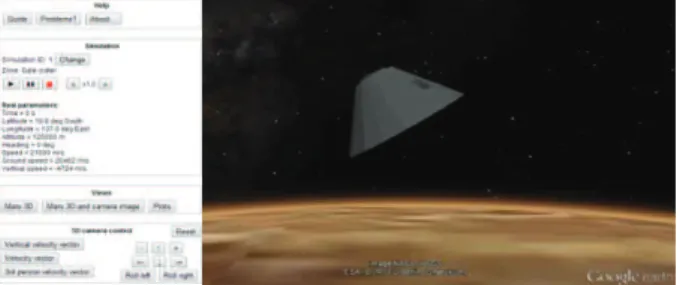
The simulation visualization has been designed in order to be easy to use no matter the computer used. A web-based interface has been designed (freely availa-ble at www.marslanding.tk), which is aavaila-ble to run in most browsers and operative systems (Figure 1). The
page is based in HTML language combined with CSS to structure and organize its elements. JavaScript is used to provide dynamism to the page and to com-municate with the Google Earth API [4] and the Flot libraries [5]. These last two are responsible to show, respectively, the 3D visualization of the descent and the data plots coming from the trajectory generation and estimation of the system.
Figure 1. Simulation interface with the 3D visualization Conclusions: The algorithm is capable of reaching a mean error of 13.4 px, compared to the database res-olution, which is translated to around 75 meters over the ground. The computing performance is able to exe-cute the algorithm in a reasonable time, around 0.62 seconds for the absolute localization algorithm. The combination with the motion estimation algorithm, which is 10 times faster, allows reducing the total com-puting time, making possible an embedded system on a real probe.
Versatility. The localization system can be used as
long as there is an image database and the surface does not change much in time, as on the Moon or other rocky moons of Mars. The web-based simulation makes it very easy to manage any localization data, being able to be used for other missions. It is also pos-sible to change from one celestial body to another, as long as the planet is represented by the Google Earth API.
References:
[1] Hernandez D. (2012) Mars Minor. [2] School of Earth & Space Exploration. Mars Image Explorer. [3] (June 2012) VL Feat-SIFT. [4] Google Inc. (March 2014) Google Earth API. [5] (March 2014) Flot.