HAL Id: halshs-02435333
https://halshs.archives-ouvertes.fr/halshs-02435333
Submitted on 10 Jan 2020HAL is a multi-disciplinary open access archive for the deposit and dissemination of sci-entific research documents, whether they are pub-lished or not. The documents may come from teaching and research institutions in France or abroad, or from public or private research centers.
L’archive ouverte pluridisciplinaire HAL, est destinée au dépôt et à la diffusion de documents scientifiques de niveau recherche, publiés ou non, émanant des établissements d’enseignement et de recherche français ou étrangers, des laboratoires publics ou privés.
Semantic Enhancement of a Virtual Reality Simulation
System for Fire Fighting
Aitor Moreno, Sisi Zlatanova, Bénédicte Bucher, Jorge Posada, Carlos Toro
To cite this version:
Aitor Moreno, Sisi Zlatanova, Bénédicte Bucher, Jorge Posada, Carlos Toro. Semantic Enhancement of a Virtual Reality Simulation System for Fire Fighting. Joint ISPRS Workshop on 3D City Modelling & Applications, 2011, Wuhan, China. �halshs-02435333�
Semantic Enhancement of a Virtual Reality Simulation
System for Fire Fighting
Aitor Moreno(1), Sisi Zlatanova(2), Bénédicte Bucher(3), Jorge Posada(1), Carlos Toro(1) (1) Vicomtech, Mikeletegi Pasealekua 57, 20009 San Sebastian, Spain
{amoreno, jposada, ctoro}@vicomtech.org
(2) Delft University of Technology, OTB, GIS technology, Jaffalaan 9, 2826 BX, Delft, The
Netherlands [email protected]
(3) Université Paris Est, IGN-COGIT. 73 avenue de Paris. 94160 Saint-Mandé, France
Abstract. Fires disasters provoke great destruction of high valuable environments
and economical losses, especially when they are located in urban areas. The usage of Virtual Reality Simulator to support the training process of fire fighters and managers has two main advantages: i) it supports the simulation of scenarios like big city fires that could not be simulated in the real world ii) it reduces the accident risks as users are trained to experience situations as ‘alike’ as possible to real fire. The success of the Virtual Reality Simulator depends on how close to reality the simulation process is; it also requires the integration of heterogeneous data sources like maps and cadastre. Both these aspects are met in this paper by a careful man-agement of semantics in the information system. Semantics are useful firstly to have a better model of the fire fighting process and a better adaptation of the simu-lation environment to the user profile. They are useful secondly to facilitate the in-tegration of data from heterogeneous sources. This work discusses and presents some preliminary results about how Semantic can enhance Virtual Reality Simula-tors in the fire fighting context.
Keywords: Semantics, Virtual Reality, enhancement, Fire fighting, formalisation,
ontology, real time, CityGML
1- Introduction
Virtual Reality simulators for fire fighting training are appropriate tools for presenting virtual and interactive scenarios impossible to be created in the real world. For example, a fire brigade cannot learn the practical aspects involved in a twelve-floor building fire emergency, since the variables involved cannot be re-created in a physical simulator. Only small and controlled drills can be performed within the security measures of pro-fessional training centres (see Fig. 1). The evolution of Virtual Reality simulators have been addressed by an increment of technical aspects like i) the graphic quality of the 3D world rendered, ii) their screen resolution, iii) stereoscopic support, and iv) the addition of novel interaction devices, aiming to increase the users immersive experience. The aforementioned benefits make possible the development of very realistic simulations for the training of fire fighters.
Fig. 1: Aircraft Rescue and Fire Fighting Basic Training [26] [11].
Emergency Response field require access to information and knowledge that comes from different and, in many cases, heterogeneous sources, i.e., the terrain data could be provided by a Map Server provider, the roads and street information or the cadastral data could be provided by the local territorial authority, or even the status of the semaphores in a given area could come from traffic and urban designers ([33]). Additionally, 3D models are becoming widely available and can be obtained from municipalities or other institutions, making the heterogeneity of sources a very tricky task to conceive ([32]). All these data are created and maintained by different authorities with application focus, which results in use of different terms, classifications and modelling approaches. Fur-thermore, the Emergency Response methodologies are region/country dependent, as they describe specific actors, processes and tasks, and also may have diverse terminology. In this respect, there is a broad understanding that the use of semantic technologies intro-duces valuable modelling tools and underlying languages, which is advantageous for the unification of the concepts and terms behind the terminology used in the heterogeneous data sources (on one hand) and the terminology of each Emergency Response region (on the other hand).
In simulation environments, the categorisation of user roles is a key element, since it is closely related to the users’ perception of the 3D world. Within a described simulation scenario, the users have different interaction paradigms with the system, which depend on their roles in the emergency response process. If these roles are well-defined the im-mersive experiences can increase significantly, which will effectiveness of the training. For example, immersive simulations with detailed models are more suitable for agents on the field. Some additional information such as water hydrants, target building, etc. would further increase the immersiveness. For managers, the coordination of the re-sources is a critical task; therefore, the simulator should provide all the available infor-mation, like 2D and 3D maps, available resources mapped in real-time and their status.
The support for this behaviour can be realised by adding a Semantic Layer to the VR system. Eventually, the Semantic Layer will provide necessary information for two im-portant processes: first the integration of data from various sources, second the adapta-tion of the simulaadapta-tion environment to the user profile.
This work will elaborate on some preliminary analysis about the possible semantic enhancements by adding a Semantic Layer in the VR Simulator. Some custom tests are shown in the corresponding section to help to understand the possibilities of the semantic enhancement of VR simulations.
2- State of the Art
2.1 The various meanings of semantics in geographical information systems
Semantics is the discipline that studies the meaning of things. The word originates from the Greek term semantikos that means “significant”. The word semantic in its modern form is considered to have first appeared in French as sémantique in Michel Bréal’s 1897 book, Essai de sémantique [05]. Semantic technologies constitute some of the most interesting technologies derived from the World Wide Web revolution. Constantly re-viewed in different areas of knowledge (e.g. Linguistics), their greatest improvements of information technologies might still be yet to be discovered.
In the domain of Geographic Information, the word Semantics has been used fre-quently somehow to refer to the improvement of the information system by explicating more information, but with different interpretation of what semantics are in an infor-mation system. The remaining of this section reviews these different interpretations and their relevance in our context.
Very early, geographical data producers used the word semantics to refer to the part of geographical data that were related to the thematic properties of features and their attributes like a “number of lanes” for a road. In many virtual models, there are two sorts of data: the coordinates and the textures. Enriching such data with semantics can thus be interpreted as follows: making explicit, at the level of data, the features as well as their nature and properties. This is what is proposed in CityGML model [20]. The authors use semantics to denote properties different from spatial ones. They propose to integrate in CityGML semantics elements relevant to disaster management thanks to a taxonomy of classes that distinguishes between buildings, vegetation objects, water bodies, and trans-portation facilities like streets and railways. These objects are useful to support automat-ed analysis like finding the quickest way to a building.
Another basic definition of semantics proposed by Kavouras et al [18] is the relation-ship between the data and the reality. Many works analyse how to represent this infor-mation, essentially in order to integrate heterogeneous data or in order to facilitate da-taset discovery in catalogues. Most approaches consist in associating a real world feature type (also known as a category in an ontology) to a database feature type [19]. Mustiere et al. [25] and Abadie [01] propose a more precise representation of the relationship be-tween a geographical database representation construct and a category of the real world. Their model tracks every choice made by the data producer to create the database struc-ture and to populate it from his observation of the real world, like the decision to decom-pose the representation of a road into road segments or the decision not to put in the da-tabases dead ends that are less than 20 m. long. This meaning of Semantics is much used in works related to the integration of heterogeneous databases, described in the next sec-tion. It is what we call nature-oriented semantics.
Kuhn has a different point of view on semantics, summarized in the following state-ment of the author: meaning is the use [21]. This is what we call the value-oriented
in-terpretation of Semantics as compared to the preceding nature-oriented inin-terpretation.
An interesting work in this perspective is the proposal of the economist Gibson [14] to describe the word in terms of what activities are supported by the objects, i.e. the af-fordances: “The affordances of the environment are what it offers the animal, what it
provides or furnishes, either for good or ill”. Kuhn [22] extends upon this work and model affordances in Geographic Information Systems. Similarly, Jordan [17] proposes to use affordances as relevant descriptors for places: a place to rest, a place to have a drink, and so on. In the context of fire disasters, affordances can be analysed in the per-spective of several processes: the fire (example of affordances are objects that burn well), escaping from the fire (examples of affordances are objects that can be a good shelter waiting for the rescue team), fighting the fire and rescuing people (example of affordances are water body and pumps to extinguish the fire). In our context though, only the fire fighting process will be studied. This meaning of semantics needs somehow to have a formal model of human activities to assess possible affordances of objects in these activities [07]. A formal model for fire fighting process is presented in section 2.3.
2.2 Formalising semantics to integrate heterogeneous data
Generally, three kinds of data interoperability, namely system, syntax and structure, and semantic interoperability [27][04]. System refers to hardware, operating systems, and communications heterogeneity, such as communication protocols. Syntax and structure interoperability covers data representation, formatting, data models, spatial schemas het-erogeneity. Semantic interoperability reflects the meanings of objects, terms, features, code, message or any other form of representation. While quite some progress is realised in solving heterogeneity of the first to groups, the semantic interoperability is the most challenging. With the development of Spatial Information Infrastructures (SII) the se-mantic interoperability is becoming a critical issue to be dealt with.
One of the formal approaches to describe semantics formally is ontology. Ontology in broad sense stands for the philosophical study of the nature of being, existence or reality. In theory, ontology is defined as an explicit and formal specification of a conceptualiza-tion [15]. There are two important aspects in this definiconceptualiza-tion: explicit (i.e. the meaning of each concept and their constraint are defined clearly) and formal (i.e. the ontology is defined by the well-defined, machine-readable language). Therefore ontology is seen as a very promising approach for dealing with semantic interoperability. Theoretically three kinds of ontology architecture can be distinguished [27][29]: global, peer-to-peer and hybrid ontology architecture. Global ontology architecture assumes the existence of a single big ontology for the application field. All concepts and relations are well-defined by this ontology without referring to other ontologies. This architecture is suitable for the application domains where all parties have a common understanding and agreement. Peer-to-peer ontology architecture refers to cases when several ontologies are used as the mappings between them are known. These ontologies could also form a new concept and a relation network as the global ontology architecture. This architecture is more flexible but it might happen that many abundant data may exist. Furthermore, costs and time to build such architecture might increase a lot. Hybrid ontology architecture is a combina-tion of the above two. In this architecture, domain ontology is build and other specific ontologies refer to it. A commonly agreed definition and constraints of domain vocabu-lary are defined in the domain ontology.
Heterogeneity of geo-spatial data for emergency training may benefit of the second and the third approaches [31]. This means that a domain ontology for emergency re-sponse should be built, that further can be mapped to the ontology of users (having also
domain ontology, such as domain ontology for fire-fighters, domain ontology for police, etc.) and ontology of data (such as ontology for topographic data sets, ontology for ca-dastre, etc’s.
2.3 Formalisation of the fire-fighting process
Emergency response procedures and the organisational structures may differ significant-ly per country. Some countries are exposed to earthquakes, others to flood and fires; fire brigade and police might be the primarily responders in some countries, while in others civil protection centres or other governmental institutions may take the lead. In all cases, however, the local and national governments and the international organisations have legislations that prescribe work-flows and procedure for emergency response. Consider-ing these documents and analyzConsider-ing the work of the emergency responders, it is possible to specify what kind of data might be of primarily interest when performing a certain tasks [32]. The main components of this formal modelling are the actors, their tasks and the information they need to have at their disposal and usually, the language used is Uni-fied Modelling Language (UML).
The goal of extinguishing a fire is to prevent further damages on property and limit emission of dangerous substances. The workflow can be quite specific but has several common key elements as follows: the call centre receives the emergency call, registers the incident and informs the responsive fire brigade unit. The officer in duty (and the needed fire engines) moves to the area of the fire. On the way to the fire they examine various pieces of information such as different topographic maps, locations of water re-sources (open water and hydrants), the optimal route to the area, vulnerable objects in the area (available on risk maps), information about citizens, etc. If the fire covers a large area (as it often happens with forest fires), a regional operation team (ROT) is formed and coordinates the actions.
In this case the following actors can be distinguished: CallCentre, FBleader (of one fire enfine), OfficerDuty and ROT. The most important identified tasks for provid-ing/recording information are RegisterInsident, FightFire, Report, OperationalLead and
TacticalLead (see Fig. 2). For example, the task of the operator in the call centre is to register the incident and inform the fire brigade sector. FBleader is responsible for the direct actions for fire extinguishing of one team. The officer on duty performs the overall operational lead on the field. These two actors should be in regular contact report with
ROT.
As it can be seen, the information needed for the involved processes differ with re-spect to the actors. Some of them (operator in the call centre, FBleader & teams and the officer in duty) need large scale topographic maps (i.e. Topo1000, scale 1:1000). ROT (located in a command centre outside the dangerous area) needs small-scale map (Topo10000, scale 1:10000) and information about citizens, vulnerable objects (availa-ble through Risk Maps) and often utility maps (e.g. gas-pipe lines). Essential for the FBleader might be the information about water hydrants, HAZMAT information (in case of fire in industrial areas), access to public buildings and industrial establishments, etc. It is possible that some of the actors have more than one task. For example the FBleader and the officer of duty have to prepare reports. The reports can be even recorded in spa-tiotemporal data models [10].
Fig. 2: UML diagram representing tasks, actor and information for Fire Fighting (from [34]).
The process as described above can be further enhanced with actors, tasks and needed information for specific types of fires or scales and can be considered in the VR Simula-tor. The information provided by the VR simulator can be also adapted to the goal of the each specific training, e.g. for training of fire fighters on the field or for operational and tactical training of ROT.
3- Our proposed information model for a Semantic enhanced VR
Simulator
3.1 Fire fighting simulator capabilities
The VR system is aimed to help in the training or to improve the efficiency of the fire-workers (field agents, managers...). The common teaching procedure includes the theo-retical content and some practical examples, all of them with fake fire and with strong limitations, as it is impossible to fire a forest or a 12-floor building only to teach how to fight it.
The presented simulation system is oriented to the fire fighting procedures, in forest and urban areas. Some approximated algorithms of the fire spread have been modelled and developed [23], as real-time nature (since the fire fighters and managers interact with the fire) limits the complexity of the methods. Therefore, we cannot use the very well known and accurate fire spread algorithms existing in the bibliography.
In order to be able to simulate how the fire spreads and to model the behaviour of the users, the simulator will be provided by passive data coming from different sources and
dynamic events, not only including the user actions but also real-time changes in the weather conditions, for example.
The most important required information is the topographic information of the scenar-io where the fire simulatscenar-ion will be held, which includes the terrain itself (given as a Digital Elevation Map or DEM), the aerial ortophotos and the ground classification giv-en by disjoint zones, coming from any available GIS system [12]. Although very de-tailed information would be great, having at least a rough classification based on Water,
Roads, Urban Areas and Forest Areas is required.
The available topographic information is then pre-processed and sampled into the in-ternal field representation, based on a squared grid of autonomous cells, each of them containing geometrical information, such as position, side size, elevation and slopes [30]. Also, per cell information, related to the fire spreading algorithms, is also stored. It includes the type of the cell, the amount of initial fuel and the burning rate depending on its type.
The weather conditions are also required by the fire spread algorithm, being the wind direction and speed the more important considered physical variable [30]. Although oth-er parametoth-ers like humidity and global tempoth-erature are relevant for an accurate simula-tion, the wind speed and direction are considered the most influent variables.
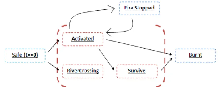
Fig. 3: The different states of a cell and the available transitions
In runtime, the fire spread simulator will calculate how the fire spreads step by step, following a set of rules [02] and storing the results in the tiles definition. The algorithm introduces the internal state of the tiles, with six possible values: Safe, Activated, Burnt,
Survived, RiverCrossing and FireStopped (see Fig. 3).
When a cell is in the Safe state, there is no fire in it. In the other hand, the Activated state indicates that there is an active fire in the cell. The Burnt state is the final state of a cell after being completely consumed by the fire. The Survived state is pseudo-final state, when the cell is burnt, but still has residual heat. Even being completely consumed by the fire, the cell can irradiate some heat to others cells. Eventually, the cell will pass to the Burnt state.
The RiverCrossing state is a hidden state used in the computation of the fire spread through a river or firewall, using the radiation effect. Finally, the FireStopped state rep-resents an intermediate state of a cell, when some external fire extinguisher has stopped the fire.
The simulator also deals with urban fires, so the fire spread algorithm includes the buildings concepts, adding the corresponding classifications and spreading rules [06]. The urban fire algorithm is an extension of the forest areas, and essentially, the algorithm
works in the same way. A Building is sampled into squared cells, applying the corre-sponding building type, and also, the number of floors as a key element. For the building types, we have considered three main types; following the classification introduced by Iwami [16] (see Fig. 4).
Fig. 4: Different types of buildings considered in the simulator. The Secure Unit is harder to burn,
and its final state is not destructive. The Wooden Unit and Shanty Unit are destructive fires, where the building burns totally and collapses. The Wooden Unit and Shanty Unit burns using different schemas [16].
The introduction of buildings into the fire spread algorithm required the addition of a set of specific rules to deal with the peculiarities of the urban fire [23]. The fire evolution in buildings with several floors should be considered as 3D, as the fire tends to go up-wards. Also, the radiation effect is stronger in higher floors, increasing the probability of fire spreading to near buildings. These rules are easily added to the fire spread algorithm, but the addition of the extinguishment support is more difficult to achieve.
In forest areas, the extinguishment support is simulated by adding the concept of Wa-ter Quantity to the cells. In fact, the waWa-ter concept is an abstraction of any extinguisher agent. In runtime, any amount of water thrown to an active cell reduces its amount of fire (FirePower) (see Fig. 5) by a given quantity, depending on the type of the extinguisher agent.
Fig. 5: Extinguishment support in the simulator is based on the “throwing water” concept, where
water cancels a determined amount of FirePower. The water disappear immediately if there is enough FirePower, or remains there as available water, which could be evaporated by the radia-tion effect coming from the neighbouring cells.
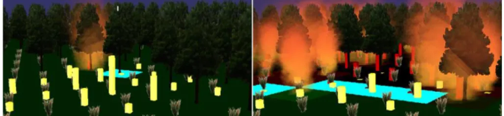
In urban areas, this algorithm is not easily scalable, as the building concept is much more complex than outside areas [28]. The real life procedures to deal with urban fires differ too much depending on the building, the surroundings, the available resources... In Fig. 6, some very different situations are shown. The extinguishment algorithm im-plemented for those situations are based on external water sources (water jets), thrown from large fire truck.
Fig. 6: Urban fire examples where the burning floors have been coloured in red to make them
distinguishable from the rest. The urban fire can spread to adjacent floors (up, left), upwards and downwards (up, right), to neighbouring buildings (down, left) and to the surrounding terrain (down, right).
3.2 Geographical 2.5D and 3D data analysis
Classical 3D virtual models, comprising a Digital Elevation Model (DEM) and realistic textures are very useful for the user visualisation. Indeed, a great difference between virtual globes and maps is that the virtual globe is closer to the user experience of the real world than the map. These data can be provided by data producers or can be simu-lated if a specific landscape or atmosphere is required. Besides this terrain information, objects are necessary to perform some analysis as explained by Kolbe et al. [20] when they present CityGML relevance for disaster management.
With respect to the fire fighting simulator introduced in the previous section, the rele-vant categories of objects are buildings (with the floors and indoor details), roads, urban areas and forest areas have been introduced. It is important to determine which dimen-sions are needed for these objects and which levels of details, because this could affect dramatically to the number and structure of the categorisation. For example, the classifi-cation of buildings could be extended in order to take into account the skyscrapers typol-ogy.
We distinguish between 2D, 2.5D and 3D data. In 2D representation, coordinates are only planimetric. In 2.5D there is one altitude for each planimetric coordinate (like a DEM). In 3D it is possible to describe several points with different altitudes and the same planimetric coordinates, like on a wall or when a bridge crosses a river. From an algorithmic point of view, sometimes 2D data is more suitable than 3D. The calculation of solar radiation or wind effect at street level do not require the same accurate represen-tation as the intervisibility problem, used to check if two objects (e.g., fireman and in-jured people) could see each other inside a building. This combination of 2.5D and 3D objects, as well as the combination of different levels of details of the data, leads to in-teroperability problems.
These problems become clearer when different heterogeneous data sources are used at the same time, for example, the terrain data, the buildings, the road networks and the water resources map (like hydrants, a very important element in the fire fighting pro-cess). Depending on the data resolution and scale, the hydrant location in the virtual
world could not be precisely aligned with respect to the terrain data as it would be re-quired in the Virtual Reality Simulator. The solution for these situations is based in the utilisation of multi-resolution data, assuring the data quality, alignment and integration at a specific level. CityGML, with their well defined 5 LoD, is a very handy 3D data repre-sentation, allowing unifying multiple data sources at a given LoD.
One last important element regarding geographical data in the system is to support the unambiguous designation of objects and places in a way that is both machine readable and human readable. This is useful typically for firemen, civilians or the manager to communicate on the phone relevant information about the scene. Street names and ad-dresses are the common human readable reference system for urban objects. But it might be useful to have other ones (for instance if a street name is destroyed or too far to read it). In most works, it is suggested to identify landmarks that can be used to reference things in a landscape. An interesting proposal is that of Morita’s real scale map who de-fines objects in the real world (like a fire light) that, together with relationships like “5 steps from” compose a fully functional reference system [24]. An alternative way to solve this issue is to design identifiers for objects in the real worlds. This approach is investigated in the context of collaborative data and in the Semantic Web where people want to attach descriptors to a resource identified with a URI. Yet, these URIs are not
that much human readable like for instance
http://data.ordnancesurvey.co.uk/id/50kGazetteer/16354. In our context, Morita’s
pro-posal fits better in the Virtual Reality Simulator implementation.
4- Exploiting the Semantic Layer in different scenario
The utilisation of Semantic technologies is a key element to introduce semantic concepts into VR application. The fire fighting simulator, presented in Section 3, could benefit of an integration of the semantic knowledge embedded in the fire fighting process.
As it has been address in Section 2, the formalisation of the fire fighting process trig-gers the categorisation and representation of different entities, processes, tasks, subtasks and roles.
The utilisation of this categorisation into the VR simulators could enhance the possi-bilities and features of the VR fire fighting simulator. The relationship between both modules is directional, i.e., the Semantic Layer can send semantic information to the virtual world and, in the other hand, the results of the actions of users in the virtual world can be retrieved by the Semantic Layer for further utilisation.
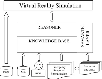
Therefore, the Semantic Layer (see Fig. 7) takes all the relevant information, com-posed by the GIS information, the user categorisation and all terms and concepts of the Emergency Response procedures into a set of ontologies, where the reasoning would produce direct input signals for the Virtual Reality Simulator. These input data can be conceived as an asynchronous signalling system, triggering changes in the VR while the users are online.
Fig. 7: The Semantic Layer manages the different kind of information that will be loaded into the
VR simulation. The Processes and Tasks are the result of the formalisation of the Emergency Re-sponse procedures related to the fire fighting process. User categorisation is addressed by the exist-ing roles in the processes and tasks. All this information plus all the relevant GIS information is used by the Semantic Layer to analyse and trigger all the semantic enhancements in the VR simu-lation. The cartographic information, 3D maps and static information of buildings are loaded di-rectly by the VR simulation.
In this work, some very simplified scenarios and examples will be addressed, in order to preview how the VR simulations could benefit from the Semantic Layer. These exam-ples have been chosen to fulfil a wide range of possible practical applications, but they should be understood as representative examples of a larger set of possibilities.
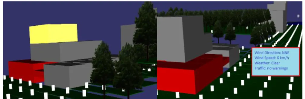
Use case 1: Semantic Highlighting of VR elements
The Semantic Highlighting of specific elements is the simplest way to enhance the VR simulations, as it is easy to implement and to understand. In this case, the Semantic Lay-er triggLay-ers visual changes in the VR, whose main purpose is to highlight specific ele-ments to be visually more distinguishable from the rest of the objects.
As an example in the fire fighting simulator, an agent field could receive relevant in-formation to locate a targeted ignited floor of a burning building, by rendering it with a distinctive red colour (See Fig. 8, left). The Semantic Layer would provide to the VR system the specific floor (and building) to highlight. The Semantic Highlighting takes advantages of the applied identifiers to the VR objects, allowing linking a given object by some descriptor.
maps GIS
REASONER
Virtual Reality Simulation
Emergency Response Formalisation Processes and tasks users
KNOWLEDGE BASE
SE
M
A
N
T
IC
L
A
Y
E
R
Use case 2: Overlay of queried knowledge
This use case is an extension of the Semantic Highlighting, where more complex infor-mation is used to enhance the VR elements. A typical usage of this technique would be used to indicate users on-screen information, e.g., the weather conditions, the manage-ment centre messages or step-by-step instructions to achieve a specific goal (See Fig. 8, right). The information to be presented will be the result of a semantic query triggered by the Semantic Layer and it will be provided to the VR system for its display or utilisation. Even though this technique can be categorised as an Augmented Virtuality technique [03], it goes beyond by using the Semantics to retrieve the information.
Fig. 8: Left) use case 1: Burning buildings (floors) have been highlighted in red, and the target
floor in yellow. Right) use case 2: Additional on-screen information is displayed, in this case, re-lated to weather and traffic conditions.
Use case 3: Enhance VR setup using user profiles
The VR setup is usually designed and implemented to fulfil the usability requirements from the target users, as a result of the specification process in the early stages of devel-opment. But, even in the same group of users with the same role, different people would require specific modification of the VR setup. Sometimes these modifications are only a matter of rearrangements in the GUI due to subjective reasons, but other times the modi-fications could be triggered from a semantic point of view.
If a user in the fire fighting management role is left-handed, the GUI (menus, toolbar, toolbox...) and mouse interaction behaviour could be adapted to improve the user experi-ence, since it is quite normal to produce unique GUI layout for right and left-handed people.
For immersive setups where a first or third person view point is normally used, the users could improve the virtual experience if the avatar height is similar to their own height. The VR setup should be adapted or reconfigured using the semantic information. Normally, the key element is the user role, which triggers different kind of visualization and different data retrieval methodologies.
Use case 4: VR elements replacement by user type
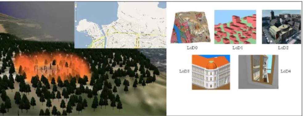
There are different elements which can be presented to the users in several ways. Even if the available hardware and software can handle with highly detailed 3D models and dense information, sometimes is preferable to used simplified models or impostors of the data, to increase their understanding of the information and the final usability of the ap-plications.
Fig. 9: Use Case 4. Left) Different resolution and types maps are used in the simulator. Right) The
different LoD that CityGML proposes in the specification [09].
In the fire fighting process, the field agents and managers in the control centre have different needs of data resolutions. In one hand, field agents using immersive simulators, will require highly detailed representations of their surroundings, rendering buildings and fire as realistic as possible. In the other hand, managers would not require such complexity, and a combination of cartographic layered 2D maps and a simplified 3D aerial view will suffice for them (see Fig. 9 left).
The proposed behaviour require to replace virtual elements depending on the user role and needs, being the Semantic Layer the responsible to tell to the Virtual Reality Simula-tors this kind of information, instead of hardcoding the VR elements replacements in the Simulator. CityGML model has support for well specified Level of Details, which allow selecting between different resolutions with respect to the needs of the users. They can be seen as a key element in the whole system. While a LoD 4 or 5 will be used by im-mersive simulators (fire agents), the LoD 1, 2 and 3 would be enough for the manager role (see Fig. 9 right).
5- Conclusions and/or Discussion and future work
This paper has studied the relevance of semantics in the context of Virtual Reality Simu-lators. Two kinds of enhancements are brought by semantics.
Firstly, nature-oriented semantics can improve the integration of data from different sources. The combination of multiple heterogeneous data sources (formal specification, maps, municipalities’ urban information...) is indeed a major problem from the acquisi-tion point of view. Required semantics to solve this are domain ontologies that should be
used to annotate the data. Besides, this information would also be used to access this information. We also propose to introduce a reference systems that is usable not by a geodetic surveyor but by actors involved in the process, in a way similar to Morita’s real scale map. This will facilitate the sharing of user comments and feed backs.
Second, value-oriented semantics, especially the modelling of the activities enhance the user experience. The proposed use cases in Section 4 show how Semantic Layer and Virtual Reality Simulator can be integrated to enhance the user experience. Uses cases 1 and 2 are more related to enhance the presentation of relevant information to the users. Use case 3 is a clear example of exploiting the user preferences or profile to modify how the 2D classical GUI or the equivalent 3D widgets can be adapted to fulfil the user needs. Finally, the use case 4 shows the ability of CityGML to deal with multiple LoD’s, as users require different data resolutions depending on their roles [08] [09].
Besides, the proposed information system relies on three types of semantic models: a model of tasks to organise the session, a model of reference system to organise some communication of information between involved agents, and a model of user profiles.
In this research, CityGML is considered as a major information model for the repre-sentation of 3D urban objects. On the basis of our initial investigations we estimate that the following enrichments of the CityGML model are needed:
Specific classes and/or attributes that will support the fire simulation algorithm like behaviours of specific type of floors.
Enhanced material properties to be used as visualisation clues to adapt the representation to the user profile.
Future work will concentrate on developing of the semantic models and integrating them in the Semanic layer of Virtual reality Simulator.
Acknowledgements. This work was supported by COST Action TU0801 "Semantic
Enrichment of 3D City Models for Sustainable Urban Development", and it was carried
out in the context of project SIGEM, funded by the Spanish Industry Ministry through its
Avanza I+D Programme.
References
[01] Abadie, N., 2009, Formal specifications to automatically identify heterogeneities, In: pro-ceedings of the 12th International Conference on Geographic Information Science (AG-ILE'09), Pre-Conference Workshop “Challenges in Spatial Data Harmonisation”, Hanover (Germany)
[02] Achtemeier, G. L., 2003. An Application of Stephen Wolfram’s “New Kind of Science” to Fire Spread Modeling, USDA Forest Service, Athens, GA.
[03] Ahuja, G., Kogut, G., Pacis, E. B., Sights, B., Fellars, D., Everett, H. R. 2007, Layered augmented virtuality. In RA ’07: Proceedings of the 13th IASTED International Conference on Robotics and Applications, pages 258–263, Anaheim, CA, USA, 2007. ACTA Press [04] Bittner, T., Donnelly, M., Winter, S., 2005, Ontology and semantic interoperability. In
Pros-peri, D., Zlatanova, S., eds.: Large-Scale 3D Data Integration: Challenges and Opportunities, CRCPress, Boca Raton, FL.
[05] Bréal, M. Essai de sémantique. Editions Lambert-Lucas, 3 edition, 1897, Re Ed. 2005. [06] Breton, T., Duthen, Y., 2008. Les simulations de propagation de feu en milieu urbain.
[07] Bucher B., 2003, Translating user needs for geographic information into metadata queries, In: 6th International Conference on Geographic Information Science (AGILE'03), Lyon (France) [08] CityGML Homepage: Exchange and Storage of Virtual 3D City Models:
http://www.citygml.org/.
[09] CityGML wiki: Collaborative wiki with all relevant links and tools: http://www.citygmlwiki.org
[10] Dilo, A. and Zlatanova, S. 2008, Spatiotemporal data modelling for disaster management in the Netherlands, in: Van der Walle, Song, Zlatanova&Li (eds.), Information Systems for Cri-sis Response and Management, Joint ISCRAM-CHINA, Gi4DM Conference, 4-6 August, 2008, Harbin, 4–6 August, China, pp. 517–528
[11] Draeger website, with fire fighting drills with real fire. http://www.draeger.com
[12] Dumond, Y., 2008. Forest fire growth modelling with geographical information fusion. 11th International Conference on Information Fusion, June 30 2008-July 3 2008 Page(s): 1 – 6. [13] Forest Fires Website, 2010. Statistics on Forest Fires,
http://library.thinkquest.org/07aug/01254/statistics.html . Last time visited: 15/05/2010. [14] Gibson, J.J., 1986, The Ecological Approach to Visual Perception. Lawrence Erlbaum,
Hills-dale, NJ, 332
[15] Gruber, T.R, 1993, A translation approach to portable ontology specifications. Knowl. Ac-quis. 5(2) (June 1993), pp. 199–220
[16] Iwami, T., Y. Ohmiya, Y. Hayashi, K. Kagiya, W. Takahashi and T. Naruse, 2004, Simula-tion of City Fire. Fire Science and Technology, 23(2), 132-140.
[17] Jordan, T., Raubal, M., Gartrell, B., and Egenhofer, M. , 1998, An affordance-based model of place in GIS. In : Eight International Symposium on Spatial Data Handling, pp. 98–109. [18] Kavouras, M., Kokla, M., Tomai, E., 2003, Determination, visualization, and interpretation
of semantic similarity among geographic ontologies, In: Gould, M., Laurini, R., Coulondre, S. (eds) Proceedings of the 6th AGILE Conference on Geographic Information Science, Lyon, France, pp51-56
[19] Klien, E., Lutz, M., Kuhn, W., 2006, Ontology-based discovery of geographic information services - An application in disaster management, In: Computers, Environment and Urban Systems 30(1) pp. 102-123
[20] Kolbe, T., Gröger, G., Plümer, L., 2005, CityGML – Interoperable Access to 3D City Models, In: Oosterom, P., Zlatanova, S., Fendel, F. (eds), Proceedings of the International Symposium on Geo-information for Disaster Management, Springer Verlag, Delft
[21] Kuhn, W. 1996, Semantics of geographic information. Geo-info series, Vol. 7, Technical university Vienna, Dept. of Geoinformation, Austria
[22] Kuhn, W. , 2001, Ontologies in support of activities in geographical space, In: International Journal of Geographic Information Science, 15(7), 613-631, Taylor & Francis Ltd., London, Great Britain
[23] Moreno, A., Segura, A., Korchi, A., Posada, J., Otaegui, O., 2010, Interactive Urban and Forest Fire Simulation with Extinguishment Support. 3DGeoInfo 2010, Berlin.
[24] Morita, T., 2007, Concept of a real scale map and the allocation of reference points in ubiqui-tous mapping, In : proceedings of the 23rd ICC conference, Moscow
[25] Mustière S., Gesbert N., Sheeren D., 2003, A formal model for the specifications of geo-graphic databases, International Workshop GeoPro on Semantic Processing of Spatial Data, 5-7 November, Mexico (Mexico)
[26] Rocky Mountain website, 2010. Aircraft Rescue and Fire Fighting Basic Training, http://www.rmestc.com/. Last time visited: 15/11/2010.
[27] Visser, U., Stuckenshmidt, H., Schlieder, C., 2005, Interoperability in GIS-enabling technol-ogies. In: AGILE Conference on Geographic Information Science, pp. 25–27
[28] Vitenys, B., and Richard, D. P., 1991. Heat Release Rate: The single most important variable in Fire Hazard.
[29] Wache, H., Vögele, T., Visser, U., Stuckenschmidt, H., Schuster, G., Neumann,H., Hubner, S.: Ontology-based integration of information — a survey of existing approaches. In Stuck-enschmidt, H., ed.: IJCAI–01 Workshop: Ontologies and Information Sharing. (2001) 108– 117
[30] Weise, D. R., Biging, G. S., 1996. Effects of Wind velocity and slope on flame properties. [31] Xu, W. and Zlatanova, S., 2007, Ontologies for disaster management response. In Li,
Zlatanova, Fabbri, (eds), Geomatics Solutions for Disaster Management, Springer verlag, Heidelberg, pp. 185–200
[32] Zlatanova, S., 2008, SII for Emergency Response: the 3D Challenges, In: J. Chen, J. Jiang and S. Nayak (Eds.); ISPRS Archives, the XXI ISPRS Congress, Part B4-TYC IV, July 2008, Beijing, pp. 1631-1637
[33] Zlatanova, S., P. van Oosterom and E. Verbree, 2006, Geo-information supports management of urban disasters, Open House International, Vol. 31, No.1, March 2006, pp.62-79
[34] Zlatanova, S. 2010, Formal modelling of processes and tasks to support use and search of geo-information in emergency response, In: Proceedings of the 13th International Conference and Exhibition on Geospatial Information Technology and Applications, Map India 2010, January, Gurgaon, 8 p.
![Fig. 1: Aircraft Rescue and Fire Fighting Basic Training [26] [11].](https://thumb-eu.123doks.com/thumbv2/123doknet/7766228.255976/3.893.241.673.221.373/fig-aircraft-rescue-fighting-basic-training.webp)
![Fig. 2: UML diagram representing tasks, actor and information for Fire Fighting (from [34])](https://thumb-eu.123doks.com/thumbv2/123doknet/7766228.255976/7.893.221.690.217.536/fig-uml-diagram-representing-tasks-actor-information-fighting.webp)