‘Q) ii
t!
?.ø%tà)
)
t,
The Settiement and Rural Domestic Architecture
of Côte Saint-Antoine,
1675—1874par
Janet 5. MacKinnon
Faculté de l’aménagement
Mémoire présenté à la Faculté des études supérieures en vue de l’obtention du grade de
Maîtrise ès sciences appliquées (M.Sc.A.) en aménagement (option conservation de l’environnement bâti)
Avril 2004
C
—
Direction des bibliothèques
AVIS
L’auteur a autorisé l’Université de Montréal à reproduire et diffuser, en totalité ou en partie, par quelque moyen que ce soit et sur quelque support que ce soit, et exclusivement à des fins non lucratives d’enseignement et de recherche, des copies de ce mémoire ou de cette thèse.
L’auteur et les coauteurs le cas échéant conservent la propriété du droit d’auteur et des droits moraux qui protègent ce document. Ni la thèse ou le mémoire, ni des extraits substantiels de ce document, ne doivent être imprimés ou autrement reproduits sans l’autorisation de l’auteur.
Afin de se conformer à la Loi canadienne sur la protection des renseignements personnels, quelques formulaires secondaires, coordonnées ou signatures intégrées au texte ont pu être enlevés de ce document. Bien que cela ait pu affecter la pagination, il n’y a aucun contenu manquant.
NOTICE
The author of this thesis or dissertation has granted a nonexclusive license allowing Université de Montréal to reproduce and publish the document, in part or in whole, and in any format, solely for noncommercial educational and research purposes.
The author and co-authors if applicable retain copyright ownership and moral rights in this document. Neither the whole thesis or dissertation, nor substantial extracts from it, may be printed or otherwise reproduced without the author’s permission.
In compliance with the Canadian Privacy Act some supporting forms, contact information or signatures may have been removed from the document. While this may affect the document page count, it does flot represent any loss of content from the document.
Université de Montréal Faculté des études supérieures
Ce mémoire est intitulé
The Settiement and Rural Domestic Architecture
of Côte Saint-Antoine,
1675—1874
présenté par JanetS. MacKin non
Cette étude se veut une enquête sur la colonisation et sur l’architecture domestique rurale de la Côte Saint-Antoine de 1675 à 1874. Cette période de deux siècles s’étend de l’achat de la première concession dans ce secteur à la création du village de Notre-Dame-de-Grâce, qui marque la fin de la vocation exclusivement rurale de la Côte.
Le développement de la Côte Saint-Antoine s’inscrit dans celui du système de routes nommées « côtes » conçu par Gédéon de Catalogne à la deuxième moitié du XVIIe siècle.
Il est important pour cette étude de bien cerner la signification du terme « côte », lequel
constitue une unité d’organisation territoriale ainsi, <t Côte Saint-Antoine » n’était pas
que le nom de la voie, mais aussi celui d’une collectivité rurale. La Côte Saint-Antoine fut l’une des premières <t côtes » colonisées de l’île de Montréal, peu de temps après le
Coteau Saint-Pierre et la Côte-des-Neiges. La colonisation initiale s’est déroulée au cours des trente années entre 1683 et 1713 la plupart des premiers résidents provenaient des côtes voisines.
La topographie de la Côte Saint-Antoine était importante au développement du secteur. Située sur les versants sud du sommet ouest du mont Royal et sur un plateau surplombant l’escarpement, la Côte Saint-Antoine bénéficiait d’un drainage et de conditions climatiques favorables à des activités agricoles aussi profitables que diversifiées. Les beaux paysages et les vues panoramiques de la ville, de la plaine et du fleuve en contrebas ont eux aussi contribué à attirer de nouveaux résidents — l’élite
marchande — au cours des années 1800. Tous ces facteurs ont été déterminants pour le
développement de la Côte Saint-Antoine.
Les projets d’architecture réalisés durant les années sur lesquelles porte l’étude incarnent toute une gamme de styles, en commençant par les premières maisons rurales de la Nouvelle-France — maisons pièce sur pièce, à colombages et en pierre des champs — qui représentent le passage des demeures en bois aux constructions en pierre, ainsi que
l’évolution des demeures rurales construites dans la région de Montréal au cours du XVIIIe siècle.
Le développement à compter du XIXe siècle a conduit, progressivement, au morcellement des fermes, à la construction de villas et de chalets sur les grands pâturages, et finalement, à l’introduction de la maison unifamiliale isolée donnant sur la rue. Ces changements ont marqué l’urbanisation du secteur et sa transformation en quartier résidentiel de prestige.
Mots clés : Côtes, colonisation rurale, agriculture, architecture domestique rurale, maison de ferme, villa, cottage, maison unifamiliale.
The study encompasses an investigation into the settiement and rural domestic architecture of Côte Saint-Antoine from 1675 to 1874. The 200-hundred-year period begins with the first land grant purchased in the area and ends with the creation of the Village de Notre-Dame-de-Grâce, closing the côt&s solely rural chapter.
Côte Saint-Antoine developed within the system of côte roads created by Gédéon de Catalogne in the latter 1 600s. Significant to this study is the understanding of the term côte,” which represents a unit of territorial organization; thus Côte Saint-Antoine was not only the name cf the road, but also the rural community. Côte Saint-Antoine was one of the early côtes settled on the island of Montreal following closely on the heels of Coteau Saint-Pierre and Côte-des-Neiges. It was initially seftled over a period of thirty years between 1683 and 1713, with the majority of its first residents coming from neighbouring côtes.
Crucial to the development of Côte Saint-Antoine was the topography of the area. Located on the southern slopes of Mount Royal’s western summit and flat land above the escarpment, Côte Saint-Antoine benefited from good drainage and climatic conditions, which fostered prosperous and diversified farms. The attractive landscape and sweeping vistas of the city, plain and river below proved advantageous in drawing new residents —
the merchant élite — in the 1800s. AIl were instrumental in Côte Saint-Antoine’s
development.
The architecture built within the study’s time frame spans from the early rural dwellings of New France — thepièce-sur-pièce, colombage and fieldstone farmhouses —
encompassing the progression from wood to stone construction and the evolution of the rural dwelling built in the Montréal area during the 1 $th century.
The development from the iSOOs led to the progressive breaking up of the farms, the arrivaI of the villas and cottages on large pastoral sites, and finally, the introduction of the detached single-family dwelling oriented to the street. These changes signified the urbanization of the area and its transformation into a prestige residential district.
Key words: Côte roads, land seUlement, agriculture, rural domestic architecture, farmhouse, villa, cottage, single-family dwelling.
I wish to thank many individuals for their contribution to this study. Firstly, my research director Jean-Claude Marsan has been an absolute pleasure to know and Iearn from. It was his writing on history of the côtes in Montréal en évolution that inspired this study. He has been of steadfast support. Merci Jean-Claude pour ta patience, ton encouragement et ton amitié.
Alan Stewart kindly shared his vast knowledge of the settiement of the fortified town of Montréal and neighbouring faubourgs. I am both inspired by the quality and expanse of his work and indebted to his research on the Hurt:ubise house. Without his insightful contributions to this thesis, it would have been significantly the poorer.
None of my analysis would have been possible without the brilliant transcription of the early seigneurial contracts by Denyse Beaugrand-Champagne. This was not a small feat. I must confess that I still have not, with any sense of proficiency and authority, mastered the deciphering of the original handwritten documents. Thank you Denyse.
Jeremy Eberts, who turned my sentences around and corrected my dashes, I thank him for his editorial input. He took time away from his own rushed deadiines to read the text and provide the digital scans of many of the images.
Architect Peter Lanken lent his expertise by assisting me with measurements and renderings, and by generously explaining the intricacies of building methods and traditions. Thank you Peter.
It has been one of my greatest pleasures to have met Yves Décarie, family genealogist and historian. He has been a gem, assisting me with rooting out the elusive contracts and historic details, sending me in the right direction and helping to sort out the ever-so-complicated history of the large, extended Décarie family.
I would like to mention my friend and former colleague, Doreen Lindsay, president of the Westmount Historical Association. Doreen assisted me with many of the photographs from their archives and also, with her abundantly good nature, kindness and interest, encouraged me throughout my studies.
I would like to acknowledge and thank the following resources: in Montréal; the archives of the Prêtres de Saint-Sulpice, the Archives nationales du Québec, the Notman Photographic Archives of the McCord Museum of Canadian History, the archives of the Ville de Montréal, the Bibliothèque nationale du Québec, the archives of the Société de Transport de Montréal and the Canadian Pacific Railway, the archives of the Canadian Heritage of Quebec, and in Ottawa; the National Archives of Canada. Their staff have aIl been of invaluable assistance and the many hours spent in each facility were done 50
enjoyably, in large part, due to those who work there and the exceptional quality of the material housed within.
Much of the documentation for the extant dwellings came from the private collections of the current and past proprietors. I thank the following individuals for kindly permitting me to borrow their files and family papers and to tour their homes: Patricia Claxton, Arnold Sharpe, Anne Fish, Colin Irving, William Williams, Gerald Benjamin, Cynthia Copper, John Claxton and Pilar Ramos de Artos.
Thanks also to Jacques Lachapelle, David Hammonds, Josette Michaud, Yves Gougeon, Jean-Claude Robert, and Michael Fish, for lending their ear and expertise.
I thank the Université de Montréal for its generous financial support throughout my studies, having provided a scholarship award and research funding. My many friends and family also gave their encouragement and support, without which I would not have been able to continue.
And lastly, but most specially, to my daughter, Kate, who was born during this study and who makes ail the work more meaningful. I thank you for permitting my time spent in centuries past and for taking me on another inspiring journey.
Résumé
Abstract ii
Acknowledgements I
Table of Contents y
List of Tables vii
List of Figures viii
Currency and Units of Weight and Measure xiii
Abbreviations xv
Spelling of Family Names xvi
Introduction
Chapter One: Development of Côte Saint-Antoine 1675 - 1874
1 .1 Defining the geographic borders: from plateau to mountain 8
1.2 Network of côte roads and chemin de Lachine 14
Original access: by way of the chemin de Lachine en haut 24
Lïnking communities: chemin de la Côte Saint-Luc 25
1 .3 The history of the toponomy of Côte Saint-Antoine 26
1 .4 General description of topography and land use 33
Agriculture 38
Building from the land: the source of construction materials in
Côte Saint-Antoine 46
1 .5 Division of the land 53
1 .6 The early farmers . .61
Chapter Two: Rural Domestic Architecture between 1675 —1800
2.1 Defining the research parameters 64
2.2 Recorded structures . .65
2.3 Development trends from the 1670s into the l8th century . . .71
2.4 Early rural domestic architecture 75
l7th- and early l8th-century wood dwellings 75
lSth-century, masonry dwellings (pre-1731) 76
l8th-century, masonry dwellings (1 731—1 800) . .85
Chapter Three: Rural Domestic Architecture between 1800 — 1874
3.1 The new builders: (1800— 1874)
Fur traders and Visionaries: Theîr country villas and cottages 118
Ihe Villas 118
The Cottages 144
The introduction of the single-family dwelling 161
Second Empire 167
Gothic Revival 172
Opening up the flat 174
Conclusion 179
Appendices
Appendix I: Summarized history of concession grants and land holders .1
Appendix Il: List 0f notarial contracts consulted XIV
Appendix III: Transcribed notarial contracts XXXVII
Table 1 Summarized history of concession grants and land holders Appendix I
Table 2: Agricultural use of land in study area in 1731 39
Table 3: Data from the Aveu et dénombrement of 1731 67
Table 4: Data from the Aveu et dénombrement of 1781 68
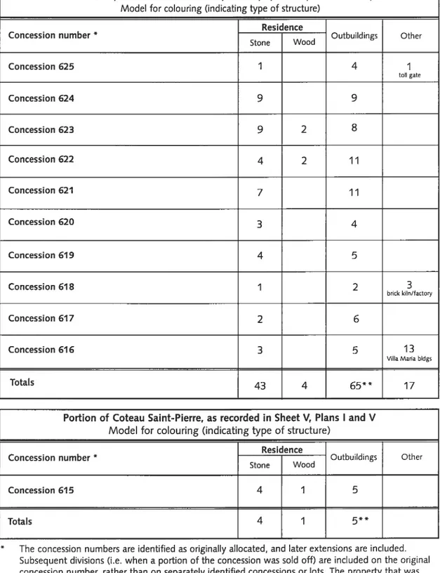
Table 5: Data from the Fortification Survey of 1871 69
Table 6: Ownership of Claxton (formerly Décatie) Residence,
5138 Côte Saint-Antoine 92
Table 7: Ownership of Ancestral Décatie Residence, fdemolished) 98
Table 8: Ownership of Fish (formerly Décatie) Residence, 39 Côte Saint-Antoine . . .112
Table 9: 1 $00 to 1874 — Known Extant Residences 117
1800 to 1874 — Known Demolished Residences
Introduction
1. Anonymous. Côte St-Antoine Road, drca 1900 2
Chapter One
2. H.W. Hopkins, detail, pages 102—103, Parish of Montreal, Atlas of the City and
lsland 0f Montreal,(. . .), 1879 9
3. Detail, Prairies au bas du Coteau St-Pierre, 1850 11
4. Detail, Terrier, lie de Montréal, 1834-5 12
5. Jean Péladeau, detail, Island ofMontreal, 1778 13
6. François Vachon de Belmont, detail, Description générale de l’isle de Montréal Divisée par costes où sont Exactement marquées toutes les distances de place en
place, les noms de chaque habitant, la quantité de terre qu’ils possèdent tant de front que de profondeur, les forts, Eglises et Moulins, le tout de suitte avec le
Meilleur Ordre que l’on a peu 15
7. Robert Harvie, detail, Église de Notre Dame de Toutes Grâces, 1893 17
8. François Vachon de Belmont, enlarged detail, Description générale de l’isle de Montréal Divisée par costes où sont Exactement marquées toutes les distances de place en place, les noms de chaque habitant, la quantité de terre qu’ils
possèdent tant de front que de profondeur, les forts, Eglises et Moulins, le tout
de suifte avec le Meilleur Ordre que l’on a peu, Robert de Villeneuve 12
9. Anonymous, detail, Villemarie dans l’isle de Montréal, 1685 20
10. Louis Charland, detail, Plan de la ville et cité de Montréal, 1801 21
11. H.S. Sitwell, Fortification Survey, 1871, SheetV, Plans I, Il, V and VI 22
12. Joseph Rielle, detail, Plan of Property belonging to Ephrem Hudon Junt situate
at Cote St. Antoine, Municipality of Notre Dame de Grace, (. . .), 1 874 23
13. Philip John Bainbrigge, Montreal from the Hill behind the Village of the
Tanneries on the Road to Lachine, 1840 24
14. Georges Delfosse, detail, view of Côte-Saint-Luc road, Dec. 1904 25
15. P. Morin, detail, Kawenote Teiontiakon. Published by H. Beaugrand,
director of La Patrie, in Le Vieux Montréal, 1677—7803 27
16. Anger, Jean-Baptiste, {UntitledJ, le 4 mai 1730 30
17. Detail, Map of the Harbour City and Environs of Montreal 33
18. H.W. Hopkins, detail of pages 102—1 03, Parish of Montreal, Atlas ofthe City
and Island0fMontreal, including the Counties 0fJacques Cartier and (. . .) . .34
19. Flooding, tramline to Lachine, date unknown 35
20. A. de Grandpré, detail, Topographi cal Map of the Mount-Royal, 1898 36 21. T.P.G. Shaw, The Glen, looking south toward Western Avenue bridge, 1889 . .37
22. Robert Harvie, Orchard in Coteau Saint-Pierre, circa 1890s 40
23. Robert Harvie, Farmer plowing in fields, 1893 42
24. Left: Robert Harvie, Décarie melon field, circa 1893
Right: B.T. Décarie delivery wagon, date unknown 43
25. Décarie orchard,1Le mouvement de l’immeuble et ses promoteurs Westmount
Annex, Jardins Décarie, Ave. Philipsville,” La Presse, Samedi,
le 2 décembre 1911, page 30 44
26. Left. Robert Harvie, Cornfield, circa 1890s.
Right: Robert Harvie, Harvesting, circa 1890s 45
28. H.S. Sitwell, Detail showing quarries north of the Côte Saint-Antoine Road,
Fortification Suriey, 1871, Sheet V, Plan II 4$
29. Décarie sand pits in the Glen. View south from Western Avenue, 1889 50 30. H.S. Sitwell, Detail, showing the Décarie brick fields and Glen Brickworks,
Fortification Survey, 1871, Sheet V, Plans Il and VI 51 31. Advertisement, reproduced from A Chronology of Montreal and of Canada
from A.D. 7752 to A.D. 1893 51
32. Janet MacKinnon, Land grants ceded by 1675 54
33. Janet MacKinnon, Land grants ceded by 1690 54
34. Janet MacKinnon, Land grants ceded by 170$ 55
35. Janet MacKinnon, Land grants ceded by 1713 55
36. Anonymous, Map of concessions Côte Saint-Antoine, after 1845 58 37. Beaupré Michaud architectes, Map of the transfer of the land plan on the
territory of the city of Westmount, 1988 60
3$. Marcel Trudel, Montréal, les terres de juin 7663, 1973 62
Chapter Iwo
39. Janet MacKinnon. Location of sellected dwellings f...) before 1874 70 40. Janet MacKinnon. Typical lSth-century farmstead layout 73 41. Michel Lessard and Cilles Vilandré. La maison au Québec de 1608 à 1900,
reproduced from La maison traditionelle au Québec, pages 66 — 67 74
42. Saint-Germain residence, circa 1885 77
43. J.C.S. Bennet, Saint-Germain residence, January 1897 78 44. H.S. Sitwell, detail, Saint-Germain residence, Fortification Survey, 1871 78 45. Left: Robert Harvie, Saint-Germain residence, drca 1893
Right: Mrs. T.P. Shaw, Saint-Germain residence, circa 1890 79 46. Robert Harvie, details (left and right), Saint-Germain residence, circa 1$90s . .80
47. Detail, view of lower Westmount before 1890, copied in 1913 by Wm.
Notman & Son 83
48. Claxton residence, circa 1930s, Claxton family album 86
49. Claxton residence, 1942 87
50. H.S. Sitwell. Detail, Fortification Survey, 1871 87
51. D. Lindsay, two views, Claxton residence, 5138 Côte Saint-Antoine, 1999 . . .88
52. Peter Lanken, Claxton House, measurements and sketch of plan for the
basement, main level and attic, April 25, 2003 89
53. Claxton residence, front façade, circa 1930s 90
54. Claxton residence, view of rear and side façades from Vendôme, circa 1930s .90 55. Alphonse E. Décarie residence, b/w postcard image, dated circa 1907-11 94 56. Alphonse E. Décarie residence, date and provenance unknown 96 57. H.S. Sitwell, Detail, Décarie farm, Fortification Survey, 1871, Sheet V,
Plan VI 96
58. Alphonse E. Décarie residence, view of front façade and Alphonse Décarie,
circa 1909 97
59. Hurtubise Residence, date unknown 100
60. H.S. Sitwell, detail, Hurtubise residence, Fortification Survey, 1871 100
61. Hurtubise Residence, circa 191 1—12 100
62. Hurtubise residence, circa 1900 102
64. Peter Lanken, Hurtubise residence, existing west elevation, April 1997 103 65. Phillips’ residence. Left: J.C.S. Bennet, December3l, 1896.
Rîght: photographer and date unknown 104
66. H.S. Sitwell, detail of site of PhiIIips’ (formerly Lambert Leduc) dwelling,
Fortification Survey, 1 $71 105
67. Doreen Lindsay, Fish residence, 1999 108
68. H.S. Sitwell, detail cf site of Décarie dwelling, Fortification Survey, 1871,
SheetV, Plan II 109
69. Detail, view cf Fish residence, 1892, photographer unknown 110 70. Joseph Rielle, detail, Plan of property belonging to William Angus, William
Notman, WJ.M. Jones, Ovide Dufresne, John Macfarlane and Alex Ramsay. Situate at Cote St. Antoine, Pari5h of Montreal, 1874 110 71. Charles E. Goad, detail showing Fish residence on lot 282-1 22, Atlas of the
CityofMontreal, Volume Il, Plate 70, 1890 110
Chapter Three
72. Advertisement, Vente Par Autorité de Justice” La Minerve, Vol. XXXI,
No. 57, February 17, 1859 116
73. Monklands, date unknown 123
74. H.S. Sitwell, detail, Fortification Survey, 1871, Sheet V, Plan I 123 75. George Heriot, detail, James Monk’s residence, 1817 124
76. Monklands, circa 1893 125
77. H. Macfarlane, detail, Rose Mount, situate on Cote St Antoine, near Montreal, subdivided into lots, the property of Asa Goodenough Es q., 1846 128 78. Detail, from streetscape cf Rosemount Avenue, circa 1872, copied for Miss
Reekie 130
79. H.S. Sitwell, detail cf Rose Mount property, Fortification Survey, 1871,
SheetV, Plan II 130
80. Notman & Sandham, north façade, Rose Mount, 1881 132 81. Notman & Sandham, south façade, Rose Mount, 1881 132 82. Terry Robinson, Measured Drawings, Rosemount House, Street Elevation,
January 1976 133
83. Ron Lawee, Front Elevation, Rosemount House, Sheet 6, January 1976 . . .133
84. Forden, circa 1910 135
85. H.S. Sitwell, detail of Forden property, Fortification Survey, 1871,
SheetV, Plan Il 135
86. Forden, drawing, 1844 136
87. Forden, date unknown 137
88. Forden, under demolition, 1948, reproduced from The Westmount Examiner,
Vol. XIX, No. 33, August 13, 1948 138
89. Stables, 50 Forden Crescent, circa 1979 139
90. Stables, 50 Forden Crescent, circa 1979 139
91. H.S. Sitwell, detail of Mount Pleasant property, Fortification Survey, 1871 . . .140
92. West Mount, detail, one view from a stereoscopic postcard 142 93. West Mount, detail, one view from a stereoscopic postcard 142 94. H.S. Sitwell, detail cf West Mount property, Fortification Survey, 1871 143
96. Simon Clarke Cottage, from OId Montreal, John Clarke: Hi5 Adventures,
Friends andFamiIy 146
97. H.S. Sitwell, detail of Clarke property, Fortification Survey, 1871,
SheetV, Plan II 146
98. Peter Lanken, Hypothetical reconstruction of front elevation, Simon Clarke
Cottage, January 2004 148
99. Detail, Côte Saint-Antoine Road looking west showing rooftops of the
Saint-Germain and Braeside cottages 150
100. H.S. Sitwell, detail showing location of Saint-Germain dwelling, Elm Cottage, and Braeside Cottage, Fortification Survey, 1871, Sheet V, Plan II 150 101. Robert Harvie, detail, view of plateau and Metcalfe Avenue, showing the
pavilion roof of Hays Cottage in foreground, 1892 151 102. H.S. Sitwell, detail showing Hays Cottage, Fortification Survey, 1871,
SheetV, Plan Il 151
103. Joseph Rielle, Plan of Property Belonging to Henry Lavender Esq. 5ituate aL
Cote St. Antoine, June 13 1874 152
104. Joseph Rielle, detail, Plan of Property Belonging to Henry Lavender Esq.
situate at Cote St. Antoine, June 13 1874 152
105. Detail, showing Clarevue and Braemarfrom streetscape of Rosemount
Avenue, circa 1872 153
106. ]oseph Rielle, detail, Map of the Montreal Mountain Boulevard, 1858 154 107. James Duncan, detail, Viewfrom theMountain, 1870 155
108. H. H. Macfarlane, detail, Plan of Upper Rosemount Showing the une of Boundar,’ Between the Proprietors John Eadie and William Footner Esquires,
April 29, 1848 156
109. H. H. Macfarlane, detail, Plan of Upper Rosemount Showing the une of
Boundary Between the Proprietors John Eadie and William Footner Esquires,
April 29, 1848 156
110. Hamilton Place, Paris, Ontario 157
111. Section, Hamilton Place, contemporary view, Paris, Ontarlo 15$ 112. Barott & Blackader Architects, Section, Residence for RA. Thomson Esq,
Westmount Blvd, Alterations and Additions, Drawing No. 133/5, 1924 158
113. Braemar, date and photographer unknown 159
114. Rosemount Avenue, circa 1906—7, colour postcard published by Valentine
& Sons, Co. Ltd 162
115. H.S. Sitwell, detail, Fortification Survey, 1871, Sheet V, Plan Il 163
116. Frederick N. Boxer, detail, Map ofthe City of Montreal: Shewing the
Victoria Bridge the mountain & proposed boulevard, 1859 163
117. AIme Gubbay, two views of extant dwellings of Metcalfe Terrace, 1978 . . . .164
118. Glenn Bydwell, Front Elevation during period of 1840—1857, 168 Côte Saint
Antoine, 1999 165
119. Glenn Bydwell, Front Elevation in 1999, 168 Côte Saint-Antoine, 1999 165 120. H.S. Sitwell, detail, Fortification Survey, 1871, Sheet V, Plan Il 166 121. McKenzie, N.H., Plan of partofFarm of M.]. Hays Esquire at Cote StAntoine
near the City of Montreal as divided into lots, February 21, 1855 166 122. Pierre McCann, Riverview, 513—515 Côte Saint-Antoine, circa 1992 167 123. H.S. Sitwell, detail of Riverview, Fortification Survey, 1871 167
124. Maison Isabella Nicol, 649 Côte Saint-Antoine 169
126. H.S. Sitwell, detail of Décarie farm, Fortification Survey, 1871
Sheet V, Plan I 170
127. W.S. Keith, Daniel Wilson House, circa 1900 172
128. H.S. Sitwell, detail of D. Wilson House, Fortification Survey, 1871 172 129. Robert Harvie, Harvie House, 355 Metcalfe Avenue, circa 1880s 174 130. H.S. Sitwell, detail of 355 Metcalfe, Fortification Survey, 1871,
SheetV, Plan II 174
131. Detail, Front Elevation, 355 Metcalfe Avenue, date and architect unknown. .175
132. Robert Harvie, Harvie House, circa 1890s 176
Cu rrency
During the period of 1675 and 1874, there were several types of currencies used in
New France, Lower Canada and Québec. The rates of exchange were adjusted throughout this period.
J livre français = 20 sols 1 sol = 12 derniers 1 louis d’or = 24 livres 1 écu = 20 shillings
1 pound sterling = 20 shillings 1 shilling = 12 pence
1765 — 1777
1 livre français = 0.9 livre tournois (currency of France) 1 livre français = 1 shilling (currency of Halifax)
1 Spanish dollar = 6 livres 1 Spanish dollar = 6 shillings
I pound (currency of Halifax) = 20 livres
1777—1857
1 livre français = 0.9 livre tournois (currency of France) 1 livre français = 1 shilling (currency of Halifax)
1 Spanish dollar = 6 livres
1 Spanish dollar 5 shillings (currency of Halifax) 1 Spanish dollar = 4 shillings 6 pence (sterling) J pound (sterling) = 24 livres
1857—
$1 .00 = 5 shillings
1 pound (currency of Halifax) = $4.00 1 pound (sterling) = $4.866
1 pound (sterling) = £1 4s. 4d.
From 1 871, the pound was no longer accepted for cash transactions.
Source: A.B. McCullough. La Monnaie et le change au Canada des premiers temps /usqu’à 7900, Ottawa (Ontario): Direction des lieux et des parcs historiques nationaux, Environnement Canada, Parcs, 1987.
Units of Weight
1 minot = 1.107 bushels (dry grains) = 39 litres 1 pipe = 105 galIons = 477 litres = 2 hogshead = 3 tierces Units of Measure
1 French foot = 0.32484 metres = 1 .06575 English feet
(superficial) = 0.1055 square mettes
1 arpent (linear) 180 French feet
= 191.835 English feet
58.4713 metres 10 perches/rods
= 30 toises
1 arpent (superficial) = 32,400 square French feet
0.3419 hectares
= 0.8448 actes
1 perche = 18 French feet
J toise = 6 French feet
1 verge = 0.91 44 metres
J English foot = 0.3048 metres
1 lieue = 24 arpents
=15,120 French feet
= 4,911 .59 mettes = 16,114.14 English feet = 3.05 miles
1 metre = 3.0784 French feet
=3.2808 English feet 1 acte = 0.4047 hectares
Source: Conversion des unités de mesure de longeur et de superficie, Bureau de l’arpenteur général, Ministère des Ressources naturelles; http://arpentage.mrn.gouv.qc.ca/conversion/
ANQ Archives nationales du Québec
ASSSM Archives du Séminaire de Saint-Sulpice de Montréal
AVM Archives de la Ville de Montréal
BNQ Bibliothèque nationale du Québec
CCA Canadian Centre for Architecture
CHQ Canadian Heritage cf Quebec
CPR Canadian Pacific Railway
MJ-BPD Ministère de Justice, Bureau de la publicité des droits
NPA-MMCH Notman Photographïc Archives, McCord Museum cf Canadian History
PAC Public Archives cf Canada
STM Société de transport de Montréal
VM Ville de Montréal
In an effort to reduce confusion, one speliing has been selected for each famiiy name incIuded in the study. Historicalty, there have been many different speHings found in the various officiai records and documents. For instance, in the Aveu et dénombrement of 1731 and 1781, the names of members of the same famiiy (i.e., children and brothers) are recorded with different spellings (refer to tables 3 and 4). Whiie the majority of the early habitant selliers were illiterate and could not write their names, this was not the reason for the variety. lnstead, it was common for record keepers to speil famiiy names phoneticaily and lifrie allention was paid to a detaii such as consistent spelling. This is not a pecuIiarity to New France or Lower Canada, as t occurred in the countries of origin as weil. Indeed, it is a frequent idiosyncrasy occurring with genealogicai study.
The phenomenon was not exclusive to the l7th and l8th century; it occurs with the speiling of the l9th-century residents of Côte Saint-Antoine as weii. For instance, aIthough John Ogilvy signed his family name with a y,” the speHing in several notarial contracts is ‘Ogiivie.” (For example, refer to an agreement to buiid a fence around his property, dated December 29, 1814, and notarized by J.-D. Desautels). Ogiivy was a hterate man, and although one may assume he read the contract, he evidentiy did not request corrections to the spelling.
Uniess appearing in a quotation or otherwise noted, the speiiings seiected for this thesis are consistent with contemporary usage. For instance, the Décarie name s speiied in the same manner as the boulevard and expressway are today. The same is true for Prud’homme. When no common contemporary usage has been found for the habitant’s names, the spellings follow the usage in the Dictionnaire généalogique de5 familles du Québec à 7730, by René Jetté et al. For the famiiy names recorded in later periods and not inciuded in the Dictionnaire généalogique, the most frequently used speiiing has been selected.
It s a curious notion that given the relativeiy short duration since the founding of Ville-Marie in 1642 that so much stili needs to be documented for the collective history of the development of the town and communities that formed and evoived into the metropolis that we know today. There remain many communities, including the island’s côtes, that have neyer been studied at ail. What awaits investigation are the histories of the early settlers and builders, the framework that fostered the land settiement and the patterns that evolved, the agricultural land use and the development of a rich architectural Iegacy found in the local dweliings, both extant and demolished. Whiie the landscape today provides ample traces of that history, the documentary evidence lies buried in archivai records. This is the case for Côte Saint-Antoine.
Through a study of the landscape and built environment — in particular the rural
domestic architecture — this thesis wilI establish what existed in Côte Saint-Antoine
between 1675 to 1874. It will investigate how and why the area was settled, by whom and when. The landscape will be examined, revealing that it supported a fine agricultural industry and was a good source of building supplies — the wood, stone and sand
necessary for constructing the local dwellings and farm buildings. What was built in the area will be examined over the 200-year period. By combining these elements, this study serves to reconstruct a picture of Côte Saint-Antoine from its humble roots until the creation of the first village and end of its solely rural composition.
Ihe area of Côte Saint-Antoine was seiected in large part because along with the
other inland côtes on the island it has not been academically studied. While this thesis will examine Côte Saint-Antoine in particular, the findings will be of relevance in a broader sense to the study of other côtes. As they were created as integral parts of a larger network of roads and associated communities, their histories are often intertwined. This is seen to a greater extent for the neighbouring côtes, where residents expanded or exchanged their landhoidings from one côte to another. The system of granting land was consistent across the island, thus understanding the process for one côte is applicable to alt. lnvestigating the rural domestic architecture of Côte Saint-Antoine is also relevant to a beffer understanding of the types of rural dwellings specific to the island of Montreal. The study of Côte Saint-Antoines domestic architecture begins in the early 1700s. It comprises the evolution of a local vernacular, the fieldstone farmhouse, in addition to the other dwellings types, inciuding the villas, summer cottages and detached, single-family dwellings. Many fine examples are extant of the domestic architecture built from the 1730s onward. lt is one of the few areas on the island of Montréal that contains examples of dwellings from different periods of its development.
Figure I
Anonymous. Côte Saint-Antoine Road, circa 1900, Archives of the Westmount Historical Association.
lndeed, Côte Saint-Antoine makes a good area for study because it remains relatively welI preserved. Although it is no longer a rural community, the territory was neyer vigorously appropriated by commercial development. The commercial downtown stopped largely at its border, allowing Côte Saint-Antoine to retain much of its residential character. Côte Saint-Antoine Road remains both physically and in name, and the area is fortunate to boast many fine extant dwellings built throughout the study period. Thus, while no longer a rural community, there remain many tangible traces from its rural past that aid in researching its history.
Knowledge of this past is vital to the ongoing preservation of both the area as a whole and the individual historic buildings within it. While this study does not focus on the preservation aspects of the area and buildings per se, it may be used as a tool for that end by furnishing the historic context and establishing the manner in which the domestic architecture was built and endured. It enables the building owners, the community-at large, the borough and municipal councils to better appreciate the heritage value of the architectural legacy under their care. Without such an understanding, it is difficult to legislate the protection of the heritage resources by means of by-laws, building and planning guidelines, and heritage recognition at the municipal, provincial and federal levels of government. In general terms, understanding the history of one’s community and property fosters a sense of collective and individual pride that s a vital ingredient in the safeguarding of heritage resources. With time, this appreciation becomes an intrinsic value. lndeed, this study reveals that of the extant dwellings in the study area, ail are well maintained and their owners are aware of their architectural and historic importance.
As one of the island’s smaller iniand côtes, Côte Saint-Antoine’s size permits its close examination. Originally just thirteen farms were created along the côte road, making it possible to delve into the land grants, tities and subsequent transactions. Tracing who owned the farms facilitates the research into what was built. The latter is not possible without first understanding who settled in the area, for the majority of the data concerning the rural domestic architecture is documented in the construction contracts (logged by name, not territory), the post-mortem inventories and wills of the proprietors. With regard to the architectural history and analysis, investigation concentrated on providing consistent basic details for the selected dwellings. Given the scope of the study, and the nature of the research required, the investigation focused first on determining what had been constructed in Côte Saint-Antoine, and secondly, on its architectural analysis. At a minimum these findings comprised evidence of the dweiling’s existence and location, an approximate date of construction and demolition, a general description and history, and if fortunate, architectural drawings and period imagery. The study individually examined twenty-two dwellings: six built during the period prior to 1731; five built between 1731 to 1800; and eleven built between 1800 to 1874. Given the number and variety of dwellings, an in-depth analysis was not possible for each one. Certain cases demanded more detailed study, and this was undertaken with the knowiedge that further research work is stili necessary. In ail cases, even the dwellings for which individual studies were commissioned in recent years, detailed architecturai studies would greatiy further our understanding and appreciation.
The exterior of the buildings and their structure were examined to the exclusion of the interiors. While the buildings’ interiors are an equally important component to any architectural analysis, the choice to exciude them was made for several reasons. Primarily, the scope of the study did not permit in-depth investigation of the interiors (brief descriptions are included from time to time). Given the number of dwellings, this would have been too large a task to undertake. Because this study s interested in the genesis of the côte and the construction of the dwellings in the broader sense, analysis of the interiors was not vital to the study. Another factor, although not in and of itself prohibitive, is that the dwellings are private residences. Given the number of extant dwellings examined, t would have been a long process to ensure that a consistent methodology was in place for this type of study, and one that would require the co operation of the proprietors. Keeping the study to the structurai elements and exteriors, meant that the proprietors did not necessarily have to become an integral part of the process. As many of the dwellings have been demoiished, it also meant that a similar
treatment was unîformly applied ta ail dwellings — site visits could not have been made
for the demolished dwellings and information regarding the interiors of the pre-1800 dweliings is non-existent.
This being said, site visits were made to ail the extant dweilings in the study, with interior tours included for the majority of them. In many cases, this was vital to evaluating the architectural evolution of the buildings.
The period of study, 1675 to 1874, was defined by the date of the purchase of a strip of farmiand, concession 615, by Jean Décatie dit Lehoux. It was this purchase that initiated the sefflement of what was to become Côte Saint-Antoine. The Décarie farm was soon extended northward within the study area and others followed closely thereaffer. The study period ends with the creation of the Village de Notre-Dame de Grâce in 1874, defining the end of its solely rural tradition.
Structurally, the thesis has been divided into three chapters. The first explores the manner in which Côte Saint-Antoine came into existence, its general history and development, and the manner in which the land was used for agricultural and building purposes. Through an investigation of the concessions, the thesis examines the pafferns of seUlement and building. The second and third chapters examine the rural domestic architecture from 1675 until 1800, and from 1800 until 1874, respectively. The appendices provide the following: a table summarizing the history of the land grants and transactions for each concession, a list of notarial contracts consulted, transcriptions of selected contracts, and selected genealogies of the habitantselliers.
In terms of methodology, this thesis was based largely on primary research. 0f the variety of data sources, the most valuable were the notarial contracts located at the Archives nationales du Québec. The research entailed the location and analysis of the notarized documents, including the land grants and sales, land exchanges, deeds, leases, wills, post-mortem inventories, construction contracts, building supply contracts, and other legal or court documents, such as minutes, commutations, awards and judgements. Parochial records, such as birth, death and marnage certificates, were cf importance to some of the analysis. The notarial contracts were located by means of the Parchemin1
index, which contains a listing and brief summary of the contracts of the period of 1635
1. Archiv-Histo. Parchemin; banque de données notariales (1635—1 775). This s available on CD-rom at the Archives nationales du Québec, Montréal.
to 1775. Affer that period, location of the notarial contracts is primariiy by means of the indexes and records of the individual notaries.2
The Sulpicians’ Livre terrier de la Seigneurie de l’Île de Montréal,
À
l’exception dela ville, de5 faubourgs et des villages,3 a land register and plan of the island detailing Côte Saint-Antoine and Coteau St-Pierre, among other communities, proved to be the single most important document from which the reconstruction of the land divisions, grants and title successions were based. Whiie the Livre terrier does not cover the entire study period
— the early entries are not aiways complete or precise and the document ends with the
commutation of the properties — this study would not have been possible without if.
Another important source are the Aveu et dénombrement4 taken in 1731 and again 1781. These were officiai accounts of proprietors’ land holdings, noting for instance whether they had a stone or wood house, barns and stables, and the status of cultivated land. These are extremely useful both for confirming the Livre terrier and to use as an additional base for study, providing the earliest source material for the land use.
The study period encompasses a time frame of almost two hundred years, a context too large for an exhaustive investigation of its land development and architecture. For the l7th and l8th centuries, the large number of notarial contracts and deeds were almost exclusively the sole wriften data sources. However, given not oniy the time restraints of the study, but aiso in practical terms, it was not possible to locate and conclusively analyze ail the land transactions. As a resuit, there remains work to be done to clarify the succession of some of the land titles. Fortunately, the majority of the concessions remained within the same families from the early and mid 1700s until the 1800s, thus the general lineage of the successions during this period s weli documented through this study.
2. Work is ongoing at the present time to further the Parchemin index to include the period from 1775 into the 1800s (the final date 15 not yet established). I am grateful to Monsieur Normand Robert for providing my access to the ‘version brouillon”of the index. I also wish to achknowledge the supportive assistance of Madame Esteile Brisson at the Archives nationales du Québec, who permitted me to work from the original indexes and records of the notaries who worked during this period, rather than from the microfiimed documents.
3. Livre terrier de la Seigneurie de l’Île de Montréal, À l’exception de la ville, des faubourgs et
des villages, Volume Il: Comprenant le N°504, et les suivantes, jusqu’à N°983, pages 106—121.
4. For 1731: Roy, Antoine. ‘Le recensement des gouvernements de Montréal et des
Trois-Rivières,” Rapport de l’archiviste de la Province du Québec (RAPQ) 1941 -2. For 1781: Perrault, Claude. “Declaration du fief et seigneurie de L’isie de Montréal Au papier terrier du Domaine De Sa Majesté En La Province de Québec en Canada, Faite le3 février 1781 parJean Brassier, p.s.s.,”
Other source material comprises vital trace evidence — extant buildings and sites —
maps, plans and drawings, and period photographs. These documents are important primary sources. It should be noted that while much of the period photography dates to the latter 1 800s and turn of the century, t records much of the earlier development and dwellings, and is extremely valuable in interpreting the textual descriptions.
0f the secondary sources, a wide variety of documentation exists to draw from. There are a number of useful unpublished commissioned studies. A large study was completed in 1989 by Beaupré Michaud architectes for the City of Westmount. Entitled
Westmount: analy5e du patrimoine immobilier, it provides a history, general survey and heritage evaluation of extant dwellings. This document provides minimal detail of Côte Saint-Antoin&s history and domestic architecture and is better used as a broad overview. In recent years, a small number of professional studies were commissioned for four of the extant dwellings, including the Hurtubise house, Braemar, Wardleworth house (Metcalfe Terrace) and Rose Mount. These studies have been very useful to this thesis.
Another excellent unpublished source are several Master-level theses. While there s not a thesis on a topic directly involving Côte Saint-Antoine, there are number that concern related topics and thus they are helpful to understanding the general history, development, agriculture, and architecture of the côte.
Prior to the 1 800s —with few exceptions—the residents of Côte Saint-Antoine were
mostly illiterate and thus there are no written accounts specific to the area for the early centuries. Personal documentation, including diaries, letters, autobiographies and written accounts from the 1800s onward, was invaluable in piecing together the histories of individual dwellings. While this material is located in various institutional collections, family descendants and building proprietors also produced valuable personal documentation from their private collections.
With the influx of new residents, travellers and publications in the 1800s, secondary source material is more readily available. However, caution is necessary regarding the accuracy of some of the published historical accounts of Côte Saint-Antoine, which are scant in detail and at times tempered by myth. The desire of some authors and property owners to daim the oldest, largest or finest residence has resulted in the attribution of incorrect construction dates and interpretations of architectural features, and has prompted assumptions of fact.
0f the recently published histories concerning the area, ail concentrate on the formation and ‘story” of Westmount. These have been written by amateur historians, and are popular, rather than academic histories. To date, there s not a published
reference providing a reliable history of the côte’s settlement and development. Within the published histories of Westmount, including Westmount: A View of their Own, by Aime Gubbay, OId Westmount, by the Old Westmount Club with Dr. Hélène SaIy as advisor, and We5tmount: A Heritage to Preserve, by Louise A. Legault, there are very brief references to Côte Saint-Antoine only. The same hoids true for material on the neighbouring district of Notre-Dame-de-Grâce.
Ail this source material, both primary and secondary, serves to both provide the dues and at times, confound the researcher. There is such a vast amount of archived material yet to be investigated that one couid most certainly continue this study, expanding the findings and resoiving unanswered questions. Whiie every effort has been made ta avoid conjecture and misinterpretation, I take full responsibility for errors made on my behaif.
At the very Ieast, it is hoped that this thesis accompiishes the following overal) objectives: that it responds to the need for academic research into the built environment of Côte Saint-Antoine; contributes ta an understanding of the development of one cf the island’s inland côtes; provides its readers with sufficient tools to undertake any further research work; and lastly, establishes a broad geographical and historical context useful to the development of preservation strategies for the community and built environment.
1.1 Defining the geographic boundaries of the study: from plateau to mountain
The area of study encompasses what was known as Côte Saint-Antoine1 in its early rural history. A narrow strip of land at the eastern end of neighbouring Coteau Saint-Pierre is also included. Today, the corresponding area rests largely in the Borough cf Westmount, with a portion in the District of Notre-Dame-de-Grâce.
Côte Saint-Antoine Road runs through the centre of the study area. This road, which survived physically intact as well as in name, is one of the island’s original côte roads. t was created around the turn of the l7th century by the Sulpicians as part of a network of access routes that facilitated land settlement across the interior of the island of Montréal. Although two concessions at the western end of Côte Saint-Antoine Road were considered part of Coteau Saint-Pierre, they have been included sa that the full length of the côte road can be studied.2 These additional concessions are important for another reason. They belonged to the Décarie family; one purchased by Jean Décarie dit Lehoux in 1675, and the other ceded through a land grant. The Décarie family played a primary role in the development of area.
Today, the study area is bound by the following streets: to the east, Wood Avenue; to the west, Décarie Boulevard; and ta the south, Saint-Jacques Street. Ta the north, the area roughly corresponds ta the borough limits of Westmount.
The boundary limits for the study have been indicated with a red line on H.W. Hopkin’s 1879 map of the Parish of Montréal (figure 2). As discernible on Hopkin’s map, the boundary limits for Notre-Dame-de-Grâce (today Westmount), indicated by a dofted me, caver the territory of the study area, with as noted, the addition of the two Décarie properties west of the boundary line at the western end 0f the côte road. This map was
surveyed at a time when the area still maintained much of its rural land use, but was in a transitional stage with some development of the current street plan already under way. Thus it s possible ta gain a clear understanding cf the area under study with the knowledge of today’s street plan.
1. The area is no longer identified as Côte Saint-Antoine. Prier to its current name, the area had several names throughout its history. lndeed, the territory was first referred to as the quartier (or cartier) Saint-Joseph in the 1600s. Refer te Section 1.3 for a more complete history of the toponomy.
2. The road when first constructed wasan extension of Coste Samnt-Joseph. Sections of the côte road were renamed te coincide with the major directional turns of its path. This study will include only the western section of the road, the portion that came to be called Côte Saint-Antoine.
Figure 2
H.W. Hopkins, detail of pages 102—103, Parish of Montreal, Atlas ofthe City and IsIand of Montreal, including the Counties 0f Jacques Cartier and Hochelaga, s.L. [absence of location]: Provincial Surveying and Publishing Company,1879, McGill University, Rare Books and Special Collections.
The area selected may not appear by today’s map to be logically defined, either in geographic or municipal terms. Yet historically, the manner in which the area was developed may be attributed to two main factors. Firstly, the exchange and extension of the concessions from the neighbouring Coteau Saint-Pierre and Côte Saint-Joseph. The latter resulted from northerly deveiopment from the Faubourg Saint-Joseph — within the
vaguely defined Contrée Saint-]oseph3 — the first suburb developed outside the
fortification walls. Its southern limit was the Petite rivière. Secondly, the creation of the network of côte roads laid out by the Sulpician seigneurs ot the island. Both were affected by distinguishing geographic features specific to the area. These contributing factors wiii be discussed in greater detail fufther on.
The area of study was bordered to the south by the small rivière Saint-Pierre. This river, in parts nothing more than a creek or stream, ran almost parallel to the escarpment before veering south en route to Verdun. The land concessions were granted from the rivière Saint-Pierre northward to the plateau and mount above the escarpment. Thus, when considering the concession boundaries of Côte Saint-Antoine and Coteau Saint Pierre, the eariy land grants ail started at the river,4 in what 15 today the District of Saint Henri. The map of the concessions granted in Coteau Saint-Pierre (figure 3) indicates the pattern in which the land was divided into long strips starting at the rivière Saint-Pierre. Although the escarpment would have made a natural dividing une between the properties, one must keep in mmd that earlier concessions had been granted south of the rivière Saint-Pierre, using the river as a northern limit. Many of the habitants that were granted land in the western portion of Côte Saint-Antoine and throughout Coteau Saint Pierre, previously held concessions either south of the rivière Saint-Pierre or on land a little fufther east in the Faubourg Saint-Joseph where the river shifted south crossing through their properties. In some cases, the concessionaires were granted the land in
3. Massicotte, Édouard-Zotique. Les Familles Descary, Descarries, Décary et Décatie, ‘1650 —
7909, Montréal (Québec): Aiphonse Décary, 1910, page 8.
4. ANQ, contract of land sale, Basset, B., 03 06 1675. By way of example, the second
concession granted to an habitant in the area was to Simon Guillory. This concession was purchased by Claude Raimbault and subsequently sold to Jean Décarie dit Lehoux in 1675. The
contract of sale locates the concession as follows; ‘Une concession de quatre Vingt arpens de
terre, Scize et Scituée en laditte isle, au lieu dit la riviere S pierre commenceant d’Un bout Sur une ligne données des concessions deladte Riviere St pierre, quatre arpens de large, Sur Vingt arpens de profondeur, tirant au Nord ouest quart d’ouest, t The contract s provided, fully transcribed, in appendix 1.
compensation for the flooding that occurred every year, causing damage to their fields.5 The fief Saint-Augustin, bordered also to the south by the rivière Saint-Pierre, will not be included in the study area. The fief forms the southern border of the concessions numbering from 618 to 625, corresponding today to Ste-Catherine Street.
To the north, the study area extends from the plateau above the escarpment and beyond the Westmount peak of Mount Royal to its gentle northern slope. In historic terms, the property lines reached as far north as the concessions of Côte-des-Neiges and Côte Saint-Luc, which ran across the back end of Côte Saint-Antoine along the path of today’s Queen Mary Road.
The eastern and western boundaries of the study area are more readily defined by streets than by geographic features. Today, the eastern boundary is Wood Avenue, where a corresponding concession bore the description, “porté de la Côte Saint Antoine.”6 in 5. ANQ, accord between the seigneurs and Honoré Dasny dit Latourangeau; brothers Paul, Michel and Louis Décarie; Lambert, Jean and Joseph Leduc; and Raphael Beauvais, Adhémar, A., 20 03 1690. This contract details the agreement to replace flooded land near the rivière Saint Pierre. Alan Stewart notes in his 2001 report, Étude patrimoniale de la maison des Hurtubise, that there were several references in previous contracts dating to 1688 for the land exchange because of the flooding, page 17, notes 18— 20.
6. AVM, Livre terrier de la Seigneurie de l’Île de Montréal, page 118. The reference to the “porté à la Côte St Antoine” is found listed beneath an entry for a small piece of land sold at the front of concession 624, concerning one of the earlyhabitants, Bernard Maurice dit Lafantasie (a contemporary of the first concessionaires in Côte Saint-Antoine), who acquired land there.
Figure 3
Detail, Prairies au bas du Coteau St-Pierre, 1850 (with additional notations dating to 1854), Archives des Prêtres de Saint-Sulpice, Montréal, Ref #: alphanumérique 1323. (This map has been turned 180° to faciliate the reading of titles and descriptions).
the Livre terrier. The Livre terrier, a land register and corresponding plan of the concessions granted in the Montréal suburbs, was prepared by the island’s seigneurs, the Prêtres de Saint-Sulpice. While Wood Avenue corresponds to what once was the eastern boundary of the côtes first concession, 625, it was not the location of Côte Saint-Antoine Road. The road ran between the first and second concession along the path of today’s Greene Avenue. Figure 4, a map entitled, Terrier, lie de Montréal, dating to 1834-5, clearly indicates the path of the côte road running between concession 624 and 625.
From the point of present-day Greene Avenue, the côte road turned sharply northwest up a gentie incline across the slope of the western summit of Mount Royal. This is the section that bears the name of Côte Saint-Antoine to this day. The côte road originally ended where today’s Décarie Boulevard is located, making the latter the logical western boundary of the study area. This large urban thoroughfare extends the full length of the western limit of the area. The boulevard and the trench” of the adjacent Décarie Expressway form a formidable dividing line between two sectors of the city. Historically, the boulevard marks the path of the chemin de la Côte Saint-Luc that ran northward along the Décarie propefty line, and which provided a link between the other
Figure 4
Anonymous, detail, Terrier, lie de Montréal, 1834-5, Archives de la Ville de Montréal, Numéro 2708, cadres 85.
côte roads further to the west. Accessed by the chemin de Lachine en haut was Coteau-Saint-Pierre ta the southwest, and Côte Saint-Luc was found ta the narthwest.
Initially, Côte Saint-Antaine was linked anly ta Côte Saint-Luc, and it was nat until the late 1700s that a link was alsa made with Cateau Saint-Pierre. On the map surveyed by Jean Péladeau in 1772 (figure 5), a datted une indicates a planned southern extensian af the chemin de la Côte Saint-Luc ta link Côte Saint-Antaine with the chemin de Lachine en haut. It is passible ta trace the path af the chemin de la Côte Saint-Luc narthward alang the western baundary af Côte Saint-Antaine and turning eastward ta cannect with Côte-des-Neiges. Péladeau’s map alsa indicates a planned extensian af the chemin de la Côte Saint-Luc ta meet the end af the Décarie praperty unes, and with a prapased straightening af the raad alang its east-west length. These plans were carried aut as indicated by Hopkin’s later map af Notre-Dame-de-Grâce (figure 2). The prapased changes of 1778 are the start 0f a regular grid plan later imposed an the area af Côte
Saint-Antoine. Until that paint, the roads ambled thraugh the countryside fallowing the natural landscape.
Rgure 5
Jean Péladeau, surveyar, detail, Island 0f Montreal, 1778, Department af Public Warks, Baraugh of Westmaunt.
1.2 Network of côte roads and chemin de Lachine en haut
Prior to the development cf the network cf côte roads, access across the island of Montreal was limited. From the various defense posts located strategically around the island, a rim road permitted travel along the river’s edge between the few scattered forts, trading posts and Ville-Marie. This road did not completely encircle the island, but importantly linked the smali settiements by way cf land, improving the access to areas previously only reached by river. Thus, to encourage and facilitate further settlement, in the spring of 1698, François Dollier de Casson, Sulpician superior, requested Gédéon de Catalogne, the king’s engineer, te lay eut “côtes” for the inland areas cf the island.7 The resulting côtes divided portions cf the island into sections much like neighbourhoods, or
arrondissements. These were further divided into concessions destined for individual settieme nt.
The côte roads followed the general topography cf the island, gradually rising alongside hiilsides, running next to streams or traversing the plains. Historian Louise Dechêne notes that each côte was different, corresponding to its own particular landscape.8 The earliest known cartographic reference to the côtes is found on a map
dating to 1702 (figure 6) entitled, Description générale de l’isle de Montréal Divisée par costes où sont Exactement marquées toutes les distances de place en place, les noms de chaque habitant, la quantité de terre qu’ils possèdent tant de front que de profondeur, les forts, Eglises et Moulins, le tout de suifte avec le Meilleur Ordre que l’on a peu. In studying the map, it appears that the earliest côtes were concentrated mainly around Mount Royal and on the plains to the north, effectively positioning the two summits cf the mountain as a funneling point along an axis linking the new settlements, by way of Coste Notre Dame des Neiges, with Ville-Marie. The placement cf the côtes seems almost random with most concessions facing north to south, some east to west, and a few on the diagonal. However, as Dechêne notes, key factors such as streams, valleys and
meadowland, affected the manner in which the land was sectioned.
Once the first côtes were settled, adjacent ones were created, and in such a manner, the land settiement leap-frogged its way across the island. Jean-Claude Robert notes that
7. Marsan, Jean-Claude. Montréal en évolution : Historique du développement de l’architecture
et de l’environnement urbain montréalais, Montréal (Québec): Éditions du Méridien, 1994, pg. 55. 8. Dechêne, Louise. Habitants et marchands de Montréal au XVIl siècle, Montréal (Québec): Librarie Pion, 1974, pages 259—260.
Figure 6
François Vachon de Belmont, detail, Description générale de l’isle de Montréal Divisée par costes où sont Exactement marquées toutes les distances de place en place, les noms de chaque habitant, la quantité de terre qu’ils possèdent tant de front que de profondeur, les forts, Eglises et Moulins, le tout de suitte avec le Meilleur Ordre que l’on
the côtes were created as needed, and that by 1731, thirty côtes were in existence.9
Jean-Claude Marsan clarifies the common understanding of the côte roads as follows: La côte a joué un rôle primordial dans la formation des paysages et de l’environnement urbains montréalais, ainsi que dans la genèse spatio temporelle de la grille de rues orthogonale. Peu de chercheurs se sont véritablement intéressés à cette réalité et la signification première de la côte semble aujourd’hui partiellement perdue. Trop souvent, elle n’est assimilée qu’à des chemins ou des routes et comme certaines de ces voies, tel le chemin de la Côte-des-Neiges ou celui de la Côte-Sainte-Catherine, sont remarquables pour leur forte dénivellation, on présume que le mot côte reste synonyme de route en pente, selon le sens attesté par le Larousse et le Robert! Mais la côte montréalaise, ainsi que la côte québécoise, est complètement étrangère à l’idée d’une différence de niveau. Car des territoires aussi plats et unis que celui de la Côte-de-Liesse ou de la Côte-Vertu étaient, originellement, des côtes, au même titre que celles de Notre-Dame-des-Neiges ou de Sainte-Catherine. La Côte s’apparente avant tout à une unité territoriale organique définie, et pourrait être synonyme d’« unité de voisinage » f. .
This description certainly applies to Côte Saint-Antoine Road, which rises diagonally across the terraced slope of the Westmount summit into Notre-Dame-de-Grâce. There t links with the chemin de la Côte Saint-Luc, which traverses the plains to the west.
As suggested by ]ean-Claude Marsan, the côtes became a social entity,11 where the inhabitants identified with their immediate neighbours and terrain. Marsan notes that while the côtes formed the basic unit of territorial organization, the parish, which usually encompassed several côtes, formed the basic unit of civic and social organization.12
Distances in the 1700s by comparison to today were much greater, as travel by horse or horse-drawn carnages and sleighs was slow and laborious. Thus by necessity, in the côtes further from Ville-Marie, the early concession contracts required the construction of neighbourhood churches. For Côte Saint-Antoine this was not the case. Prior to the construction of a local church, the residents of Côte Saint-Antoine would have to travel into Ville-Marie to the Église Notre-Dame at Place d’Armes. Later they could frequent the Village de Saint-Henri-des-Tanneries where, according to Alan Stewart, a chapel was built
9. Robert, Jean-Claude. Atlas historiques de Montréal, Montréal (Québec): Art Global inc., Éditions Libre Expression, 1994, page 43.
10. Marsan, Jean-Claude. Montréal en évolution, page 51. 11. lbid, page 51.
after 1815.13 In 1849, thirty acres were purchased on the Prud’homme farm, concessions 613 and 614, to erect a church, Église de Notre Dame de Toutes Grâ.ces.14 Renowned architect John OsteIl was contracted by Monseigneur Ignace Bourget to undertake the design. It was built near the junction of Côte Saint-Luc and Côte Saint-Antoine roads and opened on September 18, 1853.15 t was there that a village was eventually established. Côte Saint-Antoine was unified in part by the small number of farms within the côte and the families’ need to work together to develop their concessions. That there was considerable intermarriage between the residents16 is a testament to the strong community connections and the territorial boundaries of their everyday ives.
From an enlarged detail of the map of 1702 (figure 8), it appears that there were only two côtes created in the vicinity of the mountain. Coste Saint-Joseph was accessed by a road that tan northwest from the western gate of Ville-Marie and traversed the
13. Stewart, Alan. Étude patrimoniale de la maison des Hudubise, page 14.
14. AVM, Livre terrier de la Seigneurie de l’Île de Montréal, pages 106. An historical account is
provided in: Collard, Edgar Andrew. 0f Many Things ... How N.D.G. got its name,” The
Gazette, September 25, 1982, page B-2.
15. Le Cinquantenaire de Notre Dame de Grâce,” La Patrie,August 29, 1903, page 1. 16. Refer to the family genealogies, Appendix IV.
Figure 7
Robert Harvie, photographer, detail, view of the Église de Notre Dame de Toutes Grâces, 1893, Archives ofthe Westmount Historical Association.
south side of Mount Royal. Its concessions encompassed the central core of today’s downtown, from the boundary of Coste Saint-Louis at Beaver Hall Hill and its extension, Aylmer Street,17 to present-day Westmount. The chemin de la Coste Saint-Joseph ran along the path of today’s boulevard René-Lévesque and Dorchester, and provided access to the fort of the Domaine de la Montagne and the nearby farm (fiefs) of the Hôtel-Dieu. The chemin de la Coste Notre Dame des Neiges, later simplified to Côte-des-Neiges, ran north from the foot of Mount Royal up between its two peaks, and then branched into two sections, one continued northward and the other turned west behind the western summit of Mount Royal.
t is certain that the name of Côte Saint-Antoine was not yet in use in 1702. The côte road was an extension of the chemin de la Coste Saint-Joseph. For the first years, Côte Saint-Antoine was identified by the name of Coste Saint-ioseph. No documentation has been found that aftests to the côte road’s construction date, and the Description générale de I’îsle de Montréal does not provide any concrete dues. t is noteworthy that
neither the extension that later became Côte Saint-Antoine, nor Côte Saint-Luc are on
the map of 1702. Furthermore, neither of these côtes, nor Coste Saint-ioseph (although present on the map), are noted in the following description written on the map:
17. Stewaft, Alan. Settiing an 78th-Century Faubourg: Propedy and Family in the Saint-Laurent Suburb, 7735 — 7870, May 1988, page 4. The boundaries of Côte Saint-Louis (later the faubourg Saint-Laurent) are clearly defined by Alan Stewart in his thesis.
Figure 8
François Vachon de Belmont, enlarged detail, Description générale de l’isle de Montréal Divisée par costes (. . .), Bibliothèque de la Compagnie de Saint-Sulpice, Paris, MS 1198.
“Au bout desquelles susd. terres depuis le fief de l’hopital jusques à St. Michel et le Domaine de la Montagne derrière laquelle sont les Costes N. Dame des Neiges Ste. Catherine et St. Laurent nouvellement et bien habités Et les costes N. Dame de Liesse et des Vertus qui ne sont pas encore habitées. Après St. Michel suit gadois et derrière la ville.”18
In addition, the limits of the côte as drawn appear to stop at the area where the chemin de la Coste Saint-Joseph was to be extended (starting at today’s Dorchester) and Côte Saint-Antoine created. However, as the map is a loose schematic drawing and not an accurate rendering, it s not a trustworthy tool in defining the exact boundaries and location of the first côtes. 0f more use is the listing of inhabitants of the various côtes provided at the bottom half of the map. Both Coteau Saint-Pierre and Coste Saint-Joseph are described in full detail. There is no mention of any concessions in the portion of Coste Saint-Joseph that later became Côte Saint-Antoine, with the exception of the farmland ceded in 1650 to Jeanne Mance and the Hôtel-Dieu. Called the fief Saint-Augustin, and commonly referred to as “la grange des pauvres,” or “les pauvres” on early documents and maps (refer to figure 5), this concession is listed as part of Coste Saint-Joseph.
In addition, in notarial contracts for concessions granted between the dates of 1698 to 1702, Côte Antoine is not identified. Contracts exist referring to Coteau Saint-Pierre as early as 1698, as do those for Coste Notre Dame des Neiges. For the latter, on a plan detailing the concessionaires dating to July 3, 1698, the western summit of Mount Royal is roughly sketched and identified as “la montagne du côte sud ouest.”19 While it does not name the côte, it may be referring to the territory of Côte Saint-Antoine. In evaluating the other possibilities, it is unlikely that the description was referring to Coteau Saint-Pierre as its concessions did not reach the mountain. One can determine from this document that, at the very least, de Catalogne may have allocated, although not named, the territory of Côte Saint-Antoine in 1698 at the same time as the others.
lnterestingly, a concession granted to Louis Hurtubise in 1699 does not mention the territory of Côte Saint-Antoine by any name. The location of the concession is identified by a description of landscape and neighbouring properties. These are noted as “fronting the rivière Saint-Pierre to the south” and the northern boundary as “ending at land
unceded.”(translated excerpt)2° The property is further identified by the neighbouring
18. With my thanks to Jean-Claude Robert, author of Atlas historiques de Montréal, for permitting me to view a transcribed copy of Vachon de Belmont’s map, Description générale de
l’îsle de Montréal. The transcription was prepared by the Prêtres de Saint-Sulpice, Paris. 19. ANQ, plan c.a.-601/9//1, AdhèmarA., 371698.