3D historical models: the case studies of Liege and Nantes
R. Billen (1), C. Carré (1), V. Delfosse (1), B. Hervy (2) (3), F. Laroche (2), D. Lefèvre (4), M. Servières (5), M. Van Ruymbeke (1)
(1) Unité de Géomatique, Département de Géographie, Université de Liège, Belgium (2) LUNAM Université, École Centrale Nantes, IRCCYN UMR CNRS 6597, Nantes France
(3) Musée d'histoire de Nantes - Château des ducs de Bretagne, Nantes, France (4) LUNAM Université, École Centrale Nantes, Nantes France
(5) LUNAM Université, École Centrale Nantes, CERMA-IRSTV UMR CNRS 1563, Nantes France ABSTRACT
This article presents two 3D historical enriched models projects; Nantes 1900 and Virtual Leodium. They are both based on mock-ups realised in the early 20th century. They share the same goal; creating participatory and evolutionary historical knowledge models, built on a 3D virtual copy of original mock-ups. Both projects are described and compared with specific highlight on methodological similarities. Adopted laserscanning technologies and object reconstruction methods are described. Although information modelling strategies are a bit different, they both use, at least partially, CityGML standards for structuring 3D information. Challenges and future collaborations are sketched at the end of the paper.
Keywords : 3D model, 3D historical model, enriched model, virtual model, historical mock-up 1. INTRODUCTION
Over the last centuries, 3D models of cities have been created all over Europe. Some of the oldest ones such as the “Plans reliefs” (collection started in 1668 by Louis XIV, King of France) were exclusively dedicated to
military operations. More recent ones (early 20st century), were realised with cultural heritage and urbanism
purposes. Over the last decade, some of these mock-ups have been digitalised and virtual 3D models have been created (Langweil, 2008; Chevrier et al., 2010). Very few of them are going beyond visualisation; they are only textured geometric models without any other kind of associated knowledge or information.
Recently, two projects aim at developing enriched 3D historical models; Nantes 1900 (Laroche et al. 2006, Laroche et al., 2008) and Virtual Leodium (Billen et al. 2009). The objective of this paper is to compare these two independent projects and to highlight methodological similarities especially about semantic enrichment. Furthermore, this paper also presents some common research and development perspectives of the involved teams.
Section 2 presents the Liege case study (Virtual Leodium) focusing on data acquisition, object reconstruction, information modelling, system functionalities and current developments. Section 3 is dedicated to the Nantes case study (Nantes 1900) with the same criteria. Section 4 compares the two approaches and identifies similarities. Finally, section 5 contains the common research and development perspectives and the conclusions.
2. LIEGE CASE STUDY
2.1. Goals and motivations
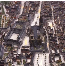
The collection of the University of Liege hosts a model which has been built by Gustave Rhul-Hauzeur (1856-1929) between 1900 and 1910. Titled, « La cité de Liège vers 1730 » (figure 1), it represents the central part of the city of Liège (scale 1/1200; around 1m²) in the Eighteenth Century. Gustave Rhul used diverse sources of information such as old maps and plans, paintings, drawings and also surveys of remaining building of the Eighteenth Century. This impressive masterpiece has a real pedagogical interest, since it shows the city before the reshaping provoked by the great industrial upheavals. However, until now, it has been underexploited for different reasons. It is not easily accessible and needs very strict conservation conditions. An interdisciplinary team of researchers has decided to work together to create documented virtual models based on Ruhl’s masterpiece. The name of the project “Virtual Leodium” makes reference to the Latin name of the city of Liège.
The long-term objective is to develop an archaeological information system, in which the Rhul’s mock-up would be one of the sources of information. The adopted methodology is influenced by the financial resources dedicated to the project; up-to-now most of the work has been carried out by students or junior researchers on a step-by-step basis.
Figure 1. Views of Gustave Rhul’s mock-up
2.2. Data acquisition and object reconstruction
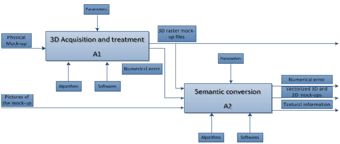
The model has been scanned using a new optical inspection technique (projected-fringes) allowing recording and processing the information that defines the precise 3D shape and chromatic characteristics of an object (Billen et al., 2009). The whole model has been scanned in several pieces and through several positions (vertical, front, back, left side, right side). The result is more than 650 individual scans which then need to be cleaned and merged. The final output is a digital surface model, which is then used as a geometric basis for individual object reconstruction. The object reconstruction procedure currently used is based on the Mayasoftware. The data processing flow is sketched in figure 2.
Figure 2. Data acquisition and object reconstruction workflow
The quality of chromatic information acquired with the laserscanner is not sufficient to obtain acceptable objects’ textures. The use of high-level digital camera is needed and the acquisition campaign is still under process.
Finally, to feed the archaeological information system, it is necessary to gather historical data. In this project, it implies to find the remaining traces of Ruhl’s work (papers, pictures, sketches, plans, etc.) and to synthesize all the discoveries made on the shape of the ancient city since the completion of the model. This work has been done by archaeologists for some specific zones of the model.
2.3. Information modelling
An ad-hoc model has been developed, gathering both geometrical and historical information. To ensure future interoperability, parts of the CityGML standard have been adopted, having in mind to obtain a CityGML compliant model. The current information model is described in figure 3. Objects in blue can be considered as extensions to a CityGML core. The characteristic of this model is to allow the management of different versions of a same element, taking into consideration the possibilities given by historical and archaeological sources. At this stage of the prototype development, the enrichment of the model is a “simple” model’s extension.
Figure 3. Simplified version of the Virtual Leodium information model
2.4. System functionalities
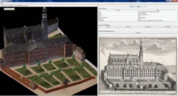
As mentioned, the long term objective is to get an archaeological information system. Therefore, the functionalities are not only restricted to visualization. Next to the 3D view, the user can see and browse the semantic data. This semantic view is organized as "web pages": from one given key data element (a building for instance), the user can reach all its direct related information (the building elements or the historical facts of the building for instance). The 3D and the semantic view are always kept synchronized: selecting in the 3D model will display the related semantic data, and browsing the semantic data will highlight the related 3D elements in the scene (figure 4).
The historical sources play a major role in this application. Any kind of images or text can be linked to a version of a building element. Multiple 3D versions of the same building element are also supported. By selecting a specific version in the semantic view, its geometric 3D representation will be displayed, immersed in 3D scene. The goal here is to allow archeologists to mix different elements from multiple historical representations of a same building. This produces new original 3D scenes based on decisions motivated by the historical documents archived in the system.
Figure 4. A snap shot of the current version of the Virtual Leodium prototype
The application is developed in Java. It relies on ArcGIS 10 for storing our geometries and the semantic data. It also takes benefits from the ArcScene API available in Java for displaying and navigating in the 3D scene.
For the semantic data viewer, a home-made abstraction layer has been developed: it automatically generates the GUI based on a high level description of what has to be displayed. That way, the application can quickly be adapted to modifications in the data model. Most of the code could also be reused in case of a completely different data model.
2.5. Current development and perspectives
Short-term developments are in one hand the finalization of a first complete representation of the model (geometry and texture) and on the other hand a feasibility study on the transformation of the model local coordinate system into the Belgian reference coordinate system. The former one aims at providing a virtual copy of the Rhul’s model for museum exhibition. The latter one aims at allowing combination with other sources of urban information and at providing the necessary step before augmented reality development. Beside these on-going activities, the core research, combining historical and geographical data, continues. More than enriching a 3D model, the objective is to use the 3D objects as containers for archaeological information, supporting complex spatio-temporal and historical analysis.
3. NANTES CASE STUDY
3.1. Goals and motivations
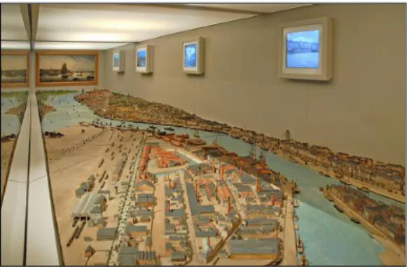
In Nantes “Château des ducs de Bretagne” museum, the room 21 is dedicated to a physical mock-up of Nantes harbour built in 1899. This relief map (figure 5) of 9.20 meters long and 1.85 meters wide (scale approximately 1/500) is both a description of Nantes history and an historical object. Indeed, it was a command of the Chamber of Commerce and Industry for the 1900 World’s Fair. Designed by Paul Duchesne, it has undergone constant changes until 1913, becoming a testimony of Nantes’ evolutions. It is made with wood, metal finishes, plant materials, paper and glass, and despite a restoration in 1996-1997, it remains relatively fragile (Guillet et al., 2001). Currently, this mock-up is simply exposed to the public in a display case. Behind it, there are videos showing pictures of Nantes harbour at different periods (1920, 1949 and 2005). This presentation is unattractive and poorly adapted to the quality of the object.
This historical object is in a middle of a broader museographic project called “Nantes1900 experiment”. This project belongs to the technical history and industrial engineering field; it also deals with 3D modelling and museographic development. The project was built as an open system that should progress. Its interest lies in its innovativeness, both in terms of the approach used but also in the methods developed in this project where high technology serves history. This project is multidisciplinary. It also requires skills from history and industrial heritage (university faculty of history and laboratory “Centre François Viète”). We may notice that one particularity of the project is that all the work is done by students. Until now, approximately 90 students and 10 researchers-teachers have worked on the Nantes 1900 project.
One of the final objective is to obtain a textured 3D model of the whole mock-up to present a new augmented reality system to the visitors. It will be composed of a touch screen coupled to a light pointer that will allow visitors to interact between the virtual and the physical models. Another goal is to develop an on-line historical database to supports all possible information on the model (both documentary and digital) that will be scalable and open source.
Figure 5. Nantes 1900 mock-up in room 21
The mock-up was digitized using a scanner from the Company Creaform (
www.creaform3d.com
). This tool allows digitizing an object to get a cloud of points. The chosen precision for the 3D digitization is 0.53 mm; that means the virtual model contains one point every 265 mm. Indeed, one obtains a 3D cloud of more than 200 millions of points at 26 cm precision but at the scale of a city (figure 6).Figure 6. Extract view of the 3D digitalisation
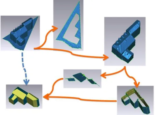
From a technological point of view, there are several steps to go from the cloud of points to 3D the virtual mock-up. The objective is to realize those operations automatically because of the large amount of triangles obtained by 3D digitalization. Nowadays, there are no technologies allowing loading and visualizing easily more than 250,000,000 points. So, first, one gets a huge cloud of points; but the acquisition is not perfect: there are some holes in the mesh. After filling them, instead of decimating manually the 3D cloud of points, we decimate it automatically (figure 7). This step allows cutting the 3D model into multiples parts that have semantic meaning. It consists of a 3D model simplification keeping the topology of the 3D cloud of points. In order to do so, the 3D vectorized mock-up is spread into multiple semantic parts. They are segmented into walls and roofs of buildings, grounds and other objects (boats) and zones (water of the river). The segmentation phase is important because it initiates the creation of an intelligent 3D mock-up. Consequently, it allows creating semantic links between the 3D virtual mock-up and data into the knowledge database (like photos, maps and geographical coordinates). Currently, only the buildings are simplified, the ground decimation is on-going.
Figure 7. Method for automatical semantic distinction
3.3. Information modelling: historical knowledge and 3D geometry storage
The simplified model will be saved in CityGML. This geographical data standard will allow keeping the building semantic obtained during the 3D cloud simplification. Furthermore, thanks to CityGML levels of detail, several simplified grounds representation could be used and textures from the mock-up pictures and could be added to the model. The global process of the Nantes 1900 project is presented in figure 8.
Figure 8. The global process for Nantes1900 project
In parallel, a knowledge database for capitalizing the context of the historical mock-up has been developed. Considering from the start that the final volume of information was unknown and that the information structure will probably evolved, we decided to design a participatory and evolutionary knowledge model. Then, researchers, experts or the public can add future contributions for enriching the database.
Figure 9. The information model of Nantes1900 knwoledge database
The database (developed with Postgres and PostGIS) consists of 2 main classes (figure 9):
Data “object” can be geographical entities existing on the physical model; or conceptual entities
related to geographical entities;
Data “resources” (text or graphics).
Each object or resource is present in the database as a “notice”. The structure of each notice is automatically adjusted in function of the resources used and the link pointed between the objects and the resources.
Data are linked together by “relations”, i.e. every object or resource is linked to various other components by specific relations (like “historical”, “documentary”, “belonging” etc.) allowing to enrich the mock-up with thematic, geographical or temporal knowledge.
The goal is to make this knowledge base available on the web allowing everyone to add information under the control of expert historians. Consequently, this knowledge enrichment will thus enrich the museum and bring its historical objects to life.
3.4. Knowledge promotion and current developments
From an industrial point of view, the main objectives of Nantes1900 project are:
To preserve the physical mock-up forever by taking a 3D picture;
And to let the object talk by itself by designing an innovative museographic system.
From a scientific point of view, thanks to the knowledge capitalisation and the 3D digitalization capture, the heritage object:
will become a new artefact eventually used by professionals of heritage domain; such as historian that can study the object directly on their laptop for example;
augmented reality). The museologic tool is based on:
The physical mock-up of Nantes harbour in 1900;
Several LCD multitouch displays;
Servers hosting a local version of the online database and the museological software;
A light pointing system (videoprojector, lasers…), controlled by the software, allowing users to
visualize selected elements in the virtual interface on the physical mock-up.
Thanks to this system, information visualization will be easier for visitors. Thus, significant work will have to be done about heterogeneous, data rendering and use cases. The system (figure 10) will allow users to reach different semantic levels of information depending on areas selected on the interface (building, group of buildings, extended geographical areas).
Figure 10. Artist view of the museological system.
Note that one of the most important constraints is that the system will be open source (museum technology choice) in order to allow evolution and upgrade of the knowledge base. Our project will also respect the museum policy: valorising heritage collections by NTIC media. Educational and fun as the same time, those facilities enrich and enlighten the museum and can reach a wider audience.
16 kiosks and over 24 broadcast stations, archives, sound clips, movies (including real-time 3D reconstruction of Nantes in 1757), and 180° immersive projection have been selected and developed by the Museum. An operating prototype will be delivered and tested inside the museum in 2014.
4. COMPARISON
These two independent projects have some clear methodological similarities but also differences:
In both cases, the original mock-ups, realised at the beginning of the 20th century for international
exhibitions, represent significant parts of the former shapes of the cities.
The scales of the models and their sizes are a bit different.
The long terms objectives are very similar; creating participatory and evolutionary historical
knowledge models, built on a 3D virtual copy of original mock-ups.
The Nantes project benefits from a strong partnership with local authorities and museum, where the
Liege project is currently built on short terms missions.
Laserscanning technologies have been adopted in both cases. However, one is a commercial device
based on time of flight method when the other one is a research development based on projected-fringes interferometry method.
The individual 3D objects (buildings mainly) are currently reconstructed manually. However, the
Nantes team is developing automatic object reconstruction techniques.
The modelling strategies have slight differences. In Nantes 1900, the knowledge is obtained by
collecting and analysing historical information about the physical objects. It structures the information system. 3D data are then inserted in the database. In Virtual Leodium, 3D virtual objects are the core structure of the information system; historical information is linked to them.
It is worth mentioning that both teams have adopted a CityGML base for their model.
Both projects involve multi-disciplinary teams (engineers, computer scientists, geomaticians,
historians, archaeologists, etc.) Data base Internet Museum Touch screen Mock-up LED Pointer consult
5. CONCLUSIONS AND PERSPECTIVES
In this paper, we have presented two projects sharing the same goal; creating participatory and evolutionary historical knowledge models, built on a 3D virtual copy of original ups. They both are based on
mock-ups realised in the early 20th century. The two projects have been described and compared. Although slight
differences can be observed, it is worth mentioning that these independent projects present remarkable similarities; context, objectives, issues, modelling choices, etc.
Those projects are multi-fields and transversal experiments requiring numerous competences:
Social and human sciences for the technical and industrial history, memories and heritage,
geographical analysis, heritage and museography…
Engineering sciences for 3D scanning, mechanical design, geomatics, mathematical computation,
informatics database, virtual reality development…
Due to the duality between engineering domain and social domain, each project is a new challenge. Such a team is heterogeneous in terms of vocabulary, problem, method of work, area of expertise, etc. Thus, the obtained results are really original and might not have been found in other circumstances, for example by professionals specialized in museographic business. Consequently, thanks to those methodologies, museums can enrich their know-how and may propose innovative and ambitious visits of their collections.
In the future, the two teams will continue sharing experiences and possibly sharing knowledge and methods to improve their own developments. Amongst others targeted domains, automatic object reconstruction and augmented reality should be the next challenges.
6. ACKONWLEDGEMENTS
The authors wish to thanks the COST (European Cooperation in Science and Technology) action TU0801 “Semantic Enrichment of 3D City Models for Sustainable Urban Development” for their support in organising the Research meeting on "Enriched 3D historical model" on 15-16 November 2011 in Liège, Belgium.
7. REFERENCES
R. Billen, P. Blain, O. Donneau, S. Habraken, Y. Renotte & M. Van Ruymbeke, 2009, “Virtual model of the city of Liège in the eighteen century - "Virtual Leodium"”. In Verly J. (Ed.), Proceedings of 3D Stereo MEDIA 2009, International 3D Stereo Film and Technology Festival (3D Stereo MEDIA), Liège, Belgium, 1-3 Dec. 2009.
C. Chevrier, K. Jacquot, J.P. Perrin, 3D modelling of a town scale model, EuroMed Conference, Limassol, Cyprus, 10 p., Nov 2010.
B. Guillet, L. Huron, J.-L. Kerouanton, “La maquette du Port de Nantes”, French congress Des villes, des ports : la mer, les hommes (n° 124; 1999; Nantes), Paris, 2001
D. Langweil, 2008, “Digitalization of Prague city, last step”, http://www.praguemodels.cz/
F. Laroche, A. Bernard, M. Cotte, 2006, “Between heritage and Industrial Engineering, a new life for old product: virtuality”, revue Research in Interactive Design, Vol.2, 7 p., Ed. Springer, ISBN 2-287-48363-2
F. Laroche, A. Bernard, M. Cotte, 2008, “Advanced Industrial Archaeology: A new reverse-engineering process for contextualizing and digitizing ancient technical objects”, Journal Virtual and Physical Prototyping, Vol. 3, n°2, Taylor & Francis, ISSN 1745-2759, pp.105-122