HAL Id: hal-03026460
https://hal.archives-ouvertes.fr/hal-03026460
Submitted on 26 Nov 2020
HAL is a multi-disciplinary open access
archive for the deposit and dissemination of
sci-entific research documents, whether they are
pub-lished or not. The documents may come from
teaching and research institutions in France or
abroad, or from public or private research centers.
L’archive ouverte pluridisciplinaire HAL, est
destinée au dépôt et à la diffusion de documents
scientifiques de niveau recherche, publiés ou non,
émanant des établissements d’enseignement et de
recherche français ou étrangers, des laboratoires
publics ou privés.
Experiment for Regional Sources and Sinks of Oxidants
(EXPRESSO): An overview
Robert Delmas, Aimé Druilhet, Bernard Cros, Pierre Durand, Claire Delon
To cite this version:
Robert Delmas, Aimé Druilhet, Bernard Cros, Pierre Durand, Claire Delon. Experiment for
Re-gional Sources and Sinks of Oxidants (EXPRESSO): An overview. Journal of Geophysical Research:
Atmospheres, American Geophysical Union, 1999. �hal-03026460�
Experiment for Regional Sources and Sinks of Oxidants
(EXPRESSO): An overview
R. A. Delmas,
l A. Druilhet,
• B. Cros,
l P. Durand,
• C.Delon,
• J.P. Lacaux,
• J.M.
Brustet,
• D. Serqa,
l C. Afire,
• A. Guenther,
2 J. Greenberg,
2 W. Baugh,
2 P.
Harley,
2 L. Klinger,
2 P. Ginoux,
2 G. Brasseur,
2 P. R. Zimmerman,
3 J. M.
Gr•goire,
4 E. Janodet,
4 A. Tournier,
4 P. Perros,
• Th.
Marion,
s A. Gaudichet,
s
H.Cachier,
6 S. Ruellan,
6 P. Masclet,
7 S. Cautenet,
8 D. Poulet,
8 C. Bouka
Biona,
9
D. Nganga,
9 J.P.
Tathy,
9 A. Minga,
9 J. Loemba-Ndembi,
9 and
P. Ceccato
1ø
Abstract. This paper presents an overview of the Experiment for Regional Sources and Sinks ofOxidents (EXPRESSO) including the objectives of the project, a detailed
description
of the characteristics
of the experimental
region
and of field instrumentation
deployed,
and a summary
of the main
results
of all components
of the experiment.
EXPRESSO is an international, multidisciplinary effort to quantify and better understand the processes controlling surface fluxes of photochemical precursors emitted by
vegetation
and biomass
burning
along
a tropical
forest
to savanna
gradient
in central
Africa. The experiment was conducted at the beginning of the dry season in November- December 1996. Three main research tools were deployed during this period: (1) the French research aircraft (Avion de Recherche Atmosph•rique et de T•l•d•tection, Fokker 27), instrumented for chemistry and flux measurements (CNRS- France), (2) two satellite receivers for in situ acquisition of National Oceanic and Atmospheric Administration- advanced very high resolution radiometer (NOAA-AVHRR) imagery for fire detection (EC-JRC, Ispra, Italy), and (3) a 65-m walkup tower installed at a tropical forest site in
the Republic
of Congo
(National
Center
for Atmospheric
Research,
Boulder,
Colorado).
Average dynamic and turbulence characteristics over savanna and forest ecosystems were retrieved from aircraft measurements. They illustrate the complex atmospheric circulation occurring in this region in the vicinity of the Intertropical Convergence Zone. Satellite receivers were operated three times a day to produce maps of fire distribution. Statistics and mapping of burned surfaces t?om NOAA-AVHRR and ERS-Along Track Scanning Radiometer space systems have been developed. The influence ofbiogenic and biomass burning sources on the chemical composition of the lower atmosphere was studied through both aircraft and tower measurements. The EXPRESSO field campaign was followed by modeling efforts (regional and global scales) in which model
components are evaluated using the experimental data. 1. Introduction
The Experiment for Regional Sources and Sinks of Oxidants (EXPRESSO) is an international and
•Laboratoire d'Arrologie, OMP, Toulouse, France.
2National Center For Atmospheric Research, Boulder, Colorado.
3Institute of Atmospheric Sciences, Rapid City, South Dakota.
4Space Application Institute, Monitoring Tropical Vegetation
Unit, Ispra, Italy.
SLaboratoire Interuniversitaire des Sciences de l'Atmosphrre, Facult6 de Sciences, Universit6 Paris XII, Crrteil, France.
6Laboratoire des Sciences du Climat et de l'Environnement, Bat
12,•Campus CNRS, Gif sur Yvette, France.
'Laboratoire d•Etude des Systrmes Atmosphrriques
Multiphasiques, ESIGEC, Universit6 de Savoie, Le Bourget du Lac,
France.
8Laboratoire Associ6 de Mrt6orologie Physique, Universit6 Blaise
Pascal, Aubirre, France.
9Universit6 de Brazzaville, Brazzaville, Congo. •øNatural Resources Institute, Chatham, England, U.K.
Copyright 1999 by the American Geophysical Union.
Paper number 1999JD900291.
0148-0227/99/1999JD900291 $09.00
multidisciplinary program designed to investigate processes
controlling chemical composition of the tropical troposphere
above central Africa and consider the impact on the global
atmosphere. Biomass burning, ubiquitous in African
savanna, exerts a dominant influence on ecology and
atmospheric chemistry. Biogenic fluxes of reactive trace gases are concentrated in tropical land areas. The high
surface fluxes observed in the tropics are likely to influence
the global atmosphere due to strong vertical mixing. The impact of human activities on trace gas fluxes in the tropics is significant (e.g., biomass buming, deforestation) and is expected to increase due to current high rates of population growth. Preliminary EXPRESSO experiments were completed in January 1994 and 1995, November 1995 and March 1996, with the major field intensive being conducted
in November and December 1996. The EXPRESSO domain extends from the savannas of southem Chad in the north (12øN) to the tropical forests of the Republic of Congo (2øN)
in the south. Several types of investigations were conducted
during this experiment. The Avion de Recherche
Atmosphrrique et de T61•d•tection (ARAT) research aircraft (Fokker 27), equipped for measuring atmospheric dynamics,
30,610 DELMAS ET AL.: EXPERIMENT FOR REGIONAL SOURCES AND SINKS OF OXIDANTS radiation, and chemistry, was the basic tool used. It
conducted 11 missions out of Bangui (Central African
Republic) overflying a range of ecosystems from savanna to
tropical forest. A detailed database of the extent of biomass
burning in central Africa during the EXPRESSO experiment
was compiled using National Oceanic and Atmospheric
Administration-advanced very high resolution radiometer
(NOAA-AVHRR) data (three acquisitions per day). A
landscape-level emission potential database for volatile
organic compounds (VOC) is being developed based on
NOAA-AVHRR landcover data, ground surveys of
vegetation type, and a vegetation VOC emission rate
database. A 60-m walkup tower, providing access to the
canopy, was installed at a nearly undisturbed tropical forest
site in the northern Congo forest. It was used to study both
forest microclimate and trace gas fluxes (especially VOC).
EXPRESSO is expected to result in improved surface trace
gas emission submodels for central Africa that can be
incorporated into global Earth system models. In addition,
EXPRESSO measurements will be used to evaluate and
improve our understanding of the production and loss of
tropospheric oxidants within this region through regional
scale modeling.
2. Scientific Background and Objectives
Tropical biomes exhibit some of the most dynamic, yet
most poorly understood biogeochemistry on Earth. The
tropics contain 40% of the global land mass and account for
about 60% of the global annual net primary productivity
(NPP) [Rodin et al., 1975]. This high productivity is
characterized by a diversity of plant species which is
unparalleled at any other latitudes. It has been estimated that
tropical forests include 66% of all plant and animal species;
many of which have yet to be described [Raven, 1988]. This
high productivity is fueled by large inputs of solar energy and
by the transformation of this energy into latent and sensible
heat, which recycles moisture in complex but predictable
meteorological regimes. These factors also make tropical
regions extremely important with respect to global atmospheric dynamics. Heat and moisture drive most
biogeochemical cycles including NPP and carbon turnover, to
which trace gas fluxes are often closely coupled, and fluxes
of many trace gas species into and out of tropical ecosystems
are expected to be high.
Field campaigns conducted in the last 15 years have
confirmed the importance of the tropics on the regional and
global composition and chemistry of the atmosphere. Biomass burning was shown to be important by the Quemadas studies in Brazil in 1979 and 1980 [Crutzen et
al., 1985]. The Global Tropospheric Experiment/
Atmospheric Boundary Layer Experiment (GTE/ABLE 2A
and 2B) in Amazonia further defined the regional chemical
composition of the Amazon basin during both wet and dry
seasons [Harriss et al., 1988]. In Africa, studies have been
done in the Congo and the Ivory Coast as part of the
Dynamique et Chimie Atmosph•rique en Forgt Equatoriale
(DECAFE) program [Fontan et al., 1992; Lacaux et al.,
1995, and references therein]. Recently, additional studies
have been completed in South America during the South
Tropical Atlantic Regional Experiment/Transport and
Atmospheric Chemistry Near the Equator-Atlantic (STARE/TRACE-A) missions [Lindsay et al., 1996], and in
South Afi'ica as part of TRACE-A/Southern African Fire-
Atmosphere Research Initiative (SAFARI) [Fishman et al., 1996]. Together, these studies have shown the following:
Biomass buming associated with agricultural activity in
the savanna, the destruction of tropical forests, and the use of
wood as fuel releases into the atmosphere large quantities of
carbon dioxide and a variety of chemically active species such as CO, odd nitrogen (NOx), N20, CH4, VOC, methyl
chloride (CH3C1), and others [Crutzen et al., 1985;
Greenberg et al., 1984]. Global annual biomass burning
represents about 1.8 to 4.7 Gt of carbon burned [Crutzen and
Carmichael, 1993], with savanna fires being the dominant
component (about 1- 1.6 Gt of carbon bumed). Savanna fires
alone contribute approximately 10% of global CO emissions
and 25% of global emissions of carbonaceous particulates
[Liousse et al., 1996]. This phenomenon is especially
important in Africa, where the contribution of savanna fires
to global emissions of trace gasses and aerosols has been
estimated by Lacaux et al. [1993] to be equal to 30% of total
biomass buming emissions.
Grassland and savanna soils release quantities of nitrogen
oxides [Johansson and Sanhueza, 1988] which, although poorly quantified, are probably sufficient in the presence of
hydrocarbons to contribute to substantial amounts of 03
production. Large quantities of NOx have been observed in
plumes of savanna fires [Crutzen eta!., 1985; Delrnas et al.,
1995]. Hydrocarbons are emitted by many biological
sources, notably the tropical forest canopy, from which VOC
emissions are expected to be dominated by isoprene
[Zimmerman et al., 1988; Guenther et al., 1995].
Evidence for the impact of fires on atmospheric chemistry
has come first from satellite data obtained from the Total
Ozone Mapping Spectrometer (TOMS) and the Stratospheric
Aerosol and Gas Experiment (SAGE) between 1979 and
1989 [Fishman and Larsen, 1987]. The tropospheric data
have shown a well-defined maximum in 03 of more than 45
Dobson
Units
(1 DU = 2.69 x 10¹⁶
molecules
of 03 per
square centimeter) off the west coast of Africa during September and October [Fishman et al., 1990]. Tropospheric 03 data obtained from ozone sondes, launchedover a 2 year period at Brazzaville, Congo (4øS), show a
maximum of 45 DU between July and September during the
fire season in southem Africa [Cros eta!., 1992; Nganga et
al., 1996]. The atmospheric mechanisms leading to 03
formation over the tropical Atlantic were well documented
during the TRACE-A experiment in 1992 [Fishman et al., 1996]. More than 50 papers published in a special issue of the Journal of Geophysical Research, lOl(D19), 1996, demonstrate the important impact of tropical sources of trace gas and aerosol on the chemical composition of the
atmosphere.
In nonurban areas, compounds released by the biosphere through biogenic or combustion processes constitute the basic mixture for photochemistry, which determines the cycle of oxidants in the troposphere, including the transformation of unstable primary products into more stable secondary products. These compounds can be transported in air masses away from source regions and thus affect the chemical composition of the atmosphere on regional and global scales.
Furthermore, vertical 03 profiles typically reveal discrete
layers of high 03 concentrations at altitudes between 1 and 5
km [Marenco et al., 1990]. This layered vertical structure indicates the importance of convective transport in the
distribution of primary and secondary products of biomass burning. Coupled with emissions associated with biomass burning, the release of volatile species by soils and vegetation contributes directly to the photochemical production of reactive chemical species.
Cloud convection favors vertical exchanges from the
boundary layer to the upper troposphere, and thus long-range transport of trace compounds coming from the continental biosphere. During TRACE-A, a series of large mesoscale convective systems that occurred during the Brazilian phase provided an opportunity to observe deep convective transport of trace gases from biomass burning. Large enhancements of CO, NOx, and hydrocarbons were observed in cloud outflow at 9-12 km altitude leading to postconvection O3 formation in the middle and upper troposphere [Pickering et al., 1996]. Jacob et al. [1996] proposed a global schema of 03 behavior in the tropical troposphere. In this model, the large-scale circulation of the tropical atmosphere is represented by the
Walker cells. The transfer of surface air masses containing
03 precursors (CO, VOC, and NOx produced by continental sources with additional NOx from lightning) occurs by deep
convection over the continents in the rising branches of the
Walker cells, driving 03 production in the middle and upper troposphere. Moreover, the most intense convective systems can cross the tropopause and inject directly into the stratosphere chemical compounds originating from surface
sources such as CI-h, NOx, and N20. These constituents
have a direct impact on the stratospheric 03 layer.
In addition, chemical transfonnations in this region are
achieved through both gas phase and heterogeneous processes. Heterogeneous processes (i.e., multiphase chemical reactions between gases and liquid or solid particles) are especially important in the equatorial zone due to the high aerosol load in the lower atmosphere, the extent of cloud coverage, and the intensity of convective activity. Haze and high levels of acidic precipitation are reported in remote tropical regions [Lacaux et al., 1992]. During the dry season, pollution events are similar in magnitude to those observed in industrialized regions. In Africa, for instance, high levels of acidity (organic and inorganic), and high particulate black carbon content in precipitation, related to biomass burning, are observed [Cachier and Ducret, 1992]. In the northern Congo forest, close to the savanna zone, the yearly average value of rainwater pH is as low as 4.4. It is estimated that 86% of this acidity results from biomass
buming which releases both organic acids [Helas et al.,
1992] and nitrogen oxides, the latter being precursors of nitric acid in the atmosphere [Lacaux et al., 1991, 1993]. The consequences of this acid precipitation, resulting from
biosphere-atmosphere exchanges, on regional scales are still unknown.
It is clear that ecological suasion, disturbance, and human-induced land use change are intense in the tropics.
These processes affect vegetation species composition, soil
microbiology, nutrient cycling, and the radiation balance of ecosystems [Nicholson, 1992]. These in tum affect trace gas emissions that impact the Earth's radiation balance and
cleansing capacity (oxidant balance) [Keller et al., 1993].
The magnitude of these changes and the regional and global
impacts are unknown.
EXPRESSO is an interdisciplinary experiment designed to
better quantify important flux processes over a range of spatial scales and to estimate their impact locally, regionally,
and globally. It is a component of the International Global
Atmospheric Chemistry (IGAC) project. The field campaign
represents an international collaboration led by European
(CNRS, France, and JRC, European Community, Ispra,
Italy) and U.S. scientists (National Center for Atmospheric
Research (NCAR), Boulder, Colorado), and conducted in
collaboration with African scientists. from Brazzaville and
Bangui Universities.
The scientific questions addressed by the EXPRESSO
project include the following: (1) What are the exchange
rates of reactive trace gases and aerosols between the tropical
biosphere and the atmosphere? (2) Are there significant
chemical interactions between the savanna and the tropical
forest? (3) What are the respective roles of photochemical
and meteorological processes in determining the chemical
composition of the atmosphere above central Africa? (4) How
are trace gas fluxes influenced by ecological processes? and
(5) What is the impact of tropical sources on the global
troposphere?
To address these questions, an experimental program has
been implemented to quantify fluxes of numerous chemical
species over a range of spatial scales from the individual leaf,
branch, and soil surface up to landscape and regional scales.
The experimental design included an intensively studied
ground station equipped with a fully instrumented tower,
complemented by derailed characterization of vegetation.
Regional survey flights and aircraft measurements along
transects between savanna and forest served to (1) monitor
the meteorology of the regional atmosphere and investigate vertical transfer mechanisms from the surface to the boundary layer and the free troposphere; (2) characterize the chemical interactions between emissions from the savanna
and the forest; and (3) assess how representative the
intensive local site measurements are of the entire savanna
and forest ecosystems.
The campaign also focused on the fate of compounds
released by the biosphere into the atmosphere. For example,
we tried to quantify O3 formation and deposition, and active
nitrogen consumption under a range of conditions.
Investigations include an examination of spatial distribution
and chemical composition of aerosols.
3. Experimental Region
3.1. GeneralThe EXPRESSO campaign was conducted in central
Africa over an area of about 1000 x 1000 km in the
northwestem part of the Congo river basin. The
experimental region is covered by open forest formations,
shrubby and grassy savanna in the Central African Republic (CAR), and dense equatorial forest in the northem Congo. Research sites were located in the savanna near Bangui (CAR) and in the forest of the northem Congo (Bomassa
2ø12.25•1, 16ø11.2'E).
3.2. General Meteorological Situation in Central Africa
The general meteorological situation over Africa is driven
by three permanent anticyclones, located on the northwest
(Azores/Canary Islands), southwest (Saint Helena), and
southeast (Madagascar). The air masses originating from
these anticyclones converge along the Intertropical
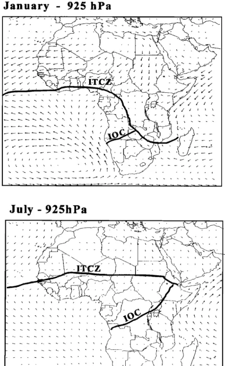
30,612 DELMAS ET AL.: EXPERIMENT FOR REGIONAL SOURCES AND SINKS OF OXIDANTS
January
- 925 hPa
July- 925hPa
.... -/'--'¾ • .>_ .... •---" •' •,- • - • ' ' - I ß ' / " ,' • .• ' ' - ,..- -, • -•-x_ \ ,-, -. -/i •- • --. "• - . , . ,Figure 1. General m•eorological circulation over A•ca in Janua• and July.
winds from the northem winds at 900 mbar, and the different rainfall regimes. Because of its position, west of the
Intertropical Oceanic Confluence (IOC), separating the IOC, the Congo is influenced only by the north trade
western and the eastern winds at 900 mbar. A low-level "Harmattan" winds and the monsoon flux (Figure 1).
monsoon flux of moist air driven by the Saint Helena In the vicinity of the convergence zone, the monsoon layer
anticyclone is trapped along the convergence zones by the is thin, while 1000 to 2000 km farther south, it reaches its high-altitude warm air originating in the north and southeast. maximum depth and produces abundant rainfall. During the
The warm monsoon flow produces a large zone of convective austral winter (June to September), the low sea surface
clouds bounded by the ITCZ and IOC. Thus the shift in the temperatures in the Gulf of Guinea produce thermal stability. position of the ITCZ and IOC during the year determines the This thermal stability decreases as the monsoon flux moves
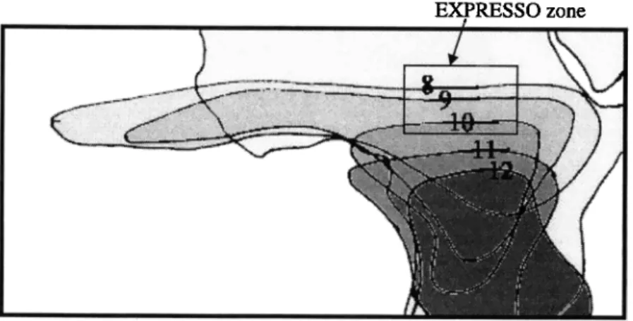
EXPRESSO zone
Figure 2. Evolution of the Intertropical Convergence Zone (ITCZ) from July to December 1996. 'Ihe
surface occupied by the elevated clouds in July corresponds to a thin zonal band t•om the Atlantic Ocean to
the African east coast. It widens on the African continent and decreases its zonal spreading in order to only
occupy the central part of equatorial Africa. The length of this zonal band decreases t•om July to
December, and its superior limit strongly falls in latitude. The limits of the cloudy zone are located on the
continent and next to the Central African Republic (CAR). The evolution of the northern limit of the band
has a velocity of 2 cm/s in July and 20 cm/s in October (maximum velocity). In November and December,
the evolution is null, the ITCZ is stabilized between 2 ø and 3øN, and its zonal extension is minimum. (The
numbers correspond to the months of the year.)
over the continent and the ITCZ reaches its northernmost position (20øN). For the northern part of the Congo, this corresponds to the wet season when convective activity
reaches its maximum, and high precipitation is observed. In October, the ITCZ moves southward, toward its southernmost position (8øN) in January. This is illustrated in Figure 2, which shows the deep convection area deduced
t•om satellite remote sensing observations (Meteosat) of
convective clouds between August and December 1996.
Over the northern part of the Congo, convective activity is then scarce, rainfall is reduced, and the season corresponds to
the dry season. The intensity of the monsoon is reduced during January and February as the ITCZ reaches its
southernmost location, but increases again in March and April as the ITCZ is displaced toward the north. In Bangui,
north of the equator, the main dry season occurs t•om December to February when the ITCZ is located at its
southernmost position and the Harmattan (dry wind t•om the Sahara) blows from the desert. The rainy season lasts t•om April to November with a slight interruption in June corresponding to the dry season south of the equator. 3.3. Ecosystems and Climate in the Experimental Region
The amount of annual rainfall and the length of the dry period largely determine the type of vegetation. Two major
ecosystems are distinguished: the equatorial forest zone and
the savanna zone. The northern part of the Congo is covered by tropical forest, while the savanna appears farther north (Central African Republic). Because there is relatively little
relief, the vegetation falls into natural latitudinal zones
determined by regional climate patterns (Figure 3, after White [1983]). Seasonal temperature fluctuations are small,
and although edaphic factors may introduce variation on a local scale, the amount and timing of rainfall assumes
overriding importance in defining these zones of potential
vegetation. Generally speaking, rainfall is maximal and most
evenly distributed near the equator, although some
seasonality is apparent even here; as one moves north t•om
the equator, the amount of annual rainfall decreases, and the
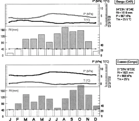
dry season becomes more distinct and longer in duration. Figure 4 illustrates the gradients in both temperature and
precipitation
between
the two stations
of Ouesso
(1ø37
N)
located
in the
primary
forest
zone
and
Bangui
(4ø23
N) in the
savanna-forest transition zone.
The large area extending t•om 4øS to 4øN and t•om the
Atlantic to the lakes and highlands of East Africa is
dominated
by tropical
lowland
evergreen
forest
or swamp
forest, depending on drainage. Bomassa, the EXPRESSOforest site, is located in the northern part of the moist forest
zone, where periods of dryness are more common than in the Zaire basin, for example. Where the moist forest zone is
relatively
undisturbed,
there is a continuous
canopy
at a
height
of 30 m or more,
with emergent
trees
rising
to 40 or
50 m. These
forests
are generally
characterized
as evergreen
or semievergreen, although a substantial fraction of treespecies
are deciduous
[Hamilton,
1989]. Although
small
patches
occur
within
the lowland
moist
forest
region
which
are dominated
by a single
(sometimes
two) tree species,
the
forests
are generally
quite
heterogeneous.
Species
diversity
is quite
large
by African
standards
(though
not compared
with Amazonia or Southeast Asia), ranging from 200 to 500
species
per
hectare
[Swaine
and
Hall, 1986],
increasing
with
increasing rainfall.As one moves north t•om Bomassa, annual rainfall
progressively
decreases,
and
the duration
and intensity
of the
dry season
increase.
This is reflected
in changes
in the
vegetation,
as largely
evergreen
forest
gradually
gives
way
to
forest with a larger deciduous component, then to woodland and dry savanna. The region of Bangui lies near the
boundary
of two vegetation
zones,
characterized
by White
[1983] as a rain forest/secondary grassland mosaic and the
30,614 DELMAS ET AL.' EXPERIMENT FOR REGIONAL SOURCES AND SINKS OF OXIDANTS
EXPRESSO
Ground
Sites and
Vegetation Zones of Central AfriCa
Atlantic Ocean
Brazzaville
Bomassa
!!• Grassland
steppe•;,"•'•
Dry
savannawoodland
;• Isoberlinia
woodland .. . .• Moist woodland savanna:• Forest/savanna
mosaic• Lowland
rainforest Swamp forest X Field sitesFigure 3. Location of EXPRESSO ground sites and vegetation zones of Central Africa.
lasting at least 5 months. Farther noah in the Central
African Republic, open woodland (i.e., crowns not touching) of deciduous trees and shrubs is typical, interspersed with
areas of tall grass [Steentofi, 1988]. The leaf area index
(LAI; m
2 leaf area/m
2 soil area)
was measured
along
a
savanna-rainforest transect in Central Africa during pre-
EXPRES'SO campaigns in 1995 and 1996 [Klinger et al.,
1998], and merged with satellite (NOAA-AVHRR) optical
data [Braswell et al., 1996]. LAI varies from less than 2 in
savanna and agricultural zones up to 6 in the rain forest, with
a tree cover of 60% in woodland savanna, 80% in Isoberlinia
forest, and 100% in rain forest (Figure 5, from Klinger et al.,
[1998])
Throughout the region of study, the vegetation
composition and structure has long been influenced by
human activity. Little undisturbed rain forest remains, and
secondary grasslands and various stages of forest regrowth
are extensive. Much of the transition between forest and
savanna (often described as a forest/savanna mosaic) was
formerly cqntinuous rain forest and reverts to forest if
protected from cutting and fire. The savanna woodlands are
particularly influenced by human activity, with large areas bumed each year during the dry season, helping to maintain
an open shrubland or grassland.
3.4. Trace Gas and Aerosol Sources and Their Impact on the Atmosphere
In the experimental region, due to the very low population
density and low level of development, anthropogenic
pollution associated with fossil fuel combustion is limited,
and atmospheric chemistry is largely dominated by
biosphere-atmosphere exchanges. The main sources of trace
gases and aerosols are biogenic emissions from soils and vegetation, and biomass burning, mainly savanna fires which are mostly anthropogenic.
Biogenic processes mainly lead to emissions of
hydrocarbons from the canopies of both tropical forest and woody savanna [Kiinger et al., 1998], nitrogen compounds
from soils in savanna and forest, and methane in the flooded
forest area which covers more than l0 s km 2 in the experimental zone. Vegetation fires have been shown to produce, in various propoaion, almost all reactive or
radiatively active trace gases, and aerosols. Owing to the
chemical composition of the phytomass, emissions are
dominated by carbon and nitrogen compounds. Basically,
trace compounds emitted by both biogenic and biomass
buming sources are similar; however, some of them (e.g., isoprene for biogenic emissions, and CO for combustion) can
P' (hPo) T('C) i Bongui (CAR) I 10 04'23N 18'34E Rf= 1510mm
• 29
27 Tm= 25.5 øCP
=
967
hPo
' 25 23 160 - Rf (ram) 0 _-160-R,
(mm)
...
tl
...
...
...
'"d
...
i_]
...
-
J F M A M J J A S O N D P' (hPo) T(øC)P'
(hPo)
110
- 5 29....
...
.
...
T (øC)
... 0 25
•l ;)7
23I Ouesso
(Congo)
I
01 '37N 16'03E Rf = 1621 mm P = 968 hP• Tm= 25'cFigure 4. Average pressure, rainfall, and temperature annual cycle at Bangui (CAR) and Ouesso (Congo).
* Total LAI
--•-'- Woody Plant LAI
100 200 I 6 . . 300 400 500 600 700 Ndoke Distance (kin) ' '- 0 Chad i Grassland Savanna
Central African Republic zaire Congo' - 40 -30 • --20 T -10 O 'O •- - 0
Woodland Isobefiinia Woodland Savanna & Transition Secondary Primary
Savanna Forest Intensive Agriculture Woodland Rainforest Rai•fforesl
Figure 5. Latitudinal variation of total leaf area index (LAI) and woody plant LAI along a savanna-rain forest transect in the EXPRESSO zone in Central Africa [•om Klinger et al., 1998].
30,616 DELMAS ET AL.: EXPERIMENT FOR REGIONAL SOURCES AND SINKS OF OXIDANTS
4km
I Research
aircraft
(AllAT) Fire
remote
sensing
studies
I Energy
budget,
turbulence
AVHRR active fire detection
,•
.._ -i 21 'Dynamics
and
thermodynamics
B'umed areas
u
in o•
m•x
• / CO,
/ 4k
03
' co
vOc,
2
.,.lsoprene
NO,-NOyAerosol
fluxes
conc.
•
...
"•:.:'"'•'"'"•5-'•'-':-"'-'•-:ø•,.,--,,.• "7•.' •
....•,-.,,....,,.
-..?:-
"•*•.
-':•
...
..
.
me,.ement
ß
UO..-MSSA
Surface
fluxes of energy
and trace compounds
Soil and vegetation
processes
5oo
kin
Figure 6. Schematic representation of the EXPRESSO field deployment during the November-December 1996 experiment, showing the main experimental tools used: the research aircraft Fokker 27 (ARAT), the instrumented Bomassa tower and tethered balloon sampling system, and the satellite receiver for detection of savanna fires.
4. Experimental Setup
The experimental concept of EXPRESSO is based on the
scientific objectives of the project. The intensive campaign took place during the dry season (November-December
1996) when the influence of biomass buming was dominant, leading to active photochemistry fueled by large inputs of hydrocarbons, CO, and nitrogen oxides. This intensive was designed to study the interactions of biomass burning with
the tropical forest.
4.1. Field Studies
The EXPRESSO intensive of November-December 1996
was prec. eAed by several campaigns in January 1994, January
1995, and November 1995, in which simultaneous satellite,
airborne, and field observations were made to calibrate and
validate fire detection and burned surface mapping
procedures [Ehrlich et al., 1995]. In the meantime, two expeditions were conducted in 1995 and 1996 in the CAR and northern Congo to characterize vegetation distribution and to screen vegetation species for VOC emissions along an 800 km transect from savanna to rain forest [Klinger et al.,
1998].
Experimental tools used are shown in Figure 6. They
include a research aircraft (AlLAT), an instrumented tower at
the Bomassa forest site, and a satellite receiving station
located in Bangui.
4.2. Local Scale
One ground site was established in the northern Congo
forest to obtain local measurements of energy and trace gas
fluxes. These measurements characterized seasonal and
daily patterns of energy exchange and trace gas emissions and are complimentary to the regional flux estimates obtained using aircraft. A 65-m walkup tower was installed at a nearly undisturbed tropical forest site on the edge of the Nouabale-Ndoki National Park in the Republic of Congo in
March 1996. The tower provided access to the forest canopy
and the surface layer above the canopy. Nouabale-Ndoki
National Park and adjacent forest reserves cover about a
million hectares of primary tropical forest, making this region
one of the largest protected areas in central Aftfica. VOC
concentrations and fluxes were measured in March and in
November/December 1996 field studies. The relaxed eddy
accumulation (REA) method was used to measure isoprene
fluxes [Guenther et al., 1996], while CO2, H20, and sensible heat fluxes were measured by the eddy covariance method [Businger and Delany, 1990]. Additional filter and cartridge
san•ples were collected for detailed analyses of VOC (C3 to
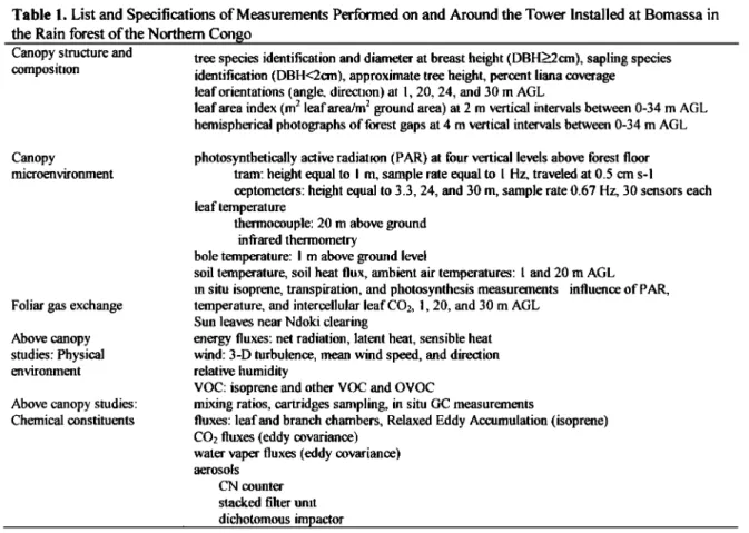
Table 1. List and Specifications of Measurements Performed on and Around the Tower Installed at Bomassa in
the Rain forest of the Northem Congo
Canopy structure and tree species identification and diameter at breast height (DBH>_2cm), sapling species
composition
identification
(DBH<2cm),
approximate
tree
height,
percent
liana
coverage
leaf orientations (angle, direction) a! 1, 20. 24, and 30 •n AGL
leaf area index (m 2 leaf area/m 2 ground area) at 2 m vertical intervals between 0-34 m AGL
hemispherical photographs of forest gaps at 4 m vertical intervals between 0-34 m AGL
Canopy
microenvironment
Foliar gas exchange
Above canopy studies: Physical
environment
Above canopy studies:
Chemical constituents
photosynthetically active radiation (PAR) at four vertical levels above forest floor tram: height equal to I m, sample rate equal to 1 Hz, traveled at 0.5 cm s-1
ceptometers: height equal to 3.3, 24, and 30 m, sample rate 0.67 Hz, 30 sensors each leaf temperature
thermocouple: 20 m above ground infrared thermometry
bole temperature: I m above ground level
soil temperature, soil heat flux, ambient air temperatures: ! and 20 m AGL
in situ isoprene, transpiration, and photosynthesis measurements influence of PAR,
temperature, and intercellular leaf CO2, 1, 20, and 30 m AGL
Sun leaves near Ndoki clearing
energy fluxes: net radiation, latent heat, sensible heat wind: 3-D turbulence, mean wind speed, and direction
relative humidity
VOC: isoprene and other VOC and OVOC
mixing ratios, cartridges sampling, in situ GC measurements
fluxes: leaf and branch chambers, Relaxed Eddy Accumulation (isoprene)
CO2 fluxes (eddy covariance)
water raper fluxes (eddy covariance)
aerosols CN counter stacked filter unit
dichotomous impactor
mass and species composition were measured along eight
transects radiating out from the tower. Over 130 different
plant species were identified. Enclosures-were used to
measure VOC, H20, and CO2 fluxes on leaves of individual
plant species so that leaf and canopy scale flux measurements could be compared. A temperature and light- controlled leaf enclosure was used to study the response of biogenic VOC emissions to changes in environmental parameters. A detailed study of canopy microclimate was conducted in order to improve canopy environment models
needed to scale measurements made on individual leaves to
entire canopies. The measurements performed at the Bomassa (Nouabal6-Ndoki) site are summarized in Table 1.
4.3. Regional Scale
Measurements from aircraf• are the only practical -way to
characterize the vertical and regional chemical composition
of air masses and to document the average dynamic and thermodynamic fields affecting the study areas. These
measurements, over a spatial scale of about 500 km and 0-4
km altitude, associated with a three-dimensional (3-D)
mesoscale meteorological model provide information on
interaction mechanisms between savanna and forest
ecosystems and will enable the partition between direct fluxes associated with the horizontal advection, entrainment at the top of the monsoon layer, and cloud transfers. At this working scale, aircraf• also provide the capability to track air parcels as they are advected from source regions and
modified by photochemical and alepositional processes.
Transformations of reactive products such as 03 can be followed in air masses during their transfer from savanna to
forest zones.
The aircraft used in this study was the French research aircraft ARAT owned and operated by Institut G6ographique National (IGN) and managed by Institut National des
Sciences de l'Univers (INSU). The ARAT is a measurement
platform with a large spectrum of capabilities (Table 2). Most of sensors are situated in the 6 m long nose boom, along the fuselage or inside the cabin. Positioning is made -with an Inertial Navigation System (INS), a satellite Global Positioning System (GPS), a radioaltimeter, a standard barometer altimeter, and a downward looking video camera.
Dynamics measurements use INS and accelerometers to
define the aircraft movement relative to the ground. Different
sensors are used to calculate the airflow related to the
aircraft, pressure, temperature, humidity, and speed fluctuations. The air motion relative to the ground is computed by difference. Many upward and downward
radiation sensors measure visible, visible red, IR, and UV
radiation, as well as surface temperature and radiance. Microphysics, physics, and chemistry are important pans of this experiment. The different sensors and analyzers monitor
the liquid water content in clouds, the concentration and size
distribution of aerosols, the average concentration and fluctuations of O3, the concentrations of nitrogen oxides (NO- NO2-NOy), CO2, CO, and VOC. The relaxed eddy
accumulation technique, developed for the EXPRESSO
campaign, was used to measure CO2 and isoprene turbulent
fluxes averaged on horizontal low-altitude flight legs of about
30 km. Two sampling lines were devoted to isokinetic
sampling of aerosols.
During the 12 operational days of the aircraft campaign, 11 scientific flights were made (totaling 24 hours), partly
30,618 DELMAS ET AL.: EXPERIMENT FOR REGIONAL SOURCES AND SINKS OF OXIDANTS
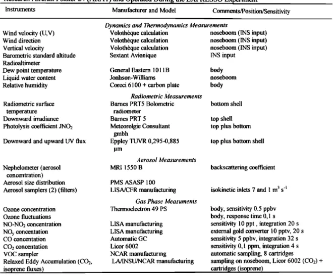
Table 2. Dynamic Thermodynamic, Radiometric, and Chemistry Measurement Systems Installed on Board the
Research
Aircraft
Fokker
24 (ARAT)
and
Operated
During
the
EXPRESSO
Experiment
Instruments
Manufacturer
and
Model
Comments/Position/Sensitivity
Wind velocity (U,V)
Wind direction
Vertical velocity
Barometric standard altitude Radioaltimeter
Dew point temperature
Liquid water content
Relative humidity
Radiometric surface
temperature
Downward irradiance
Photolysis coefficient JNO2
Downward and upward UV flux
Nephelometer (aerosol
concentration)
Aerosol size distribution
Aerosol samplers (,2) (filters)
Ozone concentration Ozone fluctuations NO-NO2 concentration NOy concentation CO concentation CO2 concentation VOC sampler
Relaxed Eddy Accumulation (CO2,
isoprene fluxes)
Dynamics and Thermodynamics Measurements
Voloth•que calculation noseboom (INS input) Voloth•que calculation noseboom (INS input) Voloth•que calculation noseboom (INS input) Sextant Avionique INS input
General Eastern 1011B body
Jonhson-Williams noseboom
Coreci 6100 + carbon plate body
Radiometric Measurements
Barnes PRT5 Bolometric bottom shell radiometer
Barnes PRT 5 top shell Meteorolgie Consultant top plus bottom
gmbh
Eppley TUVR 0,295-0,885 top plus bottom shell
Aerosol Measurements
MRI 1550 B backscattering coefficient
PMS ASASP 100
LISA/CFR manufacturing
Gas Phase Measuments Thermoelectron 49 PS LISA manufacturing LISA manufacturing Automatic GC Licor 6002 NCAR manufacturing LA/INSU/NCAR manufacturing
isokinetic inlets 7 and I m 3 s '•
body, sensitivity 0.5 ppbv body, response time 0,1 s sensitivity 10 ppt, integration 20 s external gold converter 10 pptv, 20 s sensitivity 5 ppbv, integration 32 s sensitivity 0,1 ppm, integration 4 s automatic sampling, 8 cartridges sampling on noseboom, Licor 6002 (CO2) +
cartridges (isoprene)
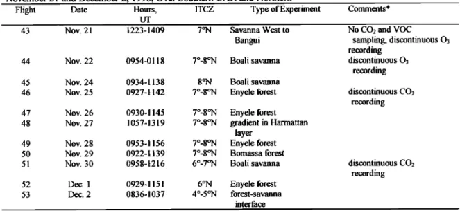
flights: 44, 45, 51), and partly over the Eny616 rain forest
(120 km south of Bangui, four flights: 46, 47, 49, 52) (Table
3). Two transect flights were made, one to study the
evolution of air masses in the Harmattan layer (flight 48) and
one to fly over the Bomassa-Ndoki ground station in the
northern Congo (flight 50). A test flight at the beginning of
the campaign was made west of Bangui (43), and a last flight
at the end of the campaign was made across the savanna-
forest interface (Figure 7). Flights were carried out between
11 00 and 1300 local time, the period of highest energy and
fully developed boundary layer. Flight paths over the Boali
savanna and the Enyele forest had the same pattem to study
vertical exchanges from the surface to the free troposphere up
to 4 km altitude. These flights included stabilized flight legs of about 30 km perpendicular to the mean wind direction: three low-altitude legs at about 100 m above ground level, one leg in the middle of the boundary layer, three legs at the
top of the boundary layer, and two or three legs above.
The data collected on the aircraft allowed investigation of the following: (1) energy and mass balance in the homogeneous boundary layer over the savanna and the forest as well as turbulent kinetic energy budget and entrainment of
air masses at discontinuity surfaces, (2) concentrations of
NO•, NOy, and Os as well as Os deposition flux onto the forest and savanna canopies to retrieve the O3 budget at
regional scale, (3) VOC and isoprene fluxes above savanna
and forest, (4) concentrations of CO to provide a tracer of fire
activity, and (5) particle concentration, size distribution, and
chemical composition.
4.4. Vegetation Fire Studies
The satellite monitoring of biomass buming during the IGAC EXPRESSO experiment was performed by the
Monitoring Tropical Vegetation Unit of the Joint Research
Center. This work helped assess the fluxes of trace gases
and aerosols emitted by dry season central African savanna fires. The study area covers the transition zone between the
savanna and the forest domains. Satellite remote sensing is
the only technology that allows consistent data collection of the spatial and temporal distribution of fires at the scale required by the EXPRESSO experiment.
A portable monitoring system was developed and
operated, in collaboration with the ORSTOM and NRI
Institutes in central Africa for the in situ, real-time
acquisition and processing of NOAA-AVHRR imagery [Belward et al., 1993; danodet et al., 1996]. The
acquisitions were initiated in D•ber 1993 and ended in
December 1996. A total of 1058 acquisitions were made during this period, establishing a database of satellite imagery over almost four buming seasons.
Table 3. List and Characteristic of Experimental Flights Performed During the EXPRESSO Experiment Between
November 21 and December 2, 1996, Over Southern CAR and Northern
Flight Date Hours, ITCZ Type of Experiment Comments*
43 Nov. 21 1223-1409 7øN Savanna West to
Bangui
44 Nov. 22 0954-0118 7ø-8øN Boali savanna
45 Nov. 24 0934-1138 8øN Boali savanna
46 Nov. 25 0927-1142 7ø-8øN Enyele forest 47 Nov. 26 0930-1145 7ø-8øN Enyele forest
48 Nov. 27 1057-1319 7ø-8øN gradient in Harmattan
layer
49 Nov. 28 0953-1156 7ø-8øN Enyele forest
50 Nov. 29 0922-1139 7ø-8øN Bomassa forest 51 Nov. 30 0958-1216 6ø-7øN Boali savanna
52 Dec. 1 0929-1151 6øN Enyele forest
53 Dec. 2 0836-1037 4ø-5øN forest-savanna
interface
No CO2 and VOC
sampling, discontinuous 03 recording discontinuous 03 recording discontinuous CO2 recording discontinuous CO2 recording
* Flights 44, 45, 51 (Boali savanna) and 46, 47, 49, 52 (Enyele forest) were dedicated to the study of turbulence and vertical
exchanges between boundary layer and free troposphere over homogeneous areas of savanna and rain forest. During the 11
flights, all instrumentation for dynamics, thermodynamics, radiation, aerosols, and gas phase chemistry measurements worked
except for those mentioned in this column. Six cartridges for VOC analysis were sampled during each flight along with four to
five filters for determination of the chemical composition of aerosol. Three to five REA sampling for CO2 and isoprene flux determination were performed on each flight.
The in situ availability of daily fire maps was not only
directly used for quantifying fluxes, but also to help in the guiding and planning of airborne campaigns. The 1994 and 1995 pre-EXPRESSO campaign used the near real-time availability of AVHRR fire maps to identify regions of intense fire activity and guide fire detection verification and validation air surveys. These used GPS systems to locate fires and multispectral video cameras to characterize fire size and front morphology from aircrat•. The portable monitoring system was operated in central Africa for the in situ, real- time acquisition and processing of NOAA-AVHRR imagery during the EXPRESSO dry season field campaign, which
lasted from October 1, 1996, to December 2, 1996. One
AVHRR scene per day was processed to locate active fires
and burned areas. A set of 25 images, acquired between
October 31 and December 2, 1996, was analyzed to detect
active fires and burned surfaces. The images were
preprocessed to eliminate radiometric noise, and clouds were screened with the multiple threshold algorithm used in the production of the IGBP-DIS global fire product. Active fires
were detected with the IGBP-DIS contextual algorithm, and
burned surfaces were mapped using a procedure based on
GEMI3, a modified version of the Global Environmental
Monitoring Index (GEMI), which is highly sensitive to the presence of burned surfaces and strongly resistant to the atmospheric effects of smoke aerosols. Daily estimates of
fire occurrence were produced and mapped to represent the
spatial dynamics of biomass buming during the campaign.
Fire distribution information was coupled with other
databases that provide (1) fuel load retrieved from satellite data coupled with a net primary production model and (2)
burning efficiency and emission factors so that trace gas fluxes could be estimated. Fluxes were then integrated
regionally on the basis of the daily maps ofbumed areas.
4.5. Modeling
Previous campaigns in the last decade have highlighted
the difficulty of establishing the interactive role of fluxes,
transport, chemical transformations, and removal of gases
and particles in the tropical troposphere. Modeling is
complicated because major processes in the atmosphere act
on a wide range of spatial and temporal scales, so that
assessment of the net effect is difficult. The objectives of the
EXPRESSO modeling studies are to (1) help to understand
and interpret the EXPRESSO field measurements, (2)
provide a framework for using EXPRESSO measurements to
initialize, validate, and further refine atmospheric
transport/chemistry models in tropical zones, and (3)
characterize the emissions from biomass burning in the
savanna and from the equatorial forest and assess their
importance on atmospheric chemistry at local, regional, and
global scales.The studies include two major modeling topics: (1) process modeling of surface exchanges, using hydrocarbon flux models, and emission ttuxes from soil and
(2) large-scale comprehensive modeling that includes the
following:
1. A regional model is used to couple emissions, chemistry,
and transport. Emphasis will be on quantifying the sources
and sinks that are regionally driven by convection, vertical exchanges betw• the boundary layer and the free troposphere, horizontal transport in the vicinity of the ITCZ,
and exchanges between savanna and forest zones. The
meteorology is simulated using a three-dimensional
mesoscale model, Regional Atmospheric Modeling System
(RAMS) in its nonhydrostatic version [Pielke et al., 1992].
This model is also used to compute the distribution of a
chemical tracer (CO) characteristic of biomass buming
30,620 DELMAS ET AL.' EXPERIMENT FOR REGIONAL SOURCES AND SINKS OF OXIDANTS
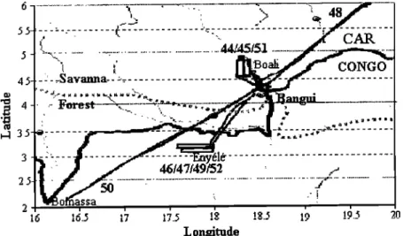
•.•_ __•
... •'• ... L=
... -_'_
... :.=•
...
4.5-
- :- ...avanna-
-='::..-.
... _•
...
• ... -• ... ,•,• ...-- -z
...
-EnyMk
... '::-
... ':-
...
= .
...
...
...
...
2 i i i i i i ,I.U .I. J' I J .-• • .... 1• ... LongitudeFigure 7. Flight areas during the EXPRESSO campaign. Flight numbers are specified under each flight track (thin lines). The thick line correspond to the frontier between CAR and Congo.
of CO fluxes retrieved from satellite data. The distributions
obtained are compared with aircraft observation in order to
improve biomass burning sources. In a second step, this
model will be coupled with a chemical module to simulate
the photochemistry over the entire EXPRESSO region.
2. The Model for Ozone And Related chemical Tracers
(MOZART) model [Brasseur et al., 1996] is dedicated to a global analysis. It simulates the distribution of 29 species on
the global scale fom the surface to the upper stratosphere
with a resolution of 2.8 ø x 2.8 ø in the horizontal.
3. Interactive regional/global modeling to bridge the gap between large-scale and subgrid-scale phenomena through nesting techniques, zooming techniques, and budgets, or yield calculations, is achieved with a third model [Ginoux
and Brasseur, 1997]. This model is able to solve the
equations on an irregular grid which allows it to use a 50 km
resolution over central Africa and 1000 km over the Pacific.
The distribution of 46 species is computed over the period
covering the EXPRESSO measurements.
4.6. EXPRESSO Database
A global database has been developed to provide EXPRESSO investigators with a centralized tool for data
management, and help collaborations, with the final
objective of ensuring the largest distribution of EXPRESSO
data to the scientific community. The EXPRESSO database
contains the following (1) data collected during EXPRESSO observation periods (ground, airborne, and satellite
measurements) and validated by principal investigators; (2)
meteorological data from ground stations, and inputs and outputs fom ECMWF model (wind, temperature, humidity, vorticity and divergence fields, back trajectories); and (3) satellite products derived from data collected during
preparation period (three dry seasons).
The distribution of data is done with two complementary
means: (1) WWW server which provides on-line access to
catalogue and documentation, an extraction interface
allowing the importation of data sets according to different
criteria and display capabilities to assist the users in data set
selection, and (2) CD-ROMs gathering validated archive
data which have the same functions as the WWW server.
The MEDIAS (MEDIt•rran•e et Afrique Subtropical) Research Center is in charge of the development and administration of the database under the responsibility of the EXPRESSO manager. The EXPRESSO database will be opened to the scientific community in 1999.
5. Outline of the Main Results
Following the STARE/SAFARI experiment in southem African tropics, the EXPRESSO experiment highlights the impact of tropical sources of trace gases and particles on the chemical composition of the atmosphere. This experiment combined ground-based, aircraft, and remote sensing measurements, allowing investigation of surface fluxes of
energy and trace gases from both savanna and forest
ecosystems on one hand, and photochemical and dynamic
processes in the lower atmosphere on the other hand. Several
results can be emphasized:
1. The energy balance of both ecosystems is primarily
determined by evaporation (latent heat flux) with Bowen
ratios of the order of 0.2 and 0.45 over forest and savanna,
respectively. The kinetic energy budget in the boundary layer
is dominated by thermal (versus dynamic), production. This
may be due to very weak horizontal winds in the vicinity of the ITCZ, in spite of the strong roughness of both ecosystems
(Delon e! al., unpunblished manuscript, 1999a). The
location of the experimental domain, at the interface between savanna and forest ecosystems and in the middle of the ITCZ, results in a great complexity of dynamic fields as shown by air mass back trajectories, calculated fom
ECMWF model, in the boundary layer and the fee
troposphere. This complex circulation is quite well simulated by the three-dimensional mesoscale model RAMS which reproduce the main jets, that is, Harmattan and
monsoon flows, as well as divergence and convergence areas.
In addition, the model is able to simulate a vegetation breeze,
induced by diurnal temperature gradients at the savanna-
forest interface, which may play a significant role in horizontal exchanges between both ecosystems [Cautenet et al., this issue]. Vertical exchanges between the boundary layer and the free troposphere (monsoon and Harmattan