HAL Id: hal-00070934
https://hal.archives-ouvertes.fr/hal-00070934
Submitted on 8 Aug 2014
HAL is a multi-disciplinary open access
archive for the deposit and dissemination of sci-entific research documents, whether they are pub-lished or not. The documents may come from teaching and research institutions in France or abroad, or from public or private research centers.
L’archive ouverte pluridisciplinaire HAL, est destinée au dépôt et à la diffusion de documents scientifiques de niveau recherche, publiés ou non, émanant des établissements d’enseignement et de recherche français ou étrangers, des laboratoires publics ou privés.
Evolution of the Rhone Delta coast since the end of the
19th century
François Sabatier, Serge Suanez
To cite this version:
François Sabatier, Serge Suanez. Evolution of the Rhone Delta coast since the end of the 19th century. Géomorphologie : relief, processus, environnement, Groupe français de géomorphologie (GFG), 2003, 9 (4), pp.283-300. �10.3406/morfo.2003.1191�. �hal-00070934�
Evolution of the Rhône delta coast since the end of the 19th
century / Cinématique du littoral du delta du Rhône depuis la fin
du XIXe siècle
In: Géomorphologie : relief, processus, environnement. Octobre-décembre, vol. 9, n°4. pp. 283-300.
Abstract
Abstract The evolution of the Rhône delta coast is analysed using digitally processed data obtained from field surveys effected in 1895, aerial photographs taken in 1940, 1950, 1960, 1970, 1980 and 1990, and a DGPS-based survey carried out in 2000. The whole dataset was integrated into a Geographic Information System to determine coastline retreat and advance and to quantify gains and losses of land area at the coastal fringe of the delta. It is shown that sediment input from the Rhône, longshore drift currents and sea defences have had a marked influence on space-time variations of the position of the coastline. These data enable characterisation of the morphose- dimentary circulation at the coast, and the identification of a clear pattern of littoral sediment cells.
Résumé
Résumé La cinématique du littoral du delta du Rhône est étudiée par le traitement numérique de relevés de terrains effectués en 1895, de photographies aériennes prises dans les années 1940, 1950, I960, 1970, 1980, 1990, et d'un relevé au DGPS (Differential Global Posi- tionning System) réalisé en 2000. L'ensemble de ces données a été intégré dans un Système d'Information Géographique pour déterminer des vitesses de recul et d'avancée du trait de côte et pour quantifier les surfaces gagnées ou perdues par la frange littorale. Le rôle des apports sédimentaires rhodaniens, des courants de dérive, et des ouvrages de défense du littoral, dans les variations spatiotemporelles de la position du trait de côte, est mis en évidence. Ces données permettent de dessiner la circulation morphosédimentaire à la côte qui s'organise en cellules de dérive littorale.
Citer ce document / Cite this document :
Sabatier François, Suanez Serge. Evolution of the Rhône delta coast since the end of the 19th century / Cinématique du littoral du delta du Rhône depuis la fin du XIXe siècle. In: Géomorphologie : relief, processus, environnement. Octobre-décembre, vol. 9, n°4. pp. 283-300.
doi : 10.3406/morfo.2003.1191
Géomorphologie : relief, processus, environnement, 2003, n° 4, p. 283-300
Evolution of the Rhône delta coast since the end of the 19th century
Cinématique du littoral du delta du Rhône depuis la fin du xixe siècle
François Sabatier* and Serge Suanez ** Abstract
The evolution of the Rhône delta coast is analysed using digitally processed data obtained from field surveys effected in 1895, aerial photographs taken in 1940, 1950, 1960, 1970, 1980 and 1990, and a DGPS-based survey carried out in 2000. The whole dataset was integrated into a Geographic Information System to determine coastline retreat and advance and to quantify gains and losses of land area at the coastal fringe of the delta. It is shown that sediment input from the Rhône, longshore drift currents and sea defences have had a marked influence on space-time variations of the position of the coastline. These data enable characterisation of the morphose- dimentary circulation at the coast, and the identification of a clear pattern of littoral sediment cells.
Key words: Geographic Information System, spit, beach, coastal defences, littoral cell. Résumé
La cinématique du littoral du delta du Rhône est étudiée par le traitement numérique de relevés de terrains effectués en 1895, de pho tographies aériennes prises dans les années 1940, 1950, I960, 1970, 1980, 1990, et d'un relevé au DGPS (Differential Global Posi- tionning System) réalisé en 2000. L'ensemble de ces données a été intégré dans un Système d'Information Géographique pour déter miner des vitesses de recul et d'avancée du trait de côte et pour quantifier les surfaces gagnées ou perdues par la frange littorale. Le rôle des apports sédimentaires rhodaniens, des courants de dérive, et des ouvrages de défense du littoral, dans les variations spatio temporelles de la position du trait de côte, est mis en évidence. Ces données permettent de dessiner la circulation morphosédimentaire à la côte qui s'organise en cellules de dérive littorale.
Mots clés : Système d'Information Géographique, flèche littorale, plage, digues, épis, cellules de dérive littorale.
Version française abrégée analyse séculaire (entre 1895 et 2000) de l'ensemble du li ttoral du delta du Rhône.
Le delta du Rhône est un delta dominé par la houle dont Plusieurs étapes, reprises et commentées par M. Provan- la forme générale s'articule autour de deux bras : le Grand sal et al. (ce volume), décrivent la construction holocène du Rhône à l'est et le Petit Rhône à l'ouest des Saintes-Mariés- delta du Rhône qui commence aux alentours de 7000 BP. de-la-Mer. La frange littorale représente environ 90 km de Cette histoire montre que l'allure générale du littoral actuel côtes sableuses qui s'étendent de la flèche de la Gracieuse à est atteinte au début du xvnr siècle laissant en mer une mor- l'est de l'embouchure du Grand Rhône jusqu'au complexe phologie particulière en lobes (Bras defer et Pégoulier) en touristique du Grau-du-Roi à l'ouest de la flèche de l'Espi- face des anciennes embouchures (Vieux Rhône et ancien guette (fig. 1). Alors que les travaux antérieurs sur la ciné- débouché du Grand Rhône) (fig. 2 et fig. 3). Les données sur matique du rivage ne concernent que la partie orientale du la charge solide rhodanienne indiquent une diminution des delta du Rhône pendant une cinquantaine d'années (Suanez apports depuis le XIXe siècle : entre 22 et 30 Mt/an au tout et Simon, 1997 ; Suanez et al., 1998), cet article propose une début du XXe siècle (Surell, 1847 in Vernier, 1976 ; Pardé,
* Delft University of Technology, Faculty of Civil Engineering, Hydraulic Engineering Section, Stevinweg 1, 2628 CN Delft, The Netherlands and CEREGE, UMR 6635 CNRS, Centre Européen de Recherche de l'Environnement, Europôle Méditerranéen de l'Arbois, 13545 Aix-en-Provence Cedex 4, France. E-mail : [email protected] * * GEOMER, UMR 6554 CNRS-Université de Bretagne Occidentale, Institut Universitaire Européen de la Mer, Technopôle Brest-Iroise, Place Nicolas Copernic, 29280 Plouzané, France. E-mail : [email protected]
1925) puis 7,39 à 9,6 Mt/an à la fin de ce même siècle (Anto- nelli, 2002 ; Pont et al., 2002). Cette diminution s'explique par une moindre fréquence des crues annuelles (Pichard, 1995) en relation avec la fin du Petit Âge Glaciaire. Les effets du climat sont également amplifiés par les mutations de l'occupation du sol dans le bassin versant : la déprise agricole, la reforestation et l'aménagement des cours d'eau, notamment la construction des barrages hydro-électriques à partir des années 1950-1960 qui piègent une grande partie de la charge fluviale grossière. Les houles et les courants qu'elles induisent restent les agents déterminants de la dynamique marine. Les houles proviennent de trois direc tions principales (fig. 4). La houle de SW est la plus fré quente (30 % du total du régime) mais elle est peu énergét ique. Les houles de SSE etESE représentent respectivement 16 % et 11 % du régime total annuel ; elles sont très éner gétiques et associées à la cyclogenèse méditerranéenne qui se manifeste principalement aux périodes d'équinoxe. Aujourd'hui, plus de 80 % de la frange littorale est équipée de structures de protection côtière (Suanez et Sabatier, 1999). La flèche de la Gracieuse est renforcée par une dune artificielle depuis 1988 tandis que l'avancée des crochons est contrôlée par l'échouage de barrages qui jouent le rôle d'épis (photos 1 et 2). Le littoral de Faraman, des Saintes- Maries-de-la-Mer et de Petite Camargue est équipé de plu sieurs batteries d'épis, de nombreuses digues et de quelques brises-lames depuis le milieu des années 1980 (photos 3, 4 et 5). Au bout de la flèche de l'Espiguette, une digue a été édifiée en 1968 pour bloquer le transit littoral et protéger la marina de Port Camargue de l'ensablement (photo 6).
Les données utilisées dans cet article pour étudier la ciné matique du littoral du delta du Rhône reposent : 1) sur des levés de la position du rivage qui ont été effectués par les ingénieurs de l'EPSHOM en 1895 ; 2) sur une collection de photographies aériennes couvrant la période allant de 1944 à 1998 avec une périodicité de 5 à 10 ans (tab. 1) ; enfin, 3) sur un levé effectué en 2000 au moyen d'un GPS différentiel. Reposant sur des techniques modernes de traitement numér ique d'images et d'analyse par Système d'Information Géo graphique (SIG), ce travail fournit des données nouvelles et
exhaustives sur les variations du trait de côte (fig. 5 à 10) et sur les surfaces gagnées ou perdues par la frange littorale
(fig. 11 et fig. 12).
Les variations du trait de côte montrent que, sur l'e nsemble de la période, les valeurs les plus importantes sont enregistrées à proximité des embouchures du Grand Rhône et du Petit Rhône, respectivement +2500 m et -1000 m ainsi que sur les flèches sableuses de la Gracieuse (+2600 m), de Beauduc (+1500 m) et de l'Espiguette (+1500 m) (fig. 5, 6, 8, et 10). Les littoraux de Faraman, des Saintes-Maries-de- la-Mer et de la Petite Camargue qui représentent 70 % du linéaire côtier sont soumis à l'érosion et enregistrent re spectivement un recul supérieur à 250 et 500 m depuis 1895
(fig. 7 et 9). L'évolution séculaire nette entre les surfaces gagnées et perdues par la frange littorale est excédent aire de 2,38 km2, mais dans le détail, trois périodes se dis tinguent (fig. 11). Entre 1895 et 1944, le littoral camarguais enregistre un gain de 3,87 km2, entre 1944 et 1987-89-90
une perte de 1,70 km2 et enfin un léger gain de 0,21 km2 entre 1987-90 et 1998-2000. La répartition spatiale de l'évolution de la frange littorale divise le littoral du delta du Rhône en deux secteurs (fig. 12) : le premier, de la flèche de la Gracieuse à l'est du Grau de la Dent où les variations du trait de côte sont chaotiques et ne montrent pas de tendance évidente sur la durée de l'étude ; le second, situé à l'ouest du Grau de la Dent jusqu'à l'Espiguette, où les secteurs en recul et en avancée se distinguent clairement.
Les résultats de la cinématique du rivage mettent d'abord en évidence le rôle des structures de protection côtière qui limitent le recul du rivage depuis les années 1980 et 1990. Cependant, l'évolution sous-marine demeure mal connue et l'on peut s'attendre à une déstabilisation des ouvrages à plus long terme (Paskoff, 1998 ; Sabatier et Provansal, 2002). Ensuite, notre analyse souligne les liens entre l'évolution de la frange littorale et les apports sédimentaires du fleuve à la mer. Pendant les périodes de forts débits (entre 1895 et 1944), le littoral avance tandis qu'il recule ensuite (entre 1944 et 1987-90) en relation avec une diminution drastique des apports rhodaniens. Cette dernière s'explique par la déprise agricole et avec elle, la re-végétalisation du bassin versant rhodanien (Bravard, 1989 ; Warner, 2000). De plus, cette période enregistre les conséquences de la fin du Petit Âge Glaciaire auxquelles s'ajoutent, à partir des années 1950-1960, les effets de la construction des barrages hydro électriques qui piègent une grande partie des débits solides fluviaux (Klingeman et al., 1994 ; 1RS, 2001). Enfin, la ciné matique du trait de côte est interprétée selon le concept de la cellule de la dérive littorale qui associe un secteur d'accu mulation alimenté en sables par un secteur en cours d'éro sion sous l'effet de la circulation modale des courants de dérive (Komar, 1998) (fig. 13). Nous distinguons quatre cel lules littorales dont la plus originale (CEL 3) se trouve dans la partie centrale du delta où elle est alimentée à l'est et à l'ouest par deux secteurs en voie d'érosion (fig. 13). Le golfe et la flèche de Beauduc jouent aujourd'hui le rôle de "réser voir" pour le littoral du delta du Rhône tout comme le pro delta de Roustan qui est nourri par les apports rhodaniens. Le démantèlement des sous -deltas fossiles de Pégoulier et du Bras de Fer participe également à la dynamique morpho- sédimentaire actuelle en alimentant en sables le littoral.
La connaissance de la cinématique du trait de côte, depuis 105 ans, effectuée au moyen d'un SIG permet de pro poser des cartes utiles aux aménageurs de l'espace littoral.
Introduction
The evolution of the Rhône delta coast (fig. 1) has been the subject of many studies, the earliest of which date back to the 1950s (Duboul-Razavet, 1956; Juniet, 1962; Vernier, 1976; Blanc, 1977). These studies were very localised and based on classical techniques of manual cartography that, nevertheless, threw light on the recent evolution of this del taic coast. However, such studies failed to provide quantita tive information at the scale of the entire delta. The first general mapping study used to quantify the changes of the Camargue coastline dates from the early 1990s (L'Homer, 284 Géomorphologie : relief, processus, environnement, 2003, n° 4, p. 283-300
Evolution of the Rhône delta coast since the end of the 19th century 1992). This author gave values of coastal retreat and
advance in m/yr for the decade 1980, and made a forecast for 2025. However, his results were not based on any precise methodology but simply on the compilation of the pre viously quoted work.
Recently, S. Suanez and B. Simon (1997) and S. Suanez and M. Provansal (1998) realised a diachronic study of sho reline change at the semi-secular scale on the eastern part of the delta, from La Gracieuse spit to the Gulf of Beauduc (fig. 1). Although these efforts have been useful in explai ning patterns of shoreline behaviour, there is still a need for investigation of time-space behaviour of the entire Rhône delta shoreline. The present study aims to analyse the such change between 1895 to 2000, based on modern techniques of digital image analysis and treatment by GIS (Geographic Information System). This study provides new and more precise data on the evolution of the Rhône delta coast over a time span of more than a century. The present results also confirm the important role played by variations in the sed iment input of the Rhône in controlling sediment supply to the beaches. Finally, the study shows the contribution of coastal defence structures in the protection or possible ero sion of the coastline.
Environmental setting Presentation of the site
According to the classification of W.E. Galloway (1975), the Rhône delta is recognised as a wave dominated delta. The shoreline is made up of approximately 90 km of sandy barred beaches extending from La Gracieuse spit to Espi- guette spit (fig. 1). The bifurcation of the river upstream of Aries gives rise to two arms: the Grand Rhône in the east, which runs into the sea at the Grau de Roustan, and the Petit
Rhône in the west, whose outlet, the Grau d'Orgon, is situa ted to the west of Saintes-Maries-de-la-Mer. The general shape of the coastline is formed around these two arms.
The build-up of the Rhône delta plain began at around 7,000 years BP and took place in several stages (Kruit, 1955; Triat-Laval, 1978; Pons et al, 1979; L'Homer et al, 1981; Arnaud-Fassetta, 1998; Vella and Provansal, 2000; Vella, 2002; Provansal et al, this volume). While it is outside the scope of this article to give a description of this history, it is important, nevertheless, to mention the role of: 1) sediment supply from the Rhône river in controlling the rate and degree of coastal progradation, 2) swell wave action leading to the lateral redistribution of sedimentary material, 3) varia tions in sea-level favouring the progradation of the coastline during regressive phases (stagnation), or on the contrary, lea ding to filling of the channels that partly controls avulsion of the riverbed during transgressive phases.
The current shoreline began to take its present shape from the beginning of the 18th century. Following an important flood in 1711, the Rhône of the Bras de Fer channel changed course towards the east and assumed it present-day configu ration as the Grand Rhône (fig. 2). Erosion of the deltaic lobe abandoned by the shift of the channel led to the build-up of the Beauduc spit towards the west (fig. 2). During the 19th century, the position of the mouth of the Grand Rhône was directly related to human activities. From a natural configu ration with three outlets (Graus de Piémanson, Roustan and Pégoulier), the mouth was artificially concentrated initially towards the southeast (Grau de Pégoulier), and then after 1892 towards the south (Grau de Roustan) (fig. 3). Since the beginning of the 18th century, successive displacements of the mouths have thus given rise to the offshore abandonment Fig. 1 - Location map.
Fig. 1 - Carte de localisation. Algues-Mortes
- - ^ Orgon „ — 10 m ~ LITTORAL of PETITE CAMARGUE
^ Grau de la Dent „. LITTORAL: OF FARAMAN
Fossil sub-delta of Bras de Fer
; Fossil sub-delta šoustán óf Pégoulier Nord MO km MEDITERRANEAN SEA 43 30' 43 25' 43 20' H 4 10' 4'30' 4'40' 4'50'E
Rhône of the Bras de Fer (Vieux Rhône)
from 1587 to 1711 erosion of the deltaic lobe of the Bras de Fer (after 1711) Fig. 2 - Shifts of the Grand Rhône Channel from L'Homer et al.,
1981. A: from 1587 to 1711; B: after 1711.
Fig. 2 - Défluvation du Grand Rhône d'après L'Homer et al., 1981. A : de 1587 à 1711 ;B: après 1711.
of fossil sub-deltas (Bras de Fer and Pégoulier). These latter are identifiable nowadays through the lobe-type pattern of their bathymetry (fig. 1). The destruction of these fossil fea tures by wave action releases sediment that is supplied to the present coastal zone.
Fig. 3 - Evolution of the mouth of the Grand Rhône between 1842 and 1950. The 1842, 1872 and 1892 maps were realised by marine hydrographie engineers of the French army (from Vernier, 1976).
Fig. 3 - Évolution de l'embouchure du Grand Rhône entre 1842 et 1950. Les cartes de 1842, 1872 et 1892 ont été réalisées par les ingénieurs hydrographes de la Marine (d'après Vernier, 1976).
Fluviatile inputs and marine dynamics
The average liquid discharge of the Rhône at Beaucaire (close to Aries) is 1,701 m3/s. The Grand Rhône accounts for 85-90% of this discharge while the rest flows in the Petit Rhône. The suspended solid load transported by the river has been the subject of many evaluations, all of which indi- 1842 1950 shoreline О 1 km \ 1892 1950 dykes shoreline 0 1 km 1872 1950 shoreline 0 1 km /g> 1950 7( ^fossil sub-délta/ of Pégoulier/ — — — — — •
0 1km
Evolution of the Rhône delta coast since the end of the 19th century Fig. 4 - Direction and power of winds and swell.
A: wind rose calculated from data recorded over 20 years (1962-1982) at Cap Couronne station (Greslou, 1984); B: wind rose for wind speeds exceeding 6.5 m.s ' which corresponds to the critical shear velo city (Sabatier, 2001); C: wave rose calculated from data recorded over 1 4 years (1 964-1 978) at Cap Cou ronne (Greslou, 1984); D: wave power rose in J.m2 (Sabatier, 2001).
Fig. 4 - Direction et force du vent et de la houle. A : rose des vents calculée à partir des données enregistrées sur 20 ans (1962-1982) au Cap Cou ronne (Greslou, 1984) ; В : rose des vents supérieurs à 6,5 m/s, valeur correspondant à la vitesse minimale d'arrachement des sables (Sabatier, 2001) ; С : rose des houles calculée à partir des données enregis trées sur 20 ans (1964-1978) au Cap Couronne (Greslou, 1984) ; D : rose de l'énergie de la houle exprimée en J.m2 (Sabatier, 2001). Wind rose N -30% NW Wave rose N -30% NW
cate a reduction of inputs since the 19th cen tury. For the early 19th and 20th centuries, before the construction of dams, the suspended sediment transport has been estimated at 22.0 and 30.0 Mt/yr respectively (Surell, 1847 in Vernier, 1976; Pardé, 1925). Sogreah (1999) estimated the suspended sediment transport at around 13 Mt/yr between 1956 and 1958. The
suspended load is currently estimated at 7.39 Mt/yr, with a minimum of 1.2 Mt/yr and a maximum of 19.7 Mt/yr (Pont et al, 2002), but these values are probably under-estimated (Antonelli and Provansal, 2002). Data collected over the period 1980-2002 provide an estimate of suspended sed iment transport ranging between 2.6 and 26.5 Mt/yr with an average value of 9.6 Mt/yr (Antonelli, 2002).
Several factors explain the reduction in the Rhône river input. The climatic change that occurred during the 19th century (end of the Little Ice Age) was characterised by a lower frequency of strong annual floods (Pichard, 1995), but the importance of this effect is a matter of debate by other authors (Bravard, 1989; Piégay et al, 1997). The climatic effects are amplified by changes in land use in the catchment area. Agricultural decline, as well as deliberate and sponta neous reforestations, which began from the middle of the 19th century, has also played a role in the reduction of flu- viatile sediment inputs. To this may be added the conse quences of fluvial channel management which, from the 19th century onwards, has involved embankment and straightening, leading to the local trapping of sediments. From the 1950s and 1960s onwards, the construction of hydroelectric dams has definitively blocked off most of the coarse load, thus reducing even further the sediment flux in transit (Warner, 2000; 1RS, 2001).
The Rhône delta shoreline experiences a microtidal (30 cm average range) tide range and is essentially affected by waves and the currents they generate. Waves come from two prevailing directions (fig. 4). The most frequent direction is SW (30% of the total regime), but these waves are of rather low energy with heights of 0.5 to 1 m and modal periods less than 6 s in 80% of cases. This wave direction is associated
Wind rose (> 6.5 m.s1) N T 20% Wave power n (106J.irř) -250 NWS w SW
with NW and NNW offshore winds (Mistral and Tramont ane). Waves from SSE and ESE represent 16% and 11% of the total annual regime, respectively. These are high-energy waves more than 2 m high in more than 40% of cases and with periods longer than 6 s in more than 25% of cases. They are associated with onshore winds from SSE and SE, whose speeds can exceed 100 km/h.
Engineering works for coastal protection Today, more than 80% of the coastline of the Rhône delta is equipped with coastal protection structures (Suanez and Sabatier, 1999). Those having a direct impact on the coast are briefly presented here by geographical sector. Gracieuse spit has been equipped since the 1960s by the sinking of barges at the end of the spit (photo 1) to control its advance, and, since 1988, by the construction of an artificial dune ridge (Longé, 1990) (photo 2). The Faraman shore is cur rently equipped with 32 groynes, a breakwater and several dykes (total length of 4 km) (Caillaud et al, 1990) (photo 3). While the first two rip-rap groynes were installed as early as 1941 and 1942, the intensification of engineering works started from 1987 onwards. The protection of Saintes- Maries-de-la-Mer began in the 1930s by the installation of wooden palisades. However, the coast has only been protec ted by hard defence structures since the 1980s (photo 4). Today, the beaches possess 3 breakwaters and 8 groynes, to which should be added a marina built in the 1980s. The coast of the Petite Camargue is equipped with several dykes (approximately 7 km total length) and a field of 122 groynes (photo 5). To the West of the Petit Rhône, most of the groynes were built between 1975 and 1989, whereas on the Géomorphologie : relief, processus, environnement, 2003, n° 4, p. 283-300 287
Photo 1 - Aerial view of barges stranded at the tip of La Gra cieuse spit (РАМ, 1997).
Photo 1 - Vue aérienne des barges échouées en bout de flèche de la Gracieuse (РАМ, 1997).
eastern side of this limit, their construction dates from the years 1984-1986 and 1992-1993. At the western extremity of the Rhône delta, the Espiguette spit today provides a site for the vast marina of Camargue Port built progressively between 1968 and 1975. To protect the port entrance from the continuous silting up associated with this coastal spit, a dyke was constructed perpendicular to the coastline in 1968 and then lengthened in 1992.
Data acquisition and methodology The oldest data were collected by EPSHOM (Établiss ement Principal du Service Hydrographique de la Marine) engineers in 1895, using the method of triangulation by means of a theodolite. The period from 1944 to 1995 is cove red by aerial photography carried out mostly by the IGN (Institut Géographique National) at intervals of 5 to 10 years. These data are sometimes slightly diachronous from one sector to another, but they allow a satisfactory coverage of the whole delta over the last fifty years (tab. 1). The most Photo 3 - Hard coastal defence structures (rock armouring) on the littoral of Faraman at La Courbe point (from F. Sabatier, 1999).
Photo 3 - Ouvrages de défense côtière sur le littoral de Faraman à la pointe de la Courbe (cliché F. Sabatier, 1999).
Photo 2 - Aerial view of the artificial dune on La Gracieuse spit (from M. Cotte, РАМ, 1997).
Photo 2 - Vue aérienne du cordon artificiel de la flèche de la Gracieuse (cliché M. Cotte, РАМ, 1997).
recent survey was carried out in 2000 with a Dassault-Sercel NR51Differential GPS.
Digital processing
The treatment of the aerial photographs is based on clas sical methods used in many studies (Dolan et al, 1978; Levoy,
Photo 4 - Hard coastal defence structures (groynes) on the li ttoral of Saintes-Maries-de-la-Mer (Aerial, 1992).
Photo 4 - Ouvrages de défense côtière sur le littoral des Saintes-Maries-de-la-Mer (Aérial, 1992).
Evolution of the Rhône delta coast since the end of the 19th century Table 1 - Data used for ana
lyses of secular shoreline change.
Table 1 - Sources utilisées pour l'analyse des change ments séculaires du trait de côte.
1989; Shoshany et Dega- ni, 1992; Paskoff, 1994; Jimenez et al, 1997; Dur and, 1998, 2000; Robin, 2002). The instantaneous coastline is drawn man
ually on polyester tracing film by photo-interpretation. The data entry is performed using a stereophony-zoom-transfer- scope (trademark Bauch and Lomb) that can enlarge up to 20 times, thus avoiding the problems of different scales bet-
Date 1895 1944 1953-1954-1955 1960-1962 1977-1979 1987-1989-1990 1994-1995-1996 1998 2000 Type of data
Levelling of terrain by theodolite Aerial photography (scale 1 : 1 5,000)
Aerial photography (scale 1 : 25,000 and 1 : 30,000) Aerial photography (scale 1 : 25,000 and 1 : 30,000) Aerial photography (scale 1 : 25,000 and 1 : 30,000) Aerial photography (scale 1 : 25,000 and 1 : 30,000) Aerial photography (scale 1 : 25,000 and 1 : 30,000) Aerial ortho-photography (resolution 50 cm) Differential GPS
Source
EPSHOM (Brest) Centre Camille Julian
(University of Provence) IGN IGN IGN IGN IGN IGN Sabatier (2001)
Photo 5 - Groyne field on the littoral of Petite Camargue (from Service Maritime et de Navigation du Languedoc-Roussillon, 1998).
Photo 5 - Batterie d'épis sur le littoral de la Petite Camargue (cl iché du Service Maritime et de Navigation du Languedoc-Roussi llon, 1998).
ween photographs. This apparatus also makes it possible to rectify all the deformations and distortions produced at the time of taking the shots. The geometrical correction is made from a reference document consisting of the IGN topogra phic map at 1:25,000. The copies are then scanned at very high resolution (600 dpi), and the information is finally di gitised and georeferenced in Lambert III co-ordinates with a
GIS (Maplnfo 6.5).
For the field notes of 1895 and the surveys carried out in 2000, the position of the coastline corresponds to the upper limit of the instantaneous swash. The data from the 19th century were scanned, digitised and georeferenced in Lamb ert III co-ordinates by the cartographic service of EPS HOM. Data collected in 2000 were entered from the origi nal in WGS84, and then also transformed into Lambert III in order to homogenise them.
The complete dataset derived from photo-interpretation and field surveys was compiled in a GIS (Maplnfo 6.5), and then used to calculate the distances of coastline retreat or advance, as well as the areas lost or gained by the littoral fringe.
Estimation of error margin
The siting of fixed points (landmarks or invariable fea tures) present on all the photographs (buildings, works, road crossings, etc.) enables us to define, after superposition, a margin of error varying from 16 m to 4 m according to the date. This error is primarily related to the more or less pre cise adjustment of the aerial photographs compared with the reference document. The quality and the scale of the shots are the parameters that control this precision. The largest errors relate to the older periods (1944 and 1953), for which an average value of ± 10 m is accepted. This agrees with the thresholds proposed by several authors (Crowell et al., 1991; Shoshany et Degani, 1992; Durand, 2000; Robin, 2002).
It appears much more problematic to estimate the error margin for the position of the shoreline in 1895. According to EPSHOM services, the surveying techniques used from Photo 6 - Dyke for blocking sands at the top of Espiguette spit {Aerial, 1992).
Photo 6 - Digue d'arrêt des sables sur la pointe de la flèche de l'Espiguette (Aérial, 1992).
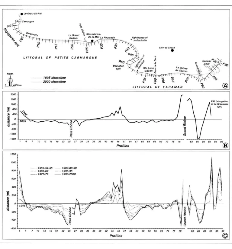
the end of the 18th century are highly reliable. Initiated by the engineer Charles François Beautemps-Beaupré, these measurements were taken by triangulation using a theodol ite coupled to a hydrographie circle. Positioning is carried out from landmarks materialised by beacons installed on firm ground. The measuring precision is estimated at ± 10 m. Fig. 5 - Shoreline changes between 1895 and 2000. A: position of profiles; B: shoreline changes between 1895 and 1944; C: shoreline changes between 1 944 and 2000.
Fig. 5 - Variations du trait de côte entre 1895 et 2000. A : position des profils ; B: variations du trait de côte entre 1895 et 1944; C: varia tions du trait de côte entre 1944 et 2000.
For the surveys carried out by DGPS in 2000, the planime- tric error margin for the coastline position in 2000 is close to ± 3 m.
Results
Changes of shoreline position
The variations of the coastline are analysed from 98 pro files drawn perpendicular to the shore (fig. 5A).
The most important shoreline changes along the Rhône delta coast are in the vicinity of the mouth of the Grand Rhône, with the construction of La Gracieuse spit during the ф Le Grau-du-Rol
LITTORAL OF PETITE CARMARGUE
1 4 7 10 13 16 19 22 25 27 30 33 36 42 45 48 51 54 57 60 63
Profiles 92 95 98
1 4 7 10 13 16 19 22 25 27 30 33 36 39 42 45 48 51 54 57 60 63 66
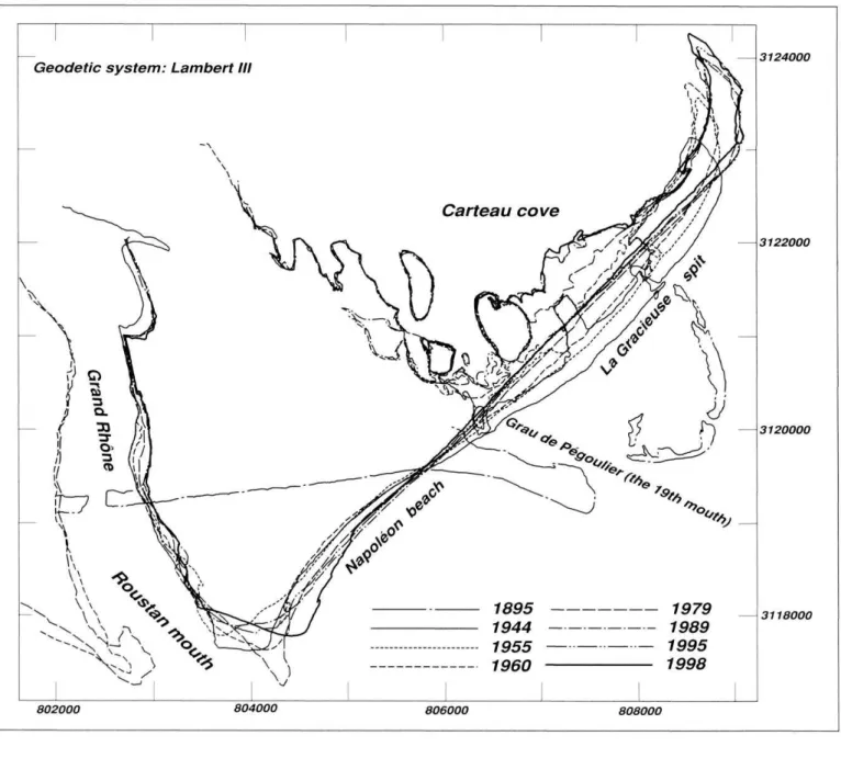
Evolution of the Rhône delta coast since the end of the 19th century 20th century. After the Rhône mouth switched from Pégou-
lier to Roustan in 1892, the massive destruction of the pro- deltaic lobe of Pégoulier induced a shoreline retreat of about 1,500 m between 1895 and 1944 (fig. 5B). Meanwhile Gra cieuse spit became elongated to the northeast, growing by 1,400 m until 1944 (fig. 6). At the same time, Piémanson and Napoléon beaches, located on either site of the mouth, underwent rapid progradation, of the order of 1,500 m and 1,700 m respectively. From 1944 to 1998, Gracieuse spit lengthened by a further 1,200 m, but its central part expe rienced a retreat of about 400 m, while Napoléon beach pro- graded about 120 m (fig. 5C).
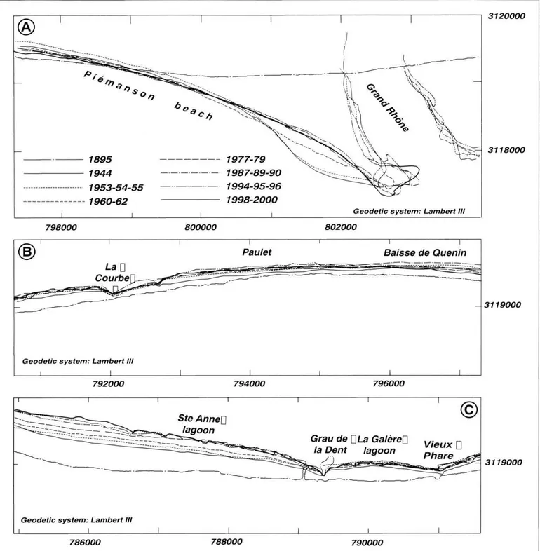
To the west of the mouth of the Grand Rhône, the Fara- man shoreline exhibits two sectors marked by different pat terns of evolution (fig. 7). Between 1895 and 1960-1962, Piémanson beach (profiles P77 to P74) is subject to erosion (fig. 7A). The rather slow rates of retreat oscillate between -1 and -15 m/yr according to the sector and period. After the 1960s, the trend is reversed. The régularisation of the coast line towards a rectilinear shape is due to the progradation
processes with rates ranging between +2 and +7 m/yr. Gener ally speaking, profile 74 corresponds to a hinge point, after which is observed a transition into a zone of constant ero sion since 1895. This zone extends from Baisse de Quenin to Beauduc light house (fig. 7B). To the east of Grau de la Dent (P75 to P60), erosion rates are between -2 and -3 m/yr over the whole of the period, corresponding to a maximum secular retreat of -250 m in the western sector of Baisse de Quenin (P70-P71). To the west of Grau de la Dent (fig. 7C), the erosion of the shoreline is more rapid, with rates of be tween -2 and -8 m/yr over the whole of the period. Maximum erosion is recorded at profile 54, where the beach has moved back by approximately 650 m since 1895.
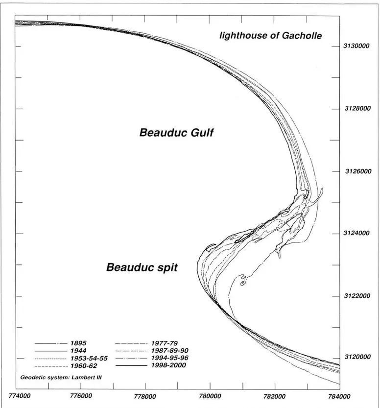
The spit and gulf of Beauduc have been subject to import ant sedimentation (P51 to P35). There has been a secular
Fig. 6 - Shoreline changes of La Gracieuse spit and Napoléon beach between 1895 and 1998.
Fig. 6 - Variations du trait de côte de la flèche de la Gracieuse et de la plage Napoléon entre 1895 et 1998.
Geodetic system: Lambert III
v 1895 1979 1944 1989 1955 1995 1960 1998 3124000 3122000 3120000 3118000 802000 804000 806000 808000
1895 1977-79
1944 1987-89-90
1953-54-55 1994-95-96 1960-62 1998-2000
i i i__ Geodetic system: Lambert III
3120000
3118000
798000 800000 802000
ii
Baisse de Quenin
Geodetic system: Lambert III
3119000
792000 794000 796000
Grau de ULa GalèreU la Dent lagoon
Geodetic system: Lambert III
i i
3119000
786000 788000 790000
advance of the shoreline of approximately +1,500 m on the axis of Beauduc spit (P50) (fig. 8). These very high rates of progradation vary between +7 and +15 m/yr at the spit, but are lower in the gulf, with values between +1 and +6 m/yr.
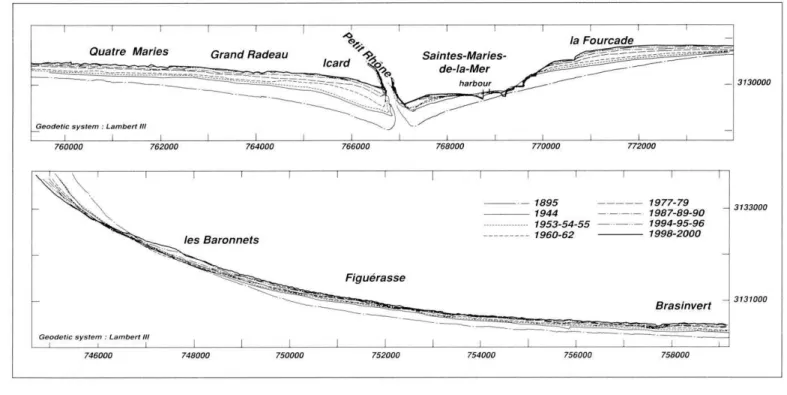
From the lighthouse of La Gacholle to Baronnets, the coast of Saintes-Maries-de-la-Mer and Petite Camargue has been in constant erosion since 1895 (figs. 9A and 9B). This area is subject to considerable coastal retreat that threatens the socio-economic activities situated behind the shoreline, and has undergone the most extensive development of arti ficial environments in the delta since the 1980s (photos 4 and 5). From the lighthouse of Gacholle to the eastern part of the village of Saintes-Maries-de-la-Mer, the rates of coas-
Fig. 7 - Shoreline changes on the littoral of Faraman between 1895 and 2000.
Fig. 7 - Variations du trait de côte du littoral de Faraman entre 1895 et 2000.
tal erosion increase, with values ranging from -1 m/yr in the east to -5 m/yr in the sector of La Fourcade where the coast line has moved back more than 500 m since 1895 (P30). The pattern of variation shows that the retreat remained around -3 m/yr between 1895 and the 1960s, and then accelerated to -5 m/yr from 1963 onwards. The shoreline of the village of Saintes-Maries-de-la-Mer initially underwent the same evo lution. However, the trend is reversed from the 1970s on- 292 Géomorphologie : relief, processus, environnement, 2003, n° 4, p. 283-300
Evolution of the Rhône delta coast since the end of the 19th century lighthouse of Gacholle Beauduc Gulf Beauduc spit — 1895 1944 1953-54-55 1977-79 1987-89-90 1994-95-96 1998-2000 Geodetic system: Lambert III
III — 3130000 — 3128000 — 3126000 — 3124000 — 3122000 774000 776000 778000 780000 782000 _ 3120000 784000 wards as coastal defences were emplaced (photo 5). The
coastline near the mouth of the Petit Rhône (P25 to P21) shows the maximum amount of retreat observed in the Rhône delta since 1895. It reaches more than 1,000 m at the level of profile 25, with rates ranging between -3.5 and -10 m/yr according to the sector. This erosive trend conti nues towards the west, between the sectors of Grand Radeau and Baronnets (P20 to P6), but the rate of retreat gradually decreases to between -1 and -4 m/yr. For the entire coast west of the mouth of the Petit Rhône, however, the retreat is slower from the 1980s onwards.
Fig. 8 - Shoreline changes on the spit and gulf of Beauduc be tween 1895 and 2000.
Fig. 8 - Variations du trait de côte du littoral de la flèche et du golfe de Beauduc entre 1895 et 2000.
As observed in the case of the Beauduc spit, the Espi- guette spit (P5 to PI) is marked by a constant progradation of the coast (fig. 10). In this sector, we find the highest values of coastline advance (+1,500 m at profile PI) on the scale of the entire delta.
Spatial variations in coastal surface area and sediment budget
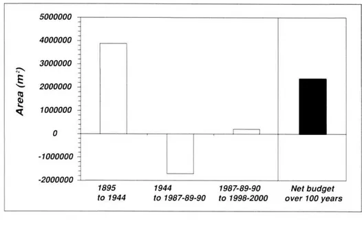
The evolution of the surface area in different sectors confirms the results obtained on coastline changes. The secular evolution of land areas gained or lost on the littoral fringe enables identification of three periods (fig. 11). The Camargue coast records a gain of 3,875,600 m2 between 1895 and 1944, a loss of 1,707,800 m2 between 1944 and 1987-1990, and a gain of 209,600 m2 between 1987-1990 and 1998-2000. The surface area determined over the scale of the century thus shows a net gain of about 2,377,400 m2.
Five zones exhibit a rather homogeneous behaviour irre spective of the period (fig. 12). Espiguette spit and the Beau- due sector have increased by 46,500 and 66,000 m2/yr, res pectively (average values calculated for the whole century). On the contrary, a continuous surface area loss is recorded in the sectors located west of Grau de la Dent, from La Gacholle to the Petit Rhône and from the Petit Rhône to Baronnets, with average values of -33,000 m2/yr, -69,000 m2/yr and -30,000 m2/yr, respectively. The four zones loca ted on either side of the mouth of the Grand Rhône (fig. 12) show a more irregular behaviour marked by periods of gain or retreat.
Discussion
Efficiency of coastal defence structures in maintaining shoreline position
The artificial dune built inl988 to stabilise the central part of Gracieuse spit and the barges stranded at the end of the spit presently control the general shape of this feature. Along Faraman shore, the coastline was stabilised at the end of the 1980s (period 1989-1990). This change of behaviour is explained by the emplacement, from 1987 onwards, of
hard coastal defence structures constructed by the Compag nie des Salins du Midi et des Salines de l'Est (photo 3). While this policy of coastline stabilisation proved satisfac tory (Suanez et Bruzzi, 1999), other poorly protected sectors retreated again after 1992. The coastal structures along the village of Saintes-Maries-de-la-Mer have stabilised the sho reline since the 1970s but induced erosion on the eastern part since the 1960s (La Fourcade). In this case, the coastal structures trap sediment transported by longshore currents from west to east and thus starve la Fourcade beach which erodes. Along the Petite Camargue, the field groynes (photo 5) built in 1975 and 1984-86 reduced shoreline retreat but these structures have yielded less satisfactory results than along Faraman shore. Two factors explain these results. First, the spacing between groynes along the Petite Camargue is probably too large (Sabatier, 2001) and second, the Faraman coast receives more sediment because of the proximity of the fossil sub-delta of Bras de Fer whose ero sion sources the surf zone (Suanez et Bruzzi, 1999). On Espiguette spit, sedimentation became all the more import ant during the 1970s, when a dyke was built at the end of the spit to block longshore sediment transport. It was constructed to prevent silting up of the entrance to Port Camargue marina. Since the end of the 1990s, this dyke is gradually bypassed by sand due to shoreline advance (photo 6). In general, the coastal structures enable fixing of the shoreline position or reduction of shoreline retreat but submarine erosion continues. The long term efficiency of these structures is thus not clear (Paskoff, 1998; Sabatier and Provansal, 2000, 2002).
Fig. 9 - Shoreline changes on the littoral of Saintes-Maries-de- la-Mer and the Petite Camargue between 1895 and 2000. Fig. 9 - Variations du trait de côte du littoral des Saintes-Maries- de-la-Mer et de la Petite Camargue entre 1895 et 2000.
Saintes-Maries- de-la-Mer
harbour Geodetic system : Lambert III I I
762000 1977-79 1987-89-90 1953-54-55 1994-95-96 1960-62 1998-2000 — 1895 — 1944
Geodetic system : Lambert III
758000 294 Géomorphologie : relief, processus, environnement, 2003, n° 4, p. 283-300
Evolution of the Rhône delta coast since the end of the 19th century 1 Рог, Camargue^ J/ / \- \ \ \ 1 / - \\ \i Espiguett^Á \\\ sp/ř \\\\ \'\ —
Geodetic system : Lambert III
1 744000 у?У I/I C% À ' ///?JjN I *'Xy 7 I m / - / A \ lighthouse of ^\\ \ Espiguette 746000 1QAA 1953-54-55 1960-62 1977-79 1987-89-90 1994-95-96 1QQR-2OOO . I 3137000 3135000 3133000 748000 River sediment contribution to the
shoreline position
Along the whole delta coast, the large increase in land area recorded between 1895 and 1944 (fig. 11) can be explained by an abundant supply of sediment to the coast. In spite of the relative reduction in the frequency of annual floods (Pichard, 1995), the persistence of mountain agricul tural land use and incomplete reforestation in the catchment basin accounted for the continuing
abundance of solid load before the era of hydroelectric dams. After 1944, the agricultural decline acce lerated and the vegetation cover of the Rhône catchment became more extensive, particularly near the banks, where riverine plants effecti vely trap sands and silts (Bravard, 1989; Jorda and Provansal, 1996; Miramont and Guilbert, 1997; Pié-
Fig. 10 - Shoreline changes on Espiguette spit between 1895 and 2000.
Fig. 10 - Variations du trait de côte de la flèche de l'Espiguette entre 1895 et 2000.
gay et al, 1997; Warner, 2000). The reduction in the area of bare soil involved a decrease in the sediment supply, which became even more marked in the years 1950-1960 due to the construction of hydroelectric dams that blocked much of the coarse load of the watercourses (Klingeman et al, 1994; Gaut ier, 1994; 1RS, 2001). This phenomenon was accentuated by the decline in river liquid discharge during these decades and the decreased frequency of floods (Pichard, 1995; Anto- nelli, 2002; Pont et al, 2002; Arnaud-Fassetta 2003). These factors explain the reversal of the trend observed between 1944 and the late 1980s. During this period, the coastal fringe of the Rhône delta underwent a deficit in sediment input that resulted in shoreline erosion and in a loss of surface area. The increase in surface area recorded on the Camargue coastal fringe between 1987- 1990 and 1998-2000 demonstrates the effectiveness of coast al defence structures in slowing down coastline retreat as discussed above.
River sediment contribution to the shoreline is highlighted in figure 12. The chaotic-type behaviour of sectors close to the mouth of the Grand Rhône (fig. 12) is explained by the
Fig. 1 1 - Secular evolution of the sur face area of different homogeneous
sectors.
Fig. 11 - Evolution séculaire des varia tions de surface de la frange littorale par secteurs homogènes.
4000000 - 3000000 2000000 '- 1000000 '- -1000000 -2000000 1895
to 1944 1944to 1987-89-90 to 1998-2000 1987-89-90 over 100 years Net budget Géomorphologie : relief, processus, environnement, 2003, n° 4, p. 283-300 295
Espiguette spit from Baronnets to the Petit Rhône from the Petit Rhône
to La Gacholle gulf and spit
ofBeauduc west of Grau de la Dent (Beauduc and Ste Anne lagoons) east of Grau de la Dent
(La Galère lagoon + Baisse de Quenin + Piémanson beach) western part of the Grand Rhône mouth eastern part of the Grand Rhône mouth east of the Grand Rhône (Napoléon beach and La
Gracieuse spit) ■ 1994-95-96/1998-2000 ■ 1987-89-90/1994-95-96 ■ 1977-79/1987-89-90 ■ 1960-62/1977-79 ■ 1953-54-55/1960-62 □ 1944/1953-54-55 □ 1895/1944 GAIN -100000 -50000 0 Surface in m2/yr I 50000 100000 I 150000 I strong interannual variability of the sediment input from the
river. The redistribution of these sediments by longshore drift, after temporary storage in the vicinity of the mouth, is probably offset in time from one sector to another. However, with increasing distance from the mouth of the Grand Rhône (fig. 12), the continuous development of sectors in erosion and accretion suggests that longshore drift assumes greater importance. A number of permanent zones can thus be di stinguished wherein sediment erosion is predominant (west of Grau de la Dent, from the Petit Rhône to Baronnets and from Gacholle to the Petit Rhône), in contrast with zones where deposition is predominant (Espiguette spit and the Beauduc sector). This distribution indicates an organisation of the Rhône delta shoreline based on longshore drift cells.
Longshore drift cells
The longshore drift pattern is based on the identification of four cells, each of which is defined by an accretion zone (spits, gulf and Roustan mouth) supplied by a zone under going erosion (May and Tanner, 1973; Stapor, 1974; Carter, 1988; Komar, 1998). While longshore sediment transport is the major process reshaping the Rhône delta coastline,
Fig. 1 2 - Secular evolution of the surface area of the Rhône delta coastal fringe.
Fig. 12 - Évolution séculaire de la frange littorale du delta du Rhône exprimée en surface.
cross-shore processes also exist, but these cannot be quanti fied using shoreline change analysis. The cell definition pat tern presented here is based on the pattern of evolution of the Rhône delta. However, it is confirmed by simulations of longshore sediment transport using empirical equations (Sogreah, 1995).
The easternmost cell (CEL1) is located east of the Grand Rhône, where the prevailing sediment transport is eastward (fig. 13). It is bounded on its western side by the mouth of the Rhône, and on its eastern side by the La Gracieuse spit. This cell is thus fed by the present-day inputs of the Rhône (active source) and by the erosion of the fossil deltaic lobe of Pégoulier (Suanez, 1997; Suanez et al., 1998).
The second cell (CEL2) also shows a general direction of transport from west to east, and extends from Ste-Anne lagoon as far as Grau de Roustan (fig. 13). Although the shoreline retreat in this zone contributes to the supply to Pi émanson beach, part of the eroded material is stored in the 296 Géomorphologie : relief, processus, environnement, 2003, n° 4, p. 283-300
Evolution of the Rhône delta coast since the end of the 1 9th century
CEL4 erosion
accretion
dominant longshore sediment transport
Fossil sub-delta of Pégoulier CEL1 CEL2
vicinity of the Roustan prodelta, considered as an important sediment sink (Suanez et al, 1998) The limit between cells 2 and 3, located generally near Ste Anne lagoon, is explai ned by a reversal of the longshore drift along with sediment transport as a result of refraction of swell on the fossil del taic lobe of the Bras de Fer (Sabatier, 2001).
The third cell 3 (CEL3) extends from Ste Anne lagoon in the east as far as the Petit Rhône in the west (fig. 13). This cell is made up of a central part subject to accumulation (spit and gulf of Beauduc), fed in the east by the retreat of the beaches and erosion of the fossil sub-delta of the Bras de Fer, and in the west by erosion of the beaches in the Saintes- Maries-de-la-Мег sector. Thus, drift convergence associated with the two eroded sectors results in an important sediment sink in the very centre of the delta. Sediment supply to Gulf of Beauduc via the Petit Rhône is extremely limited, being dependent on the very weak sand inputs of this arm (Arnaud- Fassetta, 1996, 1997; Arnaud-Fassetta et al, 2003).
To the west of the Petit Rhône, the fourth cell (CEL4) is defined by a dominant sediment transport directed towards Espiguette spit (fig. 13). As seen on the littoral of Faraman, the opposite sediment transport directions in cells 3 and 4 can be explained by the divergence of the longshore drift related to refraction of swell on the prodelta of the Petit Rhône (Sogreah, 1995; Sabatier, 2001). The sector in ero sion from the Petit Rhône to Baronnets contributes to sandy inputs to the spit, which may also be considered as a sand sink (Blanc, 1977; Sabatier and Raivard, 2002).
Conclusion
This study updates our knowledge of the changes that have affected the Rhône delta coastline over the past 105 years. The use of digital processing techniques has been in strumental in integrating and managing, via a Geographic Information System, the large database compiled from the analysis of various sources. The results of this work enable the drawing up of maps aimed at the prevention of erosion risks, and the proposal of these tools as aids to decision- making in coastal management.
Fig. 13 - The littoral cell pattern on the Rhône delta coast. Fig. 13- Organisation des cellules littorales le long du delta du Rhône.
These results also show the close link between the Rhône catchment area and the littoral fringe of the Rhône delta. The secular evolution of the coastline near the mouth clearly records variations in fluvial sediment input, but it remains difficult to separate the effects of hydrological changes (end of the Little Ice Age) from modifications due to changing land use or hydraulic engineering works. The beaches close to the Grand Rhône mouth are dependent on the river sed iment input but the erosion of fossil sub-deltas plays also an important role in feeding the spits.
Finally, the results highlight the important role played by coastal defence structures in the current dynamic status of large parts of the coastline. These has been a heated debate about their long-term effectiveness, especially in view of the forecasts of sea-level rise and the poorly known long-term evolution of the submerged shoreface profile (Suanez and Provansal, 1996; Paskoff, 1998, 2001; Suanez and Sabatier, 1999; Provansal and Sabatier, 2000; Picon and Provansal, 2002). In such a context, several stake-holders in coastal ma nagement have put forward the idea of a strategic withdrawal of activities and settlement assets in certain sectors (Conserv atoire du Littoral, Parc de la Camargue, Réserve Nationale de Camargue). This position is evidently badly accepted by the local residents and inhabitants of Saintes-Maries-de-la- Mer, and by the salt extraction industry and farmers of the Petite Camargue. The pursuit of scientific monitoring and analysis should enable politicians and managers to make de cisions with a fuller knowledge of the coastal processes. Acknowledgements
The research reported in this paper was carried out as part ofEURODELJA program supported by the European Union (contract EVK3-CT2001 -20001 EURODELTA) and the French program ORME. This work is also part of the PhD. dissertation ofF. Sabatier supported by the Compagnie des Salins du Midi et des Salines de l'Est and Region Provence- Géomorphologie : relief, processus, environnement, 2003, n° 4, p. 283-300 297
Alpes-Côte-d'Azur. The authors wish to thank EPSHOM for permission to use the 1895 shoreline position. Particular thanks are due to members of CEREGE laboratory: Pr. M. Provansal whose suggestions have helped to improve the paper, Dr. B. Simon for assistance in aerial photograph anal
ysis and Dr. C. Vella for his help in the field during the acquisition of data on shoreline acquisition using DGPS. We also thank the anonymous reviewers, J.C. Thouret and more particularly E. Anthony for their comments which improved
the manuscript. References
Antonelli C. (2002) -Flux sédimentaires et morphogenèse récente dans le chenal du Rhône aval. Thèse de Doctorat, université de Provence, Aix -Marseille I, 279 p.
Antonelli C, Provansal M. (2002) - Vers une ré-évaluation des matières en suspension du Rhône aval par acquisition de mesures sur toute la colonne d'eau. Proceedings of Geomorphology: from expert opinion to modelling, Strasbourg, France, 141-148. Arnaud-Fassetta G. (1996) - Les inondites rhodaniennes d'oc
tobre 1993 et janvier 1994 en milieu fluvio-deltaïque. L'exemple du Petit Rhône. Quaternaire, 7 (2-3), 139-153.
Arnaud-Fassetta G. (1997) - Évolution du plancher alluvial du Petit Rhône à l'échelle pluri-annuelle (delta du Rhône, France du Sud). Géomorphologie : relief, processus, environnement, 3, 237-256.
Arnaud-Fassetta G. (1998) - Dynamiques fluviales holocènes dans le delta du Rhône. Thèse de Doctorat, université de Pro vence, Aix-Marseille I, 328 p.
Arnaud-Fassetta G. (2003) - River channel changes in the Rhône Delta (France) since the end of the Little Ice Âge: geomorpho- logical adjustment to hydroclimatic change and natural resource management. Catena, 51 (2), 141-172.
Arnaud-Fassetta G., Quisserne D., Antonelli C. (2003) - Downstream grain-size distribution of superficial bed material and its hydro-geomorphological significance in a large and regu lated river: the Rhône River in its delta area (France). Géomorp hologie : relief, processus, environnement, l, 33-50.
Blanc J.-J. (1977) - Recherches de sédimentologie appliquée au littoral du delta du Rhône, de Fos au Grau-du-Roi. CNEXO, 75/1193, 69 p.
Bravard J.-P. (1989) - La métamorphose des rivières des Alpes françaises à la fin du Moyen-Âge et à l'époque moderne. Bullet in de la Société Géographique de Liège, 25, 145-157.
Caillaud A., Boudet G., Gieulles D., Briand O. (1990) - Le li ttoral de Salin-de-Giraud (Commune d'Arles), évolution et pr ogramme de travaux de stabilisation. Comptes rendus du Premier Symposium International de l'Association Européenne, EURO- COAST, Marseille 9-13 juillet 1990, 729-733.
Carter R.W.G. (1988) - Coastal Environments. Academic Press, Londres, 617 p.
Crowell M., Leatherman S.P., Buckley M.K. (1991) - Historical shoreline change: error analysis and mapping accuracy. Journal of Coastal Research, 7 (3), 839-852.
Dolan R., Hayden В., Heywood J. (1978) - A new photogram- metric method for determining shoreline erosion. Coastal Engi neering, 2, 21-39.
Duboul-Razavet C. (1956) - Contribution à l'étude géologique et sédimentologique du delta du Rhône. Mémoire de la Société Géologique de France, 76, 234 p.
Durand P. (1998) - Cinématique d'un littoral sableux à partir de photographies aériennes et de cartes topographiques. Exemple du littoral d'Argelès-Plage à Saint-Cyprien (Rous- sillon, France). Géomorphologie : relief, processus, environne ment, 2, 155-166.
Durand P. (2000) - Approche méthodologique pour l'analyse de l'évolution des littoraux sableux par photo-interprétation. Exemple des plages situées entre les embouchures de l'Aude et de l'Hérault (Languedoc, France). Photo-Interprétation, 1/2, 3-17.
Galloway W.E. (1975) - Process framework for describing the morphologic and stratigraphie evolution of deltaic depositional systems. In Brousard M. L. (Ed.) : Deltas, models for explorat ion. Houston Geology Society, 87-98.
Gautier E. (1994) - Interférences des facteurs anthropiques et naturels dans le processus d'incision sur une rivière alpine. L'exemple du Buëch, Alpes du Sud. Revue de Géographie de Lyon, 61 (1), 57-62.
Greslou M. (1984) - Catalogue sédimentologique des côtes fran çaises. Côte de la Méditerranée de la frontière espagnole à la frontière italienne. Partie В : de Sète à Marseille. Collection Direction des Études et Recherches d'EDF, Eyrolles, 106-187. Institut Rhône Saône (1RS) (2001) - Étude globale pour une
stratégie de réduction des risques dus aux crues du Rhône. Étude du transport solide. V" étape, rapport de synthèse, Insti tution interdépartementale des bassins Rhône-Saône, Valence, France, 5 vol., 469 p.
Jimenez J-A., Sanchez-Arcilla A., Bou J., Ortiz MA. (1997) - Analysing short-term shoreline changes along the Ebro delta using aerial photographs. Journal of Coastal Research, 13 (4), 1256-1266.
Jorda M., Provansal M. (1996) - Impact de l'anthropisation et du climat sur le détritisme en France du sud-est (Alpes du Sud et Provence). Bulletin de la Société Géologique de France, 167 (1), 159-168.
Juniet F. (1962) - Littoral de Camargue de la pointe de Beauduc au golfe de Fos. Évolution des profondeurs de 1959 à 1962 et orientation des études à venir. Ponts et Chaussées, Service Mari time des Bouches -du-Rhône, 92 p.
Klingeman C, Bravard J.-P., Giuliani Y. (1994) - Les impacts morphodynamiques sur un cours d'eau soumis à un aménage ment hydroélectrique à dérivation : le Rhône en Chautagne (France). Revue de Géographie de Lyon, 69 (1), 63-72. Komar P.D. (1998) - Beach Processes and Sedimentation. 2nd éd.,
Prentice Hall, 544 p.
Kruit C. (1955) - Sediments of the Rhône delta. Grain size and Microfauna. Verhandelingen van het Koninklijk Mijnbouwkun- dig Genootschap. Geologische série deel 15, 359-501.
Levoy F. (1989) - Morpho-cinématique et évolution récente prévi sionnelle du rivage de Montmartin-sur-Mer. Photo-Interprétat ion, 1, 1-5.
L'Homer A. (1992) - Sea-level changes and impacts on the Rhône delta coastal lowlands. In Tooley M.J., Jelgersma S. (Eds.): Impacts of sea-level rise on European coastal lowlands. Black-
well, 136-152.
Evolution of the Rhône delta coast since the end of the 1 9th century L'Homer A., Bazile F., Thommeret J., Thommeret Y. (1981) -
Principales étapes de l'édification du delta du Rhône de 7000 BP à nos jours ; variation du niveau marin. OCEANIS, 1 (4), 389-408.
Longé J.P. (1990) - Rehabilitation of "la flèche de la Gracieuse". Comptes rendus du Premier Symposium International de l'Asso ciation Européenne, EUROCOAST, Marseille 9-13 juillet 1990, 719-723.
May J.P., Tanner W. F. (1973) - The littoral drift power gradient and shorelines change. In Coates D. R. (Ed.): Coastal Geomor- phology. University of New York, 43-60.
Miramont C, Guilbert X. (1997) - Variations historiques de la fréquence des crues et évolution de la morphogénèse fluviale en moyenne Durance (France, S-E). Géomorphologie : relief, pro cessus, environnement, 4, 325-338.
Pardé M. (1925) - Le régime du Rhône. Étude hydrologique. Pre mière partie, Étude générale. Institut des études rhodaniennes, université de Lyon. Masson, Paris, 883 p.
Paskoff R. (1994) - La cartographie prospective de l'évolution du trait de côte : un instrument indispensable pour l'aménagement des espaces littoraux. Cahiers Nantais, 41/42, 291-297. Paskoff R. (1998) - La mer envahit la Petite Camargue, pourquoi
ne pas la laisser faire ? Pour la Science, 247, p. 16.
Paskoff R. (2001) - L 'élévation du niveau de la mer et les espaces côtiers. Institut océanographique, Paris, 190 p.
Pichard G. (1995) - Les crues sur le bas Rhône de 1500 à nos jours. Pour une histoire hydro-climatique. Méditerranée, 3 (4),
105-116.
Picon В., Provansal M. (2002) - Faut-il se protéger de la mer ? Instabilités naturelles et politiques publiques dans le delta du Rhône. Faire Savoirs, Marseille, 2, 75-80.
Piégay H., Landon N., Bravard J.-P., Clément P., Liébault F. (1997) - Channel incision and potentiality of reversibility: the Drome river case, France. Proceedings of the conference on management of landscapes disturbed by channel incision, 20-22 May 1997, Oxford, Mississipi, USA, 53-59.
Pons A., Toni C, Triat-Laval H. (1979) - Édification de la Camargue et histoire holocène de sa végétation. Terre et Vie, Revue d'Ecologie, Marseille, suppl. 2, 13-30.
Pont D., Simonnet J.P., Walter A.V. (2002) - Medium-term changes in suspended sediment delivery to the ocean: conse quences of catchment heterogeneity and river management (Rhône river, France). Estuarine, Coastal and Shelf Science, 54, 1-18.
Provansal M., Sabatier F. (2000) - Impact de la montée du niveau de la mer sur la côte du delta du Rhône. In "Le changement cl imatique et les espaces côtiers. L'élévation du niveau de la mer : risques et réponses". Colloque proposé par la mission intermin istérielle de l'effet de serre, région PACA et DATAR, 12-14 octobre 2001, Arles, 78-81.
Provansal M., Vella C, Arnaud-Fassetta G., Sabatier F., Maillet G. (2003) - Role of sedimentary fluvial inputs in the mobility of the Rhône delta coast (France). Géomorphologie : relief, processus, environnement, 4, 271-282.
Robin M. (2002) - Télédétection et modélisation du trait de côte et de sa cinématique. In Baron- Yelles N. et al. (Ed.) : Le littoral, regards, pratiques et savoirs. Presses de l'École normale supér ieure, Paris, 95-115.
Sabatier F. (2001) - Fonctionnement et dynamiques morphosédi- mentaires du littoral du delta du Rhône. Thèse de Doctorat, uni versité d'Aix-Marseille III, 272 p.
Sabatier F., Provansal M. (2000) - Bilans morphologiques, répar tition granulométrique et direction du transport sédimentaire autour du brise-lames de Ste Anne, delta du Rhône. Génie Civil Génie Côtier, Caen, 207-216.
Sabatier F., Provansal M. (2002) - La Camargue sera-t-elle sub mergée ? La Recherche, juillet-août 2002, 72-73.
Sabatier F., Raivard L. (2002) - Évolution bathymétrique de la pointe de l'Espiguette (delta du Rhône, mer Méditerranée) : résultats préliminaires. Actes du Colloque "Espaces littoraux en mutation", Commission Nationale de Géographie de la Mer, Dunkerque, 3-5 juin 2000, 101-105.
Shoshany M., Degani A. (1992) - Shoreline detection by digital image processing of aerial photography. Journal of Coastal Research, 8 (1), 29-34.
Sogreah (1995) - Étude de l'évolution du littoral sableux de la Camargue, 2 tomes, Grenoble.
Sogreah (1999) - Aqueduc du Rhône à Barcelone, investigations supplémentaires. RMC8, Impacts sur les sédiments du Rhône.
Rapport 55 0470/JLR/R3 VA, Grenoble, 82 p.
Stapor F. W. (1974) - The "cell" concept in coastal geology. In Tanner W. F. (Ed.): Sediment transport in the near shore zone. Florida State University, 1-11.
Suanez S. (1997) - Dynamiques sédimentaires actuelles et récentes de la frange littorale orientale du delta du Rhône. Thèse de doctorat, université de Provence, Aix-Marseille I, 283 p.
Suanez S., Bruzzi C. (1999) - Shoreline management and its implications for the coastal processes on the eastern part of the Rhône delta. Journal of Coastal Conservation, 5, 1-12. Suanez S., Bruzzi C, Arnoux-Chiavassa S. (1998) - Données
récentes sur l'évolution des fonds marins dans le secteur orient al du delta du Rhône (plage Napoléon et flèche de la Gra cieuse). Géomorphologie : relief, processus, environnement, 4, 291-312.
Suanez S., Provansal M. (1996) - Morphosedimentary beha viour of the deltaic fringe in comparison to the relative sea- level rise on the Rhône delta. Quaternary Science Reviews, 15, 811-818.
Suanez S., Provansal M. (1998) - Large scale evolution of the li ttoral of the Rhône delta (Southeast France). Journal of Coastal Research, 14 (2), 493-501.
Suanez S., Sabatier F. (1999) - Eléments de réflexion pour une gestion plus cohérente d'un système anthropisé : exemple du li ttoral du delta du Rhône. Revue de Géographie de Lyon, 74 (1), 7-25.
Suanez S., Simon B. (1997) - Utilisation de l'analyse dia- chronique dans l'étude de l'évolution du littoral du delta du Rhône (France, Sud-Est). Photo-Interprétation, 35, 3/4, 147-158.
Triat-Laval H. (1978) - Contribution pollenanalytique à l'histoire tardi et postglaciaire de la végétation de la basse vallée du Rhône. Thèse de l'université d'Aix-Marseille III, 344 p. Vella C, Provansal M. (2000) - Relative sea-level rise and neo-
tectonic events during the last 6,500 yr on the Southern eastern Rhône delta, France. Marine Geology, 170, 27-39.
Vella C. (2002) - Évolution paléogéographique du littoral de Fos Warner R.F. (2000) - Gross channel change along the Durance et du delta du Rhône : implications archéologiques. In Rivet L. river, southern France, over the last 100 years using cartogra- and Sciallano M. (Ed.) : Vivre, produire et échanger : reflets phic data. Regulated river: research and management, 16, méditerranéens. M. Mergoil, Montagnac, 103-114. 141-157.
Vernier E. (1976) - Édification et évolution de la flèche de Gracieuse
(ouest du golfe de Fos). Bulletin du B.R.G.M., Section IV, 2, 103-115. Article reçu le 21 mars 2003, accepté le 19 novembre 2003