is an open access repository that collects the work of Arts et Métiers Institute of
Technology researchers and makes it freely available over the web where possible.
This is an author-deposited version published in: https://sam.ensam.eu Handle ID: .http://hdl.handle.net/10985/9776
To cite this version :
Chiara STEFANI, Livio DE LUCA, Philippe VERON, Michel FLORENZANO - Modeling buildings historical evolutions - In: Proceedings of Focus K3D conference on Semantic 3D Media and Content, France, 2010 - Proceedings of Focus K3D conference on Semantic 3D Media and Content - 2010
Any correspondence concerning this service should be sent to the repository Administrator : [email protected]
Abstract—. Various aspects condition the analysis and the interpretation of cultural heritage. In fact, historical sites can have a rich and complex history, sometimes full of changes, sometimes only partially known by means of documentary sources. This paper proposes a hibrid approach on one hand to structure and organize building entities, and on the other one to represent evolution and uncertainty around buildings.
Index Terms— Spatio-temporal modeling, temporal changes, uncertainty, historic graphs.
I. INTRODUCTION
OWADAYS computer graphic techniques become increasingly necessary on one hand to display and verify historical site analysis and on the other one to describe, to comprehend and to support historical heritage.
For instance, spatial data issued from laser scanner combined with photogrammetric and topography concepts [1] is interpreted to generate relevant and precise spatial representations. These techniques enable to show architectural objects at various levels of detail in accordance to the different purposes of the morphological analysis [2].
In this rather promising panorama, however, it is important to highlight a fallacy: even if 3D reconstructions allow dimensional information of artifact current states to be processed and rendered by means of new measuring devices and digital technology, representation and management of missing and past states open various problems.
Three main factors affect the display of past states. Firstly, restitutions in archaeology and architecture are generally connected only to one historical state that usually is the period of higher luster of a building and not his state of corruption. As shown by a lot of researches, buildings are too often
C. Stefani is with the UMR CNRS/MCC 694 MAP - Modèles et simulations pour l'Architecture, l'Urbanisme et le Paysage, ENSA Marseille, 184, Av. de Luminy, 13288 Marseille Cedex 9, France (corresponding author to provide phone: +33(0)4 91827170; fax: +33(0)4 91827171; e-mail: [email protected]).
L. De Luca is with the UMR CNRS/MCC 694 MAP - Modèles et simulations pour l'Architecture, l'Urbanisme et le Paysage, ENSA Marseille, 184, Av. de Luminy, 13288 Marseille Cedex 9, France (e-mail: [email protected]).
P. Véron is with the LSIS - UMR CNRS 6168, CER ENSAM, 2, cours des Arts et Métiers, 13617 Aix-en-Provence Cedex 1, France (e-mail: [email protected]).
M. Florenzano is the Director of the UMR CNRS/MCC 694 MAP - Modèles et simulations pour l'Architecture, l'Urbanisme et le Paysage, ENSA Marseille, 184, Av. de Luminy, 13288 Marseille Cedex 9, France (e-mail: [email protected]).
considered as static and unchangeable entities [3]. As a matter of fact, buildings are not inexorably constant in time, but, rather, in continuous change. As a consequence, they must be considered as dynamics entities. Secondly, when studying historic buildings, generally the more we go back in time, fewer documents are accurate and assumptions become multiple and sometimes contradictory. As a consequence, the digital model should highlight all the contradictions and lacks of information related to the morphological restitution. Thirdly, according to the level of knowledge offered by documentary sources, multiple restitutions over time are possible.
A. State of the art
Today modeling software enables users to obtain particularly rich and complex geometries with a high level of detail which lead us to think that architectures are always described in a correct, objective and complete way.
Some recent works offer historic restitutions of sites in their best state, without giving information neither on their physical position nor on what has been really preserved [3],[4]. Relevance of information is not precisely stated: restitutions do not seem to be related to a specific stage of the morphological evolution of buildings. Historical state are so detailed that the public is led to believe that the site was really verisimilar to the restituted one.
Other works distinguish the certainty levels so hypothetical parts and historical states are displayed by color coding [5], by transparency [6], wireframe or in broken lines [7]. However, uncertainty interpretation is limited to the 3D scene: data cannot be fully manipulated and information cannot be fully extracted [8]. Current new researches propose mixed approaches combining 3D scene with temporal diagrams [9] to clarify uncertainties and historical states, however building transformations are not taken into account.
B. The context
This research derives from the need of studying the relation between a site morphology and its spatio-temporal transformations. As this study focuses particularly on the analysis and description of space-time transformations, various historical sites have been taken into account. Carcassonne Castle, the court of the Sorbon in Paris and Trophée des Alpes in La Turbie allow to validate our methodological approach referring to the building scale. The choice of multiple sites meets the requirement firstly of taking into account different lifespans, secondly of considering the largest number of events (creation, demolition, rebuilding, annexation, division and
Modeling buildings historical evolutions
C. Stefani, L. De Luca, P. Véron and M. Florenzano
change of function) and finally of managing a heterogeneous documentary corpus having different reliability levels.
C. The purpose
The aim of this work is to provide temporal knowledge about building complexes: the analysis is going to take into account building morphology as well as their transformations. In order to achieve this goal, two aspects must be considered: at a spatial level, the model should describe relationships between entities composing buildings; at the temporal level, it is necessary to define a method capable of describing building changes (more or less well defined) and to trace their history.
This article is structured in the following way. Sections 2 and 3 deal with the fundamental problems of how to reprersent historical transformations and uncertain events. Section 4 explores the spatial structuring of the digital model according to the point of view of time. Section 5 describes the implementation tools conceived both to structure a digital mock-up and to consult evolutions over time. At last, section 6 introduces possible extensions of this reserch work.
II. HISTORICAL INFORMATION REPRESENTATION
A. Fundamental problem
In a general way, visualizing site evolutions is difficult. In the community, the historical site recollection is often fixed to a precise state, the current one or the past one. Moreover, people are inclined to reinterpret images and to reduce complex shapes to simpler and preferably symmetrical ones [10]. As a result, site evolution is often represented as running images describing buildings in fixed states.
Moreover,for long time in the field of cultural heritage and GIS, researchers have only worried about manipulation of spatial geometries, describing them in term of position and form. Interactive processes managing spatial queries have been developed; whereas temporal aspects have often been disregarded as less important attributes [11].
However, any change in space implies also the passage from the instant of time T0 to T1. Therefore, temporal notion plays an essential role in the description of transformations. Mainly within the context of historical heritage, buildings may modify their mutual relations over time. Lately researchers [12] in similar fields have started considering spatial and temporal transformations as jointed concepts. Particularly, in dealing with buildings, the following aspects strongly affect their transformations and mutual relations.
Typologies of transformations
Potential transformations of a building throughout its existence are abundant. In fact buildings are built, destroyed, or rebuilt; they also may be extended, attached to other ones, divided into several buildings or they can undergo degradation along their life-cycle. Moreover, their destination can change over time, as well as their owner. Less frequently, but all the same possible, buildings can be entirely or partially moved and rebuilt somewhere else. We wonder how to represent such
events without altering the role played by buildings in the process of knowledge of a site.
The duration of transformations
Furthermore, changes involving buildings have different temporal granularities : transformations can be sudden or gradual. For instance, a change of property is a sudden event. On the other hand there are changes that are progressive: to name but a few, demolition of buildings is a short event because it usually takes a few days and the construction site of a Gothic cathedral is a rather long event that lasts several centuries. Therefore, spatio-temporal modeling has to manage both sudden and gradual transitions.
III. UNCERTAINTY REPRESENTATION
A. Fundamental problem
Unlike other areas where a systematic collection of information can lead to statistical assessments, categorizations or decision making, in the field of historical heritage the collection of sources concerning buildings past states is often contradictory, heterogeneous, dubious and incomplete. 3D-model architectural elements are characterized by uncertain spatial and temporal properties. Sometimes historical sites are recent and fully known, but in most cases they are old and documental sources allow only a partial knowledge about them. In this logic, a range of possibility is opened, because sometimes existing historical elements lead to many controversies about the precise dating or about the original shape or position in space.
Factors of inaccuracy
Building transformations are sometimes difficult to interpret. In fact, each source is characterized by a certainty degree and a quality level. These aspects depend on a human component and on representation tools [13]. Among the causes of imprecision, several factors can be included.
- Quality level. It concerns the precision, the fidelity and the integrality of information. For instance sources can have various temporal or spatial granularities according to the acquisition techniques and the nature of historical documents. Moreover, uncertain dating systems such as carbon 14 techniques can cause dating problem to archaeological interpretations. Finally, accuracy can concern the quality of prevision, i.e. in planning physical displacements of archaeological finds in different museums, planning building restorations or scheduling to end a work. -Coherence. It concerns consistency, lineage, interpretation. For instance, historians report, explain and interpret past on the basis of documentary sources. They are led on formulating really divergent hypotheses for the same site. - Objectivity. It concerns credibility, objectivity, descritpion goals and dependance of sources. For instance, the author can express his or her own point of view, or represent unbuilt projects. In isolated cases, certain sources can reveal contradictions or can depend on other sources whose
accuracy is uncertain. On the contrary, metadata concerning a picture are fixed and certain.
Hypothesis
In our field, missing architectural elements are always inaccessible. More generally, the relation cause-effect dominates building transformations [14]. Sometimes we know the effects of an action (i.e. if fragments of a niche are available), sometimes actions causing changes are known (i.e. if historical texts describing an ownership change of or demolition).
Since past is not accessible, if sources offer incomplete information on artefact morphology, experts are asked to interpret shape and make assumptions, sometimes varied, on past states. Moreover, the comparison of sources can lead to contradictory reasonings and to assumptions characterized by uncertainty concerning the artifact shape, position and dating.
Assumptions reflect uncertainties applied to architecture. In particular, historians and archaeologists base on different kinds of reasoning [7]: analogy (shape is supposed by comparing similar close sites) and deduction (if shape is assumed according to excavations or sources).
IV. THE APPROACH
Buildings are rather complex entities, comprised of many functional elements, each having specific characteristics, materials and functions. Furthermore, when buildings undergo morphological variations through time, the kind of structuring is conditioned by temporal fragmentation. As a consequence, even a simple façade cannot be considered to be a single entity. Time becomes the fourth dimension in the morphological structuring. For this reason, structuring digital models in space according to the temporal organization is a complex task. This section deals with two fundamental topics: the semantic description of buildings according to time and the description of evolutions.
A. Semantic model for the digital mock-up structuring This section deals with the problem of the spatial structuring of virtual models in order to allow multiple restitutions.
This structuring is in line with a PhD Thesis [15] that establishes how to transform general data into significant and structured spatial information about buildings. The identified solution implies three phases: firstly the classification of building components according to selected points of view (by function, by material), secondly the morphological building decomposition and thirdly the creation of associations among concepts by means of description graphs. Such graphs provide a semantic value to the morphological representation of architectural objects.
When analysing past epochs, temporal notion has to be taken into account in the 3D-model structuring. As a consequence, data are structured according to the following three-level-hierarchy:
- groups, corresponding to a set of elements standing for building complexes, single buildings and their major components (ground, walls, bays, roofs, etc.),
- entities, standing for the functional and temporal 3D-model elements resulting from the 3D-3D-model partition,
- reference marks, representing at the lowest level some particular aspects belonging to entities.
The time-based morphological segmentation can be executed at different levels: if the viewpoint is only that of time, each building is structured without taking into account other division strategies. On the contrary, if organization criteria are function or material, the temporal decomposition is overlapped to other criteria. Graphs will be anchored to elements structured according to a hybrid decomposition (functional and temporal) and temporal attributes will be attached to the hierarchy of these graphs. The goal of the analysis defines both the morphological segmentation and the relations between concepts (that describe shapes) according to temporal criteria. For example, groups can reassemble simple temporal entities (Fig. 1a) otherwise sub-groups can link elements related to the same category (Fig. 1b) if both temporal and spatial concepts should be describes. So the temporal description can be associated to other hierarchical organizations of entities (Fig. 1c).
Figure 2. Example of spatial resolution applied to three different scales: building components (a); building (b); groups of buildings (c).
Figure 3. Example of temporal resolution: all transitions (a), transitions simplification (b and c).
B. The historic graphs model
Among several approaches managing spatio-temporal transformations [12], Renolen's historic graphs [16] represent a suitable notation for the field of historical heritage. Such object oriented approach traces very well the kinds of building transformations (creation, union, division, demolition and reconstruction) by showing both relations between entities and
their lifespan. It proves to facilitate transformations understanding and allows managing various granularities of change [17]. Progressive changes are described by means of smoothed rectangles having different lengths according to the interval of transformation; on the contrary, variations with sudden duration (such as changes in building property), are represented by means of circles.
This model has been adapted to needs of architectural field in order to represent building changes.In order both to ease the system and to point out relevant information, all transformations concerning buildings will be formalized according to different spatial and temporal granularities. As a consequence, building transformations could be represented by means of various graph restitutions corresponding to different spatial and the temporal granularity levels (Fig. 2 and 3).
V. IMPLEMENTATION
In our field, there are multiple reasons to be interested in information technology development. The first goal is to improve analysis methods in order to obtain detailed descriptions of architectural objects. The second purpose is to facilitate consultation of information sources as a means to awaken the public to historical heritage and to recognize transformations of historic sites.
A. Building and enriching a digital mock-up
This first tool aims to structure and enrich the model in order to manage evolutivity in time, according to three aspects: semantic, time and uncertainty. It has been created by means of programming devices belonging to Maya, a software conceived for 3D geometrical modeling. The interface of this tool, developed in form of plug-in, has been created by means of Mel language.
Figure 4. System interface: 1) time management window: objects and attributes creation and manipulation; 2) restitutions display and manipulation; 3) temporal diagrams.
The interface is divided into three modules (Fig. 4): the first concerns all phases for 3D-models time management and for queries formulation; the second displays various restitutions issued from executed queries and allows their manipulation;
the last one allows buildings existence to be displayed by means of state diagrams. All phases have been conceived in order to structure the 3D-model, to create temporal attributes, to characterize elements as hypothetical or certain, to define reciprocal relations among entities, to store objects in their temporal period, yet to show their lifespan.
B. Exploring the digital mock-up in a web consultation system
Geometry is not sufficient to understand historical site transformations. The 3D scene remains the main visualization and comprehension tool, but other visualization supports [18] (such as graphs) are needed to understand relations among artifacts and to manipulate geometries.
A web interface (Fig. 5) has been conceived to understand and share data: it relies documentary sources to the 3D-model by means of a temporal graphic notation. Data is organized in a relational base developed in MySQL (www. mysql.com), containing information regarding geometric entities (spatial and temporal information, certainty degree, assumption).
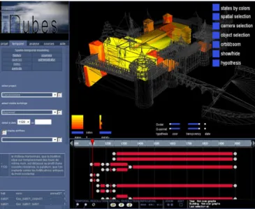
Figure 5. NUBES web interface. The graphs on the bottom describe buildings lifespan and their "temporal position".
The web application is based on an architecture in three parts: firstly a 3D scene developed in Virtools DEV allows the real-time geometry manipulation of different restitutions ; secondly, a SVG interface allows the reading of historical transformations by means of serverside dynamic graphs generated with PHP on MySQL ; finally, a PHP page allows the user the online consultation (selection of project, temporal states, assumptions, and data display).
The generated graphs fulfil different goals. Firstly, they allow the display of transformations and relations among buildings in time; secondly, each graph retains transformation history, included complex transformations such as union, division and reconstruction; thirdly, graphs interact with geometry displaying transformations both on the scene and the 2D interface; finally, they allow to adjust representation according to various spatial and temporal resolutions.
VI. CONCLUSIONS
This paper has investigated a hybrid approach to structure a Digital Mock-Up, to validate it by experts and finally to consult data in a web system. However, important aspects need to be considered in future researches. Firstly, hypothetical and existing restitutions should be defined in a structural continuity. Secondly, graphs can be described in a 3D space where the third dimension stores the each graph history, i.e. components constituting each graph for each historical period.
REFERENCES
[1] P. Salonia, A. Negri, L. Valdarnini, S. Scolastico, et V. Bellucci, “Quick photogrammetric systems applied to documentation of cultural heritage: the example of Aosta roman city wall,” CIPA 2005 – XX International Symposium, Torino, Italy: 2005.
[2] D. Laboury et V. Morceau, “A new tool for 3D archeological and epigraphic recording,” Virtual Retrospect 2005, Biarritz, France: Ausonius éditions, 2005, pp. 60-66.
[3] B. Fischer, “Mission and recent project of the UCLA Cultural Virtual Reality Laboratory,” Virtual Retrospect 2005, Biarritz, France: Ausonius éditions, 2005, pp. 65-74.
[4] A. Serrato-Combe, “From Aztec pictograms to digital media,” Reinventing the Discourse. How Digital Tools Help Bridge and Transform Research, Education and Practice in Architecture, Syracuse: W. Jabi, 2001, pp. 34–43.
[5] R. Theron, A.I. Gonzalez, F.J. Garcia, et P. Santos, “The use of information visualization to support software configuration management,” Computer Science, Ammersee, Germany: 2007, pp. 317-331.
[6] K.M. Kensek, L.S. Dodd, et N. Cipolla, “Fantastic reconstructions or reconstructions of the fantastic? Tracking and presenting ambiguity, alternatives, and documentation in virtual worlds,” Automation in Construction, 2004, pp. 175– 186.
[7] T. Strothotte, M. Masuch, et T. Isenberg, “Visualizing Knowledge about Virtual Reconstructions of Ancient Architecture,” Proceedings of the International Conference on Computer Graphics, IEEE Computer Society, 1999, p. 36.
[8] A.T. Pang, C.M. Wittenbrink, et S.K. Lodh, “Approaches to
Uncertainty Visualization,” The Visual Computer, vol. 13, 1997, pp. 370-390.
[9] N.A. Koshak et M. Gross, “3D Modeling of Historic Makkah: Strategies for Constructing Accurate CAD Models of Historic Buildings,” Osaka, Japan: 1998.
[10] M. Boden, Mind As Machine: A History of Cognitive Science, Clarendon Press, 2006.
[11] C. Weber et P. Gançarski, Revue Internationale de Géomatique. European Journal of GIS and Spatial Analysis, 2007. [12] N. Pelekis, B. Theodoulidis, I. Kopanakis, et Y. Theodoridis,
“Literature review of spatio-temporal database models,” Knowl. Eng. Rev., vol. 19, 2004, pp. 235-274.
[13] J. Thomson, E. Hetzler, A.M. MacEachren, M. Gahegan, et M. Pavel, “A typology for visualizing uncertainty,” Society of Photo-Optical Instrumentation Engineers (SPIE) Conference Series, 2005, pp. 146-157.
[14] M. Leyton, Symmetry, Causality, Mind, The MIT Press, 1992. [15] L. De Luca, “Relevé et multi-représentation du patrimoine architectural
: définition d’une approche de reconstruction 3D d’édifices,” Engineering, ENSA Marseille, 2006.
[16] A. Renolen, “Concepts end methods for modelling temporal and spatio-temporal information,” Norwegian University of Science and Technology, NTNU, 1999.
[17] A. Renolen, Generalization and Data Reduction in Spatiotemporal Data Sets, Trondheim, NORWAY: Department of Surveying and Mapping, 1997.
[18] E.R. Tufte, The visual display of quantitative information, Cheshire, Conn.: 1992.