COMMUNAUTÉ FRANÇAISE DE BELGIQUE
UNIVERSITÉ DE LIÈGE – GEMBLOUX AGRO-BIO TECH
Towards a regional soil reference system for fertility
assessment and monitoring in the highlands
of Mindanao, Philippines
Guadalupe M. DEJARME-CALALANG
Dissertation originale présentée en vue de l’obtention du grade de Docteur en
Sciences Agronomiques et Ingénierie Biologique
Promoteurs: Laurent Bock
Gilles Colinet
ii
To RODOLFO, my husband
and my sons, JANSSEN and JAMES CONRAD,
this work is dedicated.
iii Acknowledgment
I am truly grateful to all, who in one way or another have supported me in this challenging work.
To the Cooperation of Universities for Development (CUD) for the scholarship grant,
To Xavier University, Philippines, for the study leave grant and research support through its Faculty Development Program.
To Prof Laurent Bock, my PhD Promoteur, to whom I deeply acknowledge, for unselfishly imparting to me his knowledge in Soil Science through his utmost guidance in the over-all PhD research, and his incessant encouragement that get me through in this intellectually and physically demanding work,
To Prof Gilles Colinet, Co-Promoteur for assisting me in the data gathering, who painstakingly had checked the pot experiment part of the manuscript, and for his guidance on the statistical analyses,
To the five MSc students who worked with me in this CUD project and shared to me their gathered information, Lola Richelle, Fanny Lebrun, Sophie Barbieux, Sophie Van Daele of Universite de Liege-Gembloux Agro Bio Tech (ULg-GxABT), and Simon Maurissen of Universite Libre de Brussels,
To the members of the PhD Committee; Prof Aurore Degre of ULg-GxABT and Prof Vincent Hallet of Universite de Namur for their assistance in the data gathering, Prof Philippe Lebailly and Prof Guy Mergeai of ULg-GxABT, Prof Joseph Dufey and Prof Sophie Opfergelt of Universite Catholique de Louvain for their valuable comments and suggestions to improve the study and PhD manuscript, and to Dr. Valerie Genot, for the NIRS analysis of the soil samples,
I sincerely am thankful to the two farming communities, Miarayon and Bendum for the friendship and safety during the field work,
I deeply acknowledge the help of Barangay Captain Robert Sulatan and Lanie Sulatan who assisted me in organizing the fieldwork in Miarayon, for without them, it would be difficult for me to infiltrate the area, to Sr Jessica Gemino and the Missionary Sisters of the Sacro Costato, Mateo Sanchez SJ and Miriam Layucan of the St Therese of the Child Jesus Parish, Noel and Nenet Hanginan for accommodating us during the field work, the farmers and their families who collaborated with me in the work, Corsino Buling and family, Roel Buling and family, Dodong and Zelda Flores, Jermie Angel, Virginio Sulod, the late Florito Bagas and his family, Nerio Salino, Ranilo Lajero and family, Hermilito Angel, Jerson Angel, Myrna and Zeke Sanghid, Sergio Hinganan, Roberto Memper, Eugenio Lagayon, Adogar Member, Felix de la Cerna, Mariano and Virginia Sulatan, Lucio Laguilay, the late Enerio Hinganan and his sons, to those who had provided the muscles during the augering and pit digging, Bernardo Sulatan, Jake Memper, Patrino Inta, Jick and Jig Sulatan, Albert Memper, Johnny and Jay Sulatan and Hernan Palma.
To the Bendum Community; the farmers who collaborated with me in the Bendum work, Julie Menaling, Nestor Menaling, Hipolito and Joy Buaya, Myrna Berdisula, Julie Gallamaso, Man Dagnayan, Norberto Navas, Berto Banahan, Dole Deloso, Danny Bono, Genara Hewe, to those who assisted us in pit digging and soil sampling Anecito Santer, Rufino Sagula, Jessie Berdisula, Nilo Almahan, Jason Menaling and to the pupils of Apo Palamguwan Cultural Education Center who always had accompanied us to the field.
iv To the Soil Science Unit Staff of ULg-GxABT, to Raphael Tarantino for all his assistance given, from administrative organizations to computer concerns, Amandine Lienard for constantly checking with me my ECTS requirements, to Beatrice Lagrange and Malorie Renneson for the logistical support and to Francoise Toussant for the plant and soil analyses.
To the Environmental Science for Social Change (ESSC); Andres Ignacio and to the very supportive ESSC staff Arnel Santander, Eric “Popoy” Bruno, Cherie Domer, Freida Tabuena, Leanne Fernandez, Ceasar Aguinaldo, Ariel Amor, Jenifer Ogaña, Eddie Campos, Aili Gatuslao, Joan Jamisolamin and Robelito Buntas.
To Xavier University colleagues: to Dr Lina Kwong, Mark Alexis Sabines and Alexis Maristaza of the Agricultural Engineering Department, to Glenda Orlanes and Reynaldo Antonio Mante of the College of Agriculture-Assistant Dean’s Office, Bern Geveso and Virgie Bulang of the Office of the President for the various assistance, to Lorna Picar and Richel Malon of the Central Purchasing Unit for facilitating the purchase of the Isuzu Fuego and spare parts, to Ramil Pajo and Noemi Dacudao of the Physical Plant Office, for the conversion of a space into a Soil Laboratory, to Jofferdale Gallamaso for the laboratory design, to Franciso Umaran for setting-up the internet connection in the laboratory and its maintenance, and to Madame Elisabeth Enerio of the Office of International Cooperation and Networking, for her assistance in my difficulties of the French language.
To Hernando Pacana and the Manresa Experimental Research Station workforce of Xavier University, Aldwin Palanas, Allan Ranis, Boeding Mingoc, Nestor Diango, Samuel Libot and Arnold Casil for facilitating the work, from the construction of the pot experiment shed, the driving services provided during field work, the maintenance of the soil laboratory and of the field work vehicle, to the Manresa Security Unit for the safety provided during the numerous overnight-stays in the Soil Laboratory because of the PhD manuscript preparation.
I truly appreciate Prof Françoise Orban and her family for they are my family in Belgium. I am grateful for the welcoming and generosity of Madame Jennifer Bock and her family, from the weekend dinners, the transport facilitated from and to Brussels airport, to the provisions of home effects for my apartment, to Madame Françoise Descamp, Monsieur Thierry Henckaerts and Madame Alix Raway for always providing me a place in Maison Nord Sud, my home in Gembloux.
To the Jesuit fathers; Jose Ramon T Villarin SJ and Peter W Walpole SJ, for whom through them I was able to find the PhD grant, and to Roberto C Yap SJ for continuing the support until the end of my PhD study.
Thank you.
v Abstract
This PhD research work is a contribution to the umbrella research project in Mindanao, Philippines entitled “Establishing strategic partnership in research to strengthen local governance in
land and water management for greater human security in Mindanao (EPaM)” which was supported
by the Cooperation of Universities for Development - Inter University Program (CUD-PIC) of Belgium
with the long term objective to capacitate local entities in managing land and water resources in their
jurisdiction.
As part of the CUD-PIC project, the research has two objectives: (1) the establishment of a
Soil Reference System (SRS) to respond to the needs of soil information for scientific bases in land use
planning and agricultural development at the local level, and (2) the use of this established SRS as a
pertinent tool for agricultural extension services to local farmers on soil management and crop
production.
The specific study locations were Miarayon, Talakag and Bendum, Malaybalay City of the
Bukidnon Province.
The study had four sub components: (i) the geomorphopedological identification of
potentialities and constraints, (ii) the soil fertility assessment with predominant crop yields to initiate a
SRS as bases for monitoring in the future, (iii) the soil fertility assessment and calibrating using a test
plant in a pot experiment, and (iv) the information integration of the SRS for highland areas in
Mindanao, Bukidnon.
Miarayon and Bendum soils are both derived from volcanic parent materials, but their
development differs by duration and rock origin. Bendum soils are derived from ultramafic rocks in the
periods of Upper Cretaceous and Paleogene and Oligocene Lower Miocene while Miarayon soils
originated from pyroclastic rocks of the Pliocene-Quaternary period. Dominance of total elements in
soils of both areas is due to either natural causes or anthropogenic activities. The dominance of Mg in
Bendum rocks is effectively due to its ultramafic parent rock materials while in Miarayon the prevalence
of Ca is due to the application of chicken dung in which chicken feed formulas have Ca additives.
vi than Bendum soils. The encroachment of cultivation on the steep slopes in both areas indicates the high
demand of lands for production in the highlands.
Crops in Miarayon which are intended for the market are short term, such as vegetables, with a
growing season of three to four months. Bendum crops that are for the market are perennial ones such
as rubber and coffee and therefore are long term crops, and abaca which are for fiber materials. Food
crop in Miarayon is corn while in Bendum is corn and sweet potato. Crop yields are indicators of soil
fertility and crop management in a given prevailing climate. In Miarayon soils, there is a good
relationship between the yields of potato and TOC, TN, Ca and Mg. There is also a good relationship
between yields of corn and Ca and Mg. The robustness of relationships is shown in spite of few
observations.
A pot experiment was carried out to test the response of a plant to different soil types. Results
on plant nutrient analyses had shown the transfer of elements, from parent rock materials, to soil
formation and until the nutrient absorption by the test plant. Results had corroborated the findings in
literature researches about which nutrients are prevalently assimilated by test plants.
The methodology used in this SRS shall serve as template for instruction and research on soils
in Mindanao. The integrated information is good input for extension work on soil management and crop
production at local level. To achieve a good data density, the Near Infrared Reflectance Spectroscopy
(NIRS) is a promising technology in soil analysis. Findings in this research work had led to the
following recommendations: (i) disseminate the developed SRS methodology and framework and
replicate the work in other highland areas in Mindanao, Philippines, (ii) Disseminate the established
SRS in the region, (iii) study the sustainability of highland agricultural production, (iv) make
follow-up studies on soil nutrient dynamics, (v) study the hydropedology of highland areas, (vi) establish soil
vii Résumé
Cette recherche doctorale a été réalisée dans le cadre du Projet d’Initiative Ciblé (PIC) intitulé « Establishing strategic partnership in research to strengthen local governance in land and water
management for greater human security in Mindanao (EPaM project) » qui a été conduit aux Philippines
grâce à un financement de la Coopération Universitaire belge au Développement (CUD). Ceci avec
l’objectif à long terme d’améliorer les capacités locales dans la gestion des ressources en terres et en eau dans leur juridiction.
Dans ce cadre, notre contribution visait (1) à l’établissement d’un système de référence sur les sols (SRS) pour répondre aux besoins d’information sur les sols comme bases scientifiques en planification dans l’usage des terres et le développement agricole au niveau local, et (2) à l’application d’un tel système dans les conseils personnalisés à l’agriculteur en matière de gestion des sols et de production agricole. Les sites d’études, situés en Province de Bukidnon, sont le village de Miarayon
dans le district de Talakag et celui de Bendum dans le district de Malaybalay City.
Plus spécifiquement, l’étude a comporté quatre volets, à savoir : (i) l’identification géomorphopédologique des potentialités et des contraintes, (ii) l’évaluation de la fertilité des sols en pleins champs eu égard aux rendements des cultures dominantes et ce, pour initier le système de référence sur les sols et un suivi dans l’avenir, (iii) l’évaluation de la fertilité des sols en milieu contrôlé (pots) eu égard à une plante de référence, et (iv) l’intégration de l’information en ce système de référence sur les sols pour les Hautes terres de Mindanao, Bukidnon.
Les sols de Miarayon et de Bendum sont dérivés de matériaux parentaux d’origine volcanique, mais leur développement diffère par l’âge et la nature même des roches. Les sols de Bendum sont dérivés de roches ultramafiques d’entre le Crétacé supérieur et le Miocène inférieur tandis que ceux de
Miarayon sont dérivés de roches du Pliocène et du Quaternaire. La dominance de magnésium dans les
roches de Bendum est précisément due à ce caractère ultramafique. Les sols de Miarayon ont par contre
des teneurs plus élevées en matière organique et advantage d’éléments disponibles que ceux de Bendum.
Les fortes teneurs en éléments totaux dans les sols des deux sites est soit due à des causes naturelles
viii de volaille car les formules alimentaires sont riches en cet élément. La progression des cultures sur les
sols de fortes pentes indiquent que, dans les deux sites, la demande en sols pour la production agricole
est importante dans les Hautes terres.
Les cultures à Miarayon qui sont destinées au marché telles que les légumes sont de court terme
avec une période de croissance de trois à quatre mois. Les cultures de Bendum qui sont destinées au
marché telles que le caoutchouc et le café sont pérennes ; il en est de même de l’abaca qui est cultivé
pour ses fibres. Les cultures vivrières sont le maïs à Miarayon et le maïs et des plantes racines à Bendum.
Les rendements des cultures sont indicateurs de la fertilité des sols et de la gestion de ces cultures dans
un contexte climatique donné. Dans les sols de Miarayon, il y aune bonne corrélation entre les
rendements en pommes de terre et la teneur en carbone organique total, en azote total, en calcium et
magnésium ainsi qu’avec le rapport C/N. Il y a aussi une bonne corrélation entre le rendement en maïs, le calcium et le magnésium. La robustesse des corrélations est montrée malgré le relativement faible
nombre d’observations.
Une expérimentation en pots a été conduite pour tester la réponse d’une plante test à différents
types de sol. Les résultats des analyses de plante ont montré le transfert des éléments, du matériau parental, au sol et jusqu’à l’absorption par la plante test. Ces résultats ont corroboré les données de la littérature quant à la prévalence des nutriments.
La méthodologie utilisée dans ce système d’information sur les sols servira de canevas pour l’éducation et la recherche sur les sols à Mindanao. L’intégration de l’information constitue une bonne base pour la vulgarisation en matière de gestion des sols et de production agricole au niveau local. Pour
obtenir une bonne densité de données, la spectroscopie dans le proche infrarouge constitue une
technologie prometteuse en analyse de sol.
Les résultats de ce travail de recherche conduisent aux recommendations suivantes : (i) disséminer la méthodologie et le canevas du système d’information sur les sols ainsi développé et reproduire le travail dans d’autres sites des Hautes terres à Mindanao, Philippines, (ii) disséminer dans la région le système établi, (iii) étudier la soutenabilité de la production agricole dans les Hautes terres,
ix hydropédologiques des Hautes terres, (vi) établir des programmes de conservation des sols, et (vii)
x CONTENTS Title Page Acknowledgement iii Abstract v Résumé vii Table of content x
List of Tables xvii
List of Figures xx
Chapter I Introduction 1
1. Chapter overview 1
2. Land, a vital resource for Philippine agriculture 2
3. Socio-economic and agroecosystem issues in the Philippine highlands 3
4. The LandIS for land use planning in agricultural development 5
5. The general research questions 8
6. The general objectives 8
7. The research framework 9
8. Organization of dissertation discussions 13
Chapter II The highlands of Bukidnon, Northern Mindanao, Philippines: Location of investigation
14
1. Chapter overview 14
2. Bukidnon, the chief contributor to the Northern Mindanao agricultural economy 15
3. Geography and topography of Bukidnon 16
4. Specific study location descriptions 17
4.1. The Miarayon sub-catchment 17
4.2.The Bendum sub-catchment 20
5. The Bukidnon climate 22
6. Bukidnon’s geological background and associated rocks 24
7. Bukidnon soils in perspective 28
8. Mineralogical studies on Bukidnon soils 31
xi
10. Physical characterization of Bukidnon soils 33
11. Chemical characterization of Bukidnon soils 33
12. Chapter conclusion 35
Chapter III Geomorphopedology, potentialities and constraints identification of the Bukidnon highland soils, Northern Mindanao, Philippines
37
1. Chapter overview 37
2. Significance of the study 39
3. Objectives of the study 40
4. Methodology 41
4.1. The Miarayon fieldwork 41
4.2. The Bendum fieldwork 42
4.3. Soil laboratory work for Miarayon and Bendum soil pit samples 46
5. Results and discussions 47
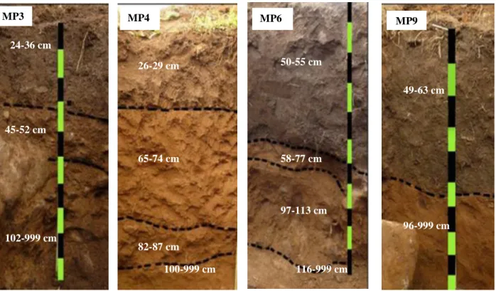
5.1. Miarayon Soil Groups 47
5.2. Bendum Soil Groups 52
5.3. Morphological characterization 54
5.3.1. Morphological characteristics of Miarayon soils 54
5.3.2. Morphological characteristics of Bendum soils 57
5.4. Rocks, minerals and total elements 58
5.4.1. Rocks, minerals and total elements in Miarayon soils 58
5.4.2. Rocks, minerals and total elements in Bendum soils 63
5.5. Soil potentialities 66
5.5.1. Potentialities of Miarayon soils 67
5.5.1.1. Physical potentialities of Miarayon soils 67
5.5.1.2. Chemical potentialities of Miarayon soils 70
5.5.2. Potentialities of Bendum soils 75
5.5.2.1. Physical potentialities of soils in Bendum cultivated areas 75
5.5.2.2. Chemical potentiality of soils in Bendum cultivated areas 75
5.6. Soil constraints 79
5.6.1. Morphological limitations of Miarayon soils 79
xii 5.6.3. Morphological limitations of soils in Bendum cultivation areas 82
5.6.4. Chemical limitations of soils in Bendum cultivation areas 83
6. Chapter conclusion 85
6.1. Soil classification and morphology comparisons between Miarayon and Bendum soils 85
6.2. Soil forming minerals detected in Miarayon and Bendum soils 85
6.3. Physical properties of Miarayon and Bendum soils 86
6.4. Miarayon and Bendum soil potentialities 86
6.5. Miarayon and Bendum soil constraints 87
6.6. The natural and anthropogenic influences in Miarayon and Bendum soil development 87
Chapter IV Topsoil fertility assessment at plot level in association with predominant crop yields in Bukidnon highlands, Northern Mindanao, Philippines
89
1. Chapter overview 89
2. Significance of the study 90
3. Objectives of the study 91
4. Study site description 91
4.1. Miarayon crop production location 92
4.1.1. Miarayon crop plot areas 93
4.1.2. Miarayon crop plot sizes 93
4.1.3. Crop plot production management practices in Miarayon 94
4.1.3.1. Potato 94
4.1.3.2. Carrot 95
4.1.3.3. Corn 96
4.2. Bendum production areas 96
4.2.1. Crop production management practices in Bendum 96
4.2.2. Bendum crop plot sizes 98
5. Methodology 99
5.1. Miarayon topsoil sampling 99
5.2. Bendum topsoil sampling 99
5.3. Laboratory work for Miarayon and Bendum soils 100
5.4. Crop yield measurement procedures 101
xiii
6. Results and discussions 103
6.1. Miarayon soil fertility assessment results 104
6.1.1. Morphological characterization of pedons in the specific study areas in Miarayon
104
6.1.2. The general view of topsoil fertility in Miarayon 104
6.1.3. Soil fertility comparisons between Salsalan and Mambuaw, Miarayon 106
6.1.3.1. Soil pH 107
6.1.3.2. TOC, TN and C:N ratio 107
6.1.3.3. Available P 108
6.1.3.4. Available Ca 109
6.1.3.5. Available Mg 110
6.1.3.6. Available K 111
6.1.4. Nutrient associations with each other in Miarayon soils 112
6.1.4.1. On soil pH, TN, TOC and Ca relationships 112
6.1.4.2. On soil pH and exchangeable bases relationships 113
6.1.5. Soil fertility level comparisons between Salsalan and Mambuaw, Miarayon 113
6.1.5.1. TOC, TN and K 114
6.1.5.2. Soil pH available Ca, Mg, Na and exchangeable acidity and Al 114
6.2. Soil fertility assessment results for Bendum topsoils 115
6.2.1. Morphological characterization of pedons in Bendum specific areas of study 115
6.2.2. The overview of soil fertility status in Bendum 115
6.2.2.1. Soil pH of Bendum cultivated areas 117
6.2.2.2. TOC and TN in soils of Bendum cultivation areas 117
6.2.2.3. Available Ca, Mg, K and Na in soils of Bendum cultivation areas 118
6.2.3. Nutrient associations with each other in Bendum topsoils 118
6.2.3.1. Relationships of soil pH with TOC, TN and C:N ratio 119
6.2.4. Soils in abaca, coffee and rubber plots of Bendum cultivation areas 120
6.2.5. Soil fertility differences between two cultivation areas in Bendum 120
6.3. Miarayon crop yield measurements and soil fertility assessments 121
6.3.1. Yields of carrot, corn and potato in Miarayon 121
6.3.2. Crop yield calibration with soil fertility levels in Miarayon 123
6.3.2.1. Relationships between carrot yield and topsoil nutrients 123
xiv 6.3.2.3. Relationships between corn yield and topsoil nutrients 126
6.4. Bendum crop yield measurement results 127
6.4.1. Crop yields and topsoil fertility in Bendum production areas 127
7. Chapter conclusion 129
7.1. Topsoil fertility comparison and soil management practices in crop production 130
7.2. Crop yields of Miarayon and Bendum 131
7.3. General appreciation 132
Chapter V Soil fertility assessment and monitoring through pot experiment for Bukidnon agricultural highland soils, Northern Mindanao, Philippines
133
1. Chapter overview 133
2. Significance of the study 134
3. Objectives of the study 134
4. Methodology 135
4.1. Soil media gathering and preparation 135
4.2. The experiment 135
4.2.1. The test plant 137
4.2.2. Conduct of the pot experiment 137
4.2.3. Soil analyses 138
4.2.4. Plant analyses 138
4.2.5. Statistical analysis methods 140
5. Miarayon results and discussions for soil and test plant relationships 140
5.1. Biomass fresh weights of harvested Signal grass in the Miarayon study 140
5.2. Biomass fresh weights in relation to the properties of Miarayon topsoils 141
6. Bendum results and discussions 144
6.1. Biomass fresh weights of harvested Signal grass and their relationships with Bendum topsoils
145
7. Analyses of nutrients assimilated by the test plant in Miarayon and Bendum soils 146
7.1. Relationships between nutrients assimilated by the test plant 147
7.2. Correlations of plant assimilated nutrients by Principal Component Analysis (PCA) 152
7.3. Differences between plant element contents which were assimilated from Miarayon and Bendum soils
152
xv
8.1.The test plant biomass and the soil nutrients 155
8.2. Assimilated nutrients from Miarayon and Bendum soils 156
8.3 The relationships between assimilated nutrients in test plant from Miarayon and Bendum 157
8.4. The effects of site and soil factors on nutrient assimilation rates 157
Chapter VI The SRS for Bukidnon highlands, Northern Mindanao, Philippines: Soil information integration and the prospects of soil analysis in the region
158
1. Chapter overview 158
2. Significance of integrated soil information 159
3. Objectives of information integration 160
4. Methodology 160 4.1. Geological aspects 161 4.2. Geomorphological aspects 161 4.3. Pedological aspects 161 4.4. Edaphological aspects 162 4.5. Socio-economic aspects 163
5. Results and discussions 163
5.1. Miarayon and Bendum soils 163
5.1.1. Miarayon soil features 163
5.1.2. Bendum soil features 169
5.1.3. Soil potentialities of the two sub-catchments 172
5.1.4. Soil constraints of the two sub-catchments 172
5.2. Application of NIRS to the soils of Miarayon and Bendum 174
6. Chapter conclusion 176
Chapter VII Conclusions and recommendations 178
1. Chapter overview 178
2. Conclusion discussions 179
2.1. Geomorphopedology, potentialities and constraints identification 179
2.2. Soil fertility assessment by topsoil nutrient analyses and crop yield measurements 180
2.3. Soil fertility assessment by plant response through pot experiment 181
2.4. Integration of all information to a Soil Reference System for agricultural land use planning
xvi
3. Recommendations 182
3.1. Disseminate the developed Soil Reference System framework and methodology and replicate the work in other highland areas in Mindanao, Philippines
182
3.2. Disseminate the established Soil Reference System in the region 183
3.3. Study the sustainability of highland agricultural production 183
3.4. Make follow-up studies on nutrient dynamics 184
3.5. Study the hydropedology of highland areas 185
3.6. Establish soil conservation programs for agricultural highland areas 186
3.7. Conduct environmental toxicology studies in highland vegetable areas 186
xvii LIST OF TABLES
Table No. Title Page
Table II-1 Area planted and yield of major crops in Bukidnon and Northern Mindanao (2012).
16
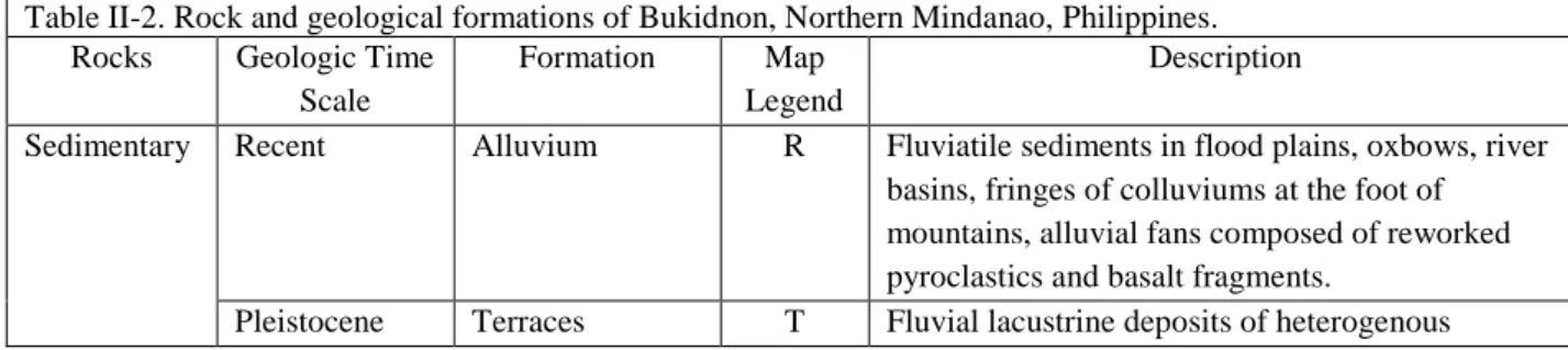
Table II-2 Rocks and geological formation of Bukidnon, Northern Mindanao, Philippines. 24
Table II-3 Soils in Bukidnon, Northern Mindanao, Philippines. 29
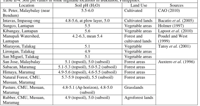
Table II-4 Soil pH values in some highland locations in Bukidnon, Philippines. 34
Table III-1 Soil classification, qualifiers, position, elevation and slope of studied pedons in Miarayon, Bukidnon.
50
Table III-2 P retention and sesquioxides in two horizons of selected pedons in Miarayon. 51
Table III-3 Soil groups, position, elevation, slope and land cover of studied pedons in the cultivated areas of Bendum, Bukidnon.
54
Table III-4 Summary of morphological properties of Miarayon soils. 56
Table III-5 Summary of morphological properties of soils in Bendum cultivation areas. 57
Table III-6 Analysis results of a representative rock samples from Pedon MP2 location of Miarayon (%).
59
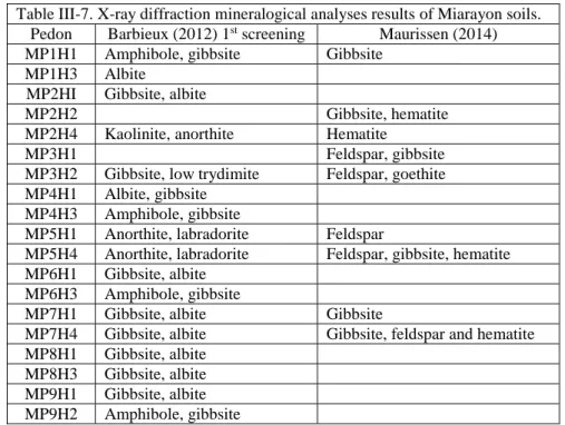
Table III-7 X-ray diffraction mineralogical analyses results of Miarayon soils 60
Table III-8 Total element contents of Miarayon soils 61
Table III-9 Analysis results of representative rock samples from Bendum cultivation areas (%).
64
Table III-10 X-ray diffraction mineralogical analyses results for Bendum soils 65
Table III-11 Total element contents of pedon samples from Bendum cultivation areas 66
Table III-12 Physical properties of Miarayon soils 68
Table III-13 Potential total element reserves in one hectare at a depth of the pedon’s first 20 cm in Miarayon soils
74
Table III-14 Physical properties of Bendum topsoils 76
Table III-15 Potential total element reserves in one hectare at a depth of the pedon’s first 20 cm of soils in Bendum cultivation areas.
79
Table III-16 Guidelines in interpreting soil pH values (1:2.5 soil-water ratio). 81
Table III-17 The ratio between exchangeable Al and ECEC of top horizons pedon samples of Miarayon.
82
Table III-18 P concentration values, total Al and total Fe of soils in Bendum cultivation areas. 84
Table IV-1 Sizes of production and fallow plots in Miarayon. 93
Table IV-2 Plot sizes of predominant crops in Bendum cultivation areas. 98
Table IV-3 Soil classifications and characteristics of the two study sites for field yield measurements.
xviii
Table IV-4 Summary of soil analysis results for Miarayon composite topsoil samples. 105
Table IV-5 Topsoil composite sample analysis results in yield measured carrot, potato and corn plots.
106
Table IV-6 Phosphorous in Miarayon pit soil samples 109
Table IV-7 Effective Ca saturation ratios of the top horizons of pedons in areas where composite samples were taken and crop yields were measured.
110
Table IV-8 Correlations of pH H2O, TOC, TN, C:N ratio, Ca, Mg, K and Na in Miarayon soils.
112
Table IV-9 Soil fertility level differences between Salsalan and Mambuaw, Miarayon 113
Table IV-10 Summary of soil analysis results for topsoils in Bendum cultivation areas. 116
Table IV-11 Correlations of pH H2O, TOC,TN, C:N ratio, Ca, Mg, K and Na in Bendum soils of cultivation areas.
119
Table IV-12 Differences between soil fertility levels of BP9 and BP14 121
Table IV-13 Crop yields and plant densities of carrot, corn and potato in Miarayon. 122
Table IV-14 Correlations between crop yields and soil fertility levels of Miarayon soils. 123
Table IV-15 Yield measurement results of corn, ginger and sweet potato plots in Bendum cultivation areas.
127
Table IV-16 Plots with crop yields and their respective soil nutrient levels in Miarayon. 129
Table V-1 Soil chemical properties of the first horizons of the soil pedons in Miarayon 139
Table V-2 Soil chemical properties of the first horizons of the soils in Bendum production areas
139
Table V-3 Biomass yields of Signal grass planted on Miarayon soils (g). 140
Table V-4 Biomass fresh weights and soil properties correlations of Miarayon soils 141
Table V-5 Total elements assimilated by the Signal grass and total element contents of soils in pots from Miarayon.
143
Table V-6 Fresh biomass yields of Signal grass planted on topsoils of Bendum production areas (g).
145
Table V-7 Signal grass biomass fresh weights and total element contents of Bendum topsoils.
145
Table V-8 Total elements assimilated by the Signal grass and total element contents of soils in pots from Bendum.
146
Table V-9 Correlations between absorbed total elements by Signal grass in Miarayon and Bendum soils
147
Table V-10 Analysis of variance of element contents in the test plant from Miarayon and Bendum
153
Table VI-1 Soil information integration for Miarayon sub-catchment, Talakag, Bukidnon, Philippines.
xix Table VI-2 Soil information integration for Bendum sub-catchment, Malaybalay, Bukidnon,
Philippines.
170
Table VI-3 Potentialities and constraints of Miarayon and Bendum soils. 173
Table VI-4 Correlations between actual and predicted values of some parameters for Miarayon and Bendum soils.
xx LIST OF FIGURES
Figure No. Title Page
Figure I-1 Highland cultivation areas in the Philippines 4
Figure I-2 The land use planning process (FAO, 1989) 7
Figure I-3 The research conceptual framework 11
Figure I-4 The initial field investigation framework 12
Figure II-1 Map of Mindanao and Northern Mindanao with Philippines inset 14
Figure II-2 Cagayan de Oro River watershed map showing the Miarayon sub-catchment within the Batang catchment.
18
Figure II-3 Geomorphological map of Miarayon sub-catchment 18
Figure II-4 Miarayon position relative to Mt. Kalatungan, Talakag, Bukidnon 19
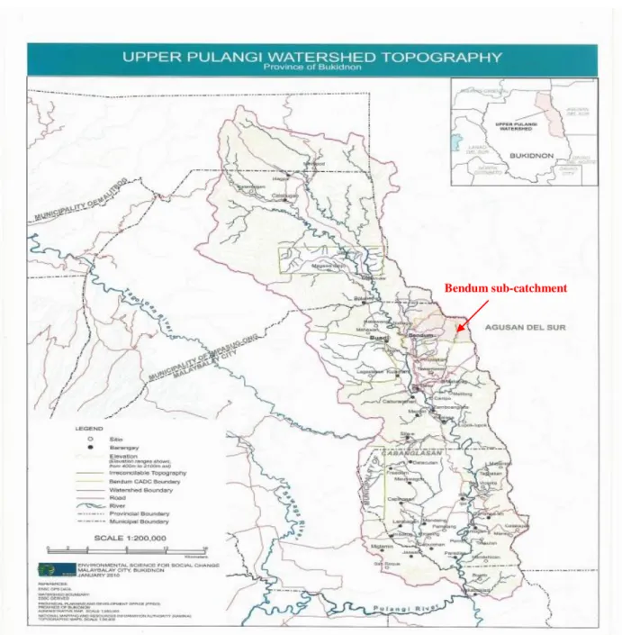
Figure II-5 Upper Pulangui watershed and the Bendum sub-catchment 20
Figure II-6 Geomorphological sketch of Bendum sub-catchment 21
Figure II-7 Bendum is generally a forest area with patches of cultivated plots 21
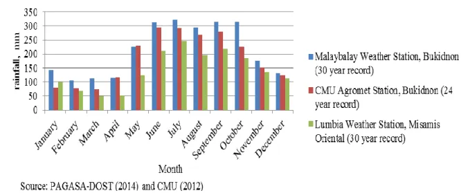
Figure II-8 Mean monthly rainfall record from meteorological stations in Bukidnon and Misamis Oriental, Mindanao, Philippines
22
Figure II-9 Average monthly air temperature records of two meteorological stations in Bukidnon
23
Figure II-10 Stratigraphic units of Bukidnon geology 27
Figure II-11 Portion of geological maps of Miarayon and Bendum 28
Figure II-12 Portions of Bukidnon Soil Map showing Miarayon, Talakag and Bendum Malaybalay
30
Figure III-1 Diagrammatic representation of the hypothetical nine unit land surface model. 38
Figure III-2 The path of Miarayon augering series 42
Figure III-3 The Miarayon toposequence 43
Figure III-4 The Bendum toposequences 45
Figure III-5 Cambisols in Miarayon are found on flat and convex positions. 48
Figure III-6 MP2 is Para acric Cambisol. 49
Figure III-7 Umbrisols in Miarayon 50
Figure III-8 Soil pedons of Bendum production areas 53
Figure III-9 TOC and CEC of Miarayon soils 71
Figure III-10 Total Ca in Miarayon soils 72
Figure III-11 Sum of exchangeable bases in Miarayon soils. 72
xxi
Figure III-13 Physical constraints of Miarayon soils. 80
Figure III-14 CEC and TOC of pedon topsoils in Miarayon. 82
Figure III-15 Physical constraints of Bendum soils. 83
Figure IV-1 Miarayon field yield measurement locations. 92
Figure IV-2 Locations of Bendum soil sampling and yield measurement plots. 96
Figure IV-3 Unmaintained plots or due to lack of labor. 97
Figure IV-4 Crop diversification in Bendum. 98
Figure IV-5 Field yield measurements in Miarayon. 101
Figure IV-6 Bendum field yield measurements. 103
Figure IV-7 Correlation graphs between potato yield and soil pH, TOC, TN and available Ca and K in Miarayon.
125
Figure IV-8 Correlation graphs between corn yield and available Ca and Mg in Miarayon topsoils
126
Figure IV-9 Ginger yield of Plot BP9G1 128
Figure V-1 Soil media for pot experiment 135
Figure V-2 Pot experiment procedures 136
Figure V-3 Correlation graphs of biomass fresh weight and exchangeable Ca, exchangeable Mg, total Mn and total Zn in Miarayon soils
142
Figure V-4 Correlations between assimilated total Ca with Mg, K, Na and Fe and total Mg with Na and K of Miarayon and Bendum pot experiments
148
Figure V-5 Correlations between assimilated total Mg with total P, Fe, and Cu and total K with total Na, P and Cu of Miarayon and Bendum pot experiments
149
Figure V-6 Correlations between assimilated total Na with total P and Fe and total P with total Fe, Mn, Cu and Zn of Miarayon and Bendum pot experiments
150
Figure V-7 Correlations between assimilated total Al with total Fe and Cu and total Zn with Mn of Miarayon and Bendum pot experiments
151
Figure V-8 The PCA graphs for the element contents in test plant from Miarayon and Bendum pot experiments
152
Figure V-9 Variations of test plant assimilated nutrients from Miarayon and Bendum soils: (a) Ca (b) Mg, (c) K, (d) Na and (e) P
154
Figure V-10 Variations of test plant assimilated nutrients from Miarayon and Bendum soils: (a) Fe, (b) Al, (c) Mn, (d) Cu and (e) Zn
156
Figure VI-1 Correlations between the actual and predicted values of soil nutrients on samples tested by NIRS: (a) TOC, (b) TN, (c) CEC, and (d) available Mg
175
Figure VI-2 Correlations between the actual and predicted values of soil nutrients on samples tested by NIRS: (a) available Ca, (b) exchangeable Al, (c) exchangeable acidity, and (d) total Fe
1 Chapter I
Introduction
1. Chapter overview
Land, as agriculture’s key resource, is at humankind’s disposal. Its inherent capability to support crop production is less understood and therefore its carrying capacity is less valued. The
desire for economic affluence has led people to overexploit this finite resource and the repercussions
of its unsustainable use have bounced back to the societies' economy and environment. Soil is the
heart of the land and if this heritage is destroyed, it is difficult to restore. Soil degradation and
declining land productivity are among the realities that undermine the food security of a nation’s
vulnerable sector. Choices in using the land have to be carefully planned according to its inherent
capabilities to support a particular development. Planning and management should be substantiated
with scientifically based information to come up with objective decisions in using the land resource.
The Food and Agriculture of the United Nations has named the year 2015 as the International
Year of Soils (FAO-UN, 2015) to acknowledge the importance of this non-renewable and natural
resource which is the basis for healthy food production, the foundation of vegetation, and the earth’s
biodiversity support. This further recognizes the role of soils in humans’ combating and adapting to climate change, strengthening the society’s resilience to natural calamities and for the food security and a sustainable future. The goal of the celebration is to heighten the consciousness of society on the
importance of sustainable soil management as the foundation of food, fuel and fiber production,
environmental balance and to better adjust to the earth’s changing climate. This occasion highlights
the urgency for stakeholders to synergize their efforts to support in protecting this indispensable but
vulnerable natural resource. This PhD research project, even how small this is compared to the global
initiatives in sustainable soil use and management, is a contribution from Mindanao, Philippines
towards the aim of the International Year of Soils 2015. For great things start from small beginnings,
2 The Cooperation of Universities for Development–Inter University Program (CUD–PIC) of
Belgium had granted support to a project in the Philippines entitled: “Establishing strategic
partnership in research to strengthen local governance in land and water management for greater human security in Mindanao (EPaM)”. The partnership was composed of three Universities in
Wallonia, Belgium; the Universite de Liege - Gembloux Agro Bio-Tech (ULg-GxABT), Universite
de Namur (UN) and Universite Catholique de Louvain (UCL) and an institute and two Universities in
Mindanao, Philippines namely: Environmental Science for Social Change (ESSC), Xavier University
(XU) and Ateneo de Davao University (ADDU). The EPaM project had two PhD research subject
areas. The first research subject was the “Development of a generic protocol for an integrated soils
and water Land Information System (LandIS) applied to land use planning in Mindanao, Philippines”.
The second was the “In-depth analysis of factors mitigating the effects of disaster events:
vulnerability to flood and migration in Mindanao. The first subject was the premise of this PhD work
which had sought to build a regional Soil Reference System (SRS) for fertility assessment and
monitoring to provide scientific bases for decisions in agricultural land use planning of highland areas
in Mindanao, Philippines.
This introductory chapter presents the importance of land and soils in Philippine agriculture,
the opportunities they offer and the constraints they are facing and imparts the significance of the PhD
research work. This chapter further presents the questions that this PhD research wishes to answer.
Brief descriptions of each part of this dissertation are discussed in the last section of this chapter.
2. Land, a vital resource for Philippine agriculture
The Philippines with a population of 98.39M, has a total land area of 30M ha in which
agriculture presently occupies 40.58% (World Bank Group, 2014). The Philippine economy is deeply
rooted in agriculture. In the history of the nation's agriculture, the Filipino farmers had raised food
crops for self-sufficiency and for export to the international markets. The country’s agricultural
enterprise had gained prominence in the outside world during the Spanish regime because of its
3 and spices for export (Merino, 1952). Like other tropical countries in the world, the Philippine
agricultural lands are economically, socially and environmentally pressured. Marginal areas and the
highlands are the frontiers of Philippine agriculture and these are encroached for food production
expansion.
In the last century, the demand for land to be devoted for food production had increased to
cope up with the Philippines’ growing population. The country’s population density in 1910 was sporadically spread (28 person-km-2) to a densely inhabited (273 person-km-2) in 2003 (Kastner and
Nonhebel, 2010). In a ten-year period, that is from 2000 (205 person-km-2) to 2010 (308 person-km-2)
this had increased by 20.7% (NSO, 2012). Because of improvements in agricultural technology, the
average capita food supply had been improved in the last century and the amount of land required to
feed a person declined (Kastner and Nonhebel, 2010). In the last 50 years, the size of arable lands had
increased by 10.18% only but the nominal allocation in hectare per person had decreased from 0.18
person-ha-1 in 1961 to 0.06 person-ha-1in 2011 (World Bank Group, 2014). However, the land size
requirement reduction is overtaken by the increase in population which make the overall land
requirement for food much higher than before.
Many of the Philippine soils are derived from volcanic parent materials. Volcanic ash-derived
soils are known to be the most productive and can support intensive agriculture (Poudel and West,
1999; Raymundo and Vicente, 1985). To conserve this natural but vulnerable inheritance, the LandIS
should be developed to come up with an SRS and the obtained facts should effectively be
disseminated to the stakeholders. To aid in coming up with operational decisions for the sustainable
use of agricultural soil resources, information on the SRS shall encompass the present status of its soil
morphology, potentiality and constraints, fertility and productivity.
3. Socio-economic and agroecosystem issues in the Philippine highlands
Poverty in the Philippine rural areas is a phenomenon which remains to be a challenge for
countryside development. The poorest are in the agriculture and fishing sectors (Asian Development
4 regions are supposed to be the frontiers of Philippine agriculture. However, because of the escalating
demand for food production areas, these marginal lands are impinged. The inequity in land ownership
had driven the landless farmers to go up to the highlands and open the forest and cultivate the soil for
the family's subsistence. Farmers too work as paid laborers in agricultural plantations to support their
families.
In Bukidnon, the Philippine government’s move to fast track the development in agriculture and timber industry had paved the way for migrants to settle and cultivate the soil (Lao, 1992) thereby
creating changes in the socio-economic and cultural climate in the Province. The indigenous
population who were unable to adapt and integrate themselves in the new socio-economic mainstream
was pushed up farther to the highlands where they do swidden farming. This was during the postwar
period until the 1970s, when heavy in-migration in Bukidnon had occurred and the new settlers
typically homesteaders had cleared rain forests (Bouis and Haddad, 1990). Swidden (Figure I-1a) is a
term of Scandinavian origin which means “land cleared by burning” and for centuries has been one of the most important land use systems in the tropics, including Southeast Asia (Mertz et al., 2009). This
land use system is practiced in many parts of the Philippines but there are no reliable estimates of its
areal extent (Schmidt-Vogt et al., 2009). Swidden areas are later on converted into permanent crop
fields (Figure I-1b) and because of population expansion in the highlands and for economic reasons
Figure I-1. Highland cultivation areas in the Philippines: (a) a newly opened plot in the Upper Pulangui River catchment and (b) permanent intensively cultivated plot in Upper Cagayan de Oro River catchment (Photos: G. Calalang).
a .
b .
5 these are cultivated intensively.
In recent decades the country’s stabilization of the lowlands intensification has begun and
industrialization has failed to absorb excess labor which resulted to the major migration of subsistence
farmers to the highlands (Cramb, 2005). The exodus of migrants to the highlands that created
population pressure and with pervasive poverty, has led to the deforestation of areas including sloping
lands for crop production (Asio et al., 2009). Cultivation techniques employed in farming are not
appropriate for sloping lands. Lantican et al. (2003) had mentioned that in the Manupali watershed of
Bukidnon highlands, crop production in sloping lands has resulted to high soil erosion rates and
degradation of soil resources not only in the upstream location but also in the downstream. In the
upper slopes of Manupali watershed, soil erosion on commercial vegetable farms was reported to be
largely responsible for crop productivity decline (Poudel et al., 2000).
4. The LandIS for land use planning in agricultural development
Highland areas in the Philippines which are supposed to be the frontiers of the country’s agriculture are under pressure because of current socio-economic, political and environmental situations. The inequitable land distribution, the rising demand of land to grow food and industries’ raw materials, and the declining soil productivity are among the socio-economic factors that cause the
intensive use of highland areas. Land utilization competitions are on agricultural, industrial,
infrastructure development and tourism as well. The decisions in using the resource lie in the hands
of authorized entities. Because the nature of land is less understood, environmental impacts when its
use is changed are unforeseen. Such consequences can include soil compaction, water logging,
increased runoff, soil erosion, pollution and other untoward outcomes of poorly informed decisions in
changing the use of the land.
Concepcion (2000) pointed out that the absence of a national land use policy is among the
issues of concern for sustainable agriculture in the Philippines which had resulted to indiscriminate
conversion of agricultural lands and inadequate monitoring of land conversions, outdated land use
6 security demands of the populace, adequate and quality land and soil resources information are
crucial. The Presidential Decree (PD) 1586, the Philippine Environmental Impact Statement System,
classifies a primary agricultural land as Environmentally Critical Area (ECA) (DENR, 2003). Any
development project in ECAs requires Initial Environmental Examination (IEE) to identify its
potential impacts and justify the purpose of this undertaking. An Environmental Impact Assessment
(EIA) follows if the proposed project has predicted untoward influence to the environment. Impacts
brought about by a development on soils can be best evaluated when quality and comprehensive soil
information are available.
Classical land evaluation approach is based on qualitative models that requires only basic
structural knowledge of the specific landscape and object of evaluation thus should be rearranged
when the land use is changed (Manna et al., 2009). Existing information needs to be in pace with the
demands of the planning exercise and therefore should easily be available and understandable.
Furthermore, land evaluation has to focus not only for food production options but also for ecological,
environmental and social concerns that are progressively more important in the planning process
(Rossiter, 2008).
FAO (1989) had outlined the ten (10) steps of the land use planning which are shown in
Figure I-2. The LandIS which is the pooling of information and a prerequisite when planning for land
resource surveys that leads to the physical evaluation of land for its suitability. An indispensable tool
to scientifically guide decision makers in using the land, the LandIS is imperative in choosing the kind
of agricultural development especially on marginal highland areas in the Philippines where there is no
7 LAND GOALS PLAN STRUCTURE SELECT EVALUATE APPRAISE CHOOSE FORMULATE IMPLEMENT REVIEW USE AND TO THE PROBLEMS PROMISING LAND ALTERNATIVES THE PLAN PLAN AND PLANNING GROUND PLAN AND LAND SUITABILITY BEST REVISE RULES OPPORTUNITIES USES
Step 1 Land use policy Institutional constraints Local experience Step 2 Organize work Step 3 Consider legal constraints Rapid rural appraisal Step 4 Study of relevant land use requirement Step 5 LandIS Land resource surveys Physical land evaluation Step 6 Environmental and socio economic analysis Step 7 Public and executive discussion Step 8 Planning procedure Step 9 Planning for change Coordinate sectoral activities Step 10 Field reports Local experience I N P U T O U T P U T Terms of reference Plan of work Statement of solutions Specifications of land use types Land suitability maps Viable land use options Land use proposals Land use plan Action by land users Revised land use plan
8 As the SRS is the central component of the LandIS, the reference system contains basic
information on the geomorphological characterization, agropedological evaluation, land use information and farmers’ crop management practices. Quality information can be achieved if appropriate methodologies are used in data gathering and therefore, researchers need to take those
approaches that are fitting to the locality.
5. The general research questions
It is founded that natural and anthropogenic factors influence soil development. However,
their effects may differ in locations and situations because of the variations of climate, time of soil
formation, soil parent materials, geomorphology, land use and soil management practices. This PhD
research had sought to answer the following general questions:
i. What are the soil characteristics and the fertility statuses of highland soils in
Mindanao, Philippines?
ii. What are the contributions of the physical environment and anthropogenic activities
in soil properties and characteristics?
iii. Do the agricultural practices influence the soil fertility statuses of highland soils?
iv. Do soils vary in terms of capacity in offering essential nutrients to plants?
v. What are the propositions that can be made in order to reconcile the
agro-environmental issues in the highlands?
The PhD research is an umbrella project that included geomorphopedological characterization, farmers’ land use and management and agropedological evaluation. Particular questions for each study component are highlighted in the specific chapters of this manuscript.
6. The general objectives
The PhD research is a contribution to the sustainable use and management of highland soils.
This primarily had sought to answer the aforementioned general questions by gathering information
9 development that highlighted the steps 5 and 6 of Figure 1-2. The study had aimed to establish a
regional SRS for the highland agricultural areas in Mindanao, Philippines, in order to respond to the
needs of information. To reach the objectives, the PhD work had included a detailed geomorphopedological characterization, farmers’ land use and management determination and agropedological evaluation. The benefits that can be gained in the established regional SRS are
two-pronged. First is that the derived information will serve as support in coming up with scientifically
based decisions in using the land. Second is that the established information can be used in
agricultural extension services to farmers in managing their soils at the local level.
7. The research framework
Figure I-3 presents the research conceptual framework. This shows how an SRS shall
contribute to the building of a LandIS and conversely to agricultural development planning in a
region. In establishing the SRS, the research had considered three key information themes namely; the
geomorphopedological characterization, farmer’s land use and management and agropedological evaluation.
Geomorphopedological characterization deals with the investigations of rocks and minerals,
relief and soil morphology which shall come up with soil classifications, soil potentialities and soil
constraints. Soil physical parameters that were included in the geomorpedophological studies were
soil texture, aggregate structure, bulk density, hydraulic conductivity and water retention capacity.
The determined soil chemical parameters were soil pH, exchangeable acidity and aluminum (Al), total
organic carbon (TOC), cation exchange capacity (CEC), exchangeable calcium (Ca), magnesium
(Mg), potassium (K) and sodium (Na), and total element contents for Phosphorus (P), Ca, Mg, K, Na,
Al, iron (Fe), manganese (Mn), zinc (Zn) and copper (Cu). Additional soil chemical parameters had
included free and amorphous Fe and Al for the soil classifications. Mineralogical analysis was also
conducted in representative soil horizons. Soil classification helps to compare and take the benefit of
10 Soil potentialities are the chemico-physical attributes of soils that are essential in crop
production. Soil constraints are the physico-chemical limitations of soils that deter crop production. Farmers’ land use and management information consists of soil fertility interventions, such as applications of agricultural inputs, cultivation practices and crops grown. Agropedological evaluation
is the assessment of fertility levels in soils. Soil nutrient parameters determined were TOC, total
nitrogen (N), available Ca, Mg, K and Na, available P and pH and were matched with the crops
through field yield observations. To evaluate the soil fertility in a controlled environment, a pot
experiment was conducted to determine the response of a test plant to different types of soils with
their inherent nutrient levels. Parameters for test plant analysis were total Ca, Mg, K, Na, P, Al, Fe,
11
LAND USE PLANNING FOR AGRICULTURAL DEVELOPMENT LandIS Agropedological Evaluation Geomorphopedological Characterization Regional SRS for Fertility Assessment and Monitoring
Topsoil nutrient availability
Crop Yield Evaluation Plant Response to Soil
Conditions
Crop Plot Management Strategies and Practices Cultivation Information:
Crops Planted
Rock
Relief
Farmers’ Land Use and Management Soil Morphology Soil Potentiality Soil Classification Soil Constraints
Figure I-3. The research conceptual framework
Soil chemico-physical characteristics and properties
Field yield – nutrient relationships Biomass yield from
pot experiment
Nutrient assimilation
Food crops Industrial crops
Tillage Maintenance
Other factors
12 The approach that adopted the framework and methodology of Bock (1994) which is the
integration of geomorphopedological and eco/agropedological information had identified the
relationships between soil, rock, relief, land cover and farmers’ soil management practices (Figure
I-4). The geomorphopedological approach offers a methodology to analyze the respective parts of
different factors in soil formation and to understand the spatial distribution as a preliminary step to
soil sampling, analysis and mapping of results. The integration of geomorphopedological and
agropedological approaches was the jump start of the study and was the bases of site selections and
the succeeding study components of the soil umbrella research work which were the identification of
pedon locations, crop yield measurement locations and gathering of soil media for pot experiment.
Data from rocks, relief, and soil morphology and the soil management of the study location were the
basic evidences that were examined in order to draw the picture of how soil properties are functioning
and interrelated with each other. Information gathered encompasses the soil characterization and the
naming of soil classifications.
13 Farmers’ land use and management appraisal data has consisted of cultivation information and the cropping management strategies and practices. Cultivation data were on types of crop and
their growth requirements. Cropping maintenance information were on the planting systems, cultural
maintenance and harvesting. Agropedological evaluation had taken into account the fertility status of
the soil. This was made through topsoil sample chemical analyses. Evaluation was made in two ways.
The first was by cross referencing the topsoil basic nutrient levels with existing predominant crop
yields. This was done by looking into the relationships between crop yields and different nutrient
levels in topsoils. This had tried to find out the possibility of calibrating crop yields with soil fertility.
The second was by the test plant responses to the different soil types and soil nutrient levels through
pot experiment.
8. Organization of dissertation discussions
The discussion organization of this manuscript is as follows: Chapter I, preludes this paper.
Chapter II depicts the research study locations. Chapter III presents the geomorphopedology, soil
potentialities and constraints of the studied highland locations. Chapter IV states the soil fertility, the
yields of existing crops and the farming management and practices in the studied locations. Chapter V
communicates the soil fertility assessment and describes its relationships with the plant responses
using pot experiment. Chapter VI is the integration of all information into a SRS and the justifications
on how this information can contribute to the building of the LandIS as valuable tool for agricultural
land use planning. A very brief section in Chapter VI deals with the prospect of Near Infrared
Reflectance Spectroscopy (NIRS) on soil analysis for the future. Chapter VII covers the conclusions
and recommendations that are formulated from the PhD research which are needed to be done in
14 Chapter II
The highlands of Bukidnon, Northern Mindanao, Philippines: Location of investigation
1. Chapter overview
The Philippine archipelago has a total of 7,100 islands which are grouped into three primary
island clusters: (1) the Luzon group of islands in the northern part and Luzon is the largest island, (2)
the Visayas group in the central part, and (3) the Mindanao group in the southern part of the country
with Mindanao as the cluster’s largest island. Mindanao is the second largest island in the country and has six (6) regional divisions (Figure II-1). The island has a total land area of 10.2 M ha with
4.1 M of alienable and disposable lands and 6.1 M ha of forestlands (MDA, 2012). Northern
Mindanao is composed of five (5) political subdivisions, the provinces which are: Bukidnon,
Camiguin Island, Lanao del Norte, Misamis Occidental and Misamis Oriental.
There are two reasons why Bukidnon Province is the chosen part of Northern Mindanao
highlands as the PhD study location. First, Bukidnon is the largest contributor to the agricultural
economy and food security of the Northern Mindanao region. However, poverty remains to be high.
Figure II-1. Map of Mindanao and Northern Mindanao with Philippines inset (Courtesy of Mark Alexis O Sabines, XUCA Geomatics, Philippines)
15 Second, the Province has few pedological studies and has undifferentiated soils that are in the
mountainous areas (Mariano et al., 1950) which are now under intensive cultivation but are still
unmapped. The research project was conducted in the upper sub-catchments in the watersheds of two
important rivers in Northern Mindanao, the Cagayan de Oro River and the Pulangui River. The
specific research site in the upstream of Cagayan de Oro River is Miarayon, Talakag, Bukidnon which
is located at the foot of the northwest side of Mt. Kalatungan. For Pulangui River upstream, the
specific research location is at Bendum, Malaybalay City, which is positioned at the foot of the
western side of Pantadon Range.
This chapter further explains the reasons why Bukidnon highlands are chosen as the place of
investigation. This explicitly describes the crop production of the Province and its contribution to the
regional and national agricultural economy. Furthermore, this chapter presents the soil information of
Bukidnon, and more specifically on soil parent materials, soil forming minerals, soil classification
types, location distribution, the soil chemico-physical characteristics and the soil information
constraints of the Province.
2. Bukidnon, the chief contributor to the Northern Mindanao agricultural economy
In the Philippines, much of the commercialization of agriculture is found in Mindanao and the
crops for export such as pineapple (Ananas comosus, Linn), banana (Musa sapientum Linn), rubber
(Hevea brasiliensis (HBK) Muell.-Arg), abaca (Musa textilis Nee), sugarcane (Saccharum
officinarum Linn), cacao (Theobroma cacao Linn), coffee (Coffea spp.) and coconut (Cocos nucifera
Linn) are largely produced in this island (Bouis and Haddad, 1990). Bukidnon contributes
significantly to the production of these commodities in Mindanao and the Philippines, except for
coconut, as this crop grows well in the lowlands and in coastal zones.
Production data of major crops in the province are presented in Table II-1. The area occupied
by major crops in the region shows that most of these crops are produced in the Province. The early
history of Bukidnon agriculture had pointed out that its lands were already identified as suitable for
intensive production of food and for export (Lao, 1992; Putzel, 1992; Mariano et al., 1955). The
16 corn (Zea mays Linn.) are largely found in Bukidnon. The Province is a major producer of high value
commercial vegetables: carrot (Daucus carota var. sativus), potato (Solanum tuberosum Linn.),
cabbage (Brassica oleracea var. capitata) and tomato (Lycopersicon esculentum Mill. var.
esculentum) in Northern Mindanao and The Philippines. Cassava (Manihot esculenta Crantz), ginger
(Zingiber officinale Rose.) and sweet potato (Ipomea batatas Linn. Poir) are the root crops that can be
found in Bukidnon. Although sweet potato production is only 23.2% in terms of the planted area in
the region, the root crop is important because this is the food of people in the mountain areas where
rice or corn is limited or inaccessible. Comparing the provincial crop yield to the regional produce,
Bukidnon harvests are mostly higher than of Northern Mindanao.
Table II-1. Area planted and yield of major crops in Bukidnon and Northern Mindanao (2012)
Crop Area (ha) Yield (tha-1)
Bukidnon N. Mindanao Percent Area (%) Bukidnon N. Mindanao
Rice (O. sativa) 88,975 154,712 58.5 4.12 4.19
Corn (Z. mays), white 27,546 195,578 14.1 2.37 1.86
Corn (Z mays), yellow 164,554 183,284 87.8 4.74 4.72
Sugarcane (S. officinarum) 76,372 76,372 100.0 52.97 52.97
Pineapple (A. comusus) 21,000 21,530 91.5 60.90 60.17
Banana (M. sapientum), total 20,373 51,433 39.6 57.74 33.42
Banana (M. sapientum), Cavendish 16,481 16,628 99.1 66.59 66.30
Coffee (Coffea spp.) 9,022 11,632 77.6 0.50 0.51
Sweet potato (I. batatas) 620 2,673 23.2 19.74 12.15
Cassava (M. esculenta) 13,750 24,440 56.3 22.69 22.87 Tomato (L. esculentum) 1,985 2,728 72.8 19.51 18.36 Potato (S. tuberosum) 550 550 100.0 11.91 11.91 Carrot (D. carota) 104 137 75.9 10.72 9.50 Cabbage (B. oleracea) 371 494 75.5 13.67 12.33 Ginger (Z. officinale) 570 719 79.3 8.64 7.95 Rubber (H. brasiliensis) 6,639 6,851 96.9 1.58 1.58 Abaca (M. textilis) 3,100 5,376 57.7 0.47 0.38 Source: BAS (2013)
3. Geography and topography of Bukidnon
Geographically, Bukidnon extends from 07°20’-08°40’N and 124°30’-125°30’E. The
Province has a total land area of 829,378 ha in which 335,995 ha are alienable and disposable and
493,385 ha are forest lands (MDA, 2012). The Province is landlocked and is subdivided into three
agro-ecological zones (Holmer, 1997) that comprise: (i) the zones of Mt. Kitanglad and Mt.