Micah L. Ingalls, Jean-Christophe Diepart, Nhu Truong, Daniel Hayward, Tony Neil, Chanthavone Phomphakdy, Rasso Bernhard, Sinu Fogarizzu, Michael Epprecht, Vong Nanhthavong, Dang H. Vo, Dzung Nguyen, Phong A. Nguyen, Thatheva Saphangthong, Chanthaviphone Inthavong, Cornelia Hett and Nicholas Tagliarino.
This publication is licensed under a Creative Commons Attribution-Non-Commercial 4.0 International (CC BY-NC 4.0) License. The publisher and the authors encourage the use, reproduction and dissemination of material in this information product. Contents may be copied, downloaded and printed for use in non-commercial products or services, provided that the original authors and source are properly acknowledged and cited and that the original authors’ endorsement of users’ views, products or services is not implied in any way. Permission for commercial use of any contents must be obtained from the original authors of the relevant contents. The Creative Commons license does not here apply to the photographs included in this publication.
This publication was funded by the Swiss Agency for Development and Cooperation (SDC) and the Mekong Region Land Governance Project (MRLG). MRLG is a project of the Government of Switzerland, through SDC, with co-financing from the German Federal Ministry for Economic Cooperation and Development (BMZ) and the Grand Duchy of Luxembourg. The MRLG Project is implemented by Land Equity International (LEI) in partnership with GRET Professionals for Fair Development and supported by the Deutsche Gesellschaft für Internationale Zusammenarbeit (GIZ).
Disclaimer:
The views, opinions and interpretations
expressed in this publication are those of the authors and contributors. They should not be interpreted as representing the official or unofficial views or positions of SDC, BMZ or Luxembourg. The boundaries, colours, denominations and any other information shown on the maps of this publication do not imply any judgment on the legal status of any territory, or any official endorsement or acceptance of the boundaries on the part of the authors, affiliates, SDC, BMZ or Luxembourg.
Citation: Ingalls, M.L., Diepart, J.-C., Truong, N.,
Hayward, D., Neil, T., Phomphakdy, C., Bernhard, R., Fogarizzu, S., Epprecht, M., Nanhthavong, V., Vo, D.H., Nguyen, D., Nguyen, P.A., Saphangthong, T., Inthavong, C., Hett, C. and Tagliarino, N. 2018. State of Land in the
Mekong Region. Centre for Development and
Environment, University of Bern and Mekong Region Land Governance. Bern, Switzerland and Vientiane, Lao PDR, with Bern Open Publishing.
Cover photos: (top) Justin Mott; (bottom) Jack Kurtz. DOI: https://doi.org/10.7892/boris.120285
ISBN (e-print): 978-3-906813-79-0 ISBN (print): 978-3-906813-78-3
Editing and supervision: Micah L. Ingalls and
Jean-Christophe Diepart
Mekong region: Micah L. Ingalls and Jean-Christophe
Diepart
Cambodia: Jean-Christophe Diepart
Lao PDR: Micah L. Ingalls, Thatheva Saphangthong
and Chanthaviphone Inthavong
Myanmar: Tony Neil
Thailand: Daniel Hayward and Weerakan Kengkaj Vietnam: Nhu Truong, Dang H. Vo and Dzung Nguyen Cartography: Chanthavone Phomphakdy and Rasso
Bernhard
Key technical contributions: Michael Epprecht, Vong
Nanhthavong, Cornelia Hett, Sinu Fogarizzu, Nicholas Tagliarino, Weerakan Kengkaj, Jessica DiCarlo and Phong A. Nguyen
Expert Review: Philip Hirsch, Celine Allaverdian,
Chan Sophal, Sothath Ngo, Andrew Wells-Dang, Christian Castellanet, Florian Rock, Glenn Hunt, Kate Rickersey, Michael Victor, Natalia Scurrah, Monica Petri, Mukdawan Sakboon, U Shwe Thein and Antoine Deligne
Layout and Design: Watcharapol Isarangkul Na
Ayuthaya
Printing: Pankham Jampa Printing, Vientiane, Lao PDR Contact: Centre for Development and Environment,
University of Bern. Mittelstrasse 43, CH-3012 Bern, Switzerland. www.cde.unibe.ch. Email: publications@ cde.unibe.ch
© 2018 Centre for Development and Environment (CDE), University of Bern, Switzerland, and Mekong Region Land Governance (MRLG), Vientiane, Lao PDR with Bern Open Publishing (BOP).
State of Land in the Mekong Region V
Table of contents
List of maps ... VII List of figures ...VIII List of tables ...IX The Mekong region and the world: Expert viewpoint ...IX Perspectives: Voices from the field ... X List of abbreviations ...XI Preface ...XII Foreword ... XIII Executive summary ...XIV
Introduction ...1
References ...5
The Mekong Region at the Crossroads ...7
Introduction ...8
The land and the people: Agrarian transitions and unevenly shared growth ...9
The land resource base: Regional transitions and local impacts ... 14
Distribution of the land resource: Persistence of smallholders amid growing inequality ... 26
Regional dynamics of trade and investment ... 44
Land securitization and the formalization of smallholder land tenure ... 54
Land governance in the Mekong region ... 57
Conclusion ... 61
References ... 63
State of Land in Cambodia: Marginalizing or Centering Smallholder Farmers? ...67
Introduction ... 68
The land and the people of Cambodia: A population ‘on the move’ ... 68
The land resource base: Rapid deforestation and agricultural expansion ... 71
Distribution of the land resource: Asymmetries in the distribution of land resources ... 72
Recognition and formalization of smallholder land rights: An incomplete and fragmented process ... 79
Land governance: The gap between statutory rules and practices ... 81
Conclusion ... 82
References ... 84
State of Land in Lao PDR: Turning Land into Capital for Whom? ...87
Introduction ... 88
The land and the people of Lao PDR: A resilient rural population ... 88
The land resource base: Forests and agriculture in tension ... 95
Distribution of the land resource: Turning whose land into whose capital? ...103
Recognition and formalization of smallholder land rights: Still a long way to go ...108
Land governance: A brighter future for Lao PDR? ...110
Conclusion ...112
State of Land In Myanmar: Land Reform or New Dynamics of Land Alienation? ... 115
Introduction ...116
The land and the people of Myanmar: Conflict and agrarian reform ...116
The land resource base: Diversity and change ...118
Distribution of the land resource: A land of smallholder farmers ...124
Land governance and tenure security ...128
Conclusion ...132
References ...132
State of Land in Thailand: Smallholder Security or Structural Inequality? ... 137
Introduction ...138
The land and the people of Thailand: A post-transitional economy ...138
The land resource base: The dominance of agriculture ...141
Distribution of the land resource: Privatization and stability ...146
Recognition and formalization of smallholder land rights: Emerging or lingering tensions? ...147
Land governance: Strong past, uncertain future? ...149
Conclusion ...151
References ...152
State of Land in Vietnam: Growth and Institutions at a Crossroads ... 155
Introduction ...156
The land and the people of Vietnam: Demographic and agrarian transition ...156
The land resource base: Intensive agriculture and increasing tree cover ...159
Distribution of the land resource: Smallholders and the state in dynamic tension ...165
Recognition and formalization of smallholder land rights ...169
Land governance: Better on paper than in practice? ...172
Conclusion ...175
References ...176
Conclusion ... 179
State of Land in the Mekong Region VII
Map 1: Human Development Index in the Mekong region ... 8
Map 2: Proportion of the rural population in the Mekong region ...10
Map 3: Incidence of poverty in the Mekong region ...11
Map 4: Global Hunger Index and undernourishment in the Mekong region ...12
Map 5: Land use and land cover in the Mekong Region ...16
Map 6: Stylized view of dominant non-rice crops in the Mekong, at provincial-level ...19
Map 7: Crop Diversity Index for the Mekong region ...22
Map 8: Proportion of agricultural land irrigated in the Mekong region ...22
Map 9: Average wet season paddy rice yield in the Mekong region ...23
Map 10: Land degradation classes in the Mekong ...25
Map 11: Average size of agricultural landholding per agricultural household in the Mekong region ...26
Map 12: Land Gini Index for the Mekong countries (excluding concessions) ...27
Map 13: Land Gini Index for the Mekong countries (including concessions) ...27
Map 14: Protected areas in the Mekong region ...30
Map 15: Known agriculture and tree plantation concessions in the Mekong region, by investor and area ...33
Map 16: Known mining concessions in the Mekong region, by investor country and area ...35
Map 17: Hydropower dams in Mekong region, by MWs ...37
Map 18: SEZs, CBEZs and economic corridors in the Mekong region ...41
Map 19: Global heat map of land deals ...43
Map 20: Land-based investment in the Mekong region (by investor and crop) ...45
Map 21: Distribution and areas of key boom crops in the Mekong region ...52
Map 22: Perception of Corruption Index in the Mekong region ...58
Map 23: Gender Inequality Index ...59
Map 24: Incidence of poverty by province in Cambodia ...69
Map 25: Prevalence of employment in agriculture by province in Cambodia ...70
Map 26: Land use and land cover in Cambodia ...71
Map 27: Crop Diversity Index by province in Cambodia ...73
Map 28: Land degradation in Cambodia ...75
Map 29: Gini Index on smallholder farmers agricultural land distribution by province in Cambodia ... (excluding large scale land concessions) ...75
Map 30: ELCs, Protected Areas, mining concessions, hydropower dams and Special Economic Zones ... in Cambodia ...79
Map 31: Distribution of rural population by province in Lao PDR ...90
Map 32: Prevalence of employment in agriculture by province in Lao PDR ...90
Map 33: Incidence of poverty by province in Lao PDR ...91
Map 34: Land use and land cover in Lao PDR ...96
Map 35: Crop Diversity Index by province in Lao PDR ...99
Map 36: Proportion of shifting cultivation area to total rice production area by province in Lao PDR ... 100
Map 37: Land degradation in Lao PDR ... 102
Map 38: Gini Index of agricultural land distribution, by province, in Lao PDR... 103
Map 39: Agriculture and tree plantation concessions, by investor and size, in Lao PDR ... 106
Map 40: Mining concessions, by investor and size, in Lao PDR ... 107
Map 41: Prevalence of employment in agriculture by state and region in Myanmar ... 118
Map 42: Incidence of poverty by state and region in Myanmar... 119
Map 43: Land use and land cover in Myanmar ... 120
Map 44: Crop Diversity Index by state and region in Myanmar ... 121
Map 45: Land degradation in Myanmar ... 122
Map 46: Gini Index of smallholder agricultural land distribution by state and region in Myanmar ... 124
Map 47: Land concessions in Kawthawng, Tanintharyi, Myanmar ... 127
Map 48: Distribution of rural population by province in Thailand ... 139
Map 49: Incidence of poverty by province in Thailand... 140
Map 50: Prevalence of employment in agriculture by province in Thailand ... 140
Map 51: Land use and land cover in Thailand ... 142
Map 52: Crop Diversity Index by province in Thailand ... 143
Map 53: Land degradation in Thailand ... 144
Map 54: Gini Index of smallholder agricultural land distribution by region in Thailand ... 146
Map 55: Distribution of rural population by province in Vietnam ... 158
Map 56: Incidence of poverty by province in Vietnam ... 158
Map 57: Prevalence of employment in agriculture by province in Vietnam ... 159
Map 58: Land use and land cover in Vietnam ... 161
Map 59: Crop Diversity Index by province in Vietnam ... 163
Map 60: Land Degradation in Vietnam ... 164
Map 61: Gini Index of smallholder agricultural land distribution by province in Vietnam ... 166
Map 62: Economic zones in Vietnam... 170
List of maps
List of figures
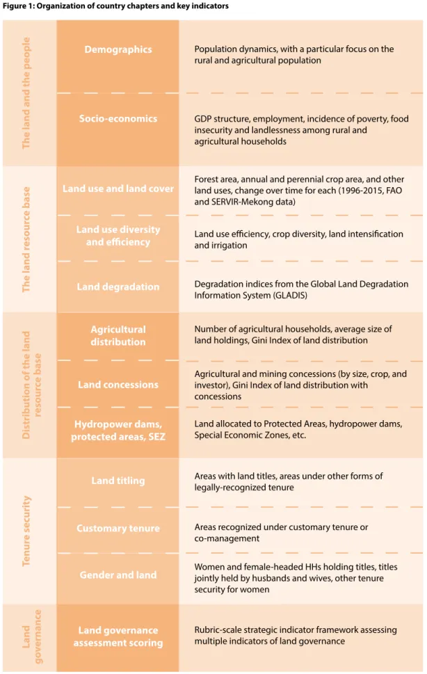
Figure 1: Organization of country chapters and key indicators ...4
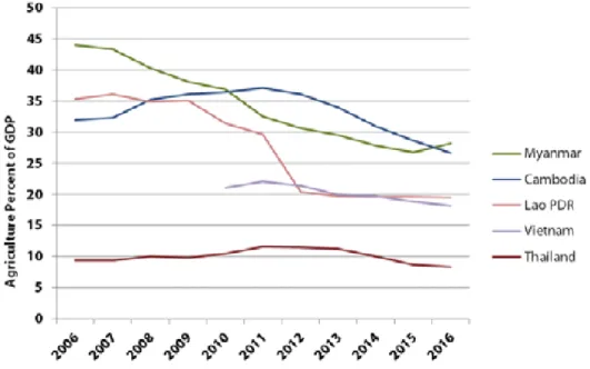
Figure 2: Change in the share of agriculture in the GDP of the Mekong countries (2006-2016) ...9
Figure 3: Cumulated annual change in agricultural land area in the Mekong region... 15
Figure 4: Change in area of main land use types in the Mekong countries (1996-2015) ... 17
Figure 5: Change in the area under agriculture and tree-crop concessions in the Mekong region (1992-2017) ... 31
Figure 6: Distribution of area under concession by crop in the Mekong region ... 39
Figure 7: Concessions in Cambodia by investor origin, by area ... 44
Figure 8: Concessions in Laos by investor origin, by area ... 44
Figure 9: Cumulated regional trade flows of land-based commodities from the Mekong region (2006-2015) ... 46
Figure 10: Exports of land-intensive commodities from Thailand and Vietnam (2006-2015) ... 47
Figure 11: Exports of land-intensive commodities from Cambodia (2006-2015) ... 48
Figure 12: Exports of land-intensive commodities from Laos (2006-2015) ... 48
Figure 13: Exports of land-intensive commodities from Myanmar (2006-2015) ... 49
Figure 14: Land embodied in exports, Mekong region ... 53
Figure 15: Distribution of land with titles, land use certificates, or other legal documents in the Mekong region ... 55
Figure 16: Distribution of land titles by sex in the Mekong region ... 60
Figure 17: Sex ratio and age class distribution in Cambodia ... 69
Figure 18: Change in urban and rural populations in Cambodia (1997-2016) ... 69
Figure 19: Change in GDP structure in Cambodia by sector ... 70
Figure 20: Land use and land cover change in Cambodia (1996-2015) ... 71
Figure 21: Distribution of main annual and perennial crop types in Cambodia ... 73
Figure 22: Change in rice cultivated area in Cambodia (2002-2016) ... 74
Figure 23: Change in rice yields in Cambodia (2002-2016) ... 74
Figure 24: Land governance assessment in Cambodia ... 82
Figure 25: Sex ratio and age class distribution in Lao PDR ... 89
Figure 26: Change in urban and rural populations in Lao PDR (1997-2016) ... 89
Figure 27: GDP structure by sector in Lao PDR (2006-2016) ... 93
Figure 28: Land use and land cover change in Lao PDR (1997-2016)... 95
Figure 29: Distribution of main annual and perennial crop types in Lao PDR ... 97
Figure 30: Number of land concessions granted in Lao PDR (1989 and 2016) ...104
Figure 31: Share of land under concession, by land use, in Lao PDR ...105
Figure 32: Share of land under concessions, by investor origin, in Lao PDR in 2010 and 2017 ...105
Figure 33: Land governance assessment for Lao PDR...110
Figure 34: Sex ratio and age class distribution in Myanmar ...117
Figure 35: Change in urban and rural population in Myanmar (1997-2016) ...117
Figure 36: Change in GDP structure by sector in Myanmar (2006-2016) ...117
Figure 37: Distribution of main annual and perennial crop types in Myanmar ...119
Figure 38: Land use and land cover change in Myanmar (1996-2015) ...121
Figure 39: Issuance of land use permit granted on VFV land (1991-2016) ...125
Figure 40: Land govenance assessment in Myanmar ...128
Figure 41: Sex ratio and age class distribution in Thailand ...139
Figure 42: Change in urban and rural population in Thailand (1997-2016) ...139
Figure 43: Change in GDP structure in Thailand, by sectors (2006-2016) ...141
Figure 44: Land use and land cover change in Thailand (1996-2015) ...141
Figure 45: Distribution of main (non-rice) annual and perennial crop types in Thailand ...143
Figure 46: Land governance assessment in Thailand ...149
Figure 47: Sex ratio and age class distribution in Vietnam ...157
Figure 48: Urban and rural population in Vietnam (1997-2016) ...157
Figure 49: Change in GDP structure by sector in Vietnam (2010-2016) ...159
Figure 50: Land use and land cover change in Vietnam (1996-2015) ...160
Figure 51: Distribution of main (non-rice) annual and perennial crops types in Vietnam ...162
State of Land in the Mekong Region IX
The Mekong region and the world: Expert viewpoint
Poverty and food security: The global situation. Sabin Bieri, Centre for Development
and Environment (CDE), University of Bern ... 13
Shifting cultivation in the Mekong region. Andreas Heinimann, CDE, University of Bern ... 21
Land disparities. Philip Hirsch, Chiang Mai University ... 28
Hydropower and land use change in the Mekong River Basin. Kim Geheb, Water, Land and Ecosystems Mekong Programme ... 36
Large-Scale Land Acquisitions (LSLAs) in the Global South. Markus Giger, CDE, University of Bern ... 42
Globalization, trade flow and land use change. Patrick Meyfroidt, Earth and Life Institute, University catholique de Louvain ... 50
Embodied land and forest resources in global trade flows. Klaus Hubacek and Kuishuang Feng, University of Maryland ... 53
Land and the SDGs. Eva Hershaw and Ward Anseeuw, International Land Coalition and the Centre de Coopération Internationale en Recherche Agronomique pour le Développement (CIRAD) ... 54
Table 1: Change in agricultural land area in the Mekong region, in millions of hectares ... 14
Table 2: Forest areas and change in the Mekong region (1996-2015) ... 18
Table 3: Agricultural, tree crop and mining concessions in the Mekong region (number and area) ... 32
Table 4: Number and area of ELC before and after Order 01 in Cambodia ... 76
Table 5: Oil palm concession areas allocated versus actually planted in Myanmar ...126
Table 6: Number of land-use titles issued in Vietnam ...170
Table 7: Percentage of men and women with names on land use rights certificate in Vietnam...173
List of tables
Perspectives: Voices from the field
Unequal distribution of land. Chan Sophal, Center for Policy Studies, Cambodia ... 78
Community Protected Areas. Mom Sary, Department of Community and Livelihoods, Ministry of Environment, Cambodia ... 81
Insecure land tenure. Florian Rock, Independent, Cambodia ... 83
Policy coherence. Thatheva Saphangthong, Department of Agricultural Land Management, Ministry of Agriculture and Forestry, Lao PDR ... 93
Open data. Chanthaviphone Inthavong, Cabinet of the Ministry of Natural Resources and Environment, Lao PDR ...101
Agrobiodiversity. Michael Victor, The Agrobiodiversity Initiative, Lao PDR ...102
Free, Prior and Informed Consent. Vanida Khouangvichit, Village Focus International, Lao PDR ...105
Tenure security in the commons. Vansy Senyavong, Maeying Huamjai Phattana, Lao PDR ...109
Legal recognition for shifting cultivation. Glenn Hunt, Land Core Group, Myanmar ...130
The National Land Use Council. U Shwe Thein, Land Core Group, Myanmar ...131
The Green Lobby in Thailand. Nattakant Akarapongpisak, College of Politics and Governance, Mahasarakham University, Thailand. ...145
SEZ development. Somnuk Jongmeewasin, EEC Watch, Thailand ...148
The Land and Buildings Tax. Teerayut Thaiturapaisan, Apex Development Public Co. Ltd., Thailand ...151
Land expropriations and the land market. Dang Hung Vo, Hanoi University, Vietnam ...168
Citizen monitoring of land governance in Vietnam. Andrew Wells-Dang, Oxfam, Vietnam ...169
The rights of ethnic minorities in Vietnam. Luong Thi Truong, Center for Sustainable Development in Mountainous Areas, Vietnam ...172
State of Land in the Mekong Region XI
List of abbreviations
ADB Asian Development Bank
AEC ASEAN Economic Community
ASEAN Association of Southeast Asian Nations
BAAC Bank of Agriculture and Agricultural Cooperatives
CDI Crop Diversity Index
EdC Electricité du Cambodge
EGAT Electricity Generating Authority of Thailand
EITI Extractive Industries Transparency Initiative
ELC Economic Land Concession
FAO Food and Agriculture Organization
FDI Foreign Direct Investment
GDP Gross Domestic Product
GLADIS Global Land Degradation Information System
GMS Greater Mekong Sub-region
GoL Government of Lao PDR
HH Household
IDP Internally Displaced Persons
IDPoor Identification of Poor Households
IP Indigenous People
KHR Khmer Riel
KIO Kachin Independence Organisation
KNPP Karenni National Progressive Party
KNU Karen National Union
KTC khana kammakarn nayobai thidin haengchat
LFA Land and Forest Allocation
LICADHO Cambodian League for the Promotion and Defence of Human Rights
LPRP Lao People’s Revolutionary Party
LSLA Large Scale Land Acquisition
LTTP Lao Land Titling Programme
LULC Land Use Land Cover
LURC Land Use Rights Certificate
MAFF Ministry of Agriculture, Forestry and Fisheries
MIME Ministry of Industry, Mines and Energy
MLMUPC Ministry of Land Management, Urban Planning and Construction
MoE Ministry of Environment
MoNRE Ministry of Natural Resources and Environment
MoP Ministry of Planning
MRLG Mekong Region Land Governance
NCDD National Committee for Sub-National Democratic Development
NCPO National Council for Peace and Order
NGO Non-Governmental Organization
NIS National Institute of Statistics
NLPC National Land Policy Committee
NMSP New Mon State Party
NTFP Non-Timber Forest Products
ODC Open Development Cambodia
PAPI Vietnam Provincial Governance and Public Administration Performance Index
SDG Sustainable Development Goal
SERVIR Regional Visualization and Monitoring System
SEZ Special Economic Zone
SFE State Forest Enterprise
SLC Social Land Concession
SLR Systematic Land Registration
TLIC Turning Land Into Capital
TLUC Temporary Land Use Certificate
UXO Unexploded Ordnance
VGGT Voluntary Guidelines on the Responsible Governance of Tenure of Land, Fisheries and Forests in the Context of National Food Security
VND Vietnam Dong
Preface
Dear readers,We are very happy and proud to welcome you to the first publication of the State of Land in the Mekong Region. This single reference document presenting the situation of land in the Mekong Region is a great example of what can be achieved with collaborative effort and the sharing of data and information.
This report tells us a lot about trends and what is happening. Equally important, it points out what is missing— what data is not available or where evidence is scarce, or conflicting. This indicates where concerted effort is needed to bridge the data and knowledge gap.
This work is based on a strong belief that quality data and sound information are vital for informed decision-making. Data should not only be accessible to government actors, but also all other stakeholders affected by and concerned with development trends in the Mekong region. Furthermore, by gathering and comparing data at the regional level, it presents a valuable tool for understanding common drivers of land use change dynamics in the region, highlighting where policies vary and result in different outcomes and perspectives.
The State of Land in the Mekong Region is the outcome of a process of knowledge co-production, critical discussion and the combined efforts of a diverse network of experts, practitioners, academics, activists and public servants from across the Mekong region and beyond. In this sense, it represents not only a remarkable product, but also exemplifies the power of collaboration and open dialogue. The Mekong Region Land Governance team, collaborators and partners are strongly committed to the project aim to “secure access to land and natural resources for smallholder farmers in the Mekong region” and we truly believe that dialogue with all concerned stakeholders is essential to reach this objective. The State of Land is an important tool to encourage conversations to help prepare a better pathway for smallholder farmers in the Mekong. It is not only full of useful and vital information and data, it is also a beautiful book with lively illustrations and striking maps that illustrate the phenomena described.
Our hope is that the State of Land in the Mekong Region will become both a reference document and a living initiative, continuing beyond its first edition in the years to come, periodically revised and updated to track key changes in the Mekong region. It is also our hope and our intention that this publication will be a catalyst for new analyses, debates and investigations.
Kate Rickersey
Team Leader, MRLG Land Equity International
Christian Castellanet
Deputy Team Leader, MRLG
State of Land in the Mekong Region XIII
Foreword
The pace and scale of change in land systems across the world are increasing rapidly. While globalization, market integration and climate change have long been with us, the acceleration of these processes in recent decades has produced profound, and often new, challenges at multiple levels. Our knowledge of the drivers of change, outcomes on the ground, and the ways in which various sets of drivers in different parts of the world interact with one another is still very limited. These limitations critically undermine our ability to support evidenced-based decision-making and foster much needed transformational change in the management of the global land system.
National and regional analyses that bring together key data and information on land—the biophysical resource, how it is changing, how it is shared, and how it is administered—are vitally needed. Equally, it is necessary to understand not only local patterns and drivers of change, but also the ways in which these intersect with regional and global dynamics. The State of Land in the Mekong Region was produced to accomplish this purpose. It focuses on the status and changes in land at national and sub-national levels in the countries of the Mekong region, and at the same time comparatively analyzes these and situates them within a broader regional and global context.
In a very important sense, the State of Land in Mekong Region is about much more than just the Mekong. This region lies at the intersection of global flows of investment in land and the trade of land-based commodities, and also exemplifies the changes that we are seeing across the world—large-scale land use change and intensification, demographic transitions, and growing disparities between the wealthy and the poor. The dynamic and emergent processes in the Mekong are both the product of global forces of change and also drivers of these changes in their own right. In this sense, the Mekong may provide some solutions as we seek to effectively grapple with the triple challenge of biodiversity loss, climate change, and human well-being. It is our hope and expectation that the State of Land in the Mekong Region will promote further dialogue around the complex issues we face today, and also that it will be a forerunner for similar efforts in other regions of the world as we work together to bring about the transformational changes needed to forge a path toward a more sustainable global future.
Professor Peter Messerli
Director, Centre for Development and Environment University of Bern, Switzerland
Executive summary
The Mekong region has undergone rapid socio-economic growth over the past two decades alongside pronounced transformations in a number of key sectors and relations between the rural majority and increasingly-affluent urban centres. Land—as both a foundation for national development and the livelihood basis for millions of rural and agricultural households—continues to play a central role in the Mekong region. In all five countries of the Mekong region—Cambodia, Lao PDR, Myanmar, Thailand and Vietnam—smallholder farmers have occupied a central role in the development of the agricultural sector and, through it, food security and economic growth. However, rural communities are being increasingly swept up into regional and global processes against which they are poorly-positioned to compete. Often, they are undermined by national policies that fail to ensure their rights or enable them to benefit.
In a region in rapid transition, understanding the changing role and contribution of land to development is critical to inform policy, planning and practices towards a sustainable future. The State of Land in the Mekong Region aims to contribute to this much needed conversation between all stakeholders by bringing together key data and information to identify and describe important issues and processes revolving around land, providing a basis for constructive dialogue and collaborative decision-making. The State of Land in the Mekong Region report is structured around five domains: (1) the land-dependent people of the Mekong, including dynamics of rurality, agricultural employment and the on-going structural processes of demographic and agrarian transitions; (2) the land resource base upon which this population depends, including land use and land cover, agricultural conditions and change, and its natural capital; (3) the ways in which this land resource base is distributed across society, including smallholdings, large-scale land investments and other designations; (4) land tenure security, which depends on how the land rights are recognized and formalized, and; (5) the conditions of governance and land administration that shape access to and control over land resources, issues of transparency, equity, the rule-of-law and access to justice. The State of Land in the Mekong Region is framed by a number of key indicators within each of these domains and presents them on two levels: At the regional-level, it presents a comparative analysis of key conditions and patterns between the Mekong countries and an examination of transboundary process that shape and define land issues, including especially regional trade and investment flows in the land and agricultural sectors. At the country-level, data and information on key indicators are disaggregated and examined to identify country-specific conditions and trajectories of change.
Given the critical role that data and information play in the identification of key issues, their accurate characterization, and the structuring of decisions and policies to address these, the State of Land also provides a critical analysis of the data and information—what is available in the public domain, what is not, and why these matter—with a view toward constructively identifying ways to improve the production, management and sharing of data and information.
State of land in the Mekong region
Each country in the Mekong region has undergone a structural transformation of its economy, generally moving away from agriculture as its dominant sector. While the agricultural sector continues to grow—in some cases impressively—its proportional share of national Gross Domestic Product (GDP) has declined across all countries due to the even more rapid growth in the industrial and service sectors. This pattern varies significantly across countries, however. In Thailand and Vietnam, urbanization and industrialization are more advanced; the share of agriculture in GDP is lower and has been more or less constant over last 25 on years. In Cambodia, Laos and Myanmar, the share of agriculture in GDP is higher but witnessed an important drop from 2010 to 2016 to 26.7, 19.5 and 25.5 percent, respectively.
The proportion of the population engaged in agriculture has also declined, but at a much slower rate and remains relatively-high (e.g. 77 percent of the workforce in Laos and 54 percent in Vietnam, though 30 percent in Thailand). This and other evidence suggest that the agrarian transition—the transformation of agriculture under the forces of urbanization and industrialization—is an uneven process that is far from complete in the Mekong region. In Cambodia, Laos, Myanmar and Vietnam, the creation of jobs in the secondary and tertiary sectors lags significantly behind growth of the active labour force in rural areas, meaning that agriculture remains a strategic job provider for the vast majority of the population of the Mekong. Thus, access to land remains a central concern in the livelihoods of rural communities. The rural and agricultural population is both dominant across the region, but also by far the most likely to be poor. For while poverty rates overall have been steadily declining across the Mekong, this is much less true for rural areas. Ninety percent of poor households in Cambodia, for example, are rural. In Thailand, the differentiation is perhaps more striking: while only one-third of households are considered rural, these comprise 80 percent of Thailand’s poor.
The incomplete character of the agrarian transition is increasingly visible in the demographics of the Mekong countries—in particular in the mobility of the rural population as people seek employment and other livelihood opportunities. Rural-to-urban migration flows are important, and related to urbanization and the opportunities afforded by growing industry and service sectors. However, these rural-to-urban migrations are dwarfed by the outsized flow of people from one rural place to another in search of land and economic opportunities, a dynamic typically under-recognized. This rural-to-rural mobility has important implications for land distribution,
State of Land in the Mekong Region XV access and tenure security. Cross-border migrations
are both rising and typically associated with rural communities, as workers—especially the young— leave agricultural communities in Cambodia, Laos and Myanmar in search of employment, most commonly in Thailand. These movements reflect the inability of rural areas to provide adequate opportunities for the young.
These economic and demographic transformations have been accompanied by dramatic changes in land use and land cover in the Mekong. Agricultural land across the region increased by more than 9 million hectares, or around 21 percent, between 1996 and 2015. At the same time, forest areas have declined, as non-forest uses (especially agriculture) encroach into remaining natural forests. These changes vary considerably by country. Vietnam has seen the most impressive expansion of agricultural land (around 65 percent), similar to patterns of agricultural expansion in (in descending order by proportion) Laos, Myanmar and Cambodia. Thailand, by contrast, experienced little change. Declining forest areas have been most pronounced in Cambodia and Myanmar, which have lost 22 and 21 percent of their forests, respectively. The expansion of agricultural land has also been accompanied by a number of changes in cropping patterns. The significant increase in the cultivated area of export-oriented commercial crops has resulted in a degree of diversity at the aggregate level, where cropping has partially shifted away from the overwhelming dominance of rice in favour of commodity crops. However, the replacement of natural vegetation and local, diversified cultivation systems has also brought about a profound degree of simplification: six crops alone—rice, cassava, maize, sugarcane, rubber and oil palm—now command fully 80 percent of all agricultural land in the Mekong. The intensification of agricultural production is another pronounced trend and, while playing a major role in the growth of the agricultural sector, also has important implications for land degradation. Arguably, the majority of the regional land area shows medium- to high-levels of degradation, resulting from the loss of natural vegetation, mono-cropping, poor soil conservation technique and cultivation on fragile and easily-erodible soils in upland areas. The erosion of the natural capital base is a pressing concern, with both immediate and long-term effects, particularly for those whose reliance on agriculture and forest resources—the poorest segment of society—is most direct.
Agricultural land in the Mekong countries is primarily under the management of agricultural households, who thus remain the most important segment of the rural population with regard to the agricultural sector and land management, despite the increasingly-visible role played by agribusiness corporations and investors. However, agricultural land is unequally distributed among these smallholder farmers. The average landholding size per agricultural household varies widely between countries, from 0.7 ha in Vietnam to 3.1 ha in Thailand. Except in Laos, the average area of landholding per agricultural household has declined over the last 10 years. Variations in land holdings within each country is larger than variations between countries. The Gini Index relating to the distribution of landholding amongst smallholder farmers is
relatively high (Cambodia: 0.47; Laos: 0.34; Myanmar: 0.48; Thailand: 0.49 and Vietnam: 0.54) and has tended to increase in all five Mekong countries. In these figures, landlessness is not adequately captured due to a lack of available data, though appears to be increasing. Case studies indicate that the inclusion of landless households would demonstrate even higher disparities in land. Importantly, the inclusion of large-scale agricultural and forestry concession operated by companies shows that the distribution between all landholders is even more uneven (with Gini coefficients in Cambodia of: 0.64; Laos: 0.49; Myanmar: 0.53; Thailand: 0.49 and Vietnam: 0.56).
With the exception of Thailand, there has been a pronounced trend in all Mekong countries since the late-1990s toward an increasing number of large-scale land investments as the governments of the Mekong countries have sought to leverage land deemed under-utilized to attract financial resources for development. The rationale is presented as self-evident: granting concessions in exchange for financial investment is necessary to turn untapped land into capital, boost the production of export commodities and stimulate opportunities for local development such as wage-labour, rural infrastructure, processing facilities and access to markets.
Though some occurred earlier, large-scale land investments in the Mekong began in earnest around 2006, and were further stimulated by the global financial crisis (2008), as rising food- and fuel-costs and risks associated with financial markets prompted global investors and agribusiness companies to invest in the Mekong’s emerging land market. Until 2011, the granting of land concessions was in full-swing. As a result, the agrarian structure of the Mekong countries has been considerably transformed. In total, 4.1 million hectares of land have now been granted to companies under various concession agreements in the agriculture and tree plantation sector. In Cambodia, Laos and Myanmar, land concession areas represent, respectively, 37, 30 and 16 percent of the total area cultivated by smallholder farmers. Concessions of land in the mineral sector are substantial and, including exploration concession areas, likely outsize agriculture and forestry concessions. With the exception of Laos, a lack of available data limits assessment.
Most of the area under agricultural concession is devoted to the boom crops—rubber, sugarcane, oil palm, cassava and maize—that represent 76 percent of concession areas across the region. An important dimension of the concession landscape in the Mekong is the transboundary nature of investments and associated trade-flows between the Mekong countries themselves and their near-neighbours. While a significant amount of investment in land concessions is driven by domestic investors (43 percent in Cambodia and 31 percent in Laos), the second largest group are investors from China, Vietnam, Thailand and South Korea (together accounting for 36 percent of total concessions in Cambodia and 60 percent in Laos). Vietnam and Thailand function both as investors in large-scale land deals and importers, processors and exporters of the commodities associated with them. China is, by far, the largest end-market for regional exports of agricultural commodities.
© Heidi Ingalls
State of Land in the Mekong Region XVII In the main, the hoped-for benefits of these land
investments have not been realized. While playing a role in rising GDP in host countries, state revenue has been less than anticipated and the social and environmental costs of these developments have generally exceeded their benefits, and have largely been borne by the rural poor. Fundamental to the problem has been an under-recognition of land tenure and local uses prior to acquisition. The dispossession of rural households from land concession areas accompanied by inadequate compensation—where such has been provided at all—has had a particularly negative impact, clearly at odds with the stated purposes of land-investment based development strategies. The lack of return on these investments has prompted concerns among policy-makers across the region. In 2012, Laos and Cambodia both issued limited moratoria on new concessions. Processes of land conflict resolution have been activated but a particular point of concern in Cambodia, Laos and Myanmar revolves around the cancellation of concessions that are not performing or meeting their obligation. The underlying question is whether these areas will be maintained as State land and given new State-managed functions or if they will be redistributed to farmers and communities. The tensions are clearly palpable and the future of concession-based development is uncertain.
The well-being of smallholders and their ability to gain benefits from their agricultural land depends to a large extent on the security of their tenure. Land titling and land use certificates are considered principal ways to provide formal legal recognition and tenure security against conflicting claims, and to serve as collateral for loans. Land tenure formalization is most advanced in Vietnam, Thailand and Myanmar, though in the latter two of these countries titling tends to exclude large parts of the forest estate, a situation found also in Laos.
Beyond the titling of individual parcels, existing legislation and policies of the Mekong countries offer various forms of recognition of customary tenure. Despite supportive legal frameworks, the practical application of granting collective title on communal landholdings under customary tenure arrangements has been slow, weak and irregular. The situation is particularly problematic in Myanmar where legislation has been generally regressive, providing no clear legal protection for customary tenure in shifting cultivation systems. Alternatively, a variety of co-management arrangements have been used across the Mekong as mechanisms to support traditional local claims over land and natural resources.
In response to structural changes in the land and agricultural sectors and the rapid changes in investment and commodity-flows brought about by the globalization of financial- and market-systems, the governance of land resources in the Mekong is undergoing a period of transformation previously unseen. The environmental and social impacts of large-scale land acquisitions and the rapid growth of land markets have triggered social unrest, raising concerns among policy makers resulting in—in some contexts—policy responses such as moratoria (above), improved environmental and social impact assessment and compensation processes, and the prioritization
of high-quality investments (those with relatively better social and environmental performance). Alongside these policy and regulatory changes, what has been arguably most pronounced across all Mekong countries is the large gap between these and the practice of land administration. Corruption and a lack of public accountability remain key obstacles to addressing the critical problems surrounding land issues. The expropriation of land by the state for the promotion of investments has continued to struggle with the ambiguous nature of specific land-deals promoted for public purpose but often developed for private benefit. Closely related to these issues, the past decade especially has seen significant changes in civil society in the Mekong and the degree to which civil society organizations are able to effectively address land-related issues. These changes include both a degree of opening as well as a degree of closure, often in the same countries. In addition to a general lack of rights for civil society organizations in some of the Mekong countries, of particular concern has been the recent clamping-down on such groups, often in response to political changes and uncertainties surrounding public corruption and land-related investments.
The rights of indigenous peoples and ethnic minorities to land and other resources vary widely across the Mekong. While national legislation in each country commonly includes provisions to ensure either specific protections and rights related to minorities by dint of their ethnicity, or general provisions to safeguard equal access to rights and resources regardless of ethnic status, such provisions have generally not been sufficient to enable indigenous peoples and ethnic minorities to retain rights to their land or to protect traditional practices, such as shifting cultivation. Similarly, while the rights of women and female-headed households are typically enshrined in legal frameworks, there remains a need for significant improvements with regard to their protection in practice. A lack of gender-disaggregated data and information on tenure security for women is a key obstacle to consistent monitoring.
The Mekong is in the midst of substantial, far-reaching transformations with regard to land. The region is thus at a critical juncture wherein robust, inclusive and accountable decision-making are urgently needed. The continued dominance of regional and global financial- and commodity-markets suggests that the direction the Mekong countries take with regard to key land-related issues will be shaped in some measure by outside influences. The path forward depends on the degree to which these forces can be leveraged for the benefit of the rural and agricultural majority, rather than for the few. Whether the region is able to steer a course toward a more sustainable and inclusive future remains an open question, the answer to which will decide the future of the Mekong and its people.
State of Land in the Mekong Region Introduction 1
Introduction
Introduction
The Mekong region lies at the intersection of Southeast, East and South Asia, in-between two Asian giants: China and India. It is named after the eponymous river that originates on the Tibetan plateau and runs through China and mainland Southeast Asia. Five countries—Cambodia, Lao PDR, Myanmar, Thailand and Vietnam— comprise the bulk of the greater Mekong watershed.
The Mekong region is exceptional for its rich social and ecological diversity. It is home to 237 million people, from approximately 329 ethnic groups and who speak 410 distinct languages (Lewis, 2009), making it one of the most ethnically-diverse places in the world. The Mekong is also a global biodiversity hotspot (Tordoff et al., 2012) and home to a large number of species of global significance (WWF, 2013).
The Mekong countries share similar agrarian structures and intertwined histories of agrarian change (Hirsch and Scurrah, 2015). After independence from European colonial rule1, under different political-economic
modalities and varying degrees of socialist experiment, the states of the region promoted an agricultural development model based on the agricultural household2 as a basic unit of production and management.
These countries are currently undergoing similar land reform agendas that aim to turn land into capital through large-scale land investments alongside the formalization of land tenure rights and the development of a dynamic land market.
Smallholder farmers in the Mekong region are increasingly influenced by regional dynamics of economic development, cross-border investment, and trade flows. In fact, the region has become a global centre of production and trade for agricultural and forest commodities such as rubber, rice, cassava, wood, sugar cane and oil palm, meaning that regional dynamics and change have a significant global impact, and vice versa. These dynamics are triggered in part by regional agro-food conglomerates and the expansion of trade and investment treaties and partnerships, such as the ASEAN Economic Community.
The region, while rapidly industrializing and urbanizing, remains predominantly rural; roughly 61 percent of the population, or 145 million people, live in rural areas and the vast majority are engaged in agriculture. This rural and agricultural population continues to grow. In general, they are disproportionately poor due to heavy reliance on land and forest resources that are threatened by a variety of largely anthropogenic drivers of change including deforestation caused by agricultural conversion, logging and illegal timber trade, wildlife trade, overfishing, dam and road construction, and mining (WWF, 2013).
Understanding the status of the land and the people who depend on it is critical to effectively navigate change, proactively grapple with uncertainties, and address persistent problems of governance to ensure a more sustainable future. In order to inform policy, planning and practices, robust data and evidence are needed. The State of Land in the Mekong Region’s first objective is to address this need in some measure, by bringing together data and information that provide an overview of key priorities surrounding issues related to land. Yet, information about the status of land and natural resources—their condition, distribution, trajectories of change and the governance arrangements that shape their management—is often lacking, inconsistent, contested and difficult to access. Information that is available has been hampered by country- and sector-specific reporting, irregular production and sharing, and persistent issues with transparency at multiple levels. A second objective of The State of Land in the Mekong Region is thus to critically examine dataset availability (their level of aggregation, reliability, comparability across countries, etc.), identify their gaps and limitations, and identify mechanisms for improvement.
The State of Land in the Mekong Region is a starting point along a path toward fostering more open and accessible information for the benefit of smallholder farmers, government agencies, development partners and international organizations focused on land issues, and civil society groups that support regional lives, livelihoods, and natural resources.
Diverse actors and societal institutions have claims on the land resource base. However, this report explicitly focuses on the basic social unit of production, dependence, and use: the agricultural household. This focus is intentional and purposive, recognizing that this group who depends on the land and its resources is often the most marginalized in decision-making processes that impact them.
1 Except Thailand, which was never formally colonised.
2 We use the terms smallholder farmers and agricultural households interchangeably while referring to nuclear or extended families that allocate all or part of their workforce to agricultural activities in order to meet their livelihood needs. Smallholder farmers cultivate their own land or work as agricultural wage laborers. The land they access and use varies in size but is relatively small in comparison with larger land schemes operated by companies and big entrepreneurs.
State of Land in the Mekong Region Introduction 3
In
tr
oduc
tion
The report consists of six main chapters, plus this introduction and a short conclusion. The first chapter provides an overview of the region and a comparative analysis between the Mekong countries, including a section on patterns of regional trade and investment and how these shape land use and land relations. This regional chapter also includes a number of thematic boxes that seek to situate key conditions and phenomena in the Mekong within the global situation. The next five country-specific chapters provide detailed national and sub-national information on key land-related issues in Cambodia, Laos, Myanmar, Thailand and Vietnam.
To facilitate the navigation and comparison across country assessments, the structure of each chapter is similar (Figure 1). First, each chapter opens with an overview of important demographic parameters and key socio-economic challenges, particularly in relation to land-based production and employment. Second, the land resource base is presented with time series and updated information on land use and land cover. This is complemented by an analysis of the current diversity of crop cultivation at national and
sub-national levels and an evaluation of land intensification and degradation processes. Third, we present the distribution of land resources between stakeholders; for example, land possessed by agricultural households, land granted by the State as concessions, protected areas, dams, etc. Fourth, each chapter examines the ways in which agricultural household tenure rights to land and natural resources are secured through titling, recognition of customary tenure, co-management agreements, land use planning, etc. The tenure security of indigenous peoples and women is given particular attention. Fifth, we assess land governance at the country level, using a strategic indicator framework informed through a series of national consultations involving government authorities and representatives from civil society, development agencies and academia3. Finally, the
report provides concluding remarks and synthesis, suggesting ways forward that strengthen land-related data management. A methodological annex presents further information on the sources, strengths and limitations of the data used as well as more specific examination on several synthetic indexes computed and presented in the report.
3 Land governance consultations were carried out in each of the five Mekong countries, involving 104 experts and
representatives, see Annex
Figure 1: Organization of country chapters and key indicators
The land and the p
eople
Demographics
Land use and land cover
Land titling
Land governance
assessment scoring
Agricultural
distribution
Land degradation
Gender and land
Hydropower dams,
protected areas, SEZ
Land use diversity
and efficiency
Customary tenure
Land concessions
Population dynamics, with a particular focus on the rural and agricultural population
GDP structure, employment, incidence of poverty, food insecurity and landlessness among rural and
agricultural households
Forest area, annual and perennial crop area, and other land uses, change over time for each (1996-2015, FAO and SERVIR-Mekong data)
Areas with land titles, areas under other forms of legally-recognized tenure
Rubric-scale strategic indicator framework assessing multiple indicators of land governance
Number of agricultural households, average size of land holdings, Gini Index of land distribution
Land use efficiency, crop diversity, land intensification and irrigation
Areas recognized under customary tenure or co-management
Agricultural and mining concessions (by size, crop, and investor), Gini Index of land distribution with
concessions
Degradation indices from the Global Land Degradation Information System (GLADIS)
Women and female-headed HHs holding titles, titles jointly held by husbands and wives, other tenure security for women
Land allocated to Protected Areas, hydropower dams, Special Economic Zones, etc.
The land r
esour
ce base
D
istribution of the land
resour
ce base
Tenur
e securit
y
Land
go
vernanc
e
Socio-economics
State of Land in the Mekong Region Introduction 5 In tr oduc tion
References
1. Hirsch, P. and Scurrah, N. 2015. The Political
Economy of Land Governance in the Mekong Region. Vientiane: Mekong Region Land
Governance.
2. Lewis, M. P. (ed.) 2009. Ethnologue: Languages
of the World. 16th ed. Dallas: SIL International. Available at: https://www.ethnologue.com/. 3. Tordoff, A. W., Bezuijen, M. R., Duckworth, J. W.,
Fellowes, J. R., Koenig, K., Pollard, E. H. B. and Royo, A. G. 2012. Ecosystem Profile:
Indo-Burma Biodiversity Hotspot Indochina Region. Critical Ecosystem Partnership Fund.
4. WWF. 2013. Ecosystems in the Greater Mekong:
Past Trends, current status , possible futures. Bangkok, Thailand. Available at: wwf.panda.org/
greatermekong
State of Land in the Mekong Region The Mekong Region at the Crossroads 7
The Mekong Region
The Mekong region at the crossroads
Introduction
Despite important differences between the countries of the Mekong, there is a number of shared features and dynamics of change that provide a fabric of coherence, allowing us to speak of this as a region. As the regional designation suggests, the countries share portions of the Mekong River Basin, of which the countries’ territories comprise the largest share. Each of the countries also shares some topographic similarities, having large lowland areas with fertile soils along the floodplains of the Mekong and other rivers. Historically, the productivity of these lowland areas has played a key role in shaping the distribution of wealth and power. Large ethnic groups like the Tai, Kinh, Khmer and Burmese dominate lowland areas along the Mekong and its major tributaries with strong economic- and trade-linkages. Growing urban populations have enabled these groups to secure a disproportionate amount of wealth and political and military power. Upland areas are typically dominated by ethnic minorities, many of whom are generally poorer, less politically powerful, and engage in subsistence and traditional forms of agricultural production. In the main, these peripheries have remained on the margins of the central polities, receiving fewer benefits from the region’s economic and agricultural transformations, but arguably bearing more of its costs.
The political history of the region points to key commonalities between the Mekong countries, though each diverges in terms of engagement with European colonisation4 and state-making pathways. Each of the Mekong
countries also shares important similarities with regard to agricultural production, dominated historically by rice but in contemporary times grappling with the emergence of large areas of land under non-rice commodity crops that are increasingly integrated into the global market economy.
However, there are stark differences between the Mekong countries. The Human Development Index (HDI) scores reflect these general variations. Thailand and Vietnam stand out with regard to overall higher levels of development, whereas Laos, Cambodia and Myanmar fall behind (Map 1). The HDI takes into consideration aggregate levels of development across a number of key development domains at the national level. What is perhaps more significant is that differences between the Mekong countries with regard to development are less pronounced than sub-national differences within each. At the sub-national level, development disparities between the economically vibrant urban centres and the rural peripheries are substantial.
Map 1: Human Development Index in the Mekong region
4 Except Thailand, which was never formally colonised.
5 Human Development Index Reports, available online at: http://hdr.undp.org/ Data source: HDR-UNDP5
Human Development Index
Rank out of 188 Countries Thailand 83rd Vietnam 116th Lao PDR 139th Cambodia 146th Myanmar 148th
State of Land in the Mekong Region The Mekong Region at the Crossroads 9 The M ekong R eg ion a t the C rossr oads
The land and the people: Agrarian
transitions and unevenly shared
growth
Economic transformations and the role of
agriculture
The Mekong countries are in the midst of agrarian transition—characterized by a decreasing reliance on primary sectors and a growing shift toward service- and industry-sectors. However, the position of each of the countries along this trajectory of change varies greatly (Figure 2). Despite this transition, agriculture remains foundational to national development and food security, especially for the rural majority.
Figure 2: Change in the share of agriculture in the GDP of the Mekong countries (2006-2016)
In each country, agricultural production has grown considerably over the last decade, but at a much slower pace than other sectors. As a result, the contribution of the agricultural sector to overall GDP has contracted. In Myanmar and Lao PDR, agriculture’s share in GDP has declined sharply (by 16 percent) between 2006 and 2016. Cambodia saw an increase in the share of agriculture in overall GDP during some of these years, but a final decrease of 5 percent relative to 2006. Thailand remained fairly stable, albeit with a small (1 percent) decline between 2006 and 20167.
Amid rapidly growing national economies and a retracting share of agriculture in this growth, the persistence of large agricultural populations is significant. In Lao PDR, for example, while nearly 80 percent of the workforce is in agriculture, the sector’s
6 FAO Statistics Division, available at: www.fao.org/faostat 7 The data of the contribution of agriculture is taken from the
World Bank’s global databank that aggregates data from national sources. The values are comparable among the five countries. However, it is important to bear in mind that the real contribution of agriculture is usually underestimated in macro-economic measures of GDP. The part of the production that is directly consumed within the household is not fully taken into account, nor are the many subsistence activities associated with common pool resources. The multiple contributions made by women are particularly under-estimated (Charmes 2000).
contribution to overall GDP is below 20 percent. This is perhaps the most striking case of a wider dynamic of the Mekong region: the rural and agricultural population is falling behind, generally failing to reap the benefits of the region’s economic growth. In 2016, the agricultural population in Vietnam has a similar, if lower, majority, at nearly 54 percent. This stands in stark contrast to Thailand, the Mekong country in the most advanced stage of its agrarian transition, where less than 30 percent of its population is employed in agriculture (down from 65 percent in 1990). However, these national averages mask important sub-national differentiation (discussed in the country chapters that follow).
Interpreting the data: The challenge
of measuring employment in
agriculture
The rate of employment in agriculture is a national-level estimate value given by the International Labour Organisation (ILO) Statistics (ILOSTAT) for each country. It is considered as the number of people (expressed as a percentage of total labor force) that are engaged during the year in any activity in agriculture, hunting, forestry and fishing. It is not always clear whether this implies that these comprise the primary source of income. The data is also not consistent with national datasets. In Cambodia, for instance, employment in agriculture was 27.4 percent whereas the commune database updated annually by local authorities indicates that in 2016, 68.8 percent of people older than 18 years old were engaged in agriculture, fishing and NTFP collection as their primary or secondary form of livelihood.
Despite sustained declines in the share of agriculture’s contribution to GDP, the rates of agricultural employment in Cambodia, Laos, and Myanmar remain high, indicating that the agrarian transition is far from complete, as the transfer of labor away from agriculture to industries and service sectors is not keeping pace with the growing labor force in rural areas. In these countries, the challenges of increasing agricultural productivity and ensuring access to land thus remain at the core of sustainable rural development.
A growing and mobile population
The Mekong region as a whole is in the midst of a demographic transition as education, changing social norms, economic opportunities, and urbanization have led to declining fertility and mortality rates and an ageing population base. Yet, each country is at a very different stage along this transition. While Thailand and Vietnam are beginning to face an increasingly older population that is shifting out of economically-active life stages, Lao PDR, Cambodia and, to some extent Myanmar, are benefitting from the so-called “demographic dividend,” as recent declines in fertility rates have led to a large proportion of the population in the work force, most of whom depend primarily on agriculture.
The total population of 237 million people in the Mekong region has a highly uneven distribution. Vietnam, the most populous country in the Mekong, is home to more people than Lao PDR, Cambodia and Myanmar combined, while urban centres like Bangkok, Hanoi and Ho Chi Minh each have a population greater than the total population of Lao PDR, the least populous country in the region. Despite these differences and the existence of large urban metropolises, the Mekong remains predominantly rural with only Thailand having less—but only slightly less—than half of its population in rural areas (Map 2 and text box).
While predominantly rural, there are important— though generally modest, at around 1 percent per year—urbanization trends across the region (see country chapters), due both to the upgrading of rural villages to urban towns and the migration of rural populations to urban centres as they seek to benefit from the economic growth of these areas and the employment opportunities they provide. While these rural-urban migrations have received significant attention, they pale in comparison to larger trends in rural-rural migration across the region. In Cambodia, Laos and Myanmar, especially, the number of people moving from one rural area to another is significantly more important than the number of those moving to urban areas. Even in Thailand, where the draw of urban centres is comparatively strong, rural-rural migrations still outsize those to cities. In the main, this rural-to-rural migration stream is autonomous and driven primarily by the search for agricultural land and rural employment opportunities. It can be seen as a strategy by agricultural households to escape poverty and improve their means of subsistence.
Interpreting the data: Measuring rural
population
The proportion of the population living in rural areas directly depends on the degree of urbanization given by the percentage of population living in urban areas. The definition of an urban area is based on specific criteria established by each country according to their context. The extent of urbanization also depends on the geographic scale at which it is measured. Different, country-specific criteria for measuring urbanization make it difficult to compare the situation of one country with another, and thus these comparisons may be partially misleading.
Map 2: Proportion of the rural population in the Mekong region
Alongside these internal migrations, international migrations are also significant. Thailand absorbs a substantial number of migrants from neighboring countries, possibly as high as 5 million people, the majority of whom are young and from rural and agricultural communities from Cambodia, Laos and Myanmar (IOM 2016). While many migrate to large cities, others also seek agricultural employment, taking advantage of Thailand’s seasonal agricultural labor shortages or work in Thailand’s marine fisheries industry. These movements are significant for several reasons, not least because the majority of these international migrants are drawn from rural areas in their countries of origin where agricultural employment opportunities have lagged behind those of other sectors, failing to retain the young or provide Data sources: