Any correspondence concerning this service should be sent
to the repository administrator:
[email protected]
This is an author’s version published in:
http://oatao.univ-toulouse.fr/n° de post 19086
To cite this version: Marantos, Charalampos and Paraskevas,
Iosif and Siozios, Kostas and Mothe, Josiane and Menou, Colette
and Soudris, Dimitrios FabSpace 2.0: A Platform for Application
and Service Development based on Earth Observation Data. (2017)
In: 6th International Conference on Modern Circuits and Systems
Technologies (MOCAST 2017), 4 May 2017 - 6 May 2017
(Thessaloniki, Greece).
Official URL:
https://ieeexplore.ieee.org/document/7937657/
DOI :
http://doi.org/10.1109/MOCAST.2017.7937657
Open Archive Toulouse Archive Ouverte
OATAO is an open access repository that collects the work of Toulouse
researchers and makes it freely available over the web where possible
1School of ECE, National Technical University of Athens, Greece 2Department of Physics, Aristotle University of Thessaloniki, Greece
3University of Toulouse III Paul Sabatier (UPS),
Toulouse, France
4Corallia/Research Center Athena, Athens,
Greece
Abstract—The goal of FabSpace 2.0 project is to transform Universities to Open Innovation Centers for their corresponding region and improve their societal contribution to the socio-economic and environmental performance. For this purpose, the project provides to students, researchers, as well as to citizens or even companies, with a framework and a digital platform which gives open access to a range of geodata, i.e. Earth Observation data, but also computing and visualization tools. By this way, it is expected that the participants can work in an open co-working space, where they can interact with each other. Additionally, the participants will be assisted to assess the business aspects of any potential idea. The outcome of such an activity is the increase of possibility for participants to find a revolutionary concept, which can result to new and sustainable applications and/or services. Moreover the target group exceeds the usual Earth Observation professionals, and focuses also in professionals of other disciplines, where the use of Earth Observation data can create novel technologies.
Keywords— Fablab, FabSpace, Earth Observation I. INTRODUCTION
FabSpace 2.0 aims at making universities open innova-tion centers for their region and improving their societal contribution to the socio-economic and environmental per-formance. It concentrates on one innovation area with high expected socio-economic and environmental impact: geodata-driven innovation, by leveraging space data in particular. By enabling universities as co-creators of a new innovation scene, developers from the civil society, industry or the academic research, public administrations and civil organizations can meet, set up a creative environment, work together and finally co-create new tools and business models.
Beyond business issues, innovation possibilities are huge in the field of satellite data applications given that the Galileo and Copernicus satellite programs are entering their operational phase, [1]. Thanks to these massive investments in technology, European companies will benefit from the increase of regular and cheaper (if not free of charge) data flows, which could lead to the development of new and innovative applications and services in an incredibly vast range of markets, including (and in a large part focusing on) non-space markets.
Important role to this activity is assigned to a new kind of innovation framework, coined the term fab labs. A fab lab is a one-stop shop access to any materials, machines and tools to digitally manufacture new products. In this particular project, the term is altered to the more descriptive term, “FabSpaces”.
A FabSpace is a one-stop shop-access to a range of data (including space data), free software & data processing tools, to develop new applications.
The consortium of FabSpacce 2.0 project consists of 15 partners, distributed within the European Union (in France, Germany, Poland, Belgium, Italy and Greece). Currently, one FabSpace has been created per participant country, providing free-access services and a hub dedicated to collaborative data-driven innovation. This number is expected to be increased to 13 at the end of the project (early2019). Through online sup-port, entrepreneurship and innovation leadership trainings for students and researchers, the human capital among FabSpace users will enhance its Earth Observation (EO) data exploitation capabilities.
The objectives of FabSpace 2.0 project are summarized as follows, [2]:
• Set up and operate at universities a free-access place and service where students, researchers and external users can make use of a data platform and design and test their own applications.
• Train users to improve their capacity to process data and develop new applications/services related to geodata. • Network students, researchers, entrepreneurs, project
managers in industry and public authorities consolidate user needs and industry requirements, foster the co-creation of new innovative solutions, support further business development and creation of new start-ups. • Exploit, sustain and disseminate the concept by
demon-strating financial sustainability options for these new university services.
II. IMPLEMENTATION APPROACH
The exploitation of EO data is still limited to specific inter-est groups, mainly of purely scientific purposes. However, the paradigm shift already achieved by the Copernicus program, [1], creates valuable opportunities for the public to exploit EO data for countless applications and services. In order for this to be achieved, not only the professionals in the EO area have to widen their perspectives, but mainly it must be possible for virtually anybody to be able to harness the usefulness and multitude of the results of the EO data processing. To this end, a training approach, especially to people not trained in the EO discipline, has to be developed, where interested individuals,
FabSpace
2.0: A Platform for Application and Service
Development
based on Earth Observation Data
public organizations, companies and industry in general, can understand how to acquire, process and present EO data, how to integrate them in non-EO applications and services in order to upgrade their efficiency, and last but not least, how to assess potential business opportunities. FabSpace 2.0 aims to cover all these aspects.
A. Training in Innovation Leadership Knowledge
Researchers need better innovation leadership knowledge to foster their impact on the production of innovation. In each region covered by the consortium, universities will work closely together with business and innovation support partner organizations (AV in France, BIC Lazio in Italy, WSL in Belgium, Cesah (ESA BIC Darmstadt) in Germany, OPGK in Poland, Corallia in Greece) in order to enlarge the offer of topic-based training days linked with innovation leadership. These training days will enable business and innovation sup-port partner organizations to train researchers. Academic pro-fessors on innovation leadership will be invited to contribute to these training days as well. Such local collaboration will enable to develop relevant solutions taking into account life-long learning policies in each country and institution. Trained researchers are expected to get increased innovation leadership knowledge and will be invited to become FabSpace users to complete their training program with a learning by doing activity. In each region, a training program shall be integrated in the offer of topic-based training programs for life-long learning of researchers.
The main topics of these programs offer the necessary knowl-edge and expertise to professionals in the areas of company strategy, IT management strategies and innovation manage-ment. With respect to the last subject- innovation management and leadership, the training programs focus on teaching the development of a business plan regarding an innovative idea/ project, the best-practices for innovation leadership, how to incorporate new IT and communication technologies with the optimum way strategically within a business plan, how to use the appropriate economic models and how to design a viable entrepreneurship model for an innovation. With this respect the training program is separated in 4 main sections: (a) Innovation management/ leadership and strategic use of new technologies,(b) Marketing and promotion, (c) Finance and (d) Leadership.
It is a common case that in many technical universities the training programs regarding innovation leadership are not consistent, if exist at all. Focused mainly on the technical aspects, these universities offer some lessons on entrepreneur-ship, marketing and management, but in a way that cannot promote efficiently the necessary knowledge. Additionally, there is no clear connection of the technical subjects with research, innovation and entrepreneurship.
In order to address to researchers and have a life-learning local program the co-organization with a local BIC was necessary. However, the training sessions are designed in a way that do not simply present plain information in the form of lectures, but on the contrary, they offer hands-on experience
to the candidate start-uppers and researchers. The training shall be specifically tailored to familiarise young scientists and engineers with business aspects, while at the same time it keeps their interest high; It is common for technologists to get easily bored by plain business lectures, however they should get the necessary information and support in order to get used with the required tools and techniques for the development of their idea into a company. This is a difficult trade-off to tackle. Additionally, several parameters like the expertise of the university or the local requirements in terms of educational gaps also have to be taken into account.
To this end, innovation management lessons have been com-piled within a framework where there is the necessary amount of technical information but not with a very deep analysis. Thus, existing graduate technical lessons will be enhanced by the introduction of an appropriate number of the innovation management lessons as discussed previously.
B. Outreach Policy
For the successful outcome of the project, it is important to focus also on the outreach activities both within and outside the project framework. To this end, a number of activities have been planned, which include among other: (a) open days to academia, industry and public, where the capabilities of the exploitation of EO data and FabSpace specifically are pre-sented, (b) Space Applications Shops, where workshops with stakeholders will allow the definition of everyday challenges that can be solved using EO data and (c) Hackathons, where interested individuals form teams to solve the challenges and compete locally and internationally in two stages. Simultane-ously, members of the consortium (including ICCS and Coral-lia in Greece) have already applied and awarded to become members of the Copernicus User Uptake Activities issued by EU, specifically to become members of the Copernicus Relay Network and the Copernicus Academies ( [3], [4], [5] and [8]).
III. EO DATA & SOFTWARE AND FABSPACE PLATFORM
In order to understand the value of EO data, the users must be able first of all to find the necessary data, and secondly to manipulate them via specialized software.
A. EO Data within the FabSpace 2.0 Framework
Indeed, one major issue to be tackled is to learn how to find the necessary data needed for a specific application or service. As EU estimates, only by Sentinel satellites, 10 PB of data will be received per year, [6]; if other sources of data are also included, this figure gets even larger. Thus it is difficult, especially for a non-EO user, to get easily used on where and how to find the data needed.
The FabSpace 2.0 framework tries to mitigate this problem by giving access to an interested user to a number of sources and the main instructions on how to detect the information re-quired. Additionally, the FabSpace network aspires to connect not only the six regions of the consortium but also to create more hubs within these regions and outside of it. This way,
a large number of EO specialists will have the opportunity to connect and interact at a single point, the FabSpace 2.0, and at the same time provide information to any interested individual. Note that due to the free data policy that EU implements in the use of EO data,[7], the main business opportunities are transferred from selling images and data to the exploitation of these, and the creation of new business markets on the sell of services rather than of the raw data. Another interesting point, is that the FabSpace platform allows the easy categorization of data and metadata, something that will allow the users to find more easily local data of interest at each region. B. EO Software within the FabSpace 2.0 Framework
There is a large number of software programs for the pro-cessing of the EO data, both free and commercial, like QGIS, Monteverdi, GRASS, etc. It would be of course impossible to include and learn all these tools. The goal of the FabSpace 2.0 is to become a single point of training for the wider public, where interested people can find various EO programs pre-installed in order to experiment themselves and get acquainted with the software they think it suits them most. Moreover, within the FabSpace 2.0, it will be given the opportunity for companies to install their full or limited versions of their proprietary software, and train people on their use. This is important, especially for students, as they will learn to use and add to their resume the knowledge of a multitude of different EO software, while on the same time the companies will have the ability to make aware to a wider audience their products. Thus, a future pool of potential customers or personnel will be created.
The FabSpace platform will give also the opportunity to the users to process data, including the capability of presenting the results even at smartphones. In Section IV a more thorough example on the use of the platform is presented. Finally, it must be noted that the overall goal of the FabSpace 2.0 is to make the use of EO data available to people who are not professionals in this sector, but merely professionals and students in other areas and they have found that the use of EO will certainly give to their idea, product, service, application a certain edge by incorporating the exploitation of EO data. Thus, other market sectors (like energy, robotics, finance, health, etc.) will be targeted.
IV. USECASE EXAMPLE
This section provides a short description of some basic functions that the platform provides and a simple usecase example using the FabSpace platform and other popular GIS (Geographic information system) software, as long as other programming tools, languages and libraries. The example here is inspired by [9] refers to the suitability for swimming at the beaches of Greek island Aegina according to the National Ecological Research Center (PA.KOE) in May and June 2016 [10] .The platform is based on GeoServer[11].
A. Users And Rights
New users can ask for an account in FabSpace platform filling an account form. The administrator of the platform
validates the account and creates groups of users. There are roles assigned with user groups and rules assigned with actions to workspaces (read, write) that are included in each role. That’s the way to provide rights to the users, and allow certain users to have access to certain EO data; this is necessary in order to avoid any Intellectual Property (IP) problem, if such limitations on specific data exists.
B. Add/Manage Data to the Platform
There are workspaces that include stores. Stores are datasets (raster files, shapefiles, databases etc). There is also the feature for adding metadata connected with the data. A store can include multiple layers for the viewer. In publishing of the layers the user can also have different presentation styles. All these features can be created, managed and modified in the ’Services’ page of the platform. In this example, using QGIS, a shapefile with the Aegina’s beaches has been created from a CSV file with specific geodata information and using PostGre/PostGIS for selecting data. A workspace has been created in the platform and a new store (shapefile) has been uploaded. Then a new style with icons for beaches for the publishing layer has been also created.
C. Platform viewer
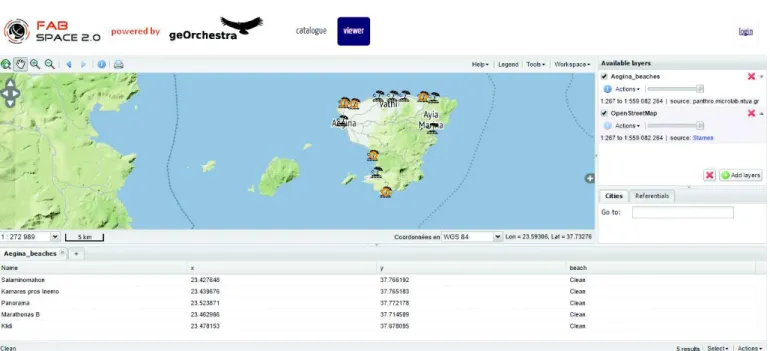
The viewer is the home page of the platform. Here the user can add layers or if logged in one can edit layers, make queries or use other functions. In our example the Aegina’s beaches layer is added to the viewer. A query to see the ”clean” beaches can be also made in this case. In Figure 1 the layer on the viewer and the result of the query are presented.
D. Web Services / Web mapping
Web mapping is the process of using maps created by GIS and delivered on the web. With web mapping applications one can display data and select layers or often make data analysis of more rarely enter and modify data. The platform offers the following web services[12]:
• WMS (Web Map Service): A way to request and serve map images and visualize them directly in GIS or web pages. The Styled Layer Description (SLD) is a descrip-tion that allows the WMS flow data formatting.
• WFS (Web Feature Service): A protocol for geographic features serving across the web (geometry and feature attribute values) and it is used for the vector data • WCS (Web Coverage Service): Allows to receive the
geographic information as grid data (coverage)
• WPS (Web Processing Service): Standardizes the calls and responses to treatment of web-based GIS data ser-vices
• Other data formats like GeoJSON, KML etc are also offered.
E. Web Applications / Android
In this example a web application and an Android appli-cation using the data that were uploaded on the platform is presented, see Figure 2. For the web application Openlayers
were used [13], which is an open source JavaScript to put dynamic maps on a page. To add the data, the WMS service (all data as a raster) and WFS service (vector data) were used. The use of WFS gave the ability to make some functions like different icons for clean and unsuitable beaches and pop-up windows with related information. The links for the services are found in the ’Layer Preview’ section of the Platform. For the Android application, the Android Studio/ Java and Mapbox was used [14]. For delivering the data from the platform the GeoJSON which is a data format for representing geographical features giving all the information in a structure was used.
V. CONCLUSION
The objectives of FabSpace 2.0 project is presented at this paper. This activity aims to provide to students, researchers, as well as to citizens or even companies, with a framework and a digital platform which gives open access to a range of geodata, such as Earth Observation data, but also computing and visualization tools. In turn, it is expected to enable the par-ticipants to work in an open co-working space, where they can interact with each other. Apart from the technological aspects, business is also crucial for delivering a new service/product to market. Towards this direction, the FabSpace community will be assisted to assess the business aspects of any potential idea through careful coaching.
ACKNOWLEDGEMENT
This work is supported by FabSpace 2.0 project, which received funding from the European Unions Horizon 2020 Re-search and Innovation Programme, under the Grant Agreement No. 693210.
Fig. 1: Platform Viewer and query: ‘show the ”clean” beaches’
Fig. 2: Web and Android Application
REFERENCES
[1] ESA, “European Space Technology Masterplan 2016”, 2016. [2] https://www.fabspace.eu(last accessed 06/01/2017)
[3] http://www.copernicus.eu(last accessed 06/01/2017)
[4] http://copernicus.eu/main/user-uptake (last accessed 06/01/2017) [5] http://www.copernicus.eu/news/become-a-copernicus-relay (last accessed
06/01/2017)
[6] ESA, “Trends and Paradigm shifts in EO”, 168th PB-EO Meeting, 8-9 December 2016, ESA HQ.
[7] OECD, “Space and Innovation”, OECD Publishing, Paris, 2016. [8]
http://www.copernicus.eu/news/copernicus-academy-network-cornerstone-build-skills-sustainability-growth-and-jobs (last accessed 06/01/2017) [9] http://www.cleanbeaches.gr/ [10] http://www.pakoe.gr/ [11] http://geoserver.org/ [12] http://www.opengeospatial.org/standards/ [13] http://openlayers.org/(last accessed 06/01/2017) [14] https://www.mapbox.com/(last accessed 06/01/2017)